Ilkley Policy Assessmentparishcouncil.ilkley.org/images/IDNP/ilkley planning policy... · River...
162
Ilkley Neighbourhood Plan Planning Policy Background and Evidence Base Review Update 1 February 2017
Transcript of Ilkley Policy Assessmentparishcouncil.ilkley.org/images/IDNP/ilkley planning policy... · River...

Ilkley Neighbourhood Plan
Planning Policy Background and Evidence Base Review Update
1 February 2017

Ilkley Neighbourhood Plan
Planning Policy Background and Evidence Base Review Update
2 February 2017
Ilkley Neighbourhood Plan
Planning Policy Background and Evidence Base Review Update
3 February 2017
Contents
Page
1.0 Introduction 5
2.0 National Planning Policy 6
2.1 National Planning Policy Framework 6
2.2 National Planning Practice Guidance 13
2.3 Ministerial Statements 15
3.0 Bradford Planning Policy 18
3.1 Bradford Replacement UDP, 2005, ‘Saved’ Policies 18
3.2 Emerging Bradford Core Strategy and Proposed Modifications 42
4.0 Evidence Base 94
4.1 Housing 94
4.2 Employment 115
4.3 Built and Natural Environment 116
4.4 Retail 144
4.5 Infrastructure 146
4.6 Community Infrastructure Levy 148
5.0 Supplementary Planning Documents 152
6.0 Built Heritage in Ilkley 154
6.1 Listed Buildings 154
7.0 Conclusion 159
Ilkley Neighbourhood Plan
Planning Policy Background and Evidence Base Review Update
4 February 2017
Document Overview
• The town and parish of Ilkley lies about 17 miles north west of Leeds and 12 miles north of Bradford. The parish includes the adjacent village of Ben Rhydding and extends to Ilkley Moor in the south. The River Wharfe flows through the northern part of the parish. The Leeds - Ilkley rail line terminates in the town.
• The neighbourhood development plan area covers 1907 hectares and the population of the Parish was recorded as 14809 in the 2011 Census (Neighbourhood Statistics).
• The key policy documents which are relevant to the area are: o National Planning Policy Framework (NPPF) o ‘Saved’ policies of the adopted Replacement Bradford
Unitary Development Plan 2005 o Emerging Bradford Core Strategy and Proposed Modifications
• Ilkley is identified as a town centre under Policy CR1A of the Replacement Unitary Development Plan.
• Under Policy WD1 of the emerging Bradford Core Strategy, Ilkley is identified as a Principal Town and proposes the allocation of 800 homes within the settlement (1000 in the Proposed Modifications)
• Ilkley falls within Natural England’s National Character Area 36: Southern Pennines and within Bradford Landscape Character Area 4: Rombalds Ridge and Landscape Character Area 8: Wharfedale
• Part of the neighbourhood plan area lies within a site of European importance for nature conservation, the South Pennine Moors Phase 2 Special Protection Area/Special Area of Conservation
• There are three Conservation Areas and 147 Listed Buildings and Scheduled Monuments in Ilkley, including the Grade I Listed Manor House, three stone crosses south of the Church of All Saints, Heathcote and Myddleton Lodge. There is also a Historic Park and Garden
• Ilkley lies within Residential Zone 1 in Bradford Council’s Community Infrastructure Levy Draft Charging Schedule, December 2015.

Ilkley Neighbourhood Plan
Planning Policy Background and Evidence Base Review Update
5 February 2017
1.0 Introduction
Neighbourhood Plans are required to sit within the framework of national,
regional and local planning policies, and to be in general conformity with
those policies.
This document summarises the national, regional and local planning policies
that will have to be taken in to account during the preparation of the
proposed Ilkley Neighbourhood Plan. It will form an important background
document to the Neighbourhood Plan and should be used as a key point of
reference for members of the Neighbourhood Plan Steering Group.
The Planning Policy Assessment has been prepared as a “live” working
document and will continue to be reviewed and updated throughout the
preparation of the Ilkley Neighbourhood Plan.
Ilkley Neighbourhood Plan Boundary

Ilkley Neighbourhood Plan
Planning Policy Background and Evidence Base Review Update
6 February 2017
2.0 National Planning Policy
2.1 National Planning Policy Framework (NPPF)1
The National Planning Policy Framework (NPPF) sets out the Government’s
national planning policies and the priorities for development. It advises:
Para 6. The purpose of the planning system is to contribute to the
achievement of sustainable development.
Para 7. There are three dimensions to sustainable development: economic,
social and environmental. These dimensions give rise to the need for the
planning system to perform a number of roles:
● an economic role – contributing to building a strong,
responsive and competitive economy, by ensuring that
sufficient land of the right type is available in the right places
and at the right time to support growth and innovation; and
by identifying and coordinating development requirements,
including the provision of infrastructure;
● a social role – supporting strong, vibrant and healthy
communities, by providing the supply of housing required to
meet the needs of present and future generations; and by
creating a high quality built environment, with accessible
local services that reflect the community’s needs and support
its health, social and cultural well-being; and
● an environmental role – contributing to protecting and
enhancing our natural, built and historic environment; and,
as part of this, helping to improve biodiversity, use natural
resources prudently, minimise waste and pollution, and
mitigate and adapt to climate change including moving to a
low carbon economy.
Para 11. Planning law requires that applications for planning permission
must be determined in accordance with the development plan unless
material considerations indicate otherwise.
1
https://www.gov.uk/government/uploads/system/uploads/attachment_data/file/6077/211695
0.pdf
Ilkley Neighbourhood Plan
Planning Policy Background and Evidence Base Review Update
7 February 2017
Para 15: All plans should be based upon and reflect the presumption in
favour of sustainable development, with clear policies that will guide how
the presumption should be applied locally.
Para 16: The application of the presumption will have implications for how
communities engage in neighbourhood planning. Critically, it will mean that
neighbourhoods should:
• develop plans that support the strategic development needs set out in Local Plans, including policies for housing and economic development;
• plan positively to support local development, shaping and
directing development in their area that is outside the strategic
elements of the Local Plan; and
• identify opportunities to use Neighbourhood Development
Orders to enable developments that are consistent with their
neighbourhood plan to proceed.
Delivering Sustainable Development
There are a number of elements to delivering sustainable development.
These are outlined below with any specific references NPPF makes to
neighbourhood plans.
1. Building a strong, competitive economy.
Para 19: Planning should operate to encourage and not act as an
impediment to sustainable growth.
Para 21: Planning policies should recognise and seek to address potential
barriers to investment, including a poor environment or any lack of
infrastructure, services or housing.
Para 22. Planning policies should avoid long term protection of sites
allocated for employment use where there is no reasonable prospect of a
site being used for that purpose.
2. Ensuring the vitality of town centres
3. Supporting a prosperous rural economy

Ilkley Neighbourhood Plan
Planning Policy Background and Evidence Base Review Update
8 February 2017
Para 28: To promote a strong rural economy, local and neighbourhood plans
should:
• support the sustainable growth and expansion of all types of
businesses and enterprise in rural areas, both through conversion
of existing buildings and well designed new buildings;
• Promote the development and diversification of agricultural and
other land-based rural businesses;
• Support sustainable rural tourism and leisure developments that
benefit businesses in rural areas, communities and visitors, and
which respect the character of the countryside;
• Promote the retention and development of local services and
community facilities in villages, such as local shops, meeting
places, sports venues, cultural buildings, public houses and places
of worship
4. Promoting sustainable transport
Para 29: Transport policies have an important role to play in facilitating
sustainable development but also in contributing to wider sustainability and
health objectives.
Para 30: Encouragement should be given to solutions which support
reductions in greenhouse gas emissions and reduce congestion.
5. Supporting high quality communications infrastructure
Para 42: Advanced, high quality communications infrastructure is essential
for sustainable economic growth. The development of high speed
broadband technology and other communications networks plays a vital role
in enhancing provision of local community facilities and services.
6. Delivering a wide choice of high quality homes
Para 49. Housing applications should be considered in the context of the
presumption in favour of sustainable development. Relevant policies for the
supply of housing should not be considered up-to-date if the local planning
authority cannot demonstrate a five-year supply of deliverable housing sites.
Para 50. To deliver a wide choice of high quality homes, widen opportunities
for home ownership and create sustainable, inclusive and mixed
communities, local planning authorities should:

Ilkley Neighbourhood Plan
Planning Policy Background and Evidence Base Review Update
9 February 2017
• plan for a mix of housing based on current and future demographic trends, market trends and the needs of different groups in the community (such as, but not limited to, families with children, older people, people with disabilities, service families and people wishing to build their own homes);
• identify the size, type, tenure and range of housing that is required in particular locations, reflecting local demand; and
• where they have identified that affordable housing is needed, set policies for meeting this need on site, unless off-site provision or a financial contribution of broadly equivalent value can be robustly justified (for example to improve or make more effective use of the existing housing stock) and the agreed approach contributes to the objective of creating mixed and balanced communities. Such policies should be sufficiently flexible to take account of changing market conditions over time.
7. Requiring Good Design
Para 56: The Government attached great importance to the design of the
built environment. Good design is a key aspect of sustainable development,
is indivisible from good planning, and should contribute positively to making
places better for people.
Para 57: It is important to plan positively for the achievement of high quality
and inclusive design of all development, including individual buildings, public
and private spaces and wider area development schemes.
Para 58: Local and neighbourhood plans should develop robust and
comprehensive policies that set out the quality of development that will be
expected for the area. Such policies should be based on stated objectives
for the future of the area and an understanding and evaluation of its defining
characteristics.
Para 59: Design policies should avoid unnecessary prescription or detail and
should concentrate on guiding the overall scale, density, massing, height ,
landscape, layout materials and access of new development in relation to
neighbouring buildings and the local area more generally.
Para 60: Planning policies should not attempt to impose architectural styles
or particular tastes and they should not stifle innovation, originality or
initiative through unsubstantiated requirements to conform to certain

Ilkley Neighbourhood Plan
Planning Policy Background and Evidence Base Review Update
10 February 2017
development forms and styles. It is however, proper to seek to promote or
reinforce local distinctiveness.
8. Promoting healthy communities
Para 69: Planning policies should aim to achieve places which promote:
• Opportunities for meetings between members and the community who might not otherwise come into contact with each other, including through mixed use developments, strong neighbourhood centres and active street frontages
• Safe and accessible environments where crime and disorder, and the fear of crime, do not undermine quality of life or community cohesion
• Safe and accessible developments, containing clear and legible pedestrian routes, and high quality public space which encourage the active and continual use of public areas.
Para 70: Planning policies should:
• Plan positively for the provision and use of shared space, community facilities (such as local shops, meeting places, sports venues, cultural buildings, public houses and places of worship) and other local services to enhance the sustainability of communities and residential environments;
• Guard against unnecessary loss of valued facilities and services, particularly where this would reduce the community’s ability to meet its day to day needs;
• Ensure that established shops, facilities and services and able to develop and modernise in a way that is sustainable, and retained for the benefit of the community; and
• Ensure an integrated approach to considering the location of housing, economic uses and community facilities and services.
Para 73: Access to high quality open spaces and opportunities for sport and
recreation can make an important contribution to the health and wellbeing
of communities.
Para 75: Planning policies should protect and enhance public rights of way
and access.

Ilkley Neighbourhood Plan
Planning Policy Background and Evidence Base Review Update
11 February 2017
Para 76: Local communities through local and neighbourhood plans should
be able to identify for special protection green areas of particular
importance to them. By designating land as Local Green Space local
communities will be able to rule out new development other than in very
special circumstances.
Para 77: The Local Green Space designation will not be appropriate for most
green areas or open space. The designation should only be used:
• where the green space in reasonably close proximity to the
community it serves
• where the green space is demonstrably special to a local
community and holds a particular local significance
• where the green area is local in character and is not an extensive
tract of land
Para 78: Local policy for managing development within a Local Green Space
should be consistent with policy for Green Belts.
9. Protecting Green Belt land
10. Meeting the challenge of climate change, flooding and coastal change
Para 99: new development should be planned to avoid increased
vulnerability to the range of impacts arising from climate change. When
development is brought forward in areas which are vulnerable, care should
be taken to ensure that risks can be managed through suitable adaptation
measures, including through the planning of green infrastructure.
11. Conserving and enhancing the natural environment
Para 109: The planning system should contribute to and enhance the
natural and local environment by:
• protecting and enhancing valued landscapes, geological conservation interests and soils
• recognising the wider benefits of ecosystem services
• minimising impacts on biodiversity and providing net gains in biodiversity where possible, contributing to the Government’s commitment to halt the overall decline in biodiversity

Ilkley Neighbourhood Plan
Planning Policy Background and Evidence Base Review Update
12 February 2017
Para 111: Planning policies should encourage the effective use of land by
re-using land that has been previously developed (brownfield land),
provided that it is not of high environmental value.
Para 115: Great weight should be given to conserving landscape and scenic
beauty in National Parks, the Broads and AONBs, which have the highest
status in relation to landscape and scenic beauty.
12. Conserving and enhancing the historic environment
Para 132: When considering the impact of a proposed development on the
significance of a designated heritage asset, great weight should be given to
the asset’s conservation. The more important the asset the greater the
weight should be.
13. Facilitating the sustainable use of minerals
Plan-making
Neighbourhood plans
Para 183: Neighbourhood planning gives communities direct power to
develop a shared vision for their neighbourhood and deliver the sustainable
development they need. Parishes and neighbourhood forums can use
neighbourhood planning to:
• set planning policies through neighbourhood plans to determine decisions on planning applications; and
• grant planning permission through Neighbourhood Development Orders and Community Right to Build Orders for specific development which complies with the order.
Para 184. Neighbourhood planning provides a powerful set of tools for local
people to ensure that they get the right types of development for their
community. The ambition of the neighbourhood should be aligned with the
strategic needs and priorities of the wider local area. Neighbourhood plans
must be in general conformity with the strategic policies of the Local Plan.
To facilitate this, local planning authorities should set out clearly their
strategic policies for the area and ensure that an up-to-date Local Plan is in
place as quickly as possible. Neighbourhood plans should reflect these
policies and neighbourhoods should plan positively to support them.

Ilkley Neighbourhood Plan
Planning Policy Background and Evidence Base Review Update
13 February 2017
Neighbourhood plans and orders should not promote less development than
set out in the Local Plan or undermine its strategic policies.
Para 185. Outside these strategic elements, neighbourhood plans will be
able to shape and direct sustainable development in their area. Once a
neighbourhood plan has demonstrated its general conformity with the
strategic policies of the Local Plan and is brought into force, the policies it
contains take precedence over existing non-strategic policies in the Local
Plan for that neighbourhood, where they are in conflict. Local planning
authorities should avoid duplicating planning processes for non-strategic
policies where a neighbourhood plan is in preparation.
2.2 National Planning Practice Guidance2
Para 004 - A neighbourhood plan should support the strategic
development needs set out in the Local Plan and plan positively to support
local development. A neighbourhood plan must address the development
and use of land. This is because if successful at examination and
referendum the neighbourhood plan will become part of the statutory
development plan once it has been made (brought into legal force) by the
planning authority. Applications for planning permission must be
determined in accordance with the development plan, unless material
considerations indicate otherwise.
Para 009 - A draft neighbourhood plan must be in general conformity with
the strategic policies of the development plan in force if it is to meet the
basic condition. A draft Neighbourhood Plan is not tested against the
policies in an emerging Local Plan although the reasoning and evidence
informing the Local Plan process may be relevant to the consideration of
the basic conditions against which a neighbourhood plan is tested.
2 http://planningguidance.planningportal.gov.uk/blog/guidance/neighbourhood-
planning/what-is-neighbourhood-planning/

Ilkley Neighbourhood Plan
Planning Policy Background and Evidence Base Review Update
14 February 2017
Where a neighbourhood plan is brought forward before an up-to-date
Local Plan is in place, the qualifying body and the local planning authority
should discuss and aim to agree the relationship between policies in:
• the emerging neighbourhood plan
• the emerging Local Plan
• the adopted development plan
with appropriate regard to national policy and guidance.
Para 065 - only a draft neighbourhood Plan or Order that meets each of a set of basic conditions can be put to a referendum and be made. The basic conditions are set out in paragraph 8(2) of Schedule 4B to the Town and Country Planning Act 1990 as applied to neighbourhood plans by section 38A of the Planning and Compulsory Purchase Act 2004. The basic conditions are:
a. having regard to national policies and advice;
b. having special regard to the desirability of preserving any listed building or its setting or any features of special architectural or historic interest;
c. having special regard to the desirability of preserving or enhancing the character or appearance of any Conservation Area;
d. the making of the neighbourhood plan contributes to the achievement of sustainable development;
e. the making of the neighbourhood plan is in general conformity with the
strategic policies contained in the development plan for the area of the authority (or any part of that area).
f. the making of neighbourhood plan does not breach, and is otherwise compatible with, EU obligations
g. prescribed conditions are met in relation to the Order (or plan) and
prescribed matters have been complied with in connection with the
proposal for the neighbourhood plan.

Ilkley Neighbourhood Plan
Planning Policy Background and Evidence Base Review Update
15 February 2017
2.3 Ministerial Statements
From time to time, ministers give statements on planning policy which have
the effect of introducing changes to established policy. The following
statements are relevant to neighbourhood planning:
Written Statement: Support for Small Scale Developers, Custom and Self-
Builders, 28 November 20143
This introduced a number of changes to the National Planning Practice
Guidance (NPPG) with regard to Section 106 planning obligations, including
the introduction of a threshold beneath which affordable housing
contributions should not be sought.
The Ministerial statement indicated that:
(a) For sites of 10 units or less and which have a maximum combined gross floor space of 1,000 square metres, affordable housing and tariff style contributions should not be sought.
(b) In designated rural areas (under Section 157 of the Housing Act 1985), authorities may choose to implement a lower threshold of five units or less, beneath which affordable housing and tariff style contributions should not be sought.
(c) Affordable housing and tariff style contributions should not be sought in relation to residential annexes and extensions.
(d) A financial credit, equivalent to the existing gross floor space of any vacant buildings brought back into any lawful use or demolished for re-development, should be deducted from the calculation of any affordable housing contributions sought from relevant development schemes.
However, this Statement was successfully challenged in the High Court in
August 2015 with the High Court concluding that the approach is incompatible
3 http://www.parliament.uk/documents/commons-vote-
office/November%202014/28%20Nov%202014/2.%20DCLG-
SupportForSmallScaleDevelopersCustomAndSelf-Builders.pdf

Ilkley Neighbourhood Plan
Planning Policy Background and Evidence Base Review Update
16 February 2017
with the Town and Country Planning Act 1990 and the Planning and Compulsory
Purchase Act 2004.
Written Statement to Parliament: Planning Update, 25 March 20154
Local planning authorities and qualifying bodies preparing neighbourhood
plans should not set in their emerging Local Plans, neighbourhood plans, or
supplementary planning documents, any additional local technical
standards or requirements relating to the construction, internal layout or
performance of new dwellings. This includes any policy requiring any level
of the Code for Sustainable Homes to be achieved by new development;
the government has now withdrawn the code,
The optional new national technical standards should only be required
through any new Local Plan policies if they address a clearly evidenced
need, and where their impact on viability has been considered, in
accordance with the National Planning Policy Framework and Planning
Guidance. Neighbourhood plans should not be used to apply the new
national technical standards.
Written Statement to Parliament: Wind Energy, 18 June 20155
This statement indicated that, when determining planning applications for
wind energy development involving one or more wind turbines, local
planning authorities should only grant planning permission if:
· the development site is in an area identified as suitable for wind
energy development in a Local or Neighbourhood Plan; and
· following consultation, it can be demonstrated that the planning
impacts identified by affected local communities have been fully
addressed and therefore the proposal has their backing.
4 https://www.gov.uk/government/speeches/planning-update-march-2015 5
http://www.publications.parliament.uk/pa/cm201516/cmhansrd/cm150618/wmstext/150618
m0001.htm

Ilkley Neighbourhood Plan
Planning Policy Background and Evidence Base Review Update
17 February 2017
In applying these new considerations, suitable areas for wind energy development will need to have been allocated clearly in a Local or Neighbourhood Plan. Maps showing the wind resource as favourable to wind turbines, or similar, will not be sufficient.

Ilkley Neighbourhood Plan
Planning Policy Background and Evidence Base Review Update
18 February 2017
3.0 Bradford Planning Policy
The current local planning policy framework for the neighbourhood plan
area comprises the ‘saved’ policies of the Replacement Bradford Unitary
Development Plan, 2015 and those in the emerging Publication Draft Core
Strategy Development Plan Document. The following policies are of
relevance to the Ilkley Neighbourhood Plan:
3.1 Replacement Bradford Unitary Development Plan, 20056
Broad Strategy The Plan has a strong emphasis on urban regeneration and development in
sustainable locations. This is to be achieved through focusing development
in the urban area, encouraging the re-use of brownfield sites and existing
buildings and concentrating development with good transport facilities and
access to a range of services and facilities. Development in the Green Belt,
countryside and floodplains will be restricted.
Policies Policy UDP1 The location of development to meet the needs of the district will be made by: (1) focusing on the urban areas (2) encouraging the most effective use of brownfield sites and
buildings (3) concentrating development in areas with good public transport
links (4) concentrating development in areas with proximity to essential and
wider facilities and services (5) phasing the release of land for housing development Policy UDP2 Areas of restraint from development in the countryside and the built up areas are defined through: (1) the general extent of the Green Belt and exceptionally; through
making a significant addition to the green belt the north of Addingham to control the extent of the village,
6 http://www.bradford.gov.uk/NR/rdonlyres/A8847175-C684-4D89-93F0-
5F8404B763B9/0/PolicyFramework.pdf

Ilkley Neighbourhood Plan
Planning Policy Background and Evidence Base Review Update
19 February 2017
and through changes to the Green Belt detailed in the proposals reports. and
(2) the countryside which together with urban and village greenspaces, have an amenity, recreational or nature conservation value to the community which are protected and enhanced for their own sakes and for public enjoyment.
(3) the extent of washland and the indicative floodplains. Policy UDP3 New development will need to ensure that the quality of the built and natural environment is maintained and where practical improved. In particular development should: (1) promote sustainable design and enshrine the principles of good
urban design (2) maintain or enhance heritage assets, environmental resources and
biodiversity. (3) maintain or enhance the character or quality of the environment. Policy UDP4 To promote economic regeneration and create the conditions to support economic growth and employment opportunities for all through the provision of land and appropriate reuse of buildings in sustainable locations predominantly within the existing built up areas. Policy UDP6 To sustain and enhance the vitality and viability of centres, through promoting their role and giving sequential preference to meeting retail, leisure and office development needs within centres Policy UDP7 Reduce the impact of travel by: (1) managing the growth of traffic and minimising its impact on
communities and the environment. (2) promoting improved accessibility through enabling the use of public
transport, cycling and walking and reducing the dependency on the private car

Ilkley Neighbourhood Plan
Planning Policy Background and Evidence Base Review Update
20 February 2017
Policy UR2 Development will be permitted provided that it contributes to the social economic and environmental aspects of sustainable development and: Makes efficient use of existing physical and social infrastructure and minimises adverse impacts from the development. Provides appropriate mitigation where negative impacts are identified Does not constitute piecemeal development that would prejudice the proper planning of the area. In major or significant developments this assessment should be undertaken through a sustainability appraisal.
Policy UR6 The Council will impose conditions or seek planning obligations where development proposals require or would not be acceptable without the provision of: physical infrastructure the mitigation of adverse environmental impacts and/or the enhancement of the environment and social infrastructure Policy E1 Proposals for employment development on sites shown on the Proposals Maps as employment sites will be permitted subject to Policy E7. Proposals for other uses on these sites will not be permitted unless: (1) the site is below 1.0 ha in size; and (2) it is within the urban areas of Bradford/Shipley/Baildon/Keighley;
and (3) it is not within an Employment Zone; or (4) there has been a material change in circumstances which has arisen
since the date of adoption of the Plan or during the life of the Plan, or,
(5) the site is no longer appropriate for employment use because of possible adverse effects on surrounding land uses.
Policy E3 Within urban areas the development of existing employment land or buildings for other uses will not be permitted unless: (1) the proposal is in a mixed use area shown on the plan; or (2) the proposal is within the defined city, town, district or local centres or the town centre expansion areas or within the Valley Road retail areas shown on the plan or

Ilkley Neighbourhood Plan
Planning Policy Background and Evidence Base Review Update
21 February 2017
(3) the proposal is within Bradford/Shipley/Baildon or Keighley, is less than one hectare in size, and is not within an Employment Zone; or (4) the proposal is within the towns of Bingley, Ilkley, Queensbury or Silsden and is less than 0.4 hectare in size and not within an Employment Zone; or (5) the proposal contributes positively to the re-use of a listed building or other historic buildings in a conservation area; or (6) the proposal contributes positively to preserving or enhancing the character of a conservation area; or (7) it is no longer appropriate to continue as an employment use because of the adverse effect on the surrounding land uses; or (8) the building has become functionally redundant for employment use.
Policy E5A For proposals involving the adaptation of agricultural and rural buildings, business use is preferred. If the proposal is for a non-business use the applicant will be required to demonstrate that all reasonable efforts have been made to secure business use. Policy E5 New employment uses will be permitted in rural areas where this involves the re-use of agricultural and other rural buildings provided that the development satisfies all of following criteria: (1) it is on a scale appropriate to the locality; (2) the provision of satisfactory access from the highway network can
be obtained without detriment to visual amenity; (3) it retains or enhances the existing character of buildings, or groups
of buildings; (4) it accords with the Plan’s Green Belt policies GB1 to GB6 Policy E8 Proposals for the creation or expansion of tourist facilities (including hotels) particularly through the re-use or conversion of buildings will be permitted provided that the development satisfies all of the following criteria: (1) is on a scale appropriate to the locality; (2) has good access to the highway network and public transport services; (3) provides infrastructure works to accommodate the increased visitor pressure brought about by the development.

Ilkley Neighbourhood Plan
Planning Policy Background and Evidence Base Review Update
22 February 2017
Policy E9 Proposals for major hotels and conference facilities will be permitted on land allocated for employment provided they accord with Policy E8. Policy H7 On planning applications for residential development planning permission will only be granted if a density of 30 to 50 dwellings per hectare net at least is proposed, except within the city and town centres and in good quality public transport corridors, where planning permission will only be granted if a minimum density of 50 dwellings per hectare net is proposed.
Policy H9 On planning applications for substantial residential development the Council will negotiate for a proportion of affordable housing based on the extent and type of need, the suitability of the site or building in the case of conversions, and the economics of provision. Policy H10 The Council will permit affordable housing development in rural areas which meets a proven local need that cannot be accommodated in any other way, on land that would not normally receive planning permission for residential development provided that it satisfies all of the following criteria: (1) it would not undermine the purposes of the Green Belt in that area (2) it is within the settlement or forms a small scale natural extension
to it (3) it has satisfactory arrangements that both ensure the housing
remains affordable and reserves the housing for local needs. These arrangements shall remain in force in perpetuity.
Policy CT1 Land and buildings within the city and town centres and the defined expansion areas should be developed in accordance with the area policy statements for each centre as set out in the Proposal Reports. Policy CT2 Proposals for the use of vacant or underused upper floors of buildings within the central shopping areas of the city and town centres will be permitted provided they do not adversely affect the appearance and retail function of the central shopping areas.

Ilkley Neighbourhood Plan
Planning Policy Background and Evidence Base Review Update
23 February 2017
Policy CT4 Developments within the central shopping areas should safeguard existing arcades and canopies over adjoining footways and/or incorporate new ones where this can be achieved without seriously detracting from the appearance of the development or the wider streetscape. Policy CT5 In the primary shopping areas of Bradford, Bingley, Ilkley, Keighley and Shipley as defined on the Proposals Map uses other than those of Class A1 of the Town and Country Planning (Use Classes) Order 1987 will only be permitted when: (1) the cumulative effect of the proposal on the balance of the retail and non retail uses in the shopping street, or (2) the extent of the frontage proposed, or (3) the visual impact created by the development of a prominent corner site, would not be so great as to adversely affect the character of the shopping street within which the proposal would be located and its attractiveness for the shopping public. Policy CR1A Retail development will be permitted in the following locations: (1) within the central shopping areas of the city centre and town
centres or, where sites cannot be found within the central shopping areas, a flexible approach having been taken, within the defined boundary of the city or town centres or in the expansion areas where it accords with the Proposals Reports;
(2) Within the retail areas of district centres, and within local centres, as defined on the Proposals Map; provided it is of a scale which is compatible with the role of the centre and the catchment it serves, and, together with recent and potential development arising from unimplemented current planning permissions, would be unlikely to have an adverse effect on the vitality and viability of any equivalent or higher order centre.
Policy CR2A Convenience goods retail development will be permitted within residential areas lying beyond 500 metres from any of the shopping areas defined in Policy CR1A. However, development will not be permitted if it is not appropriate in scale to the size of the residential area, or, together with recent and potential development arising from other unimplemented current planning permissions, it would be likely to have an adverse effect

Ilkley Neighbourhood Plan
Planning Policy Background and Evidence Base Review Update
24 February 2017
on the vitality or viability of the city centre or any named town, district or local centre. In order to foster the creation of new local centres in areas of deficiency, developers should locate new shops in close proximity to each other and in locations which are convenient to customers reliant on forms of transport other than the private car. Policy CR3A Small shops will be permitted provided that the development would not lead to the creation of a shop or group of shops which collectively would have an adverse effect on the vitality or viability of the city centre or any named town, district or local centre. Policy CR4A Retail development will only be permitted outside any of the shopping areas defined in Policy CR1A if all of the following criteria are satisfied: (1) the developer is able to demonstrate a need for the additional retail
floorspace; (2) there are no alternative sites which are suitable, viable for the
proposed use, and likely to become available within a reasonable period of time, in the defined shopping areas of relevant centres, a flexible approach having been taken;
(3) where the relevant shopping area is the city centre, or a town centre, there are no alternative sites on the edge of that centre;
(4) the development, together with recent and potential development arising from other unimplemented current planning permissions, would be unlikely to have an adverse effect on the vitality and viability of the city centre or any named town, district or local centre;
(5) there would be convenient access to the proposed development for customers reliant on forms of transport other than the private car;
(6) the development would not lead to an increase in the need to travel or reliance on the private car and would help to facilitate multi-purpose trips compared with the development of other sites; and
(7) the development would not undermine the retail strategy of the plan.
Policy CL1 Proposals for leisure and entertainment development within the city, town or district centres as defined on the Proposal Map will be permitted
Ilkley Neighbourhood Plan
Planning Policy Background and Evidence Base Review Update
25 February 2017
provided the proposal is appropriate in scale to the role of the centre and the size of the catchment that the centre serves. Policy CL2 Proposals for leisure and entertainment development that would attract a lot of people from a wide area will only be permitted in the expansion areas outside the city and town centres defined on the Proposal Map if: (1) there are no alternative sites in the centre; and (2) the proposal is appropriate in scale to the role of the centre and the catchment the centre serves. Policy CL3 Proposals for leisure and entertainment development that would attract a lot of people from a wide area will only be permitted on sites outside the city, town and district centres if: (1) need for the additional leisure or entertainment floorspace can be demonstrated by the developer and; (2) there are no alternative sites in the appropriate centre, or failing that in one of the expansion areas to the centre defined on the Proposal Map, or failing that other edge of centre sites, or failing that other sites closer to the centre; and (3) the scale of the proposal is compatible with the role of the appropriate city, town or district centre and the size of the catchment that the centre serves; and (4) the development together with other recently completed developments and unimplemented extant planning permissions is unlikely to have an adverse effect on the vitality or viability of any of the city, town and district centres; and (5) the site is or will as part of the development be made highly accessible for customers reliant on forms of transport other than the motor car; and (6) the development would not lead to an increase in the need to travel or reliance on the private car, and would help to facilitate multi-purpose trips compared with the development of other sites; and (7) the development would not undermine the leisure strategy of the plan. Policy TM4 The upgrading of existing stations and formation of new stations, as identified on the Proposals Map, is supported. These should include: (1) the development and enhancement of physical interchanges,
including integration between rail services, bus services and other modes (and where possible park & ride facilities);

Ilkley Neighbourhood Plan
Planning Policy Background and Evidence Base Review Update
26 February 2017
(2) disabled access from buses and the streets to trains; (3) adequate secure cycle parking facilities; (4) design appropriate to the surroundings in accordance with the
Plan’s design policies; and (5) good lighting and cctv Policy TM8 The Council will require the provision, where appropriate, of new pedestrian and cycle links through development sites and open spaces, especially where these will provide links to existing routes. Policy TM10 The national and local cycle network and associated links as shown on the Proposals Map will be implemented. Developments should facilitate or incorporate the network and associated links. Major developments will be expected to contribute towards the construction and improvement of the national and local cycle network and links to it, where such facilities would service the development by sustainable modes. Policy TM12 In determining planning applications for residential developments the Council will require provision of parking in accordance with the Council’s adopted standards, as set out in Appendix C. Lower standards apply for developments of affordable housing and for units located in the city and town centres with very good levels of public transport accessibility. Car free housing developments will be encouraged in areas of very good public transport accessibility. Policy TM17 Existing public car and coach parks, outside the city and town centres, serving the needs of villages and tourists, should not be developed for other purposes. Development proposals will only be accepted if alternative satisfactory provision for public car and coach parks can be made in the vicinity with additional provision for the needs of the development itself. Policy D1 All development proposals should make a positive contribution to the environment and quality of life through high quality design, layout and landscaping. In particular they should:
Ilkley Neighbourhood Plan
Planning Policy Background and Evidence Base Review Update
27 February 2017
(1) be well related to the existing character of the locality in terms of design, scale, massing, height and materials;
(2) provide a quality setting for the development; (3) retain, and where appropriate enhance, important ecological and
landscape features; (4) not intrude on to prominent skylines; (5) relate to existing natural and built features, landmarks or views that
contribute to the area; (6) incorporate adequate design arrangements for servicing, waste
handling, recycling and storage; (7) allow for flexibility to adapt to meet changing needs and
circumstances and provide for access for those with physical disabilities;
(8) not harm the amenity of prospective or existing users and residents.
Good contemporary design which is sympathetic or complementary to its setting will be welcomed. Policy D2 Proposals should maximise opportunities to conserve energy and water resources through the layout and design of development. In considering planning applications the Council will encourage where appropriate: (1) the use of solar energy, passive solar gain and heat recycling (such
as combined heat & power); and (2) layouts which reduce wind chill and maximise the efficient use of
natural light. (3) the use of rain water and grey water recycling and sustainable
drainage systems Policy D3 Development proposals including change of use should ensure adequate means of access for people with physical disabilities to buildings and their curtilages with respect to the following types of buildings
• shops
• community facilities
• health facilities
• places of entertainment
• places of work and any other buildings with public access

Ilkley Neighbourhood Plan
Planning Policy Background and Evidence Base Review Update
28 February 2017
Policy D5 Development proposals should be designed so that important existing and new landscape features are incorporated as an integral part of the proposal. In particular proposals should: (1) conserve and integrate existing natural features (2) use new landscape features such as planting, shelter belts, green
wedges and green corridors to integrate development with the wider landscape
(3) integrate new and existing development at the boundaries through the continuity of landscape
(4) create areas of habitat value from additional planting rather than purely decorative planting
Where appropriate developers will be required to make arrangements for adequate maintenance of any new provision Policy D6 Development proposals including environmental improvements, highway improvements and traffic management schemes, should incorporate appropriate facilities to meet the need of pedestrians and people with special needs. In particular the design of development proposals should take into account the following: (1) pedestrian links should have priority over other links including those for cycles and cars as appropriate to the development; (2) the layout of the development so that car parks do not deter pedestrian access and use; (3) the provision of adequate and safe pedestrian facilities within the development and safe access onto existing pedestrian links and network of routes; (4) ensuring existing pedestrian links are not severed nor their safety or amenity harmed unless suitable alternative provision are provided by the developer Policy D7 Development proposals including environmental improvements, highway improvements and traffic management schemes, should incorporate appropriate facilities to meet the needs of cyclists. In particular the design of development proposals should take into account the following: (1) provision of safe convenient direct and coherent cycle routes and priority measures as appropriate to the development;
Ilkley Neighbourhood Plan
Planning Policy Background and Evidence Base Review Update
29 February 2017
(2) provision of convenient and securely located cycle parking or storage facilities in appropriate new developments including those in town centres, at transport interchanges, educational institutions and public car parks; (3) development proposals should not sever existing or planned cycle links, to other parts of the cycle network or reduce their safety or amenity unless acceptable suitable alternative provision is made.
Policy D7A Development proposals including environmental improvements, highway improvements and traffic management schemes, should incorporate appropriate facilities to meet the needs of public transport. In particular the design of development proposals should take into account the following: (1) operational requirements of normal bus services in the design and layout of highways (2) location of bus stops (3) pedestrian links to bus stops, including road crossings Policy D9 Development proposals within or which would affect the appearance of Bradford city centre or the town centres of Bingley, Ilkley, Keighley and Shipley should satisfy all the following criteria: (1) in terms of architectural design, development should respond to the urban character, reinforcing local distinctiveness, but also taking the opportunity to create innovative design solutions based on an understanding of the urban context; (2) not detract from the setting of important buildings or landmarks; (3) respond to contextual features including topography, site boundaries, pedestrian routes, nodes views and other features. (4) retain and where appropriate create public urban spaces which enhance the city’s and town centres character in terms of variety and diversity of experience creating linkages between spaces and complementing existing path and circulation networks. (5) provide high quality landscaping where appropriate with adequate maintenance provision. Policy D10 Development proposals alongside or highly visible from the transport corridors identified on the Proposals Map should maintain or where practical make a positive contribution to the environment of those corridors through:

Ilkley Neighbourhood Plan
Planning Policy Background and Evidence Base Review Update
30 February 2017
(1) the provision of high quality landscaping and boundary treatment; (2) high standards of design and appearance of buildings; (3) the provision, where appropriate, of satisfactory screening Policy D14 Proposals which consist of or include new external lighting will be required to ensure that the scheme is the minimum required to undertake the task and minimises light pollution from glare and spillage. In particular the design of the external lighting should ensure: (1) lights are angled downwards to illuminate target areas, not upwards; and (2) where there is no alternative to up-lighting, shields and baffles are used to minimise light spillage; and (3) where areas of ground are to be illuminated, the equipment is designed so that it will minimise the spread of light above the horizontal, and restrict the spread of illumination to within the boundary of the site. Proposals which would adversely affect dwellings, sites of nature conservation importance and rural areas in which dark skies are an important part of the nocturnal landscape, will not be permitted. Policy BH2 The demolition of a Listed Building will only be allowed in exceptional circumstances. Before permission is granted for the demolition of a Listed Building, applicants will have to submit convincing evidence to show that: (1) every possible effort has been made to repair and restore the building and to continue the present or past use. (2) it has been impossible to find a suitable viable alternative use for
the buildings; and (3) that there is clear evidence that redevelopment would produce
substantial benefits for the community which would decisively outweigh the loss resulting from the buildings demolition
Policy BH4 The alteration, extension or substantial demolition of listed buildings will only be permitted if it can be demonstrated that the proposal: (1) would not have any adverse effect upon the special architectural or historic interest of the building or its setting. (2) is appropriate in terms of design, scale, detailing and materials. (3) would minimise the loss of historic fabric of the building
Ilkley Neighbourhood Plan
Planning Policy Background and Evidence Base Review Update
31 February 2017
Policy BH5 Where possible existing traditional shopfronts should be retained and restored. Proposals for the alteration of existing shopfronts or installation of new shopfronts on a listed building should be to a high standard of design and respect the character and appearance of the listed building. external roller shutters will not be granted permission on a listed building shop front unless there is clear evidence of an original shutter housing and the shutter is traditionally detailed and in timber and /or metal of a traditional section. Policy BH7 Development within or which would affect the setting of Conservation Areas will be expected to be of the highest standards of design and to preserve or enhance the character or appearance of the conservation area. Policy BH8 Within conservation areas proposals affecting existing shopfronts or proposals for new shopfronts must demonstrate a high standard of design and be sympathetic in scale style and detail to the original building. Proposed external shutters sun blinds and canopies must be sympathetic in style, colour and materials to the buildings to which they are attached and their architectural style. Blinds will not be permitted on buildings without a shop front or fascia. Policy BH9 Within Conservation Areas, permission will not be granted for the demolition of buildings which make a positive contribution to the special architectural or historic interest of the area unless the development would result in benefits to the community that would justify the demolition. Policy BH10 Planning permission for the development of important open areas of land or gardens within or adjacent to a Conservation Area will not be granted if the land: (1) makes a significant contribution to the character of the
Conservation Area. (2) provides an attractive setting for the buildings within it (3) is important to the historical form and layout of the settlement (4) affords the opportunity for vistas in or out of the Conservation Area
which are historically or visually significant

Ilkley Neighbourhood Plan
Planning Policy Background and Evidence Base Review Update
32 February 2017
(5) contains natural water features trees and hedgerows which the development proposals propose to destroy
Policy BH17 Development likely to have an adverse effect on the following local interest parks, gardens, and open areas will not be permitted unless it can be clearly demonstrated that there are reasons for the proposal which outweigh the need to safeguard the site. Heber’s Ghyll Ilkley Milner Field Gilstead Cliffe Castle and Devonshire Park Keighley Bierley Hall Wood Bradford Policy CF3 Planning permission will be granted for proposals for community uses provided that it can be demonstrated that there is both an identified local need and that there are no buildings or sites available that are more sustainable than that proposed, by the application of the following search sequence (1) in an existing building (2) on an unallocated previously developed site (3) on a previously developed site allocated for another purpose (4) on an unallocated greenfield site (5) on a greenfield site allocated for another purpose Policy CF5 Outside the urban areas of Bradford, Shipley, Baildon, and the rural service centres of Keighley, Bingley, Queensbury and Ilkley proposals which, through conversion or redevelopment, would result in the loss of a community facility (village shops, post offices, public houses, doctors/dentists surgeries and village halls) will only be permitted where it can be demonstrated that: (i) the facility is no longer financially viable; or (ii) there is no significant demand for the facility; or (iii) equivalent service/facilities in terms of their nature and accessibility
are available or would be made available nearby Policy OS2 Development will not be permitted on land shown on the Proposals Maps as recreation open space or on sites otherwise used as recreation open space unless:

Ilkley Neighbourhood Plan
Planning Policy Background and Evidence Base Review Update
33 February 2017
(1) the loss of recreation open space does not lead to or exacerbate a local deficiency in the availability of open space and the site could not be used to help meet any deficiency in another type of open space;
(2) the development proposal provides for equivalent alternative provision in terms of size and quality which is close to existing users;
(3) and in either case it does not result in a significant loss of amenity. (4) the development proposal is ancillary to and supports the
recreational use, and would not significantly affect the quantity and quality of open space, its recreational function, the character and appearance of the recreation open space.
Policy OS3 Development will not be permitted on land shown on the proposals maps as playing fields or otherwise used as playing fields, unless: (1) there is a demonstrable excess of playing field provision in the area and the site could not be used to help meet any deficiency in another type of open space; or (2) the development proposal provides for alternative provision in the form of equivalent or better quality and of equivalent or greater quantity of playing field provision in a suitable location, or if suitable replacement land does not exist, the playing fields can be satisfactorily re-located elsewhere within the same neighbourhood; or (3) the proposed development only affects land which is incapable of forming a playing pitch (or part of one), or (4) the proposed development is for an outdoor or indoor sports facility of sufficient benefit to the development of sport to outweigh the loss of the playing field, or (5) the development is ancillary to the principal use of the site as a playing field or playing fields and does not affect the quantity and quality of pitches or adversely affect their use, and (6) the playing field is not important to the character of the surrounding area or to local amenity. Policy OS5 New residential development will be required to make appropriate provision of or equivalent commuted payment for: (1) recreation open space, including children’s play space and informal
open space, to a minimum standard of 20 square metres per

Ilkley Neighbourhood Plan
Planning Policy Background and Evidence Base Review Update
34 February 2017
dwelling (including a suitably designed and equipped play area in developments of 0.8ha or 50 or more family dwellings); and
(2) playing fields, to a minimum standard of 40 square metres per dwelling.
Provision will be located within the site, however where this is inappropriate, off site provision or improvements to existing local provision can be suitable alternatives. Developers will be required to make arrangements for adequate maintenance of any new provision. Policy OS6 On land allocated on the proposals maps as allotments or on sites under 0.4 hectares used as allotments, development will not be permitted unless: (1) alternative satisfactory provision can be made; or (2) community support for the allotments is demonstrably negligible Policy GB1 Except in very special circumstances, planning permission will not be given within the Green Belt as defined on the Proposals Maps for development for purposes other than (1) agriculture and forestry, essential facilities for outdoor sport and
outdoor recreation, cemeteries; or (2) for other uses of land which preserve the openness of the Green
Belt and which do not conflict with the purposes of including land in it.
Policy GB2 Within the Green Belt, new buildings which may be acceptable in principle should be sited so that they relate closely to existing buildings, or, where their functional requirements demand otherwise, in an unobtrusive position within the landscape. Where appropriate, additional tree planting and landscaping should be included to further reduce the impact of the buildings. Policy GB4 Planning permission for the conversion or change of use of buildings in the Green Belt will be granted where the proposal satisfies all of the following criteria: (1) it does not have a materially greater impact than the present use on
the openness of the Green Belt and the purposes of including land in it;
(2) it does not adversely affect the character of the building and its surroundings;

Ilkley Neighbourhood Plan
Planning Policy Background and Evidence Base Review Update
35 February 2017
(3) it does not involve the complete or substantial rebuilding of the building;
(4) it involves only minor changes to the original building and the volume, form and materials of the building remain substantially the same;
(5) the developer ensures that all infrastructure constraints are adequately overcome without adversely affecting the character of the Green Belt;
(6) it does not lead to pressures for additional farm or other buildings to replace those which have been converted to other uses.
Policy GB5 Planning permission for the extension and/or alteration of dwellings within the Green Belt will not be granted unless the proposal satisfies all of the following criteria: (1) it does not adversely affect the character of the Green Belt; (2) it does not adversely affect the character of the original dwelling
and any adjacent buildings; (3) it does not result in disproportionate additions over and above the
size of the dwelling as originally built. Policy GB6 Planning permission for the replacement of dwellings within the Green Belt will only be permitted if the proposal satisfies all of the following criteria: (1) the replacement dwelling and any curtilage development would
have no greater impact in terms of height, siting or site coverage than the existing dwelling and its associated curtilage development;
(2) the proposed replacement dwelling and associated works would maintain or enhance the open character and appearance of the locality;
(3) the existing dwelling house is capable of use in its present state and has not become so derelict that it could only be brought back into use with complete or substantial reconstruction;
(4) use of the existing building as a dwelling house has planning permission, has been granted a certificate of lawful use, and the use has not been abandoned
Policy NE2 Planning permission for outdoor sport and recreation facilities in the countryside will be granted provided the development satisfies all of the following criteria:

Ilkley Neighbourhood Plan
Planning Policy Background and Evidence Base Review Update
36 February 2017
(1) it does not materially detract from the visual character of the landscape;
(2) it retains or enhances important existing landscape features and wildlife habitats;
(3) it ensures that any built development is strictly ancillary to the main recreational use and is no more than the minimum essential to meet its functional needs and requirement
Policy NE3 Within the landscape character areas, as indicated below and shown on the Proposals Map, development will be permitted if it does not adversely affect the particular character of the landscape:
• Airedale
• Thornton and Queensbury
• Esholt
• Tong Valley
• Pennine Upland
• Wilsden
• Rombalds Ridge
• Wharfedale
• South Bradford
• Worth and North Beck Valley
Policy NE3A
Within the landscape character areas identified in Policy NE3 development
likely to affect the appearance of the landscape will be assessed having
regard to the extent to which it would:
• cause unacceptable visual intrusion;
• introduce or remove incongruous landscape elements;
• cause the disturbance or loss of or help to maintain:
(1) landscape elements that contribute to local distinctiveness;
(2) historic elements which contribute significantly to landscape
character and quality, such as field, settlement or road patterns,
and landform;
(3) semi-natural vegetation which is characteristic of that landscape
type;

Ilkley Neighbourhood Plan
Planning Policy Background and Evidence Base Review Update
37 February 2017
(4) the visual condition of landscape elements.
Policy NE4
The Council will seek to preserve and enhance the contribution that trees
and areas of woodland cover make to the landscape character of the
district, (including the amenity value of trees in built up areas). In particular
the council will:
(1) refuse development proposals which would result in the loss of
trees or areas of woodland cover which contribute to:
(a) the character of the landscape;
(b) the character of a settlement or its setting;
(c ) the amenity of the built up area,
(d) valuable wildlife habitats or
(e) the ancient woodlands of the district.
(2) the Council will continue to make tree preservation orders where
necessary, especially within and adjacent to development, in order
to protect trees and woodland areas which contribute to local
amenity or local landscape character. The Council will rigorously
enforce such orders.
(3) the Council will require developers to contribute to woodland cover
in appropriate locations as part of their development proposals
Policy NE7
Development which may affect a European site or a proposed European
site will be subject to the most rigorous examination. Development that is
not directly connected with or necessary for the management of the site
for nature conservation and which is likely to have significant effects on the
site (either individually or in combination with other plans or projects) and
where it cannot be ascertained that the proposal would not adversely
affect the integrity of the site, will not be permitted unless:-
- there is no alternative solution; and - there are imperative reasons of over-riding public interest which
justify the grant of planning permission for the development. where
Ilkley Neighbourhood Plan
Planning Policy Background and Evidence Base Review Update
38 February 2017
the site concerned hosts a priority natural habitat type and/ or priority species, development will not be permitted unless the council is satisfied that it is necessary for reasons of health or public safety or for beneficial consequences of primary importance for nature conservation.
Policy NE9
Development likely to have an adverse effect on a site of ecological/
geological importance (SEGIs & RIGs), or a site of local nature conservation
value (Bradford Wildlife Areas-BWAs), as shown on the Proposals Map (or
subsequent SEGI /RIGs or BWA reviews), will not be permitted unless it can
be clearly demonstrated that there are reasons for the proposal which
outweigh the need to safeguard the substantive nature conservation value
of the site. Where development is permitted which would damage the
nature conservation value of the site, such damage will be kept to a
minimum. Where appropriate the council will consider the use of
conditions and/or planning obligations to provide adequate mitigation
and/or compensation measures.
Policy NE10
Development proposals should ensure that important:-
• landscape
• ecological
• geological features, or
• wildlife habitats accommodating protected species are protected.
The Council will ensure that the requirements of this policy are satisfied
through the use of conditions and/or planning obligations. Planning
permission will not be granted for development which would have an
adverse impact on badgers or species protected by schedules 1, 5 or 8 of
the Wildlife and Countryside Act 1981, as amended or European Birds and
Habitat Directives.
Policy NE13
Development that would adversely affect the integrity and value of the
wildlife corridor network across the Bradford District or the movement of
flora and/or fauna species within wildlife corridors will not be permitted.
Ilkley Neighbourhood Plan
Planning Policy Background and Evidence Base Review Update
39 February 2017
Proposals involving land identified on the Proposals Map and proposals
affecting or adjacent to all watercourses as part of a wildlife corridor
should make provision for the retention of the corridor and protection of
its wildlife links.
Policy NR15A
Development will not be permitted in areas identified as washlands on the
Proposals Map, except in exceptional circumstances for essential
infrastructure which cannot practicably be located elsewhere.
Policy NR15B
In other areas of flood risk identified as indicative floodplain by the
Environment Agency development will not be permitted where it would:
(1) increase the risks of flooding further downstream by increasing
flows; or by impeding the flow of floodwater; or through the discharge of
additional surface water; or by undermining the integrity of existing flood
defences;
(2) be at risk itself from flooding and
(3) impede access to watercourses for maintenance
(4) fail to provide adequate measures for the protection of public
safety unless adequate protection or mitigation measures are undertaken
as part of the proposed development. Where appropriate and practicable
development that would result in restoration and/or enhancement of the
floodplain or contribute to a reduction in surface water run-off will be
permitted.
Policy NR16
Development proposals, which add to the risk of flooding or other
environmental damage, as a result of surface water run-off will not be
permitted unless effective control measures are provided. Development
proposals will be required to incorporate sustainable drainage systems,
which control surface water runoff, as close to source as possible,
wherever practicable.
Policy NR17A
Development adjoining or near to watercourses and bodies will not be
permitted if it would have an adverse effect on nature conservation, water

Ilkley Neighbourhood Plan
Planning Policy Background and Evidence Base Review Update
40 February 2017
quality, fisheries, landscape, public access, or water based or water side
recreation.
Replacement Unitary Development Plan – Shipley Proposals, 20057
Policy TM20 Transport and Highway Improvements (extract)
There are a number of cycle routes protected and where these rely on land
outside the highway they are shown on the Proposals Map. These include: -
S/TM20.7 THE WHARFEDALE CYCLEWAY A strategic route linking the
communities of Addingham, Ilkley, Burley in Wharfedale and Menston.
Policy NE3 Landscape Character Areas (extract)
The following character areas fall within this constituency:
1. WHARFEDALE
General Description
Wharfedale has a strong visual connection with the adjoining Yorkshire
Dales National Park and Nidderdale Area of Outstanding Natural Beauty.
This is partly due to its physical separation from Airedale by Rombalds
Moor, but also because Wharfedale has avoided the full impact of the
Industrial Revolution, possibly due to the better quality of soils and gently
sloping valley sides which has supported a stronger agricultural land use.
The valley of Wharfedale, which still retains much of its rural and
agricultural character, generally has a well kept, prosperous appearance
which contrasts with the craggy Ilkley Moor to the south.
The main settlements of Addingham, Ilkley, Burley in Wharfedale and
Menston are sited on the valley floor and, although substantial residential
expansion has consolidated their centres, they still retain their traditional
character. These settlements have strong edges and are distinctly
separated from each other.
The River Wharfe forms the northern boundary of the District for the most
part, separating it from the Nidderdale Area of Outstanding Natural
Beauty. The Rombalds Ridge character area forms a distinctive boundary to
7 http://www.bradford.gov.uk/NR/rdonlyres/0AE186A0-3BC2-424C-AB0B-
DF22878B5B8A/0/SHIPLEY.pdf

Ilkley Neighbourhood Plan
Planning Policy Background and Evidence Base Review Update
41 February 2017
the south, with the rugged moorland edge following Cow Pasture/
Hanginstone Road. Craven District forms the western boundary and Leeds
District forms the eastern edge.
There are three landscape types within Wharfedale, the largest of which is
the Enclosed Pastures which separate the settlements. The Floodplain
Pasture is restricted to a narrow area within the valley floor to the south of
the river and the Wooded Incline lies to the north of the river adjacent to
Ilkley. In addition there are four settlements within this character area.
Key Landscape Elements
• Meandering River Wharfe, tree lined banks.
• Stone walls, network of hedgerows and fenced field boundaries.
• Medium to large sized fields dominated by boundary trees.
• Well spaced settlements along valley bottom.
• Tree dominated landscape throughout the landscape types.
Policy NE7 Sites of International Importance
S/NE7.1 SOUTH PENNINE MOORS 4,294 ha (Area in Bradford District)
Only part is in Bradford District. The area is designated as a Special
Protection Area under the EC Directive for the Conservation of Wild Birds
79/409 as areas of land of international importance for the assemblage of
breeding bird populations. Candidate SAC under EC Habitats Directive
92/43.
Policy NE9 Sites of Geological or Ecological Importance (SEGI) and
Regionally Important Geological Sites (RIGS) (extract)
Site Ref Site Main Habitat Area S/NE9.4 Ben Rhydding
Gravel Pits 8.7ha
S/NE9.13 River Wharfe New site following 1996/97 survey and review, part in the within Keighley Constituency Area
15km within district

Ilkley Neighbourhood Plan
Planning Policy Background and Evidence Base Review Update
42 February 2017
3.2 Bradford Local Plan – Core Strategy Publication Draft, February 20148 and Proposed Modifications, November 20159
Bradford Council is currently preparing a Local Plan which will set out new planning policies for the district. When adopted, it will replace the ‘saved’ policies of the Bradford Replacement Unitary Development Plan 2005. The Local Plan Publication Draft was published for consultation from 17 February 2014 to 31 March 2014. The Plan was formally submitted to the Secretary of State for examination in December 2014. Following the Inspector’s consideration of the Plan, the Council consulted on Proposed Modifications from 25 November 2015 to 20 January 2016. The Inspector’s Report, received in August 2016, found that, subject to the Modifications put forward by the Council, the Core Strategy is ‘sound’. However, on 10 October 2016, the Minister of State (Housing and Planning) issued a direction to Bradford Council not to take further steps towards the adoption of the Core Strategy while the Minister considers a number of issues raised. The following policies are of particular relevance: Strategic Core Policy 1 (SC1): Overall Approach and Key Spatial Priorities (extract) A. Manage the delivery of development and change to meet the needs of the district to 2030 in order to deliver the Spatial Vision and achieve sustainable development in line with National Planning Policy Framework. B. Planning decisions as well as plans, strategies, programmes and investment decisions should seek to: 1. Transform economic, environmental and social conditions of the
District 2. Manage and spread the benefits of continued growth of the
Bradford economy as part of the Leeds City Region. 3. Enhance the role of Bradford District within the wider Leeds City
Region as an important business location with a good supply of labour, housing, services including retail and associated community provision.
8 http://www.bradford.gov.uk/NR/rdonlyres/669D69CF-DE99-49F8-A5F9-
BDD800F9CAB6/0/CORESTRATEGYFULLVERSION.pdf 9 http://www.bradford.gov.uk/NR/rdonlyres/3B272B8E-321C-4B15-9BD4-
06F665A97274/0/ProposedMainModifications_FINALdoc.pdf
Ilkley Neighbourhood Plan
Planning Policy Background and Evidence Base Review Update
43 February 2017
4. Optimise the opportunities provided by the close proximity of Leeds Bradford International Airport as an international business gateway for the District and the region
5. Support, protect and enhance the roles of the Principal Towns of Ilkley, Keighley and Bingley and the Local Growth Centres of Queensbury, Thornton, Silsden and Steeton with Eastburn as hubs for the local economy, housing and community and social infrastructure and encourage diversification of the rural economy of the district.
6. Support the Local Service Centres as defined in Policy SC4 to meet local needs for homes and local services.
7. Protect and enhance the District’s environmental resources including areas of international and national importance, such as the South Pennine Moors, the character and qualities of the Districts heritage, landscape and countryside and maximise the contribution they can make to the delivery of wider economic and social objectives.
8. Ensure resilience and become adaptable to environmental threats to the District and minimise the District’s exposure to those threats.
9. Avoid increasing flood risk, and manage land and river catchments for flood mitigation, renewable energy generation, biodiversity enhancement and increased tree cover.
10. Ensure that transport management and investment decisions support and help deliver the spatial strategy, in particular sustainable patterns of development, inclusive access to jobs and facilities, and shift to sustainable forms of movement.
11. Ensure that developments are of high quality and well designed and that they contribute to inclusive built and natural environments which protect and enhance local settings, and heritage and reinforce or create a sense of local character and distinctiveness.
Bradford Core Strategy DPD Proposed Main Modifications, November 2015 Amend the wording as follows: ‘5. Support, protect and enhance the roles of the Principal Towns of
Ilkley, Keighley and Bingley and the Local Growth Centres of Burley in Wharfedale, Menston, Queensbury, Thornton, Silsden and Steeton with Eastburn as hubs for the local economy, housing and community and social infrastructure and encourage diversification of the rural economy of the district.’

Ilkley Neighbourhood Plan
Planning Policy Background and Evidence Base Review Update
44 February 2017
Amend the wording as follows: ‘6. Support the Local Service Centres as defined in Policy SC4 in
providing for homes and local services. Strategic Core Policy 2 (SC2): Climate Change and Resource Use
Planning decisions as well as plans, strategies, investment decisions,
programmes should:
A. Plan for the adaptation and long term resilience to the impacts of
climate change in the district by:
1. Assessing the risks and designing an appropriate level of adaptation
into all aspects of regeneration projects, new development and
improvements to infrastructure.
2. Working with partner organisations and local communities to
appraise, reduce and manage all sources of flooding.
3. Facilitating the management and expansion, where appropriate, of
vulnerable habitat types, primarily blanket bog and woodland and
supporting action plans for habitats and species at risk.
4. Addressing the opportunities and pressures that an increasing
population has on the districts land resource, particularly in key
locations for tourism and recreation.
5. Working with partner organisations to address fuel poverty and to
stimulate the local energy sector to deliver carbon saving measures.
6. Aiming to improve air quality overall, to integrate road transport
emission reduction into decision making and to address the impact
of climate change on buildings, public spaces and vulnerable
groups.
7. Working with the districts businesses to maximise opportunities
from the move to a low-carbon economy, to raise awareness of
increasing future costs of energy and water and to minimise
potential disruption to local infrastructure.
B. Support the Councils carbon reduction targets by:
1. Maximising energy efficiency, use of sustainable transport and
other forms of infrastructure by focusing development and activity

Ilkley Neighbourhood Plan
Planning Policy Background and Evidence Base Review Update
45 February 2017
in the Regional City of Bradford followed by Keighley, Bingley and
Ilkley.
2. Locating development where it will support opportunities for the
delivery of renewable and low carbon energy, green infrastructure
and improvements to public transport and facilities for walking and
cycling.
3. Meeting the local challenges of moving towards low carbon living
by engaging with residents and businesses to create sustainable and
resilient communities, particularly in Local Growth Centres.
C. Seek to assess and manage the impact of future decisions on the
Districts natural resources
D. Require new development to use resources sustainably and reduce
their environmental impact in particular by:
1. Utilisation of natural light and solar energy
2. Achieving high standards of energy efficiency
3. Taking the opportunities to produce and or access renewable
energy
4. Minimising water consumption and maximising the use of water recycling and sustainable urban drainage systems.
Strategic Core Policy 3 (SC3): Working Together
Planning decisions as well as plans, strategies, investment decisions and
programmes should be based on:
A. Effective collaboration between the Council, adjoining local
planning authorities, the District’s Town and Parish Councils,
partners and communities within the District Leeds City Region and
beyond, particularly to:
1. Support the renewal and regeneration of urban and rural areas.
2. Address low and high housing demand.
3. Balance housing with current and future employment
opportunities.

Ilkley Neighbourhood Plan
Planning Policy Background and Evidence Base Review Update
46 February 2017
4. Promote polycentric networks of different places with
complementary roles, based on their own strengths and
characteristics.
5. Realise the potential of Leeds City Region and ensure that benefits
are spread across it.
6. Achieve effective environmental management and enhancement
and address climate change.
7. Manage development to support economic and housing growth in
the District, in particular the Leeds Bradford Corridor and Airedale
Corridor.
8. Make the best use of sustainable modes of transport, including
inter-city regional road and particularly rail and water transport
links.
9. Ensure Landscape and environmental management and
enhancement.
B. Effective discharge of the duty to cooperate in order to:
1. Address strategic cross boundary issues
2. Align spatial development and mitigation of impacts of
development
3. Coordinate investment in infrastructure to support development
Bradford Core Strategy DPD Proposed Main Modifications, November 2015 Amend introductory text under criterion A as follows: ‘A. Effective collaboration between the Council, adjoining local
planning authorities, the District’s Town and Parish Councils, partners, stakeholders and communities within the District, Leeds City Region and beyond, particularly to:’
Amend criterion 6, as follows
‘6. Achieve effective environmental management and enhancement in
order to address climate change.

Ilkley Neighbourhood Plan
Planning Policy Background and Evidence Base Review Update
47 February 2017
Strategic Core Policy 4 (SC4): Hierarchy of Settlements (extract)
Principal Towns
A. Ilkley, Keighley and Bingley will be the main local focus for housing,
employment, shopping, leisure, education, health and cultural activities
and facilities.
B. The roles of Ilkley, Keighley and Bingley as accessible and vibrant places
to live, work and invest should be enhanced.
C. Biodiversity, landscape and heritage assets define the character and
setting of the Districts principal towns. Identifying potential for growth will
be informed by the existing scale of the settlement, the contribution made
by environmental assets and the importance of these assets and flood risk
issues. Planning decisions as well as plans, strategies, investment decisions
and programmes should:
1. Improve accessibility from surrounding areas and improve their function
as hubs for transport services and interchange.
2. Improve public transport links between Ilkley, Keighley, Bingley, Regional
Cities of Leeds and Bradford.
3. Ensure that they provide the main focus for employment development in
rural areas.
4. Enhance the vitality and viability of their town centres.
5. Create new and improve existing green areas, networks and corridors
including the urban fringe to enhance biodiversity and recreation.
Bradford Core Strategy DPD Proposed Main Modifications, November 2015 Amend parts A and B of the policy relating to the Local Growth Centres:
‘Local Growth Centres
A. Burley in Wharfedale, Menston, Queensbury, and Thornton, Steeton
with Eastburn and Silsden are the most sustainable local centres and
accessible to higher order settlements such as Bradford, Keighley and
Ilkley. All are located along key road and public transport corridors and
should therefore make a significant contribution to meeting the districts
needs for housing, employment and provide for supporting community
facilities.

Ilkley Neighbourhood Plan
Planning Policy Background and Evidence Base Review Update
48 February 2017
B. The roles of Burley in Wharfedale, Menston, Steeton with Eastburn,
Silsden, Queensbury and Thornton as accessible, attractive and vibrant
places to live, work and invest should be enhanced.’
Amend the first paragraph of the ‘Local Service Centres’ section of Policy
SC4 as follows:
Local Service Centres and Rural Areas
Within the Local Service Centres of Addingham, Baildon, Cottingley,
Cullingworth, Denholme, East Morton, Harden, Haworth, Oakworth,
Oxenhope, Wilsden the emphasis will be on a smaller scale of
developments comprising both market and affordable housing together
with the protection and enhancement of those centres as attractive and
vibrant places and communities, providing quality of place and excellent
environmental, economic and social conditions.
Planning decisions and plans, strategies, investment decisions and
programmes should seek to:
1. Achieve a high standard of design that protects and enhances settlement
and landscape diversity and character.
2. Support innovative means of accessing and delivering services and the
reduction of isolation particularly through the development of high speed
broadband access in rural areas.
3. Retain and improve local services and facilities, particularly in Local
Service Centres.
4. Support economic diversification, including leisure and tourism offer, live
work and home working.
5. Create new and improve existing green areas, networks and corridors
including the urban fringe to enhance biodiversity and recreation.
6. Improve public transport links between Local Service Centres and to the
Regional City of Bradford, Principal Towns of Ilkley, Keighley and Bingley,
the Regional City of Leeds, and the Principal Towns of Halifax and Skipton
Strategic Core Policy 5 (SC5): Location of Development
A. In accordance with the rest of the Strategic Core Policies, and with
Policies HO2, HO3, HO4, HO6, HO7 and EC3, and after determining the

Ilkley Neighbourhood Plan
Planning Policy Background and Evidence Base Review Update
49 February 2017
broad distribution of development between the District’s settlements, the
Council will allocate sites in the Allocations DPD and Area Action Plan DPDs
by giving:
1. First priority to the re-use of deliverable and developable previously
developed land and buildings provided that it is not of high
environmental value and the more efficient and effective use of
existing developed areas within the City of Bradford, Principal
Towns of Ilkley, Keighley and Bingley, the Local Growth Centres and
the Local Service Centres.
2. Second priority to other Greenfield opportunities within the
settlements.
3. Third priority to Local Green Belt releases to the built up areas of
settlements in sustainable locations.
4. Fourth priority to larger urban extensions in sustainable locations B.
In identifying and comparing sites for development, the Local Plan
will adopt an accessibility orientated approach to ensure that
development:
1. Makes the best use of existing transport infrastructure and
capacity.
2. Takes into account capacity constraints and deliverable
improvements, particularly in relation to improving and
development of the Strategic Road Network including junctions and
schemes identified in the spatial vision.
3. Complies with the public transport accessibility criteria set out in
Appendix 3 and maximises accessibility by walking and cycling.
4. Maximises the use of rail and water for uses generating large freight movements.
Bradford Core Strategy DPD Proposed Main Modifications, November 2015 Amend the second part of the policy as follows:
Subject to above:

Ilkley Neighbourhood Plan
Planning Policy Background and Evidence Base Review Update
50 February 2017
B. In identifying and comparing sites for development, the Local Plan
will adopt an accessibility orientated approach to ensure that
development:
1. Makes the best use of existing transport infrastructure and
capacity.
2. Takes into account capacity constraints and deliverable
improvements, particularly in relation to improving and
development of the Strategic Road Network including junctions and
schemes identified in the spatial vision.
3. Meets or can be mitigated in order to meet the public transport
accessibility criteria set out in Appendix 3 and maximises
accessibility by walking and cycling.
4. Maximises the use of rail and water for uses generating large freight
movements.
Strategic Core Policy 6 (SC6): Green Infrastructure
A. Planning decisions as well as Plans, policies, strategies and investment
decisions will support and encourage the maintenance, enhancement
and extension of networks of multi-functional spaces, routes and key
areas of Green Infrastructure, as an integral part of the urban fabric
and to improve urban and rural connectivity.
The sub-regional drivers of:
- Promoting quality of place and a successful economy
- Achieving greater resilience to climate change
- Encouraging healthy living and sustainable transport and
reversing biodiversity decline
Are supported as a basis for programmes of joint investment with partner
organisations.
B. The River Corridors of the Aire and Wharfe and the South Pennine
Moors are identified as strategic Green Infrastructure assets due to
the opportunities offered to enhance the living landscape as a
resource for people and wildlife and to address future needs for

Ilkley Neighbourhood Plan
Planning Policy Background and Evidence Base Review Update
51 February 2017
flood alleviation, water management, carbon capture and
recreation.
C. At a district level, Green Infrastructure is considered to be land
which already contributes towards, or has the potential to
contribute towards the following:
1. Retention, creation and enhancement of important habitats
and ecological networks
2. Resilience to climate change and sustainable design
3. Important attributes of natural greenspace, connectivity to
other greenspaces and a local need for open space
4. Valued landscapes and local distinctiveness and amenity,
particularly within the urban core
5. Historic parks and landscapes and the setting for heritage
assets
6. Improving opportunities for walking, cycling and horse
riding, establishing strategic green links and enhancing the
rights of way network in urban and rural parts of the district
Green spaces and corridors which can be assessed as making a significant
contribution towards the above criteria will be protected.
Further work to define Green Infrastructure will be carried out through the
preparation of the other Local Plan documents. Locations for development
will be identified that offer opportunities to enhance Green Infrastructure
and principles for design will be set out to deliver this.
Bradford Core Strategy DPD Proposed Main Modifications, November 2015 Add new sentence to criterion B, as follows:
B. The River Corridors of the Aire and Wharfe and the South Pennine
Moors are identified as strategic Green Infrastructure assets due to the
opportunities offered to enhance the living landscape as a resource for
people and wildlife and to address future needs for flood alleviation, water
management, carbon capture and recreation. Mitigating the adverse
effects of increased recreation upon the South Pennine Moors SPA/ SAC
will be a priority.

Ilkley Neighbourhood Plan
Planning Policy Background and Evidence Base Review Update
52 February 2017
Strategic Core Policy 7 (SC7): Green Belt A. The Green Belt in the District (Broad extent shown on the Key Diagram) has a valuable role in supporting urban renaissance and transformation, keeping settlements separate, and the concentration of development, as well as conserving countryside. B. Green belt releases required to deliver longer term housing and jobs growth in the District as set out in Policy HO3 and Policy EC3 will be delivered by a selective review of Green Belt boundaries in locations that would not undermine the strategic function of green belt within the Leeds City Region and that would accord with the Core policies and the strategic patterns of development set out in Policy SC5. The Decisions on allocations on green belt land will be assessed against the purposes of including land in green belt as set out in national guidance. The selective review will be undertaken through the Allocations DPD in consultation with local communities and stakeholders. C. The revised Green Belt boundary will provide long term protection for at least 15 years from adoption of the Core Strategy. Bradford Core Strategy DPD Proposed Main Modifications, November 2015 Amended criterion B: B. Exceptional Circumstances require Green belt releases in order to deliver in full the longer term housing and jobs growth in the District as set out in Policy HO3 and Policy EC3. These changes will be delivered by a selective review of Green Belt boundaries in locations that would not undermine the strategic function of green belt within the Leeds City Region and that would accord with the Core policies and the strategic patterns of development set out in Policies SC5 and SC4. The Decisions on allocations on green belt land will be assessed against the purposes of including land in green belt as set out in national guidance. The selective review will be undertaken through the Allocations DPD in consultation with local communities and stakeholders. Strategic Core Policy SC8: Protecting the South Pennine Moors and their Zone of Influence Development will not be permitted where it would be likely to lead to an adverse effect upon the integrity, directly or indirectly, of the South Pennine Moors Special Protection Area and Special Area of Conservation. To ensure these sites are not harmed, a number of zones have been identified: Zone A

Ilkley Neighbourhood Plan
Planning Policy Background and Evidence Base Review Update
53 February 2017
No development involving a net increase in dwellings would be permitted within a suitable buffer area around the upland heath/ South Pennine Moors (normally 400m) unless, as an exception, the form of residential development would not have an adverse effect upon the sites’ integrity. Zone Bi Zone Bi would apply between 400m and 2.5km of the designated Site boundary Within Zone Bi the Council will take a precautionary approach to the review and identification of potential Greenfield sites for development based on an assessment of carrying capacity using the available evidence from bird and habitat surveys and appropriate additional monitoring. The underlying principles will be to avoid loss or degradation of areas outside European Sites that are important to the integrity of sites and that sufficient foraging resources continue to be available, in order to ensure the survival of bird populations. Zone Bii Zone Bii would apply between 2.5km and up to 7km of the designated Site boundary Within Zone Bii appropriate assessment is still likely to identify significant adverse effects in combination with other proposals, however appropriate avoidance or mitigation measures should allow development to take place. Zones Bi and Bii Within Zones Bi (taking into account the need to avoid loss or degradation of areas outside European Sites that are important to the integrity of the sites) and Zone Bii residential developments that result in a net increase of one or more dwellings will be required to contribute to: 1. The provision of additional natural greenspace and appropriate facilities to deflect pressure from moorland habitats and the long-term maintenance and management of that greenspace. 2. The implementation of access management measures, which may include further provision of wardens, in order to reduce the impact of visitors 3. A programme of habitat management and manipulation and subsequent monitoring and review of measures To mitigate impacts on European Sites due to the increase in population, an approach will be adopted that sets out a mechanism for the calculation of the planning contribution. Bradford Core Strategy DPD Proposed Main Modifications, November 2015 Delete Policy SC8 in full and replace with comprehensively redrafted policy as follows:

Ilkley Neighbourhood Plan
Planning Policy Background and Evidence Base Review Update
54 February 2017
‘Strategic Core Policy (SC8): Protecting the South Pennine Moors SPA and the South Pennine Moors SAC and their zone of influence In this Policy: Zone A is land up to 400m from the South Pennine Moors Special Protection Area (“SPA”) and South Pennine Moors Special Area of Conservation (“SAC”) boundary; Zone B is land up to 2.5km from the SPA and SAC boundary; and. Zone C is land up to 7km from the SPA and SAC boundary. Subject to the derogation tests of Article 6(4) of the Habitats Directive, in all Zones development will not be permitted where it would be likely to lead, directly or indirectly, to an adverse effect (either alone or in combination with other plans or projects), which cannot be effectively mitigated, upon the integrity of the SPA or the SAC. In conducting the above assessment the following approach will apply: In Zone A no development involving a net increase in dwellings would be permitted unless, as an exception, the development and/or its use would not have an adverse effect upon the integrity of the SPA or SAC. In Zone B it will be considered, based on such evidence as may be reasonably required, whether land proposed for development affects foraging habitat for qualifying species of the SPA. In Zone C, in respect of residential developments that result in a net increase of one or more dwellings, it will be considered how recreational pressure on the SPA or SAC, that such development might cause, will be effectively mitigated. The mitigation may be: (i) such that the developer elects to offer, either onsite and / or deliverable outside the boundary of the development site, such as the provision of accessible natural greenspace and/or other appropriate measures; or (ii) in the form of a financial contribution from the developer to:

Ilkley Neighbourhood Plan
Planning Policy Background and Evidence Base Review Update
55 February 2017
1. the provision of additional natural greenspace and appropriate measures to deflect pressure from moorland habitats and the long-term maintenance and management of that greenspace; 2. the implementation of access management measures, which may include further provision of wardens, in order to reduce the impact of visitors; 3. a programme of habitat management and manipulation and subsequent monitoring and review of measures. To mitigate impacts on the SPA and SAC due to the increase in population, an SPD will set out a mechanism for the calculation of the financial contributions, by reference to development types, the level of predicted recreational impact on the SPA or SAC, and the measures upon which such contributions will be spent.’ Strategic Core Policy SC9: Making Great Places A. Planning decisions as well as plans, development proposals and investment decisions should contribute to creating high quality places, and attractive, cohesive, sustainable settlements through: 1. Understanding the place and wider context, and taking
opportunities to improve areas and make them as good as they can be.
2. Being place specific by responding to the District’s distinctive features and character, and being appropriate to the local context.
3. Creating a strong sense of place through the design of the buildings, streets and spaces.
4. Providing a well-connected network of attractive routes and spaces that are safe and easy to move around for all members of the community.
5. Designing places which can adapt to changing circumstances and needs, and which will function well over the long term.
Sub Area Policy WD1: Wharfedale (extract) A. Strategic Pattern of Development In accordance with Policies H03 and EC3, Wharfedale will accommodate 1,600 dwellings and approximately 5 Ha of new employment land in the period up to 2030. The Council will work closely with partner organisations to ensure that this development is sensitively managed to create vibrant and sustainable communities. The broad distribution of housing development is shown as follows:

Ilkley Neighbourhood Plan
Planning Policy Background and Evidence Base Review Update
56 February 2017
Settlement No. of Residential Units
Ilkley 800
Addingham 200
Burley In Wharfedale 200
Menston 400
mber of residential units Affordable housing requirements are set out in Policy HO11 Within the Principal Town of Ilkley and the Local Service Centres of Addingham, Burley in Wharfedale and Menston there are opportunities for development through infill whilst retaining the character of these places. B. Development including new housing provision will be focused as follows: Ilkley will see the creation of 800 new homes focused on urban redevelopment opportunities together with a significant contribution from green belt changes in sustainable locations. Provision will be made for associated community facilities, in particular new schools as required and provision of recreation and open space to address current deficiencies. C. Economic Development 1. Ilkley will have an important role as the Principal Town in
Wharfedale with cultural, retail, tourism and leisure functions. 2. Support the role of Ilkley Town Centre as a location for a mix of
retail, leisure and office development, on an appropriate scale, benefiting from excellent rail and road connectivity.istrict 91
3. Support the centres of Burley-in-Wharfedale, Addingham and Menston for limited retail and leisure development to meet day to day needs and benefit from excellent road and/or rail links.
4. The creation of high quality employment land at Ilkley. 5. Support initiatives for the sustainability and diversification of
agricultural and rural enterprise and for the extension of high speed broadband to rural communities.
D. Environment 1. Recognise the importance of cultural associations, ecological
significance, archaeological interest (as the setting of pre-historic remains) and landscape character of Rombald’s Ridge and its contribution towards the setting and visitor appeal of Ilkley.
2. Protect and enhance the integrity and mosaic of moorland habitats of Ilkley Moor and Rombalds Moor, areas of importance to the

Ilkley Neighbourhood Plan
Planning Policy Background and Evidence Base Review Update
57 February 2017
North Pennines SPA/SAC and views from Rombald’s ridge towards the Yorkshire Dales.
3. Protect and enhance the role of the River Wharfe, as a key green infrastructure corridor and the ecosystem services it provides in relation to biodiversity, water quality, flood risk reduction, formal and informal recreation and connection to national assets beyond the District boundary.
4. Recognise the importance of field patterns, tree cover and the wider context of moorland, river and woodland in providing habitats for a diverse range of species and contributing towards Wharfedale’s distinctive character and its role as a gateway to the wider countryside.
5. Conserve and enhance the designated and undesignated heritage assets.
E. Transport 1. Ensure that strategic patterns of development maximise the
opportunities to use non car modes of transport and reduce the overall need to travel.
2. Improve sustainable transport opportunities within and between Ilkley and settlements in Wharfedale, including rail station, cycleway and public rights of way improvements.
3. Implement stronger demand management in Wharfedale as the economy recovers.
4. Improve public transport access between Wharfedale, Airedale and the Regional Cities of Bradford and Leeds, as well as Craven.
5. Improve surface access and public transport access to Leeds Bradford International Airport by encouraging more direct public transport connections from Ilkley.

Ilkley Neighbourhood Plan
Planning Policy Background and Evidence Base Review Update
58 February 2017
Bradford Core Strategy DPD Proposed Main Modifications, November 2015 A. Strategic Pattern of Development In accordance with Policies H03 and EC3, Wharfedale will accommodate 2,500 dwellings and at least 5 Ha of new employment land in the period up to 2030. The Council will work closely with partner organisations to ensure that this development is sensitively managed to create vibrant and sustainable communities. The broad distribution of housing development is shown as follows:
Number of residential units Ilkley 1,000

Ilkley Neighbourhood Plan
Planning Policy Background and Evidence Base Review Update
59 February 2017
Burley In Wharfedale 700 Menston 600 Addingham 200 Affordable housing requirements are set out in Policy HO11 Within the Principal Town of Ilkley, the Local Growth Centres of Burley in Wharfedale and Menston and the Local Service Centre of Addingham there are opportunities for development through infill whilst retaining the character of these places. Amend text under criterion B, as follows: B. Development including new housing provision will be focused as follows: Ilkley will see the creation of 1,000 new homes focused on urban redevelopment opportunities together with a significant contribution from green belt changes in sustainable locations. Provision will be made for associated community facilities, in particular new schools as required and provision of recreation and open space to address current deficiencies. Addingham will see the creation of 200 new homes to meet local needs and associated community facilities. Burley in Wharfedale will see creation of 700 new homes through redevelopment of sites within the settlement and with a significant contribution from green belt changes, from some local green belt changes, together with associated community facilities. Menston will see the creation of 600 new homes based on existing permissions and other opportunities within the settlement boundary and from some local green belt changes together with associated community facilities. Add further sentence at end of Criterion D (2) as follows: Avoid the loss of important foraging land within the SPA’s zone of influence and reduce mitigate the impacts of increasing visitor numbers. Amend Criterion D (5) as follows: Conserve and enhance the designated and undesignated heritage assets of the Wharfe Valley especially those elements which make a significant

Ilkley Neighbourhood Plan
Planning Policy Background and Evidence Base Review Update
60 February 2017
contribution to the distinct character of this area including the distinctive Victorian and Edwardian heritage of Ilkley and the prehistoric landscapes and rock art of Rombald’s Moor. Sub Area Policy WD2: Investment Priorities for Wharfedale In order to deliver transformation and change in Wharfedale through economic development, housing growth, and improved green infrastructure, community facilities and accessibility, public and private sector investment will be targeted: A. To improve public transport, particularly between Ilkley, Burley in Wharfedale and Menston, to enhance the ease of movement and improve access to jobs within the Wharfedale Corridor particularly for disadvantaged communities. B. To invest in Ilkley town centre to deliver enhancements to the public realm, mixed use retail and leisure schemes on key brownfield sites and improvements to the railway station. C. To provide infrastructure to support site assembly, manage flood risk, and improve access between Wharfedale to the Regional City of Bradford and Airedale. D. To support improvements to the quality and capacity of public transport along Wharfedale to Craven, the Regional Cities of Bradford and Leeds. E. Support a number of local green belt releases in sustainable locations to Ilkley, and Burley and through development site assembly, improvements to the quality and capacity of public transport including new road infrastructure and links along the Wharfedale corridor. F. To support the development and extension of high speed broadband especially in rural and other less accessible areas. Policy EC4: Sustainable Economic Growth The Council through planning and development decisions and supporting economic development tools will seek to manage economic and employment growth in a sustainable manner. These mechanisms will include: A. Assessing all site proposals submitted as potential site allocations against their deliverability and their sustainability. B. Monitoring the availability and suitability of employment sites on a 3 year rolling basis so as to ensure that they continue to meet current or long term needs for economic development and these sites will be protected and retained for such development. A portfolio of the best sites, representing at least a 5 year supply of market ready sites will be identified and protected for those purposes.

Ilkley Neighbourhood Plan
Planning Policy Background and Evidence Base Review Update
61 February 2017
C. Refusing Planning Permission for the alternative development, including piecemeal development, of land and buildings currently or last in use for business or industrial purposes within both urban and rural areas unless, it can be demonstrated to the Council that a site is no longer suitable for such use in terms of: 1. Location 2. Accessibility 3. Adjacent land uses 4. Environmental impacts 5. Market significance – where it can be shown that the site has been continuously marketed for employment uses at local land values for a period for at least 2 years. D. Identifying Strategic Employment Zones within the Allocations DPD where development proposals for non employment uses will not be permitted unless it can be demonstrated that the proposal relates to a use which supports the function of the employment zone as a predominantly industrial area. E. Supporting priority business sectors and clusters through the provision of appropriately located sites and premises. F. Encouraging economic enterprises which develop or enhance the viability of tourism, culture and leisure based activities, and the built and natural environment, whilst having regard to accessibility and sustainable transport local character and design. G. Promoting developments which help diversify and strengthen the rural economy of the District including support for rural industries, reuse of existing buildings, farm diversification, support for live – work opportunities and through the extension of high speed broadband to rural communities. H. Supporting the provision of live- work premises. I. Ensuring that new developments of more than 1000 sq metres of non residential floorspace will meet ‘BREEAM Very Good’ standards on buildings and by 2019 will meet ‘BREEAM EXCELLENT’ unless, having regard to the type of development involved and its design, this is not feasible or viable. Bradford Core Strategy DPD Proposed Main Modifications, November 2015 Amend Criterion D as follows: ‘D. Identifying Strategic Employment Zones within the Allocations DPD and Area Action Plan DPD’s where development proposals for non employment uses will not be permitted unless it can be demonstrated that the proposal

Ilkley Neighbourhood Plan
Planning Policy Background and Evidence Base Review Update
62 February 2017
relates to a use which supports the function of the function of the employment zone as a predominantly industrial area.’ Policy EC5: City, Town, District and Local Centres (extract) Planning decisions, plans, town centre strategies, investment decisions and programmes should seek to sustain and enhance the vitality and viability of a network and hierarchy of centres in the Bradford District (Figure EC1) by ensuring that new, appropriate scale of retail, leisure and office development is encouraged in sequentially preferable locations. B. Keighley, Ilkley, Bingley and Shipley Town Centres should be the focus for office, residential, convenience and comparison retail, including the traditional (and specialist) markets, leisure, entertainment, arts, culture and tourism, intensive sports and recreation uses that are appropriate to the centres, provided proposals do not have a significant adverse impact upon the vitality and viability of Bradford City Centre and other nearby Town Centres. 120 Local Plan for the Bradford District Core Strategy Development Plan Document E. The sequential test will apply to all planning applications for main town centre uses that are not in an existing centre and are not in accordance with the Development Plan Documents. Main town centre uses (as defined in NPPF Annex 2) should be located in centres, then in edge of centre locations and only if suitable sites are not available should out of centre sites be considered. When considering edge of centre and out of centre proposals, preference will be given to accessible sites that are well connected to the centre. Applicants and the Council will demonstrate flexibility on issues such as format and scale. The sequential test will not be applied to applications for small scale rural offices or other small scale rural development. F. When assessing applications for retail, office and leisure development not in accordance with the Development Plan Documents and in an edge of centre or out of centre location, the Council will require an impact assessment if development is over: 1. 1,500 square metres gross of floor space for Bradford city centre 2. 1,000 square metres gross of floor space for Keighley, Shipley, Bingley, Ilkley 3. 500 square metres gross of floor space for District Centres. 4. 200 square metres gross of floor space for Local Centres G. Retail development will only be permitted outside of the Primary Shopping Areas as defined in the Allocations DPD, Bradford City Centre AAP

Ilkley Neighbourhood Plan
Planning Policy Background and Evidence Base Review Update
63 February 2017
and Shipley Canal Road Corridor AAP if the following criteria are satisfied: 1. The proposed development is of an appropriate scale; 2. There are no alternative central sites within the primary shopping areas which are suitable, viable or available, with preference then given to expansion areas, edge of centre sites before out-of-centre site are then considered. 3. The proposed development will not have a significant adverse impact on the vitality and viability of existing town, district and local centres; and 4. The proposed development is accessible to all modes of transport, especially public transport. H. Proposals for leisure, office and other main town centre uses will only be permitted on sites outside the city, town and district centre boundaries (as defined in the Allocations DPD, Bradford City Centre AAP, Shipley & Canal Road Corridor AAP) if: 1. The scale of the proposed development is of an appropriate scale; 2. There are no alternative central sites within the city, town or district centre boundaries which are suitable, viable or available, with preference then given to expansion areas, edge of centre sites before out-of-centre site are then considered; 3. The development will not have an significant adverse impact on the vitality and viability of any existing city, town or district centre; 4. The proposed development is accessible to all modes of transport, especially public transport; 5. The proposed development would not result in unacceptable highway impacts; 6. The development would not undermine the economic development strategy of the Core Strategy DPD.
I. Small Shop Units (under 150 square metres gross of floor space) within walking distance of most residential properties will be permitted, provided that the development will not lead to the creation of a shop or group of small shops which collectively would have a significant adverse impact on the vitality and viability of the network and hierarchy of City, Town, District and Local Centres.
J. Office, residential uses, community and cultural facilities and services at ground and upper floor levels within the above centres will be encouraged, provided they do not have a significant adverse impact on the retail function of the Primary Shopping Area.

Ilkley Neighbourhood Plan
Planning Policy Background and Evidence Base Review Update
64 February 2017
K. Healthcare services and educational facilities at ground and upper floor levels within the above centres will be encouraged, provided they do not have a significant adverse impact on the retail function of the Primary Shopping Area. L. Development, environmental enhancements, accessibility improvements, town centre management strategies and promotional events and activities should take place in each of the centres within the District to create distinctive, attractive and vibrant sense of place and identity to be enjoyed and used by all. Priority will be given to worst performing centres as identified and monitored by the Council through the Bradford District Retail & Leisure Study.
Policy TR1: Travel Reduction and Modal Shift The Council through planning and development decisions and transport policies will aim to reduce the demand for travel, encourage and facilitate the use of sustainable travel modes, limit traffic growth, reduce congestion and improve journey time reliability. These will include: A. Development to be appropriately located to ensure that the need to travel is reduced, the use of sustainable travel is maximised, and the impact of development on the existing transport networks is minimal. (Allocation DPD, Area Action Plan DPDs, and individual planning applications, will be informed by government policy and public transport Accessibility Standards in Appendix 3 and be accompanied by Transport Assessments and Travel Plans). B. The Council will seek the effective and efficient management of the existing transport networks (strategic and local highway, rail, bus, and cycle and walking routes) to address congestion and encourage modal shift to sustainable transport modes. This will include prioritisation of appropriate sustainable transport modes on the highway, through measures such as HOV lanes, bus priority and cycle lanes. C. Influence travel behaviour through the requirement for all new build and change of use developments (above thresholds set out in the latest DfT guidance) which lead to a potential increase in movements to provide an approved transport assessment / statement and Travel Plan in accordance with DfT guidance. D. Travel Demand (particularly single occupancy car use) will be managed through application of parking policies (TR3), and the use of existing powers to explore innovative demand management measures, where local conditions are appropriate, in conjunction with the introduction of sustainable travel initiatives and enhancements.

Ilkley Neighbourhood Plan
Planning Policy Background and Evidence Base Review Update
65 February 2017
E. Identify, protect and develop appropriate facilities and high quality infrastructure for active travel modes (walking, cycling and horse riding). Including identified strategic routes and networks as well as local routes and links where opportunities arise, linking into national and regional routes. Provide appropriate facilities for active travel modes at new developments, including but not exclusively cycle parking, and changing facilities along with safe and attractive routes within developments. F. A key factor in encouraging the wider take up of alternative fuels, technologies and vehicle ownership and use models is the implementation of the associated recharging, refuelling and other infrastructure. Proposals to implement such infrastructure, for example Electric Vehicle (EV) charging points, through the development process will be explored and supported where viable. G. Encourage development that reduces travel needs through the promotion of home working and live/work Policy TR2: Parking Policy The Council through planning and development decisions and transport policies will seek to manage car parking to help manage travel demand, support the use of sustainable travel modes, meet the needs of disabled and other groups whilst improving quality of place. These to include the following mechanisms: A. The assessment of new developments against indicative parking standards contained in Appendix 4. B. A progressive reduction in long stay parking in town centres and other highly accessible locations (other than at railway stations to serve rail users and at other locations serving a park and ride function) and transfer of some parking spaces to short stay, subject to consideration of possible implications for traffic congestion C. A reduction of on-street parking by the use of on-street parking controls in town centres and other highly accessible locations, to maximise a move to sustainable travel modes in conjunction with provision of high quality public transport, walking and cycling networks and environmental improvements. D. Provision of rail and bus based park and ride facilities (including necessary bus priority measures to achieve journey time savings) will be appropriate where they are financially viable, support the use of public transport and help reduce congestion (and where on the rail network do not add to existing capacity problems).

Ilkley Neighbourhood Plan
Planning Policy Background and Evidence Base Review Update
66 February 2017
E. Consideration of charges on non-residential parking where this is done in conjunction with the application of other measures to encourage people to switch to more sustainable modes. F. Improve the quality of parking in the city and town centres for shoppers and other short stay uses so that it is convenient, safe and secure. Parking charges that are appropriate, related to demand, and that do not undermine the vitality of town centres with differential pricing being used to discourage all-day parking. Associated proportionate parking enforcement will be undertaken to ensure the effectiveness of the Policy G. Require new developments to take a design led approach to parking which is well integrated within the overall layout so that it supports the street scene and local character, and creates a safe and pleasant environment even in parking areas.
Policy TR3: Public Transport, Cycling and Walking The Council through planning and development decisions and transport policies will safeguard and improve public transport, walking and cycling infrastructure and services through the following measures: A. The accessibility standards, (as set out in Appendix 3), along with the key transport networks for highway and bus (as identified in LTP 3 Appendix C) and the rail network, will be used to guide the allocation and phasing of development sites in Allocations DPD and the Area Action Plans DPD. Development should make use of walking, cycling and existing public transport services or provide a focus and investment for viable new services. B. Development should support the enhancement of public transport infrastructure and services where viable and necessary. C. Public transport provision should be improved throughout the district in line with the priorities set out in LTP 3, Railplan 7 and the Leeds City Region Transport Strategy, along with other priorities that are approved by the relevant governance processes throughout the plan period. The following mechanisms should be considered along with others that may be relevant to local circumstances: 1. quality bus corridors, 2. improvements to rail capacity and operation, 3. park and ride, 4. improved opportunity for interchange (in line with the LTP hubs strategy), 5. improved access to Leeds Bradford International Airport and Manchester International Airport, 6. innovative and smart ticketing and information provision.
Ilkley Neighbourhood Plan
Planning Policy Background and Evidence Base Review Update
67 February 2017
D. Opportunities for innovation and improvements to the rail network, in line with Rail Plan 7, should be supported, whilst acknowledging the limited capacity on the network, cost, external factors and long lead in times. E. To protect sites and routes for heavy rail, light rail transport, bus priority, walking and cycling as identified in the Allocations DPD and Action Area Plan DPDs and the Local Infrastructure Plan. F. Require that the layout of new development encourages walking and cycling by taking the opportunities to connect to the existing street and path network, local facilities and public transport in obvious and direct ways. G. Require that new development creates attractive places that encourage walking and cycling by providing a permeable network of routes that are well overlooked, and which balance the needs of all users by treating highways as streets rather than as roads. H. Maximise the place making opportunities of interchange points, hubs and new stations. Policy TR4: Transport and Tourism The Council through planning and development decisions and transport policies will support sustainable access to tourist destinations, heritage and cultural assets and leisure uses, through the following measures: A. Areas of tourist, cultural and heritage significance should not be adversely affected by the impact of transport, in particular additional trips arising from development. B. Provide improved sustainable transport access to existing tourist destinations along with cultural and leisure attractions such as theatres, museums and other sites that generate high levels of visitors. C. New tourist, cultural and leisure attractions that will generate high levels of visitors should be located in accordance with the accessibility standards set out in Appendix 3, and be accompanied by a Transport Assessment and approved Travel Plan, to provide the means and incentives for visitors to travel to the site by modes other than the private car and to relieve stress on the transport infrastructure. D. Acknowledge the contribution of, and support the maintenance and development of, ‘transport based’ leisure attractions including but not exclusively heritage railways, waterways, towpaths, cycle and walking trails and bridleways along with the leisure coach market. Protect opportunities for the development of such facilities e.g. disused railway lines, especially where these can contribute to high quality local routes.

Ilkley Neighbourhood Plan
Planning Policy Background and Evidence Base Review Update
68 February 2017
Policy HO1: The District’s Housing Requirement A. Provision will be made within the Local Plan to facilitate the scale of new housing development as set out in Table HO1. B. After allowing for net completions over the period 2004-13 and an allowance for the projected reduction in the number of vacant homes, the Local Plan will allocate land to meet the remaining requirement for at least 42,100 homes over the period 2013 to 2030; C. Forthcoming DPDs will assess the projected losses to the existing housing stock from clearance and change of use and increase the level of allocations to compensate accordingly Table HO1: Bradford District Housing Requirement
BRADFORD DISTRICT HOUSING REQUIREMENT 2004 to 2030
A Statutory Development Plan Housing Requirement 2004 - 8
(1560 x 4)
=
6,240
B Statutory Development Plan Housing Requirement 2008 - 11
(2700 x 3)
=
8,100
C Housing Requirement Study Based Housing Requirement 2011 - 13
(2200 x 2)
=
4,400
D Total Housing Requirement 2004 - 13 A + B + C = 18,740
E Net completions 2004 – 13 (From AMR) = 11,053
F Residual unmet need 2004 - 13 D - E = 7,687
G Housing Requirement Study Based Housing Requirement 2013 – 30
2200 x 17 = 37,400
H Total Housing Requirement 2004 - 30 D + G = 56,140 PROVISION TO BE MADE IN THE LOCAL PLAN FOR THE PERIOD 2013 to 30 I Net completions 2004 - 13 = 11,053
J Allowance for Reduction in Vacant Homes
= 3,000
K Remaining Requirement to be met by Housing Site Allocations
H - I = 42,087
Policy HO2: Strategic Sources of Housing Supply
A. The dwelling targets set out in Policy HO1 will be met through: 1. Housing completions since April 2004 and 2. Existing commitments with planning permission and 3. Unimplemented but deliverable or developable sites allocated for residential development in the RUDP 4. Safeguarded land sites identified in the RUDP

Ilkley Neighbourhood Plan
Planning Policy Background and Evidence Base Review Update
69 February 2017
5. Additional new deliverable and developable sites allocated for housing development within the forthcoming Local Plan Development Plan Documents: • the Allocations DPD • the Bradford City Centre AAP • the Shipley & Canal Road AAP and • Local Neighbourhood Plans. B. Specific area based initiatives to help deliver the supply targets will include: 1. Growth areas as follows: i) The development of an Urban Eco Settlement in the Shipley and Canal Road Corridor ii) Bradford City Centre iii) SE Bradford, and iv) Queensbury, Thornton , Silsden and Steeton With Eastburn. 2. An urban extension at Holme Wood; 3. Local green belt releases where consistent with the Plan’s sustainability principles and where other sources of supply have proved insufficient within the relevant settlement or strategic planning sub area.
Policy HO3: Distribution of Housing Development (extract) A. In accordance with the vision and spatial principles set out in this Plan, the forthcoming Allocations, Bradford City Centre and Shipley & Canal Road DPD’s will allocate sufficient land to meet the residual housing requirement of 42,100 for the district between April 2013 and April 2030. This requirement will be apportioned as follows: 3,500 (8% of the district total) within the Bradford City Centre Area AAP; 3,200 ( 8% of the district total) within the Shipley & Canal Road Corridor AAP; 35,400 (84% of the district total) within the Allocations DPD. B. The Apportionments between the different settlements of the district will be as follows: The Principal Towns (6,700) Divided as follows: Ilkley 800 Bingley 1,400 Keighley 4,500 Bradford Core Strategy DPD Proposed Main Modifications, November 2015
The following modifications are made to Policy HO3:
Ilkley Neighbourhood Plan
Planning Policy Background and Evidence Base Review Update
70 February 2017
Policy HO3: Distribution of Housing Development A. In accordance with the vision and spatial principles set out in this Plan, the forthcoming Allocations, Bradford City Centre and Shipley & Canal Road DPD’s will allocate sufficient land to meet the residual housing requirement of at least 42,100 for the district between April 2013 and April 2030. This requirement will be apportioned as follows: 3,500 (8.3% of the district total) within the Bradford City Centre Area AAP; 3,100 (7.4% of the district total) within the Shipley & Canal Road Corridor AAP; 35,500 (84.3% of the district total) within the Allocations DPD The following modifications are made to Policy HO3: B. The Apportionments between the different settlements of the district will be as follows: The Principal Towns (6,900) Divided as follows: Ilkley 1,000 Bingley 1,400 Keighley 4,500 Local Growth Centres (4,900) Divided as follows: Burley in Wharfedale 700 Menston 600 Queensbury 1,000 Steeton with Eastburn 700 Silsden 1,200 Thornton 700 Local Service Centres (2,550) Divided as follows: Addingham 200 East Morton 100 Baildon 350 Harden 100 Haworth 400 Cottingley 200 Menston 400 Cullingworth 350 Oakworth 200 Denholme 350 Oxenhope 100 Wilsden 200 Modifications are made to part B and C of the policy as follows: B. The plan period will be split into 2 phases with phase 1 covering the first 8 years and the second phase the final 7 years of the plan period to 2030. The Allocations DPD will therefore need to allocate sufficient land to meet 8/15 of its housing requirement as specified in Policy HO3 within the first phase and 7/15 of its housing requirement within the second phase.
Ilkley Neighbourhood Plan
Planning Policy Background and Evidence Base Review Update
71 February 2017
C. Detailed proposals for the allocation of sites within these phases and the trigger mechanisms for releasing land will be set out within the Allocations DPD but will be based on the following principles: Criteria 7 of Policy HO4 is amended as follows: 7. The need to ensure an even delivery pattern within smaller settlements and rural areas where sites are aimed at meeting local and affordable housing need over the whole period of the Local Plan. Additional criteria D and E are inserted as follows: D. Consideration will be given to bringing forward large or complex sites within the first phase where this would aid delivery in full in the plan period or where it would help to secure required investment and infrastructure; E. The Council will maintain a five year supply (plus NPPF buffer) of deliverable housing sites through considering release of the subsequent phase of sites to help address any persistent shortfall. Within Table HO3 delete the following from the Local Service Centres section and then insert the same text within the Local Growth Centres section: “Burley In Wharfedale 518” “Menston 362” Amend the first line of the Local Growth Centres section of the table as flows: Local Growth Centres 3,076 Amend the first line of the Local service Centres section of the table as follows: Local Service Centres 3,970 Policy HO4: Phasing the Release of Housing Sites A. In order to meet both the objectives of delivering housing growth and managing that growth in a sustainable way, the release of land within the Local Plan will be phased. B. The plan period will be split into 2 phases with phase 1 covering the first 8 years and the second phase the final 7 years of the plan period to 2030. DPDs will therefore need to allocate sufficient land to meet 8/15 of their housing requirement as specified in Policy HO3 within the first phase.
Ilkley Neighbourhood Plan
Planning Policy Background and Evidence Base Review Update
72 February 2017
C. Detailed proposals for the allocation of sites within these phases and the trigger mechanisms for releasing land will be set out within the Allocations, Bradford City Centre and Shipley & Canal Road DPDs but will be based on the following principles: 1. The need to have regard to delivering the overall housing requirement in line with Policy HO1; 2. The need to maintain a 5 year supply of deliverable sites as required by the NPPF; 3. The need to ensure that within each phase the sites allocated will provide for a range and choice of dwellings of different types, sizes and tenures which will meet local need; 4. The need to meet the targets for development on brownfield land as set out in this document; 5. The need to prioritise and not undermine proposals for urban regeneration within the Regional City of Bradford and in Keighley; 6. The need to ensure that the scale and timing of development within the different strategic planning areas of the district is co-ordinated with the provision of new infrastructure; 7. The need to ensure an even delivery pattern within smaller settlements and rural areas where sites are aimed at meeting local and affordable housing need over the whole period of the LDF. Policy HO5: Density of Housing Schemes A. In order to meet both the objectives of delivering housing growth and managing that growth in a sustainable way, developers will be expected to make the best and most efficient use of land. This will mean delivering the most houses possible while taking account of the need to arrive at a well-designed layout which reflects the nature of the site, its surroundings and given the type and size of housing needed in the area. B. Densities should normally achieve at least a minimum of 30 dwellings per hectare, although higher densities would be possible in areas well served by public transport and/or close to the City Centre and Principal Town Centres. C. Detailed density targets applying to specific sub areas will be set out within the Allocations, Bradford City Centre and Shipley & Canal Road DPDs. This will include those areas where local character of the area would warrant lower densities or areas well served by public transport where higher densities may be required

Ilkley Neighbourhood Plan
Planning Policy Background and Evidence Base Review Update
73 February 2017
Policy HO6: Maximising the Use of Previously Developed Land (extract) A. In order to meet both the objectives of delivering housing growth and managing that growth in a sustainable way, the plans, programmes and strategies of the Council will give priority to the development of previously developed land and buildings. This will mean achieving the maximum possible overall proportion of housing development on previously developed land consistent with: 1. the deliverable and developable land supply; 2. the need to maintain a 5 year land supply of deliverable sites; 3. the need to coordinate development with infrastructure provision; and 4. the need to maintain delivery of the scale and type of homes required throughout the plan period; B. District wide, a minimum of 50% of total new housing development over the Local Plan period will be on previously developed land. C. In order to achieve the district wide target of 50%, the Allocations, Bradford City Centre and Shipley and Canal Road DPDs should bring forward land and manage its release so as to deliver at least the following proportions of housing development on previously developed land: In the Principal Towns a minimum of 50% D. The Council will monitor performance against these targets and will take action if performance slips outside of the defined acceptable ranges as set out in the housing implementation framework. Bradford Core Strategy DPD Proposed Main Modifications, November 2015 Amend Policy HO6 as follows: ‘A. that growth in a sustainable way, the plans, programmes and strategies of the Council will give priority to the development of previously developed land and buildings. This will mean achieving the maximum possible overall proportion of housing development on previously developed land consistent with: 1. the deliverable and developable land supply; 2. the need to maintain a 5 year land supply of deliverable sites; 3. the need to coordinate development with infrastructure provision; and 4. the need to maintain delivery of the scale and type of homes required throughout the plan period; B. District wide, 50% of total new housing development over the Local Plan period will be on previously developed land.

Ilkley Neighbourhood Plan
Planning Policy Background and Evidence Base Review Update
74 February 2017
C. In order to achieve the district wide target of 50%, the Allocations, Bradford City Centre and Shipley and Canal Road DPD’s should bring forward land and manage its release so as to deliver the following proportions of housing development on previously developed land: • In the Regional City of Bradford 55% • In the Principal Towns 50% • In the Local Growth Centres 15% • In the Local Service Centres 35% D. The Council will monitor performance against these targets and will take action if performance slips outside of the defined acceptable ranges as set out in the housing implementation framework.’ Policy HO7: Housing Site Allocation Principles In order to meet both the objectives of delivering housing growth and managing that growth in a sustainable way, sites will be identified, assessed, compared and allocated for housing development in the Allocations DPD, the Shipley & Canal Road Corridor AAP and the Bradford City Centre AAP based on a range of principles including: A. The need to allocate sufficient deliverable and developable sites to meet the targets set out in Core Strategy Policies HO1 and HO3; B. Prioritising the allocation of sites which would assist in the regeneration of the Plan area; C. Maximising the use of previously developed land within the Plan area and prioritising their development via phasing policies - subject to the maintenance of a range of sites which meet local need and provision of a 5 year supply of deliverable sites; D. Prioritising the allocation of sites which would remedy identified deficiencies in local infrastructure and services including open space, community and education facilities; E. Minimising the use of green belt land within the Plan area; F. Maximising positive environmental benefits of development by prioritising the allocation of sustainably located sites which: 1. Would result in significant environmental improvements to an area for example by reclaiming derelict land; 2. Would enhance biodiversity or contribute to the aim of achieving no net loss of biodiversity; 3. Would provide opportunities to draw energy supply from decentralised and renewable / low carbon sources; 4. Would provide opportunities to create or enhance green infrastructure particularly those that link urban green spaces with the wider countryside.

Ilkley Neighbourhood Plan
Planning Policy Background and Evidence Base Review Update
75 February 2017
G. Minimising adverse environmental impacts of housing growth, in particular with regard to climate change, biodiversity and flood risk, by wherever possible: 1. Selecting sites accessible to a range of services and community facilities thereby reducing the need to travel; 2. Selecting sites accessible to quality public transport services and in accordance with the public transport accessibility approach as set out in Policy SC5, Policy TR1 and Appendix 3; 3. Avoiding development of sites which would result in the fragmentation or isolation of natural habitats; 4. Ensuring that sites relate well to the form and character of the settlement and do not detract from its landscape setting; 5. Minimising the loss of trees and woodland; 6. Avoiding sites or locations which would pose unacceptable risk to health and safety; 7. Applying a flood risk sequential approach to direct development to areas of lowest flood risk. Policy HO8: Housing Mix A. The council, will ensure that a mix and balance of housing is provided to meet the needs of the district’s growing and diverse population. B. All large sites will be expected to incorporate a mix of housing types, sizes, prices and tenures. The exact mix should be based both on market demand and evidence of local need within the district’s SHMA together with any other robust local evidence or information. The location and nature of the site and its surroundings and the profile of the existing stock in the area should also be considered. C. Specific guidance on housing mix on an area or site basis will be set out as necessary in the Allocations DPD, Bradford City Centre and Shipley & Canal Road AAPs and Neighbourhood Plans. D. Within the district there will be a need for all types and sizes of housing but there should be a particular emphasis of the following strategic priorities: 1. Delivering more family housing across the district 2. Delivering sufficient affordable housing in accordance with Policy HO11 and meeting the needs of people on lower incomes and first time buyers 3. Increasing the supply of larger homes across the district, particularly in areas suffering from high levels of overcrowding 4. Increasing the supply of accessible housing which is able to meet people’s needs throughout their lives
Ilkley Neighbourhood Plan
Planning Policy Background and Evidence Base Review Update
76 February 2017
5. Increasing the supply of high quality flats, particularly in city and town centres and accessible locations 6. Supporting the provision of specialist accommodation for older people in suitable locations and in areas of greatest demand Policy HO9: Housing Quality A. New housing development should be high quality and achieve good design. B. The Council will encourage all new housing developments to meet the highest possible sustainable design and construction standards. Subject to feasibility and / or viability, the minimum acceptable standards with reference to the Code for Sustainable Homes or any national equivalent will be: n Code Level 4 from the date of adoption, and n Zero Carbon Housing from 1st April 2016 C. New homes should be designed to be accessible and easily adaptable to support the changing needs of families and individuals over their lifetime, including people with disabilities. D. New development should provide private outdoor space for homes, unless site constraints make this clearly unfeasible and/or unviable. E. New homes should be well laid out internally and should provide suitable space standards appropriate to the type of home. Rooms should receive adequate levels of daylight. F. New development should provide adequate storage for bins, recycling and cycles. These should be located or designed in a way which is both convenient for residents and supports the quality of the street scene. G. Specific guidance on housing quality and design on an area or site basis will be set out as necessary in the Allocations DPD, Bradford City Centre and Shipley & Canal Road AAPs and Neighbourhood Plans. Higher standards of sustainable design and construction may be required for certain sites or areas where it is feasible and viable to do so. Bradford Core Strategy DPD Proposed Main Modifications, November 2015 Amend Policy HO9 as follows: ‘A. New housing development should be high quality and achieve good design. B. The Council will encourage and support new residential developments to achieve high sustainable design and construction standards. Subject to feasibility and / or viability, the minimum acceptable sustainable housing standards are set out in the building regulations

Ilkley Neighbourhood Plan
Planning Policy Background and Evidence Base Review Update
77 February 2017
C. Larger housing sites should include a proportion of new homes which are designed to be accessible and easily adaptable to support the changing needs of families and individuals over their lifetime, including older people and people with disabilities. D. New development should provide private outdoor space for homes, unless site constraints make this clearly unfeasible and/or unviable. E. New homes should be well laid out internally and should provide suitable space standards appropriate to the type of home. Rooms should receive adequate levels of daylight. F. New development should provide adequate storage for bins, recycling and cycles. These should be located or designed in a way which is both convenient for residents and supports the quality of the street scene. G. Specific guidance on housing quality and design on an area or site basis will be set out as necessary in the Allocations DPD, Bradford City Centre and Shipley & Canal Road AAPs and Neighbourhood Plans. Higher standards of sustainable design and construction may be required for certain sites or areas where it is feasible and viable to do so.’ Policy HO11: Affordable Housing (extract) A. The council will work with partners to ensure that there is a sufficient supply of good quality affordable housing distributed throughout the district, particularly in the areas of highest need. B. Subject to viability, the council will negotiate for up to the following proportions of affordable housing on residential developments: Up to 30% in Wharfedale Affordable housing should be provided on-site and be indistinguishable from and well integrated with market housing, unless off-site provision or a financial contribution can be robustly justified and would support the creation of inclusive and mixed communities. C. Affordable housing will be required on sites of 15 dwellings or more and on sites over 0.4 hectares in size. The site size threshold is lowered to 5 dwellings in Wharfedale D. The council will seek to ensure an appropriate mix of affordable housing in terms of size, type and tenure having regard to robust evidence of local need, site suitability and viability.

Ilkley Neighbourhood Plan
Planning Policy Background and Evidence Base Review Update
78 February 2017
E. Where an applicant can provide robust, up to date and verifiable evidence to support the view that a site would be unviable if affordable housing targets are required then the exact amount of affordable housing, or financial contribution to be delivered, will be determined by economic viability having regard to individual site and market conditions. Rural Affordable Housing F. Consideration will be given to allocating rural exception sites within specific rural settlements in the Allocations DPD and in Neighbourhood Plans where sufficient affordable sites to meet local need cannot otherwise be delivered. G. The criteria for assessing speculative proposals for rural exceptions via planning applications will be set out in the Allocations DPD and will give priority to protecting the most sensitive sites and those areas of land where development would significantly undermine the openness of the green belt. Bradford Core Strategy DPD Proposed Main Modifications, November 2015 Amend criterion C under Policy HO11 as follows: ‘C. Affordable housing will be required on developments of 15 units or more. The site size threshold is lowered to 5 units or more in Wharfedale, and the villages of Haworth, Oakworth, Oxenhope, Denholme, Cullingworth, Harden, Wilsden, and Cottingley. ‘ Policy EN1: Protection and improvements in provision of Open Space and Recreation Facilities Open Space A. Land identified as recreation open space, or which is currently or was formerly used for recreation open space will be protected from development. Recreation open space includes the following range of typologies; parks and gardens, natural and semi-natural greenspaces, green corridors, amenity and local greenspace, outdoor sports facilities, provision for children, allotments, civic spaces and also areas of water which offer opportunities for sport and recreation. Exceptions will only be made where: 1. The proposal includes alternative equivalent or better provision in terms of quantity, quality, accessibility and management arrangements, and 2. The loss of open space does not lead to a deficiency in the area, taking into account the most recent assessments of existing provision and future proposals for growth, and

Ilkley Neighbourhood Plan
Planning Policy Background and Evidence Base Review Update
79 February 2017
3. The site is not suitable to meet any identified deficiency in other types of open space Provision of Open Space and Recreation Facilities C. Housing developments will be required to provide for new or improved open space, sport and recreational facilities through: 1. The provision of new open space, preferably on-site, 2. A contribution to the provision of new open space off-site; or 3. The enhancement of existing open space nearby When identifying land for development involves the release of greenfield or green belt land, identified deficiencies in recreation open space within the local area will need to be addressed, in addition to meeting the needs of future residents. Green Infrastructure, recreation facilities and open space, including playing pitches and natural greenspace, to meet existing and future needs will be identified in the proposals maps of Local Plan documents. Local Greenspace D. The Council will work with local communities to identify areas of Local Green Space in the local plan and neighbourhood plans. Local greenspace which is valued for amenity, recreation and wildlife or contributes towards character, distinctiveness and visual quality will be protected from development, other than in very special circumstances which are supported by the local community. Built Recreation Facilities E. Where major development is proposed in an area with a clearly identified deficiency, in either the quality or quantity, of built recreation facilities, contributions may be required to secure provision of new or enhanced facilities. Standards of Provision and Maintenance F. Standards of provision relating to quantity, quality and accessibility, for open space and recreation facilities and requirements for future maintenance will be developed as part of the evidence base and identified in the Local Plan. Bradford Core Strategy DPD Proposed Main Modifications, November 2015 Add new criterion, as follows:

Ilkley Neighbourhood Plan
Planning Policy Background and Evidence Base Review Update
80 February 2017
Mitigating Recreational Pressure on the South Pennine Moors SPA and SAC C. Residential developments which contribute to recreational pressure upon the South Pennine Moors SPA and SAC will be required to mitigate these effects through provision of new recreational natural greenspaces or improvements to existing open spaces. Policy EN2: Biodiversity and Geodiversity North and South Pennine Moors A. Any development that would be likely to have a significant effect on a European Site either alone or in combination with other plans or projects will be subject to assessment under the Habitat Regulations at project application stage. If it cannot be ascertained that there will be no adverse effects on site integrity then the project will have to be refused. Locally Designated Sites B. Development likely to have an adverse effect on a site of ecological/ geological importance (SEGIs and RIGS) or a site of local nature conservation value (Bradford Wildlife Areas) will not be permitted unless it can be clearly demonstrated that there are reasons for the proposal which outweigh the need to safeguard the substantive nature conservation value of the site. Proposals that are likely to have an impact on such sites will be assessed according to the following criteria; 1. Whether works are necessary for management of the site in the interests of conservation. 2. Whether adequate buffer strips and other mitigation has been incorporated into the proposals to protect species and habitats for which the Local Site has been designated. 3. The development would be expected to result in no overall loss of habitat and mitigation could be expected to include compensatory habitats adjacent to or within the vicinity of any losses proposed. Existing habitats and proposed mitigation should be quantified. Habitats and Species outside Designated Sites C. Proposals that may have an adverse impact on important habitats and species outside designated sites need to be assessed according to the following criteria:- 1. The potential for adverse impact on important/priority habitats that occur outside designated sites

Ilkley Neighbourhood Plan
Planning Policy Background and Evidence Base Review Update
81 February 2017
2. The potential for adverse impact on species of international, national and local importance 3. The extent to which appropriate measures to mitigate any potentially harmful impacts can be identified and carried out The assessment needs to take account of: West Yorkshire Local Site Selection Criteria and Where relevant developers will be expected to submit (European) Protected Species surveys and other ecological assessment related information with their application. Development which would cause serious fragmentation of habitats, wildlife corridors or have a significantly adverse impact on biodiversity networks or connectivity will be resisted. Enhancement D. Plans, policies and proposals should contribute positively towards the overall enhancement of the District’s biodiversity resource. They should seek to protect and enhance species of local, national and international importance and to reverse the decline in these species. The Council will seek to promote the creation, expansion and improved management of important habitats within the district and more ecologically connected patchworks of grasslands, woodlands and wetlands. Opportunities for specific habitat creation within development proposals will be sought, including provision for future management. Habitats of the moorland will be enhanced and landowners or occupiers will be actively encouraged to manage important areas for bird foraging to ensure continued provision of suitable habitat. The Council will recognise the importance of foraging/ commuting areas for protected and SPA species outside the statutory designated area as a material consideration in the preparation of development plans and in the determination of planning applications. Where appropriate foraging sites, currently outside the SPA/SAC will be considered for designation. Bradford Core Strategy DPD Proposed Main Modifications, November 2015 Amend criterion policy sub title and criterion A, as follows: ‘The North and South Pennine Moors SPAs and SACs

Ilkley Neighbourhood Plan
Planning Policy Background and Evidence Base Review Update
82 February 2017
A. Any development that would be likely to have a significant effect on a European Site either alone or in combination with other plans or projects will be subject to assessment under the Habitat Regulations at project application stage. If it cannot be ascertained that there will be no adverse effects on site integrity then the project will have to be refused unless the derogation tests of Article 6(4) Habitats Directive can be met.’ Insert new criterion B and sub title as follows: ‘Sites of Special Scientific Interest B Proposed development on land within or outside a Site of Special Scientific Interest likely to have an adverse effect on a Site of Special Scientific Interest (either individually or in combination with other developments) should not normally be permitted. Where an adverse effect on the site’s notified special interest features is likely, an exception should only be made where the benefits of the development, at this site, clearly outweigh both the impacts that it is likely to have on the features of the site that make it of special scientific interest and any broader impacts on the national network of Sites of Special Scientific Interest.’ Amend criterion reference to reflect new Criterion B and amend text as follows: ‘Locally Designated Sites C. Development likely to have direct or indirect adverse effect on a site of ecological/geological importance (SEGIs and RIGS) or a site of local nature conservation value (Bradford Wildlife Areas) will not be permitted unless it can be clearly demonstrated that there are reasons for the proposal which outweigh the need to safeguard the substantive nature conservation value of the site. Proposals that are likely to have an impact on such sites will be assessed according to the following criteria; 1. Whether works are necessary for management of the site in the interests of conservation. 2. Whether appropriate mitigation measures, which could include adequate buffer strips, have been incorporated into the proposals to protect species and habitats for which the Locally Designated Site has been designated.

Ilkley Neighbourhood Plan
Planning Policy Background and Evidence Base Review Update
83 February 2017
3. The development would be expected to result in no overall loss of habitat, through avoidance, adequate mitigation or, as a last resort, the provision of compensatory habitats adjacent to or within the vicinity of any losses proposed. Existing habitats and proposed mitigation or compensatory measures should be quantified.’ Amend criterion reference to reflect new Criterion B and amend text as follows: ‘Habitats and Species outside Designated Sites D Proposals that may have an adverse impact on important habitats and species outside designated sites need to be assessed according to the following criteria:- 1. The potential for adverse impact on important/priority habitats that occur outside designated sites 2. The potential for adverse impact on species of international, national and local importance 3. The extent to which appropriate measures to mitigate any potentially harmful impacts can be identified and carried out. 4 As a last resort, the extent to which appropriate measures to compensate any potentially harmful impacts can be identified and carried out.’ The assessment needs to take account of: West Yorkshire Site Selection Criteria and Where relevant developers will be expected to submit (European) Protected Species surveys and other ecological assessment related information with their application. Amend criterion reference to reflect new Criterion B and amend text as follows ‘Enhancement E. Plans, policies and proposals should contribute positively towards the overall enhancement of the District’s biodiversity resource. They should seek to protect and enhance species of local, national and international importance and to reverse the decline in these species.

Ilkley Neighbourhood Plan
Planning Policy Background and Evidence Base Review Update
84 February 2017
The Council will seek to promote the creation, expansion and improved management of important habitats within the district and more ecologically connected patchworks of grasslands, woodlands and wetlands. Opportunities for specific habitat creation within development proposals will be sought, including provision for future management. The Council will seek to establish coherent ecological networks that are resilient to current and future pressures. Development which would cause serious fragmentation of habitats, wildlife corridors or have a significantly adverse impact on biodiversity networks or connectivity will be resisted. Habitats of the moorland will be enhanced and landowners or occupiers will be actively encouraged to manage important areas for bird foraging to ensure continued provision of suitable habitat. Where supported by evidence the Council will recognise foraging/ commuting areas for protected and SPA/SSSI qualifying features outside the statutory designated area as a material consideration in the preparation of development plans and in the determination of planning applications. Where supported by evidence, foraging sites, currently outside the SPA/SAC and SSSI will be considered for designation as a Locally Designated Site.’ Policy EN3: Historic Environment The Council, through planning and development decisions, will work with partners to proactively preserve, protect and enhance the character, appearance, archaeological and historic value and significance of the District’s designated and undesignated heritage assets and their settings. This will be achieved through the following mechanisms: A. Ensure the protection, management and enhancement of the Outstanding Universal Value (OUV) of the Saltaire World Heritage Site through the implementation of the Saltaire World Heritage Site Management Plan and associated documents. B. Require development proposals within the boundary of Saltaire World Heritage Site Saltaire or within its Buffer Zone to demonstrate that they will conserve those elements which contribute towards its OUV, including its setting and key views. C. Require that all proposals for development conserve and where appropriate, enhance the heritage significance and setting of Bradford’s heritage assets, especially those elements which contribute to the distinctive character of the District, specifically:
Ilkley Neighbourhood Plan
Planning Policy Background and Evidence Base Review Update
85 February 2017
1. The nationally important prehistoric rock art of Bradford’s upland areas. 2. The nationally important industrial heritage relating to the textile industry, particularly the mills, chimneys, commercial buildings, public buildings, and associated housing and settlements, the legacy of public parks, gardens, landscapes and cemeteries. 3. The pre-industrial townscape and distinctive architectural styles and palette of materials of the District’s towns and villages, the Victorian townscape of the expanded towns such as Bradford, Ilkley and Keighley. 4. The spatial qualities, building form, plot sizes, open spaces, trees and identified significant views of the urban areas, semi-rural villages and suburban developments, including at Heaton Estates, Devonshire Park and Middleton. 5. The heritage assets associated with transport including historic bridges, and the structures and character of the Leeds and Liverpool Canal. 6. The literary and other associations of Haworth and conservation areas of Thornton with the Bronte family. D. Where possible the original use of a listed building be retained or continued. Where this is no longer viable or appropriate or where without an alternative use the listed building will be seriously at risk, the Council will grant permission for an alternative use if it can be demonstrated that: 1. The alternative use is compatible with and will preserve the character of the building and its setting. 2. No other reasonable alternative exists which would safeguard the character of the building and its setting. E. That the alteration, extension or substantial demolition of a listed building will only be permitted if it can be demonstrated that the proposal: 1. Would not have any adverse effect upon the special architectural or historic interest of the building or its setting. 2. Is appropriate in terms of design, scale, detailing and materials. 3. Would minimise the loss of historic fabric of the building. 4. Or if there is harm to the special interest of the building, that this is outweighed by the public benefits of the proposal. F. Require proposals to protect or enhance the heritage significance and setting of locally identified non designated heritage assets, including buildings, archaeological sites and parks, landscapes and gardens of local interest.

Ilkley Neighbourhood Plan
Planning Policy Background and Evidence Base Review Update
86 February 2017
G. Require proposals to respect and reinforce the distinctive character of the part of the District within which they are located. Account must be taken of guidance adopted by the Council, particularly Conservation Area Appraisals and Reviews, the Shopfront Design and Security Guides and other guidance documents. H. Encourage heritage-led regeneration initiatives especially in those areas where the historic environment has been identified as being most at risk or where it can help to facilitate the re-use or adaptation of heritage assets. Policy EN4: Landscape A. Development Decisions as well as Plans, policies and proposals should make a positive contribution towards the conservation,` management and enhancement of the diversity of landscapes within the District of:
• Airedale
• Rombalds Ridge
• Thornton and Queensbury
• Wharfedale
• Esholt Tong Valley
• South Bradford
• Pennine Upland
• Worth and North Beck Valley
• Wilsden This should use the approach set out in the Landscape Character Assessment SPD. B. The following criteria will also be used to assess whether change can be considered acceptable: 1. The potential for adverse landscape and/ or visual effects 2. The importance of cultural associations, historic elements in the landscape and the setting of settlements and heritage assets 3. The opportunity to contribute towards positive restoration of landscapes, particularly in the urban fringe, achieve greater habitat connectivity, enhancement of characteristic semi-natural vegetation and accessible natural greenspace In circumstances where impacts can be managed and the degree of change made acceptable, contributions need to relate to the scale of the project under consideration, the significance of any assets affected.

Ilkley Neighbourhood Plan
Planning Policy Background and Evidence Base Review Update
87 February 2017
Where there is potential for adverse landscape and/ or visual effects, a landscape and visual impact assessment or appraisal will be required. Proposals also need to fulfil the criteria set out in Policy DS2 Working with the Landscape.
Policy EN5: Trees and Woodland The Council will seek to preserve and enhance the contribution that trees and areas of woodland cover make to the character of the district. A. In making decisions on planning applications and in local plans, trees and areas of woodland that contribute towards: 1. The character of a settlement or its setting or the amenity of the built-up area

Ilkley Neighbourhood Plan
Planning Policy Background and Evidence Base Review Update
88 February 2017
2. valued landscapes or 3. wildlife habitats Will be protected. B. Proposals which would have adverse impacts or destroy ancient seminatural woodland, including replanted ancient woodland and or aged/veteran trees will not be permitted. C. The planting of additional trees and woodland will be encouraged and proposals for development should result in no net loss of woodland. D. The Council will continue to make Tree Preservation Orders where necessary, especially within and adjacent to development and will rigorously enforce such orders. On development sites, the Council will require the retention of those trees which are healthy and which have or would have a clear public amenity benefit. The Council will require the protection during construction of trees to be retained and, where appropriate, replacement tree planting for trees lost or damaged during construction. Policy EN6: Energy A. Planning decisions as well as Plans, strategies, investment decisions and programmes developed by the Council and its partners will maximise improvements to energy efficiency and support the development of renewable and low carbon sources of energy by: 1. Identifying strategic low carbon and renewable energy opportunities 2. Ensuring that future development takes place in locations and at a scale that can make a positive contribution to the districts capacity for renewable and low carbon energy 3. Setting out local requirements for the use of decentralised energy and sustainability of buildings in the Allocations DPD, Bradford City Centre Area Action Plan and the Shipley and Canal Road Corridor DPD that promote the maximum use of decentralised energy in areas of greatest opportunity, while taking into account viability and feasibility. B. All proposals for renewable and low carbon generation must include full assessment of the environmental, economic and social impacts and, where assessment shows that potential adverse impacts can be managed, the integration of measures to minimise such impacts. Assessment of environmental impacts will need to include cumulative landscape and visual impacts and to ensure that development will have no adverse impact on the integrity of the South Pennine Moors SAC/SPA.
Ilkley Neighbourhood Plan
Planning Policy Background and Evidence Base Review Update
89 February 2017
Bradford Core Strategy DPD Proposed Main Modifications, November 2015 Amend criterion A (1) 1. Identifying suitable areas and opportunities for low carbon and renewable energy opportunities Policy EN7: Flood Risk A. The Council will manage flood risk pro-actively and in assessing proposals for development will: 1. Integrate sequential testing into all levels of plan-making 2. Require space for the storage of flood water within Zones 2 and 3a 3. Ensure that any new development in areas of flood risk is appropriately resilient and resistant 4. Safeguard potential to increase flood storage provision and improve defences within the Rivers Aire and Wharfe corridors 5. Manage and reduce the impacts of flooding within the beck corridors, in a manner that enhances their value for wildlife 6. Adopt a holistic approach to flood risk in the Bradford Beck corridor in order to deliver sustainable regeneration in LDDs and in master planning work 7. Require that all sources of flooding are addressed, that development proposals will only be acceptable where they do not increase flood risk elsewhere and that any need for improvements in drainage infrastructure is taken into account 8 Seek to minimise run-off from new development; for Greenfield sites run off should be no greater than the existing Greenfield overall rates 9 Require developers to assess the feasibility of implementing and maintaining SUDS in a manner that is integral to site design, achieves high water quality standards and maximises habitat value 10. Use flood risk data to inform decisions made about Green Infrastructure. Only support the use of culverting for ordinary water courses, and additional flood defence works that could have adverse impacts on the environment, in exceptional circumstances. B. The Council will not permit development in areas shown as functional floodplain in the Bradford SFRA, with the exception of water compatible uses and essential infrastructure.
Policy EN8: Environmental Protection In order to protect public health and the environment the Council will require that:

Ilkley Neighbourhood Plan
Planning Policy Background and Evidence Base Review Update
90 February 2017
Proposals which are likely to cause pollution or are likely to result in exposure to sources of pollution (including noise, odour and light pollution) or risks to safety, will only be permitted if measures can be implemented to minimise pollution and risk to a level that provides a high standard of protection for health, environmental quality and amenity. The following issues require particular attention: A. Air Quality In liaison with partner organisations, the Council will take a proactive approach to maintaining and improving air quality within the District in line with both National Air Quality Standards, the European Union limit values and the principles of best practice. Through a range of actions, It will seek to secure a reduction in emissions from sources which contribute to poor air quality. Development proposals that have the potential to adversely impact on air quality will be required to incorporate measures to mitigate or offset their emissions and impacts, in accordance with the Low Emission Strategy for Bradford and associated guidance documents. In areas where air quality is a matter of concern, development proposals will be required to deliver a positive impact on air quality in the district. Development proposals must not exacerbate air quality beyond acceptable levels; either through poor design or as a consequence of site selection. B. Land Proposals for development of land which may be contaminated or unstable must incorporate appropriate investigation into the quality of the land. Where there is evidence of contamination, remedial measures must be identified to ensure that the development will not pose a risk to human health, public safety and the environment. Investigation of land quality must be carried out in accordance with the principles of best practice. C. Nuisance Proposals for development must identify potential nuisance issues (including noise, vibration, odour, light and dust) arising from the nature of the proposal and address impacts on that development from existing land uses. D. Water Environment The Council will work with partner organisations to safeguard ground and surface water resources and to protect and improve water quality.

Ilkley Neighbourhood Plan
Planning Policy Background and Evidence Base Review Update
91 February 2017
Proposals for development will only be acceptable provided there is no adverse impact on water bodies and groundwater resources, in terms of their quantity, quality and the important ecological features they support. In the longer term, the aim will be to improve the ecological status of water within Bradford. Bradford Core Strategy DPD Proposed Main Modifications, November 2015 Amend criterion B, as follows: ‘Proposals for development of land which may be contaminated or unstable must incorporate appropriate investigation into the quality of the land. Where there is evidence of contamination or instability, remedial measures must be identified to ensure that the development will not pose a risk to human health, public safety and the environment. Investigation of land quality must be carried out in accordance with the principles of best practice.’ Policy DS1: Achieving Good Design Planning Decisions including Plans, development proposals, and investment decisions should contribute to achieving good design and high quality places through: A. Taking a holistic, collaborative approach to design putting the quality of the place first. B. Being informed by a good understanding of the site/area and its context. C. Working with local communities and key stakeholders to develop shared visions for the future of their areas. D. Taking opportunities to improve places, including transforming areas which have the potential for change and supporting the regeneration aspirations of the district. E. Referring schemes where appropriate to design review and acting on the recommendations of the review. F. Taking a comprehensive approach to redevelopment in order to avoid piecemeal development which would compromise wider opportunities and the proper planning of the area. Policy DS2: Working with the Landscape Planning Decisions including Plans and development proposals should take advantage of existing features, integrate development into the wider landscape and create new quality spaces. Wherever possible designs should:
Ilkley Neighbourhood Plan
Planning Policy Background and Evidence Base Review Update
92 February 2017
A. Retain existing landscape and ecological features and integrate them within developments as positive assets. B. Work with the landscape to reduce the environmental impact of development. C. Take opportunities to link developments into the wider landscape and green space networks. D. Ensure that new landscape features and open spaces have a clear function, are visually attractive and fit for purpose, and have appropriate management and maintenance arrangements in place. E. Use plant species which are appropriate to the local character and conditions. Policy DS3: Urban Character Plans and development proposals should create a strong sense of place and be appropriate to their context in terms of layout, scale, density, details and materials. In particular designs should: A. Respond to the existing positive patterns of development which contribute to the character of the area, or be based on otherwise strong ideas. Innovative and contemporary approaches to design which respond to and complement the local context will be supported. B. Retain and integrate existing built features which could contribute to creating a distinctive identity. C. Take opportunities to create new public spaces, landmark buildings, landscape features (including street trees), views and public art as an integral part of the design. D. Provide variety on larger developments with different character areas and a hierarchy of street types. E. Create attractive streetscapes and spaces which are defined and animated by the layout, scale and appearance of the buildings. F. Display architectural quality and create original architecture or tailor standard solutions to the site. G. Contribute positively to skylines through the roofscape of new development. H. Ensure that tall buildings are appropriate to their location, are of high quality design and that they do not detract from key views or heritage assets or create unacceptable local environmental conditions. I. Design shop front units which are consistent with the character, scale, quality and materials of the existing façade, building and street scene of which they form part.

Ilkley Neighbourhood Plan
Planning Policy Background and Evidence Base Review Update
93 February 2017
Policy DS4: Streets and Movement Plans and development proposals should take the opportunities to encourage people to walk, cycle and use public transport through: A. Creating a network of routes which are well overlooked and convenient and easy for all people to understand and move around. B. Connecting to existing street and path networks, public transport and places where people want to go in obvious and direct ways, and where necessary improving existing routes and public transport facilities. C. Integrating existing footpaths/cycle routes on the site into the development. D. Take an approach to highway design which supports the overall character of the place and which encourages people to use streets as social spaces rather than just as routes for traffic movement. E. Take a design led approach to car parking so that it supports the street scene and pedestrian environment whilst also being convenient and secure. Policy DS5: Safe and Inclusive Places Plans and development proposals should make a positive contribution to people’s lives through high quality, inclusive design. In particular they should: A. Be designed to ensure a safe and secure environment and reduce the opportunities for crime. B. Allow flexibility to adapt to changing needs and circumstances. C. Be designed to ensure buildings and places provide easy access for all, including those with physical disabilities. D. Encourage social interaction and where appropriate provide opportunities for members of the community to meet and come into contact with each other. E. Include appropriate design arrangements for servicing, waste handling, recycling and storage. F. Not harm the amenity of existing or prospective users and residents.
Ilkley Neighbourhood Plan
Planning Policy Background and Evidence Base Review Update
94 February 2017
4.0 Local Plan and Core Strategy Evidence Base
4.1 Housing Bradford Strategic Housing Market Assessment (SHMA) 201010 and Update October 201311
A Strategic Housing Market Assessment (SHMA) is intended to provide an assessment of both housing need and demand, develop understanding of current housing need and housing market conditions and consider what level and mix of housing – both market and affordable – is required to meet population and household growth for the Local Plan period, and to meet the needs of different groups within the local community.
The 2013 Bradford Metropolitan District Council Strategic Housing Market Assessment (SHMA) Update undertaken by consultants, Arc4, provided the latest available evidence to help to shape the future planning and housing policies of the area. It updates an earlier SHMA undertaken in 2010 and has helped inform the Bradford Core Strategy.
Housing Market - House Prices House prices across the Bradford area have increased by around 160% over the period 1999 to 2012. There are variations in house prices and values across the local authority area, with relatively lower prices in Bradford City Central and the urban area of Keighley, and relatively higher prices in the Wharfedale and Bingley and Shipley areas.
10 https://www.bradford.gov.uk/NR/rdonlyres/B20F5C19-8452-4FB8-AC59-
8FF5632779C0/0/BradfordSHMAFinalReportJune2010.pdf 11 https://www.bradford.gov.uk/NR/rdonlyres/8786E87B-4C7D-49A9-A620-
65D379D8E829/0/BradfordSHMAUpdateFinalReport2013.pdf

Ilkley Neighbourhood Plan
Planning Policy Background and Evidence Base Review Update
95 February 2017
Median House Prices in 2012
Housing Market - Dwelling Stock In April 2012 there were a total of 209,439 dwellings with 197,446 occupied dwellings. Vacancy rates were lowest in Wharfedale and Bingley. Overall, across the Bradford area, in 2011:
• 75.9% of properties were houses, 15.1% were flats, 7.8% were bungalows, and 1.3% were unspecified or not known;
• the predominant dwelling types in Wharfedale were semi-detached and detached properties with 3 or more bedrooms;
• the proportion of household who are owner occupiers exceeds 70% in Wharfedale and Bingley and Shipley;
Supply and Demand Analysis of general market supply and demands suggests that:

Ilkley Neighbourhood Plan
Planning Policy Background and Evidence Base Review Update
96 February 2017
• in Wharfedale, demand generally matches supply but demand exceeds supply for private rented accommodation and properties with 3 or more bedrooms
• there are shortfalls in the supply of detached properties in Wharfedale
• there is limited demand for one-bedroomed properties
Demographic Drivers According to the ONS 2011-based population projections, the population of the area is estimated to be 522,452 and this is projected to increase to 569,945 by 2021, an increase of 8.8%. Over the next few decades, the age profile of residents in the Bradford is expected to change with the number of people aged 65 and over expected to increase by 15000 in the period 2011 - 2021. Key strategic priorities will be to diversify the range of older persons’ accommodation and respond to their support needs effectively.
Economic The economy is the third largest in the region and over the period 2011 to 2028, the number of jobs is projected to increase by 27,000. New housing development needs to support planned economic growth and wider regeneration initiatives. Housing that is accessible and desirable to the local workforce plays a key role in maintaining and supporting economic development. The SHMA demonstrates strongest aspirations for houses (three bedrooms in particular) from groups most likely to be economically active. There is a need to stimulate the housing market at all levels to ensure an adequate supply to accommodate a range of household types and income levels. A strategic priority is to ensure the District attracts and retains economically active households; delivering a range of good quality housing types will help to achieve this.
Market Areas The 2010 SHMA concluded that Bradford District can be described as a self-contained housing market area, with 76.8% of households moving within the District and 78.6% of residents working in the District. This said, there are strong interactions with neighbouring authorities, in particular Leeds. Affordable Housing Affordable housing need is defined as ‘the quantity of housing required for households who are unable to access suitable housing without financial assistance’. A key element of the study is to explore the scale of housing need and the extent to which additional affordable housing is needed.

Ilkley Neighbourhood Plan
Planning Policy Background and Evidence Base Review Update
97 February 2017
Affordable housing is defined as either social/affordable rented or intermediate housing which is provided and made available to eligible households (i.e. those who lack their own housing or live in unsuitable housing) who cannot afford to meet their needs through the market. Intermediate affordable housing is housing at prices and rents above those of social rents, but below market prices or rents. The scale of affordable requirements was assessed by taking into account the annual need from existing and newly-forming households within each sub-area and comparing this with the supply of affordable social/affordable rent and intermediate tenure dwellings). The SHMA calculated that, across Wharfedale as a whole, there was a net shortfall of 11 units per year. There was a particular need for one-bedroomed affordable accommodation. Key Issues Across Wharfedale, the SHMA identified the following key issues: • High value area with the highest house prices and affordability ratios in the district. • Strong links to Leeds in terms of travel to work and in migration to the area. • Historically lower levels of housing delivery. • High levels of under occupancy. • Access to affordable housing is an issue for existing and newly forming households. • Need to ensure delivery of affordable housing alongside market housing in the area. Bradford District Housing Requirement Study, February 201312 The purpose of this study is to assess the future requirement for housing in the Bradford District, its objectively assessed housing need. Objectively Assessed Housing Need There are many factors to consider when establishing an objectively assessed housing needs figure and after considering this evidence it is proposed that the objectively assessed housing need figure for Bradford is 2,186 dwellings each year taking into account:
• Population projections 12 http://www.bradford.gov.uk/NR/rdonlyres/630395D8-045A-42A6-959E-
62BA48FC4FA5/0/FinalHousingRequirementsStudyFebruary2013.pdf

Ilkley Neighbourhood Plan
Planning Policy Background and Evidence Base Review Update
98 February 2017
• A need to deliver new dwellings to support economic growth aspirations
• Past trends in housing delivery The delivery of housing at this level will serve to increase the labour-force within Bradford and help to stem historic flows of out-migration to other parts of the UK, with particularly strong flows to surrounding authorities.
Bradford Strategic Land Availability Assessment (SHLAA) Update, July
201513
The Strategic Housing Land Availability Assessment (SHLAA) is a technical
site assessment of potential housing sites. It is not a plan for development,
but simply a part of the technical evidence base required to inform the plan
making process.
The purpose of the Assessment is to identify where and how many new
housing sites could be developed over a 5, 10 and 15 year period. It is a key
element of the evidence base for the Core Strategy/Local Plan so that policy
makers can assess the available land against all the other policy
considerations which have to be taken into account. However, it does not in
itself determine whether a site should be allocated for housing
development.
The Bradford SHLAA looked at the suitability of settlements in the District to
accommodate future housing development. For Ilkley, 39 sites were
assessed, including 13 which have policy constraints and 8 were assessed as
being not suitable for residential use as they lie away and detached from the
edge of the urban area.
The following sites in Ilkley are included in the SHLAA14:
13 http://www.bradford.gov.uk/NR/rdonlyres/620C0CBD-1399-43CA-AB32-
12B83BCB96CC/0/SHLAASecondUpdateReportJuly2015SHLAA3.pdf 14
https://www.bradford.gov.uk/Documents/EvidenceBase/Strategic%20Housing%20Land%2
0Availability%20Assessment%20(SHLAA)/3%20Second%20Update%20-

Ilkley Neighbourhood Plan
Planning Policy Background and Evidence Base Review Update
99 February 2017
Ref Gross Site Area (ha)
Address Land Type Yield Site Summary
IL002 1.47 Valley Drive Previously developed
89 Site of former Ilkley Middle School now cleared with trees on boundary. Part of site has recently been developed for apartments for the elderly. The site also has permission for 33 family homes
IL/004 0.77 Bolling Road Previously developed
9 Cleared site with expired permission for 19 apartments. An fresh application for 9 units was pending at the base date. This number now appears in the trajectory from year 4
IL/010 0.37 Cheltenham Avenue
Greenfield 6 Overgrown garden with planning permission for 6 homes. Site now included in the SHLAA as it meets the revised site threshold
IL/022 1.10 Fieldway Previously developed land
45 Former Moor Court Resource Centre and adjacent properties. Now cleared land and a larger site than previously considered. Site has permission for 25 with a further capacity on remaining land of around 20 and is under construction
IL/024 0.27 Curly Hill Previously developed
2 Under construction at base date
IL/025 0.20 Queens Road Previously developed
1 Completed
IL/026 0.33 Clifton Road Previously developed
5 Completed
%20July%202015%20(SHLAA%203)/Settlement%20Area%20Tables//Ilkley%20Settleme
nt%20Area%20Table.pdf

Ilkley Neighbourhood Plan
Planning Policy Background and Evidence Base Review Update
100 February 2017
Ref Gross Site Area (ha)
Address Land Type Yield Site Summary
IL/028 0.27 Clifton Road Previously developed
5 Completed
IL/029 0.21 Owler Park Road Previously developed
1 Completed
IL/030 0.27 Ben Rhydding Road
Greenfield 1 Mature woodland and private garden with permission for single house. An alternative application was being considered at the last survey
IL/035 0.15 The Franklin, Easby Drive/ Victoria Road
Greenfield 9 Former nursing home with planning permission for conversion to apartments
IL/036 0.24 Owler House, Park Road
Greenfield 4 Site with permission to demolish existing house and replace with 4 detached
IL/038 0.02 9/9A Leeds Road Previously developed
5 Site with permission conversion and redevelopment to 5 units
IL/040 1.83 Cowpasture Road
Previously developed
9 Underused grounds of hotel identified from survey, now with post base planning permission for 9 units
IL/006 1.59 Mayfield Road/ Railway Road
Previously developed
65 This site was identified for deletion on the last SHLAA as the owner Tesco had begun to clear the site ready for development of a new supermarket to start following renewal of the planning permission. The company have very recently announced that they will no longer be developing the site and that it will be offered for sale. It is not yet clear whether

Ilkley Neighbourhood Plan
Planning Policy Background and Evidence Base Review Update
101 February 2017
Ref Gross Site Area (ha)
Address Land Type Yield Site Summary
another operator will take on the permission or whether the site will be offered for residential or employment expansion to neighbouring employer. Consequently no units currently appear in the trajectory but the site has capacity for around 65 homes at medium yield
IL/033 0.23 Stockheld Road Greenfield 11 Sloping grassed adjacent to church bounded by dry stone wall. The grass is mown but appears unused otherwise
IL/034 0.27 Beanlands Parade
Greenfield 12 Level grassed area adjacent to cemetery
IL/001 2.12 Leeds Road Greenfield 72 Level land adjacent to Ashlands Primary school with access from Leeds Road or Little Lane. Trees and stream to the eastern boundary and potential flood risk. Most of site was formerly allocated for housing in RUDP but the eastern half of the site is designated playing fields. Units have been applied to the trajectory for information although the site may not be fully available or developable
IL/005 1.04 Ashlands Road/ Leeds Road
Greenfield 33 Large greenfield site allocated for employment uses in the RUDP with a number of mature trees along the edges. The landowner now wishes the site to

Ilkley Neighbourhood Plan
Planning Policy Background and Evidence Base Review Update
102 February 2017
Ref Gross Site Area (ha)
Address Land Type Yield Site Summary
be considered for mixed use to include some residential use to be determined. Low yield applied to trajectory from year 6 which will be revised should a planning application be made
IL/008 0.70 Clifton Road/ Ben Rhydding Road
Previously developed
22 Cleared site formerly occupied by shell of Mansion house. Site area is slightly smaller and now excludes adjacent house and garden.
IL/009 7.18 Ben Rhydding Drive/Wheatley Grove
Greenfield 188 Sloping field with central copse and trees on boundaries. The site has residential development on 3 sides and there is a golf course to south. Ben Rhydding is a residential enclave washed over by green belt.. The calculated capacity of the site at low density may not be achievable, given trees and some areas of the site which are steep
IL/011B 1.18 Skipton Road East
Previously developed
37 Scrubby overgrown and partially despoiled land to the east of "Holiin Hall". The land was formerly part of a larger site, but has now been subdivided. Site comprises former railway sidings and is contained by mature trees along its northern boundary
Il/012 7.82 Skipton Road Greenfield 205 Slightly sloping fields bounded by mature

Ilkley Neighbourhood Plan
Planning Policy Background and Evidence Base Review Update
103 February 2017
Ref Gross Site Area (ha)
Address Land Type Yield Site Summary
trees to east and south western boundaries. The site adjoins a larger area designated as wildlife in the RUDP
IL/013 1.28 Wheatley Lane, Ben Rhydding
Greenfield 40 Field between existing homes and farm buildings currently used for stables. Within the green belt. Very small part of the flood zone 3a clips the northern edge of the site. Development would probably not be damaging to the openness of the green belt in this
IL/014 25.65 Coutances Way Greenfield 673 Fields bounding Coutances Way sloping upwards from the road, containing wooded areas and hedgerows in single ownership. Flood risk to the northern edge of the site which will reduce the overall developable area. The site is large and a smaller area maybe more appropriate
IL/019 4.45 Hardings Lane Greenfield 116 Sloping field in the green belt enclosed by Coppy Wood to east and Crabtree Gill to west. Potential access available as an extension to Gill Bank Road, which would mirror the form of development at Curly Hill. Site is accessed by field gate controlled by owner, but further clarification on whether this is sufficient will be

Ilkley Neighbourhood Plan
Planning Policy Background and Evidence Base Review Update
104 February 2017
Ref Gross Site Area (ha)
Address Land Type Yield Site Summary
required before the site can come forward
IL/031 6.5 Ilkley Water Treatment works, Ashlands Road
170 Existing sewerage works with good access adjacent business park, river and cemetery. The central section of the site lies within flood zone 3a and the north west section of the site lies within a Bradford Wildlife Area. Neither of these protections will prevent some development of the site, but as the site is currently in full use it is placed in the latter part of the trajectory until more information can be provided by the landowner who intends disposing of the site in the future
IL/032 3.54 Skipton Road Greenfield 93 Caravan club certified site consisting of 5 hard standings and level land between IL.016 and IL/011. Site lies within the green belt but it adjoins sites IL/011a and could form an urban extension to the settlement. A tree preservation order affects trees. The site does not have its own independent site access and consequently cannot be developed without adjoining land coming forward.
IL/039 1.45 Moorfield Road, Ben Rhydding
Greenfield 45 Land to rear of existing properties, identified in the growth study,

Ilkley Neighbourhood Plan
Planning Policy Background and Evidence Base Review Update
105 February 2017
Ref Gross Site Area (ha)
Address Land Type Yield Site Summary
Owners intentions not presently known
IL/007 1.20 Springs Lane Previously developed
Existing Tesco supermarket and car park. The site has outline permission for business use and 60 bed care home on the basis that the store was to be relocated. It seems that Tesco are likely to remain on this site for the future. No units appear in the trajectory
IL/023 3.37 Grammar School, Cowpasture Road
Previously developed
88 Existing Grammar school site - may become surplus if / when new school built on Coutances Way. Site would also be suitable for community uses alongside a conversion of the most attractive buildings to residential. Around half site covered by playing field
IL/011A 0.82 Skipton Road West
Greenfield 26 Level vacant land to the west side of existing residential development "Hollin Hall" with some mature and semi mature trees. The site was formerly part of a larger site but subdivided to exclude land outside of the control of the supporter. The site does not adjoin the current urban edge but could be considered as part of a wider release
IL/015 3.10 Slates Lane Greenfield 81 Land to the south of Slates Lane on the edge of Curly Hill which is a residential enclave
Ilkley Neighbourhood Plan
Planning Policy Background and Evidence Base Review Update
106 February 2017
Ref Gross Site Area (ha)
Address Land Type Yield Site Summary
washed over by green belt and consequently is isolated from the edge of the main urban area. Access is along a narrow country lane.
IL/016 23.85 Hadfield Farm, Skipton Road
Greenfield 626 Prominent open fields which are an integral part of the open countryside. The site adjoins the urban area but only in a limited sense. The scale of this site and the constraints involved mean a detailed appraisal on options for access and containment will be required to determine whether any of the site could be identified for development and consequently no units are currently identified in the trajectory. A large portion of the site is also affected by flood zone 3b
IL/017 1.72 Coutances Way Previous developed
54 Level site used for storage, sales and repair of touring caravans and motor homes. The site is separate from the main urban area
IL/018 0.87 Hardings Lane Greenfield 27 Part of sloping field adjacent to urban area but within the green belt. Some trees on boundary. No northern boundary to the site except notional line across from adjacent land to east. Historical house to the north of the site.
Ilkley Neighbourhood Plan
Planning Policy Background and Evidence Base Review Update
107 February 2017
Ref Gross Site Area (ha)
Address Land Type Yield Site Summary
Scheduled ancient monument
IL/020 8.50 Ben Rhydding Drive
Greenfield 23 Site accessed from Ben Ryhdding Drive which is a residential enclave washed over by green belt. As a consequence the site does not adjoin the edge of the main urban area and is thus considered to be unsuitable without a major green belt change which would remove this enclave. A large tree preservation order also protects trees within the site. The land falls within a parcel of land identified by the Growth Study
IL/021 1.67 Hangingstone Road
Greenfield 52 Level to sloping land used for grazing/horse exercise adjoining the Ilkley Moor Special protection/conservation area. The site lies in an isolated area away from the edge of the main urban area.
IL/037 9.00 Ben Rhydding Drive/Railway Lane
Greenfield 236 The site is in the existing green belt, is close to the main urban area and other residential properties but these are in the green belt. The site is not currently considered to be suitable. Ben Ryhdding Drive serves a large number of large residential properties and new retirement village, the road is narrow and in private
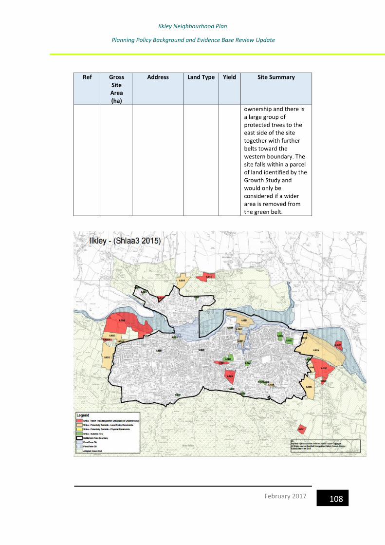
Ilkley Neighbourhood Plan
Planning Policy Background and Evidence Base Review Update
108 February 2017
Ref Gross Site Area (ha)
Address Land Type Yield Site Summary
ownership and there is a large group of protected trees to the east side of the site together with further belts toward the western boundary. The site falls within a parcel of land identified by the Growth Study and would only be considered if a wider area is removed from the green belt.

Ilkley Neighbourhood Plan
Planning Policy Background and Evidence Base Review Update
109 February 2017
Bradford District Settlement Study Update, 201115
The purpose of this study was to identify of the roles of individual settlements and the suitability of the settlements to accommodate the protected growth of the District. It contains the following assessment of Ilkley:
Location The town of Ilkley is located to the north of the Bradford District and which includes the adjacent settlements of Ben Rhydding to the east and Middleton to the north of the River Wharfe. The town is situated approximately 12 miles north of Bradford and 16 miles North West of Leeds, and lies mainly on the south bank of the River Wharfe in Wharfedale.
Historical Development There is historic evidence which shows that Ilkley first formed as a Roman settlement named Olicana, however it was abandoned by the early 5th century. Within the 14th century it had developed as a medieval village centred on Church Street and Brook Street. By the 18th century agriculture, some textiles and quarrying works were the primary industries; however a new wave of growth occurred following the development of the spa industries with the most notable one being at White Wells. By the mid 19th century the introduction of the railway saw many people coming to the area for the spas and subsequently led to the further expansion of the town. The decline of previously lucrative spa industries some years later was offset by the growth of tourism which was aided by improved access from the railway. Today, Ilkley continues to grow slowly and is now a popular dormitory town for people working nearby in Leeds and Bradford. Role of the Settlement Ilkley is the largest town in Wharfedale which has developed from a spa town to now fulfil a significant role as a self sustainable service, employment and transport hub for the surrounding area. It functions as a commuter settlement for Bradford and Leeds, yet is also a popular tourist centre for a range of outdoor activities.
15
https://www.bradford.gov.uk/Documents/EvidenceBase/Settlement%20Study//Settlement%
20Study%20Update%20(2011)%20Part%202.pdf

Ilkley Neighbourhood Plan
Planning Policy Background and Evidence Base Review Update
110 February 2017
Population and Social Structure The Ilkley Ward had a population of 13,828 at the time of the 2001 Census with over 25% of people aged over 65, nearly double the District’s average. This higher than average figure is due to the fact that Ilkley is a highly desirable place to live, particularly for the retired and elderly population as the settlement has a close proximity of local facilities and is set within a stunning setting with the opportunity for walking activities. In addition, there is a very limited BME population with 98% of the population being of white origin with less than 100 people of each minority ethnic groups. In terms of levels of deprivation, the Ilkley area is ranked as one of the least deprived areas both locally and nationally with Ben Rhydding being the least deprived area of the district. Housing There are 5,868 households within Ilkley, of which 82.6% of these are owner occupied; 10.5 % private and other are renting; leaving only 6.9% of households being rented from the Council or a housing association. The Strategic Housing Market Assessment (2009) identified tenure as an issue within Wharfedale suggesting that there needs to be more tenure diversity within the settlement. Ilkley contains an even proportion of housing types, unlike the District averages, which presents a range of opportunities for people living in this settlement. The housing types available consist of detached (28.6%) which is over two times the District average; semi-detached (23.7%); terraced (24.7%); and flats, conversations and shared dwellings (23.2%). The SHMA also highlights that properties within this area have a high market value, thus having an impact upon the affordability of properties for young first time buyers. Employment Ilkley is considered to fulfil a significant role as a service, employment and transport hub for the surrounding area. However, despite having an attractive setting and a significant rural centre, Ilkley has a shortfall of accommodation for businesses, especially those requiring large floorspaces. The majority of business accommodation is located within converted terraced properties or at first floor level above retail units, and much of this accommodation is deemed to be of poor in quality and unattractive to the wider market which seeks modern spacious premises.

Ilkley Neighbourhood Plan
Planning Policy Background and Evidence Base Review Update
111 February 2017
Retail Ilkley Town Centre occupies a position as a provider of convenience and comparison goods to its catchments population. The town is also a popular tourist destination with a good range of associated retail and leisure services. Community Facilities Ilkley has a local civic role which provides a range of services and facilities for its population; these include a health centre on Alexandra Road, a library and a town hall and an outdoor swimming pool (Lido). Further community facilities include: Education Ilkley has 4 primary schools and 1 secondary school which serve the local catchment area including the surrounding towns and villages. These are All Saints CE Primary, Ashlands Primary, Ben Rhydding Primary, the Sacred Heart Catholic Primary and Ilkley Grammar School Health Care Ilkley has a number of healthcare facilities within the town. These include Coronation Hospital, a doctor’s surgery, a number of dental surgeries and opticians and two pharmacies. Other Community Facilities Community Post Offices, libraries, halls and centres and other facilities are often vital services that serve a local population and enhance people’s lives. Ilkley has a post office, library and community halls. Open Space A wide range of open spaces and recreational facilities, which a number of outdoor facilities and recreational open spaces for the local community in Ilkley. The Open Space and Recreation Assessment (2007) identifies the following within this area:
Facilities Provision
Parks and Gardens • Riverside Gardens Park and West View Park (Darwin Gardens) are the local parks within Ilkley, • A gap in provision has been identified to the east of Ilkley.
Amenity Green Space • Figures for the Keighley constituency indicated that there are 69 sites, totally

Ilkley Neighbourhood Plan
Planning Policy Background and Evidence Base Review Update
112 February 2017
Facilities Provision
over 39ha, along with a further 22 green corridor sites. • There is a gap in provision within Ilkley.
Play Areas • Within the Keighley constituency area there are 54 play areas, 8 of which were of high quality and 6 were deemed to be below average. • Ilkley is identified as having gaps in the provision of play areas.
Allotments • There are 27 allotment spaces within the Keighley constituency. • There are minor gaps in provision to the western side of Ilkley.
Civic Spaces There are no civic spaces (hard surfaced areas designed for pedestrians) within the Keighley constituency
Playing Pitches • The study identifies minor shortfalls across the district for football, cricket, rugby league and union pitches.
Cemeteries • Ilkley cemetery serves this area; • No gaps have been identified.
There are a range of further leisure and recreational activities on offer in and around Ilkley, including Ilkley Golf Club, Ilkley Lawn Tennis and Squash Club along athletics, badminton, and walking clubs. More notably is the hugely popular Ilkley Lido which is open during the summer months for outdoor swimming; the facility attracts many visitors each year and is considered to be an important tourist magnet. The following emergency services are located in this area: • Ilkley Police Station is located on Riddings Road. • A fire station is located on Little Lane within Ilkley. • The nearest hospitals are Airedale in Steeton or Otley within the Leeds District Authority; both of these provide emergency and non-emergency care. Transport Ilkley is situated in the A65 Leeds Road which is the main road through the centre of Ilkley which provides links to Addingham, Otley in Leeds and Burley in Wharfedale and northern parts of the Bradford District. Ilkley benefits from having two railway stations, Ilkley and Ben Rhydding, both on the Wharfedale railway line with services to Leeds, Bradford Forster Square and Shipley. There is also a bus station within the town centre, from which a range of operators run, however there are no high frequency bus services

Ilkley Neighbourhood Plan
Planning Policy Background and Evidence Base Review Update
113 February 2017
(every 10 minutes) within Ilkley. Over 57% of the population travel over 5km to work. Natural Environment Ilkley is set within a stunning natural landscape with Ilkley Moor forming the town’s backdrop to the south. The unique rock formation, known as the Cow and Calf Rocks, is part of a gritstone band which runs along the Rombalds Moor and has formed distinctive cliffs or escarpment ridges such as this one which sits to the south of Ilkley overlooking the town. The rocks are a popular tourist spot. To the south of Ilkley is Ilkley Moor which falls within the Rombalds Ridge Landscape Character Area. The landscape is classified as gritstone moorland and its strength in character lies in its accessibility yet retaining an open moorland landscape on top of a plateau. The area of Ilkley Moor to Bingley Moor is identified as an area of high sensitivity due to its distinctive character which would be very susceptible to any change . The natural landscape also offers a number of outdoor activities, including rock climbing, walking, orienteering, bird watching, kite flying, mountain biking, fell running, horse riding, astronomy and archaeological pursuits. It is also in demand as a film location. Nature Conservation The area of land to the south of Ilkley forms part of the South Pennine Moor Special Protection Area (SPA). The area was designated by the Government under the EU Directive for Wild Birds (known as the Wild Birds Directive) 79/409. It is an area of international importance for the assemblage of a variety of rare and declining breeding bird populations. There are several designated Sites of Ecological and/or Geological Importance (SEGIs) within Ilkley, these consist of the land surrounding the River Wharfe, Middleton Woods, and the Cow and Calf Rocks on Ilkley Moor. Land Conditions Large areas of land to the north of Ilkley and to the south of Middleton around the River Wharfe fall within a flood risk zone. This land condition will be a constraint for any future development here.

Ilkley Neighbourhood Plan
Planning Policy Background and Evidence Base Review Update
114 February 2017
Local Heritage There are three Conservation Areas within the Ilkley area, these consist of: • Ilkley – covering a large proportion of the town including the roman core; central shopping area; railway town; Victorian and Edwardian suburbs and the residential expansion. • Middleton – covers a large proportion of the residential area to the north of the River Aire; and • Ben Rhydding – covering the historic core of this settlement. The private garden of ‘Heathcote’, a lavish former manor house in Ilkley, is considered to be a nationally important site which has been included in the Register of Parks and Gardens of Special Historic Interest in England. In addition, the private gardens of ‘Heber’s Ghyll’ are considered by the Council to be of local historic value. Key planning issues within Ilkley The following key issues have been identified for Ilkley:
• Providing for an older and aging population to ensure appropriate facilities and adequate housing provision is available for the growing elderly population.
• Lack of affordable homes for first time buyers and families within the area;
• This impact of the economic downturn on specialist retailers may result in the closure of many of these businesses, thus having a negative impact on Ilkley’s unique retail offer.
• Businesses may suffer from increased competition from local supermarkets such as Tesco’s and Booths. Smaller retail outlets selling convenience goods may not be able to compete at the same levels, therefore this would have a negative impact on their businesses and the wider town.
• Ilkley Grammar School is reportedly at or nearing its capacity. The Council will need to assess educational infrastructure in this area.
• The public have raised concerns regarding the capacity of the on the Wharfedale line. Mitigation measures will need to be sought to accommodate housing growth in this area.
Key planning opportunities within Ilkley Despite a number of town centre based issues, there are also a number of opportunities within the area which could be capitalised upon in the future. These include:

Ilkley Neighbourhood Plan
Planning Policy Background and Evidence Base Review Update
115 February 2017
• The growth of independent and specialist retail businesses will strengthen and underpin the towns’ unique retail offer, thus attracting more shoppers into the area.
• The refurbishment and/or upgrade of the existing premises stock in Ilkley would improve the attractiveness of the town for new businesses wishing to set up in the area.
• At present, Ilkley is a hotspot for a range of tourism activities and if this were to be managed in a sensitive but proactive manner then there may be opportunities for further growth in this sector. This anticipated growth may be particularly notable in the leisure and (outdoor) recreation field.
• Introduction of an Article 4 (2) Direction to provide addition protection to the historic fabric both the Ilkley and Ben Rhydding Conservation Areas.
4.2 Employment
Employment Land Review Update, 201116
The purpose of the Employment Land Review (ELR) is to provide evidence to support the development of the Bradford Local Plan. It provides an overview of Bradford economy, employment land situation, the wider functional economic area and an assessment as to whether the Borough’s current employment land stock is suitable for modern employment use. In terms of those aspects relevant to Ilkley, it notes that Ilkley has seen little
development of modern office accommodation, but there is a requirement
for an increase in the supply of office accommodation in the town centre.
The Tesco redevelopment will free up a town centre site which should be
used as an opportunity to deliver more modern developments to meet
latent demand from local companies.
Economic activity in the rural areas needs to be assessed and opportunities
to increase this activity capitalised on. The rural hinterland is home to small
scale smallholdings and farming operations – generally sheep farms with
some cattle, but this serves a local market as the farms are often too small
to provide adequate income for a profitable business to operate. Agriculture
16 http://www.bradford.gov.uk/NR/rdonlyres/28B7F26C-F672-4804-BFAA-
948317D05D30/0/EmploymentLandReviewUpdate2011.pdf

Ilkley Neighbourhood Plan
Planning Policy Background and Evidence Base Review Update
116 February 2017
is often supplemented by alternative sources of income and farmers should
be encouraged to diversify. Diversification activates may be farming related
such as food production and processing or farm shops, through to small scale
production of other products. Consideration should also be given to the
potential of the leisure market. UK holidays are still popular and
holidaymakers need accommodation. This ranges from B&B and guest house
operations through to self catering cottages in converted farm outbuildings.
Caravan and camping holidays have seen year on year growth for the last 5
years and this shows no sign of subsiding, particularly in tough economic
times. With minimal investment rural land owners can become operators of
caravan and camping sites which increase the level of sustainable rural
employment. Outdoor activity centres, horse riding facilities, livery stables
and the like should all be considered as suitable employment uses in the
rural areas and promoted, with applications for such uses treated
favourably. These uses should also be considered where protection of
employment sites is preferred.
In order for these changes in rural employment to be encouraged a supply
of employment land in rural areas should be maintained, but concentrated
on settlements with larger populations and better access to neighbouring
towns and cities. In the smaller settlements allocations should be removed
to leave unallocated sites with each application being dealt with on its
merits.
It concludes that Wharfedale consists largely of commuter settlements but
does contain a number of successful entrepreneurs. The focus should be on
the delivery of small to medium sized space, possibly using mixed use
4.3 Natural and Built Environment
Landscape
Natural England National Character Areas17
Natural England has produced profiles for England’s 159 National Character Areas (NCAs). These are areas that share similar landscape characteristics, and which follow natural lines in the landscape rather than administrative
17
http://publications.naturalengland.org.uk/publication/5459581769613312?category=587130

Ilkley Neighbourhood Plan
Planning Policy Background and Evidence Base Review Update
117 February 2017
boundaries, making them a good decision-making framework for the natural environment. Ilkley lies within NCA 36: Southern Pennines.
The Southern Pennines are described as part of the Pennine ridge of hills, lying between the Peak District National Park and the Yorkshire Dales National Park. This is a landscape of large-scale sweeping moorlands, pastures enclosed by drystone walls, and gritstone settlements contained within narrow valleys. The area contains internationally important mosaics of moorland habitats that support rare birds such as merlin, short-eared owl and twite. The peat soils, including blanket bog, store significant volumes of carbon. With its high rainfall and impervious rocks it is an important area for water supply, with many reservoirs supplying water to nearby conurbations. The Southern Pennines are also important for recreation due to the extensive open access areas and footpaths, and the
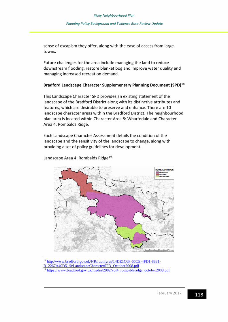
Ilkley Neighbourhood Plan
Planning Policy Background and Evidence Base Review Update
118 February 2017
sense of escapism they offer, along with the ease of access from large towns. Future challenges for the area include managing the land to reduce downstream flooding, restore blanket bog and improve water quality and managing increased recreation demand. Bradford Landscape Character Supplementary Planning Document (SPD)18 This Landscape Character SPD provides an existing statement of the landscape of the Bradford District along with its distinctive attributes and features, which are desirable to preserve and enhance. There are 10 landscape character areas within the Bradford District. The neighbourhood plan area is located within Character Area 8: Wharfedale and Character Area 4: Rombalds Ridge. Each Landscape Character Assessment details the condition of the landscape and the sensitivity of the landscape to change, along with providing a set of policy guidelines for development. Landscape Area 4: Rombalds Ridge19
18 http://www.bradford.gov.uk/NR/rdonlyres/14DE1C6F-66CE-4FD1-8831-
B12267A40D51/0/LandscapeCharacterSPD_October2008.pdf 19 https://www.bradford.gov.uk/media/2982/vol4_rombaldsridge_october2008.pdf

Ilkley Neighbourhood Plan
Planning Policy Background and Evidence Base Review Update
119 February 2017
The Rombalds Ridge character area is a primarily high level plateau with an upland character dominated by moorland. Strong cultural association, archaeological interest, ecological importance and recreation value add depth and meaning to this Character Area. The Rombalds Ridge separates the Aire and Wharfe Valleys, which run parallel in a northwest – southeast direction. The northern boundary is a distinctive moorland edge looking over Wharfedale adjoining the enclosed pastures and the town of Ilkley. A slightly less distinctive moorland edge bounds much of the southern boundary adjacent to the upland pastures. The southern eastern boundary with Airedale incorporates within the Character Area a perched plateau of mixed upland pastures and Baildon Moor before bounding the settlement of Baildon. To summarise the Character Area boundaries we have Wharfedale to the north, Airedale to the south, Esholt to the east and the District boundary with Craven to the west. The main landscape type in Rombalds is moorland covering approximately 60% of the area, with upland pastures, mixed upland pastures and small wooded valleys making up the remainder. Key Landscape Elements • Wild open exposed moorland • Fields enclosed by stone walls • Plantation woodland • Rock outcrops • Simple structure with few landscape elements. Landform The landform of the Character Area is dominated by Rombalds Moor, which forms an upland watershed between Wharfedale to the north and Airedale to the south, rising to a height of 402m. The landform comprises a number of distinct terraces or plateaux with a north facing scarp face incised by ghylls or small valleys forms by the streams running off the moor. Geology Rombalds Moor and Addingham Middle Moor consist of millstone grit bands of Namurian age interbedded with softer shales. These gritstone
Ilkley Neighbourhood Plan
Planning Policy Background and Evidence Base Review Update
120 February 2017
bands run along Rombalds Moor and form distinctive cliffs or escarpment ridges such as Rocky Valley, Cow and Calf Rocks and Hangingstones Quarry. The gritstones consist mainly of Woodhouse Grit, Woodhouse Grit Flags and Guiseley Grit. Evidence of sandstone quarrying can be seen at a number locations most notable those on the northern Wharfe Valley side. Soils Thin, acidic deposits of glacial till with shallow deposits of peat cover most of the moorland area. Deeper deposits of moorland peat can be found at Crawshaw Moss and Green Gates at Rombalds Moor. Grassland areas such as the upland and mixed upland pastures consists of shallow acidic, poor quality soils. Biodiversity The main ecological interest of the Rombalds Ridge Character Area lies in the large mosaic of moorland habitats on Rombalds Moor, part of the South Pennine Moors SPA, designated under the European Union Wild Birds Directive. It is an internationally important site for large breeding number of Merlin (Flaco columbarius), golden plover (Pluvialis apricaria) and twite (Carduelis flavirostris). Other significant sites of ecological value are:- • Sconce Crag SEGI – wetland on Baildon Moor, important for
uncommon species sundown (Drosera rotundifolia) and bod asphodel (Narthecium ossifragum), and the only know site in West Yorkshire for lesser twayblad (Listera cordata).
• Brown Bank Marsh SEGI – marshy grassland to the north of Silsden, with a good range of wetland species including the largest population of the Bottle Sedge (Carex rostrata) in the county.
• Ilkley Moor Plantation and White Crag Plantations BWA's – although these are conifer dominated woodlands, their size and contiguity with the moorland make them significant for sheltering a range of bird species, including short-eared owl, as well as having a significant visual impact on the landscape.
Overall Conclusions Rombalds Ridge can be regarded as very sensitive to change due to its strong character, high historic continuity, displaying a safe feeling of remoteness.

Ilkley Neighbourhood Plan
Planning Policy Background and Evidence Base Review Update
121 February 2017
The overriding character area strategy for Rombalds is to conserve the landscape elements that contribute to its strength. The moorland and upland pastures in particular are both in good condition with a strong character. Despite the perceived naturalness their future retention depends upon the existing landscape management practices continuing. For example heather burning or cutting on the moorland and grazing of sheep and cattle on the upland pastures. The strategy for the mixed upland pasture is to conserve and enhance, the loss of field boundaries is of particular concern. There is also opportunity to increase the tree cover in this landscape type. Landscape Character Types In this Character Area, these is one landscape character type in Ilkley:
• Gritstone moorland to the south of the parish Gritstone Moorland Description There are two areas of moorland within the Character Area Rombalds Moor and Baildon Moor. Rombalds Moor is made up of Ilkley Moor, Burley Moor, Hawksworth Moor, Bingley Moor, Morton Moor and Addingham High Moor. • Area 1. Rombalds Moor, forms the ridge line separating Airedale
and Wharfedale. It is the central backbone of the Character Area. Rombalds Moor attracts many visitors notably for its association with Ilkley Moor and the Cow and Calf Rocks.
• Its strength of character lies in its accessibility yet retaining an open moorland landscape on the top of the plateau. • Although relatively small areas of the moor are wooded they are locally significant, two coniferous plantations at High Moor and White Cragg and a number of deeply incised wooded cloughs on the moorland slopes notable Hanging Stones Quarry and Rock Valley to the rear of White Wells.
• Other notable features of the moor include a well-maintained dry stonewall running east-west along the ridge, and the rock outcrops of the Cow and Calf, Thimble Stones and East Buck Stones.
Landscape Strategy Analysis Simple well defined structured with lack of urban influences.
Ilkley Neighbourhood Plan
Planning Policy Background and Evidence Base Review Update
122 February 2017
Footpaths and walls are generally in good condition with regular maintenance of eroded areas from recreational pressure. Ecologically, the moor is a complex mix of heather, moorland grasses, blanket bog, plantation woodland, bracken and small wooded cloughs. The general condition and balance of these elements is good, bracken encroachment and the retention of wetland areas are key management issues. Policy Guidelines • The management objective for the moorland is to conserve the various habitats in a way, which balances the often-conflicting interest of public access and nature conservation. • Ilkley Moor and Baildon Moor are classified as Urban Common, as such there are certain rights and restrictions notably the right to graze sheep, and public access on foot and horseback is unlimited. • Most of Rombalds Moor is designated as a Special Protection Area (SPA) which is an internationally important site for the habitats of upland breeding birds. • Detailed landscape management plans have been prepared for both Ilkley Moor and Baildon Moor covering the key habitat types. • Upland Heath • Upland Grassland • Wetlands and open water • Woodland • Bracken • The aim is to obtain the widest possible adoption of the detailed management objectives among the private owners on Rombalds Moor. • Protect the universal value of Saltaire World Heritage Site and minimise the negative impact of development within the Buffer Zone on the World Heritage Site. Potential for Development Policy Guidelines • With a strong character, high historic continuity, open character and a prominent position in the landscape, this landscape can be considered very sensitive to development. • Any form of development should be severely restricted; and vertical structures should be located where topography constrains views of the site, and should avoid the interruption of prominent ridge and summit skylines.

Ilkley Neighbourhood Plan
Planning Policy Background and Evidence Base Review Update
123 February 2017
• Conservation of the open character is the key factor to prevent deterioration of the quality of this area, and mass tree planting is not considered appropriate. • Settlement is not generally a feature of the Rombalds Ridge gritstone moorland and any extension to the existing few farmsteads on the moorland fringe should be minimal to strictly limit any negative impact on this landscape. • Quarrying and peat extraction will not be permitted within this area. Landscape Area 8: Wharfedale20
Wharfedale has a strong visual connection with the adjoining Yorkshire Dales National Park and Nidderdale Area of Outstanding Beauty. This is partly due to its physical separation from Airedale by Rombalds Moor, but also because Wharfedale has avoided the full impact of the Industrial Revolution, possibly due to the better quality of soils and gently sloping valley sides which has supported a stronger agricultural land use. The valley of Wharfedale, which still retains much of its rural and agricultural
20 https://www.bradford.gov.uk/media/2986/vol8_wharfedale_october2008.pdf

Ilkley Neighbourhood Plan
Planning Policy Background and Evidence Base Review Update
124 February 2017
character, generally has a well-kept, prosperous appearance which contrasts with the craggy Ilkley Moor to the south. The main settlements of Addingham, Ilkley, Burley in Wharfedale and Menston are sited on the valley floor and, although substantial residential expansion has consolidated their centres they still retain their traditional character. These settlements have strong edges and are distinctly separated from each other. The River Wharfe forms the northern boundary of the District for the most part, separating it from the Nidderdale Area of Outstanding Beauty. The Rombalds Ridge character area forms a distinctive boundary to the south, with the rugged moorland edge following Cow Pasture/Hangingstone Road. Craven District forms the western boundary and Leeds District for the eastern edge. There are three landscape types within Wharfedale, the largest of which is the enclosed pastures which separate the settlements. The floodplain pasture is restricted to a narrow area within the valley floor to the south of the river and the wooded incline lies to the north of the river adjacent to Ilkley. In addition there are four settlements within the character area. Key Landscape Elements • Meandering River Wharfe, tree lined banks. • Stone walls, network of hedgerows and fenced field boundaries. • Medium to large sized fields dominated by boundary trees. • Well spaced settlements along valley bottom. • Tree dominated landscape throughout the landscape types. Landform While the landform is characterised by contrasts, overall the Wharfe Valley consists of gentle northern slopes outside the district and the steep southern slopes and crags. The character area consists of the valley floor and steeply rising slopes to the moorland fringe. Geology The underlying bedrock of Wharfedale is millstone grit, this impervious rock gives rise to the steep sided valley forming the southern side of Wharfedale from the River Wharfe at 75m A.O.D, the land ultimately reaching 400m A.O.D on Rombalds Moor.

Ilkley Neighbourhood Plan
Planning Policy Background and Evidence Base Review Update
125 February 2017
The present day topography is largely however the result of glacial activity, resulting in several different types of glacial till being deposited on the valley floor averaging 10-20cm in depth. These deposits range from boulder clay to sands and gravels in varying thickness and locations. The River Wharfe has cut down through these forming three distinctive river terraces and exposing these deposits. Landslips on the valley side are a common feature of Wharfedale. Soils Land use strongly reflected in the quality of soils. The glacial deposits of the valley floor have formed high quality Grade 2 and 3a soils which produce better quality grazing pastures than further up the valley sides, where thinner more acidic soils are reflected in poorer quality, often marginal, pasture land. Biodiversity Although Wharfedale contains no sites of national or international importance in terms of nature conservation, it does benefit from the diversity of habitats linked with the River Wharfe, a fertile valley abundant in woodland, wetlands and grasslands and all their associated wildlife. The sites of ecological significance within Wharfedale are:- • Ben Rhydding Gravel Pits SEGI – former gravel pits which have developed considerable botanical diversity, with over 300 plant species, including several regionally rare species, and the notable occurrence of the maritime species, sea club-rush (Bulboschoenus maritimus) and one nationally rare species, sickle leaved hare’s ear (Bupleurum falcatum). • Middleton Woods SEGI – an ancient woodland with a well structured and diverse example of an upland oak/birch woodland which has one of the best developed fern communities in the county; many of the other woodlands in Wharfedale would possible have had a similar structure before being fragmented. • River Wharfe SEGI – the most natural and least polluted of the major rivers in West Yorkshire, containing a wide range of aquatic and emergent plant species including regionally and nationally rare species of pondweeds and water-crowfoot. Also supports regionally rare and nationally protected fauna. Overall Conclusions With a strong character, medium historic continuity, little sense of remoteness (settled), medium significance of new development and intermediate pressure on the integrity of the landscape unit, the Wharfedale character are has moderate sensitivity.

Ilkley Neighbourhood Plan
Planning Policy Background and Evidence Base Review Update
126 February 2017
Although the wooded incline landscape types have managed to absorb the impact of settlement, the character of the more open pasture fields have proved more vulnerable to development and change. The landscape strategy for the character area in general is a mixture of conservation, enhancement and restoration. The strongly wooded character of Wharfedale should be conserved and protected against further development which would fragment the woodland canopy within the wooded incline, in particular, but also throughout the character area. Opportunities should also be sought, where possible, to encourage regeneration and planting, in order to ensure the long term continuity of the wooded character. There are opportunities to enhance the field boundaries within the character area. These are an important landscape element, especially within the enclosed pasture landscape type and whether they are walls, hedges or fencing they should be conserved, strengthened and restored where necessary. Opportunities for new development in Wharfedale are limited by the need to preserve the sharp edges of the existing settlements. The retention of the separate identity of the existing towns and villages through physical separation should be a long term aim. Additional woodland planting around the settlements will help to contain new development. Any new proposals in Wharfedale should also be assessed for their impact on the busy road network along the valley and across the valley slopes towards Airedale, to avoid adversely affecting the attractive quality of life of both residents and visitors. Landscape Character Types There are 3 landscape character types in Ilkley:
• Floodplain pasture in the north-eastern and north-western parts of the parish
• Enclosed pasture in the west and east
• Wooded incline to the north Floodplain Pasture Description
Ilkley Neighbourhood Plan
Planning Policy Background and Evidence Base Review Update
127 February 2017
• Due to the steeply rising ground to the south of the River Wharfe the floodplain pastures in the district are restricted to a fairly narrow valley floor corridor below 100m A.O.D. • Following the River Wharfe the landscape type extends from Burley in Wharfedale in the east to just below Addingham. The settlements of Burley and Ilkley dissect the pasture along with the A65 trunk road following the flat land of the valley bottom. • Field sizes tend to be larger than the enclosed pastures of the valley incline, although they are not as extensive as the wide open flood plain pastures north of the river. • Field enclosure is almost exclusively hedgerow with occasional fencing. • A number of other elements occur on this limited area of flat land dissecting the pastoral nature of the floodplain. The sewage works at Addingham and Burley in Wharfedale take advantage of the low lying location below settlements and close proximity to the river. Recreational activity has also taken advantage of this flat land in the river bottom, including extensive sports pitches at Ben Rhydding and close to Ilkley town centre. These are a major landscape element which create and even greater open aspect to this landscape type. Landscape Strategy Analysis • The strong character formulated from the balance of mature pasture fields, hedgerows, tree belts and the river environment is fragmented by sewage treatment plants, electricity poles and recreational buildings. • Hedgerows are in places gapped up with post and wire fences. Mature field trees are showing signs of decay. Policy Guidelines • The retention of the washland capacity of the floodplain is an essential requirement of the Environment Agency. Retention and continued use of the pastures for sheep grazing should be encouraged. • Hedgerows should be gapped up with a range of native species and hedgerows trees replanted. • Woodland blocks have an even-age mature nature and re-planting/ underplanting to encourage a more diverse age structure should be carried out. • The river and bankside environments are increasingly important wildlife habitats, and sensitive management needs to be undertaken to encourage a number of protected species, presently returning to the area. Conserve and enhance wetland habitats, such as wet meadows and marshy

Ilkley Neighbourhood Plan
Planning Policy Background and Evidence Base Review Update
128 February 2017
grasslands. The planting of willow, along with a coppice regime could encourage the otter return to this stretch of the Wharfe. • Opportunities for tree planting to screen detracting elements notably sewage works and recreational buildings. • Resist schemes which involve engineering to the river bank or canalising the river. Potential for Development Policy Guidelines This landscape with moderate strength of character, medium historic continuity and visible open character is moderately sensitive. • Although landscape change has occurred, weakening the character of the landscape, it has been limited to uses requiring the flat open aspect and low lying position, i.e. playing fields and associated buildings and sewage works. • The floodplain pastures have by their very nature only limited ability to accommodate change. The designated washlands and associated sensitive ecology adjacent to the River Wharfe are strictly controlled by the Environment Agency. • Should any development be considered on the higher ground away from the immediate environs of the river it would need to be small scale and take account of the traditional built settlement pattern and the hedge and field tree enclosure. Wharfedale Enclosed Pasture Description The enclosed pastures of Wharfedale occur on the north facing slope of the valley side to the east and west of Ilkley and running the full length of the character area. • The boundary to the south is the Rombalds Ridge character area moorland edge and to the north a combination of the district boundary, the floodplain pastures and the settlements of Menston, Burley in Wharfedale and Addingham. • In most areas the slopes are relatively steep and gently undulating; they have a well wooded character, made up of small blocks of woodland, groups of trees around scattered farmsteads, boundary trees and occasional isolated trees within the pasture fields. • Many small streams and springs flow from the upland through the pastures into the valley floor.

Ilkley Neighbourhood Plan
Planning Policy Background and Evidence Base Review Update
129 February 2017
• There are no large woodlands within these areas with the tree cover mainly consisting of scattered trees and small copses. They contain relatively little settlement other than farmsteads and isolated residential properties. • The field boundaries consist of mainly of dry stone walls and, occasionally, hedges and fences. Field patterns are relatively large and irregular in shape grazed mainly by sheep and cattle. Landscape Strategy Analysis A simple well structured landscape comprising of a balance of pastures enclosed by drystone walls, hedges and mixed styles of fencing, woodlands and isolated settlements. • There is a contrast between the landscape condition from the eastern and western extremities of the valley. The eastern area between Ben Rhydding and Menston has seen a change in the traditional agricultural land uses. This has resulted in some of the pastures becoming marginal as grazing is reduced, most noticeable on the higher ground with poorer soils. This is typified by bracken and rush as it reverts to a moorland vegetation. Horse grazing is also tending to reduce the quality of pasture grasslands as ragwort and thistle becoming more prominent, and field boundaries change from dry stone walls to smaller post and wire enclosures. Policy Guidelines Encourage the retention of traditional pastoral land use for sheep and cattle limiting horse grazing. • Retain the integrity of field sizes; restore hedges and walls; and replace wire fencing with traditional boundary treatment. • Strengthen planting around dwellings to absorb the built structure. Ornamental style planting is more acceptable in this location, although leylandii style hedging should be avoided. • Maintain the well wooded, ‘parkland’ character to the pastures. Potential for Development Policy Guidelines • With a strong character, medium historic continuity and having a varied visible exposure these areas have a moderate sensitivity to development. • It is important to prevent the spread of development which would destroy the identity of the settlements of Menston, Burley in Wharfedale and Ilkley. Keep settlement edges neat and discreet and utilise a framework of tree planting.

Ilkley Neighbourhood Plan
Planning Policy Background and Evidence Base Review Update
130 February 2017
• The landscape has however the capacity to accommodate small pockets of residential development in a parkland setting. The visual impact of any proposal would need to be considered in detail and may involve additional on-site and off-site planting to absorb the development into the landscape. The associated infrastructure of access roads, lighting and signage, would also need to be carefully considered. Wooded Incline Description Located to the north of Ilkley and the River Wharfe, the wooded incline consists of gentle slopes in a small enclave of the district adjacent to the Nidderdale Area of Outstanding Beauty. The woodland consists mainly of broadleaved species with occasional coniferous trees. There are large areas of ancient woodlands notably Middleton Woods, and areas of mature but younger woodland which contain some exotic species. Land cover is predominately woodland with small areas of pasture and a mixed range of settlement in the form of detached residential properties and farmsteads. Landscape Strategy Analysis The woodland structure provides unity to the landscape as a balanced framework for settlement and pasture pockets. The condition of the wooded incline is generally good although some of the woodlands are mature and will need management to ensure their continuity. Policy Guidelines • Although the general condition of the landscape is good in order to
conserve this there will be a need to manage for the future. • Maintain the existing level of tree cover by a phased programme of
planting and management. This should conserve the ecological value of the SEGI designated woodlands for their wildlife and biodiversity value, through management and removal of exotic species. There is more scope for ornamental tree planting in close proximity to settlement, and individual dwellings.
• Woodland areas should be managed to encourage public access and incorporate environmental interpretation.

Ilkley Neighbourhood Plan
Planning Policy Background and Evidence Base Review Update
131 February 2017
Potential for Development Policy Guidelines • With strong character, medium historic continuity and prominent
and enclosed landscape, this area is sensitive to development. • However, there is continuing pressure for small scale residential
development of individual or small numbers of dwellings within these well-wooded areas, especially within the grounds of large houses on the wooded valley slopes. Although these can be sometimes be accommodated within the woodland canopy, there is a danger that the effect of these developments will substantially deplete the long term tree cover of this landscape type and should be resisted. Furthermore, in most instances, these developments would destroy ground flora of biodiversity value and the habitats of some wildlife species. This policy guideline could also be applied to the well-wooded areas of the settlement of Ilkley.
• The pastures immediately below the wooded incline could accommodate some small scale development, if this was framed by substantial tree planting to link the adjoining woodland.
The SPD also sets out detailed design guidance
Flood Risk
Strategic Flood Risk Assessment
Strategic Flood Risk Assessments are completed in two consecutive stages:
• Level 1 SFRA which is a strategic assessment of all forms of flood risk
in an area
• Level 2 SFRA which is a more detailed flood risk assessment of areas
which have been identified as potential development sites
Bradford Council commissioned consultants to undertake a Level 1 Strategic
Flood Risk Assessment (SFRA) February 2011 which was updated in February
2014.

Ilkley Neighbourhood Plan
Planning Policy Background and Evidence Base Review Update
132 February 2017
Bradford Strategic Flood Risk Assessment, Level 1- JBA Consulting,
February 2011 (Amended February 2014)21
This Level 1 SFRA provides some useful information about flood risk in
Bradford District and explains current National, Regional and local land use
planning and flood risk management policy drivers in respect of potential
flooding from all sources. It provides information on key rivers and
watercourses and current Environment Agency flood risk management
plans, strategies and schemes. The Sequential and Exception Tests are
essential requirements and the SFRA explains the Risk Based Sequential
Approach in which these tests are carried out for proposed development
allocations; and recommends the use of flood risk indicators and a flood risk
balance sheet to assist planners in their strategic land use considerations.
It highlights the fact that flood risk is an important consideration in land use planning and can greatly impact on the sustainability of various land uses in all locations. Once the Sequential Test and Exception Test (where necessary) have been applied, the assessment of associated flood risk information will then influence the land use planning decision at whatever level it is being considered. Land use policies and wider strategic decisions involving social and economic development in development plan documents will be influenced and shaped by the sequential approach informed by this SFRA. It emphasises the importance of Green Infrastructure in managing flood risk. Green Infrastructure (GI) is a planned and managed network of natural environmental components and green spaces that intersperse and connect the urban centres, suburbs and rural fringe consisting of: • Open Spaces – parks, woodlands, nature reserves, lakes • Linkages – River corridors and canals, pathways and cycle routes and greenways • Networks of “urban green” – private gardens, street trees, verges and green roofs. Green spaces can be used to manage flood risk including storm flows. It may also free up water storage capacity in existing infrastructure to reduce risk of damage to urban property, particularly in city centres and vulnerable urban regeneration areas.
21 http://www.bradford.gov.uk/NR/rdonlyres/44E7F4AD-AD3E-439A-B977-
2928FF22A1C1/0/2008s3607Level1reportDRAFTFINAL_Feb2014_.pdf

Ilkley Neighbourhood Plan
Planning Policy Background and Evidence Base Review Update
133 February 2017
GI can also improve accessibility to waterways and improve water quality, supporting regeneration and improving opportunity for leisure, economic activity and biodiversity. It can also reduce the urban heat island effect, reduce erosion and improve water quality. GI should be incorporated into master planning and individual sites, directed by the need to retain exceedance flood paths and natural attenuation of flood flows. River corridors identified as functional floodplain are an excellent linkage of GI and can provide storage during a flood event. Areas identified within the urban environment or upstream of a critical surface water flood areas should be incorporated into council GI strategies. Opening up land to create flow paths or flood storage areas can help protect current and future developments.
Environment Agency Flood Map for Planning (Rivers and Sea)22
22 http://maps.environment-
agency.gov.uk/wiyby/wiybyController?x=411500.0&y=447500.0&topic=floodmap&ep=m
ap&scale=9&location=Ilkley,%20Bradford&lang=_e&layerGroups=default&distance=&te
xtonly=off#x=411500&y=447500&lg=1,2,10,&scale=8

Ilkley Neighbourhood Plan
Planning Policy Background and Evidence Base Review Update
134 February 2017
Biodiversity South Pennine Moors Special Area of Conservation (SAC)/South Pennine Moors Phase 2 Special Protection Area (SPA)23 These two European sites have been designated to conserve similar groups of upland habitats, wading birds and raptors. The South Pennine Moors were designated as SPA in two phases in 1996 and 1997 and were further extended in 2000. The SPA is of European importance for several upland breeding bird species, including birds of prey and waders. Both merlin and golden plover feed upon farmland or in-bye land on the edge of the moors that is outside of the SPA boundary. This is considered important to the long term conservation of the SPA population of these birds.
The site also qualifies for designation under the Birds Directive by supporting internationally important breeding populations of the following regularly occurring migratory species: common sandpiper, short-eared owl, dunlin, twite, common snipe, curlew, wheatear, golden plover, whinchat, redshank, ring ouzel and lapwing.
23 http://publications.naturalengland.org.uk/publication/4885083764817920
Ilkley Neighbourhood Plan
Planning Policy Background and Evidence Base Review Update
135 February 2017
The overriding objective for the SPA is to ensure that the integrity of the site is maintained or restored as appropriate, and ensure that the site contributes to achieving the aims of the Wild Birds Directive. The South Pennine Moors SAC was selected for its representation of three Annex 1 habitat types (European dry heaths, Blanket bogs, and Old sessile oak woodlands) while a further two were subsequently identified as being present as qualifying features within the SAC (Northern Atlantic wet heaths, and Transition mires and quaking bogs). In terms of the SAC, the overriding conservation objective is to ensure that the integrity of the site is maintained or restored as appropriate, and ensure that the site contributes to achieving the Favourable Conservation Status of its Qualifying Features Built Heritage Conservation Areas There are three Conservation Areas in Ilkley:
• Ben Rhydding
• Ilkley
• Middleton Ben Rhydding Conservation Area Appraisal, July 200624 This Conservation Area Appraisal describes the character of a conservation area. It also describes the changes that have been happening to the conservation area and finishes with management proposals which will help to conserve and enhance the area’s special character and improve decision making.
24 https://www.bradford.gov.uk/media/2334/benrhyddingappraisal.pdf
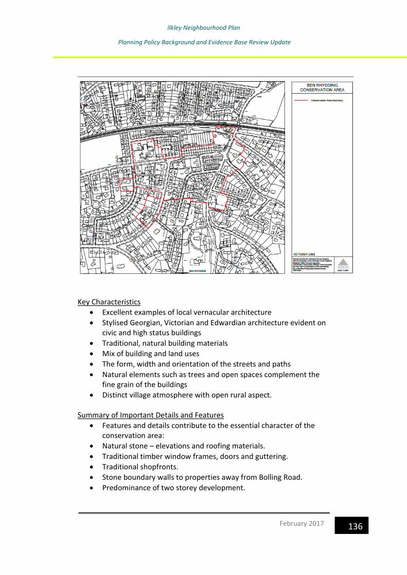
Ilkley Neighbourhood Plan
Planning Policy Background and Evidence Base Review Update
136 February 2017
Key Characteristics
• Excellent examples of local vernacular architecture
• Stylised Georgian, Victorian and Edwardian architecture evident on civic and high status buildings
• Traditional, natural building materials
• Mix of building and land uses
• The form, width and orientation of the streets and paths
• Natural elements such as trees and open spaces complement the fine grain of the buildings
• Distinct village atmosphere with open rural aspect. Summary of Important Details and Features
• Features and details contribute to the essential character of the conservation area:
• Natural stone – elevations and roofing materials.
• Traditional timber window frames, doors and guttering.
• Traditional shopfronts.
• Stone boundary walls to properties away from Bolling Road.
• Predominance of two storey development.

Ilkley Neighbourhood Plan
Planning Policy Background and Evidence Base Review Update
137 February 2017
• Mixture of building types and architectural styles.
• Snickets and historic street pattern, particularly the width and orientation of Bolling Road
Strengths
• A high quality built environment.
• The authenticity score of 93% for the conservation area as a whole is higher than all other conservation areas surveyed in the district so far.
• The majority of buildings retain most features and details.
• The area retains a distinct village character through a mixture of buildings and land uses; a busy core and quieter outer areas.
• Buildings on the important thoroughfares of Bolling Road retain a great deal of traditional character.
• The majority of shop fronts retain high levels of traditional features and details.
• The majority of Listed Buildings retain high levels of features and details.
• Street pattern has changed very little.
• Lack of modern engineering to some streets. Weaknesses
• Small minority of vacant or under used buildings and sites.
• High proportion of modern engineering to main throughfares and streets.
Objectives
• Improve the quality and amenity value of the public realm, open spaces and highway materials in Ben Rhydding
• Retain the traditional scale, proportion and character of the shopping /business areas in Ben Rhydding
• Preserve and enhance features and details that contribute to the character of Ben Rhydding
• Promote good quality new development
• Retain the commercial activity in Ben Rhydding and ensure all investment is contributing to the character of the conservation area and its activities.
• Retain important trees

Ilkley Neighbourhood Plan
Planning Policy Background and Evidence Base Review Update
138 February 2017
Ilkley Conservation Area Appraisal, November 200625 Ilkley conservation area covers the historic core of the settlement which retains elements from various stages in its history and development
Key Characteristics
• Excellent examples of a variety of architectural styles and designs, including Gothic, Italianate and Classical; Edwardian styles including Arts and Crafts and Victorian terraces.
• Six unique and distinct character zones (Roman Core, Shopping Core, Spa Town, Railway Town, Victorian Suburbs and the Residential Expansion).
• Traditional, natural building materials.
• The form, width and orientation of the streets and paths.
• Natural elements such as trees and open spaces complement the fine grain of the buildings.
• The topography and spectacular rural setting beneath Ilkley Moor.
25 https://www.bradford.gov.uk/media/2414/ilkleyappraisal.pdf
Ilkley Neighbourhood Plan
Planning Policy Background and Evidence Base Review Update
139 February 2017
Character Zones
Within Ilkley conservation Area, 6 character zones have been identified
which exude their own unique character and architectural styles.
1. Roman Core
Centring on The Manor House and the Parish Church on Church Street, this
area contains some of the oldest buildings in Ilkley which date as far back
as the 13th century. The large areas of open space to the north (Riverside
Gardens) provide splendid views across the river and are important to the
setting of these key listed buildings.
2. Shopping Core
Focused on Brook Street and The Grove, this area forms the busy
commercial centre of the town which is the product of a significant
rebuilding and expansion of the old village in the second half of the
nineteenth century. The contribution of well detailed traditional shopfronts
and tree lined streets are imperative for the retention of this area's
character.
3. Railway Town
Since the arrival of the railway in 1865, the station has formed the centre
piece of this sector which also consists of areas of terraced working class
houses between Railway Road and Leeds Road.
4. Spa Town
The fashion amongst the upper class society for spa water treatments from
the start of the 18th century began a period of expansion to the south and
south east of the town and the building Summary of the Character Zones of
a number of institutions devoted to hydrotherapy. Focused around Wells
Road, Crossbeck Road and onto the Moors, there are a number of buildings
which still exude the grandeur of this former lucrative industry, namely
White Wells (1844), Troutbeck (1863) and Rockwood (1871).
5. Victorian and Edwardian Suburbs
The expansion of Ilkley during 1865-1901 saw the building of a large
number and wide variety of dwellings, representing a range of Victorian
and Edwardian architecture. These dwellings provide a visual quality and
are harmonious in terms of design, scale and materials, thus contributing
Ilkley Neighbourhood Plan
Planning Policy Background and Evidence Base Review Update
140 February 2017
to a high quality environment. This character zone includes properties on
Albany Walk, Parish Ghyll Road and to the north on Bolton Bridge Road.
6. Residential Expansion
To the west of the conservation area, around Queens Road, Queens Drive,
Hebers Ghyll Drive and Panorama Drive, the suburban growth of the late
nineteenth century created a somewhat different character which
consisted of larger family sized housing with elements of new and old
architectural styles
Features and Details
• Unique mix of building types and architectural styles throughout the Conservation Area;
• A variety of massing, height and scales of development;
• Natural course gritstone - elevations;
• A variety of roof materials - stone slates (on earlier properties around the central areas); Welsh/blue slate or red terracotta tiles (on later properties);
• Traditional timber window frames (either sash or side hung casements), painted timber four panelled doors and guttering;
• Corniced chimney stacks;
• Unpainted stonework;
• Traditional timber shop fronts with stone carved details and recessed doorways;
• Stone boundary walls on residential properties.
Strengths
• A high quality built environment.
• The authenticity score of 83% for the conservation area as a whole. This is higher than most other conservation areas surveyed in the district so far.
• A large majority of pattern or qualities have survived in their original form.
• The character of the town is still clear and well preserved through a mixture of buildings and land uses, busy cores and quiet outer areas.
• Buildings on the important thoroughfares of Church Street, Brook Street and The Grove retain a great deal of traditional character.

Ilkley Neighbourhood Plan
Planning Policy Background and Evidence Base Review Update
141 February 2017
• The survival of good timber shop fronts provide a pattern for replacements on other buildings.
• The majority of Listed Buildings retain high levels of features and details.
• Street pattern has changed very little.
• Lack of modern engineering to some streets.
• The setting of the conservation area is well retained.
Weaknesses
• On average, the Railway Town character zone scored marginally worse that the other areas within the conservation area in terms of authenticity.
• A large amount of traditional windows and doors have been removed throughout the conservation area.
• Modern and inappropriately altered traditional shopfronts are fairly common within the Shopping Core character zone and are detracting from the street scene;
• The designs of some new developments are considered to be poor and weak, thus failing to uphold the prevailing character of the area.
• On average, the listed buildings in the conservation area scored only marginally worse than the unlisted buildings in terms of authenticity.
Objectives
• Improve the quality and amenity value of the public realm, open spaces and highway materials in Ilkley
• Retain the traditional scale, proportion and character of the shopping /business areas in Ilkley
• Preserve and enhance features and details that contribute to the character of Ilkley
• Promote good quality new development
• Retain important trees

Ilkley Neighbourhood Plan
Planning Policy Background and Evidence Base Review Update
142 February 2017
Middleton Conservation Area Appraisal, February 200926
Key Characteristics
• Large houses, wide roads, generous landscaped gardens and mature trees and hedgerows that create a spacious, leafy and salubrious sub-urban character.
• A range of building styles and ages, including the 17th century manor house Low Hall, early 20th century Arts and Crafts and Vernacular Revival houses, limited but good examples of 1930s modernist architecture, and more recent dwellings of varying quality built between the 1960s and the present day.
• A mixture of natural and man made building materials which reflect the age and architectural styles of different buildings within the conservation area. The following summarises the key elements of the character of the Middleton conservation area:
• Predominantly residential but with large areas of open space and sports and recreational facilities along the banks of the Wharfe.
26 https://www.bradford.gov.uk/media/2482/middletonappraisal.pdf

Ilkley Neighbourhood Plan
Planning Policy Background and Evidence Base Review Update
143 February 2017
• Middleton Woods to the north and the river to the south, provide a high quality setting.
Important Features and Details
• An abundance of hedgerows and mature trees throughout the area with denser woodland to the north of Curly Hill.
• Despite the considerable size of many houses, due to the low building to plot ratio, many houses appear subservient within their landscaped gardens.
• Vernacular Revival houses built with Ilkley Gritstone walls and slate roofs.
• Arts and Crafts houses built with a mixture of render and Ilkley Gritstone walls with red clay tile roofs.
• Traditional houses (built before 1956) retain many original features, including leaded and stained glass, timber or metal window frames, wooden doors, bay windows and chimneys with original pots.
• The 1930s Ilkley Lido and large areas of open space along the banks of the river.
• Footpaths provide alternative routes throughout the area and along the banks of the River Wharfe, with three historic bridges that provide links to Ilkley.
• Traditional street furniture/ facilities, including a listed post box, a traditional red telephone box and an old iron street lamp.
Strengths
• Many buildings retain almost all of their traditional features and details, including original walling and roofing materials.
• Buildings are generally well maintained and there are no vacant or seriously neglected buildings.
• An abundance of mature trees and hedgerows which contribute to the leafy sub-urban character of the area.
• The spaces about buildings, particularly gardens, are landscaped and well maintained.
• The street pattern has changed little since it was laid out by the Wharfedale Estate Company.
• The spectacular Grade II* listed Low Hall retains many of its original features and details and the ancillary buildings, which were once

Ilkley Neighbourhood Plan
Planning Policy Background and Evidence Base Review Update
144 February 2017
within the properties grounds, have been retained and sensitively converted.
• There are some good examples of new developments that uphold the character of the area.
• The high quality setting of the conservation area is well retained.
Weaknesses
• Many of the properties built post 1956 detract from the wider character of the area and disrupt the original street pattern.
• Some of buildings and structures associated with sporting and recreational facilities detract from the quality of the area.
• Some traditional buildings have been unsympathetically modernised, particularly notable is the use of modern concrete tile roofing materials and UPVC window frames.
Objectives
• Improve the quality and amenity value of the public realm
• Preserve and enhance features and details that contribute to the character of Middleton Conservation Area
• Maintenance of footpaths and boundary walls
• Promote good quality new development
• Preserve the spatial and landscape qualities within the Middleton Conservation Area
• Retain important trees
4.4 Retail
Bradford Retail and Leisure Study Update, May 201327
This study was undertaken to inform the Bradford Core Strategy. In terms of
Ilkley Town Centre, a site visit undertaken in March 2012 as part of the Study
identified that the 245 units within the town centre comprise a total
floorspace of 37,880 sq.m.
The Primary Shopping Area of Ilkley, as defined in the RUDP Proposals Map,
is concentrated along Brook Street, Grove Promenade and The Grove. The
27 http://www.bradford.gov.uk/NR/rdonlyres/366D9149-505E-4191-A01A-
5080A2EB76AC/0/BRLSUpdateAppendices.pdf

Ilkley Neighbourhood Plan
Planning Policy Background and Evidence Base Review Update
145 February 2017
RUDP also identifies a wider Central Shopping Area (CSA) which
encompasses some additional streets, notably: Leeds Road, Church Street
and Station Road. Whilst Brook Street accommodates the majority of
national operators in Ilkley, for example, Boots, Costa, the Co-op, Dorothy
Perkins and Thomas Cook, there is also a strong proportion of high quality
independent retailers in the centre, reflecting its role as a key tourist
destination.
There is a strong level of convenience, comparison, retail service and leisure
service operators in the town centre, with the Booths, Marks and Spencer
Simply Food, Boyes and Tesco stores acting as the key anchor foodstores.
The consented scheme for a new Tesco store on Railway Road will also
create an additional gross floorspace sales area of 2,484 sq.m, with the
opening of the new M-local format store in July 2011 also creating additional
convenience goods floorspace. Vacancy levels in the town centre are less
than half the respective national average rates, though there has been a
clear increase (8 units) in vacancies since the March 2007 survey.
The results of the in-street and business survey show that most (29%) people
choose to visit Ilkley due to the shopping environment, with the main reason
(35%) for respondents being in Ilkley on the day of the survey being to
browse. The majority of respondents to the survey consider that Ilkley town
centre performs better than other centres in relation to several factors,
including general environment (84%), cleanliness (80%), quality of shops
(79%) and independent shops (77%). The main area where respondents
considered Ilkley to perform worse than other centres was car parking
provision (39%) and car parking prices (28%). However, this contradicts an
earlier question to which the majority of those travelling to Ilkley by car
stated that they were satisfied with car parking costs and had no difficulty
parking. When asked how Ilkley town centre could be improved, 28%
suggested reducing traffic congestion and 20% suggested more parking.
Respondents to the business survey suggested a number of measures to
improve Ilkley; these included more independent traders, a better mix of
short/long stay parking and greater promotion of the centre. It is interesting
that the businesses suggest more independent shops would improve the
centre, given that the majority of respondents to the in-street survey
consider that Ilkley performs better than other centres in this regard.
However, it is likely to be the case that businesses in the centre want to

Ilkley Neighbourhood Plan
Planning Policy Background and Evidence Base Review Update
146 February 2017
maintain and enhance the number of independent shops. Respondents to
the business survey rated Ilkley’s public realm highly.
Since the BRLS (2008), there has been a decline in the number of
convenience and comparison units in the town centre, whilst there has been
an increase in the level of retail and leisure service operators. The health
check has identified that although Ilkley experienced a decline in its rankings
by 14 places between 2006 and 2011 (from 583 to 569), several other
indicators show that the town centre is performing well and continues to
provide an attractive shopping environment for local residents and visitors.
The Study concluded that, in terms of Ilkley, the proposed Tesco
replacement store will meet the town’s future requirements over the plan
period and there is no need to plan for any new provision
4.5 Infrastructure
Bradford District Wide Transport Strategy 201028
The purpose of this strategy was to establish the strategic impacts, in both absolute and relative terms, of the Core Strategy proposals on the highway
28 http://www.bradford.gov.uk/NR/rdonlyres/128F957F-317D-4BB3-B6CE-
588EFD745E8E/0/BradfordTransportStudy.pdf

Ilkley Neighbourhood Plan
Planning Policy Background and Evidence Base Review Update
147 February 2017
and public transport networks throughout the Bradford District, and on an intra-district level where relevant.
It also provides an assessment of specific measures needed to mitigate the key impacts of the Core Strategy proposals. This will identify the transport improvements, including measures to encourage modal shift away from the car, required to implement the Core Strategy without unacceptable impacts on the highway network and ensuring accessibility by public transport and other non-car modes. Consultation with neighbouring districts has also allowed the study to take account of wider transport issues such as cross-border travel patterns, public transport corridors and concerns over child safety.
In relation to the level of development in Wharfedale proposed in the Core Strategy, concentrated in Addingham, Ilkley, Burley and Menston, the Strategy concludes that additional demand will be highest between Burley and Shipley, with around 1000 – 1400 extra vehicles in both directions split between the A65/A6038 and parallel routes. There are currently no significant transport schemes currently planned for the A65/A6038 corridor, above those shared with the Airedale corridor (such as improved interchange at Shipley). The report considers options for potential transport improvements in the corridor, such as highways Improvements/re-configuration of junctions between A65 and A6038 in Menston and Guiseley, improvements to junctions of A6038/A657 and Otley Road/Baildon Road in Shipley. Cross-border working with Leeds will be necessary to mitigate traffic impacts on this corridor. It is recommended that there is a focus on making best use of the existing rail services on the Wharfedale line, and specifically, encouraging modal shift to rail from car by improving the provision of Park and Ride at all outlying rail stations.
Bradford Local Infrastructure Plan, October 201329
The Local Infrastructure Plan is part of the evidence base for the Bradford District Local Plan and will play a key role in delivering the vision set out in
29 http://www.bradford.gov.uk/NR/rdonlyres/55A7CC83-26E2-4754-85D6-
AC6F659B9286/0/LIPUpdate.pdf

Ilkley Neighbourhood Plan
Planning Policy Background and Evidence Base Review Update
148 February 2017
the District’s Sustainable Community Strategy and the Local Plan Core Strategy. The purpose of Local Infrastructure Plan is to provide an infrastructure capacity assessment for the District. This includes working in partnership with physical, social and green infrastructure providers to establish what infrastructure provision there is in the district, and identifying any gaps or capacity issues within the existing provision. The Local Infrastructure Plan also provides an initial assessment of what infrastructure will be required to support development within the District over the Local Plan period and how it could be implemented The report concludes that education Infrastructure could pose a significant
challenge to delivering growth. In terms of flood risk and transport, on-going
work is required to ensure that they do not pose significant challenge to
delivering growth.
Specifically, it identifies a shortfall of children play areas in Ilkley, Addingham
and Burley-in-Wharfedale. Upgrading of certain play areas as well as
installation of new equipped ones will be required to reduce the significant
catchment gap. Maintaining the overall quality and increasing the level of
accessibility to these existing green spaces within Wharfedale will be vital to
fulfilling the objectives for future development in the area.
Wharfedale also has the largest allotment waiting list in the District. There
are no plans to create any new allotments, but the Council are trying to
redevelop underused or vacant / overgrown plots to make them available to
people on the waiting list.
There is likely to be a requirement to deliver new open spaces in the future,
when the exact location of housing sites is confirmed.
4.6 Community Infrastructure Levy
The Community Infrastructure Levy (CIL) is a statutory way of collecting
developer contributions to help fund infrastructure projects such as
transport schemes and community facilities, to support new development
in the area. Under the CIL arrangements local authorities can charge a
locally set rate per square metre on many types of new development.
Bradford Council consulted on a Draft Charging Schedule (DCS) between 14 December 2015 and 8 February 2016. This was submitted for examination in May 2016 with the examination being held in October 2016.
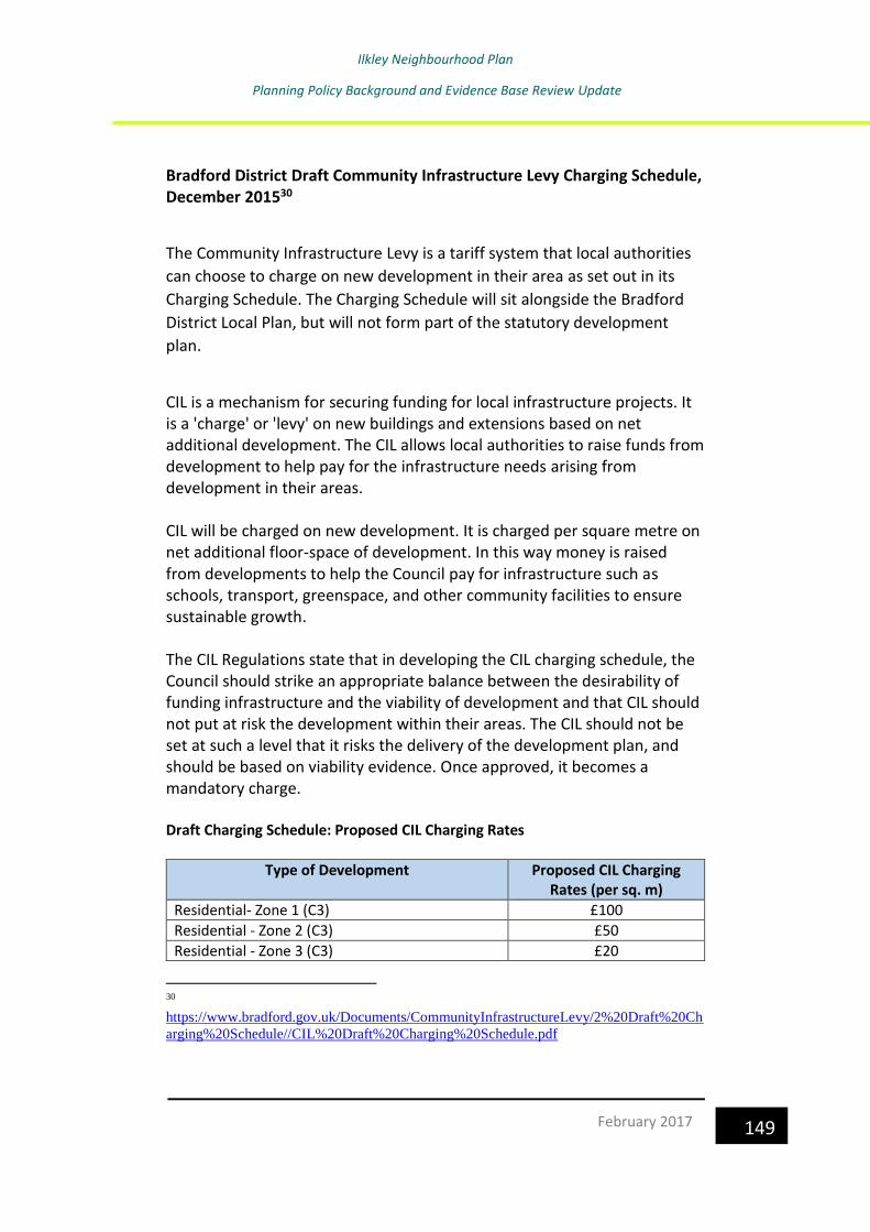
Ilkley Neighbourhood Plan
Planning Policy Background and Evidence Base Review Update
149 February 2017
Bradford District Draft Community Infrastructure Levy Charging Schedule, December 201530
The Community Infrastructure Levy is a tariff system that local authorities
can choose to charge on new development in their area as set out in its
Charging Schedule. The Charging Schedule will sit alongside the Bradford
District Local Plan, but will not form part of the statutory development
plan.
CIL is a mechanism for securing funding for local infrastructure projects. It is a 'charge' or 'levy' on new buildings and extensions based on net additional development. The CIL allows local authorities to raise funds from development to help pay for the infrastructure needs arising from development in their areas. CIL will be charged on new development. It is charged per square metre on net additional floor-space of development. In this way money is raised from developments to help the Council pay for infrastructure such as schools, transport, greenspace, and other community facilities to ensure sustainable growth. The CIL Regulations state that in developing the CIL charging schedule, the Council should strike an appropriate balance between the desirability of funding infrastructure and the viability of development and that CIL should not put at risk the development within their areas. The CIL should not be set at such a level that it risks the delivery of the development plan, and should be based on viability evidence. Once approved, it becomes a mandatory charge. Draft Charging Schedule: Proposed CIL Charging Rates
Type of Development Proposed CIL Charging Rates (per sq. m)
Residential- Zone 1 (C3) £100
Residential - Zone 2 (C3) £50
Residential - Zone 3 (C3) £20
30
https://www.bradford.gov.uk/Documents/CommunityInfrastructureLevy/2%20Draft%20Ch
arging%20Schedule//CIL%20Draft%20Charging%20Schedule.pdf

Ilkley Neighbourhood Plan
Planning Policy Background and Evidence Base Review Update
150 February 2017
Type of Development Proposed CIL Charging Rates (per sq. m)
Residential - Zone 4(C3) £5
Retail warehousing (Central Bradford) £85
Large Supermarket (>2000 sq m) £50
All other uses not cited above £0
Ilkley is in Residential Zone 1
Ilkley Neighbourhood Plan
Planning Policy Background and Evidence Base Review Update
151 February 2017
In her report (December 2016)31, the examiner concluded that the Draft Bradford District Community Infrastructure Levy Charging Schedule provides an appropriate basis for the collection of the levy in the area. The Council has sufficient evidence to support the schedule and can show that the levy is set at a level that will not put the overall development of the area at risk. However, two modifications are needed to meet the statutory requirements. These can be summarised as follows:
• That the CIL charge for ‘Residential- Zone 4 (C3)’ is reduced from £5 to £0 per square metre (psm).
• That the CIL charge for ‘Residential- Zones 1- 3 (C3)’ includes a footnote excluding specialist older persons’ housing.
The CIL Regulations 2010 (as amended) make provision for three classes of development that are exempt from any CIL liability. These are:
• Affordable housing;
• Charitable developments that are used wholly, or mainly for charitable purposes; and
• Self-build housing The Council may also consider introducing an Exceptions Policy enabling the two other areas of discretionary exemptions, as set out in the regulations, namely:
• Developments by charities which are held as an investment from which the profits are applied for charitable purposes; and
• Where a specific scheme cannot afford to pay the levy. Charging authorities will be required to pass a proportion of CIL receipts to town or parish councils. Town and parish councils will receive a 15% share of CIL revenue from development in their area, subject to a cap of £100 per household in the town or parish council area. Where a neighbourhood has drawn up a Neighbourhood Plan, this share would increase to an uncapped 25 per cent.
31 https://www.bradford.gov.uk/media/3557/bradfordcilfinalreport.pdf

Ilkley Neighbourhood Plan
Planning Policy Background and Evidence Base Review Update
152 February 2017
5.0 Supplementary Planning Documents
Supplementary Planning Documents (SPDs) are used to amplify
development plan polices on separate topics or on different spatial scales.
SPDs are not subject to independent inspection via an examination in
public, and are simpler to update and adopt on a regular basis by the local
council.
The Landscape Character SPD has already been considered under section
4.3. The following Supplementary Planning Document was adopted by
Bradford Council in February 2008 and may be of relevance to the Ilkley
Neighbourhood Plan:
Sustainable Design Guide SPD
This sets out detailed guidelines to encourage the achievement of
sustainable design by ensuring that:
• The construction of buildings minimises the amount of resources, including
energy, needed as well as waste and pollution.
• The materials used for construction are environmentally friendly.
• The existing built fabric is re-used as far as possible.
• Buildings use or have the potential to use renewable energy sources. •
Buildings are energy efficient.
• Buildings have a long lifespan and can be easily adapted during the course
of their life. There is a particular focus on long-term benefits rather than
short-term savings, with the whole lifetime of a building considered rather
than the here and now. Over its lifetime, a sustainably designed building will
have cost less to build, heat and light than a conventional building; and will
have had a much smaller impact on the environment in terms of the amount
of resources it has consumed and waste and pollution produced during its
lifetime.

Ilkley Neighbourhood Plan
Planning Policy Background and Evidence Base Review Update
153 February 2017
Ilkley Design Statement, February 200232
The purpose of the Village Design Statement (VDS) was to raise awareness
of what is special about Ilkley and to ensure that the town develops in a way
that protects its heritage and maintains its attractiveness through:
• maintaining a distinct community
• protecting its setting and natural environment
• protecting and cherishing its physical heritage and townscape
• providing employment opportunities for its residents
• continuing to flourish as a commercial and retailing centre
• continuing to attract visitors to its shopping and recreational facilities
• reasonably meeting residents’ and visitors’ leisure requirements
• being a good place in which to bring up young people
The Design Statement includes numerous guidelines, many of which would
be relevant to the neighbourhood plan and could be revisited as part of its
development.
32
https://www.bradford.gov.uk/Documents/planningStrategy/7%20Examination/08%20Items
%20submitted%20during%20or%20related%20to%20the%20hearings//PS%20F003%20-
%20Ilkley%20design%20statement.pdf

Ilkley Neighbourhood Plan
Planning Policy Background and Evidence Base Review Update
154 February 2017
6.0 Built Heritage in Ilkley
6.1 Listed Buildings
There are 147 statutory Listed Buildings and Ancient Monuments and a
Historic Park and Garden in Ilkley Parish.33 These are:
Name Location Grade
The Old Grammar School Skipton Road, Ilkley II
United Reform Church The Grove, Ilkley II
West View 3,4 Wells Road, Ilkley II
West View 6,7 Wells Road, Ilkley II
West View 12 Wells Road, Ilkley II
Moor Cottage Wells Road. Ilkley II
Ilkley Cottage Wells House
Wells Road. Ilkley II
Wheatley Hall Wheatley Lane, Ilkley II
Northern Chapel at Ilkley Cemetery Cemetery Road, Ilkley II
Barn South of Wheatley Grange, adjacent to house and in same axis
Leeds Road, Ilkley II
Wheatley Cottage Longcroft Road, Ilkley II
White Farm Parish Ghyll Drive, Ilkley II
St John’s Flats Queen’s Road, Ilkley II
Outbuilding next to Netherwood House on north east
Skipton Road, Ilkley II
Lister’s Arms Hotel Skipton Road, Ilkley II
Grange Farmhouse Carter’s Lane, Ilkley II
Outbuilding abutting Grange Farmhouse to the north
Carter’s Lane, Ilkley II
Manor House Castle Yard, Ilkley I
Parish Church of All Saints Church Street, Ilkley II
3 stone crosses south of the Church of All Saints
Church Street, Ilkley I
4 – 6 Church Street Ilkley II
14 Church Street Ilkley II
18 Church Street Ilkley II
19 and 21 Church Street Ilkley II
Pier at north east of garden of number 1
Ilkley II
Heathcote, subsidiary buildings and structures, and entrance walls
King’s Road, Ilkley I
Myddleton Lodge (St Paul’s Retreat)
Langbar Road, Ilkley I
Church of All Saints Hall Leeds Road, Ilkley II
Barn to south west of Gibb Field Farmhouse
Ben Rhydding Drive, Ilkley II
33 https://historicengland.org.uk/listing/the-list/results?searchtype=nhle

Ilkley Neighbourhood Plan
Planning Policy Background and Evidence Base Review Update
155 February 2017
Name Location Grade
Mount Stead Cottage Ben Rhydding Drive, Ilkley II
Wall running north from Mount Stead Cottage to Mount Stead
Ben Rhydding Drive, Ilkley II
Crescent Hotel Brook Street, Ilkley II
Hollin Hall Farmhouse Skipton Road II
Railings and gates of front gardens of West View (numbers 3 and 4) to north, south and west, and between the gardens
3,4 Wells Road, Ilkley II
Railings to front garden of West View (number 12) on north, south and west
Wells Road, Ilkley II
Castle House 14 Bridge Lane, 16 Bridge Lane, Ilkley II
Outbuilding of Crescent Hotel to the east
Brook Street, Ilkley II
12 Church Street Ilkley II
16 Church Street Ilkley II
Gazebo to south east of Myddleton Lodge
Langbar Road, Ilkley II
Church of St Margaret Queens Road, Ilkley II
White Wells Roman Road, Ilkley Moor, Ilkley II
Netherwood House Skipton Road, Ilkley II
Former Stables of Lister’s Arms Hotel
Skipton Road, Ilkley II
Outbuilding to east of Hollin Hall Farmyard by stream
Skipton Road, Ilkley II
Southern chapel at Ilkley Cemetery Cemetery Road, Ilkley II
Wheatley Grange Leeds Road, Ilkley II
Pier at north west of garden of number 11
Ilkley II
Box Tree 37 Church Street, Ilkley II
Barn to north of High Stead Farmhouse
Ben Rhydding Drive, Ilkley II
Ilkley Hall Wells Drive, Ilkley II
Ilkley Station Station Road, Ilkley II
Winter Garden Station Road, Ilkley II
Outbuilding abutting house north east of Netherwood House to east
Skipton Road, Ilkley II
Gibb Farmhouse Ben Rhydding Drive, Ilkley II
Mount Stead Ben Rhydding Drive, Ilkley II
High Stead Farmhouse Ben Rhydding Drive, Ilkley II
Post box at junction with Denton Road, on north east corner
Myddleton Avenue, Ilkley II
Low Hall Rupert Road, Ilkley II
House to the north east of Netherwood House
Skipton Road, Ilkley II
Annexe to Grange Farmhouse Carter’s Lane, Ilkley II

Ilkley Neighbourhood Plan
Planning Policy Background and Evidence Base Review Update
156 February 2017
Name Location Grade
Barn to north of Grange Farmyard Carter’s Lane, Ilkley II
7 headstones grouped south west of Church of All Saints
Church Street, Ilkley II
Walling to drive entrance north of Wheatley Grange west section of which extends almost to north east corner of house
Leeds Road, Ilkley II
Town Hall (including public library) Station Road, Ilkley II
Westwood Lodge Westwood Drive, Ilkley II
Outbuildings enclosing the farmyard of Wheatley Grange on north, west and south to the west of the house
Leeds Road, Ilkley II
Ardenlea Queens Drive, Ilkley II
Railings, walls and gates to Ardenlea
Queens Drive, Ilkley II
All Saints First School Leeds Road, Ilkley II
Milestone Hardings Lane, Ilkley II
Milestone opposite 256 Leeds Road, Ilkley II
Milepost Skipton Road, Ilkley II
Milestone Keighley Road, Ilkley II
Milepost Junction Skipton Road/Bolton Bridge Road, Ilkley
II
Ilkley Lido (including café and changing rooms)
Denton Road, Ilkley II
‘Story of Wool’ sculptural mural International Development Centre, Valley Drive, Ilkley
II
Scheduled Monuments
Old Bridge, Ilkley
Three carved rocks opposite St Margaret’s Church
Cairnfield with rubble banks and carved rocks above Stead Crag
Cup and ring marked rock, known as the Sepulchre Stone, Addingham Moorside
Carved rock in wall of grounds of Overdale Nursing Home
Carved rock next to the drive of Overdale Nursing Home
Rock in Panorama Woods with single cup and ring carving
Group of four carved rocks in Panorama Woods
Enclosures, small cairnfield and carved rocks on Pancake Ridge
Cup and ring marked rock between Keighley Gate and Silver Well Cottage
Cup and ring marked rock known as the Hanging Stone Rock
Carved rock known as the Anvil Rock
Carved rock known as the Barmishaw Stone
Large carved boulder on eminence between two streams east of Barmishaw Well
Carved rock known as the Badger Stone
Recumbent gatepost with cup and ring carving 57m west of the Swastika Stone
Carved rock known as the Swastika Stone
Rocks with three cup marks 150m south west of Black Beck Hole
Cup and ring mark rock 370m SSW of Panorama Reservoir

Ilkley Neighbourhood Plan
Planning Policy Background and Evidence Base Review Update
157 February 2017
Name Location Grade
Flat carved rock 150m south west of Silver Well Cottage
Cup and ring marked rock 350m SSW of Panorama Reservoir
Two carved rock near Neb Stone
Cup marked rock 39m south east of entrance to Silver Well Cottage
Carved rock south east of entrance to Silver Well Cottage
Cup mark rock east of entrance to Silver Well Cottage
Cup and ring marked rock overlooking bend in Ilkley-Keighley Road, 185m south east of Neb Stone
Prominent cup and ring marked rock on Coarse Stone Edge
Cup and ring marked rock between Spicey Gill and the Ilkley-Keighley Road
Section of rubble walling east of Grammar School Cairn, on Cranshaw Thorn Hill
Carved rock and associated prehistoric walling above Backstone Beck, 200m WNW of Gill Head Reservoir
Two cup marked rocks 220m west of Highfield House
Two fragments of carved bedrock east of Crocodile Rock, near west end of Hangingstones Quarry
Two cup marked rocks in path south east of quarry at Cow and Calf Rocks
Carved rock known as Planets Rock 180m north east of the Gill Head Reservoir
Enclosure with carved rocks and disturbed cairn known as Green Crag Enclosure
Large cup marked rock west of Green Crag Enclosure
Large rock with single cup mark at point where path through Green Crag Enclosure reaches top of slope
Rock with cup marks 33m north east of Green Crag Enclosure
Cup marked rock on slope south of Green Crag Enclosure
Carved rock 80m east of Green Crag Enclosure
Large rock with single cup mark 130m south east of and overlooking Green Crag Enclosure
Enclosed settlement containing three carved rocks known as Backstone Beck Enclosure
Rock with five cups near Haystack Rock
Rock with two cup marks south east of quarry at Cow and Calf Rocks
Cup marked rock on low knoll west of and overlooking Cow and Calf Hotel
Cup marked rock 200m west of Cow and Calf Hotel
Carved rock 100m north east of eastern Grainings Head Quarry
Carved rock 80m NNE of Badger Stone
Carved rock 110m north east of Badger Stone
Grooved rock and cup and ring marked rock 420m east of Badger Stone
Rock with three cup marks west of West Rock and 225m south of White Wells
Carved rock known as Pepperpot Rock and adjacent small carved rock west of West Rock and 215m south of White Wells
Cup marked rock lying 200m south of and above White Wells
Cup marked rock lying 230m south of and above White Wells
Cup and ring marked rock 10m south of West Rock
Carved rock 70m south west of Gill Head Reservoir
Carved rock on Cranshaw Thorn Hill above Ilkley Crags, 560m west of Gill Head Reservoir
Carved rock on Cranshaw Thorn Hill above Ilkley Crags, 465m west of Gill Head Reservoir
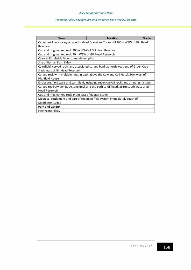
Ilkley Neighbourhood Plan
Planning Policy Background and Evidence Base Review Update
158 February 2017
Name Location Grade
Carved rock in a valley on south side of Cranshaw Thorn Hill 460m WSW of Gill Head Reservoir
Cup and ring marked rock 300m NNW of Gill Head Reservoir
Cup and ring marked rock 90m WSW of Gill Head Reservoir
Cairn at Rombalds Moor triangulation pillar
Site of Roman Fort, Ilkley
Cairnfield, carved rocks and associated curved bank at north west end of Green Crag Slack, east of Gill Head Reservoir
Carved rock with multiple rings in path above the Cow and Calf Hotel180m west of Highfield House
Enclosure, field walls and cairnfield, including seven carved rocks and an upright stone
Carved roc between Backstone Beck and the path to Gillhead, 365m south west of Gill Head Reservoir
Cup and ring marked rock 340m east of Badger Stone
Medieval settlement and part of the open field system immediately south of Myddleton Lodge
Park and Garden
Heathcote, Ilkley

Ilkley Neighbourhood Plan
Planning Policy Background and Evidence Base Review Update
159 February 2017
7.0 Conclusion
Neighbourhood Plans are required to sit within the framework of national,
regional and local planning policies, and to be in general conformity with
those policies. The information provided in this document sets out the
planning policy context, within which the Ilkley Neighbourhood Plan should
be prepared.
It is important to note that the document is a “live” document in that it will
require regular reviewing and updating to ensure that it takes account of
changes to emerging plans as they move forward towards adoption, and that
it reflects other planning policy documents as and when they are published.
The planning policy background will therefore be reviewed before
consultation on the Draft Plan, and at the point of submission of the final
version to Bradford Council.

Ilkley Neighbourhood Plan
Planning Policy Background and Evidence Base Review Update
160 February 2017

Ilkley Neighbourhood Plan
Planning Policy Background and Evidence Base Review Update
161 February 2017
Ilkley Neighbourhood Plan
Planning Policy Background and Evidence Base Review Update
162 February 2017