Wagga Wagga Planning Study · Eco Logical Australia Pty Ltd has been commissioned by Wagga Wagga...
26
ABN 87 096 512 088 | address Suite 4 2-4 Merton Street Sutherland NSW 2232 postal PO Box 12 Sutherland NSW 1499 | phone 02 8536 8600 | fax 02 9542 5622 web www.ecoaus.com.au Wagga Wagga Planning Study Bushfire Risk Management Study for the Bomen Site FINAL (Project No. 088 – 002) Report prepared for: Willana Associates on behalf of Wagga Wagga City Council March 2008 ASSESSMENT | PLANNING | MANAGEMENT
Transcript of Wagga Wagga Planning Study · Eco Logical Australia Pty Ltd has been commissioned by Wagga Wagga...
ABN 87 096 512 088 | address Suite 4 2-4 Merton Street Sutherland NSW 2232
postal PO Box 12 Sutherland NSW 1499 | phone 02 8536 8600 | fax 02 9542 5622 web www.ecoaus.com.au
Wagga Wagga Planning Study
Bushfire Risk Management Study
for the Bomen Site
FINAL
(Project No. 088 – 002)
Report prepared for: Willana Associates
on behalf of Wagga Wagga City Council
March 2008
ASSESSMENT | PLANNING | MANAGEMENT
Wagga Wagga Planning Study: Bushfire-Bomen Site
i Eco Logical Australia Pty Ltd Ph - (02) 8536 8600 Ecological Assessment, GIS, Environmental Management and Planning Fax - (02) 9542 5622
Document Tracking
Item Detail Signature
Project Name Wagga Wagga Planning Study: Bushfire Risk Management Study
Subject Site Bomen
Project Number 088-002
Prepared by NK
Prepared by AP
Prepared by PC
Approved by SH
Status Final
Version Number 1
File location G:\Current_Projects\Councils\Wagga\Wagga Planning Studies-Bushfire Risk Assessment\reports\Wagga bushfire template.doc
Date 5th March 2008
Acknowledgements This document has been prepared by Eco Logical Australia Pty Ltd with support from Willana Associates. The study team would like to thank Wagga Wagga Council staff for their assistance in providing relevant information for this report.
Disclaimer This document may only be used for the purpose for which it was commissioned and in accordance with the contract between Eco Logical Australia Pty Ltd and Wagga Wagga City Council. The scope of services was defined in consultation with the client, by time and budgetary constraints imposed by the client, and the availability of reports and other data. Changes to available information, legislation and schedules are made on an ongoing basis and readers should obtain up to date information. Eco Logical Australia Pty Ltd accepts no liability or responsibility whatsoever for or in respect of any use of or reliance upon this report and its supporting material by any third party. Information provided is not intended to be a substitute for site specific assessment or legal advice in relation to any matter. Unauthorised use of this report in any form is prohibited.
Wagga Wagga Planning Study: Bushfire-Bomen Site
ii Eco Logical Australia Pty Ltd Ph - (02) 8536 8600 Ecological Assessment, GIS, Environmental Management and Planning Fax - (02) 9542 5622
Executive Summary
This report considers the bushfire hazard located across the Bomen site and identifies any limitations to development, integrated bushfire and environmental management actions as well as the location and adequacy of emergency response facilities. The bushfire hazard across the site is generally considered to be low, reflecting the flat topology across the majority of the site and low fuel accumulation levels associated with the grassy woodland vegetation that is prevalent. This report has demonstrated that development at the subject site can meet the requirements of Planning for Bushfire Protection (NSW RFS 2006) given the incorporation of a number of strategies designed to minimise the risk from bushfire. Asset Protections Zones (APZ) are a key component of bushfire planning and the issue which often has the greatest impact on development yields. Residential APZs have been addressed, as a guide for industrial development, according to the specifications contained within Planning for Bushfire Protection 2006 (NSW RFS 2006). Generally speaking, an APZ of 15 metres is likely to be required adjacent to bushfire prone vegetation across the majority of the site. For a variety of reasons, the provision of a perimeter road is deemed essential and it is anticipated that in most situations such APZs can be wholly contained within the perimeter road easement and standard setbacks (6 metres). Therefore, for urban design inputs, it is likely that provision of an adequate perimeter road system will meet setback, access and egress requirements. Water supply is to be via a ring main system, engineered to the requirements of AS 2419.1-1994 Fire Hydrant Installations (SAI Global, 1994). With regards to construction, later stages of site development will need to consider the requirements of Appendix 3 of PBP 2006). Specifications for management of ecological bushfire regimes have also been provided, emphasising the need to implement regimes consistent with the Bushfire Environmental Assessment Code (RFS 2006a). Finally, Council should undertake consultation with the NSW Rural Fire Service (RFS) and NSW Fire Brigades (NSW FB) when the draft LEP is finalised. The purpose of this consultation is to advise the RFS and NSW FB of the proposed land use changes, to discuss any operational changes required due to this change in land use (including additional emergency resources that may be required) and to discuss how the site can meet the requirements of Planning for Bushfire Protection (NSW RFS 2006). In addition, Council will need to review its bushfire prone land mapping (NSW RFS 2003) with regard to land use changes and also incorporating “environmental lands” or other areas that may pose a threat into the future (if not already).
Wagga Wagga Planning Study: Bushfire-Bomen Site
iii Eco Logical Australia Pty Ltd Ph - (02) 8536 8600 Ecological Assessment, GIS, Environmental Management and Planning Fax - (02) 9542 5622
Contents
EXECUTIVE SUMMARY............................................................................................................................ II
1. INTRODUCTION.............................................................................................................................. 4
1.1 BACKGROUND ................................................................................................................................4 1.2 AIMS AND STRUCTURE OF REPORT.....................................................................................................4 1.3 STUDY AREA ....................................................................................................................................5 1.4 LEGISLATIVE REQUIREMENTS ..............................................................................................................5 1.4.1 Environmental Planning and Assessment Act 1979........................................................5 1.4.2 Threatened Species Conservation Act 1995 ...................................................................5 1.4.3 Rural Fires Act, 1997 ..............................................................................................................6
2. BUSHFIRE HAZARD ASSESSMENT................................................................................................... 7
3. PLANNING FOR BUSHFIRE PROTECTION (2006) ASSESSMENT .................................................... 9
3.1 ASSET PROTECTION ZONES (APZS) ...................................................................................................9 3.2 EMERGENCY ACCESS/EGRESS .......................................................................................................10 3.3 WATER SUPPLY ..............................................................................................................................11 3.4 CONSTRUCTION STANDARDS ..........................................................................................................12 3.5 INFRASTRUCTURE ............................................................................................................................12
4. MANAGEMENT............................................................................................................................. 13
4.1 ASSET PROTECTION ZONES .............................................................................................................13 4.2 PROTECTED VEGETATION ...............................................................................................................13 4.2.1 Fire Frequency .....................................................................................................................14 4.2.2 Fire Seasonality ....................................................................................................................14 4.2.3 Fire Intensity..........................................................................................................................14
5. EMERGENCY RESPONSE.............................................................................................................. 15
6. PLANNING CONTROLS ................................................................................................................ 17
7. DEVELOPMENT STAGING ............................................................................................................ 19
8. CONCLUSIONS ............................................................................................................................ 20
9. REFERENCES ................................................................................................................................. 22
APPENDIX 1 – PBP 2006 PERIMETER ROAD SPECIFICATIONS ............................................................ 23
APPENDIX 2 - INITIAL LAND USE MAP................................................................................................. 25

Wagga Wagga Planning Study: Bushfire-Bomen Site
4 Eco Logical Australia Pty Ltd Ph - (02) 8536 8600 Ecological Assessment, GIS, Environmental Management and Planning Fax - (02) 9542 5622
1. Introduction
1.1 Background
Wagga Wagga City Council (WWCC) is in the process of preparing a draft Local Environment Plan (LEP) for the Wagga Wagga Local Government Area (WWLGA). The draft plan is intended to implement the strategic planning undertaken in the Wagga Wagga Spatial Plan 2007 (WWCC 2006) and will be prepared in accordance with the Standard Instrument (Local Environmental Plans) Order 2006. Preparation of the draft LEP requires that 8 bushfire risk management studies be undertaken at sites within the WWLGA that are proposed to be subject to significant zoning changes. These sites are:
• Boorooma East • Estella West • Lloyd • Bomen • Eastern Industrial – Copland Street South • Eastern Industrial – Hammond Avenue North • Edison Road • Moorong Street
Eco Logical Australia Pty Ltd has been commissioned by Wagga Wagga City Council to undertake an assessment of the bushfire hazards and planning requirements for each of the above sites. This document presents the bushfire report for the proposed development site known as Bomen. Similar reports for each of the 7 additional development sites are presented as separate documents.
1.2 Aims and Structure of Report
This report aims to identify potential bushfire constraints to future development of the site. The objectives of the report are to:
1. Ensure statutory requirements for bushfire protection are met; and 2. Achieve innovative management frameworks across bushfire and vegetation
issues which enable long term conservation and management of these issues while facilitating development outcomes for the site.
The report assesses the potential bushfire hazard across the site, in the context of existing remnant vegetation as well as the potential for revegetation. It then identifies planning requirements as per Planning for Bushfire Protection 2006 (NSW RFS 2006). Management of Asset Protection Zones (APZ) and environmental areas are considered. The location of emergency response facilities is mapped and the potential for future emergency response resources is discussed. Potential planning controls that integrate with Planning for Bushfire Protection 2006 are also presented as are requirements for staged development.
Wagga Wagga Planning Study: Bushfire-Bomen Site
5 Eco Logical Australia Pty Ltd Ph - (02) 8536 8600 Ecological Assessment, GIS, Environmental Management and Planning Fax - (02) 9542 5622
1.3 Study Area
The Bomen site occurs approximately 4 km to the north east of the city of Wagga Wagga. The site occupies an area of approximately 2821 ha and is bound by the Olympic Highway to the west, Mary Gilmore Road and Byrnes Road to the north, and Baven Road to the south. The Main Southern Railway Line and Byrnes Road run in a north to south direction and dissect the site. Current land use at the site is predominately rural with much of the site consisting of improved pasture, sparsely grazed by sheep and cattle, or cropped land. Industrial development occurs in the south of the site, along with livestock sale yards and a sewerage treatment plant (STP). The topography of the site is gently undulating with some steeper, hilly areas represented by two higher peaks (approximately 260 and 280 metres above sea level) in the south east of the site. The elevation ranges from these high points to a low of approximately 180 metres ASL on the east of the site. Ponded surface water is provided on the site by numerous farm dams along with settlement and evaporation ponds associated with Riverina Wool Combing Pty Ltd and the stormwater treatment plant east of the Olympic Highway. The study site is mostly devoid of native vegetation with improved pasture and cropping (e.g. canola and barley) occupying most of the site. Native vegetation is confined to isolated paddock trees and remnant roadside vegetation with the most notable stands of vegetation located along Byrnes and Trahairs Roads.
1.4 Legislative Requirements
1.4.1 Environmental Planning and Assessment Act 1979
The NSW Environmental Planning and Assessment Act 1979 (EP&A Act) is the principal planning legislation for the state, providing a framework for the overall environmental planning and assessment of development proposals. Various legislation and instruments, such as the NSW Threatened Species Conservation Act 1995 (TSC Act), are integrated with the EP&A Act.
1.4.2 Threatened Species Conservation Act 1995
The Threatened Species Conservation Act 1995 (TSC Act) aims to protect and encourage the recovery of threatened species, populations and communities listed under the Act. The TSC Act is integrated with the EP&A Act and requires consideration of whether a development (Part 4 of the EP&A Act 1974) is likely to significantly affect threatened species, populations and ecological communities or their habitat. In relation to bushfire, the TSC Act also identifies high frequency fire regimes as a key threatening process.
Wagga Wagga Planning Study: Bushfire-Bomen Site
6 Eco Logical Australia Pty Ltd Ph - (02) 8536 8600 Ecological Assessment, GIS, Environmental Management and Planning Fax - (02) 9542 5622
1.4.3 Rural Fires Act, 1997
Bushfire issues are regulated by the Rural Fires Act, 1997 (RF Act). Both the EP&A Act and the RF Act were modified by the Rural Fires and Environmental Assessment Legislation Amendment Act, 2002. LEP requirements in relation to bushfire are identified through Direction 19, under Section 117 of the RF Act. This direction effectively points to the need to satisfy the requirements of Planning for Bushfire Protection (NSW RFS, 2001). Following from the current rezoning study, when development proceeds it will either be assessed under 79BA of the EPA Act or 100B of the RF Act. As this development concerns industrial development it is covered under 79BA of the EPA Act The document Planning for Bushfire Protection (NSW RFS, 2006) identifies the key criteria that need to be addressed in bushfire planning. These are also the key criteria upon which the RFS determine if a Bushfire Safety Authority will be issued.
Wagga Wagga Planning Study: Bushfire-Bomen Site
7 Eco Logical Australia Pty Ltd Ph - (02) 8536 8600 Ecological Assessment, GIS, Environmental Management and Planning Fax - (02) 9542 5622
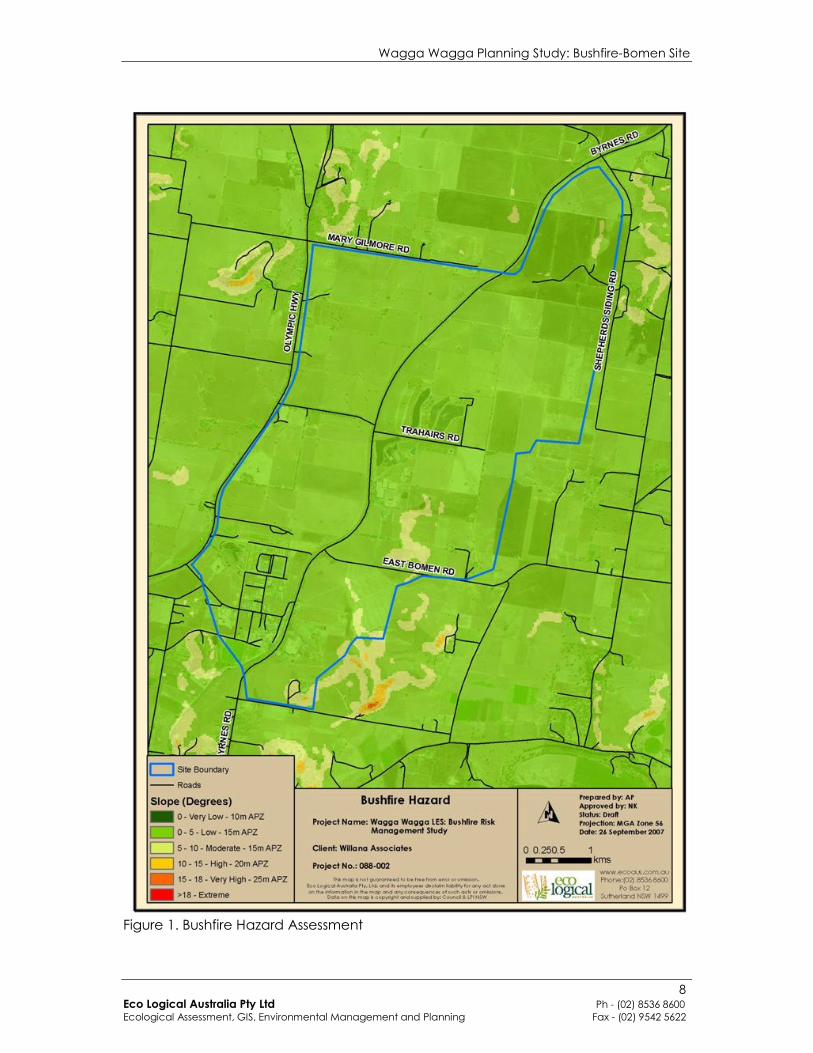
2. Bushfire Hazard Assessment
The bushfire hazard was assessed for at least a distance of 140m from the subject site (in line with PBP, NSW RFS 2006) in order to address the potential bushfire threat from both within and outside of the site and allow for a prediction of required asset protection zones to hazards located off the subject site. The approach taken with this hazard assessment is effectively a terrain assessment as it has assumed a homogenous vegetation structure across the site (grassy woodland) – in this way it is designed to inform APZ requirements for both current and future (revegetated) vegetation. Remnant native vegetation exists as small, isolated pockets of moderate quality roadside vegetation (e.g. roadsides along Trahairs Road and Byrne’s Road) and as scattered paddock trees overlying improved pasture and cropping. Large and very large trees were scattered along road reserves across the site. In later stages of development, areas of the site may be subject to revegetation works or natural regeneration. To assist in considering the potential future hazard across the site, the entire site has been assessed as containing grassy woodland vegetation, the likely natural state of any revegetated lands. The following slope categories have been used to identify relative potential future bushfire hazard across the site (based on a woodland vegetation structure);
• 0 = very low • >0˚ – 5˚ = low • >5˚ – 10˚ = moderate • >10˚ – 15˚ = high • >15˚ – 18˚ = very high • >18˚ = extreme
When interpreting this analysis, consideration also needs to be given to the relative topographic position of bushland and development. The above categories assume that bushland is downslope from development. As fires burn much slower and at a much lower intensity when travelling down hill, where bushland is located upslope from development a ‘very low’ hazard ranking is appropriate. In comparing the assessed bushfire hazard across the site with other environments across the state the site is considered to have a low hazard rating. Figure 1 shows the relative hazard rating across the site as well as an indication of the required APZs for these areas. The majority of the site is considered to have a low bushfire hazard rating due to the low fuel accumulation associated with grassy woodland vegetation and flat topography. A few hilly areas in the south of the site are considered to have a moderate bushfire hazard rating due the steeper slopes present in that area, however this is quite restricted in size.
Wagga Wagga Planning Study: Bushfire-Bomen Site
8 Eco Logical Australia Pty Ltd Ph - (02) 8536 8600 Ecological Assessment, GIS, Environmental Management and Planning Fax - (02) 9542 5622
Figure 1. Bushfire Hazard Assessment
Wagga Wagga Planning Study: Bushfire-Bomen Site
9 Eco Logical Australia Pty Ltd Ph - (02) 8536 8600 Ecological Assessment, GIS, Environmental Management and Planning Fax - (02) 9542 5622
3. Planning for Bushfire Protection (2006) Assessment
Given that the proposed development is for commercial, employment and/or industrial uses it is classified in PBP (NSW RFS 2006) as ‘Other Development’. As such it needs to satisfy the aims and objectives of PBP and the proposal will need to incorporate these considerations along with an adequate combination of relevant bushfire protection measures (BPM). Generally, the BPMs listed in PBP (NSW RFS 2006) for residential development can be used as a guide and are discussed in the following sections. The aim and objectives of PBP (NSW RFS 2006) are as follows.
Aim of PBP
to use the NSW development assessment system to provide for the protection of human
life (including firefighters) and to minimise impacts on property from the threat of bush
fire, while having due regard to development potential, on-site amenity and protection
of the environment.
Objectives of PBP
(i) afford occupants of any building adequate protection from exposure to a bush fire;
(ii) provide for a defendable space to be located around buildings;
(iii) provide appropriate separation between a hazard and buildings which, in
combination with other measures, prevent direct flame contact and material ignition;
(iv) ensure that safe operational access and egress for emergency service personnel
and residents is available;
(v) provide for ongoing management and maintenance of bush fire protection
measures, including fuel loads in the asset protection zone (APZ); and
(vi) ensure that utility services are adequate to meet the needs of firefighters (and
others assisting in bush fire fighting).
The following key elements are required to be addressed in bushfire assessments;
1. Asset Protection Zones (APZs) 2. Emergency access/egress 3. Water supply 4. Construction standards 5. Infrastructure
3.1 Asset Protection Zones (APZs)
APZs are areas located between bushfire hazards and development to provide a defensible space in which to undertake emergency operations and to provide a buffer from direct flame contact, radiant heat, smoke and embers. The width of APZs is based on a combination of; • Vegetation structure • Slope • Topographic position (i.e. if the asset is above, or below the hazard) • Fire Danger Index (FDI) (the FDI for Wagga Wagga is 80)
Wagga Wagga Planning Study: Bushfire-Bomen Site
10 Eco Logical Australia Pty Ltd Ph - (02) 8536 8600 Ecological Assessment, GIS, Environmental Management and Planning Fax - (02) 9542 5622
As the vegetation on the site will likely be remnant and reconstructed grassy woodland communities, only vegetation of ‘Woodland’ structure is considered. APZs meeting ‘acceptable solution’ requirements are identified in Table 1 below. Under PBP 2006, APZs only comprise Inner Protection Areas (IPA). If the minimum APZs identified below are implemented, the majority of buildings immediately adjacent to the APZ will require construction to Level 3 of AS3959-1999. If lower construction standards are desirable, APZ widths should be increased beyond those shown in table 1 below. Potential ‘alternative solutions’ for APZs may include increasing construction standards of buildings or implementing appropriate fuel management regimes within vegetated areas.
Table 1: Planning for Bushfire Protection APZ Requirements for Residential Development
Slope (degrees) Residential
(metres)
Upslope/flat 10
Downslope
>0 – 5 15
>5 – 10 15
>10 - 15 20
>15 - 18 25
3.2 Emergency Access/Egress
Broadly speaking, emergency access/egress relates to the provision of a perimeter road or perimeter trail with direct access to the internal road system. Adjacent to bushfire hazards, the internal road system should be kept simple to allow for rapid access/egress in the case of a bushfire emergency and provide a system that radiates away from the bushfire hazard. Perimeter road/trail requirements are identified below and full specifications are included in Appendix 1; (i) Location: The perimeter road or fire trail often lies between (or within) the Asset Protection Zone and the boundary of the allotments. A perimeter road should be the preferred option where possible. (ii) Purpose:
• provide fire fighters with easier access to structures, allowing more efficient use of fire fighting resources;
• provide a safe retreat for fire fighters; and • provide a clear control line from which to conduct hazard reduction or back
burning operations.
Wagga Wagga Planning Study: Bushfire-Bomen Site
11 Eco Logical Australia Pty Ltd Ph - (02) 8536 8600 Ecological Assessment, GIS, Environmental Management and Planning Fax - (02) 9542 5622
(iii) Specifications: • The perimeter road should preferably provide 2 way access (carriageway 8
metres kerb to kerb). • Comply with the design specifications relating to slope, capacity etc
identified in PBP 2006 (reproduced in Appendix 1 of this report) • If a perimeter fire trail is preferred to a perimeter road, the fire trail should:
• be located within a perimeter reserve a minimum of 6m wide (4m wide trail & 1m wide cleared area each side of the trail), with the reserve maintained in accordance with the specifications for an Inner Protection Area;
• the trail should be constructed in accordance with the design criteria established in Planning for Bushfire Protection.
• the fire trail must be trafficable by fire fighting vehicles under all weather conditions;
• the fire trail should link into the street network (if applicable) at regular intervals via an access track constructed in accordance with the design criteria established in Planning for Bushfire Protection.
• the fire trail should be maintained and in a serviceable and accessible condition at all times by the owner of the land.
Should a narrower perimeter road be preferred, this may be possible subject to the provision of parking bays and placement of no stopping signs along narrower stretches, this would be considered an ‘alternative solution’ by the RFS.
3.3 Water Supply
It is recommended that water supply to the site is provided via a ring main system. The ring main system must be of sufficient pressure and fire hydrants located to comply with AS 2419.1-1994 Fire Hydrant Installations (SAI Global, 1994). There may be potential for the use of reticulated recycled water to be used for fire fighting purposes, however further consultation with the RFS will be required if reticulated recycled water becomes available within the precinct. The RFS do not currently have a formal policy relating to the use of recycled water for fire fighting activities. If water supply is non-reticulated then a dedicated static water supply reserve must be created and maintained. The quantity of water required is determined on the basis of lot size and density and is shown below.
Development Type Water Requirements
Residential Lots (<1,000m2) 5,000 l/lot
Rural-residential Lots (1,000m2 - 10,000 m2) 10,000 l/lot
Large Rural/Lifestyle Lots (>10,000m2) 20,000 l/lot
Wagga Wagga Planning Study: Bushfire-Bomen Site
12 Eco Logical Australia Pty Ltd Ph - (02) 8536 8600 Ecological Assessment, GIS, Environmental Management and Planning Fax - (02) 9542 5622
3.4 Construction Standards
Construction of new dwellings (residential) must comply with the Appendix 3 of PBP 2006 and AS3959-1999 Construction of Building in Bushfire Prone Areas (SAI Global, 1999).
The proposed development falls under classes 5 to 8 and 10 of the Building Code of Australia (BCA). These classes include: offices, factories, warehouses, public car parks and other commercial or industrial facilities. The BCA does not provide building requirements relating to bushfire threat for these classes of building. As such, general fire safety construction should be acceptable. Exceptions may apply to this when the aims and objectives of PBP (NSW RFS 2006) are not properly satisfied in relation to setback, access, water and services, emergency planning and landscaping/vegetation management. Such cases are examined on a case-by case basis by the NSW RFS (consent authority) to determine acceptable construction standards.
3.5 Infrastructure
This primarily relates to the provision of electricity and gas to the development. These should be located underground to avoid damage by bushfire. Where possible, permanent large lines and temporary 11kv lines should be placed underground.
Wagga Wagga Planning Study: Bushfire-Bomen Site
13 Eco Logical Australia Pty Ltd Ph - (02) 8536 8600 Ecological Assessment, GIS, Environmental Management and Planning Fax - (02) 9542 5622
4. Management
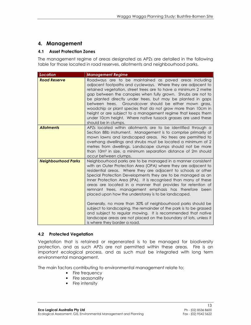
4.1 Asset Protection Zones
The management regime of areas designated as APZs are detailed in the following table for those located in road reserves, allotments and neighbourhood parks. Location Management Regime
Road Reserve Roadways are to be maintained as paved areas including adjacent footpaths and cycleways. Where they are adjacent to retained vegetation, street trees are to have a minimum 2 metre gap between the canopies when fully grown. Shrubs are not to be planted directly under trees, but may be planted in gaps between trees. Groundcover should be either mown grass, woodchip or plant species that do not grow more than 10cm in height or are subject to a management regime that keeps them under 10cm height. Where native tussock grasses are used these should be in clumps.
Allotments APZs located within allotments are to be identified through a Section 88b instrument. Management is to comprise primarily of mown lawns and landscaped areas. No trees are permitted to overhang dwellings and shrubs must be located a minimum of 2 metres from dwellings. Landscape clumps should not be more than 10m² in size, a minimum separation distance of 2m should occur between clumps.
Neighbourhood Parks Neighbourhood parks are to be managed in a manner consistent with an Outer Protection Area (OPA) where they are adjacent to residential areas. Where they are adjacent to schools or other Special Protection Developments they are to be managed as an Inner Protection Area (IPA). It is recognised than many of these areas are located in a manner that provides for retention of remnant trees, management emphasis has therefore been placed upon how the understorey is to be landscaped. Generally, no more than 30% of neighbourhood parks should be subject to landscaping, the remainder of the park is to be grassed and subject to regular mowing. It is recommended that native landscape areas are not placed on the boundary of lots, unless it is where they border a road.
4.2 Protected Vegetation
Vegetation that is retained or regenerated is to be managed for biodiversity protection, and as such APZs are not permitted within these areas. Fire is an important ecological process, and as such must be integrated with long term environmental management. The main factors contributing to environmental management relate to;
• Fire frequency • Fire seasonality • Fire intensity
Wagga Wagga Planning Study: Bushfire-Bomen Site
14 Eco Logical Australia Pty Ltd Ph - (02) 8536 8600 Ecological Assessment, GIS, Environmental Management and Planning Fax - (02) 9542 5622
It is important to ensure that fire regimes are varied spatially across the site, and temporally at any one point, the objectives being;
1. Ensuring a variety of interfire periods are present across the site 2. Ensuring that the season, intensity and frequency of burns are varied at any
one area This is referred to as mosaic management and is aimed at ensuring a diversity of life cycles are present across the site and that a homogenous fire regime is avoided that may benefit certain species at the expense of others.
4.2.1 Fire Frequency
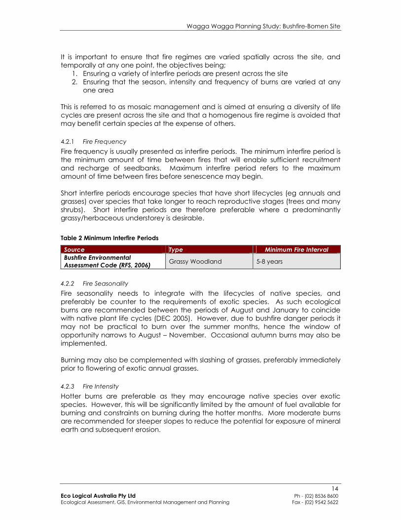
Fire frequency is usually presented as interfire periods. The minimum interfire period is the minimum amount of time between fires that will enable sufficient recruitment and recharge of seedbanks. Maximum interfire period refers to the maximum amount of time between fires before senescence may begin. Short interfire periods encourage species that have short lifecycles (eg annuals and grasses) over species that take longer to reach reproductive stages (trees and many shrubs). Short interfire periods are therefore preferable where a predominantly grassy/herbaceous understorey is desirable.
Table 2 Minimum Interfire Periods
Source Type Minimum Fire Interval
Bushfire Environmental
Assessment Code (RFS, 2006) Grassy Woodland 5-8 years
4.2.2 Fire Seasonality
Fire seasonality needs to integrate with the lifecycles of native species, and preferably be counter to the requirements of exotic species. As such ecological burns are recommended between the periods of August and January to coincide with native plant life cycles (DEC 2005). However, due to bushfire danger periods it may not be practical to burn over the summer months, hence the window of opportunity narrows to August – November. Occasional autumn burns may also be implemented. Burning may also be complemented with slashing of grasses, preferably immediately prior to flowering of exotic annual grasses.
4.2.3 Fire Intensity
Hotter burns are preferable as they may encourage native species over exotic species. However, this will be significantly limited by the amount of fuel available for burning and constraints on burning during the hotter months. More moderate burns are recommended for steeper slopes to reduce the potential for exposure of mineral earth and subsequent erosion.
Wagga Wagga Planning Study: Bushfire-Bomen Site
15 Eco Logical Australia Pty Ltd Ph - (02) 8536 8600 Ecological Assessment, GIS, Environmental Management and Planning Fax - (02) 9542 5622
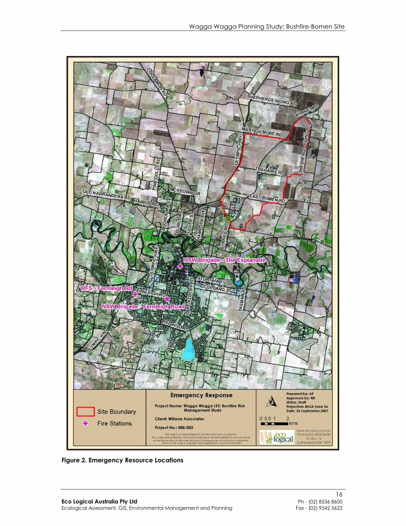
5. Emergency Response
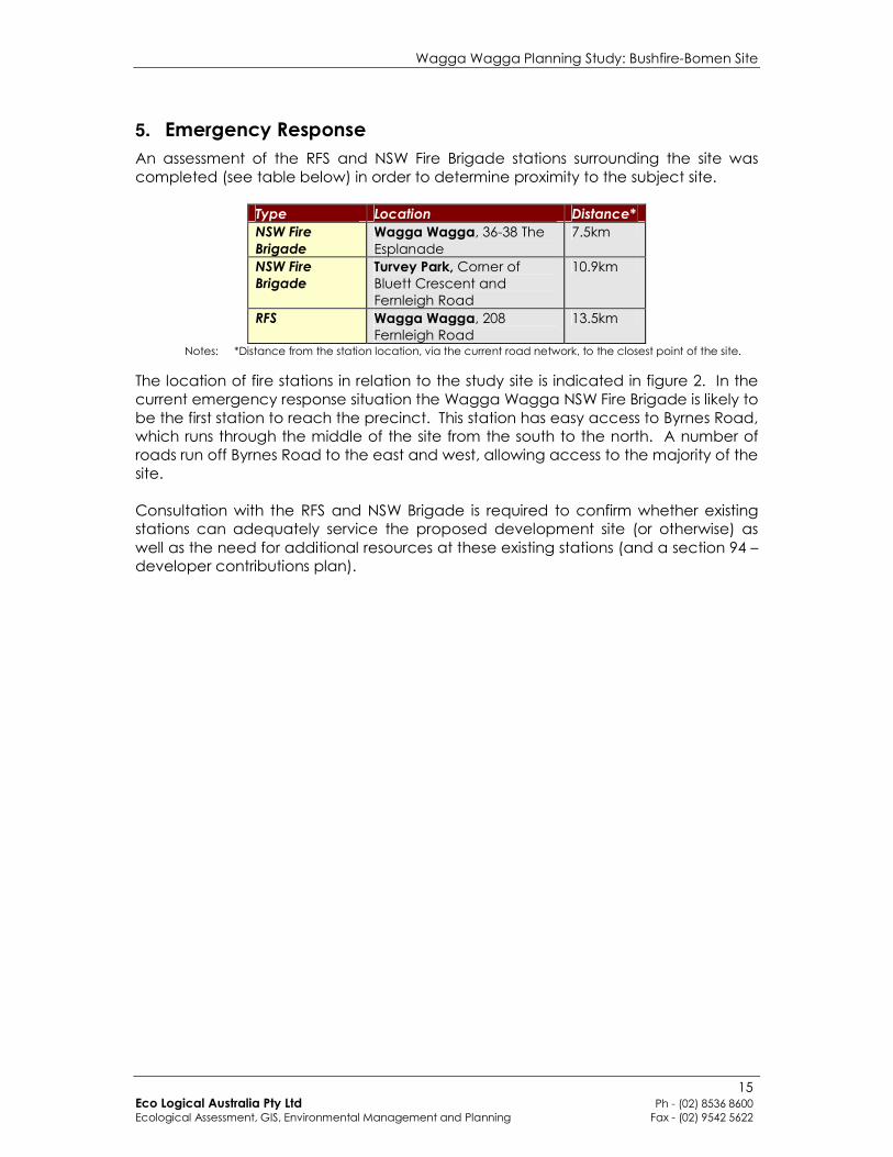
An assessment of the RFS and NSW Fire Brigade stations surrounding the site was completed (see table below) in order to determine proximity to the subject site.
Type Location Distance*
NSW Fire
Brigade
Wagga Wagga, 36-38 The Esplanade
7.5km
NSW Fire
Brigade
Turvey Park, Corner of Bluett Crescent and Fernleigh Road
10.9km
RFS Wagga Wagga, 208 Fernleigh Road
13.5km
Notes: *Distance from the station location, via the current road network, to the closest point of the site.
The location of fire stations in relation to the study site is indicated in figure 2. In the current emergency response situation the Wagga Wagga NSW Fire Brigade is likely to be the first station to reach the precinct. This station has easy access to Byrnes Road, which runs through the middle of the site from the south to the north. A number of roads run off Byrnes Road to the east and west, allowing access to the majority of the site. Consultation with the RFS and NSW Brigade is required to confirm whether existing stations can adequately service the proposed development site (or otherwise) as well as the need for additional resources at these existing stations (and a section 94 – developer contributions plan).
Wagga Wagga Planning Study: Bushfire-Bomen Site
16 Eco Logical Australia Pty Ltd Ph - (02) 8536 8600 Ecological Assessment, GIS, Environmental Management and Planning Fax - (02) 9542 5622
Figure 2. Emergency Resource Locations
Wagga Wagga Planning Study: Bushfire-Bomen Site
17 Eco Logical Australia Pty Ltd Ph - (02) 8536 8600 Ecological Assessment, GIS, Environmental Management and Planning Fax - (02) 9542 5622
6. Planning Controls
Based on the recommendations contained within PBP 2006 the following planning principles are recommended for rezoning to residential land;
1. Provision of a perimeter road with two way access which delineates the extent of the intended development;
2. Provision, at the interface, for the establishment of adequate asset protection zones for future housing;
3. Specifying minimum residential lot depths to accommodate asset protection zones for lots on perimeter roads;
4. Minimising the perimeter of the area of land, interfacing the hazard which may be developed;
5. Introduce controls which avoid placing inappropriate developments in hazardous areas; and
6. Introduce controls on the placement of combustible materials in asset protection zones.
Given that the subject site is proposed for industrial development, recommendations 2 and 5 above are seen as the most relevant. In summary:
• Ensuring adequate setbacks can be provided; • Avoiding inappropriate developments in hazardous areas such as:
o Power generating works o Sawmills o Junk Yards o Liquid fuel deposits o Offensive and hazardous industries o Chemical industries o Service stations o Ammunition storage/manufacture o Fire works manufacture/storage
PBP 2001 identifies a series of recommended clauses for inclusion in LEPs, these clauses are suitable for consideration for this study;
Objectives
• To prevent loss of life and property due to bushfires, by discouraging the establishment of incompatible uses in bushfire-prone areas • To encourage sound management of bushfire-prone areas When these principles apply
These principles will apply when a council is required to prepare an amending LEP that permits land which is bushfire-prone to be developed. Such land would be identified on council’s bushfire prone land mapping in accordance with RFS (2003). What a council should do if these principles apply
A council should not prepare the amending LEP unless it is justified by an environmental study. When preparing an environmental study, the council should consider Planning for Bushfire Protection.
Wagga Wagga Planning Study: Bushfire-Bomen Site
18 Eco Logical Australia Pty Ltd Ph - (02) 8536 8600 Ecological Assessment, GIS, Environmental Management and Planning Fax - (02) 9542 5622
If an amending LEP proposes to permit development of land which, has been found to be bushfire-prone, the plan should, as appropriate: • provide an Asset Protection Zone (APZ) incorporating at a minimum:
– an Inner Protection Area bounded by a perimeter road or reserve which circumscribes the hazard side of the land intended for development, and has a building line consistent with the incorporation of an APZ within the property – an Outer Protection Area managed for hazard reduction, and located on the bushland side of the perimeter road
• contain provisions for two way access which links to the road or fire trail network • minimise the perimeter of the area of land, interfacing the hazard, which may be developed • introduce controls which avoid placing inappropriate developments in hazardous areas • introduce controls on the placement of combustible materials within the Inner Protection Area The NSW Rural Fire Service should be consulted in the preparation of the LEP which affects a bushfire-prone area. Suggested Clause
The following extract from Shoalhaven Council LEP, 1985 demonstrates how bushfire protection provisions can be incorporated into LEPs: Sub-Clause (1) In deciding whether to grant consent to any development on land which in its opinion is likely to be affected by bushfire, the Council must take into account whether:
a) the development is likely to have a significant adverse effect on the implementation of any strategies for bushfire control and fuel management adopted by council; b) a significant threat to the lives of residents, visitors or emergency services personnel may be created or increased as a result of the development or the access arrangements to and from the development; c) the increased demand for emergency services during bushfire events created by the development would lead to a significant decrease in the ability of the emergency services personnel to effectively control major bushfires; and; d) the measures adopted to avoid or mitigate the threat from bushfire, including siting of the development, design of structures and materials used, clearing of vegetation, fuel free and fuel reduced areas and landscaping and fire control aids such as roads and water supplies are inadequate for the locality or would result in unacceptable environmental impacts.
Sub-Clause (2) In exercising its consideration of sub-clause (1), the council shall have regard to, and as much as possible, be satisfied that the provisions of Planning for Bushfire Protection, as produced by the NSW Rural Fire Service, have been met.
Wagga Wagga Planning Study: Bushfire-Bomen Site
19 Eco Logical Australia Pty Ltd Ph - (02) 8536 8600 Ecological Assessment, GIS, Environmental Management and Planning Fax - (02) 9542 5622
7. Development Staging
The staging of the development should be considered from a bushfire perspective such as to minimise the risks to the development during construction. Ideally, lots fronting the bushland interface would be developed first and APZs established upfront. Notwithstanding the above, temporary APZs should be established around each stage of the development and identified in a section 88b instrument, which would then cease once the adjacent stage of the development is undertaken. APZ widths could be identified on a site basis, based on the hazard assessment map (figure 1) which corresponds directly with the APZ categories identified in Table 1. Where bushland is located upslope from developments, an APZ of 10 metres should be applied. As the bushfire hazard will change during various stages of development, due to the creation of new vegetation, removal of old vegetation and creation of new lots, ‘Bushfire Prone Area’ mapping (BPA mapping), the trigger for assessment under the EP&A Act and the RF Act will also change. It is recommended that Council review BPA mapping following development stages.
Wagga Wagga Planning Study: Bushfire-Bomen Site
20 Eco Logical Australia Pty Ltd Ph - (02) 8536 8600 Ecological Assessment, GIS, Environmental Management and Planning Fax - (02) 9542 5622
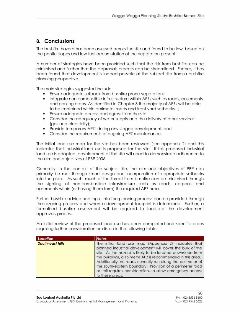
8. Conclusions
The bushfire hazard has been assessed across the site and found to be low, based on the gentle slopes and low fuel accumulation of the vegetation present. A number of strategies have been provided such that the risk from bushfire can be minimised and further that the approvals process can be streamlined. Further, it has been found that development is indeed possible at the subject site from a bushfire planning perspective. The main strategies suggested include:
• Ensure adequate setback from bushfire prone vegetation; • Integrate non combustible infrastructure within APZs such as roads, easements
and parking areas. As identified in Chapter 3 the majority of APZs will be able to be contained within perimeter roads and front yard setbacks. ;
• Ensure adequate access and egress from the site; • Consider the adequacy of water supply and the delivery of other services
(gas and electricity); • Provide temporary APZs during any staged development; and • Consider the requirements of ongoing APZ maintenance.
The initial land use map for the site has been reviewed (see appendix 2) and this indicates that industrial land use is proposed for the site. If this proposed industrial land use is adopted, development at the site will need to demonstrate adherence to the aim and objectives of PBP 2006. Generally, in the context of the subject site, the aim and objectives of PBP can primarily be met through smart design and incorporation of appropriate setbacks into the plans. As such, much of the threat from bushfire can be minimised through the sighting of non-combustible infrastructure such as roads, carparks and easements within (or having them form) the required APZ area. Further bushfire advice and input into the planning process can be provided through the rezoning process and when a development footprint is determined. Further, a formalised bushfire assessment will be required to facilitate the development approvals process. An initial review of the proposed land use has been completed and specific areas requiring further consideration are listed in the following table. Location Notes
South-east hills The initial land use map (Appendix 2) indicates that planned industrial development will cover the bulk of the site. As the hazard is likely to be located downslope from the buildings, a 15 metre APZ is recommended in this area. Additionally, no roads currently run along the perimeter of the south-eastern boundary. Provision of a perimeter road or trail requires consideration, to allow emergency access to these areas.
Wagga Wagga Planning Study: Bushfire-Bomen Site
21 Eco Logical Australia Pty Ltd Ph - (02) 8536 8600 Ecological Assessment, GIS, Environmental Management and Planning Fax - (02) 9542 5622
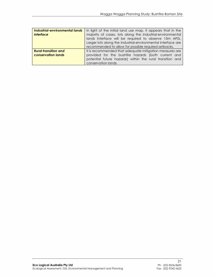
Industrial-environmental lands
interface
In light of the initial land use map, it appears that in the majority of cases, lots along the industrial-environmental lands interface will be required to observe 15m APZs. Larger lots along the industrial-environmental interface are recommended to allow for possible required setbacks.
Rural transition and
conservation lands
It is recommended that adequate mitigation measures are provided for the bushfire hazards (both current and potential future hazards) within the rural transition and conservation lands.

Wagga Wagga Planning Study: Bushfire-Bomen Site
22 Eco Logical Australia Pty Ltd Ph - (02) 8536 8600 Ecological Assessment, GIS, Environmental Management and Planning Fax - (02) 9542 5622
9. References
(DEC) Department of Environment and Conservation (NSW) 2005. Recovering Bushland on the Cumberland Plain: Best practice guidelines for the management and restoration of bushland. Department of Environment and Conservation (NSW), Sydney. NSW RFS, 2001. Planning for Bushfire Protection. A guide for Councils, Planners, Fire Authorities, Developers and Home Owners.
NSW RFS, 2003. Guideline for Bush Fire Prone Land Mapping. Version 3. Unpublished report. NSW Rural Fire Service. NSW RFS, 2006. Planning for Bushfire Protection. A guide for Councils, Planners, Fire Authorities and Developers.
SAI Global (1994). AS 2419.1-1994 Fire Hydrant Installations SAI Global (1999). AS3959-1999 Construction of Building in Bushfire Prone Areas Urban Concepts (1995). WISDOM Study – Section 5 Environmental Audit. An unpublished report prepared for the NSW Dept. of Business and Regional Development and Wagga Wagga City Council.
Wagga Wagga Planning Study: Bushfire-Bomen Site
23 Eco Logical Australia Pty Ltd Ph - (02) 8536 8600 Ecological Assessment, GIS, Environmental Management and Planning Fax - (02) 9542 5622
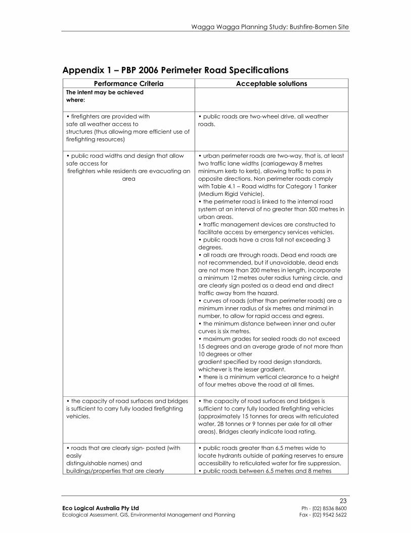
Appendix 1 – PBP 2006 Perimeter Road Specifications
Performance Criteria Acceptable solutions The intent may be achieved
where:
• firefighters are provided with
safe all weather access to
structures (thus allowing more efficient use of
firefighting resources)
• public roads are two-wheel drive, all weather
roads.
• public road widths and design that allow
safe access for
firefighters while residents are evacuating an
area
• urban perimeter roads are two-way, that is, at least
two traffic lane widths (carriageway 8 metres
minimum kerb to kerb), allowing traffic to pass in
opposite directions. Non perimeter roads comply
with Table 4.1 – Road widths for Category 1 Tanker
(Medium Rigid Vehicle).
• the perimeter road is linked to the internal road
system at an interval of no greater than 500 metres in
urban areas.
• traffic management devices are constructed to
facilitate access by emergency services vehicles.
• public roads have a cross fall not exceeding 3
degrees.
• all roads are through roads. Dead end roads are
not recommended, but if unavoidable, dead ends
are not more than 200 metres in length, incorporate
a minimum 12 metres outer radius turning circle, and
are clearly sign posted as a dead end and direct
traffic away from the hazard.
• curves of roads (other than perimeter roads) are a
minimum inner radius of six metres and minimal in
number, to allow for rapid access and egress.
• the minimum distance between inner and outer
curves is six metres.
• maximum grades for sealed roads do not exceed
15 degrees and an average grade of not more than
10 degrees or other
gradient specified by road design standards,
whichever is the lesser gradient.
• there is a minimum vertical clearance to a height
of four metres above the road at all times.
• the capacity of road surfaces and bridges
is sufficient to carry fully loaded firefighting
vehicles.
• the capacity of road surfaces and bridges is
sufficient to carry fully loaded firefighting vehicles
(approximately 15 tonnes for areas with reticulated
water, 28 tonnes or 9 tonnes per axle for all other
areas). Bridges clearly indicate load rating.
• roads that are clearly sign- posted (with
easily
distinguishable names) and
buildings/properties that are clearly
• public roads greater than 6.5 metres wide to
locate hydrants outside of parking reserves to ensure
accessibility to reticulated water for fire suppression.
• public roads between 6.5 metres and 8 metres
Wagga Wagga Planning Study: Bushfire-Bomen Site
24 Eco Logical Australia Pty Ltd Ph - (02) 8536 8600 Ecological Assessment, GIS, Environmental Management and Planning Fax - (02) 9542 5622
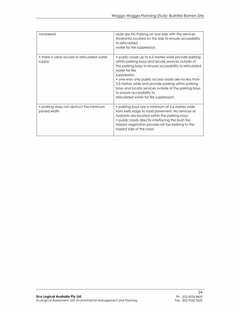
numbered.
wide are No Parking on one side with the services
(hydrants) located on this side to ensure accessibility
to reticulated
water for fire suppression.
• there is clear access to reticulated water
supply
• public roads up to 6.5 metres wide provide parking
within parking bays and locate services outside of
the parking bays to ensure accessibility to reticulated
water for fire
suppression.
• one way only public access roads are no less than
3.5 metres wide and provide parking within parking
bays and locate services outside of the parking bays
to ensure accessibility to
reticulated water for fire suppression.
• parking does not obstruct the minimum
paved width
• parking bays are a minimum of 2.6 metres wide
from kerb edge to road pavement. No services or
hydrants are located within the parking bays.
• public roads directly interfacing the bush fire
hazard vegetation provide roll top kerbing to the
hazard side of the road.

Wagga Wagga Planning Study: Bushfire-Bomen Site
25 Eco Logical Australia Pty Ltd Ph - (02) 8536 8600 Ecological Assessment, GIS, Environmental Management and Planning Fax - (02) 9542 5622
Appendix 2 - Initial Land Use Map