Arequipa ITRF co-location surveyitrf.ensg.ign.fr/doc_ITRF/RT186_V1_DONAL_ArequipaITRF-2013.pdf ·...
78
SERVICE DE GEODESIE ET NIVELLEMENT Thomas Donal Arequipa ITRF co-location survey January 2013 DIFFUSION OUVERTE N° archive Date de création N° de version RT/G 186 28492 01/07/2014 1 IGN ● Service de Géodésie et Nivellement, 73 avenue de Paris, 94165 Saint‐Mandé Cedex ● Tél : 01 43 98 83 25 ● [email protected]
Transcript of Arequipa ITRF co-location surveyitrf.ensg.ign.fr/doc_ITRF/RT186_V1_DONAL_ArequipaITRF-2013.pdf ·...
SERVICE
DE GEODESIE
ET NIVELLEMENT
Thomas Donal
Arequipa ITRF co-location survey
January 2013
DIFFUSION OUVERTE
N° archive
Date de création
N° de version
RT/G 186
28492
01/07/2014
1
IGN ● Service de Géodésie et Nivellement, 73 avenue de Paris, 94165 Saint‐Mandé Cedex ● Tél : 01 43 98 83 25 ● [email protected]
IGNService
de Géodésieet Nivellement
Thomas DONAL RT/Gv
page
1861
2/78Arequipa ITRF co-location survey
Mots-clé
Rattachement ; ITRF ; SLR ; DORIS ; GNSS ; REGINA ; Arequipa ; Pérou
Résumé
L’ITRF2008 (dernière réalisation de l’International Terrestrial Reference System) menée par le Laboratoire
de Recherche en Géodésie (LAREG) de l’IGN est le résultat de la combinaison des référentiels terrestres
issus des quatre techniques de géodésie spatiale (c’est à dire GNSS, SLR, DORIS et VLBI). Un moyen
d’améliorer les réalisations consiste à ajouter dans la combinaison les résultats de rattachement sur des sites
co-localisés. Le site d'Arequipa (Pérou) dispose d’une station SLR, d'une station DORIS et de deux stations
GNSS permanentes, intégrées dans le réseau de l’IGS. Le présent rapport décrit le rattachement de précision
réalisé en janvier 2013 sur ce site suite à l'installation d'une station GNSS REGINA
Matériel
Système d’exploitation Logiciel
Windows LibreOffice Writer 4.1.4.2
Validation
Fonction Nom Visa
Commanditaire Chef de département RSI Bruno Garayt 29/08/2014 – signé
Rédacteur Technicien d'études Thomas Donal 11/07/2014 – signé
Lecteur Responsable SIRS DORIS Jérôme Saunier 21/07/2014 – signé
Approbateur Chef de service Thierry Person 07/09/2014 – signé
Vérificateur Responsable qualité Thierry Person 18/01/2015 – signé
IGN ● Service de Géodésie et Nivellement, 73 avenue de Paris, 94165 Saint‐Mandé Cedex ● Tél : 01 43 98 83 25 ● [email protected]

IGNService
de Géodésieet Nivellement
Thomas DONAL RT/Gv
page
1861
3/78Arequipa ITRF co-location survey
Diffusion
Organisme / Service Fonction / Nom Numérique Papier
IGN / DPR Directeur / Philippe Gerbe oui -
IGN / DPR Directeur adjoint / Didier Moisset oui -
IGN / DPC / SP / CKP Chargé MO géodésie / François Becirspahic oui -
IGN / DRE/ SMGI / CDOS Chef du CDoS / Anne Berry oui -
IGN / DRE / SRIG / LAREG Chef de laboratoire / Olivier Jamet oui -
IGN / DRE / DE / DPTS Chef de département / Serge Botton oui -
IGN / DPR / SGN Chef de service / Alain Harmel oui -
IGN / DPR / SGN Responsable qualité / Thierry Person oui -
IGN / DPR / SGN / PMC Responsable documentation / Xavier della Chiesa non 3
IGN / DPR / SGN / PMT Responsable produits / François L’Ecu oui -
IGN / DPR / SGN Chefs de départements oui -
IGN / DPR / SGN / PMM Thomas Donal oui 1
IGN / DPR / SGN / PMM Bruno Garayt oui 1
IGN / DPR / SGN / PMM Jérôme Saunier oui -
IGN / DPR / SGN / PMM Charles Velut oui -
IGN / DPR / SGN / PMM Jean-Claude Poyard oui -
IGN / DRE / SRIG / LAREG Zuheir Altamimi oui 1
IGN / DRE / SRIG / LAREG Xavier Collilieux oui -
CNES / DCT / ME / NC Alain Brissaud oui -
CNES / DCT / ME / OT Thierry Guinle oui -
CNES / DCT / ME / OT Cédric Tourain oui 1
CNES / DCT / ME / OT François Boldo oui 1
NASA David McCormick oui -
NASA James Long oui -
UNSA Pablo Raul Yanyachi oui -
IGN / DPR / SGN / PMM Archives DORIS oui 1
CNES [email protected] oui -
IGN [email protected] oui -
IGN [email protected] oui -
IGN itrf.ign.fr oui -
IGN ● Service de Géodésie et Nivellement, 73 avenue de Paris, 94165 Saint‐Mandé Cedex ● Tél : 01 43 98 83 25 ● [email protected]
IGNService
de Géodésieet Nivellement
Thomas DONAL RT/Gv
page
1861
4/78Arequipa ITRF co-location survey
Table of contents
1. Introduction................................................................................................................51.1. Subject......................................................................................................................................51.2. Glossary.....................................................................................................................................5
2. Co‐location site description.........................................................................................72.1. Site description.........................................................................................................................72.2. Co‐located points ...................................................................................................................10
2.2.1. GPS station – AREQ.......................................................................................................................102.2.2. GNSS station – AREG.....................................................................................................................112.2.3. DORIS station – ARFB....................................................................................................................122.2.4. SLR telescope – AREL....................................................................................................................132.2.5. Geodetic benchmarks...................................................................................................................152.2.6. Calibration piers............................................................................................................................17
2.3. Site sketch...............................................................................................................................19
3. Survey description.....................................................................................................213.1. Organization............................................................................................................................213.2. Equipment...............................................................................................................................21
3.2.1. GNSS REGINA permanent station.................................................................................................213.2.2. Survey instruments.......................................................................................................................213.2.3. Survey accessories........................................................................................................................22
3.3. Polygon network.....................................................................................................................233.4. Survey method........................................................................................................................25
3.4.1. Permanent stations reference point............................................................................................253.4.2. GNSS observations........................................................................................................................27
4. Computation.............................................................................................................284.1. GNSS network.........................................................................................................................284.2. Global adjustment..................................................................................................................28
5. Results.......................................................................................................................295.1. Station name translation table...............................................................................................295.2. Adjusted coordinates and confidence regions.......................................................................30
6. Appendixes................................................................................................................326.1. « ARFB » DORIS station site log..............................................................................................326.2. « AREQ » GNSS station site log (extract)................................................................................366.3. « AREG » GNSS station site log...............................................................................................416.4. « AREL » SLR station site log (extract)....................................................................................476.5. Leica Geo Office report file.....................................................................................................526.6. Adjustment input file..............................................................................................................546.7. Adjustement output file.........................................................................................................636.8. Arequipa SINEX file.................................................................................................................78
IGN ● Service de Géodésie et Nivellement, 73 avenue de Paris, 94165 Saint‐Mandé Cedex ● Tél : 01 43 98 83 25 ● [email protected]
IGNService
de Géodésieet Nivellement
Thomas DONAL RT/Gv
page
1861
5/78Arequipa ITRF co-location survey
1. Introduction
1.1. Subject
The International Terrestrial Reference Frame (ITRF) is the result of a combination ofdifferent terrestrial reference frames provided by the four space geodetic techniques:
-Very Long Baseline Interferometry (VLBI)-Satellite Laser Ranging (SLR)-Global Navigation Satellite System (GNSS)-Doppler Orbitography and Radiopositioning Integrated by Satellite (DORIS)
To perform this combination between independent reference frames, it is necessary to havesome co-location sites where the various techniques are operating, from which tie vectorsbetween their reference points have been surveyed in three dimensions.
The local ties survey accuracy as stated by GGOS should reach 1 mm.
As far as a REGINA or DORIS site is co-located, a local tie is carried out by IGN with thetriple purpose:
→ assign coordinates to new instruments reference points;→ provide tie vectors between instruments reference points (i.e. DORIS, GNSS,
SLR, VLBI, tide gauge);→ produce a local tie SINEX file to LAREG
This document presents the local tie survey at Arequipa (Peru), which took place in January2013 within the framework of the REGINA station installation.
1.2. Glossary
CDP : Crustal Dynamics ProjectCNES : Centre National d’Études Spatiales (France)DOMES : Directory of MERIT SitesDORIS : Détermination d'Orbite et Radio positionnement Intégré par SatelliteGNSS : Global Navigation Satellite SystemIDS : International DORIS ServiceILRS : International Laser Ranging ServiceIGN : Institut National de l'Information Géographique et Forestière (France)IGS : International GNSS ServiceNASA : National Aeronautics and Space Administration (USA)REGINA : REseau Gnss pour l'IGS et la NAvigationSLR : Satellite Laser RangingSINEX : Solution INdependent EXchangeUNSA : Universidad Nacional de San Agustin (Peru)
IGN ● Service de Géodésie et Nivellement, 73 avenue de Paris, 94165 Saint‐Mandé Cedex ● Tél : 01 43 98 83 25 ● [email protected]
IGNService
de Géodésieet Nivellement
Thomas DONAL RT/Gv
page
1861
6/78Arequipa ITRF co-location survey
Acknowledgements
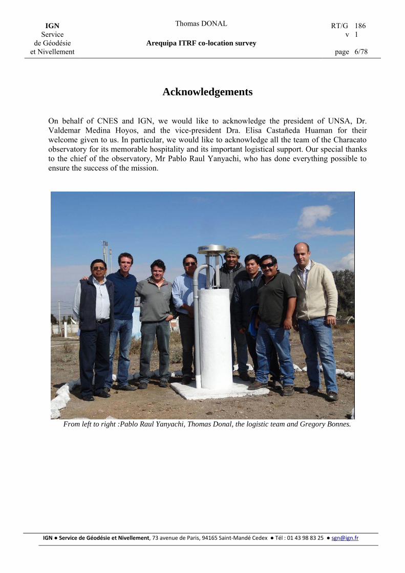
On behalf of CNES and IGN, we would like to acknowledge the president of UNSA, Dr.Valdemar Medina Hoyos, and the vice-president Dra. Elisa Castañeda Huaman for theirwelcome given to us. In particular, we would like to acknowledge all the team of the Characatoobservatory for its memorable hospitality and its important logistical support. Our special thanksto the chief of the observatory, Mr Pablo Raul Yanyachi, who has done everything possible toensure the success of the mission.
From left to right :Pablo Raul Yanyachi, Thomas Donal, the logistic team and Gregory Bonnes.
IGN ● Service de Géodésie et Nivellement, 73 avenue de Paris, 94165 Saint‐Mandé Cedex ● Tél : 01 43 98 83 25 ● [email protected]
IGNService
de Géodésieet Nivellement
Thomas DONAL RT/Gv
page
1861
7/78Arequipa ITRF co-location survey
2. Co‐locationsitedescription
2.1. Site description
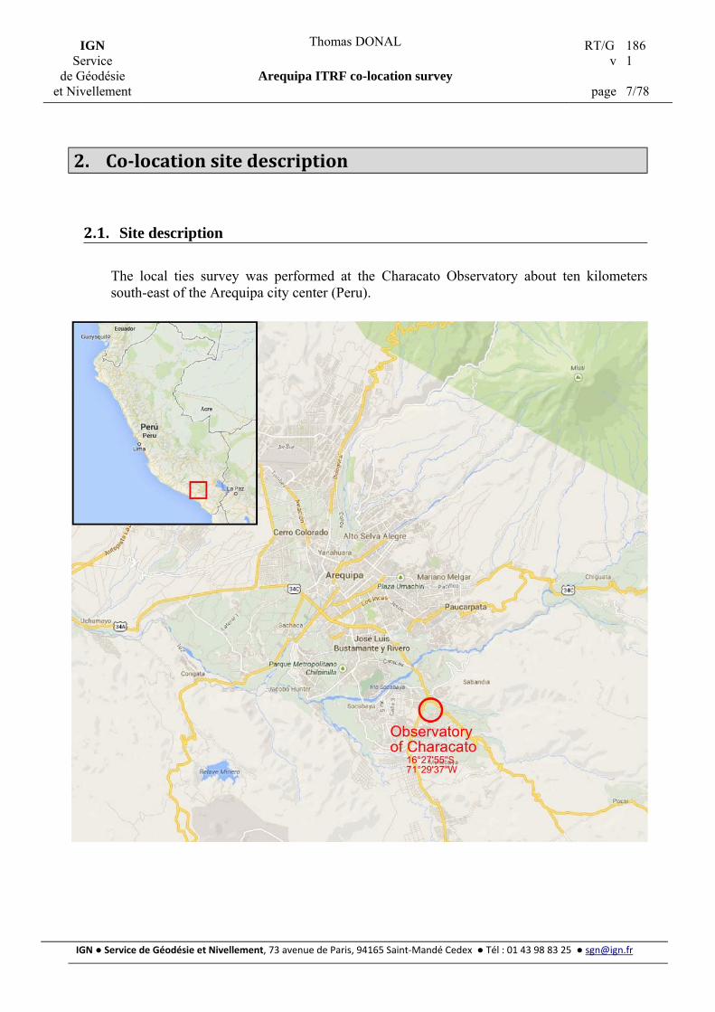
The local ties survey was performed at the Characato Observatory about ten kilometerssouth-east of the Arequipa city center (Peru).
IGN ● Service de Géodésie et Nivellement, 73 avenue de Paris, 94165 Saint‐Mandé Cedex ● Tél : 01 43 98 83 25 ● [email protected]

IGNService
de Géodésieet Nivellement
Thomas DONAL RT/Gv
page
1861
8/78Arequipa ITRF co-location survey
The Characato Observaty depends on the Universidad Nacional de San Agustin (UNSA).
Address
Observatorio de CharacatoTLRS‐3 Nasa Laser Tracking StationsUniversidad Nacional de San AgustinCerro San Franciscos/n CharacatoAREQUIPA – PERUTel : +51‐54‐448211Fax : +51‐54‐448418
IGN ● Service de Géodésie et Nivellement, 73 avenue de Paris, 94165 Saint‐Mandé Cedex ● Tél : 01 43 98 83 25 ● [email protected]

IGNService
de Géodésieet Nivellement
Thomas DONAL RT/Gv
page
1861
9/78Arequipa ITRF co-location survey
From a geodetic point of view, the site is equiped with several scientific instruments :
→ a GPS station→ a GNSS station→ a DORIS station→ a SLR telescope
3D view (azimuth 0°)
In addition to that, few geodetic benchmarks are implanted around these instruments.
IGN ● Service de Géodésie et Nivellement, 73 avenue de Paris, 94165 Saint‐Mandé Cedex ● Tél : 01 43 98 83 25 ● [email protected]
IGNService
de Géodésieet Nivellement
Thomas DONAL RT/Gv
page
1861
10/78Arequipa ITRF co-location survey
2.2. Co‐locatedpoints
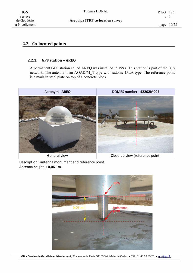
2.2.1. GPSstation–AREQ
A permanent GPS station called AREQ was installed in 1993. This station is part of the IGSnetwork. The antenna is an AOAD/M_T type with radome JPLA type. The reference pointis a mark in steel plate on top of a concrete block.
Acronym : AREQ DOMES number : 42202M005
General view Close‐up view (reference point)
Description : antenna monument and reference point.Antenna height is 0,061 m.
IGN ● Service de Géodésie et Nivellement, 73 avenue de Paris, 94165 Saint‐Mandé Cedex ● Tél : 01 43 98 83 25 ● [email protected]
IGNService
de Géodésieet Nivellement
Thomas DONAL RT/Gv
page
1861
11/78Arequipa ITRF co-location survey
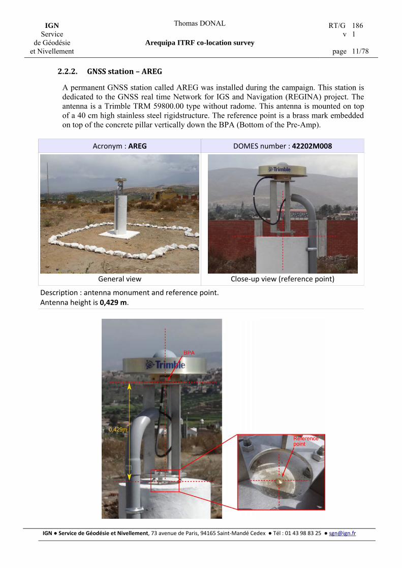
2.2.2. GNSSstation–AREG
A permanent GNSS station called AREG was installed during the campaign. This station isdedicated to the GNSS real time Network for IGS and Navigation (REGINA) project. Theantenna is a Trimble TRM 59800.00 type without radome. This antenna is mounted on topof a 40 cm high stainless steel rigidstructure. The reference point is a brass mark embeddedon top of the concrete pillar vertically down the BPA (Bottom of the Pre-Amp).
Acronym : AREG DOMES number : 42202M008
General view Close‐up view (reference point)
Description : antenna monument and reference point.Antenna height is 0,429 m.
IGN ● Service de Géodésie et Nivellement, 73 avenue de Paris, 94165 Saint‐Mandé Cedex ● Tél : 01 43 98 83 25 ● [email protected]
IGNService
de Géodésieet Nivellement
Thomas DONAL RT/Gv
page
1861
12/78Arequipa ITRF co-location survey
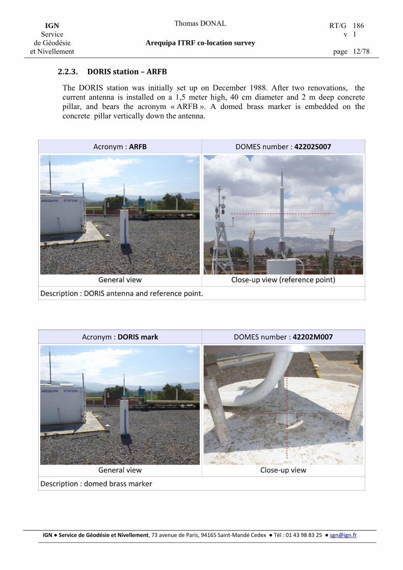
2.2.3. DORISstation–ARFB
The DORIS station was initially set up on December 1988. After two renovations, thecurrent antenna is installed on a 1,5 meter high, 40 cm diameter and 2 m deep concretepillar, and bears the acronym « ARFB ». A domed brass marker is embedded on theconcrete pillar vertically down the antenna.
IGN ● Service de Géodésie et Nivellement, 73 avenue de Paris, 94165 Saint‐Mandé Cedex ● Tél : 01 43 98 83 25 ● [email protected]

IGNService
de Géodésieet Nivellement
Thomas DONAL RT/Gv
page
1861
13/78Arequipa ITRF co-location survey
2.2.4. SLRtelescope–AREL
The Transportable Laser Ranging Station 3 (TLRS-3) has replaced SAO-2 system astracking station since 1992.The SLR measurements refer to a point in the telescope where the two rotation axesintersect. This Ranging System Reference Point (SRP) can’t be materialized.The TLRS-3 SLR system has a removable plate at the top, which is intended to be used as amount for a survey instrument or survey target. The survey mount is approximately 1 mmoffset from the vertical rotation axis. When performing distance measurements to the SLRmount, we observe the measurements with the SLR telescope in one position, then rotate theSLR mount 180 degrees in azimuth and then repeat the measurements, to account for theoffset. The removable plate is 0,174 m above the SRP.
The reference station mark is a standard NASA-GSFC brass disk set flush near the center ofa 1,2 x 1,2 m isolated concrete pad that set in the north end of a 8,2 x 7,6 m concrete pad.The disk is stamped « 7403 89 ». The pad is located inside a 19,8 x 24,4 m fenced area.
The TLRS-3 mount is installed over the 7403 survey mark.
The eccentricities from reference station mark to SRP are :North [m]: 0.0112 +- 0.002East [m]:-0.0046 +- 0.002Up [m]: 2.6951 +- 0.002(see sitelog, appendix 6.4))
To access to the reference mark, the TLRS-3 needs to be put out of order and moved. Thisdecommission was not possible during the surveying operation. So, the reference mark wasunreachable. The survey includes only the survey mount and not the link to the referencemark.
Acronym : AREL DOMES number : 42202M003
General view Reference mark
Description : brass disk under TLRS‐3 mountCDP pad identity: 7403
IGN ● Service de Géodésie et Nivellement, 73 avenue de Paris, 94165 Saint‐Mandé Cedex ● Tél : 01 43 98 83 25 ● [email protected]

IGNService
de Géodésieet Nivellement
Thomas DONAL RT/Gv
page
1861
14/78Arequipa ITRF co-location survey
The vertical offset from SRP to the mount plate is 0,174 m.
IGN ● Service de Géodésie et Nivellement, 73 avenue de Paris, 94165 Saint‐Mandé Cedex ● Tél : 01 43 98 83 25 ● [email protected]
IGNService
de Géodésieet Nivellement
Thomas DONAL RT/Gv
page
1861
15/78Arequipa ITRF co-location survey
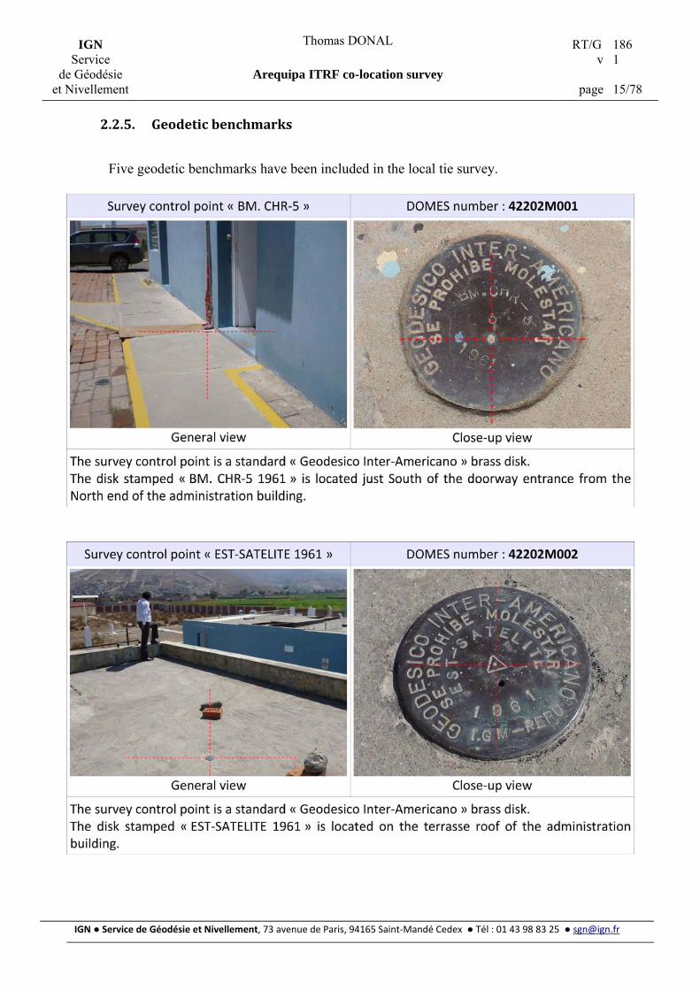
2.2.5. Geodeticbenchmarks
Five geodetic benchmarks have been included in the local tie survey.
IGN ● Service de Géodésie et Nivellement, 73 avenue de Paris, 94165 Saint‐Mandé Cedex ● Tél : 01 43 98 83 25 ● [email protected]

IGNService
de Géodésieet Nivellement
Thomas DONAL RT/Gv
page
1861
16/78Arequipa ITRF co-location survey
IGN ● Service de Géodésie et Nivellement, 73 avenue de Paris, 94165 Saint‐Mandé Cedex ● Tél : 01 43 98 83 25 ● [email protected]
IGNService
de Géodésieet Nivellement
Thomas DONAL RT/Gv
page
1861
17/78Arequipa ITRF co-location survey
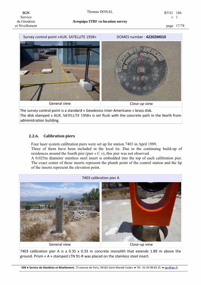
2.2.6. Calibrationpiers
Four laser system calibration piers were set up for station 7403 in April 1989.Three of them have been included in the local tie. Due to the continuing build-up ofresidences around the fourth pier (pier « C »), this pier was not observed.A 0.025m diameter stainless steel insert is embedded into the top of each calibration pier.The exact center of these inserts represent the plumb point of the control station and the lipof the inserts represent the elevation point.
7403 calibration pier A
General view Close‐up view
7403 calibration pier A is a 0.35 x 0.33 m concrete monolith that extends 1.89 m above theground. Prism « A » stamped LTN 91‐R was placed on the stainless steel insert.
IGN ● Service de Géodésie et Nivellement, 73 avenue de Paris, 94165 Saint‐Mandé Cedex ● Tél : 01 43 98 83 25 ● [email protected]

IGNService
de Géodésieet Nivellement
Thomas DONAL RT/Gv
page
1861
18/78Arequipa ITRF co-location survey
7403 calibration pier B
General view Close‐up view
7403 calibration pier B is a 0.34 x 0.34 m concrete monolith that extends 2,23 m above theground. A permanent prism « B » stamped 86‐5 is placed on the stainless steel insert.
7403 calibration pier D
General view Close‐up view
7403 calibration pier D is a 0.33 x 0.33 m concrete monolith that extends 1,85 m above theground. Prism « D» stamped 86‐1 was placed on the stainless steel insert.
Adjusted coordinates from calibration piers published in this document correspond to theprisms center.
IGN ● Service de Géodésie et Nivellement, 73 avenue de Paris, 94165 Saint‐Mandé Cedex ● Tél : 01 43 98 83 25 ● [email protected]
IGNService
de Géodésieet Nivellement
Thomas DONAL RT/Gv
page
1861
19/78Arequipa ITRF co-location survey
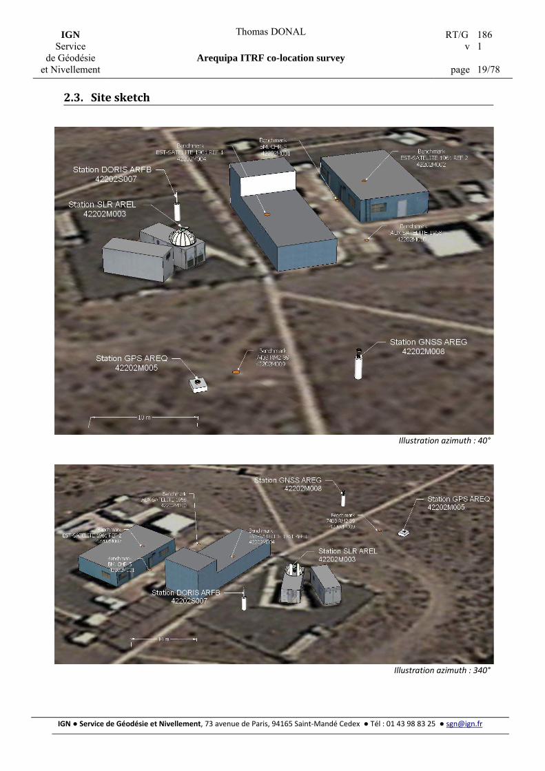
2.3. Sitesketch
Illustration azimuth : 40°
Illustration azimuth : 340°
IGN ● Service de Géodésie et Nivellement, 73 avenue de Paris, 94165 Saint‐Mandé Cedex ● Tél : 01 43 98 83 25 ● [email protected]
IGNService
de Géodésieet Nivellement
Thomas DONAL RT/Gv
page
1861
20/78Arequipa ITRF co-location survey
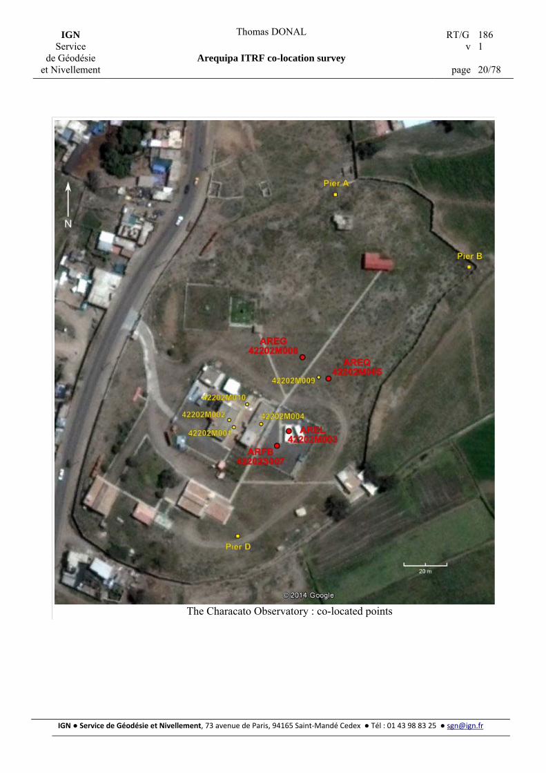
The Characato Observatory : co-located points
IGN ● Service de Géodésie et Nivellement, 73 avenue de Paris, 94165 Saint‐Mandé Cedex ● Tél : 01 43 98 83 25 ● [email protected]
IGNService
de Géodésieet Nivellement
Thomas DONAL RT/Gv
page
1861
21/78Arequipa ITRF co-location survey
3. Surveydescription
3.1. Organization
The local ties survey was conducted during the AREG GNSS station installation, part of theREGINA network, on which the two following french agencies participated :- Centre National d'Etudes Spatiales – CNES, France ;- Institut National de l'Information Géographique et Forestière – IGN, France ;
The survey took place from January 11th to January 14th, 2013 and was operated byThomas Donal (IGN) and Gregory Bonnes (mandated by CNES).
3.2. Equipment
All the survey instruments used for this project belong to IGN.
3.2.1. GNSSREGINApermanentstation
Type Model Quantity
GNSS antenna Trimble chokering TRM 59800.00 1
GNSS receiver Trimble NetR9 1
3.2.2. Surveyinstruments
The Leica total station used for the survey, is yearly calibrated at IGN's calibration unit. Ithas a standard deviation of 0.3 mgon for angles and 1mm + 1.5 ppm for distances.
Type Model Quantity
GNSS receiver Leica GX1230GG 2
GNSS antenna Leica AX1202GG 2
Total station Leica TCRA 1201+ 1
IGN ● Service de Géodésie et Nivellement, 73 avenue de Paris, 94165 Saint‐Mandé Cedex ● Tél : 01 43 98 83 25 ● [email protected]
IGNService
de Géodésieet Nivellement
Thomas DONAL RT/Gv
page
1861
22/78Arequipa ITRF co-location survey
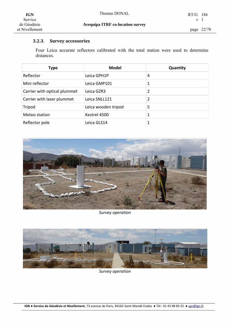
3.2.3. Surveyaccessories
Four Leica accurate reflectors calibrated with the total station were used to determinedistances.
Type Model Quantity
Reflector Leica GPH1P 4
Mini reflector Leica GMP101 1
Carrier with optical plummet Leica GZR3 2
Carrier with laser plummet Leica SNLL121 2
Tripod Leica wooden tripod 5
Meteo station Kestrel 4500 1
Reflector pole Leica GLS14 1
Survey operation
Survey operation
IGN ● Service de Géodésie et Nivellement, 73 avenue de Paris, 94165 Saint‐Mandé Cedex ● Tél : 01 43 98 83 25 ● [email protected]
IGNService
de Géodésieet Nivellement
Thomas DONAL RT/Gv
page
1861
23/78Arequipa ITRF co-location survey
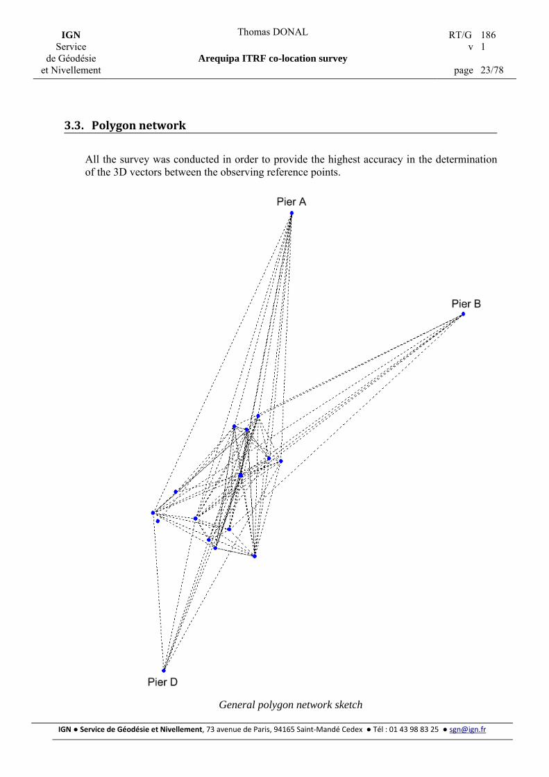
3.3. Polygonnetwork
All the survey was conducted in order to provide the highest accuracy in the determinationof the 3D vectors between the observing reference points.
General polygon network sketch
IGN ● Service de Géodésie et Nivellement, 73 avenue de Paris, 94165 Saint‐Mandé Cedex ● Tél : 01 43 98 83 25 ● [email protected]
IGNService
de Géodésieet Nivellement
Thomas DONAL RT/Gv
page
1861
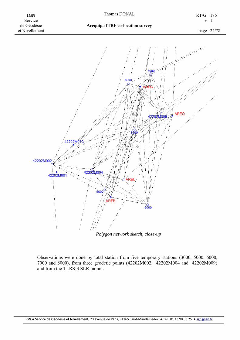
24/78Arequipa ITRF co-location survey
Polygon network sketch, close-up
Observations were done by total station from five temporary stations (3000, 5000, 6000,7000 and 8000), from three geodetic points (42202M002, 42202M004 and 42202M009)and from the TLRS-3 SLR mount.
IGN ● Service de Géodésie et Nivellement, 73 avenue de Paris, 94165 Saint‐Mandé Cedex ● Tél : 01 43 98 83 25 ● [email protected]
IGNService
de Géodésieet Nivellement
Thomas DONAL RT/Gv
page
1861
25/78Arequipa ITRF co-location survey
3.4. Surveymethod
All the visible lines of sight have been observed with the total station . Horizontal directionsand zenith angles were observed in data sets, each set consisting in one reading in bothdirect and reverse theodolite positions. Distance measurements were observed at least twiceover each line. Meteorological data (atmospheric pressure and temperature) used to correctthe distances, were recorded during the operation.The set up strategy mixes GNSS and conventional observations. The GNSS observations areused to get the polygon bearing.
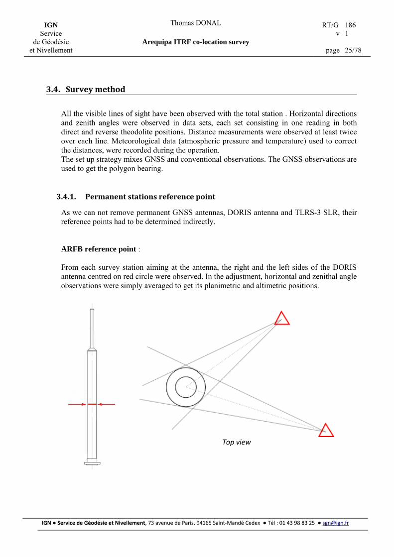
3.4.1. Permanentstationsreferencepoint
As we can not remove permanent GNSS antennas, DORIS antenna and TLRS-3 SLR, theirreference points had to be determined indirectly.
ARFB reference point :
From each survey station aiming at the antenna, the right and the left sides of the DORISantenna centred on red circle were observed. In the adjustment, horizontal and zenithal angleobservations were simply averaged to get its planimetric and altimetric positions.
Top view
IGN ● Service de Géodésie et Nivellement, 73 avenue de Paris, 94165 Saint‐Mandé Cedex ● Tél : 01 43 98 83 25 ● [email protected]
IGNService
de Géodésieet Nivellement
Thomas DONAL RT/Gv
page
1861
26/78Arequipa ITRF co-location survey
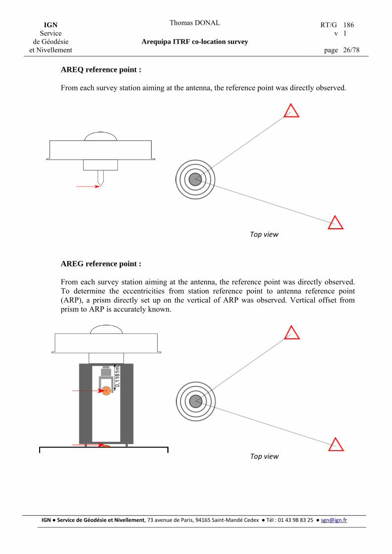
AREQ reference point :
From each survey station aiming at the antenna, the reference point was directly observed.
Top view
AREG reference point :
From each survey station aiming at the antenna, the reference point was directly observed.To determine the eccentricities from station reference point to antenna reference point(ARP), a prism directly set up on the vertical of ARP was observed. Vertical offset fromprism to ARP is accurately known.
Top view
IGN ● Service de Géodésie et Nivellement, 73 avenue de Paris, 94165 Saint‐Mandé Cedex ● Tél : 01 43 98 83 25 ● [email protected]

IGNService
de Géodésieet Nivellement
Thomas DONAL RT/Gv
page
1861
27/78Arequipa ITRF co-location survey
AREL reference point :
From each survey station aiming at the SLR, the prism installed on the survey mount wasobserved in one position, then rotate the SLR mount 180 degrees in azimuth and then repeatthe measurements. In the adjustment, horizontal and zenithal angle observations were simplyaveraged to get its planimetric and altimetric positions.The vertical offset from SRP (rotation axis) to prism, as well as the eccentricities fromreference station mark to SRP are accurately known from previous measurements.
3.4.2. GNSSobservations
GNSS observations are carried out in order to determine the orientation of the surveynetwork. Orientations are ensured by the baselines from AREQ to Pier A and D. Due to thepermanent prism installed on Pier B, GNSS onservations are not possible on this point.
IGN ● Service de Géodésie et Nivellement, 73 avenue de Paris, 94165 Saint‐Mandé Cedex ● Tél : 01 43 98 83 25 ● [email protected]

IGNService
de Géodésieet Nivellement
Thomas DONAL RT/Gv
page
1861
28/78Arequipa ITRF co-location survey
4. Computation
4.1. GNSSnetwork
Back to the office, the GNSS baselines were processed with Leica Geo Office V8.1 softwareusing IGS08 precise ephemeris and the original set of « absolute » GNSS antennacalibrations (igs08.atx). AREQ coordinates come from the station in IGS08 at epoch2013:03 of the corresponding IGS RF weekly solution (i.e. file igs13P1722.ssc)
The corresponding LGO report file is given in appendix 6.5.
4.2. Globaladjustment
The final computation has been carried out by a Least Squares 3D Adjustment with theMicrosearch Geolab version 2001.9.20.0 software. The input file (see appendix 6.6) comesfrom :→ Total station observations : horizontal and zenith angles, distances,→ Centring equations : relative position between points,→ Azimuths issued from the GNSS baselines process,→ AREQ coordinates have been constrained at 1 mm to its IGS08 (epoch 2013:03) values.The a priori standard deviations used for the different observations with total station are :→ 0.8 mgon for horizontal and vertical angles,→ 1 mm for distances on prism,These are the values used for most of the targets in our Microsearch Geolab computationinput file.This adjustment provided coordinates and a covariance matrix of our survey work (appendix6.7).
Arequipa is bordered by mountains. Geoid slope is significant. The undulation of the geoidmodel EGM08 has been taken into account in the process.
IGN ● Service de Géodésie et Nivellement, 73 avenue de Paris, 94165 Saint‐Mandé Cedex ● Tél : 01 43 98 83 25 ● [email protected]
IGNService
de Géodésieet Nivellement
Thomas DONAL RT/Gv
page
1861
29/78Arequipa ITRF co-location survey
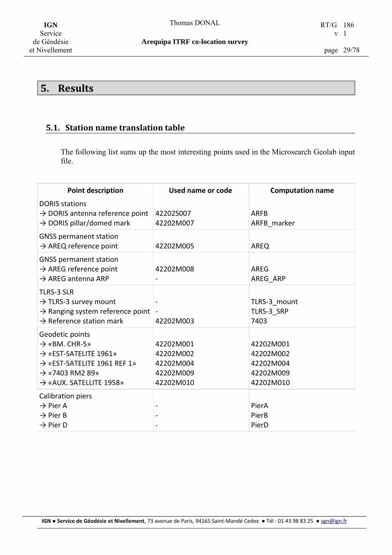
5. Results
5.1. Stationnametranslationtable
The following list sums up the most interesting points used in the Microsearch Geolab inputfile.
Point description Used name or code Computation name
DORIS stations→ DORIS antenna reference point→ DORIS pillar/domed mark
42202S00742202M007
ARFBARFB_marker
GNSS permanent station→ AREQ reference point 42202M005 AREQ
GNSS permanent station→ AREG reference point→ AREG antenna ARP
42202M008‐
AREGAREG_ARP
TLRS‐3 SLR→ TLRS‐3 survey mount→ Ranging system reference point→ Reference station mark
‐‐42202M003
TLRS‐3_mountTLRS‐3_SRP7403
Geodetic points→ «BM. CHR‐5»→ «EST‐SATELITE 1961»→ «EST‐SATELITE 1961 REF 1»→ «7403 RM2 89»→ «AUX. SATELLITE 1958»
42202M00142202M00242202M00442202M00942202M010
42202M00142202M00242202M00442202M00942202M010
Calibration piers→ Pier A→ Pier B→ Pier D
‐‐‐
PierAPierBPierD
IGN ● Service de Géodésie et Nivellement, 73 avenue de Paris, 94165 Saint‐Mandé Cedex ● Tél : 01 43 98 83 25 ● [email protected]

IGNService
de Géodésieet Nivellement
Thomas DONAL RT/Gv
page
1861
30/78Arequipa ITRF co-location survey
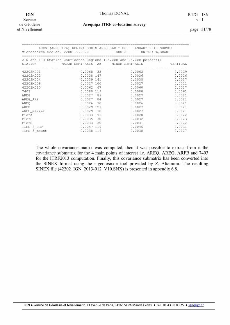
5.2. Adjustedcoordinatesandconfidenceregions
The results of the adjustment are the coordinates of all points and their confidence ellipsoidsin the ITRF2008 at the mean epoch of the observations (i.e. epoch 2013 :03).The table below provides the 3D coordinates and confidence region at 95 % of the points ofinterest.
================================================================================ AREG (AREQUIPA) REGINA-DORIS-AREQ-SLR TIES - JANUARY 2013 SURVEYMicrosearch GeoLab, V2001.9.20.0 GRS 80 UNITS: m,GRAD ================================================================================Adjusted XYZ Coordinates: X-COORDINATE Y-COORDINATE Z-COORDINATE CODE FFF STATION STD DEV STD DEV STD DEV ---- --- ------------ ------------------ ------------------ ------------------ XYZ 42202M001 1942785.0322 -5804077.8842 -1796913.0713 m 0 0.0025 0.0017 0.0026 XYZ 42202M002 1942784.5359 -5804081.6974 -1796911.2333 m 0 0.0015 0.0014 0.0015 XYZ 42202M004 1942797.9661 -5804076.7189 -1796913.0034 m 0 0.0016 0.0018 0.0016 XYZ 42202M009 1942822.3955 -5804071.4272 -1796893.2395 m 0 0.0011 0.0011 0.0011 XYZ 42202M010 1942791.6315 -5804078.6736 -1796903.8810 m 0 0.0024 0.0016 0.0024 XYZ 7403 1942807.6082 -5804069.7829 -1796915.6836 m 0 0.0032 0.0031 0.0032 XYZ AREG 1942816.3642 -5804077.1455 -1796884.4274 m 0 0.0011 0.0011 0.0011 XYZ AREG_ARP 1942816.4942 -5804077.5359 -1796884.5491 m 0 0.0011 0.0011 0.0011 XYZ AREQ 1942826.2250 -5804070.3420 -1796894.1910 m 0 0.0011 0.0011 0.0011 XYZ ARFB 1942803.3526 -5804071.5748 -1796922.1421 m 0 0.0011 0.0011 0.0011 XYZ ARFB_marker 1942803.1586 -5804070.9977 -1796921.9615 m 0 0.0011 0.0011 0.0011 XYZ PierA 1942836.6959 -5804090.1053 -1796815.9438 m 0 0.0013 0.0012 0.0011 XYZ PierB 1942888.9051 -5804064.0584 -1796848.0381 m 0 0.0014 0.0012 0.0014 XYZ PierD 1942782.5293 -5804064.3253 -1796960.1331 m 0 0.0013 0.0012 0.0013 XYZ TLRS-3_SRP 1942808.4252 -5804072.2382 -1796916.4368 m 0 0.0019 0.0017 0.0019 XYZ TLRS-3_mount 1942808.4782 -5804072.3965 -1796916.4862 m 0 0.0015 0.0014 0.0015
IGN ● Service de Géodésie et Nivellement, 73 avenue de Paris, 94165 Saint‐Mandé Cedex ● Tél : 01 43 98 83 25 ● [email protected]
IGNService
de Géodésieet Nivellement
Thomas DONAL RT/Gv
page
1861
31/78Arequipa ITRF co-location survey
================================================================================ AREG (AREQUIPA) REGINA-DORIS-AREQ-SLR TIES - JANUARY 2013 SURVEYMicrosearch GeoLab, V2001.9.20.0 GRS 80 UNITS: m,GRAD ================================================================================2-D and 1-D Station Confidence Regions (95.000 and 95.000 percent):STATION MAJOR SEMI-AXIS AZ MINOR SEMI-AXIS VERTICAL------------ --------------------- --- ------------------- --------------------42202M001 0.0065 33 0.0063 0.002942202M002 0.0038 147 0.0036 0.002642202M004 0.0039 141 0.0038 0.003742202M009 0.0027 100 0.0027 0.002142202M010 0.0062 67 0.0060 0.00277403 0.0080 119 0.0080 0.0061AREG 0.0027 89 0.0027 0.0021AREG_ARP 0.0027 84 0.0027 0.0021AREQ 0.0026 90 0.0026 0.0021ARFB 0.0029 129 0.0027 0.0021ARFB_marker 0.0029 130 0.0027 0.0021PierA 0.0033 93 0.0028 0.0022PierB 0.0035 130 0.0032 0.0023PierD 0.0033 130 0.0031 0.0022TLRS-3_SRP 0.0047 119 0.0046 0.0031TLRS-3_mount 0.0038 119 0.0038 0.0027
The whole covariance matrix was computed, then it was possible to extract from it thecovariance submatrix for the 4 main points of interest i.e. AREQ, AREG, ARFB and 7403for the ITRF2013 computation. Finally, this covariance submatrix has been converted intothe SINEX format using the « geotosnx » tool provided by Z. Altamimi. The resultingSINEX file (42202_IGN_2013-012_V10.SNX) is presented in appendix 6.8.
IGN ● Service de Géodésie et Nivellement, 73 avenue de Paris, 94165 Saint‐Mandé Cedex ● Tél : 01 43 98 83 25 ● [email protected]

IGNService
de Géodésieet Nivellement
Thomas DONAL RT/Gv
page
1861
32/78Arequipa ITRF co-location survey
6. Appendixes
6.1. «ARFB»DORISstationsitelog
AREQUIPA DORIS site description form
0. Form
Prepared by : SIMB (DORIS installation and maintenance department) Date prepared : 30/01/2013 Report type : UPDATE
1. Site location information
Site name : AREQUIPA Site DOMES number : 42202 Host agency : UNIVERSIDAD NACIONAL DE SAN AGUSTIN City : Arequipa State or province : Country : PERU Tectonic plate : SOAM Geological information :
Geographical coordinates (ITRF) : North Latitude : -16 deg 27' 57'' East Longitude : -71 deg 29' 35'' Ellipsoid height : 2490 m Approximate altitude : 2446 m
2. DORIS antenna and reference point information
2.1 Four character ID : AREA Antenna model : Alcatel Antenna serial number : 44 IERS DOMES number : 42202S005 CNES/IGN number : 422021 DORIS SSALTO number : 46 Date installed (dd/mm/yy): 16/12/1988 Date removed (dd/mm/yy) : 20/11/2001 Antenna support type : Guyed 2 metre tower Installed on : Top of a load-bearing wall of a one storied building with terrace roof. Height above ground mark : 2.198 m Ground mark type : Brass mark 12 mm diam. Ground mark DOMES number : 42202M006 Notes :
2.2 Four character ID : AREB Antenna model : Starec 52291 type Antenna serial number : 82 IERS DOMES number : 42202S006 CNES/IGN number : 422022 DORIS SSALTO number : 221 Date installed (dd/mm/yy): 21/11/2001 Date removed (dd/mm/yy) : 01/08/2006 Antenna support type : 40 cm diameter, 1.5 m high and 2m deep concrete pillar Installed on : 2 m sided, 0.5 m thick concrete footing at 2 m depth Height above ground mark : 0.487 m
IGN ● Service de Géodésie et Nivellement, 73 avenue de Paris, 94165 Saint‐Mandé Cedex ● Tél : 01 43 98 83 25 ● [email protected]

IGNService
de Géodésieet Nivellement
Thomas DONAL RT/Gv
page
1861
33/78Arequipa ITRF co-location survey
Ground mark type : Domed brass mark 12 mm diameter on pillar Ground mark DOMES number : 42202M007 Notes :
2.3 Four character ID : ARFB Antenna model : Starec 52291 type Antenna serial number : 82 IERS DOMES number : 42202S007 CNES/IGN number : 422023 DORIS SSALTO number : 274 Date installed (dd/mm/yy): 02/08/2006 Date removed (dd/mm/yy) : Antenna support type : 40 cm diameter, 1.5 m high and 2m deep concrete pillar Installed on : 2 m sided, 0.5 m thick concrete footing at 2 m depth Height above ground mark : 0.637 m Ground mark type : Domed brass mark 12 mm diameter on pillar Ground mark DOMES number : 42202M007 Notes :
3. DORIS beacons information
3.1 Beacon serial number : 8633046 Beacon model : 1.0 USO serial number : 1.400 4 Char. ID of the REF point : AREA Date installed (dd/mm/yy) : 16/12/1988 Date removed (dd/mm/yy) : 01/12/1992
3.2 Beacon serial number : 8627016 Beacon model : 1.0 USO serial number : 1.403 4 Char. ID of the REF point : AREA Date installed (dd/mm/yy) : 02/03/1993 Date removed (dd/mm/yy) : 20/11/2001
3.3 Beacon serial number : 8627016 Beacon model : 1.0 USO serial number : 1.403 4 Char. ID of the REF point : AREB Date installed (dd/mm/yy) : 21/11/2001 Date removed (dd/mm/yy) : 31/07/2006
3.4 Beacon serial number : 2819010 Beacon model : 3.0 USO serial number : 3.226 4 Char. ID of the REF point : ARFB Date installed (dd/mm/yy) : 01/08/2006 Date removed (dd/mm/yy) : 14/09/2011
3.5 Beacon serial number : 2819035 Beacon model : 3.0 USO serial number : 3.223 4 Char. ID of the REF point : ARFB Date installed (dd/mm/yy) : 14/09/2011 Date removed (dd/mm/yy) :
4. ITRF coordinates and velocities of the current DORIS ref. point (ARFB)
Solution : DPOD2008 Epoch : 2005.0
X = 1942803.313 m Y = -5804071.540 m Z = -1796922.189 m Sig X = 0.003 m Sig Y = 0.001 m Sig Z = 0.001 m
VX = -0.0011 m/y VY = -0.0059 m/y VZ = 0.0106 m/y
IGN ● Service de Géodésie et Nivellement, 73 avenue de Paris, 94165 Saint‐Mandé Cedex ● Tél : 01 43 98 83 25 ● [email protected]

IGNService
de Géodésieet Nivellement
Thomas DONAL RT/Gv
page
1861
34/78Arequipa ITRF co-location survey
Sig VX = m/y Sig VY = m/y Sig VZ = m/y
5. IERS colocation information
5.1 Instrument type : GNSS Status : Permanent DOMES number of the instrument ref. point : 42202M005 Notes :
5.2 Instrument type : SLR Status : Permanent DOMES number of the instrument ref. point : 42202S001 Notes :
6. Tide Gauge colocation information
7. Local site ties
7.1 Point description : DORIS Alcatel antenna reference point (AREA) DOMES number : 42202S005 Differential components from the current DORIS ref. point (ARFB) to the above point (in the ITRS) : dX (m) : -7.107 dY (m) : -6.233 dZ (m) : 2.814 Accuracy (m) : 0.002 Date measured : 01/11/2001 Additional information : Survey by IGN-F
7.2 Point description : GPS Mark 4021-S (IGS station AREQ) DOMES number : 42202M005 Differential components from the current DORIS ref. point (ARFB) to the above point (in the ITRS) : dX (m) : 22.873 dY (m) : 1.232 dZ (m) : 27.950 Accuracy (m) : 0.001 Date measured : 01/11/2001 Additional information : Survey by IGN-F
7.3 Point description : DORIS Starec antenna reference point (AREB) DOMES number : 42202S006 Differential components from the current DORIS ref. point (ARFB) to the above point (in the ITRS) : dX (m) : -0.046 dY (m) : 0.136 dZ (m) : 0.043 Accuracy (m) : 0.001 Date measured : 01/08/2006 Additional information : Survey by IGN-F
7.4 Point description : Mark on concrete pillar, under the DORIS antenna DOMES number : 42202M007 Differential components from the current DORIS ref. point (ARFB) to the above point (in the ITRS) : dX (m) : -0.194 dY (m) : 0.579 dZ (m) : 0.181 Accuracy (m) : 0.001 Date measured : 01/08/2006 Additional information : Survey by IGN-F
8. Meteorological Instrumentation
IGN ● Service de Géodésie et Nivellement, 73 avenue de Paris, 94165 Saint‐Mandé Cedex ● Tél : 01 43 98 83 25 ● [email protected]
IGNService
de Géodésieet Nivellement
Thomas DONAL RT/Gv
page
1861
35/78Arequipa ITRF co-location survey
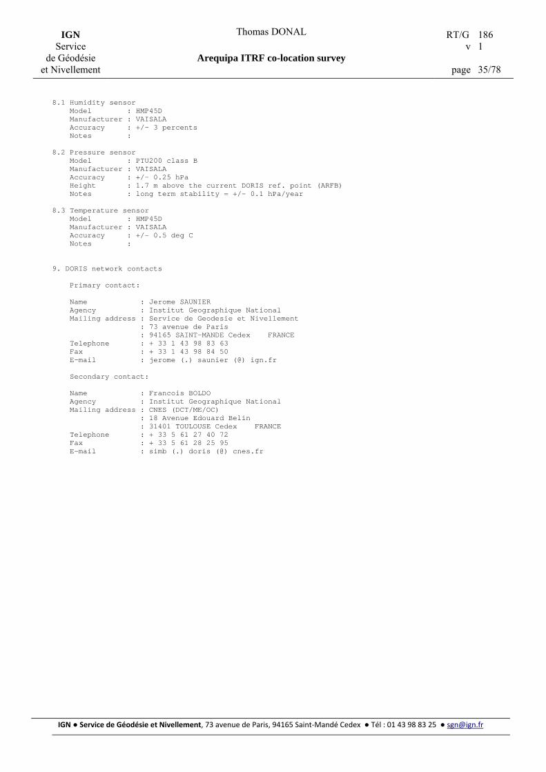
8.1 Humidity sensor Model : HMP45D Manufacturer : VAISALA Accuracy : +/- 3 percents Notes :
8.2 Pressure sensor Model : PTU200 class B Manufacturer : VAISALA Accuracy : +/- 0.25 hPa Height : 1.7 m above the current DORIS ref. point (ARFB) Notes : long term stability = +/- 0.1 hPa/year
8.3 Temperature sensor Model : HMP45D Manufacturer : VAISALA Accuracy : +/- 0.5 deg C Notes :
9. DORIS network contacts
Primary contact:
Name : Jerome SAUNIER Agency : Institut Geographique National Mailing address : Service de Geodesie et Nivellement : 73 avenue de Paris : 94165 SAINT-MANDE Cedex FRANCE Telephone : + 33 1 43 98 83 63 Fax : + 33 1 43 98 84 50 E-mail : jerome (.) saunier (@) ign.fr
Secondary contact:
Name : Francois BOLDO Agency : Institut Geographique National Mailing address : CNES (DCT/ME/OC) : 18 Avenue Edouard Belin : 31401 TOULOUSE Cedex FRANCE Telephone : + 33 5 61 27 40 72 Fax : + 33 5 61 28 25 95 E-mail : simb (.) doris (@) cnes.fr
IGN ● Service de Géodésie et Nivellement, 73 avenue de Paris, 94165 Saint‐Mandé Cedex ● Tél : 01 43 98 83 25 ● [email protected]

IGNService
de Géodésieet Nivellement
Thomas DONAL RT/Gv
page
1861
36/78Arequipa ITRF co-location survey
6.2. «AREQ»GNSSstationsitelog(extract)
Note : only the most relevant points to this survey were retained in the following extract.The complete version of this site log is available at :http://www.igs.org/network/network_by_site.php?site=areq
AREQSiteInformationForm(sitelog) International GNSS Service See Instructions at: ftp://igscb.jpl.nasa.gov/pub/station/general/sitelog_instr.txt
0. Form
Prepared by (full name) : David Maggert Date Prepared : 2013-01-31 Report Type : UPDATE If Update: Previous Site Log : areq_20120217.log Modified/Added Sections : 10.5
1. Site Identification of the GNSS Monument
Site Name : Arequipa Laser Station Four Character ID : AREQ Monument Inscription : 4021-S IERS DOMES Number : 42202M005 CDP Number : None Monument Description : CONCRETE PILLAR Height of the Monument : 0.7 Monument Foundation : CONCRETE BLOCK Foundation Depth : Marker Description : DIVOT IN STEEL PLATE Date Installed : 1993-01-01 Geologic Characteristic : Bedrock Type : Bedrock Condition : Fracture Spacing : Fault zones nearby : Distance/activity : Additional Information : Eugeosynclinal belt of Mesozoic Age : Quaternary alluvium overlying granodioritic : upper Cretaceous lower Tertiary coastal : batholith. This batholith contains faulted : inliers of Precambrian gneiss. : The monument is ~50 m north of : TLRS-3 Laser station : Geological information from "NASA Space Geodesy : Program Memorandum 4482" p10.
2. Site Location Information
City or Town : Arequipa State or Province : Country : Peru Tectonic Plate : SOUTH AMERICAN Approximate Position (ITRF) X coordinate (m) : 1942826.1920 Y coordinate (m) : -5804070.3310 Z coordinate (m) : -1796894.2670 Latitude (N is +) : -162755.8612 Longitude (E is +) : -0712934.0680 Elevation (m,ellips.) : 2488.9226 Additional Information : The site is located in western South America in : southern Peru at the Smithsonian Astronomical : Observatory.
IGN ● Service de Géodésie et Nivellement, 73 avenue de Paris, 94165 Saint‐Mandé Cedex ● Tél : 01 43 98 83 25 ● [email protected]

IGNService
de Géodésieet Nivellement
Thomas DONAL RT/Gv
page
1861
37/78Arequipa ITRF co-location survey
3. GNSS Receiver Information
3.1 Receiver Type : ROGUE SNR-8000 (...)
3.2 Receiver Type : ROGUE SNR-8000 (...)
3.3 Receiver Type : ROGUE SNR-8000 (...)
3.4 Receiver Type : ROGUE SNR-8000 (...)
3.5 Receiver Type : AOA SNR-8000 ACT (...)
3.6 Receiver Type : ASHTECH UZ-12 (...)
3.7 Receiver Type : ASHTECH UZ-12 Satellite System : GPS Serial Number : ZR220010401 Firmware Version : CQ00 Elevation Cutoff Setting : 4 Date Installed : 2006-05-21T00:00Z Date Removed : CCYY-MM-DDThh:mmZ Temperature Stabiliz. : none Additional Information :
3.x Receiver Type : (A20, from rcvr_ant.tab; see instructions) Satellite System : (GPS+GLO+GAL+BDS+QZSS+SBAS) Serial Number : (A20, but note the first A5 is used in SINEX) Firmware Version : (A11) Elevation Cutoff Setting : (deg) Date Installed : (CCYY-MM-DDThh:mmZ) Date Removed : (CCYY-MM-DDThh:mmZ) Temperature Stabiliz. : (none or tolerance in degrees C) Additional Information : (multiple lines)
4. GNSS Antenna Information
4.1 Antenna Type : AOAD/M_T JPLA (...)
4.2 Antenna Type : AOAD/M_T JPLA (...)
4.3 Antenna Type : AOAD/M_T JPLA (...)
4.4 Antenna Type : AOAD/M_T NONE (...)
4.5 Antenna Type : AOAD/M_T JPLA Serial Number : 294 Antenna Reference Point : BPA Marker->ARP Up Ecc. (m) : 0.061 Marker->ARP North Ecc(m) : 0.000 Marker->ARP East Ecc(m) : 0.000 Alignment from True N : Antenna Radome Type : JPLA Radome Serial Number : Antenna Cable Type : Hutton LMR400 Antenna Cable Length : 45 m Date Installed : 2012-02-03T00:00Z Date Removed : CCYY-MM-DDThh:mmZ Additional Information : JPLA radome re-installed
4.x Antenna Type : (A20, from rcvr_ant.tab; see instructions) Serial Number : (A*, but note the first A5 is used in SINEX) Antenna Reference Point : (BPA/BCR/XXX from "antenna.gra"; see instr.) Marker->ARP Up Ecc. (m) : (F8.4) Marker->ARP North Ecc(m) : (F8.4)
IGN ● Service de Géodésie et Nivellement, 73 avenue de Paris, 94165 Saint‐Mandé Cedex ● Tél : 01 43 98 83 25 ● [email protected]
IGNService
de Géodésieet Nivellement
Thomas DONAL RT/Gv
page
1861
38/78Arequipa ITRF co-location survey
Marker->ARP East Ecc(m) : (F8.4) Alignment from True N : (deg; + is clockwise/east) Antenna Radome Type : (A4 from rcvr_ant.tab; see instructions) Radome Serial Number : Antenna Cable Type : (vendor & type number) Antenna Cable Length : (m) Date Installed : (CCYY-MM-DDThh:mmZ) Date Removed : (CCYY-MM-DDThh:mmZ) Additional Information : (multiple lines)
5. Surveyed Local Ties
5.1 Tied Marker Name : CDP Station-7403 Tied Marker Usage : SLR Tied Marker CDP Number : 7403 Tied Marker DOMES Number : 42202M003 Differential Components from GNSS Marker to the tied monument (ITRS) dx (m) : -18.6152 dy (m) : 0.5478 dz (m) : -21.4987 Accuracy (mm) : Survey method : Date Measured : 1994-03-07 Additional Information : Mark SLR : Site Ref Domes Number and information from : "IERS Tech Note 20, Results and Analysis of the : ITRF94" March 1996, Tables T2 pT24 and T4 pT56.
5.2 Tied Marker Name : EST SATELITE (East Satellite mark Ref. 1) Tied Marker Usage : Tied Marker CDP Number : none Tied Marker DOMES Number : 42202M004 Differential Components from GNSS Marker to the tied monument (ITRS) dx (m) : -41.6902 dy (m) : -11.3518 dz (m) : -17.0411 Accuracy (mm) : Survey method : Date Measured : 1994-03-07 Additional Information : No CDP number listed in, and Monument Name in : parentheses from : and Analysis of the ITRF94" March 1996, Table T2 : pT24.
5.3 Tied Marker Name : DORIS Ref Pt Tied Marker Usage : Tied Marker CDP Number : none Tied Marker DOMES Number : 42202S005 Differential Components from GNSS Marker to the tied monument (ITRS) dx (m) : -29.9827 dy (m) : -07.4719 dz (m) : -25.1257 Accuracy (mm) : Survey method : Date Measured : 1994-03-07 Additional Information : No CDP number listed in Table T2 pT24, and Site : Ref Domes from Tables T2 pT24 and T4 pT56 : Tech Note 20, Results and Analysis of the : ITRF94" March 1996.
5.x Tied Marker Name : Tied Marker Usage : (SLR/VLBI/LOCAL CONTROL/FOOTPRINT/etc) Tied Marker CDP Number : (A4) Tied Marker DOMES Number : (A9) Differential Components from GNSS Marker to the tied monument (ITRS) dx (m) : (m) dy (m) : (m) dz (m) : (m) Accuracy (mm) : (mm) Survey method : (GPS CAMPAIGN/TRILATERATION/TRIANGULATION/etc) Date Measured : (CCYY-MM-DDThh:mmZ) Additional Information : (multiple lines)
IGN ● Service de Géodésie et Nivellement, 73 avenue de Paris, 94165 Saint‐Mandé Cedex ● Tél : 01 43 98 83 25 ● [email protected]
IGNService
de Géodésieet Nivellement
Thomas DONAL RT/Gv
page
1861
39/78Arequipa ITRF co-location survey
6. Frequency Standard
(...)
7. Collocation Information
7.1 Instrumentation Type : DORIS/SLR Status : (PERMANENT/MOBILE) Effective Dates : (CCYY-MM-DD/CCYY-MM-DD) Notes :
7.x Instrumentation Type : (GPS/GLONASS/DORIS/PRARE/SLR/VLBI/TIME/etc) Status : (PERMANENT/MOBILE) Effective Dates : (CCYY-MM-DD/CCYY-MM-DD) Notes : (multiple lines)
8. Meteorological Instrumentation
(...)
9. Local Ongoing Conditions Possibly Affecting Computed Position
(...)
10. Local Episodic Effects Possibly Affecting Data Quality
(...)
11. On-Site, Point of Contact Agency Information
Agency : Jet Propulsion Laboratory Preferred Abbreviation : JPL Mailing Address : 4800 Oak Grove Drive : Pasadena, CA : USA 91109 Primary Contact Contact Name : David A. Stowers Telephone (primary) : 818-354-7055 Telephone (secondary) : Fax : 818-393-4965 E-mail : [email protected] Secondary Contact Contact Name : UNAVCO Network Engineer Telephone (primary) : 303-381-7500 Telephone (secondary) : Fax : 303-381-7451 E-mail : [email protected] Additional Information :
12. Responsible Agency (if different from 11.)
Agency : Preferred Abbreviation : Mailing Address : Primary Contact Contact Name : Telephone (primary) : Telephone (secondary) : Fax : E-mail : Secondary Contact Contact Name : Telephone (primary) : Telephone (secondary) : Fax : E-mail : Additional Information :
13. More Information
Primary Data Center : JPL (ODC-Operational Data Center)
IGN ● Service de Géodésie et Nivellement, 73 avenue de Paris, 94165 Saint‐Mandé Cedex ● Tél : 01 43 98 83 25 ● [email protected]

IGNService
de Géodésieet Nivellement
Thomas DONAL RT/Gv
page
1861
40/78Arequipa ITRF co-location survey
Secondary Data Center : CDDIS (GDC-Global Data Center) URL for More Information : Hardcopy on File Site Map : Site Diagram : Horizon Mask : Monument Description : Site Pictures : Y Additional Information : Antenna Graphics with Dimensions
AOAD/M_T ----- / + \ <-- 0.128 L2 | + | <-- 0.110 L1 +--------------------------------------------------+ <-- 0.102 TCR | | | | | | | |+-+--------------------------------------------------+-+ <-- 0.038+-------------------+-------------+--------------------+ <-- 0.035 BCR | | | | +------x------+ <-- 0.000 BPA=ARP
<-- 0.381 -->
ARP: Antenna Reference Point L1 : L1 Phase Center L2 : L2 Phase Center TCR: Top of Chokering BCR: Bottom of Chokering TGP: Top of Ground Plane BGP: Bottom of Ground Plane TPA: Top of Preamplifier BPA: Bottom of Preamplifier TOP: Top of Pole
All dimensions are in meters.
IGN ● Service de Géodésie et Nivellement, 73 avenue de Paris, 94165 Saint‐Mandé Cedex ● Tél : 01 43 98 83 25 ● [email protected]

IGNService
de Géodésieet Nivellement
Thomas DONAL RT/Gv
page
1861
41/78Arequipa ITRF co-location survey
6.3. «AREG»GNSSstationsitelog
AREG Site Information Form International GNSS Service See Instructions at: ftp://igscb.jpl.nasa.gov/pub/station/general/sitelog_instr.txt
0. Form
Prepared by (full name) : Thomas DONAL Date Prepared : 2013-05-07 Report Type : update If Update: Previous Site Log : areg_20130403.log Modified/Added Sections : 1
1. Site Identification of the GNSS Monument
Site Name : Arequipa Four Character ID : AREG Monument Inscription : None IERS DOMES Number : 42202M008 CDP Number : (A4) Monument Description : concrete pillar and 40 cm steel antenna mount Height of the Monument : 1.6 m Monument Foundation : concrete block Foundation Depth : 1 m Marker Description : brass hemispheric mark top of pillar Date Installed : 2013-01-11 Geologic Characteristic : (BEDROCK/CLAY/CONGLOMERATE/GRAVEL/SAND/etc) Bedrock Type : (IGNEOUS/METAMORPHIC/SEDIMENTARY) Bedrock Condition : (FRESH/JOINTED/WEATHERED) Fracture Spacing : (1-10 cm/10-50 cm/50-200 cm/over 200 cm) Fault zones nearby : (YES/NO/Name of the zone) Distance/activity : (multiple lines) Additional Information : Eugeosynclinal belt of Mesozoic Age : Quaternary alluvium overlying granodioritic : upper Cretaceous lower Tertiary coastal : batholith. This batholith contains faulted : inliers of Precambrian gneiss. : Geological information from "NASA Space Geodesy : Program Memorandum 4482" p10.
2. Site Location Information
City or Town : Arequipa State or Province : Country : Peru Tectonic Plate : SOUTH AMERICAN Approximate Position (ITRF) X coordinate (m) : 1942816.3600 Y coordinate (m) : -5804077.1439 Z coordinate (m) : -1796884.4370 Latitude (N is +) : -162755.52356 Longitude (E is +) : -0712934.45497 Elevation (m,ellips.) : 2489.3392 Additional Information : IGS08 EPOCH 2012.0 : The site is located in western South America in : southern Peru at Characato Observatory.
3. GNSS Receiver Information
3.1 Receiver Type : TRIMBLE NETR9 Satellite System : GPS+GLO+GAL+SBAS Serial Number : 77739 Firmware Version : 4.62 Elevation Cutoff Setting : 3 deg Date Installed : 2013-01-11T00:00Z Date Removed : 2013-04-03T13:30Z Temperature Stabiliz. : 25 C +/- 5 C
IGN ● Service de Géodésie et Nivellement, 73 avenue de Paris, 94165 Saint‐Mandé Cedex ● Tél : 01 43 98 83 25 ● [email protected]
IGNService
de Géodésieet Nivellement
Thomas DONAL RT/Gv
page
1861
42/78Arequipa ITRF co-location survey
Additional Information : (multiple lines)
3.2 Receiver Type : TRIMBLE NETR9 Satellite System : GPS+GLO+GAL+BDS+SBAS Serial Number : 77739 Firmware Version : 4.7 Elevation Cutoff Setting : 3 deg Date Installed : 2013-04-03T13:35Z Date Removed : (CCYY-MM-DDThh:mmZ) Temperature Stabiliz. : 25 C +/- 5 C Additional Information : (multiple lines)
3.x Receiver Type : (A20, from rcvr_ant.tab; see instructions) Satellite System : (GPS+GLO+GAL+BDS+QZSS+SBAS) Serial Number : (A20, but note the first A5 is used in SINEX) Firmware Version : (A11) Elevation Cutoff Setting : (deg) Date Installed : (CCYY-MM-DDThh:mmZ) Date Removed : (CCYY-MM-DDThh:mmZ) Temperature Stabiliz. : (none or tolerance in degrees C) Additional Information : (multiple lines)
4. GNSS Antenna Information
4.1 Antenna Type : TRM59800.00 NONE Serial Number : 54209 Antenna Reference Point : BPA Marker->ARP Up Ecc. (m) : 000.4291 Marker->ARP North Ecc(m) : 000.0000 Marker->ARP East Ecc(m) : -000.0006 Alignment from True N : 0 Antenna Radome Type : NONE Radome Serial Number : Antenna Cable Type : TRIMBLE Antenna Cable Length : 45 m Date Installed : 2013-01-11T00:00Z Date Removed :(CCYY-MM-DDThh:mmZ) Additional Information :(multiple lines)
4.x Antenna Type : (A20, from rcvr_ant.tab; see instructions) Serial Number : (A*, but note the first A5 is used in SINEX) Antenna Reference Point : (BPA/BCR/XXX from "antenna.gra"; see instr.) Marker->ARP Up Ecc. (m) : (F8.4) Marker->ARP North Ecc(m) : (F8.4) Marker->ARP East Ecc(m) : (F8.4) Alignment from True N : (deg; + is clockwise/east) Antenna Radome Type : (A4 from rcvr_ant.tab; see instructions) Radome Serial Number : Antenna Cable Type : (vendor & type number) Antenna Cable Length : (m) Date Installed : (CCYY-MM-DDThh:mmZ) Date Removed : (CCYY-MM-DDThh:mmZ) Additional Information : (multiple lines)
5. Surveyed Local Ties
5.1 Tied Marker Name : AREQ Tied Marker Usage : GNSS Tied Marker CDP Number : Tied Marker DOMES Number : 42202M005 Differential Components from GNSS Marker to the tied monument (ITRS) dx (m) : 9.8607 dy (m) : 6.8035 dz (m) : -9.7636 Accuracy (mm) : 1 Survey method : TRIANGULATION Date Measured : 2013-01-12 Additional Information : high geodetic surveying proceed by IGN-F
5.2 Tied Marker Name : DORIS antenna ref. pt.(ARFB) Tied Marker Usage : (SLR/VLBI/LOCAL CONTROL/FOOTPRINT/etc) Tied Marker CDP Number : Tied Marker DOMES Number : 42202S007 Differential Components from GNSS Marker to the tied monument (ITRS) dx (m) : -13.0116
IGN ● Service de Géodésie et Nivellement, 73 avenue de Paris, 94165 Saint‐Mandé Cedex ● Tél : 01 43 98 83 25 ● [email protected]
IGNService
de Géodésieet Nivellement
Thomas DONAL RT/Gv
page
1861
43/78Arequipa ITRF co-location survey
dy (m) : 5.5708 dz (m) : -37.7147 Accuracy (mm) : 1 Survey method : TRIANGULATION Date Measured : 2013-01-12 Additional Information : high geodetic surveying proceed by IGN-F
5.3 Tied Marker Name : Marker DORIS Tied Marker Usage : (SLR/VLBI/LOCAL CONTROL/FOOTPRINT/etc) Tied Marker CDP Number : Tied Marker DOMES Number : 42202M007 Differential Components from GNSS Marker to the tied monument (ITRS) dx (m) : -13.2056 dy (m) : 6.1479 dz (m) : -37.5341 Accuracy (mm) : 1 Survey method : TRIANGULATION Date Measured : 2013-01-12 Additional Information : high geodetic surveying proceed by IGN-F
5.x Tied Marker Name : Tied Marker Usage : (SLR/VLBI/LOCAL CONTROL/FOOTPRINT/etc) Tied Marker CDP Number : (A4) Tied Marker DOMES Number : (A9) Differential Components from GNSS Marker to the tied monument (ITRS) dx (m) : dy (m) : dz (m) : Accuracy (mm) : (mm) Survey method : (GPS CAMPAIGN/TRILATERATION/TRIANGULATION/etc) Date Measured : (CCYY-MM-DDThh:mmZ) Additional Information : (multiple lines)
6. Frequency Standard
6.1 Standard Type : INTERNAL Input Frequency : Effective Dates : 2013-01-11T00:00Z/CCYY-MM-DD Notes : steering enabled6.x Standard Type : (INTERNAL or EXTERNAL H-MASER/CESIUM/etc) Input Frequency : (if external) Effective Dates : (CCYY-MM-DD/CCYY-MM-DD) Notes : (multiple lines)
7. Collocation Information
7.1 Instrumentation Type : DORIS Status : PERMANENT Effective Dates : (1988-12-16/CCYY-MM-DD) Notes : (multiple lines)
7.2 Instrumentation Type : GPS Status : PERMANENT Effective Dates : (1994-02-01/CCYY-MM-DD) Notes : (multiple lines)
7.3 Instrumentation Type : SLR Status : PERMANENT Effective Dates : (1992-07-10/CCYY-MM-DD) Notes : (multiple lines)
7.x Instrumentation Type : (GPS/GLONASS/DORIS/PRARE/SLR/VLBI/TIME/etc) Status : (PERMANENT/MOBILE) Effective Dates : (CCYY-MM-DD/CCYY-MM-DD) Notes : (multiple lines)
8. Meteorological Instrumentation
8.1.1 Humidity Sensor Model : Manufacturer : Serial Number : Data Sampling Interval :
IGN ● Service de Géodésie et Nivellement, 73 avenue de Paris, 94165 Saint‐Mandé Cedex ● Tél : 01 43 98 83 25 ● [email protected]
IGNService
de Géodésieet Nivellement
Thomas DONAL RT/Gv
page
1861
44/78Arequipa ITRF co-location survey
Accuracy (% rel h) : (% rel h) Aspiration : (UNASPIRATED/NATURAL/FAN/etc) Height Diff to Ant : (m) Calibration date : (CCYY-MM-DD) Effective Dates : CCYY-MM-DD/CCYY-MM-DD Notes : (multiple lines)
8.1.x Humidity Sensor Model : Manufacturer : Serial Number : Data Sampling Interval : (sec) Accuracy (% rel h) : (% rel h) Aspiration : (UNASPIRATED/NATURAL/FAN/etc) Height Diff to Ant : (m) Calibration date : (CCYY-MM-DD) Effective Dates : (CCYY-MM-DD/CCYY-MM-DD) Notes : (multiple lines)
8.2.1 Pressure Sensor Model : Manufacturer : Serial Number : Data Sampling Interval : Accuracy : (mbar) Height Diff to Ant : (m) Calibration date : (CCYY-MM-DD) Effective Dates : CCYY-MM-DD/CCYY-MM-DD Notes : (multiple lines)
8.2.x Pressure Sensor Model : Manufacturer : Serial Number : Data Sampling Interval : (sec) Accuracy : (hPa) Height Diff to Ant : (m) Calibration date : (CCYY-MM-DD) Effective Dates : (CCYY-MM-DD/CCYY-MM-DD) Notes : (multiple lines)
8.3.1 Temp. Sensor Model : Manufacturer : Serial Number : Data Sampling Interval : Accuracy : (deg C) Aspiration : (UNASPIRATED/NATURAL/FAN/etc) Height Diff to Ant : (m) Calibration date : (CCYY-MM-DD) Effective Dates : CCYY-MM-DD/CCYY-MM-DD Notes : (multiple lines)
8.3.x Temp. Sensor Model : Manufacturer : Serial Number : Data Sampling Interval : (sec) Accuracy : (hPa) Aspiration : (UNASPIRATED/NATURAL/FAN/etc) Height Diff to Ant : (m) Calibration date : (CCYY-MM-DD) Effective Dates : (CCYY-MM-DD/CCYY-MM-DD) Notes : (multiple lines)
8.4.1 Water Vapor Radiometer : Manufacturer : Serial Number : Distance to Antenna : (m) Height Diff to Ant : (m) Calibration date : (CCYY-MM-DD) Effective Dates : CCYY-MM-DD/CCYY-MM-DD Notes : (multiple lines)
8.4.x Water Vapor Radiometer : Manufacturer : Serial Number : Distance to Antenna : (m) Height Diff to Ant : (m) Calibration date : (CCYY-MM-DD)
IGN ● Service de Géodésie et Nivellement, 73 avenue de Paris, 94165 Saint‐Mandé Cedex ● Tél : 01 43 98 83 25 ● [email protected]
IGNService
de Géodésieet Nivellement
Thomas DONAL RT/Gv
page
1861
45/78Arequipa ITRF co-location survey
Effective Dates : (CCYY-MM-DD/CCYY-MM-DD) Notes : (multiple lines)
8.5.1 Other Instrumentation : (multiple lines)
8.5.x Other Instrumentation :
9. Local Ongoing Conditions Possibly Affecting Computed Position
9.1.x Radio Interferences : (TV/CELL PHONE ANTENNA/RADAR/etc) Observed Degredations : (SN RATIO/DATA GAPS/etc) Effective Dates : (CCYY-MM-DD/CCYY-MM-DD) Additional Information : (multiple lines)
9.2.x Multipath Sources : (METAL ROOF/DOME/VLBI ANTENNA/etc) Effective Dates : (CCYY-MM-DD/CCYY-MM-DD) Additional Information : (multiple lines)
9.3.x Signal Obstructions : (TREES/BUILDLINGS/etc) Effective Dates : (CCYY-MM-DD/CCYY-MM-DD) Additional Information : (multiple lines)
10. Local Episodic Effects Possibly Affecting Data Quality
10.x Date : (CCYY-MM-DD/CCYY-MM-DD) Event : (TREE CLEARING/CONSTRUCTION/etc)
11. On-Site, Point of Contact Agency Information
Agency : Observatory of Characato : Universitad National de San Agustin Preferred Abbreviation : UNSA Mailing Address : UNIVERSIDAD NACIONAL DE SAN AGUSTIN : Observatorio de Characato : AREQUIPA Primary Contact Contact Name : Pablo Raul Yanyachi Telephone (primary) : +51 54 236876 Telephone (secondary) : +51 959626624 Fax : E-mail : [email protected] Secondary Contact Contact Name : Telephone (primary) : Telephone (secondary) : Fax : E-mail : Additional Information : (multiple lines)
12. Responsible Agency (if different from 11.)
Agency : Centre National d'Etudes Spatiales Preferred Abbreviation : CNES Mailing Address : CNES DCT/ME/NC 18, avenue Edouard Belin : 31401 Toulouse cedex 09 - France Primary Contact Contact Name : Alain Brissaud Telephone (primary) : Telephone (secondary) : Fax : E-mail : [email protected] Secondary Contact Contact Name : Jean Paul Cardaliaguet Telephone (primary) : (33) 5.61.27.31.98 Telephone (secondary) : (33) 5.61.28.35.22 Fax : E-mail : [email protected] Additional Information : generic email - [email protected] 13. More Information
Primary Data Center : IGN Secondary Data Center : CDDIS
IGN ● Service de Géodésie et Nivellement, 73 avenue de Paris, 94165 Saint‐Mandé Cedex ● Tél : 01 43 98 83 25 ● [email protected]
IGNService
de Géodésieet Nivellement
Thomas DONAL RT/Gv
page
1861
46/78Arequipa ITRF co-location survey
URL for More Information : Hardcopy on File Site Map : (Y or URL) Site Diagram : (Y or URL) Horizon Mask : (Y or URL) Monument Description : (Y or URL) Site Pictures : (Y or URL) Additional Information : (multiple lines) Antenna Graphics with Dimensions TRM59800.00
----- / \ | | +-------------------------------------------------+ <-- 0.1020 TCR | | | | | | | |+-+-------------------------------------------------+-+ <-- 0.0381+-------------------+-------------+-------------------+ <-- 0.0350 BCR | | | | +------x------+ <-- 0.0000 BPA=ARP
<-- 0.3810 -->
Abbreviations-------------ARP: antenna reference pointBCR: bottom of chokeringBPA: bottom of preamplifierTCR: top of chokering
Dimensions----------All dimensions are in meters.
IGN ● Service de Géodésie et Nivellement, 73 avenue de Paris, 94165 Saint‐Mandé Cedex ● Tél : 01 43 98 83 25 ● [email protected]
IGNService
de Géodésieet Nivellement
Thomas DONAL RT/Gv
page
1861
47/78Arequipa ITRF co-location survey
6.4. «AREL»SLRstationsitelog(extract)
Note : only the most relevant information relating to this survey is provided in thefollowing extract. The complete version of the site log is available at :http://ilrs.gsfc.nasa.gov/network/stations/active/AREL_sitelog.html
ILRS Site and System Information Form International Laser Ranging Service 0. Form Prepared by (Full Name) : Nikki Desch Preparer E-mail : [email protected] Date Prepared : 2012-09-12 Report Type : UPDATE Format Version : 1.1
1. Identification of the Ranging System Reference Point (SRP) Site Name : Arequipa IERS DOMES Number : 42202M003 CDP Pad ID : 7403 Subnetwork : NASA Description : MONUMENT Monument Description : STANDARD NASA DISK Monument Inscription : NASA 7403-1989 Mark Description : Brass Plate Date Installed : 1992-07-10 Date Removed : (yyyy-mm-dd) Geologic Characteristic : Eugeosynclinal belt of Mesozoic Age : Quaternary alluvium overlying : granodioritic upper Cretaceous lower : Tertiary coastal batholith. This : batholith contains faulted inliers : of Precambrian gneiss. Additional Information : (multiple lines) 2. Site Location Information City or Town : Characato State or Province : Arequipa Country : Peru Tectonic Plate : South American Approximate Position X coordinate [m]: 1942808.1 Y coordinate [m]: -5804069.7 Z coordinate [m]: -1796915.4 Latitude [deg]: 16.4657 S Longitude [deg]: 71.4930 W Elevation [m]: 2489.05 Additional Information : Measured against Mean Sea Level, : ITRF2008, NAD83, WGS84 3. General System Information 3.01 System Name : TLRS 3 4-Character Code : AREL
IGN ● Service de Géodésie et Nivellement, 73 avenue de Paris, 94165 Saint‐Mandé Cedex ● Tél : 01 43 98 83 25 ● [email protected]
IGNService
de Géodésieet Nivellement
Thomas DONAL RT/Gv
page
1861
48/78Arequipa ITRF co-location survey
CDP System Number : 13 CDP Occupation Number : 03 Eccentricity to SRP (if Not Identical With SRP) North [m]: 0.010 +- 0.002 East [m]:-0.006 +- 0.002 Up [m]: 2.695 +- 0.002 Date Measured : 1994-03-18 Date Installed : 1992-07-10 Date Removed : (yyyy-mm-dd) Additional Information : (multiple lines) 3.02 System Name : TLRS 3 4-Character Code : AREL CDP System Number : 13 CDP Occupation Number : 03 Eccentricity to SRP (if Not Identical With SRP) North [m]: 0.0112 +- 0.002 East [m]:-0.0046 +- 0.002 Up [m]: 2.6951 +- 0.002 Date Measured : 2001-06-27 Date Installed : 1992-07-10 Date Removed : (yyyy-mm-dd) Additional Information : Based on crew measurements to horizontal : ground targets on June 4 and June 21 : and then again on June 27. No significant : change from March 1994 survey 3.02 System Name : TLRS 3 4-Character Code : AREL CDP System Number : 13 CDP Occupation Number : 04 Eccentricity to SRP (if Not Identical With SRP) North [m]: East [m]: Up [m]: Date Measured : Date Installed : 1992-07-10 Date Removed : (yyyy-mm-dd) Additional Information : Crew will perform survey measurements in future.
4. Telescope Information (…)
5. Laser System Information (…)
6. Receiver System (…) 7. Tracking Capabilities (…)
8. Calibration (…) 9. Time and Frequency Standards (…)
10. Preprocessing Information (…)
IGN ● Service de Géodésie et Nivellement, 73 avenue de Paris, 94165 Saint‐Mandé Cedex ● Tél : 01 43 98 83 25 ● [email protected]
IGNService
de Géodésieet Nivellement
Thomas DONAL RT/Gv
page
1861
49/78Arequipa ITRF co-location survey
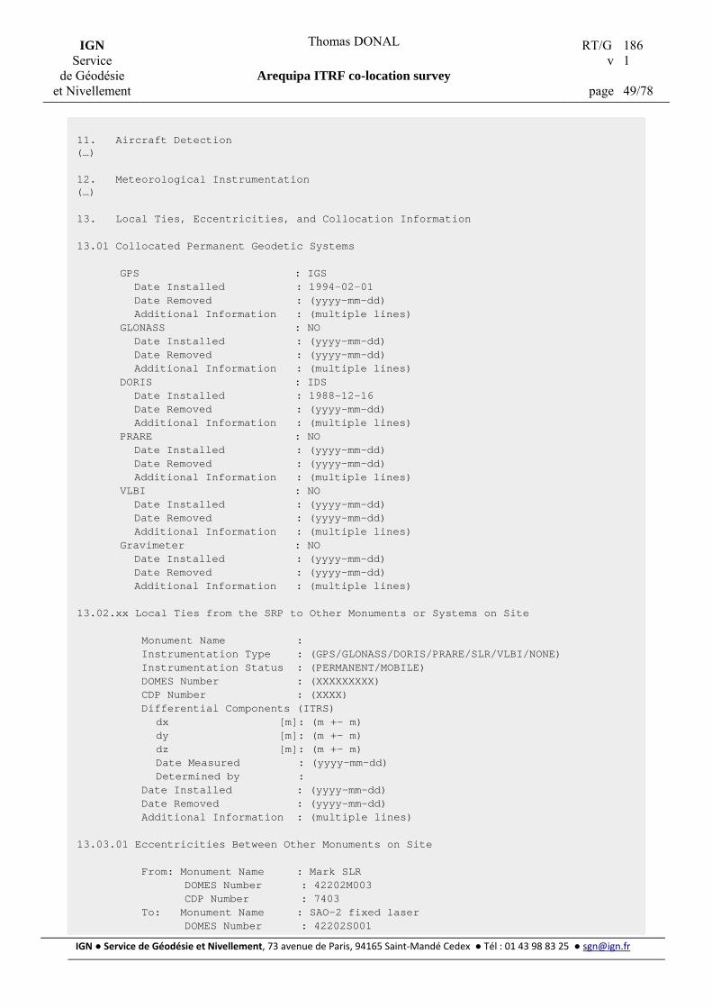
11. Aircraft Detection (…) 12. Meteorological Instrumentation (…) 13. Local Ties, Eccentricities, and Collocation Information 13.01 Collocated Permanent Geodetic Systems GPS : IGS Date Installed : 1994-02-01 Date Removed : (yyyy-mm-dd) Additional Information : (multiple lines) GLONASS : NO Date Installed : (yyyy-mm-dd) Date Removed : (yyyy-mm-dd) Additional Information : (multiple lines) DORIS : IDS Date Installed : 1988-12-16 Date Removed : (yyyy-mm-dd) Additional Information : (multiple lines) PRARE : NO Date Installed : (yyyy-mm-dd) Date Removed : (yyyy-mm-dd) Additional Information : (multiple lines) VLBI : NO Date Installed : (yyyy-mm-dd) Date Removed : (yyyy-mm-dd) Additional Information : (multiple lines) Gravimeter : NO Date Installed : (yyyy-mm-dd) Date Removed : (yyyy-mm-dd) Additional Information : (multiple lines) 13.02.xx Local Ties from the SRP to Other Monuments or Systems on Site Monument Name : Instrumentation Type : (GPS/GLONASS/DORIS/PRARE/SLR/VLBI/NONE) Instrumentation Status : (PERMANENT/MOBILE) DOMES Number : (XXXXXXXXX) CDP Number : (XXXX) Differential Components (ITRS) dx [m]: (m +- m) dy [m]: (m +- m) dz [m]: (m +- m) Date Measured : (yyyy-mm-dd) Determined by : Date Installed : (yyyy-mm-dd) Date Removed : (yyyy-mm-dd) Additional Information : (multiple lines) 13.03.01 Eccentricities Between Other Monuments on Site From: Monument Name : Mark SLR DOMES Number : 42202M003 CDP Number : 7403 To: Monument Name : SAO-2 fixed laser DOMES Number : 42202S001
IGN ● Service de Géodésie et Nivellement, 73 avenue de Paris, 94165 Saint‐Mandé Cedex ● Tél : 01 43 98 83 25 ● [email protected]

IGNService
de Géodésieet Nivellement
Thomas DONAL RT/Gv
page
1861
50/78Arequipa ITRF co-location survey
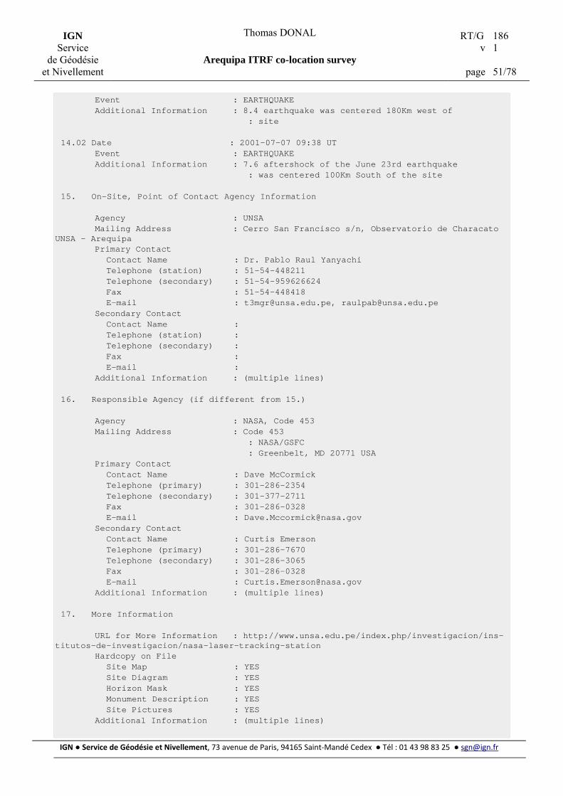
CDP Number : 7907 Differential Components (ITRS) dx [m]: -16.021 +- 0.002 dy [m]: -7.914 +- 0.002 dz [m]: -3.651 +- 0.002 Date Measured : 1994-03-18 Determined by : HTSI Additional Information : (multiple lines) 13.03.02 Eccentricities Between Other Monuments on Site From: Monument Name : Mark SLR DOMES Number : 42202M003 CDP Number : 7403 To: Monument Name : GPS marker JPL 4021-s DOMES Number : 42202M005 CDP Number : N.A. Differential Components (ITRS) dx [m]: 18.615 +- 0.002 dy [m]: -0.548 +- 0.002 dz [m]: 21.499 +- 0.002 Date Measured : 1994-03-18 Determined by : HTSI Additional Information : (multiple lines) 13.03.03 Eccentricities Between Other Monuments on Site From: Monument Name : Mark SLR DOMES Number : 42202M003 CDP Number : 7403 To: Monument Name : DORIS antenna ref. pt DOMES Number : 42202S005 CDP Number : N.A. Differential Components (ITRS) dx [m]: -11.368 +- 0.002 dy [m]: -8.020 +- 0.002 dz [m]: -3.627 +- 0.002 Date Measured : 1994-03-18 Determined by : HTSI Additional Information : (multiple lines) 13.03.03 Eccentricities Between Other Monuments on Site From: Monument Name : Mark SLR DOMES Number : 42202M003 CDP Number : 7403 To: Monument Name : DORIS antenna ref. pt DOMES Number : 42202S005 CDP Number : N.A. Differential Components (ITRS) dx [m]: dy [m]: dz [m]: Date Measured : Determined by : HTSI Additional Information : (Measurements did not occur in 2007) 14. Local Events Possibly Affecting Computed Position 14.01 Date : 2001-06-23 20:33 UT
IGN ● Service de Géodésie et Nivellement, 73 avenue de Paris, 94165 Saint‐Mandé Cedex ● Tél : 01 43 98 83 25 ● [email protected]
IGNService
de Géodésieet Nivellement
Thomas DONAL RT/Gv
page
1861
51/78Arequipa ITRF co-location survey
Event : EARTHQUAKE Additional Information : 8.4 earthquake was centered 180Km west of : site 14.02 Date : 2001-07-07 09:38 UT Event : EARTHQUAKE Additional Information : 7.6 aftershock of the June 23rd earthquake : was centered 100Km South of the site 15. On-Site, Point of Contact Agency Information Agency : UNSA Mailing Address : Cerro San Francisco s/n, Observatorio de Characato UNSA - Arequipa Primary Contact Contact Name : Dr. Pablo Raul Yanyachi Telephone (station) : 51-54-448211 Telephone (secondary) : 51-54-959626624 Fax : 51-54-448418 E-mail : [email protected], [email protected] Secondary Contact Contact Name : Telephone (station) : Telephone (secondary) : Fax : E-mail : Additional Information : (multiple lines) 16. Responsible Agency (if different from 15.) Agency : NASA, Code 453 Mailing Address : Code 453 : NASA/GSFC : Greenbelt, MD 20771 USA Primary Contact Contact Name : Dave McCormick Telephone (primary) : 301-286-2354 Telephone (secondary) : 301-377-2711 Fax : 301-286-0328 E-mail : [email protected] Secondary Contact Contact Name : Curtis Emerson Telephone (primary) : 301-286-7670 Telephone (secondary) : 301-286-3065 Fax : 301-286-0328 E-mail : [email protected] Additional Information : (multiple lines) 17. More Information URL for More Information : http://www.unsa.edu.pe/index.php/investigacion/ins-titutos-de-investigacion/nasa-laser-tracking-station Hardcopy on File Site Map : YES Site Diagram : YES Horizon Mask : YES Monument Description : YES Site Pictures : YES Additional Information : (multiple lines)
IGN ● Service de Géodésie et Nivellement, 73 avenue de Paris, 94165 Saint‐Mandé Cedex ● Tél : 01 43 98 83 25 ● [email protected]

IGNService
de Géodésieet Nivellement
Thomas DONAL RT/Gv
page
1861
52/78Arequipa ITRF co-location survey
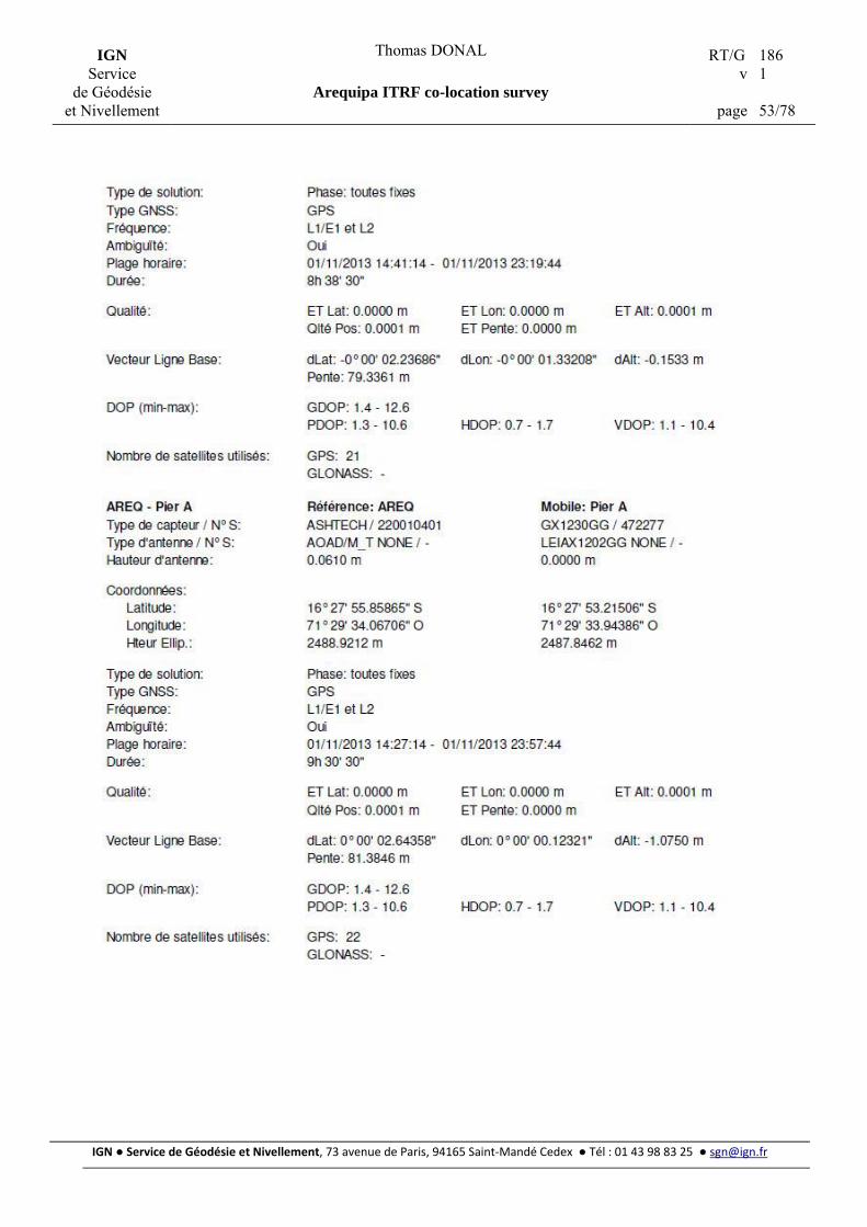
6.5. LeicaGeoOfficereportfile
IGN ● Service de Géodésie et Nivellement, 73 avenue de Paris, 94165 Saint‐Mandé Cedex ● Tél : 01 43 98 83 25 ● [email protected]
IGNService
de Géodésieet Nivellement
Thomas DONAL RT/Gv
page
1861
53/78Arequipa ITRF co-location survey
IGN ● Service de Géodésie et Nivellement, 73 avenue de Paris, 94165 Saint‐Mandé Cedex ● Tél : 01 43 98 83 25 ● [email protected]
IGNService
de Géodésieet Nivellement
Thomas DONAL RT/Gv
page
1861
54/78Arequipa ITRF co-location survey
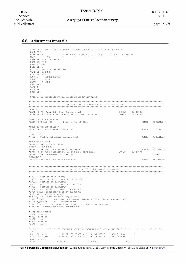
6.6. Adjustmentinputfile
TITL AREG (AREQUIPA) REGINA-DORIS-AREQ-SLR TIES - JANUARY 2013 SURVEY COMP ADJ ELIP GRS 80 6378137.000 6356752.3142 0.0000 0.0000 0.0000 m MAXI 15 CONF YES YES YES YES NO PSOL NO YES PMIS NO NO PRES YES NO PADJ NO NO YES YES YES NO VARF YES YES NO RTST TAU MAX LUNT m 1.000000000000 CONV 0.00010 CLEV 95.000 ANGT GRD LDEC 4 FCOV YES PGEO YES
GFIL D:\Logiciels\Technique\Geolab\Geoids\egm08.gsp
******************************************************************************************************* ITRF ACRONYMS, n°DOMES and POINTS DESCRIPTION ********************************************************************************************************DORIS:*ARFB: DORIS Ant. Ref. Pt. (Starec type) DOMES 42202S007*ARFB_marker: DORIS concrete pillar / domed brass mark DOMES 42202M007
*GNSS permanent station*AREQ: IGS Ref. Pt. (mark on steel disk) DOMES 42202M005
*GNSS permanent station*AREG: Ref. Pt. (domed brass mark) DOMES 42202M008
*TLRS-3 SLR*7403: TLRS-3 reference station mark DOMES 42202M003
*GEODETIC POINTS*Brass disk "BM.CHR-5 1961"DOMES 42202M001*Brass disk "Est Satellite-1961-IGM-PERU" DOMES 42202M002*Brass disk "Est Satellite-1961-IGM-PERU Mark REF1" DOMES 42202M004*Brass disk "NASA-GSFC 7403 RM2 89" DOMES42202M009*Brass disk "Aux-satellite AREQ 1958" DOMES 42202M010
******************************************************************************************************* LIST OF POINTS for the SURVEY ADJUSTMENT *******************************************************************************************************
*1002: station on 42202M004*2001: mini reflector pole on 42202M002*2002: station on 42202M002*4001: mini reflector pole on 42202M009*4002: station on 42202M009*10000: mini reflector pole on 42202M010*20000: mini reflector pole on 42202M001*AREG_ARP: AREG antenna ARP*DORIS_2GHz: DORIS antenna, upper part*TLRS-3_SRP: TLRS-3 Ranging system reference point (axis intersection)*TLRS-3_mount: TLRS-3 survey mount*TLRS-3_prism: prism or total station on TLRS-3 survey mount*101: mini-prism under AREG antenna ARP
*Temporaty points*3002: station*5002: station*6002: station*7002: station*8002: station
***************************AZIMUT DEDUCTED FROM THE GPS DETERMINATION********************************* 3DD PLH 000 AREQ S 16 27 55.85865 W 71 29 34.06706 2488.9211 m 0 PLH 000 PierA S 16 27 53.21506 W 71 29 33.94386 2487.9035 m 0 COV LG DIAG ELEM 0.000001 0.000001 0.1
IGN ● Service de Géodésie et Nivellement, 73 avenue de Paris, 94165 Saint‐Mandé Cedex ● Tél : 01 43 98 83 25 ● [email protected]

IGNService
de Géodésieet Nivellement
Thomas DONAL RT/Gv
page
1861
55/78Arequipa ITRF co-location survey
3DD PLH 000 AREQ S 16 27 55.85865 W 71 29 34.06706 2488.9211 m 0 PLH 000 PierD S 16 27 58.09551 W 71 29 35.39914 2488.8394 m 0 COV LG DIAG ELEM 0.000001 0.000001 0.1
*****************************************POINT COORDINATES*********************************************FORCED ITRF2008 EPOCH 2013:03 COORDINATES*Coordinates from igs13P1722.ssc (combinaison week 1722) 3DC XYZ 000 AREQ 1942826.225 -5804070.342 -1796894.191 m COV CT DIAG 1 ELEM 0.000001 0.000001 0.000001
***********************************APPROXIMATE COORDINATES******************************************** PLH 000 10000 S 16 27 56.19182 W 71 29 35.26263 2488.9154 m 0 PLH 000 20000 S 16 27 56.50463 W 71 29 35.46507 2488.7937 m 0 PLH 000 101 S 16 27 55.52614 W 71 29 34.45595 2489.6504 m 0 PLH 000 1002 S 16 27 56.47485 W 71 29 35.03927 2493.0426 m 0 PLH 000 2001 S 16 27 56.41538 W 71 29 35.52172 2491.5889 m 0 PLH 000 2002 S 16 27 56.41544 W 71 29 35.52172 2493.0805 m 0 PLH 000 3002 S 16 27 55.38207 W 71 29 34.32764 2489.6413 m 0 PLH 000 4001 S 16 27 55.83326 W 71 29 34.20198 2488.6731 m 0 PLH 000 4002 S 16 27 55.83329 W 71 29 34.20200 2489.8261 m 0 PLH 000 5002 S 16 27 56.70231 W 71 29 34.88787 2490.4570 m 0 PLH 000 6002 S 16 27 56.87537 W 71 29 34.36608 2490.2631 m 0 PLH 000 7002 S 16 27 56.01339 W 71 29 34.52672 2490.2199 m 0 PLH 000 8002 S 16 27 55.48980 W 71 29 34.59884 2489.5295 m 0 PLH 000 PierA S 16 27 53.21724 W 71 29 33.94478 2487.9047 m 0 PLH 000 PierB S 16 27 54.29339 W 71 29 31.99774 2489.2074 m 0 PLH 000 PierD S 16 27 58.09773 W 71 29 35.39988 2488.8414 m 0 PLH 000 AREG S 16 27 55.52613 W 71 29 34.45592 2489.3407 m 0 PLH 000 AREG_ARP S 16 27 55.52614 W 71 29 34.45594 2489.7694 m 0 PLH 000 ARFB S 16 27 56.78903 W 71 29 34.81210 2491.0037 m 0 PLH 000 ARFB_marker S 16 27 56.78902 W 71 29 34.81213 2490.3685 m 0 PLH 000 DORIS_2GHz S 16 27 56.78900 W 71 29 34.81212 2491.4749 m 0 PLH 000 TLRS-3_prism S 16 27 56.59047 W 71 29 34.65709 2491.9465 m 0 PLH 000 42202M009 S 16 27 55.83326 W 71 29 34.20200 2488.4741 m 0
****************************************CENTRING EQUATIONS********************************************
*Total station height over survey mark: 1,591m 3DD PLH 000 1002 S 16 27 56.47485 W 71 29 35.03927 2493.0426 m 0 PLH 000 42202M004 S 16 27 56.47485 W 71 29 35.03927 2491.4516 m 0 COV LG DIAG ELEM 0.000001 0.000001 0.000002
*Total station height over survey mark: 1,69m 3DD PLH 000 2002 S 16 27 56.41544 W 71 29 35.52172 2493.0805 m 0 PLH 000 42202M002 S 16 27 56.41544 W 71 29 35.52172 2491.3905 m 0 COV LG DIAG ELEM 0.000001 0.000001 0.000002
*mini reflector pole, prism height over survey mark of 20cm 3DD PLH 000 2001 S 16 27 56.41538 W 71 29 35.52172 2491.5889 m 0 PLH 000 42202M002 S 16 27 56.41544 W 71 29 35.52172 2491.3889 m 0 COV LG DIAG ELEM 0.000004 0.000004 0.0000006
*mini reflector pole, prism height over survey mark of 20cm 3DD PLH 000 4001 S 16 27 55.83326 W 71 29 34.20200 2488.6731 m 0 PLH 000 42202M009 S 16 27 55.83326 W 71 29 34.20200 2488.4731 m 0 COV LG DIAG ELEM 0.000004 0.000004 0.0000006
*Total station height over survey mark: 1,352m 3DD PLH 000 4002 S 16 27 55.83329 W 71 29 34.20200 2489.8261 m 0 PLH 000 42202M009 S 16 27 55.83326 W 71 29 34.20200 2488.4741 m 0 COV LG DIAG ELEM 0.000001 0.000001 0.000002 *mini reflector pole, prism height over survey mark of 20cm 3DD PLH 000 10000 S 16 27 56.19182 W 71 29 35.26263 2488.9154 m 0 PLH 000 42202M010 S 16 27 56.19182 W 71 29 35.26263 2488.7154 m 0 COV LG DIAG
IGN ● Service de Géodésie et Nivellement, 73 avenue de Paris, 94165 Saint‐Mandé Cedex ● Tél : 01 43 98 83 25 ● [email protected]

IGNService
de Géodésieet Nivellement
Thomas DONAL RT/Gv
page
1861
56/78Arequipa ITRF co-location survey
ELEM 0.000004 0.000004 0.0000006
*mini reflector pole, prism height over survey mark of 20cm 3DD PLH 000 20000 S 16 27 56.50463 W 71 29 35.46507 2488.7937 m 0 PLH 000 42202M001 S 16 27 56.50463 W 71 29 35.46507 2488.5937 m 0 COV LG DIAG ELEM 0.000004 0.000004 0.0000006 *vertical offset prism->ARP = 11,81cm (prism+adaptator+plaque) 3DD PLH 000 AREG_ARP S 16 27 55.52614 W 71 29 34.45595 2489.7694 m 0 PLH 000 101 S 16 27 55.52614 W 71 29 34.45595 2489.6513 m 0 COV LG DIAG ELEM 0.0000009 0.0000009 0.0000006 *vertical offset TLRS-3 survey mount-> TLRS-3 prism = 0,2385m 3DD PLH 000 TLRS-3_prism S 16 27 56.59047 W 71 29 34.65709 2491.9465 m 0 PLH 000 TLRS-3_mount S 16 27 56.59047 W 71 29 34.65709 2491.7080 m 0 COV LG DIAG ELEM 0.000001 0.000001 0.0000006 *vertical offset TLRS-3 SRP (axis)->TLRS-3 survey mount = 0.174m 3DD PLH 000 TLRS-3_mount S 16 27 56.59047 W 71 29 34.65709 2491.7080 m 0 PLH 000 TLRS-3_SRP S 16 27 56.59047 W 71 29 34.65709 2491.5340 m 0 COV LG DIAG ELEM 0.000001 0.000001 0.0000006
*Eccentricity TLRS-3 reference mark (CDP:7403)->TLRS-3 SRP (axis)*North [m]: 0.0112 +- 0.002 -> 0.0003621033" *East [m]:-0.0046 +- 0.002 ->-0.0001550809"*Up [m]: 2.6951 +- 0.002 3DD PLH 000 TLRS-3_SRP s 16 27 56.590470 w 71 29 34.657090 2491.5340 m 0 PLH 000 7403 s 16 27 56.590832 w 71 29 34.656935 2488.8389 m 0 COV LG DIAG ELEM 0.000006 0.000006 0.000006
******************************************************************************************************* Total Station Observations 2013 T.DONAL ******************************************************************************************************* *Tours d'horizon SIGM AH 8.0 HIST NEW DSET AH DIR 4002 PierA 0 0 0.0 DIR 4002 PierB 54 8 41.8 DIR 4002 1002 251 25 23.8 DIR 4002 2002 266 68 1.1 DIR 4002 3002 377 26 73.0 DIR 4002 AREG 351 11 23.4 DIR 4002 101 351 10 82.2 *DIR 4002 102 350 76 79.1 *DIR 4002 103 351 45 18.1 DIR 4002 AREG_ARP 351 10 98.6 DIR 4002 AREQ 107 51 89.1 DIR 4002 5002 235 41 37.0 DSET AH DIR 3002 PierA 0 0 0.0 DIR 3002 PierB 60 52 91.8 DIR 3002 1002 224 95 42.2 DIR 3002 2002 242 69 72.0 DIR 3002 4002 172 52 98.2 DIR 3002 AREG 234 42 82.8 DIR 3002 42202M009 172 52 67.0 DIR 3002 101 234 43 30.0 *DIR 3002 102 233 72 33.4 *DIR 3002 103 235 14 16.3 DIR 3002 AREG_ARP 234 43 24.8 DIR 3002 AREQ 158 56 82.4 DIR 3002 5002 213 97 96.9 DIR 3002 ARFB_marker 209 66 23.5 *DIR 3002 201 209 62 25.3 *DIR 3002 202 209 69 88.2 DIR 3002 ARFB 209 66 06.7 *DIR 3002 203 209 64 62.9 *DIR 3002 204 209 67 65.7 DIR 3002 DORIS_2GHz 209 66 14.3 *DIR 3002 401 205 61 54.6 *DIR 3002 402 205 61 54.8 DIR 3002 TLRS-3_prism 205 61 54.7 DSET AH
IGN ● Service de Géodésie et Nivellement, 73 avenue de Paris, 94165 Saint‐Mandé Cedex ● Tél : 01 43 98 83 25 ● [email protected]
IGNService
de Géodésieet Nivellement
Thomas DONAL RT/Gv
page
1861
57/78Arequipa ITRF co-location survey
DIR 3002 PierA 0 0 0.0 DIR 3002 4001 172 52 68.1 DSET AH DIR 3002 PierA 0 0 0.0 DIR 3002 PierD 212 41 14.2 DSET AH DIR 2002 PierA 0 0 0.0 DIR 2002 PierB 36 20 97.1 DIR 2002 1002 79 81 7.3 DIR 2002 AREQ 47 77 50.1 DIR 2002 4002 44 43 16.5 DIR 2002 3002 25 18 78.8 DIR 2002 AREG 26 33 86.8 DIR 2002 101 26 33 80.1 *DIR 2002 102 26 23 86.6 *DIR 2002 103 26 43 71.5 DIR 2002 AREG_ARP 26 33 79.0 *DIR 2002 401 84 89 33.6 *DIR 2002 402 84 89 28.6 DIR 2002 TLRS-3_prism 84 89 31.1 *DIR 2002 201 103 45 15.5 *DIR 2002 202 103 59 67.9 DIR 2002 ARFB 103 52 41.7 *DIR 2002 203 103 49 33.6 *DIR 2002 204 103 55 39.6 DIR 2002 DORIS_2GHz 103 52 41.7 DIR 2002 PierD 167 28 62.4 12 DSET AH DIR 1002 PierA 0 0 0.0 DIR 1002 PierB 39 34 97.0 DIR 1002 4002 37 31 68.9 DIR 1002 AREQ 43 13 64.4 DIR 1002 3002 15 75 95.2 DIR 1002 5002 143 69 69.3 *DIR 1002 401 99 38 45.5 *DIR 1002 402 99 38 37.3 DIR 1002 TLRS-3_prism 99 38 41.4 DIR 1002 ARFB_marker 141 26 25.1 *DIR 1002 201 141 11 8.4 *DIR 1002 202 141 40 74.1 DIR 1002 ARFB 141 25 91.2 *DIR 1002 203 141 19 60.1 *DIR 1002 204 141 31 95.8 DIR 1002 DORIS_2GHz 141 25 77.9 DIR 1002 101 14 13 15.6 *DIR 1002 102 14 0 74.5 *DIR 1002 103 14 25 32.0 DIR 1002 AREG_ARP 14 13 03.2 DIR 1002 PierD 193 48 90.7 DIR 1002 2002 288 12 26.2 DIR 1002 2001 288 12 39.6 DSET AH DIR 1002 PierA 0 0 0.0 DIR 1002 PierB 39 34 92.7 DIR 1002 AREQ 43 13 57.4 DIR 1002 5002 143 69 37.6 DIR 1002 3002 15 75 65.6 DIR 1002 ARFB_marker 141 25 97.7 *DIR 1002 201 141 11 5.3 *DIR 1002 202 141 40 59.4 DIR 1002 ARFB 141 25 82.3 *DIR 1002 203 141 19 64.7 *DIR 1002 204 141 31 95.2 DIR 1002 DORIS_2GHz 141 25 79.9 *DIR 1002 401 99 38 27.8 *DIR 1002 402 99 38 25.4 DIR 1002 TLRS-3_prism 99 38 26.6 DIR 1002 PierD 193 48 89.5 DIR 1002 2002 288 12 11.5 DIR 1002 101 14 13 0.7 *DIR 1002 102 14 0 67.1 *DIR 1002 103 14 25 21.4 DIR 1002 AREG_ARP 14 12 94.2 DIR 1002 4002 37 31 42.7 DSET AH DIR 5002 PierD 0 0 0.0 DIR 5002 1002 141 99 38.8 DIR 5002 3002 203 8 18.0 DIR 5002 101 200 1 98.1 *DIR 5002 102 199 91 22.0 *DIR 5002 103 200 12 87.2 DIR 5002 AREG_ARP 200 02 04.6 DIR 5002 4002 219 77 54.5 DIR 5002 4001 219 77 51.2 DIR 5002 ARFB_marker 333 75 52.5 *DIR 5002 201 333 25 53.7
IGN ● Service de Géodésie et Nivellement, 73 avenue de Paris, 94165 Saint‐Mandé Cedex ● Tél : 01 43 98 83 25 ● [email protected]

IGNService
de Géodésieet Nivellement
Thomas DONAL RT/Gv
page
1861
58/78Arequipa ITRF co-location survey
*DIR 5002 202 334 24 89.6 DIR 5002 ARFB 333 75 21.6 *DIR 5002 203 333 54 66.6 *DIR 5002 204 333 95 70.9 DIR 5002 DORIS_2GHz 333 75 18.7 *DIR 5002 401 248 71 26.0 *DIR 5002 402 248 70 98.4 DIR 5002 TLRS-3_prism 248 71 11.8 DSET AH DIR 6002 PierA 0 0 0.0 DIR 6002 1002 328 13 6.2 DIR 6002 2002 317 85 99.9 DIR 6002 3002 394 53 87.0 DIR 6002 AREQ 10 54 75.2 DIR 6002 4002 2 55 48.1 DIR 6002 42202M009 2 55 47.4 DIR 6002 AREG 388 87 17.0 DIR 6002 101 388 87 5.1 *DIR 6002 102 388 77 6.3 *DIR 6002 103 388 97 4.6 DIR 6002 AREG_ARP 388 87 5.4 DIR 6002 ARFB_marker 305 56 0.0 *DIR 6002 201 305 43 6.0 *DIR 6002 202 305 68 71.0 DIR 6002 ARFB 305 55 88.5 *DIR 6002 203 305 50 87.3 *DIR 6002 204 305 61 66.1 DIR 6002 DORIS_2GHz 305 56 26.7 *DIR 6002 401 343 41 55.3 *DIR 6002 402 343 41 53.1 DIR 6002 TLRS-3_prism 343 41 54.2
DSET AH DIR 6002 PierA 0 0 0.0 DIR 6002 4001 2 55 54.8 *left and right edge from antenna AREQ*DIR 6002 301 10 43 25.6 *DIR 6002 302 10 66 68.1 DIR 6002 AREQ 10 54 96.8 DSET AH DIR 6002 PierA 0 0 0.0 DIR 6002 8002 382 72 55.9 DIR 6002 7002 381 62 82.3 DSET AH DIR 7002 PierA 0 0 0.0 DIR 7002 PierB 48 29 77.1 DIR 7002 AREQ 66 30 22.9 DIR 7002 8002 378 97 29.0 DIR 7002 4002 54 17 23.6 DIR 7002 42202M009 54 16 88.5 DIR 7002 AREG 396 25 33.0 12 DIR 7002 101 396 24 89.6 *DIR 7002 102 395 97 54.0 *DIR 7002 103 396 52 41.1 DIR 7002 AREG_ARP 396 24 97.5 DIR 7002 10000 271 71 11.8 DIR 7002 1002 239 58 80.0 DIR 7002 ARFB_marker 209 10 39.4 *DIR 7002 201 209 3 29.3 *DIR 7002 202 209 16 93.7 DIR 7002 ARFB 209 10 11.5 *DIR 7002 203 209 7 62.8 *DIR 7002 204 209 13 23.7 DIR 7002 DORIS_2GHz 209 10 43.2 DIR 7002 6002 176 5 50.5 DSET AH DIR 7002 PierA 0 0 0.0 DIR 7002 4001 54 16 93.7 *DIR 7002 401 201 4 61.4 *DIR 7002 402 201 4 67.5 DIR 7002 TLRS-3_prism 201 4 64.5 DSET AH DIR 7002 PierA 0 0 0.0 DIR 7002 PierD 211 83 69.4 DSET AH DIR 8002 PierA 0 0 0.0 DIR 8002 PierB 54 43 76.8 DIR 8002 AREG 99 15 50.6 DIR 8002 101 99 16 15.8 DIR 8002 42202M009 129 30 14.2 DIR 8002 4002 129 30 18.5 DIR 8002 AREQ 122 69 53.5 DIR 8002 7002 174 34 26.5 DIR 8002 6002 172 52 45.4 DIR 8002 1002 208 68 53.6 DIR 8002 ARFB_marker 192 75 76.6
IGN ● Service de Géodésie et Nivellement, 73 avenue de Paris, 94165 Saint‐Mandé Cedex ● Tél : 01 43 98 83 25 ● [email protected]
IGNService
de Géodésieet Nivellement
Thomas DONAL RT/Gv
page
1861
59/78Arequipa ITRF co-location survey
*DIR 8002 201 192 71 17.9 *DIR 8002 202 192 79 76.8 DIR 8002 ARFB 192 75 47.3 *DIR 8002 203 192 73 90.1 *DIR 8002 204 192 77 45.7 DIR 8002 DORIS_2GHz 192 75 67.9 *DIR 8002 401 186 0 20.1 *DIR 8002 402 186 0 22.9 DIR 8002 TLRS-3_prism 186 0 21.5 DSET AH DIR 8002 PierA 0 0 0.0 DIR 8002 4001 129 29 95.6 DIR 8002 10000 229 84 16.6 DIR 8002 20000 226 61 81.3 *DIR 8002 104 98 21 27.3 *DIR 8002 105 100 10 57.9 DIR 8002 AREG_ARP 99 15 92.6 DSET AH DIR 8002 PierA 0 0 0.0 *DIR 8002 102 96 39 8.5 *DIR 8002 103 101 92 34.8 DIR 8002 AREG_ARP 99 15 71.6 *DSET AH*DIR TLRS-3_prism PierA 0 0 0.0 *DIR TLRS-3_prism PierB 40 15 13.8 *DSET AH*DIR TLRS-3_prism PierA 0 0 0.0 *DIR TLRS-3_prism PierB 40 64 24.2 HIST GEN Tours d'horizon
* Zenithales
SIGM ZA 8.0 SIGM ZB 20.0 HIST NEW
ZANG ZA 4002 PierA 101 51 29.4 ZANG ZA 4002 PierB 100 48 79.2 ZANG ZA 4002 1002 93 56 75.2 ZANG ZA 4002 2002 95 19 77.5 ZANG ZA 4002 3002 100 81 81.6 ZANG ZA 4002 AREG 102 55 62.0 ZANG ZA 4002 101 100 92 58.7 *ZANG ZA 4002 102 100 30 27.6 *ZANG ZA 4002 103 100 30 26.3 ZANG ZB 4002 AREG_ARP 100 30 27.0 ZANG ZA 4002 AREQ 113 91 48.1 ZANG ZA 4002 5002 98 80 39.9 ZANG ZA 3002 PierA 101 63 71.5 ZANG ZA 3002 PierB 100 35 93.8 ZANG ZA 3002 1002 94 55 79.7 ZANG ZA 3002 2002 95 40 81.4 ZANG ZA 3002 4002 99 18 5.1 ZANG ZA 3002 AREG 103 27 39.3 ZANG ZA 3002 42202M009 105 15 94.5 ZANG ZA 3002 101 99 90 5.0 *ZANG ZA 3002 102 98 59 54.8 *ZANG ZA 3002 103 98 59 44.4 ZANG ZB 3002 AREG_ARP 98 59 49.6 ZANG ZA 3002 AREQ 102 75 1.1 ZANG ZA 3002 5002 98 81 74.0 ZANG ZA 3002 ARFB_marker 98 98 35.7 *ZANG ZA 3002 201 98 9 75.2 *ZANG ZA 3002 202 98 9 79.8 ZANG ZA 3002 ARFB 98 9 77.5 *ZANG ZA 3002 203 97 43 9.1 *ZANG ZA 3002 204 97 43 10.8 *ZANG ZB 3002 DORIS_2GHz 97 43 10.0 *ZANG ZA 3002 401 96 18 56.9 *ZANG ZA 3002 402 96 18 57.0 ZANG ZA 3002 TLRS-3_prism 96 18 57.0 ZANG ZA 3002 PierA 101 63 56.2 ZANG ZA 3002 4001 104 28 17.7 ZANG ZA 3002 PierA 101 63 71.7 ZANG ZA 3002 PierD 100 57 0.2 ZANG ZA 2002 PierA 103 2 40.3 ZANG ZA 2002 PierB 102 0 7.4 ZANG ZA 2002 1002 100 16 65.5 ZANG ZA 2002 AREQ 105 69 11.9 ZANG ZA 2002 4002 104 80 29.5 ZANG ZA 2002 3002 104 59 23.5 ZANG ZA 2002 AREG 105 67 96.2 ZANG ZA 2002 101 105 21 18.8 *ZANG ZA 2002 102 105 3 24.2 *ZANG ZA 2002 103 105 3 23.9
IGN ● Service de Géodésie et Nivellement, 73 avenue de Paris, 94165 Saint‐Mandé Cedex ● Tél : 01 43 98 83 25 ● [email protected]
IGNService
de Géodésieet Nivellement
Thomas DONAL RT/Gv
page
1861
60/78Arequipa ITRF co-location survey
ZANG ZA 2002 AREG_ARP 105 3 24.0 *ZANG ZA 2002 401 102 75 24.9 *ZANG ZA 2002 402 102 75 22.4 ZANG ZA 2002 TLRS-3_prism 102 75 23.7 *ZANG ZA 2002 201 105 49 85.4 *ZANG ZA 2002 202 105 49 87.5 ZANG ZA 2002 ARFB 105 49 86.5 *ZANG ZA 2002 203 104 26 0.4 *ZANG ZA 2002 204 104 26 0.9 ZANG ZB 2002 DORIS_2GHz 104 26 0.6 ZANG ZA 2002 PierD 105 19 27.6 12 ZANG ZA 1002 PierA 103 10 41.0 ZANG ZA 1002 PierB 102 17 1.0 ZANG ZA 1002 4002 106 43 25.6 ZANG ZA 1002 AREQ 107 57 75.8 ZANG ZA 1002 3002 105 44 27.2 ZANG ZA 1002 5002 119 19 57.4 *ZANG ZA 1002 401 105 85 52.6 *ZANG ZA 1002 402 105 85 55.3 ZANG ZA 1002 TLRS-3_prism 105 85 53.8 ZANG ZA 1002 ARFB_marker 114 21 18.8 *ZANG ZA 1002 201 110 91 23.5 *ZANG ZA 1002 202 110 91 24.5 ZANG ZA 1002 ARFB 110 91 24.0 *ZANG ZA 1002 203 108 42 38.6 *ZANG ZA 1002 204 108 42 37.7 ZANG ZB 1002 DORIS_2GHz 108 42 38.0 ZANG ZA 1002 101 106 34 54.6 *ZANG ZA 1002 102 106 12 33.2 *ZANG ZA 1002 103 106 12 36.0 ZANG ZA 1002 AREG_ARP 106 12 34.6 ZANG ZA 1002 PierD 105 22 78.1 ZANG ZA 1002 2002 99 83 28.6 ZANG ZA 1002 2001 106 39 17.2 ZANG ZA 1002 PierA 103 10 45.5 ZANG ZA 1002 PierB 102 17 11.7 ZANG ZA 1002 AREQ 107 57 73.6 ZANG ZA 1002 5002 119 19 54.7 ZANG ZA 1002 3002 105 44 39.1 ZANG ZA 1002 ARFB_marker 114 21 24.6 *ZANG ZA 1002 201 110 91 20.5 *ZANG ZA 1002 202 110 91 19.9 ZANG ZA 1002 ARFB 110 91 20.2 *ZANG ZA 1002 203 108 39 57.2 *ZANG ZA 1002 204 108 39 56.6 *ZANG ZB 1002 DORIS_2GHz 108 39 56.9 *ZANG ZA 1002 401 105 85 56.2 *ZANG ZA 1002 402 105 85 63.8 ZANG ZA 1002 TLRS-3_prism 105 85 59.5 ZANG ZA 1002 PierD 105 22 82.7 ZANG ZA 1002 2002 99 83 30.7 ZANG ZA 1002 101 106 34 50.6 *ZANG ZA 1002 102 106 12 25.0 *ZANG ZA 1002 103 106 12 28.9 ZANG ZA 1002 AREG_ARP 106 12 27.0 ZANG ZA 1002 4002 106 43 23.4 ZANG ZA 5002 PierD 102 25 95.1 ZANG ZA 5002 1002 80 80 33.4 ZANG ZA 5002 3002 101 18 47.5 ZANG ZA 5002 101 101 33 85.3 *ZANG ZA 5002 102 101 14 6.0 *ZANG ZA 5002 103 101 14 14.3 ZANG ZA 5002 AREG_ARP 101 14 10.1 ZANG ZA 5002 4002 101 19 56.0 ZANG ZA 5002 4001 103 37 78.1 ZANG ZA 5002 ARFB_marker 101 61 32.9 *ZANG ZA 5002 201 90 9 30.0 *ZANG ZA 5002 202 90 9 39.6 *ZANG ZA 5002 ARFB 90 9 34.8 *ZANG ZA 5002 203 82 49 49.0 *ZANG ZA 5002 204 82 49 48.4 *ZANG ZA 5002 401 87 77 74.1 *ZANG ZA 5002 402 87 77 75.0 ZANG ZA 5002 TLRS-3_prism 87 77 74.6 ZANG ZA 6002 PierA 101 32 74.9 ZANG ZA 6002 1002 92 49 59.9 ZANG ZA 6002 2002 95 17 33.6 ZANG ZA 6002 3002 100 85 99.9 ZANG ZA 6002 AREQ 102 63 22.5 ZANG ZA 6002 4002 100 85 83.1 ZANG ZA 6002 42202M009 103 51 14.6 ZANG ZA 6002 AREG 101 41 27.7 ZANG ZA 6002 101 100 93 77.6 *ZANG ZA 6002 102 100 75 62.3 *ZANG ZA 6002 103 100 75 60.6 ZANG ZA 6002 AREG_ARP 100 75 61.0
IGN ● Service de Géodésie et Nivellement, 73 avenue de Paris, 94165 Saint‐Mandé Cedex ● Tél : 01 43 98 83 25 ● [email protected]

IGNService
de Géodésieet Nivellement
Thomas DONAL RT/Gv
page
1861
61/78Arequipa ITRF co-location survey
ZANG ZA 6002 ARFB_marker 99 50 36.8 *ZANG ZA 6002 201 96 50 99.0 *ZANG ZA 6002 202 96 50 93.4 ZANG ZA 6002 ARFB 96 50 96.0 *ZANG ZA 6002 203 94 26 62.2 *ZANG ZA 6002 204 94 26 62.6 *ZANG ZA 6002 401 91 34 27.6 *ZANG ZA 6002 402 91 34 26.8 ZANG ZA 6002 TLRS-3_prism 91 34 27.2 ZANG ZA 6002 PierA 101 32 66.1 ZANG ZA 6002 4001 103 12 19.6 *ZANG ZA 6002 301 102 51 46.7 *ZANG ZA 6002 302 102 51 46.7 ZANG ZA 6002 PierA 101 32 76.1 ZANG ZA 6002 8002 101 8 27.5 ZANG ZA 6002 7002 100 10 20.0 ZANG ZA 7002 PierA 101 68 3.1 ZANG ZA 7002 PierB 100 70 27.5 ZANG ZA 7002 AREQ 105 72 34.3 ZANG ZA 7002 8002 102 70 31.3 ZANG ZA 7002 4002 102 25 40.2 ZANG ZA 7002 42202M009 109 91 97.8 ZANG ZA 7002 AREG 103 69 42.7 12 ZANG ZA 7002 101 102 39 58.3 *ZANG ZA 7002 102 101 89 74.5 *ZANG ZA 7002 103 101 89 74.7 *ZANG ZA 7002 AREG_ARP 101 89 74.6 ZANG ZA 7002 10000 103 68 41.4 ZANG ZA 7002 1002 91 41 45.5 ZANG ZA 7002 ARFB_marker 99 62 71.4 *ZANG ZA 7002 201 98 2 75.5 *ZANG ZA 7002 202 98 2 80.6 ZANG ZA 7002 ARFB 98 2 78.1 *ZANG ZA 7002 203 96 84 23.3 *ZANG ZA 7002 204 96 84 21.0 ZANG ZB 7002 DORIS_2GHz 96 84 22.6 ZANG ZA 7002 6002 99 89 80.3 ZANG ZA 7002 PierA 101 67 99.5 ZANG ZA 7002 4001 108 80 44.0 * ZANG ZA 7002 401 93 96 79.5 * ZANG ZA 7002 402 93 96 74.6 ZANG ZA 7002 TLRS-3_prism 93 96 77.0 ZANG ZA 7002 PierA 101 68 11.4 ZANG ZA 7002 PierD 101 27 4.6 ZANG ZA 8002 PierA 101 42 72.2 ZANG ZA 8002 PierB 100 24 9.7 ZANG ZA 8002 AREG 102 74 3.4 ZANG ZA 8002 101 98 24 48.0 ZANG ZA 8002 42202M009 104 24 16.7 ZANG ZA 8002 4002 98 80 57.9 ZANG ZA 8002 AREQ 101 98 64.3 ZANG ZA 8002 7002 97 29 42.3 ZANG ZA 8002 6002 98 91 83.0 ZANG ZA 8002 1002 93 24 78.8 ZANG ZA 8002 ARFB_marker 98 67 91.8 *ZANG ZA 8002 201 97 67 99.8 *ZANG ZA 8002 202 97 67 98.0 ZANG ZA 8002 ARFB 97 67 98.9 *ZANG ZA 8002 203 96 93 66.8 **ZANG ZA 8002 204 96 93 69.4 ZANG ZB 8002 DORIS_2GHz 96 93 68.1 *ZANG ZA 8002 401 95 46 76.7 *ZANG ZA 8002 402 95 46 81.0 ZANG ZA 8002 TLRS-3_prism 95 46 78.9 ZANG ZA 8002 PierA 101 42 70.2 ZANG ZA 8002 4001 103 44 28.2 ZANG ZA 8002 10000 101 33 80.2 ZANG ZA 8002 20000 101 15 87.2 **ZANG ZA 8002 104 96 2 85.5 **ZANG ZA 8002 105 96 2 77.4 ZANG ZA 8002 PierA 101 42 74.3 **ZANG ZA 8002 102 95 82 91.3 **ZANG ZA 8002 103 95 82 56.5 *Station 400 instable (mount SLR).*ZANG ZA TLRS-3_prism PierA 102 43 8.2 *ZANG ZA TLRS-3_prism PierB 101 64 80.4 *ZANG ZA TLRS-3_prism PierA 102 42 98.5 *ZANG ZA TLRS-3_prism PierB 101 64 95.5 HIST GEN Zénithales
Distances
SIGM DP 0.0010 SIGM DQ 0.0015 HIST NEW
IGN ● Service de Géodésie et Nivellement, 73 avenue de Paris, 94165 Saint‐Mandé Cedex ● Tél : 01 43 98 83 25 ● [email protected]
IGNService
de Géodésieet Nivellement
Thomas DONAL RT/Gv
page
1861
62/78Arequipa ITRF co-location survey
*Distancemeter from TCRA1201 has to be checked. Some wrong distances.*wrong distance*DIST DP 4002 1 62.83263 DIST DQ 4002 PierA 80.81693 DIST DQ 4002 PierB 80.75282 DIST DP 4002 1002 31.88788 DIST DP 4002 2002 43.18137 DIST DP 4002 3002 14.36902 DIST DP 4002 101 12.08440 DIST DP 4002 5002 33.59726 DIST DP 3002 PierA 67.54216 *wrong distance*DIST DP 3002 PierB 82.81094 *DIST DP 3002 1002 3.86574 DIST DP 3002 2002 47.71994 DIST DP 3002 4002 14.36883 DIST DP 3002 101 5.84184 *wrong distance*DIST DP 3002 5002 25.89485 *DIST DP 3002 401 38.70952 *DIST DP 3002 402 38.70942 DIST DQ 3002 PierA 67.54203 DIST DP 3002 4001 14.40028 DIST DQ 3002 PierA 67.54185 DIST DQ 2002 PierA 109.02225 *wrong distance*DIST DP 2002 PierB 75.36297 DIST DP 2002 1002 14.43209 DIST DP 2002 4002 43.18130 DIST DP 2002 3002 47.72009 DIST DP 2002 101 41.94951 *DIST DP 2002 401 26.24033 *DIST DP 2002 402 26.23957 DIST DP 2002 TLRS-3_prism 26.23995 DIST DP 1002 PierA 105.42020 DIST DQ 1002 PierB 112.51865 DIST DP 1002 4002 31.88775 DIST DP 1002 3002 39.83426 DIST DP 1002 5002 8.70577 *DIST DP 1002 401 11.93602 *DIST DP 1002 402 11.93572 DIST DP 1002 TLRS-3_prism 11.93587 DIST DP 1002 101 34.09212 DIST DQ 1002 PierD 51.22333 DIST DP 1002 2002 14.43201 DIST DP 1002 2001 14.50461 DIST DQ 1002 PierA 105.42030 DIST DQ 1002 PierB 112.51834 * DIST DP 1002 401 11.93582 * DIST DP 1002 402 11.93562 DIST DP 1002 TLRS-3_prism 11.93572 DIST DP 1002 5002 8.70597 DIST DP 1002 3002 39.83436 DIST DQ 1002 PierD 51.22273 DIST DP 1002 2002 14.43171 DIST DP 1002 101 34.09152 DIST DP 1002 4002 31.88775 DIST DQ 5002 PierD 45.56123 DIST DP 5002 1002 8.70603 DIST DP 5002 3002 43.87864 DIST DP 5002 101 38.38101 DIST DP 5002 4002 33.59694 DIST DP 5002 4001 33.63909 ** DIST DP 5002 401 7.80676 ** DIST DP 5002 402 7.80661 DIST DP 5002 TLRS-3_prism 7.80668 DIST DQ 6002 PierA 113.19545 DIST DP 6002 1002 23.63188 DIST DP 6002 2002 37.20107 DIST DP 6002 3002 45.93990 DIST DP 6002 4002 32.41635 DIST DP 6002 101 41.58141 *DIST DP 6002 401 12.41581 *DIST DP 6002 402 12.41636 DIST DP 6002 TLRS-3_prism 12.41608 DIST DQ 6002 PierA 113.19550 DIST DP 6002 4001 32.45381 *wrong distance*DIST DP 6002 PierA 62.57216 *DIST DP 6002 8002 43.29669 DIST DP 6002 7002 26.93393 DIST DQ 7002 PierA 87.71941 *wrong distance*DIST DP 7002 PierB 49.63482 *DIST DP 7002 8002 16.34866
IGN ● Service de Géodésie et Nivellement, 73 avenue de Paris, 94165 Saint‐Mandé Cedex ● Tél : 01 43 98 83 25 ● [email protected]
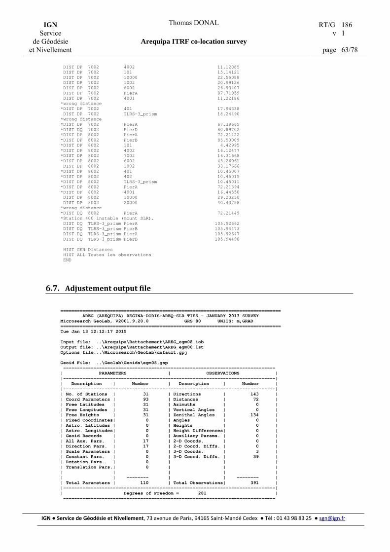
IGNService
de Géodésieet Nivellement
Thomas DONAL RT/Gv
page
1861
63/78Arequipa ITRF co-location survey
DIST DP 7002 4002 11.12085 DIST DP 7002 101 15.14121 DIST DP 7002 10000 22.55088 DIST DP 7002 1002 20.99126 DIST DP 7002 6002 26.93407 DIST DP 7002 PierA 87.71959 DIST DP 7002 4001 11.22186 *wrong distance*DIST DP 7002 401 17.94338 DIST DP 7002 TLRS-3_prism 18.24490 *wrong distance*DIST DP 7002 PierA 67.39665 *DIST DQ 7002 PierD 80.89702 *DIST DP 8002 PierA 72.21422 *DIST DP 8002 PierB 85.50009 *DIST DP 8002 101 4.42995 *DIST DP 8002 4002 16.12477 *DIST DP 8002 7002 16.31668 *DIST DP 8002 6002 43.26961 DIST DP 8002 1002 33.17666 *DIST DP 8002 401 10.45007 *DIST DP 8002 402 10.45015 *DIST DP 8002 TLRS-3_prism 10.45011 *DIST DP 8002 PierA 72.21394 *DIST DP 8002 4001 16.44550 DIST DP 8002 10000 29.23250 DIST DP 8002 20000 40.43758 *wrong distance*DIST DQ 8002 PierA 72.21449 *Station 400 instable (mount SLR). DIST DQ TLRS-3_prism PierA 105.92662 DIST DQ TLRS-3_prism PierB 105.94473 DIST DQ TLRS-3_prism PierA 105.92647 DIST DQ TLRS-3_prism PierB 105.94498 HIST GEN Distances HIST ALL Toutes les observations END
6.7. Adjustementoutputfile
================================================================================ AREG (AREQUIPA) REGINA-DORIS-AREQ-SLR TIES - JANUARY 2013 SURVEYMicrosearch GeoLab, V2001.9.20.0 GRS 80 UNITS: m,GRAD ================================================================================Tue Jan 13 12:12:17 2015
Input file: ..\Arequipa\Rattachement\AREG_egm08.iobOutput file: ..\Arequipa\Rattachement\AREG_egm08.lstOptions file:..\Microsearch\GeoLab\default.gpj
Geoid File: ..\Geolab\Geoids\egm08.gsp ----------------------------------------------------------------------------- | PARAMETERS | OBSERVATIONS ||-----------------------------------------------------------------------------|| Description | Number | Description | Number ||-----------------------------------------------------------------------------|| No. of Stations | 31 | Directions | 143 || Coord Parameters | 93 | Distances | 72 || Free Latitudes | 31 | Azimuths | 0 || Free Longitudes | 31 | Vertical Angles | 0 || Free Heights | 31 | Zenithal Angles | 134 || Fixed Coordinates| 0 | Angles | 0 || Astro. Latitudes | 0 | Heights | 0 || Astro. Longitudes| 0 | Height Differences| 0 || Geoid Records | 0 | Auxiliary Params. | 0 || All Aux. Pars. | 17 | 2-D Coords. | 0 || Direction Pars. | 17 | 2-D Coord. Diffs. | 0 || Scale Parameters | 0 | 3-D Coords. | 3 || Constant Pars. | 0 | 3-D Coord. Diffs. | 39 || Rotation Pars. | 0 | | || Translation Pars.| 0 | | || | | | || | -------- | | -------- || Total Parameters | 110 | Total Observations| 391 ||-----------------------------------------------------------------------------|| Degrees of Freedom = 281 | -----------------------------------------------------------------------------
IGN ● Service de Géodésie et Nivellement, 73 avenue de Paris, 94165 Saint‐Mandé Cedex ● Tél : 01 43 98 83 25 ● [email protected]
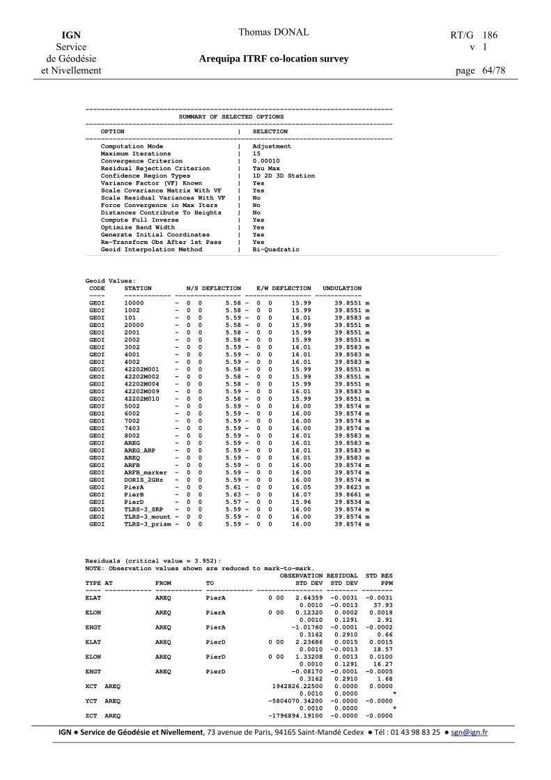
IGNService
de Géodésieet Nivellement
Thomas DONAL RT/Gv
page
1861
64/78Arequipa ITRF co-location survey
------------------------------------------------------------------------------- SUMMARY OF SELECTED OPTIONS------------------------------------------------------------------------------- OPTION | SELECTION------------------------------------------------------------------------------- Computation Mode | Adjustment Maximum Iterations | 15 Convergence Criterion | 0.00010 Residual Rejection Criterion | Tau Max Confidence Region Types | 1D 2D 3D Station Variance Factor (VF) Known | Yes Scale Covariance Matrix With VF | Yes Scale Residual Variances With VF | No Force Convergence in Max Iters | No Distances Contribute To Heights | No Compute Full Inverse | Yes Optimize Band Width | Yes Generate Initial Coordinates | Yes Re-Transform Obs After 1st Pass | Yes Geoid Interpolation Method | Bi-Quadratic
Geoid Values: CODE STATION N/S DEFLECTION E/W DEFLECTION UNDULATION ---- ------------ ----------------- ----------------- ------------ GEOI 10000 - 0 0 5.58 - 0 0 15.99 39.8551 m GEOI 1002 - 0 0 5.58 - 0 0 15.99 39.8551 m GEOI 101 - 0 0 5.59 - 0 0 16.01 39.8583 m GEOI 20000 - 0 0 5.58 - 0 0 15.99 39.8551 m GEOI 2001 - 0 0 5.58 - 0 0 15.99 39.8551 m GEOI 2002 - 0 0 5.58 - 0 0 15.99 39.8551 m GEOI 3002 - 0 0 5.59 - 0 0 16.01 39.8583 m GEOI 4001 - 0 0 5.59 - 0 0 16.01 39.8583 m GEOI 4002 - 0 0 5.59 - 0 0 16.01 39.8583 m GEOI 42202M001 - 0 0 5.58 - 0 0 15.99 39.8551 m GEOI 42202M002 - 0 0 5.58 - 0 0 15.99 39.8551 m GEOI 42202M004 - 0 0 5.58 - 0 0 15.99 39.8551 m GEOI 42202M009 - 0 0 5.59 - 0 0 16.01 39.8583 m GEOI 42202M010 - 0 0 5.58 - 0 0 15.99 39.8551 m GEOI 5002 - 0 0 5.59 - 0 0 16.00 39.8574 m GEOI 6002 - 0 0 5.59 - 0 0 16.00 39.8574 m GEOI 7002 - 0 0 5.59 - 0 0 16.00 39.8574 m GEOI 7403 - 0 0 5.59 - 0 0 16.00 39.8574 m GEOI 8002 - 0 0 5.59 - 0 0 16.01 39.8583 m GEOI AREG - 0 0 5.59 - 0 0 16.01 39.8583 m GEOI AREG_ARP - 0 0 5.59 - 0 0 16.01 39.8583 m GEOI AREQ - 0 0 5.59 - 0 0 16.01 39.8583 m GEOI ARFB - 0 0 5.59 - 0 0 16.00 39.8574 m GEOI ARFB_marker - 0 0 5.59 - 0 0 16.00 39.8574 m GEOI DORIS_2GHz - 0 0 5.59 - 0 0 16.00 39.8574 m GEOI PierA - 0 0 5.61 - 0 0 16.05 39.8623 m GEOI PierB - 0 0 5.63 - 0 0 16.07 39.8661 m GEOI PierD - 0 0 5.57 - 0 0 15.96 39.8534 m GEOI TLRS-3_SRP - 0 0 5.59 - 0 0 16.00 39.8574 m GEOI TLRS-3_mount - 0 0 5.59 - 0 0 16.00 39.8574 m GEOI TLRS-3_prism - 0 0 5.59 - 0 0 16.00 39.8574 m
Residuals (critical value = 3.952):NOTE: Observation values shown are reduced to mark-to-mark. OBSERVATION RESIDUAL STD RESTYPE AT FROM TO STD DEV STD DEV PPM---- ------------ ------------ ------------ ----------------- -------- --------ELAT AREQ PierA 0 00 2.64359 -0.0031 -0.0031 0.0010 -0.0013 37.93 ELON AREQ PierA 0 00 0.12320 0.0002 0.0018 0.0010 0.1291 2.91 EHGT AREQ PierA -1.01760 -0.0001 -0.0002 0.3162 0.2910 0.66 ELAT AREQ PierD 0 00 2.23686 0.0015 0.0015 0.0010 -0.0013 18.57 ELON AREQ PierD 0 00 1.33208 0.0013 0.0100 0.0010 0.1291 16.27 EHGT AREQ PierD -0.08170 -0.0001 -0.0005 0.3162 0.2910 1.68 XCT AREQ 1942826.22500 0.0000 0.0000 0.0010 0.0000 *YCT AREQ -5804070.34200 -0.0000 -0.0000 0.0010 0.0000 *ZCT AREQ -1796894.19100 -0.0000 -0.0000
IGN ● Service de Géodésie et Nivellement, 73 avenue de Paris, 94165 Saint‐Mandé Cedex ● Tél : 01 43 98 83 25 ● [email protected]

IGNService
de Géodésieet Nivellement
Thomas DONAL RT/Gv
page
1861
65/78Arequipa ITRF co-location survey
0.0010 0.0000 *ELAT 1002 42202M004 0 00 0.00000 -0.0000 -0.0000 0.0010 0.0000 0.00*ELON 1002 42202M004 0 00 0.00000 0.0000 0.0000 0.0010 0.0000 0.00*EHGT 1002 42202M004 -1.59100 -0.0000 -0.0000 0.0014 0.0000 0.00*ELAT 2002 42202M002 0 00 0.00000 -0.0003 -0.7776 0.0010 0.0004 194.77 ELON 2002 42202M002 0 00 0.00000 0.0001 0.1843 0.0010 0.0006 68.16 EHGT 2002 42202M002 -1.69000 -0.0013 -1.1453 0.0014 0.0011 774.17 ELAT 2001 42202M002 0 00 0.00006 0.0013 0.7916 0.0020 0.0017 6601.12 ELON 2001 42202M002 0 00 0.00000 -0.0005 -0.2834 0.0020 0.0016 2309.98 EHGT 2001 42202M002 -0.20000 0.0004 0.5408 0.0008 0.0007 1967.91 ELAT 4001 42202M009 0 00 0.00000 -0.0001 -0.0581 0.0020 0.0020 579.78 ELON 4001 42202M009 0 00 0.00000 -0.0004 -0.2112 0.0020 0.0020 2109.45 EHGT 4001 42202M009 -0.20000 0.0009 1.1916 0.0008 0.0008 4569.53 ELAT 4002 42202M009 0 00 0.00003 -0.0002 -0.1881 0.0010 0.0010 137.29 ELON 4002 42202M009 0 00 0.00000 0.0002 0.2256 0.0010 0.0010 164.77 EHGT 4002 42202M009 -1.35200 -0.0001 -0.0705 0.0014 0.0014 73.47 ELAT 10000 42202M010 0 00 0.00000 -0.0000 -0.0000 0.0020 0.0000 0.00*ELON 10000 42202M010 0 00 0.00000 0.0000 0.0000 0.0020 0.0000 0.00*EHGT 10000 42202M010 -0.20000 -0.0000 -0.0000 0.0008 0.0000 0.00*ELAT 20000 42202M001 0 00 0.00000 0.0000 0.0000 0.0020 0.0000 0.00*ELON 20000 42202M001 0 00 0.00000 -0.0000 -0.0000 0.0020 0.0000 0.00*EHGT 20000 42202M001 -0.20000 -0.0000 -0.0000 0.0008 0.0000 0.00*ELAT AREG_ARP 101 0 00 0.00000 -0.0002 -0.1966 0.0009 0.0009 1558.93 ELON AREG_ARP 101 0 00 0.00000 -0.0002 -0.1992 0.0009 0.0009 1574.76 EHGT AREG_ARP 101 -0.11810 -0.0012 -1.6165 0.0008 0.0008 10325.46 ELAT TLRS-3_prism TLRS-3_mount 0 00 0.00000 -0.0000 -0.0000 0.0010 0.0000 0.00*ELON TLRS-3_prism TLRS-3_mount 0 00 0.00000 0.0000 0.0000 0.0010 0.0000 0.00*EHGT TLRS-3_prism TLRS-3_mount -0.23850 -0.0000 -0.0000 0.0008 0.0000 0.00*ELAT TLRS-3_mount TLRS-3_SRP 0 00 0.00000 -0.0000 -0.0000 0.0010 0.0000 0.00*ELON TLRS-3_mount TLRS-3_SRP 0 00 0.00000 0.0000 0.0000 0.0010 0.0000 0.00*EHGT TLRS-3_mount TLRS-3_SRP -0.17400 0.0000 0.0000 0.0008 0.0000 0.00*ELAT TLRS-3_SRP 7403 0 00 0.00036 -0.0000 -0.0000 0.0024 0.0000 0.00*ELON TLRS-3_SRP 7403 0 00 0.00015 0.0000 0.0000 0.0024 0.0000 0.00*EHGT TLRS-3_SRP 7403 -2.69510 -0.0000 -0.0000 0.0024 0.0000 0.00*DIR 4002 PierA 0 0 0.0 -17.6 -2.5 8.0 7.0 DIR 4002 PierB 54 8 41.8 3.9 0.6 8.0 6.6 DIR 4002 1002 251 25 23.8 -1.5 -0.2 8.0 6.9 DIR 4002 2002 266 68 1.1 10.4 1.5 8.0 6.9 DIR 4002 3002 377 26 73.0 5.5 0.9 8.0 6.1 DIR 4002 AREG 351 11 23.4 1.8 0.3 8.0 6.2 DIR 4002 101 351 10 82.2 1.2 0.2 8.0 6.4 DIR 4002 AREG_ARP 351 10 98.6 -0.8 -0.1 8.0 6.3 DIR 4002 AREQ 107 51 89.1 2.0 0.9 8.0 2.2 DIR 4002 5002 235 41 37.0 -4.8 -0.7
IGN ● Service de Géodésie et Nivellement, 73 avenue de Paris, 94165 Saint‐Mandé Cedex ● Tél : 01 43 98 83 25 ● [email protected]
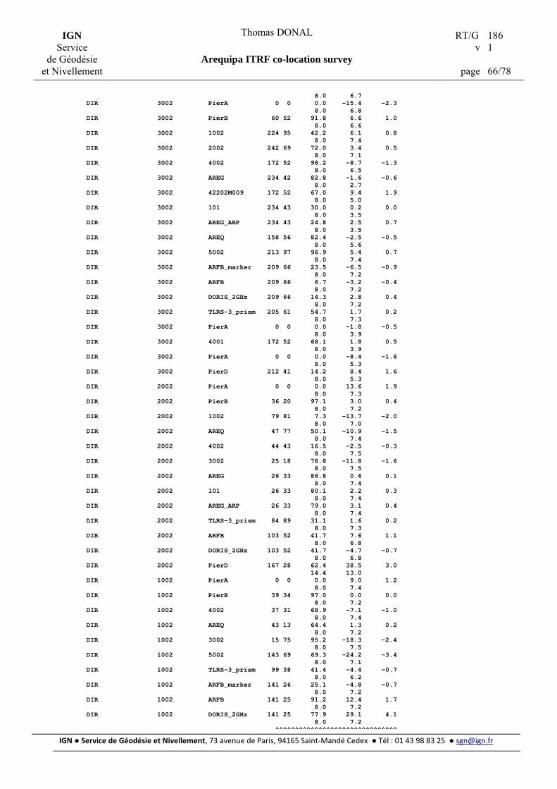
IGNService
de Géodésieet Nivellement
Thomas DONAL RT/Gv
page
1861
66/78Arequipa ITRF co-location survey
8.0 6.7 DIR 3002 PierA 0 0 0.0 -15.4 -2.3 8.0 6.8 DIR 3002 PierB 60 52 91.8 6.6 1.0 8.0 6.6 DIR 3002 1002 224 95 42.2 6.1 0.8 8.0 7.4 DIR 3002 2002 242 69 72.0 3.4 0.5 8.0 7.1 DIR 3002 4002 172 52 98.2 -8.7 -1.3 8.0 6.5 DIR 3002 AREG 234 42 82.8 -1.6 -0.6 8.0 2.7 DIR 3002 42202M009 172 52 67.0 9.4 1.9 8.0 5.0 DIR 3002 101 234 43 30.0 0.2 0.0 8.0 3.5 DIR 3002 AREG_ARP 234 43 24.8 2.5 0.7 8.0 3.5 DIR 3002 AREQ 158 56 82.4 -2.5 -0.5 8.0 5.6 DIR 3002 5002 213 97 96.9 5.4 0.7 8.0 7.4 DIR 3002 ARFB_marker 209 66 23.5 -6.5 -0.9 8.0 7.2 DIR 3002 ARFB 209 66 6.7 -3.2 -0.4 8.0 7.2 DIR 3002 DORIS_2GHz 209 66 14.3 2.8 0.4 8.0 7.2 DIR 3002 TLRS-3_prism 205 61 54.7 1.7 0.2 8.0 7.3 DIR 3002 PierA 0 0 0.0 -1.8 -0.5 8.0 3.9 DIR 3002 4001 172 52 68.1 1.8 0.5 8.0 3.9 DIR 3002 PierA 0 0 0.0 -8.4 -1.6 8.0 5.3 DIR 3002 PierD 212 41 14.2 8.4 1.6 8.0 5.3 DIR 2002 PierA 0 0 0.0 13.6 1.9 8.0 7.3 DIR 2002 PierB 36 20 97.1 3.0 0.4 8.0 7.2 DIR 2002 1002 79 81 7.3 -13.7 -2.0 8.0 7.0 DIR 2002 AREQ 47 77 50.1 -10.9 -1.5 8.0 7.4 DIR 2002 4002 44 43 16.5 -2.5 -0.3 8.0 7.5 DIR 2002 3002 25 18 78.8 -11.8 -1.6 8.0 7.5 DIR 2002 AREG 26 33 86.8 0.6 0.1 8.0 7.4 DIR 2002 101 26 33 80.1 2.2 0.3 8.0 7.4 DIR 2002 AREG_ARP 26 33 79.0 3.1 0.4 8.0 7.4 DIR 2002 TLRS-3_prism 84 89 31.1 1.6 0.2 8.0 7.3 DIR 2002 ARFB 103 52 41.7 7.6 1.1 8.0 6.8 DIR 2002 DORIS_2GHz 103 52 41.7 -4.7 -0.7 8.0 6.8 DIR 2002 PierD 167 28 62.4 38.5 3.0 14.4 13.0 DIR 1002 PierA 0 0 0.0 9.0 1.2 8.0 7.4 DIR 1002 PierB 39 34 97.0 0.0 0.0 8.0 7.2 DIR 1002 4002 37 31 68.9 -7.1 -1.0 8.0 7.4 DIR 1002 AREQ 43 13 64.4 1.3 0.2 8.0 7.2 DIR 1002 3002 15 75 95.2 -18.3 -2.4 8.0 7.5 DIR 1002 5002 143 69 69.3 -24.2 -3.4 8.0 7.1 DIR 1002 TLRS-3_prism 99 38 41.4 -4.4 -0.7 8.0 6.2 DIR 1002 ARFB_marker 141 26 25.1 -4.8 -0.7 8.0 7.2 DIR 1002 ARFB 141 25 91.2 12.4 1.7 8.0 7.2 DIR 1002 DORIS_2GHz 141 25 77.9 29.1 4.1 8.0 7.2 ^^^^^^^^^^^^^^^^^^^^^^^^^^^^^^^
IGN ● Service de Géodésie et Nivellement, 73 avenue de Paris, 94165 Saint‐Mandé Cedex ● Tél : 01 43 98 83 25 ● [email protected]

IGNService
de Géodésieet Nivellement
Thomas DONAL RT/Gv
page
1861
67/78Arequipa ITRF co-location survey
DIR 1002 101 14 13 15.6 -1.9 -0.3 8.0 7.4 DIR 1002 AREG_ARP 14 13 3.2 11.9 1.6 8.0 7.4 DIR 1002 PierD 193 48 90.7 -7.8 -1.2 8.0 6.6 DIR 1002 2002 288 12 26.2 4.4 0.7 8.0 6.3 DIR 1002 2001 288 12 39.6 0.5 0.7 8.0 0.6 DIR 1002 PierA 0 0 0.0 -4.4 -0.6 8.0 7.4 DIR 1002 PierB 39 34 92.7 -9.0 -1.3 8.0 7.2 DIR 1002 AREQ 43 13 57.4 -5.1 -0.7 8.0 7.2 DIR 1002 5002 143 69 37.6 -5.9 -0.8 8.0 7.1 DIR 1002 3002 15 75 65.6 -2.1 -0.3 8.0 7.5 DIR 1002 ARFB_marker 141 25 97.7 9.2 1.3 8.0 7.2 DIR 1002 ARFB 141 25 82.3 7.9 1.1 8.0 7.2 DIR 1002 DORIS_2GHz 141 25 79.9 13.8 1.9 8.0 7.2 DIR 1002 TLRS-3_prism 99 38 26.6 -3.0 -0.5 8.0 6.2 DIR 1002 PierD 193 48 89.5 -20.0 -3.0 8.0 6.6 DIR 1002 2002 288 12 11.5 5.7 0.9 8.0 6.3 DIR 1002 101 14 13 0.7 -0.3 -0.0 8.0 7.4 DIR 1002 AREG_ARP 14 12 94.2 7.5 1.0 8.0 7.4 DIR 1002 4002 37 31 42.7 5.7 0.8 8.0 7.4 DIR 5002 PierD 0 0 0.0 15.0 2.7 8.0 5.6 DIR 5002 1002 141 99 38.8 -8.9 -1.4 8.0 6.4 DIR 5002 3002 203 8 18.0 -2.4 -0.3 8.0 7.4 DIR 5002 101 200 1 98.1 2.9 0.4 8.0 7.3 DIR 5002 AREG_ARP 200 2 4.6 -1.6 -0.2 8.0 7.3 DIR 5002 4002 219 77 54.5 2.0 0.3 8.0 7.2 DIR 5002 4001 219 77 51.2 4.2 0.6 8.0 6.8 DIR 5002 ARFB_marker 333 75 52.5 1.7 0.6 8.0 3.1 DIR 5002 ARFB 333 75 21.6 -7.2 -2.3 8.0 3.1 DIR 5002 DORIS_2GHz 333 75 18.7 -12.0 -3.9 8.0 3.1 DIR 5002 TLRS-3_prism 248 71 11.8 6.2 2.3 8.0 2.7 DIR 6002 PierA 0 0 0.0 9.1 1.3 8.0 7.1 DIR 6002 1002 328 13 6.2 -3.3 -0.4 8.0 7.3 DIR 6002 2002 317 85 99.9 1.3 0.2 8.0 7.1 DIR 6002 3002 394 53 87.0 -17.5 -2.3 8.0 7.5 DIR 6002 AREQ 10 54 75.2 15.4 2.3 8.0 6.8 DIR 6002 4002 2 55 48.1 -0.4 -0.1 8.0 7.2 DIR 6002 42202M009 2 55 47.4 0.6 0.1 8.0 7.0 DIR 6002 AREG 388 87 17.0 -4.8 -0.7 8.0 7.4 DIR 6002 101 388 87 5.1 -5.6 -0.7 8.0 7.4 DIR 6002 AREG_ARP 388 87 5.4 -2.7 -0.4 8.0 7.4 DIR 6002 ARFB_marker 305 56 0.0 9.2 2.0 8.0 4.7 DIR 6002 ARFB 305 55 88.5 -0.8 -0.2 8.0 4.9 DIR 6002 DORIS_2GHz 305 56 26.7 -3.1 -0.6 8.0 4.9
IGN ● Service de Géodésie et Nivellement, 73 avenue de Paris, 94165 Saint‐Mandé Cedex ● Tél : 01 43 98 83 25 ● [email protected]
IGNService
de Géodésieet Nivellement
Thomas DONAL RT/Gv
page
1861
68/78Arequipa ITRF co-location survey
DIR 6002 TLRS-3_prism 343 41 54.2 2.6 0.5 8.0 5.0 DIR 6002 PierA 0 0 0.0 7.7 1.3 8.0 5.9 DIR 6002 4001 2 55 54.8 -0.1 -0.0 8.0 6.0 DIR 6002 AREQ 10 54 96.8 -7.6 -1.3 8.0 6.0 DIR 6002 PierA 0 0 0.0 5.1 0.8 8.0 6.2 DIR 6002 8002 382 72 55.9 -2.9 -0.5 8.0 6.4 DIR 6002 7002 381 62 82.3 -2.2 -0.4 8.0 6.2 DIR 7002 PierA 0 0 0.0 3.1 0.4 8.0 7.3 DIR 7002 PierB 48 29 77.1 0.6 0.1 8.0 7.0 DIR 7002 AREQ 66 30 22.9 0.4 0.1 8.0 5.7 DIR 7002 8002 378 97 29.0 -1.8 -0.3 8.0 5.8 DIR 7002 4002 54 17 23.6 0.0 0.0 8.0 5.4 DIR 7002 42202M009 54 16 88.5 3.7 1.4 8.0 2.7 DIR 7002 AREG 396 25 33.0 -11.8 -0.9 14.4 13.3 DIR 7002 101 396 24 89.6 -0.7 -0.1 8.0 6.3 DIR 7002 AREG_ARP 396 24 97.5 -1.5 -0.2 8.0 6.3 DIR 7002 10000 271 71 11.8 1.0 0.3 8.0 3.0 DIR 7002 1002 239 58 80.0 0.8 0.1 8.0 6.3 DIR 7002 ARFB_marker 209 10 39.4 -3.3 -0.5 8.0 6.1 DIR 7002 ARFB 209 10 11.5 -0.0 -0.0 8.0 6.2 DIR 7002 DORIS_2GHz 209 10 43.2 -6.9 -1.1 8.0 6.2 DIR 7002 6002 176 5 50.5 8.2 1.3 8.0 6.1 DIR 7002 PierA 0 0 0.0 -2.6 -0.5 8.0 5.1 DIR 7002 4001 54 16 93.7 -0.7 -0.2 8.0 2.9 DIR 7002 TLRS-3_prism 201 4 64.5 3.2 0.7 8.0 4.7 DIR 7002 PierA 0 0 0.0 0.2 0.0 8.0 5.3 DIR 7002 PierD 211 83 69.4 -0.2 -0.0 8.0 5.3 DIR 8002 PierA 0 0 0.0 3.5 0.5 8.0 6.5 DIR 8002 PierB 54 43 76.8 -6.8 -1.0 8.0 6.5 DIR 8002 AREG 99 15 50.6 -0.3 -0.1 8.0 2.5 DIR 8002 101 99 16 15.8 0.3 0.1 8.0 2.6 DIR 8002 42202M009 129 30 14.2 -10.3 -1.9 8.0 5.3 DIR 8002 4002 129 30 18.5 9.6 1.4 8.0 7.1 DIR 8002 AREQ 122 69 53.5 -1.0 -0.1 8.0 6.9 DIR 8002 7002 174 34 26.5 11.8 1.8 8.0 6.6 DIR 8002 6002 172 52 45.4 -2.8 -0.4 8.0 7.2 DIR 8002 1002 208 68 53.6 -1.9 -0.3 8.0 7.2 DIR 8002 ARFB_marker 192 75 76.6 -12.1 -1.7 8.0 7.2 DIR 8002 ARFB 192 75 47.3 3.0 0.4 8.0 7.2 DIR 8002 DORIS_2GHz 192 75 67.9 -4.1 -0.6 8.0 7.2 DIR 8002 TLRS-3_prism 186 0 21.5 11.1 1.6 8.0 7.0 DIR 8002 PierA 0 0 0.0 9.9 1.8 8.0 5.6 DIR 8002 4001 129 29 95.6 -0.5 -0.1 8.0 4.2
IGN ● Service de Géodésie et Nivellement, 73 avenue de Paris, 94165 Saint‐Mandé Cedex ● Tél : 01 43 98 83 25 ● [email protected]
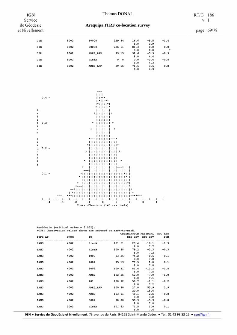
IGNService
de Géodésieet Nivellement
Thomas DONAL RT/Gv
page
1861
69/78Arequipa ITRF co-location survey
DIR 8002 10000 229 84 16.6 -5.5 -1.4 8.0 3.9 DIR 8002 20000 226 61 81.3 0.0 0.0 8.0 0.0 *DIR 8002 AREG_ARP 99 15 92.6 -3.9 -0.9 8.0 4.4 DIR 8002 PierA 0 0 0.0 -3.6 -0.8 8.0 4.3 DIR 8002 AREG_ARP 99 15 71.6 3.6 0.8 8.0 4.3
--- |:::| 0.4 - |::*** |:*:|-*- |*::|::*| *:::|:::* R |:::|:::| e *|:::|:::|* l |:::|:::| a |:::|:::| t 0.3 - * |:::|:::| * i |:::|:::| v * |:::|:::| * e |:::|:::| |:::|:::| F *---|:::|:::|---* r |:::|:::|:::|:::| e *|:::|:::|:::|:::|* q 0.2 - |:::|:::|:::|:::| u * |:::|:::|:::|:::| * e |:::|:::|:::|:::| n |:::|:::|:::|:::| c * |:::|:::|:::|:::| * y |:::|:::|:::|:::| --- * |:::|:::|:::|:::|---*:::| ---|:::|:::|:::|:::|:::|:::| 0.1 - *|:::|:::|:::|:::|:::|:::|*::| * |:::|:::|:::|:::|:::|:::|:*:| |:::|:::|:::|:::|:::|:::|:::| * |:::|:::|:::|:::|:::|:::|::*| *---|:::|:::|:::|:::|:::|:::|:::* --*|:::|:::|:::|:::|:::|:::|:::|:::|* |:*:|:::|:::|:::|:::|:::|:::|:::|:::| * --- ***::|:::|:::|:::|:::|:::|:::|:::|:::|--***-- +---+---+---+---+---+---+---+---+---+---+---+---+---+---+---+---+---+---+ -4 -3 -2 -1 0 1 2 3 4 Tours d'horizon (143 residuals)
Residuals (critical value = 3.952):NOTE: Observation values shown are reduced to mark-to-mark. OBSERVATION RESIDUAL STD RESTYPE AT FROM TO STD DEV STD DEV PPM---- ------------ ------------ ------------ ----------------- -------- --------ZANG 4002 PierA 101 51 29.4 -10.1 -1.3 8.0 7.7 ZANG 4002 PierB 100 48 79.2 -2.3 -0.3 8.0 7.2 ZANG 4002 1002 93 56 75.2 -0.6 -0.1 8.0 7.8 ZANG 4002 2002 95 19 77.5 1.0 0.1 8.0 7.8 ZANG 4002 3002 100 81 81.6 -13.2 -1.8 8.0 7.5 ZANG 4002 AREG 102 55 62.0 -7.0 -1.0 8.0 7.1 ZANG 4002 101 100 92 58.7 -1.1 -0.2 8.0 7.2 ZANG 4002 AREG_ARP 100 30 27.0 53.9 2.9 20.0 18.6 ZANG 4002 AREQ 113 91 48.1 -2.5 -0.8 8.0 3.2 ZANG 4002 5002 98 80 39.9 -5.9 -0.8 8.0 7.8 ZANG 3002 PierA 101 63 71.5 1.0 0.1 8.0 7.6
IGN ● Service de Géodésie et Nivellement, 73 avenue de Paris, 94165 Saint‐Mandé Cedex ● Tél : 01 43 98 83 25 ● [email protected]
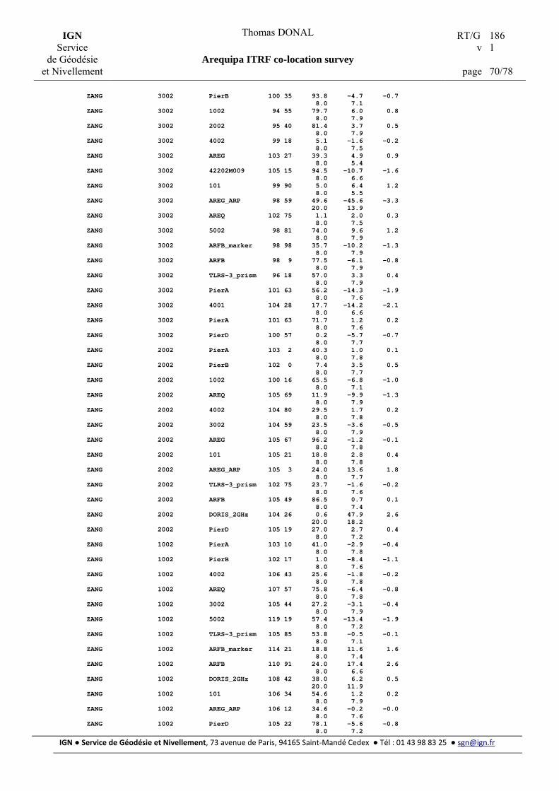
IGNService
de Géodésieet Nivellement
Thomas DONAL RT/Gv
page
1861
70/78Arequipa ITRF co-location survey
ZANG 3002 PierB 100 35 93.8 -4.7 -0.7 8.0 7.1 ZANG 3002 1002 94 55 79.7 6.0 0.8 8.0 7.9 ZANG 3002 2002 95 40 81.4 3.7 0.5 8.0 7.9 ZANG 3002 4002 99 18 5.1 -1.6 -0.2 8.0 7.5 ZANG 3002 AREG 103 27 39.3 4.9 0.9 8.0 5.4 ZANG 3002 42202M009 105 15 94.5 -10.7 -1.6 8.0 6.6 ZANG 3002 101 99 90 5.0 6.4 1.2 8.0 5.5 ZANG 3002 AREG_ARP 98 59 49.6 -45.6 -3.3 20.0 13.9 ZANG 3002 AREQ 102 75 1.1 2.0 0.3 8.0 7.5 ZANG 3002 5002 98 81 74.0 9.6 1.2 8.0 7.9 ZANG 3002 ARFB_marker 98 98 35.7 -10.2 -1.3 8.0 7.9 ZANG 3002 ARFB 98 9 77.5 -6.1 -0.8 8.0 7.9 ZANG 3002 TLRS-3_prism 96 18 57.0 3.3 0.4 8.0 7.9 ZANG 3002 PierA 101 63 56.2 -14.3 -1.9 8.0 7.6 ZANG 3002 4001 104 28 17.7 -14.2 -2.1 8.0 6.6 ZANG 3002 PierA 101 63 71.7 1.2 0.2 8.0 7.6 ZANG 3002 PierD 100 57 0.2 -5.7 -0.7 8.0 7.7 ZANG 2002 PierA 103 2 40.3 1.0 0.1 8.0 7.8 ZANG 2002 PierB 102 0 7.4 3.5 0.5 8.0 7.7 ZANG 2002 1002 100 16 65.5 -6.8 -1.0 8.0 7.1 ZANG 2002 AREQ 105 69 11.9 -9.9 -1.3 8.0 7.9 ZANG 2002 4002 104 80 29.5 1.7 0.2 8.0 7.8 ZANG 2002 3002 104 59 23.5 -3.6 -0.5 8.0 7.9 ZANG 2002 AREG 105 67 96.2 -1.2 -0.1 8.0 7.8 ZANG 2002 101 105 21 18.8 2.8 0.4 8.0 7.8 ZANG 2002 AREG_ARP 105 3 24.0 13.6 1.8 8.0 7.7 ZANG 2002 TLRS-3_prism 102 75 23.7 -1.6 -0.2 8.0 7.6 ZANG 2002 ARFB 105 49 86.5 0.7 0.1 8.0 7.4 ZANG 2002 DORIS_2GHz 104 26 0.6 47.9 2.6 20.0 18.2 ZANG 2002 PierD 105 19 27.0 2.7 0.4 8.0 7.2 ZANG 1002 PierA 103 10 41.0 -2.9 -0.4 8.0 7.8 ZANG 1002 PierB 102 17 1.0 -8.4 -1.1 8.0 7.6 ZANG 1002 4002 106 43 25.6 -1.8 -0.2 8.0 7.8 ZANG 1002 AREQ 107 57 75.8 -6.4 -0.8 8.0 7.8 ZANG 1002 3002 105 44 27.2 -3.1 -0.4 8.0 7.9 ZANG 1002 5002 119 19 57.4 -13.4 -1.9 8.0 7.2 ZANG 1002 TLRS-3_prism 105 85 53.8 -0.5 -0.1 8.0 7.1 ZANG 1002 ARFB_marker 114 21 18.8 11.6 1.6 8.0 7.4 ZANG 1002 ARFB 110 91 24.0 17.4 2.6 8.0 6.6 ZANG 1002 DORIS_2GHz 108 42 38.0 6.2 0.5 20.0 11.9 ZANG 1002 101 106 34 54.6 1.2 0.2 8.0 7.9 ZANG 1002 AREG_ARP 106 12 34.6 -0.2 -0.0 8.0 7.6 ZANG 1002 PierD 105 22 78.1 -5.6 -0.8 8.0 7.2
IGN ● Service de Géodésie et Nivellement, 73 avenue de Paris, 94165 Saint‐Mandé Cedex ● Tél : 01 43 98 83 25 ● [email protected]

IGNService
de Géodésieet Nivellement
Thomas DONAL RT/Gv
page
1861
71/78Arequipa ITRF co-location survey
ZANG 1002 2002 99 83 28.6 -0.5 -0.1 8.0 7.1 ZANG 1002 2001 106 39 17.2 1.0 1.1 8.0 0.9 ZANG 1002 PierA 103 10 45.5 1.6 0.2 8.0 7.8 ZANG 1002 PierB 102 17 11.7 2.3 0.3 8.0 7.6 ZANG 1002 AREQ 107 57 73.6 -8.6 -1.1 8.0 7.8 ZANG 1002 5002 119 19 54.7 -16.1 -2.2 8.0 7.2 ZANG 1002 3002 105 44 39.1 8.8 1.1 8.0 7.9 ZANG 1002 ARFB_marker 114 21 24.6 17.4 2.3 8.0 7.4 ZANG 1002 ARFB 110 91 20.2 13.6 2.1 8.0 6.6 ZANG 1002 TLRS-3_prism 105 85 59.5 5.2 0.7 8.0 7.1 ZANG 1002 PierD 105 22 82.7 -1.0 -0.1 8.0 7.2 ZANG 1002 2002 99 83 30.7 1.6 0.2 8.0 7.1 ZANG 1002 101 106 34 50.6 -2.8 -0.4 8.0 7.9 ZANG 1002 AREG_ARP 106 12 27.0 -7.8 -1.0 8.0 7.6 ZANG 1002 4002 106 43 23.4 -4.0 -0.5 8.0 7.8 ZANG 5002 PierD 102 25 95.1 3.7 0.5 8.0 6.9 ZANG 5002 1002 80 80 33.4 3.4 0.5 8.0 7.2 ZANG 5002 3002 101 18 47.5 7.5 1.0 8.0 7.9 ZANG 5002 101 101 33 85.3 2.3 0.3 8.0 7.9 ZANG 5002 AREG_ARP 101 14 10.1 6.2 0.8 8.0 7.6 ZANG 5002 4002 101 19 56.0 -1.5 -0.2 8.0 7.8 ZANG 5002 4001 103 37 78.1 0.0 0.0 8.0 7.7 ZANG 5002 ARFB_marker 101 61 32.9 -9.9 -3.2 8.0 3.1 ZANG 5002 TLRS-3_prism 87 77 74.6 -9.2 -1.6 8.0 5.8 ZANG 6002 PierA 101 32 74.9 5.2 0.7 8.0 7.8 ZANG 6002 1002 92 49 59.9 9.9 1.3 8.0 7.7 ZANG 6002 2002 95 17 33.6 -8.1 -1.0 8.0 7.8 ZANG 6002 3002 100 85 99.9 -22.1 -2.8 8.0 7.9 ZANG 6002 AREQ 102 63 22.5 7.8 1.0 8.0 7.7 ZANG 6002 4002 100 85 83.1 -2.0 -0.3 8.0 7.8 ZANG 6002 42202M009 103 51 14.6 9.2 1.2 8.0 7.6 ZANG 6002 AREG 101 41 27.7 1.4 0.2 8.0 7.9 ZANG 6002 101 100 93 77.6 -7.1 -0.9 8.0 7.9 ZANG 6002 AREG_ARP 100 75 61.0 3.3 0.4 8.0 7.7 ZANG 6002 ARFB_marker 99 50 36.8 7.4 1.1 8.0 6.8 ZANG 6002 ARFB 96 50 96.0 -18.5 -2.9 8.0 6.4 ZANG 6002 TLRS-3_prism 91 34 27.2 2.3 0.4 8.0 6.5 ZANG 6002 PierA 101 32 66.1 -3.6 -0.5 8.0 7.8 ZANG 6002 4001 103 12 19.6 13.9 1.8 8.0 7.6 ZANG 6002 PierA 101 32 76.1 6.4 0.8 8.0 7.8 ZANG 6002 8002 101 8 27.5 5.3 0.7 8.0 7.9 ZANG 6002 7002 100 10 20.0 -2.4 -0.3 8.0 7.7 ZANG 7002 PierA 101 68 3.1 -4.9 -0.6 8.0 7.8
IGN ● Service de Géodésie et Nivellement, 73 avenue de Paris, 94165 Saint‐Mandé Cedex ● Tél : 01 43 98 83 25 ● [email protected]
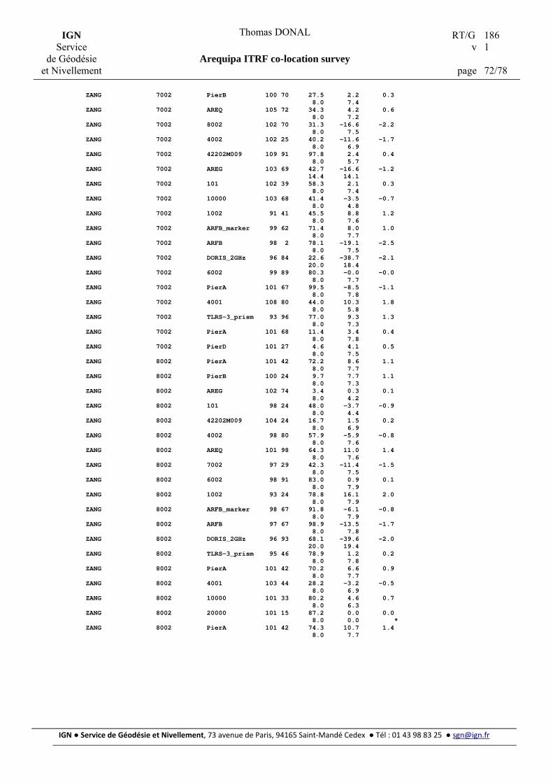
IGNService
de Géodésieet Nivellement
Thomas DONAL RT/Gv
page
1861
72/78Arequipa ITRF co-location survey
ZANG 7002 PierB 100 70 27.5 2.2 0.3 8.0 7.4 ZANG 7002 AREQ 105 72 34.3 4.2 0.6 8.0 7.2 ZANG 7002 8002 102 70 31.3 -16.6 -2.2 8.0 7.5 ZANG 7002 4002 102 25 40.2 -11.6 -1.7 8.0 6.9 ZANG 7002 42202M009 109 91 97.8 2.4 0.4 8.0 5.7 ZANG 7002 AREG 103 69 42.7 -16.6 -1.2 14.4 14.1 ZANG 7002 101 102 39 58.3 2.1 0.3 8.0 7.4 ZANG 7002 10000 103 68 41.4 -3.5 -0.7 8.0 4.8 ZANG 7002 1002 91 41 45.5 8.8 1.2 8.0 7.6 ZANG 7002 ARFB_marker 99 62 71.4 8.0 1.0 8.0 7.7 ZANG 7002 ARFB 98 2 78.1 -19.1 -2.5 8.0 7.5 ZANG 7002 DORIS_2GHz 96 84 22.6 -38.7 -2.1 20.0 18.4 ZANG 7002 6002 99 89 80.3 -0.0 -0.0 8.0 7.7 ZANG 7002 PierA 101 67 99.5 -8.5 -1.1 8.0 7.8 ZANG 7002 4001 108 80 44.0 10.3 1.8 8.0 5.8 ZANG 7002 TLRS-3_prism 93 96 77.0 9.3 1.3 8.0 7.3 ZANG 7002 PierA 101 68 11.4 3.4 0.4 8.0 7.8 ZANG 7002 PierD 101 27 4.6 4.1 0.5 8.0 7.5 ZANG 8002 PierA 101 42 72.2 8.6 1.1 8.0 7.7 ZANG 8002 PierB 100 24 9.7 7.7 1.1 8.0 7.3 ZANG 8002 AREG 102 74 3.4 0.3 0.1 8.0 4.2 ZANG 8002 101 98 24 48.0 -3.7 -0.9 8.0 4.4 ZANG 8002 42202M009 104 24 16.7 1.5 0.2 8.0 6.9 ZANG 8002 4002 98 80 57.9 -5.9 -0.8 8.0 7.6 ZANG 8002 AREQ 101 98 64.3 11.0 1.4 8.0 7.6 ZANG 8002 7002 97 29 42.3 -11.4 -1.5 8.0 7.5 ZANG 8002 6002 98 91 83.0 0.9 0.1 8.0 7.9 ZANG 8002 1002 93 24 78.8 16.1 2.0 8.0 7.9 ZANG 8002 ARFB_marker 98 67 91.8 -6.1 -0.8 8.0 7.9 ZANG 8002 ARFB 97 67 98.9 -13.5 -1.7 8.0 7.8 ZANG 8002 DORIS_2GHz 96 93 68.1 -39.6 -2.0 20.0 19.4 ZANG 8002 TLRS-3_prism 95 46 78.9 1.2 0.2 8.0 7.8 ZANG 8002 PierA 101 42 70.2 6.6 0.9 8.0 7.7 ZANG 8002 4001 103 44 28.2 -3.2 -0.5 8.0 6.9 ZANG 8002 10000 101 33 80.2 4.6 0.7 8.0 6.3 ZANG 8002 20000 101 15 87.2 0.0 0.0 8.0 0.0 *ZANG 8002 PierA 101 42 74.3 10.7 1.4 8.0 7.7
IGN ● Service de Géodésie et Nivellement, 73 avenue de Paris, 94165 Saint‐Mandé Cedex ● Tél : 01 43 98 83 25 ● [email protected]
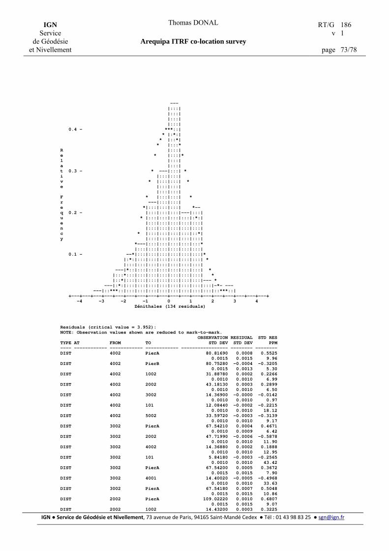
IGNService
de Géodésieet Nivellement
Thomas DONAL RT/Gv
page
1861
73/78Arequipa ITRF co-location survey
--- |:::| |:::| |:::| |:::| 0.4 - ***::| * |:*:| * |::*| * |:::* R |:::| e * |:::|* l |:::| a |:::| t 0.3 - * ---|:::| * i |:::|:::| v * |:::|:::| * e |:::|:::| |:::|:::| F * |:::|:::| * r ---|:::|:::| e *|:::|:::|:::| *-- q 0.2 - |:::|:::|:::|---|:::| u * |:::|:::|:::|:::|:*:| e |:::|:::|:::|:::|:::| n |:::|:::|:::|:::|:::| c * |:::|:::|:::|:::|::*| y |:::|:::|:::|:::|:::| *---|:::|:::|:::|:::|:::* |:::|:::|:::|:::|:::|:::| 0.1 - --*|:::|:::|:::|:::|:::|:::|* |:*:|:::|:::|:::|:::|:::|:::| * |:::|:::|:::|:::|:::|:::|:::| ---|*::|:::|:::|:::|:::|:::|:::| * |:::*:::|:::|:::|:::|:::|:::|:::| * |::*|:::|:::|:::|:::|:::|:::|:::|--- * ---|:*:|:::|:::|:::|:::|:::|:::|:::|:::|-*- --- ---|::***::|:::|:::|:::|:::|:::|:::|:::|:::|::***::| +---+---+---+---+---+---+---+---+---+---+---+---+---+---+---+---+---+---+ -4 -3 -2 -1 0 1 2 3 4 Zénithales (134 residuals)
Residuals (critical value = 3.952):NOTE: Observation values shown are reduced to mark-to-mark. OBSERVATION RESIDUAL STD RESTYPE AT FROM TO STD DEV STD DEV PPM---- ------------ ------------ ------------ ----------------- -------- --------DIST 4002 PierA 80.81690 0.0008 0.5525 0.0015 0.0015 9.96 DIST 4002 PierB 80.75280 -0.0004 -0.3205 0.0015 0.0013 5.30 DIST 4002 1002 31.88780 0.0002 0.2266 0.0010 0.0010 6.99 DIST 4002 2002 43.18130 0.0003 0.2899 0.0010 0.0010 6.50 DIST 4002 3002 14.36900 -0.0000 -0.0142 0.0010 0.0010 0.97 DIST 4002 101 12.08440 -0.0002 -0.2215 0.0010 0.0010 18.12 DIST 4002 5002 33.59720 -0.0003 -0.3139 0.0010 0.0010 9.17 DIST 3002 PierA 67.54210 0.0004 0.4671 0.0010 0.0009 6.42 DIST 3002 2002 47.71990 -0.0006 -0.5878 0.0010 0.0010 11.90 DIST 3002 4002 14.36880 0.0002 0.1888 0.0010 0.0010 12.95 DIST 3002 101 5.84180 -0.0003 -0.2565 0.0010 0.0010 43.42 DIST 3002 PierA 67.54200 0.0005 0.3672 0.0015 0.0015 7.90 DIST 3002 4001 14.40020 -0.0005 -0.4968 0.0010 0.0010 33.63 DIST 3002 PierA 67.54180 0.0007 0.5048 0.0015 0.0015 10.86 DIST 2002 PierA 109.02220 0.0010 0.6807 0.0015 0.0015 9.07 DIST 2002 1002 14.43200 0.0003 0.3225
IGN ● Service de Géodésie et Nivellement, 73 avenue de Paris, 94165 Saint‐Mandé Cedex ● Tél : 01 43 98 83 25 ● [email protected]
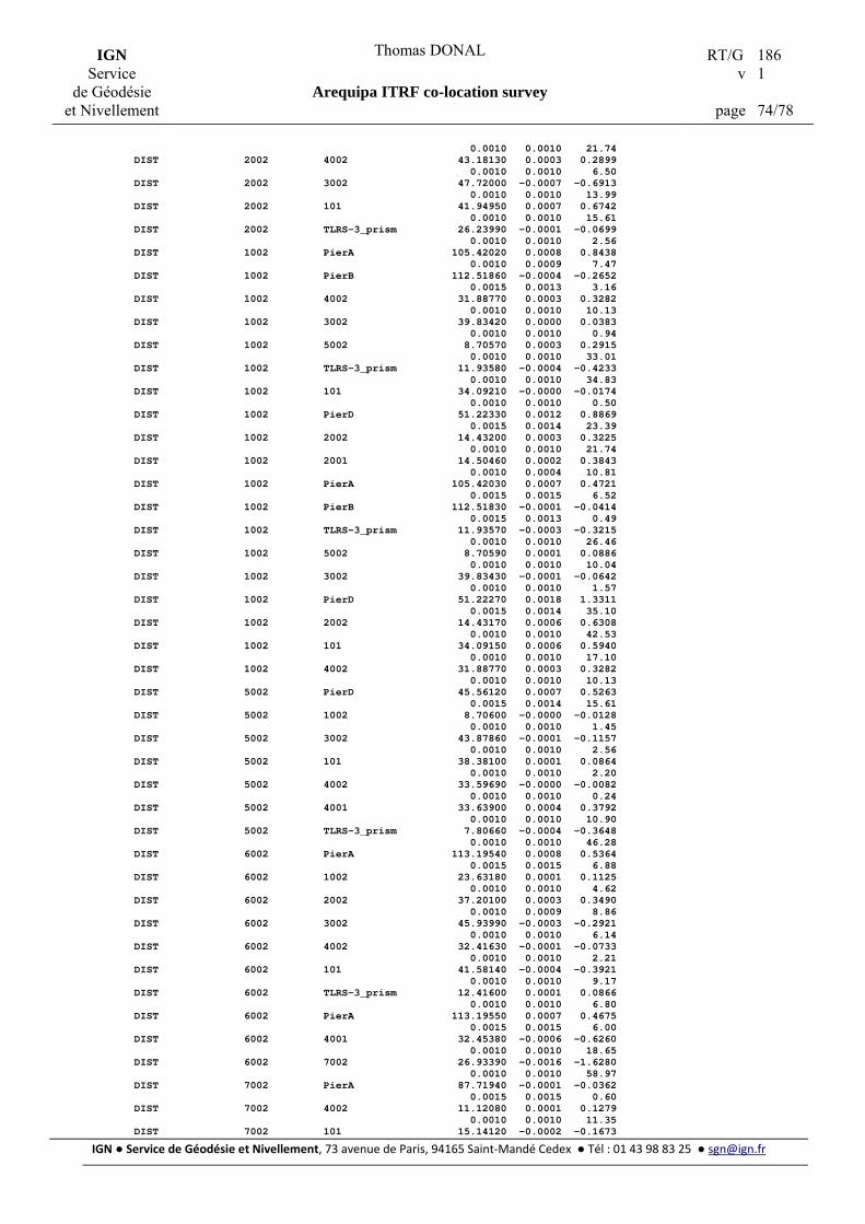
IGNService
de Géodésieet Nivellement
Thomas DONAL RT/Gv
page
1861
74/78Arequipa ITRF co-location survey
0.0010 0.0010 21.74 DIST 2002 4002 43.18130 0.0003 0.2899 0.0010 0.0010 6.50 DIST 2002 3002 47.72000 -0.0007 -0.6913 0.0010 0.0010 13.99 DIST 2002 101 41.94950 0.0007 0.6742 0.0010 0.0010 15.61 DIST 2002 TLRS-3_prism 26.23990 -0.0001 -0.0699 0.0010 0.0010 2.56 DIST 1002 PierA 105.42020 0.0008 0.8438 0.0010 0.0009 7.47 DIST 1002 PierB 112.51860 -0.0004 -0.2652 0.0015 0.0013 3.16 DIST 1002 4002 31.88770 0.0003 0.3282 0.0010 0.0010 10.13 DIST 1002 3002 39.83420 0.0000 0.0383 0.0010 0.0010 0.94 DIST 1002 5002 8.70570 0.0003 0.2915 0.0010 0.0010 33.01 DIST 1002 TLRS-3_prism 11.93580 -0.0004 -0.4233 0.0010 0.0010 34.83 DIST 1002 101 34.09210 -0.0000 -0.0174 0.0010 0.0010 0.50 DIST 1002 PierD 51.22330 0.0012 0.8869 0.0015 0.0014 23.39 DIST 1002 2002 14.43200 0.0003 0.3225 0.0010 0.0010 21.74 DIST 1002 2001 14.50460 0.0002 0.3843 0.0010 0.0004 10.81 DIST 1002 PierA 105.42030 0.0007 0.4721 0.0015 0.0015 6.52 DIST 1002 PierB 112.51830 -0.0001 -0.0414 0.0015 0.0013 0.49 DIST 1002 TLRS-3_prism 11.93570 -0.0003 -0.3215 0.0010 0.0010 26.46 DIST 1002 5002 8.70590 0.0001 0.0886 0.0010 0.0010 10.04 DIST 1002 3002 39.83430 -0.0001 -0.0642 0.0010 0.0010 1.57 DIST 1002 PierD 51.22270 0.0018 1.3311 0.0015 0.0014 35.10 DIST 1002 2002 14.43170 0.0006 0.6308 0.0010 0.0010 42.53 DIST 1002 101 34.09150 0.0006 0.5940 0.0010 0.0010 17.10 DIST 1002 4002 31.88770 0.0003 0.3282 0.0010 0.0010 10.13 DIST 5002 PierD 45.56120 0.0007 0.5263 0.0015 0.0014 15.61 DIST 5002 1002 8.70600 -0.0000 -0.0128 0.0010 0.0010 1.45 DIST 5002 3002 43.87860 -0.0001 -0.1157 0.0010 0.0010 2.56 DIST 5002 101 38.38100 0.0001 0.0864 0.0010 0.0010 2.20 DIST 5002 4002 33.59690 -0.0000 -0.0082 0.0010 0.0010 0.24 DIST 5002 4001 33.63900 0.0004 0.3792 0.0010 0.0010 10.90 DIST 5002 TLRS-3_prism 7.80660 -0.0004 -0.3648 0.0010 0.0010 46.28 DIST 6002 PierA 113.19540 0.0008 0.5364 0.0015 0.0015 6.88 DIST 6002 1002 23.63180 0.0001 0.1125 0.0010 0.0010 4.62 DIST 6002 2002 37.20100 0.0003 0.3490 0.0010 0.0009 8.86 DIST 6002 3002 45.93990 -0.0003 -0.2921 0.0010 0.0010 6.14 DIST 6002 4002 32.41630 -0.0001 -0.0733 0.0010 0.0010 2.21 DIST 6002 101 41.58140 -0.0004 -0.3921 0.0010 0.0010 9.17 DIST 6002 TLRS-3_prism 12.41600 0.0001 0.0866 0.0010 0.0010 6.80 DIST 6002 PierA 113.19550 0.0007 0.4675 0.0015 0.0015 6.00 DIST 6002 4001 32.45380 -0.0006 -0.6260 0.0010 0.0010 18.65 DIST 6002 7002 26.93390 -0.0016 -1.6280 0.0010 0.0010 58.97 DIST 7002 PierA 87.71940 -0.0001 -0.0362 0.0015 0.0015 0.60 DIST 7002 4002 11.12080 0.0001 0.1279 0.0010 0.0010 11.35 DIST 7002 101 15.14120 -0.0002 -0.1673
IGN ● Service de Géodésie et Nivellement, 73 avenue de Paris, 94165 Saint‐Mandé Cedex ● Tél : 01 43 98 83 25 ● [email protected]

IGNService
de Géodésieet Nivellement
Thomas DONAL RT/Gv
page
1861
75/78Arequipa ITRF co-location survey
0.0010 0.0010 10.86 DIST 7002 10000 22.55080 0.0027 3.4223 0.0010 0.0008 120.45 DIST 7002 1002 20.99120 0.0007 0.6969 0.0010 0.0010 32.58 DIST 7002 6002 26.93400 -0.0017 -1.7305 0.0010 0.0010 62.68 DIST 7002 PierA 87.71950 -0.0002 -0.1642 0.0010 0.0009 1.74 DIST 7002 4001 11.22180 0.0003 0.2600 0.0010 0.0010 22.57 DIST 7002 TLRS-3_prism 18.24490 -0.0001 -0.1233 0.0010 0.0010 6.63 DIST 8002 1002 33.17660 0.0011 1.1048 0.0010 0.0010 32.69 DIST 8002 10000 29.23250 -0.0020 -2.4670 0.0010 0.0008 68.77 DIST 8002 20000 40.43750 0.0000 0.0000 0.0010 0.0000 0.00*DIST TLRS-3_prism PierA 105.92660 0.0002 0.1387 0.0015 0.0015 1.91 DIST TLRS-3_prism PierB 105.94470 0.0006 0.4153 0.0015 0.0013 5.27 DIST TLRS-3_prism PierA 105.92640 0.0004 0.2761 0.0015 0.0015 3.79 DIST TLRS-3_prism PierB 105.94490 0.0004 0.2664 0.0015 0.0013 3.38
--- --- |:::|:::| |:::|:::| |:::|:::| |:::|:::| |:::|:::| |:::|:::| |:::|:::| |:::|:::| |:::|:::| |:::|:::| |:::|:::| |:::|:::| 0.4 - |::***::| |:*:|:*:| |*::|::*| *:::|:::* R |:::|:::| e *|:::|:::|* l |:::|:::| a |:::|:::| t 0.3 - * |:::|:::|-*- i |:::|:::|:::| v * |:::|:::|::*| e |:::|:::|:::| |:::|:::|:::| F * |:::|:::|:::* r |:::|:::|:::| e * |:::|:::|:::|* q 0.2 - |:::|:::|:::| u * |:::|:::|:::| * e |:::|:::|:::| n |:::|:::|:::| c * |:::|:::|:::| * y |:::|:::|:::| * |:::|:::|:::| * |:::|:::|:::| 0.1 - * |:::|:::|:::| * * |:::|:::|:::| * |:::|:::|:::| * ---|:::|:::|:::| * * |:::|:::|:::|:::| * * --- |:::|:::|:::|:::|--- * * |:::| |:::|:::|:::|:::|:::| * ***--|:::| |:::|:::|:::|:::|:::| *** --- +---+---+---+---+---+---+---+---+---+---+---+---+---+---+---+---+---+---+ -4 -3 -2 -1 0 1 2 3 4 Distances (72 residuals)
IGN ● Service de Géodésie et Nivellement, 73 avenue de Paris, 94165 Saint‐Mandé Cedex ● Tél : 01 43 98 83 25 ● [email protected]

IGNService
de Géodésieet Nivellement
Thomas DONAL RT/Gv
page
1861
76/78Arequipa ITRF co-location survey
--- |:::| |:::| |:::| |:::| |:::| |:::| |:::| |:::| |:::| |:::| ---|:::| |:::|:::| 0.4 - |::***::| |:*:|:*:| |*::|::*| *:::|:::* R |:::|:::| e *|:::|:::|* l |:::|:::| a |:::|:::| t 0.3 - * |:::|:::| * i |:::|:::| v * |:::|:::| * e |:::|:::| |:::|:::| F * |:::|:::| * r |:::|:::| e * |:::|:::|--- * q 0.2 - |:::|:::|:::| u * ---|:::|:::|:::| * e |:::|:::|:::|:::| n |:::|:::|:::|:::| c * |:::|:::|:::|:::| * y |:::|:::|:::|:::| * |:::|:::|:::|:::|---* |:::|:::|:::|:::|:::| 0.1 - * |:::|:::|:::|:::|:::|* * ---|:::|:::|:::|:::|:::| * |:::|:::|:::|:::|:::|:::| *--|:::|:::|:::|:::|:::|:::|--* *:::|:::|:::|:::|:::|:::|:::|:::* --*|:::|:::|:::|:::|:::|:::|:::|:::|* |:*:|:::|:::|:::|:::|:::|:::|:::|:::| * ***::|:::|:::|:::|:::|:::|:::|:::|:::|--***-- +---+---+---+---+---+---+---+---+---+---+---+---+---+---+---+---+---+---+ -4 -3 -2 -1 0 1 2 3 4 Toutes les observations (391 residuals)
-----------------------------------------------------------------------------| || S T A T I S T I C S S U M M A R Y || | -----------------------------------------------------------------------------| | || Residual Critical Value Type | Tau Max || Residual Critical Value | 3.9519 || Number of Flagged Residuals | 1 || Convergence Criterion | 0.0001 || Final Iteration Counter Value | 4 || Confidence Level Used | 95.0000 || Estimated Variance Factor | 1.1680 || Number of Degrees of Freedom | 281 || | | -----------------------------------------------------------------------------| || Chi-Square Test on the Variance Factor: || || 9.9663e-01 < 1.0000 < 1.3881e+00 ? || || THE TEST PASSES || | -----------------------------------------------------------------------------
IGN ● Service de Géodésie et Nivellement, 73 avenue de Paris, 94165 Saint‐Mandé Cedex ● Tél : 01 43 98 83 25 ● [email protected]
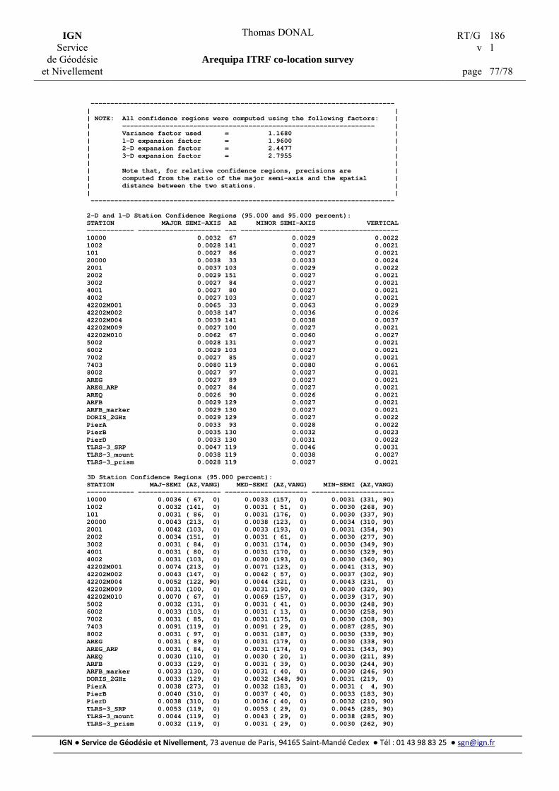
IGNService
de Géodésieet Nivellement
Thomas DONAL RT/Gv
page
1861
77/78Arequipa ITRF co-location survey
----------------------------------------------------------------------------- | || NOTE: All confidence regions were computed using the following factors: || ---------------------------------------------------------------- || Variance factor used = 1.1680 || 1-D expansion factor = 1.9600 || 2-D expansion factor = 2.4477 || 3-D expansion factor = 2.7955 || || Note that, for relative confidence regions, precisions are || computed from the ratio of the major semi-axis and the spatial || distance between the two stations. || | -----------------------------------------------------------------------------
2-D and 1-D Station Confidence Regions (95.000 and 95.000 percent):STATION MAJOR SEMI-AXIS AZ MINOR SEMI-AXIS VERTICAL------------ --------------------- --- ------------------- --------------------10000 0.0032 67 0.0029 0.00221002 0.0028 141 0.0027 0.0021101 0.0027 86 0.0027 0.002120000 0.0038 33 0.0033 0.00242001 0.0037 103 0.0029 0.00222002 0.0029 151 0.0027 0.00213002 0.0027 84 0.0027 0.00214001 0.0027 80 0.0027 0.00214002 0.0027 103 0.0027 0.002142202M001 0.0065 33 0.0063 0.002942202M002 0.0038 147 0.0036 0.002642202M004 0.0039 141 0.0038 0.003742202M009 0.0027 100 0.0027 0.002142202M010 0.0062 67 0.0060 0.00275002 0.0028 131 0.0027 0.00216002 0.0029 103 0.0027 0.00217002 0.0027 85 0.0027 0.00217403 0.0080 119 0.0080 0.00618002 0.0027 97 0.0027 0.0021AREG 0.0027 89 0.0027 0.0021AREG_ARP 0.0027 84 0.0027 0.0021AREQ 0.0026 90 0.0026 0.0021ARFB 0.0029 129 0.0027 0.0021ARFB_marker 0.0029 130 0.0027 0.0021DORIS_2GHz 0.0029 129 0.0027 0.0022PierA 0.0033 93 0.0028 0.0022PierB 0.0035 130 0.0032 0.0023PierD 0.0033 130 0.0031 0.0022TLRS-3_SRP 0.0047 119 0.0046 0.0031TLRS-3_mount 0.0038 119 0.0038 0.0027TLRS-3_prism 0.0028 119 0.0027 0.0021
3D Station Confidence Regions (95.000 percent):STATION MAJ-SEMI (AZ,VANG) MED-SEMI (AZ,VANG) MIN-SEMI (AZ,VANG)------------ --------------------- --------------------- ---------------------10000 0.0036 ( 67, 0) 0.0033 (157, 0) 0.0031 (331, 90)1002 0.0032 (141, 0) 0.0031 ( 51, 0) 0.0030 (268, 90)101 0.0031 ( 86, 0) 0.0031 (176, 0) 0.0030 (337, 90)20000 0.0043 (213, 0) 0.0038 (123, 0) 0.0034 (310, 90)2001 0.0042 (103, 0) 0.0033 (193, 0) 0.0031 (354, 90)2002 0.0034 (151, 0) 0.0031 ( 61, 0) 0.0030 (277, 90)3002 0.0031 ( 84, 0) 0.0031 (174, 0) 0.0030 (349, 90)4001 0.0031 ( 80, 0) 0.0031 (170, 0) 0.0030 (329, 90)4002 0.0031 (103, 0) 0.0030 (193, 0) 0.0030 (360, 90)42202M001 0.0074 (213, 0) 0.0071 (123, 0) 0.0041 (313, 90)42202M002 0.0043 (147, 0) 0.0042 ( 57, 0) 0.0037 (302, 90)42202M004 0.0052 (122, 90) 0.0044 (321, 0) 0.0043 (231, 0)42202M009 0.0031 (100, 0) 0.0031 (190, 0) 0.0030 (320, 90)42202M010 0.0070 ( 67, 0) 0.0069 (157, 0) 0.0039 (317, 90)5002 0.0032 (131, 0) 0.0031 ( 41, 0) 0.0030 (248, 90)6002 0.0033 (103, 0) 0.0031 ( 13, 0) 0.0030 (258, 90)7002 0.0031 ( 85, 0) 0.0031 (175, 0) 0.0030 (308, 90)7403 0.0091 (119, 0) 0.0091 ( 29, 0) 0.0087 (285, 90)8002 0.0031 ( 97, 0) 0.0031 (187, 0) 0.0030 (339, 90)AREG 0.0031 ( 89, 0) 0.0031 (179, 0) 0.0030 (338, 90)AREG_ARP 0.0031 ( 84, 0) 0.0031 (174, 0) 0.0031 (343, 90)AREQ 0.0030 (110, 0) 0.0030 ( 20, 1) 0.0030 (211, 89)ARFB 0.0033 (129, 0) 0.0031 ( 39, 0) 0.0030 (244, 90)ARFB_marker 0.0033 (130, 0) 0.0031 ( 40, 0) 0.0030 (246, 90)DORIS_2GHz 0.0033 (129, 0) 0.0032 (348, 90) 0.0031 (219, 0)PierA 0.0038 (273, 0) 0.0032 (183, 0) 0.0031 ( 4, 90)PierB 0.0040 (310, 0) 0.0037 ( 40, 0) 0.0033 (183, 90)PierD 0.0038 (310, 0) 0.0036 ( 40, 0) 0.0032 (210, 90)TLRS-3_SRP 0.0053 (119, 0) 0.0053 ( 29, 0) 0.0045 (285, 90)TLRS-3_mount 0.0044 (119, 0) 0.0043 ( 29, 0) 0.0038 (285, 90)TLRS-3_prism 0.0032 (119, 0) 0.0031 ( 29, 0) 0.0030 (262, 90)
IGN ● Service de Géodésie et Nivellement, 73 avenue de Paris, 94165 Saint‐Mandé Cedex ● Tél : 01 43 98 83 25 ● [email protected]
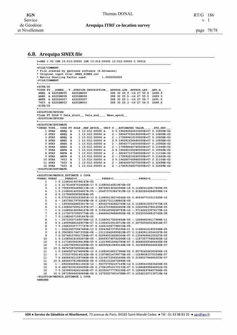
IGNService
de Géodésieet Nivellement
Thomas DONAL RT/Gv
page
1861
78/78Arequipa ITRF co-location survey
6.8. ArequipaSINEXfile%=SNX 1.00 IGN 15:013:00000 IGN 13:012:00000 13:012:00000 C 00012*-------------------------------------------------------------------------------+FILE/COMMENT* File created by geotosnx software (Z.Altamimi)* Original input file: AREG_SINEX.cov * Matrix Scalling Factor used: 1.0000000000-FILE/COMMENT*-------------------------------------------------------------------------------+SITE/ID*CODE PT __DOMES__ T _STATION DESCRIPTION__ APPROX_LON_ APPROX_LAT_ _APP_H_ AREQ A 42202M005 42202M005 288 30 25.9 -16 27 55.8 2488.9 AREG A 42202M008 42202M008 288 30 25.5 -16 27 55.5 2489.3 ARFB A 42202S007 42202S007 288 30 25.1 -16 27 56.7 2491.0 7403 A 42202M003 42202M003 288 30 25.3 -16 27 56.5 2488.8-SITE/ID*-------------------------------------------------------------------------------+SOLUTION/EPOCHS*Code PT SOLN T Data_start__ Data_end____ Mean_epoch__-SOLUTION/EPOCHS*-------------------------------------------------------------------------------+SOLUTION/ESTIMATE*INDEX TYPE__ CODE PT SOLN _REF_EPOCH__ UNIT S __ESTIMATED VALUE____ _STD_DEV___ 1 STAX AREQ A 1 13:012:00000 m 2 0.194282622510000E+07 0.10808E-02 2 STAY AREQ A 1 13:012:00000 m 2 -.580407034190000E+07 0.10808E-02 3 STAZ AREQ A 1 13:012:00000 m 2 -.179689419100000E+07 0.10808E-02 4 STAX AREG A 1 13:012:00000 m 2 0.194281636440000E+07 0.10858E-02 5 STAY AREG A 1 13:012:00000 m 2 -.580407714550000E+07 0.10992E-02 6 STAZ AREG A 1 13:012:00000 m 2 -.179688442740000E+07 0.11046E-02 7 STAX ARFB A 1 13:012:00000 m 2 0.194280335280000E+07 0.10946E-02 8 STAY ARFB A 1 13:012:00000 m 2 -.580407157560000E+07 0.11154E-02 9 STAZ ARFB A 1 13:012:00000 m 2 -.179692214240000E+07 0.11640E-02 10 STAX 7403 A 1 13:012:00000 m 2 0.194280760860000E+07 0.31104E-02 11 STAY 7403 A 1 13:012:00000 m 2 -.580406978370000E+07 0.32498E-02 12 STAZ 7403 A 1 13:012:00000 m 2 -.179691568370000E+07 0.32499E-02-SOLUTION/ESTIMATE*-------------------------------------------------------------------------------+SOLUTION/MATRIX_ESTIMATE L COVA*PARA1 PARA2 ____PARA2+0__________ ____PARA2+1__________ ____PARA2+2__________ 1 1 0.116804140794147E-05 2 1 0.317614087534460E-17 0.116804140819676E-05 3 1 0.750839554698113E-16 -.887466190363948E-18 0.116804140817600E-05 4 1 0.116804142554657E-05 -.204975703847419E-12 0.618228242840096E-14 4 4 0.117906959058384E-05 5 1 0.270183305183891E-13 0.116804138374542E-05 0.659367710311525E-12 5 4 -.183758179755569E-08 0.120817311188861E-05 6 1 -.199300428853617E-12 -.693527042822759E-12 0.116804150537073E-05 6 4 0.132856755913197E-07 -.621670394840600E-08 0.122009437861255E-05 7 1 0.116804162094127E-05 0.319614058258793E-12 -.571422233974173E-12 7 4 0.117307570925776E-05 -.446644394864905E-08 0.356353566812742E-08 7 7 0.119824571991847E-05 8 1 -.357230571690768E-12 0.116804170200644E-05 -.120866538117988E-11 8 4 0.149996861069079E-07 0.119243109100719E-05 0.507505065038914E-07 8 7 0.156632357777747E-07 0.124414367798010E-05 9 1 -.506234575967480E-13 0.100436673795330E-11 0.116804161855348E-05 9 4 0.356385174473352E-08 -.151118426995819E-07 0.118408116344187E-05 9 7 0.507481078517394E-07 0.529949106288304E-07 0.135494964155327E-05 10 1 0.116804181602874E-05 -.286593748722066E-12 -.118735775882925E-12 10 4 0.117345356094195E-05 0.112199018462780E-07 0.486800593684455E-08 10 7 0.118479459616499E-05 0.660594419493146E-08 0.323958900240632E-07 10 10 0.967470876550616E-05 11 1 0.246408742748969E-12 0.116804166537964E-05 0.807924264183456E-12 11 4 -.372357936145162E-08 0.118768314799776E-05 -.125983833753348E-07 11 7 0.646843611097486E-08 0.121547335655408E-05 0.218852784665253E-07 11 10 0.465663781982682E-08 0.105613124072894E-04 12 1 -.496384469211641E-12 -.963757052157149E-12 0.116804156634204E-05 12 4 0.486783351626992E-08 0.379619912170133E-07 0.118848599644001E-05 12 7 0.323960342415406E-07 0.223504777793106E-07 0.128482978457586E-05 12 10 0.287390466366696E-06 0.157552076014788E-07 0.105621257139719E-04-SOLUTION/MATRIX_ESTIMATE L COVA%ENDSNX
IGN ● Service de Géodésie et Nivellement, 73 avenue de Paris, 94165 Saint‐Mandé Cedex ● Tél : 01 43 98 83 25 ● [email protected]