Anarkik3D's '3D Consequences Project: 3D modelling & 3D printing

5-5-2012
Challenge the future
Delft University of Technology
3D Data Modelling in the
Netherlands
Dr Jantien Stoter TU Delft & Kadaster & Geonovum

2 3D data modelling
3D modelling in the Netherlands
1. 3D national standard for large scale topography
2. Adoption process of the national 3D standard
3. Implementation phase (work in progress)
4. Generation of a nation wide 3D topographic data set at mid
scale

3 3D data modelling
3D national standard: CityGML ADE for Information Model
Geography
Integration of:
1. CityGML:
• OGC standard for 3D geoinformation
• Semantics and geometry
2. 2D Information model large scale topography (IMGeo)
• object definitions for large scale representations of roads,
water, land use/land cover, bridges, tunnels etc
• data providers: municipalities, provinces, ProRail, RWS,
3D national standard Adoption process Implementation
Nation wide 3D data set

4 3D data modelling
IMGeo 2.0
• Formally established in February 2012
• 2D descriptions mandatory
• can be extended into 2.5D/3D according to principles of CityGML
• Reuse of valuable concepts and efforts (!) in the 2D domain
• 3D becomes in reach
OGC, 2008
3D national standard Adoption process Implementation
Nation wide 3D data set
2D

6 3D data modelling
2D+semantics
2.5D+semantics+topology
IMGeo
LOD0
LOD1 3D+semantics
LOD2
Extrusion upwards
Extrusion downwards
CityGML ADE for IMGeo
3D national standard Adoption process Implementation
Nation wide 3D data set

8 3D data modelling
Courtesy of Linda van den Brink
3D national standard Adoption process Implementation
Nation wide 3D data set

9 3D data modelling
3D national standard Adoption process Implementation
Nation wide 3D data set

10 3D data modelling
Why Align to 2D Information Model?
• Step from 2D to 3D makes 3D feasible
• Connecting to existing application provides justification for 3D
• Reuse of rich semantics available in 2D data sets
• Update process of 2D data can be used for 3D data
3D national standard Adoption process Implementation
Nation wide 3D data set

11 3D data modelling
Information model is available
For everyone
• As XSD
• UML models in Enterprise Architect format
http://www.geonovum.nl/nieuws/grootschalige-
geografie/informatiemodel-imgeo-20-en-xsd-als-download
OGC 3DSIG adopted our approach to model ADE of CityGML
3D national standard Adoption process Implementation
Nation wide 3D data set

12 3D data modelling
3D modelling in the Netherlands
1. 3D national standard for large scale topography
2. Adoption process of the national 3D standard 3. Implementation phase
4. Generation of a nation wide 3D topographic data set at mid
scale

13 3D data modelling
3D is practice in The Netherlands
Source: Prov NB
Source: RWS
Source: TNO
3D national standard Adoption process
Implementation Nation wide 3D data set

14 3D data modelling
But 3D is not mainstream:
• No generic 3D approach
• Project based
• Reinvest and restart for every new project
• For govermental organisations not clear what you can do with 3D
and how to do it
• 3D in NL is: ad hoc, redundant, not efficient + not all potentials are being used
3D national standard Adoption process
Implementation Nation wide 3D data set

15 3D data modelling
Adoption process of the 3D Standard
• Within 3D Pilot NL (March 2010 - June 2011)
• Initiated by: Kadaster, Geonovum, Ministery of Infrastructure
and Environment, Netherlands Geodetic commission
• Goals of 3D Pilot:
• Give directions to & push 3D in the Netherlands
• Collaborate with many stakeholders on use cases and test bed
• Share knowledge on 3D in a non- competitive setting
3D national standard Adoption process
Implementation Nation wide 3D data set

16 3D data modelling
3D Pilot Partners Phase I (68)
4Sight Gemeente Apeldoorn Moss (Germany) TNO ICT
Aerodata Gemeente Den Bosch Nedgraphics Topcon Sokkia
AGIV (Belgie) Gemeente Den Haag Neo TOPOSCOPIE
AHN Gemeente Groningen NLR Triformis
Alterra Gemeente Rotterdam Object Vision TU Delft c-graphics
Bentley Gemeente Tilburg Architect ONL TU Delft-GISt
BGT-LSV GBKN Geodan Oracle TU Delft-L&R
BLOM Netherlands Geodelta Oranjewoud TU Eindhoven
Cebra Geonovum Organic Vectory Universiteit Gent
Crotec Grontmij PBS Software L. (MapInfo) Universiteit Groningen
Curnet Hansa Luftbild Planbureau Leefomgeving Universiteit Utrecht
Cyclomedia Horus surround vision Politie KLPD WUR
Defensie iDelft Provincie NB Cobra Geoadviseurs
Esri NL Imagem (Erdas) RWS, DID TU Berlijn Eurosense Intergraph StrateGIS
Fugro ITC - U Twente Terra Imaging
Gemeente Leeuwarden IT-Pro People TNO Bouw en Ondergrond
Gemeente Amsterdam Kadaster TNO Defensie en Veiligheid
550 LinkedIn members; also active on Twitter
3D national standard Adoption process
Implementation Nation wide 3D data set
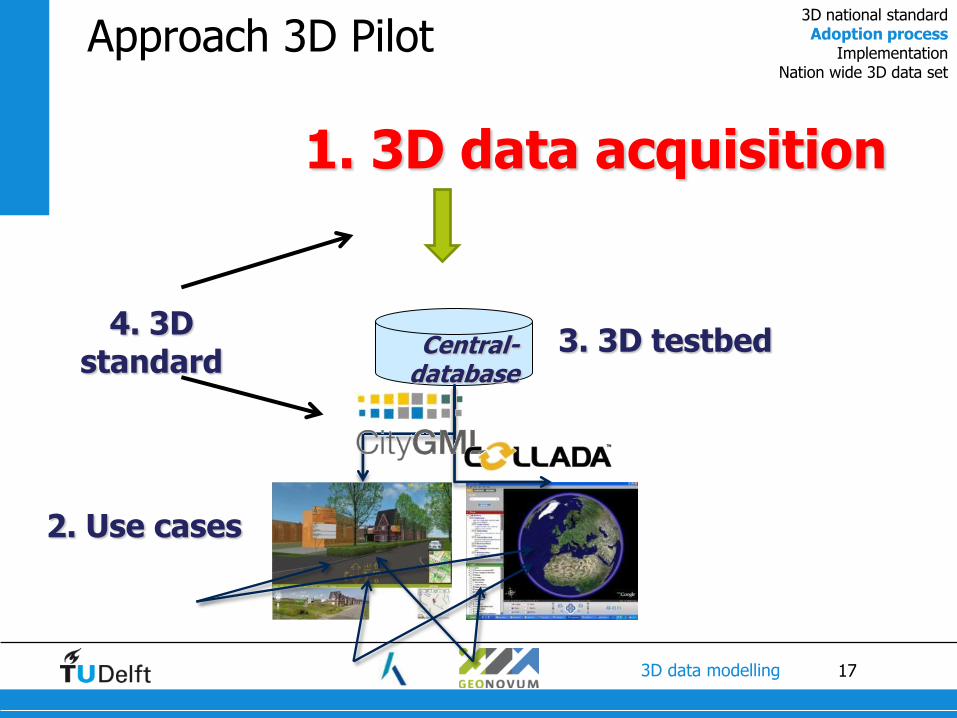
17 3D data modelling
Approach 3D Pilot
1. 3D data acquisition
Central-database
3. 3D testbed 4. 3D
standard
2. Use cases
3D national standard Adoption process
Implementation Nation wide 3D data set

18 3D data modelling
Approach 3D Pilot
3. 3D testbed 4. 3D
standard
2. Use cases
1. 3D data acquisition
Central-database
3D national standard Adoption process
Implementation Nation wide 3D data set

19 3D data modelling
Approach 3D Pilot
3. 3D testbed 4. 3D
standard
2. Use cases
1. 3D data acquisition
Central-database
3D national standard Adoption process
Implementation Nation wide 3D data set
20 3D data modelling
Approach 3D Pilot
1. 3D data
acquisition
3. 3D testbed 4. 3D
standard
2. Use cases
Central-database
3D national standard Adoption process
Implementation Nation wide 3D data set

21 3D data modelling
Test Data: “Kop van Zuid” area, Rotterdam AHN2 (Lidar)
GBKN
TOP10NL
Fugro (Lidar; for Rotterdam)
DTB, RWS
Topcon Sokkia
Imagem
TNO
GBKN
Cyclomedia Mobile laserscanning
Horus Surround Vision

22 3D data modelling
Comparison of 3D standards and
establishment of national 3D standard

23 3D data modelling
Data Further Processed to CityGML Data
U Twente
Bentley
IT-Pro people
Kadaster
Toposcopie
Bentley
Toposcopie
iDelft
Bentley
Gemeente
Rotterdam
Bentley
U Twente
3D national standard Adoption process
Implementation Nation wide 3D data set

24 3D data modelling
…. 3D data applied to use cases
Mutation detection 3D Kadaster
Geological
subsurface
Point Cloud viewer
Trees Airstream simulation
3D city model
3D Spatial Plans

25 3D data modelling
• Use cases available at YouTube:
http://www.geonovum.nl/dossiers/3dpilot/congres/english#3D_use_cases
3D national standard Adoption process
Implementation Nation wide 3D data set

26 3D data modelling
3D modelling in the Netherlands
1. 3D national standard for large scale topography
2. Adoption process of the national 3D standard
3. Implementation phase 4. Generation of a nation wide 3D topographic data set at mid
scale

27 3D data modelling
Next National 3D Steps
• We have a 3D standard; but are not there yet
• Follow-up pilot has started (Sept 2011- Sept 2012)
• Goals:
• Gain experience in working with the 3D standard
• Make further agreements in community driven setting
• Develop starterskit for new people
3D national standard Adoption process
Implementation Nation wide 3D data set

28 3D data modelling
New call for participation:100 organizations
200 persons; 550 LinkedIn members
3DSite IT&C BV Fugro Coenradie provincie noord-brabant
4Sight BV Gemeente Apeldoorn GW Rotterdam Reality Bytes
Oranjewoud gemeente Den Haag Intergraph Benelux B.V. rijksuniversiteit groningen
Alliander NV Gemeente Dordrecht ITC UTwente Rijkswaterstaat
Alterra Wageningen UR Gemeente Eindhoven Jupiter Light StrateGis Groep BV
AND Gemeente Gent, Belgie Kadaster Syntax InfraMediairs
Autodesk Gem. Leeuwarden Kaho Sint-Lieven, KU Leuven Technische Universiteit Delft
Ballast Nedam Engineering Gemeente Rotterdam KPG Nederland BV Technische Universiteit Eindhoven
Bentley Gem Den Bosch LENSEN geomanagement Teken-Projekt en Adviesburo"De Pol"
Witteveen+Bos Gemeente Tilburg NLR Terra Imaging
Blom Netherlands Gem.w. Rotterdam NedGraphics TNO / BIMserver.org
Breijn Geodan NEO BV TNO Geomodelling
Cobra geoadviseurs bv Geodelta Oadis Open BIM consultants TNO Technical Sciences
Crotec GeoID bvba Oracle Topcon Europe Positioning B.V.
CURNET Geonovum Oranjewoud B.V. Toposcopie
CycloMedia Technology B.V. Grontmij Nederland ORBIT GeoSpatial Technologies TU Delft
DelftTech BV Organic Vectory BV TU Eindhoven
Defensie xkpinfra Spacemetric BV Waterschap Noorderzijlvets
E-Semble Havenbedrijf Pitney Bowes Business Insight Vicrea
Esri Nederland iDelft BV U Twente en NCG VU A'dam -SPINLAB
Fast-Fox Imagem Planb. Leefomgeving (PBL) Universiteit Utrecht

30 3D data modelling
Phase II 3D Pilot
6 work packages
3D national standard Adoption process
Implementation Nation wide 3D data set

31 3D data modelling
Work package 1
• Collecting input 3D data and creating example 3D IMGeo data
• compliant to 3D standard
• several levels of detail
• several themes (buildings, bridge, trees)
LOD0 and LOD2 2D LOD
Buildings (Oude Elberink, 2010)
Trees (iDelft) Trees (Alterra)
Bridge, Coenradie
LOD1
LOD2
LOD3
Trees (Alterra)

32 3D data modelling
Work package 2
• Defining example specifications for tendering documents for building 3D datasets
CityGML Den haag != CityGML Rotterdam
3D national standard Adoption process
Implementation Nation wide 3D data set

33 3D data modelling
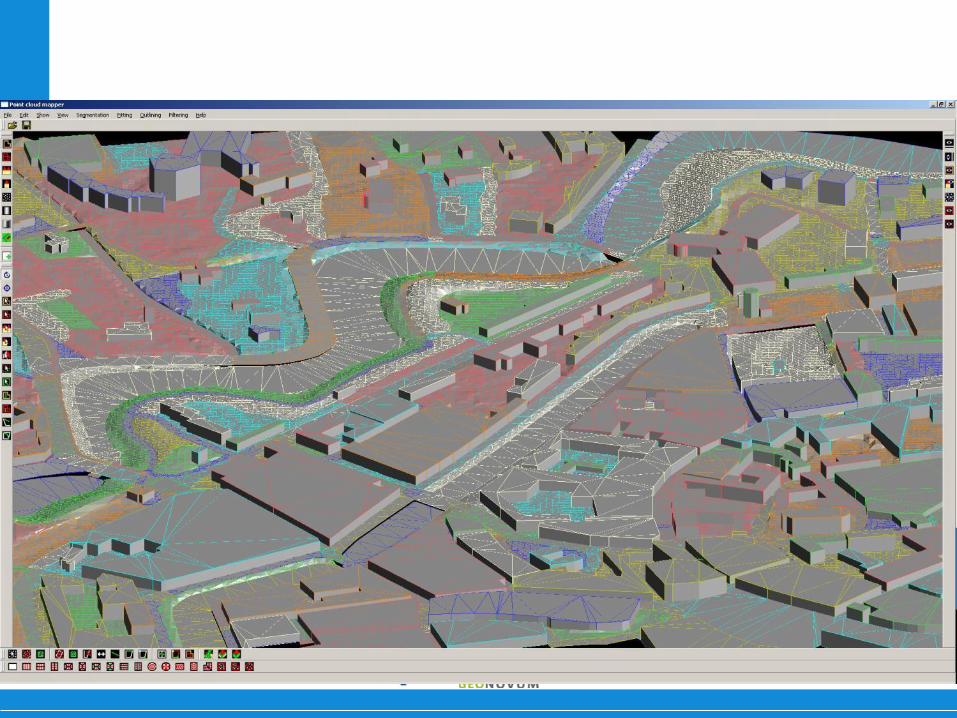
Work Package 3
• Design and implemention of 3D Validator
3. Get result
2. Validate
1.Upload IMGeo-GML file
Success Success
Success Source: 3D Pilot – 3D Validation Team
3D national standard Adoption process
Implementation Nation wide 3D data set

34 3D data modelling
• Generic approach for maintenance, update and dissemination of 3D data
• CityGML relay planned
Work package 4
3D national standard Adoption process
Implementation Nation wide 3D data set

35 3D data modelling
Collecting 3D killer applications www.3dpilot.nl
Work package 5

36 3D data modelling
Work package 6
• Aligning CityGML and BIM standard (IFC) • Prepare IFC models for use in GIS
• Make agreements on formal mappings, so that every
conversion is done in the same meaningful way
3D national standard Adoption process
Implementation Nation wide 3D data set

37 3D data modelling
3D modelling in the Netherlands
1. 3D national standard for large scale topography
2. Adoption process of the national 3D standard
3. Implementation phase
4. Generation of a nation wide 3D topographic data set at mid scale

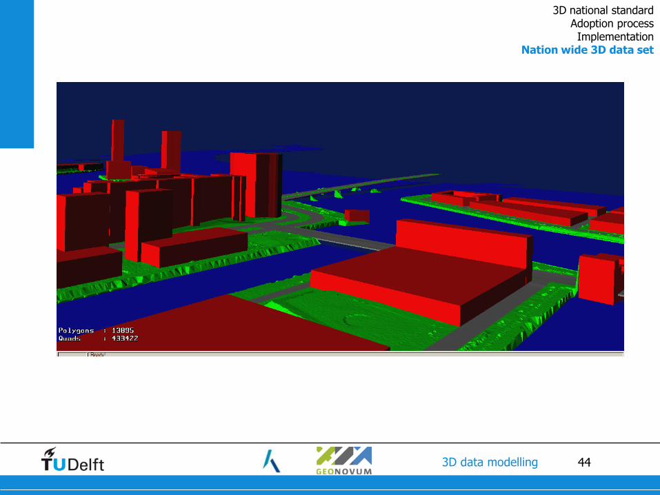
38 3D data modelling
Nation wide 3D topographic data set
• Mid scale (1:10k): easier to generate
• One data provider (Kadaster)
• Smart combination of TOP10NL and AHN2
• Based on (Oude Elberink & Vosselman 2010)
AHN2 TOP10NL

43 3D data modelling
Water is plane
Road is continuous
Terrain has varying heights
Terrain connects to water
Building as block
First results 3D TOP10NL
Oude Elberink, ITC, U Twente
3D national standard Adoption process Implementation
Nation wide 3D data set
44 3D data modelling
3D national standard Adoption process Implementation
Nation wide 3D data set

49 3D data modelling
Quality
• Low values due to time differences between source data sets
3D national standard Adoption process Implementation
Nation wide 3D data set

50 3D data modelling

51 3D data modelling
Beyond visualisation

52 3D data modelling

53 3D data modelling
54 3D data modelling

55 3D data modelling
• 3D applications are indispensable for managing and planning our
densily built-up environment
• Gained insights in the Netherlands:
• “3D is nice, but I do not know how” to “focused 3D ambitions”
• Agreements and collaboration are essential to move forward in the
highly complex domain of 3D information
Source: Prov NB Conclusions (1/2)

56 3D data modelling
• Crucial for the adoption of the standard:
• Support by many, many stakeholders
• Aligning to 2D efforts and to international standard (CityGML)
• Collaboration
• National governmental organizations take responsibility:
• Facilitate collaboration
• Maintenance of standards (by Geonovum)
• Providing a midscale 3D base data set with national coverage (by Kadaster)
Conclusions (2/2)

57 3D data modelling
More information 3D Pilot:
www.geonovum.nl/dossiers/3d-pilot
#3dpilot
Linkedin group 3D Pilot NL
Source: Prov NB
Source: RWS
Source Oude Elberink, 2010
Source: TNO
I
Email: