· Web viewThe port is now the shore base for the maintenance of the Rampion offshore wind farm...
122
A Profile of Newhaven Newhaven Town Council June 2018 1
Transcript of · Web viewThe port is now the shore base for the maintenance of the Rampion offshore wind farm...

A Profile of
Newhaven
Newhaven Town Council
June 2018
1

Contents
Topic Page number
Introduction 3
Brief History of Newhaven 4
An Overview of Present Day Newhaven 4
Social ProfilePopulationHouseholdsHealthEducationGreen InfrastructureTransportCyclingServices
5
Economic ProfileEmploymentEconomic TrendsRetailTourismThe Port
17
Environmental ProfileCharacteristicsDesignationsConservation AreasAllotmentsCoastlineWaterFlooding
23
Appendix 1 – A review of evidence-based documents 39
2

Introduction
This ‘Profile’ of Newhaven has been put together to provide a wide range of background information on the town which provides essential context for producing the Newhaven Neighbourhood Plan. Comments have been invited on this document in the consultation process so that the community can input into the background information on the town, which may in turn highlight what needs to be a focus for the Neighbourhood Plan.
The ‘Profile’ will be a living document in that it will be updated as new evidence comes to light. The first ‘Profile’ was produced in 2014 and much of the evidence used came from the 2011 census and remains the primary data source. Where there are updates or refreshed predictions these will be noted in the updated document.
Specifically, the ‘Profile’:
Provides evidence and a starting point in understanding what makes Newhaven ‘tick’ and what issues impact on the different communities within the town area.
Helps establish the scope of the Strategic Environmental Assessment (hereafter referred to as the ‘Sustainability Appraisal’), by which the draft and final versions of the Newhaven Neighbourhood Plan will be assessed and refined and, in doing so, provide the Town Council with a means of consulting the statutory authorities on its proposed scope.
Provides a listing of evidence-based documents which relate to Newhaven at Appendix 1
In assessing where Newhaven is today, it is useful to consider how the town has evolved and what has contributed to its present-day character. The following brief history sets out how this unique and distinctive town has derived its ‘sense of place’.
There have been people living in the Newhaven area for many thousands of years. Relics found on Castle Hill, a prominent site on the cliff tops, include Stone Age struck flints, Neolithic pottery, bronze and Iron Age items. Fortifications were probably first built on Castle Hill in around 400BC and it is thought that there was a Roman Villa here too.
The Saxons later founded a village called Meeching on the banks of the River Ouse and the name Meeching comes from the Saxon word “meces” and means people or the camp of the sword. St Michaels Church on the west side of the town was built by the Normans in 1120.
During Medieval times the mouth of the river was located to the east at Seaford, but after a significant storm in 1579 this area became blocked and the river breached at shingle area further west between Meeching and Seaford.
3
Brief History of Newhaven

This caused flooding and so the south section of the river was straightened, so with a new cutting a fixed harbour entrance became established, which was known as New Haven. The name Meeching gradually fell into disuse, (although it is still preserved in street names and is the name of the local school).
Newhaven became one of only two fully navigable harbours between Portsmouth and Dover and was used for trade, as well as supporting a ship building industry. After 1784 a wooden bridge was built across the river which survived till 1866 and was not replaced with an iron swing bridge until 1974 (after which the present day electrically opened bridge was built).
In the year 1800 HMS Brazen, an 18 gun sloop of war was wrecked beneath the cliffs of Newhaven. All but 1 of the 106 men on board died and their bodies were washed up on Newhaven’s beaches. This inspired a local committee to look into the provision of a lifeboat at Newhaven and in 1803 a lifeboat of William Greathead’s ‘original’ design was provided, more than 20 before the formation of the Royal National Lifeboat Institution (RNLI) in 1824. The Newhaven Lifeboat Station celebrated the 200th anniversary of the station in 2003.
Map 1 – The location of Newhaven within the Lewes District area and the Newhaven Parish Area
4

Overview of Present Day Newhaven
Newhaven has a strong sense of identity which is visually enhanced by the background of the South Downs and the adjacent River Ouse and the coast. Today the people of Newhaven remain proud of the maritime Heritage of their town and the continuing status of the town as a port with its daily ferry to Dieppe.
The town remains an important gateway to Europe and is in a key strategic location, placed within short distances of the large town of Eastbourne, the City of Brighton and the County town of Lewes.
It is a medium sized town with a population of just under 13,000 and has a range of characteristics that in parts are urban, rural and coastal. The town’s industrial image and history are set against a backdrop of an outstanding landscape of rolling hills. The town has a strong history in fishing, manufacturing and port activities.
In recent years the town has experienced some regeneration, but like other areas has been the victim of the economic downturn, with investment reducing and previous industries falling out of favour. Consequently, many local people seek work out of Newhaven. It is recognised that Newhaven continues to need considerable investment, and regeneration of the town remains a priority at regional and local government level.
These issues along with the reduction in public spending and private investment have put a strain on the town and in certain areas, such as the town centre, this is particularly evident.
Despite these challenges, there is a strong sense of place and community in the town. This is for good reason. As well as the appreciation of the unique setting of the town as it lies adjacent to the sea and nestling in a gap of the South Downs National Park, there are many potential opportunities for the town to thrive and prosper.
Social Profile
The following statistics and evidence are primarily drawn from the 2011 Census though some updates to data sets have been made and have noted in this document.
Other sources of data or information are acknowledged where applicable. In some instances, other areas have been included for comparison and earlier statistics have been utilised so that trends can be identified.
Population
With the strong community and a sense of pride in the town there are over 150 active community groups and a successful community development association within the town.
Population by age groups in 2011
5
Age All people
Percent aged 0-14
Percent aged 15-29
Percent aged 30-44
Percent aged 45-64
Percent aged 65+GeographyEast Sussex 526,671 16.1 15.9 17.2 28.0 22.7Lewes 97,502 16.2 15.2 17.3 28.5 22.7Newhaven 12,232 18.3 18.2 19.7 26.6 17.2
Source: 2011 Census, Office for National Statistics
Population by marital and civil partnership status in 2011This dataset shows the number of people aged 16 and over and the percentage by marital status from 2011 Census.
Marital status
All people aged 16
and over
Percent
single
Percent married
Percent in a registered
same-sex civil partnership
Percent separate
d
Percent divorced
Percent widowed
Geography
East Sussex 435,515 29.1 48.4 0.3 2.7 10.7 8.7
Lewes 80,534 28.7 49.6 0.5 2.5 10.2 8.4Newhaven 9,851 33.1 44.6 0.4 3.5 12.0 6.4
Source: 2011 Census, Office for National Statistics
Children living in poverty (2011 and 2016)
In 2011 21.6% Newhaven Denton and Meeching, 22.5% Newhaven Valley (Lewes 14.8%)
In 2016 21.6% Newhaven Denton and Meeching, 25.1% Newhaven Valley (Lewes 13.4%)
Households
Household composition in 2011This dataset shows the total number of households and percentage by household type from 2011 Census. A household is defined as one person living alone, or a group of people (not necessarily related) living at the same address who share cooking facilities and share a living room, sitting room or dining area. Household composition here classifies households according to the relationships between householders.
Household sub-type
Allhouseholds
Percent one person
households
Percent all family households
Percent other households
GeographyEast Sussex 231,905 32.8 61.2 6.1Lewes 42,181 30.2 63.6 6.2
6

Newhaven 5,252 29.9 62.5 7.6Source: 2011 Census, Office for National Statistics
Households in poverty in 2013This dataset shows the number and percentage of households living in poverty. A household in poverty is one whose income is below 60% of the GB median household income, which in 2013 was £16,814.
Measure Median household income (£)
Total number of households
Number of households below 60% of GB median
Percentage of households below 60% of GB median
Geography
East Sussex 27,198 236,516 65,181 27.6Lewes 28,469 43,492 11,357 26.1Newhaven 25,962 5,369 1,532 28.5
Households in fuel poverty % (2016) super output areas
Newhaven Valley (9.7%) Newhaven Denton and Meeching (9.8%) (Lewes 8.8%)
Information Sources: East Sussex in Figures
Average Household Income Parish (2013)
Newhaven £33,149 (East Sussex £34.945)
Households in Newhaven on the District Councils Housing Register 2017
LDC Housing Register – Whole District
1 bed 2 bed 3 bed 4 bed 5 bed Total
At 31 August 2017 449 293 157 42 4 945
LDC Housing Register: Newhaven
1 bed 2 bed 3 bed 4 bed 5 bed Total
At 31 August 2017 58 47 27 2 1 135
Information Sources: Lewes District Council Housing Need August 2017
Average household income in 2013This dataset gives modelled estimates of mean and median average household income. Household income includes gross income before tax from: wages, investments, income support and other
7

welfare benefits such as tax credits and pensions. Household income is the combined income of all household members.
Average Mean income
Median incomeGeographySouth East 40,249 31,850East Sussex 34,945 27,198Lewes 36,585 28,469Newhaven 33,149 25,962
Information Sources: East Sussex in Figures
After 2015 Indices of deprivation at Parish Level were no longer available.
Housing Stock by Type in Newhaven (2001 Census)
Flats 6.9% (East Sussex 9.3%)Purpose built flats 11.9% (East Sussex 13.9%)Terraced Housing 30.1% (East Sussex 18.6%)Semi-detached 29.7% (East Sussex 24.8%)Detached 20.1% (East Sussex 33.5%)
Health
Limiting long-term illness in 2011This dataset shows the percentage of people that have a limiting long-term illness or disability from 2011 Census.
Type All people
Percent people with long-term health problem
or disability
Percent day-to-day activities limited a
lot
Percent day-to-day
activities limited a little
Percent people without
a long-term health problem or disabiltyGeography
East Sussex 526,671 20.3 9.2 11.2 79.7
Lewes 97,502 19.5 8.7 10.9 80.5Newhaven 12,232 18.9 8.5 10.4 81.1
Primary Care
8

The Lewes District Council Infrastructure Delivery Plan states that there are pockets of poorer health in Newhaven, and life expectancy is 5.2 years lower for men in the most deprived areas of the district compared with the least deprived areas. It is anticipated that Quayside Surgery could be extended to accommodate additional services. Information source: Lewes District Council Infrastructure Delivery Plan 2014
Education
Education facilities
South Downs College, Denton IslandSeahaven Academy, South Down Road (11 – 16years)University Technical College (14 – 19 years) Opened September 2015Denton Community Primary School, Acacia RoadHarbour Primary School, Church HillMeeching Valley Primary School (renamed Breakwater Academy), Valley RoadHighcliff Acedemy, South Down Road
Qualifications in 2011This dataset shows the percentage of all people aged 16 and over by highest level of qualification held from the 2011 Census.
Qualifications
All usual residents aged
16 and over
No qualifi
c-ations
Highest level of qualification:
Level 1
Highest level of
qualification:
Level 2
Highest level of
qualification: Apprenticesh
ip
Highest level of
qualification: Level 3
Highest level of qualifica
tion: Level 4
and above
Geography
East Sussex 100.0 22.6 14.1 16.8 3.5 12.0 26.2
Lewes 100.0 21.5 13.8 15.7 3.4 11.8 29.4Newhaven 100.0 25.6 18.5 16.7 3.5 12.4 18.6
Five or more GCSE passes at A* – C (2011/2012)
In 2011/12 Seahaven Academy (previously Tideway School) had a 37.9% pass rate for Grades A* to C, the lowest of all the secondary schools in the Lewes District. This falls below the East Sussex average figure of 57.5%.
In 2017: Maths and Science performance at 4+ was broadly in line with national averages. Geography performance at 4+, 5+ and 7+ was in line with or above national averages.
9

GCSE PE performance at 4+ was above national averages. Students achieved grade 9 in a number of subjects including English, Math, Science, Geography, History, French and Religious Studies.
Information Source: East Sussex in Figures
Early years and childcare
It is likely that further contributions from new housing development will be required if the gap increases between government funding and the actual cost of providing necessary Early Years provision in the right location. Future education infrastructure requirements will be subject to review as new information on pupil/child number forecasts becomes available.
Primary Schools
ESCC has advised that any shortfall in primary school provision in Newhaven, over the Core Strategy period will be accommodated through the expansion of existing primary schools.
Secondary Schools
ESCC has advised that there will be shortfalls in secondary school provision in Newhaven over the Core Strategy period. These shortfalls will be accommodated through the expansion of existing schools.
Library
A new Library was provided in Newhaven High Street in March 2015.
Green Infrastructure
Green infrastructure comprises of a range of open spaces such as formal and informal recreation areas, green corridors, parks and gardens, allotments, accessible countryside in urban fringe areas and cemeteries.
Formal recreational facilities:
Fort Road recreation GroundLewes Road recreation GroundDenton recreation GroundEastSide recreation GroundMeeching Valley recreation Ground
Lewes District Council Outdoor Playspace Review 2004 identified:
there is an overall undersupply (3.1acres) in the total number of football pitches in Newhaven
there are no hockey or rugby clubs based within the town as there are no facilities and
10

therefore no hockey or rugby pitch surpluses or shortfalls have yet been identified. Newhaven Hockey Club is currently based in Seaford and would like to relocate back to their home town.
there is a small number of football clubs with Newhaven based players who travel to home grounds in other parts of district in order to have access to pitches.
there is a small under-supply of 1.5 cricket pitches.
Informal Recreational Space
Older parts of the town have little civic or amenity greenspace, which indicates the need for pocket parks and improved linkages where possible.
Every opportunity should be explored and taken to enhance the river spaces and the beach to provide high quality and characterful recreational spaces.
Newhaven’s setting enables local people in the north, west and southern parts to have access to the surrounding countryside; downland, sea cliffs, river landscapes and seaside.
People in the Town Centre lack access to areas of high quality civic space.
There is no area of parkland with high quality gardens, but areas such as West Quay offer a high quality amenity area of a maritime character.
The river, while providing wonderful character, acts as a severing agent, cutting the town in half, thus reducing linkages across. The ring-road in the centre has a similar effect.
Demand for Green infrastructure
The following views were gathered in a District Council survey in 2005:
Newhaven people are of the opinion that there is insufficient informal recreation for children and young people, with not enough for them to do, and too much vandalism, graffiti and litter.
They would like more semi-natural urban greenspace, Home Zones in Newhaven West Area, more trees along roadsides and better maintenance.
Some people feel there is too little amenity greenspace and too few allotments.
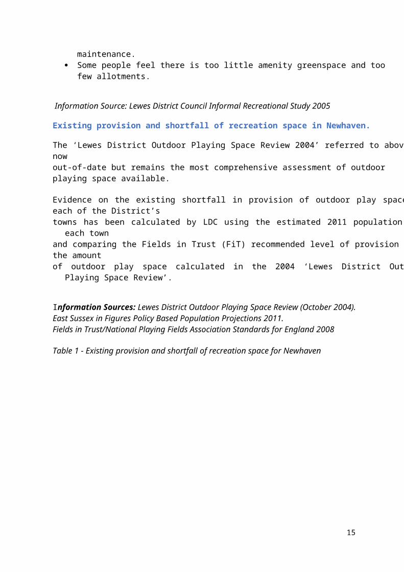
Information Source: Lewes District Council Informal Recreational Study 2005
Existing provision and shortfall of recreation space in Newhaven.
The ‘Lewes District Outdoor Playing Space Review 2004’ referred to above is now out-of-date but remains the most comprehensive assessment of outdoor
11

playing space available.
Evidence on the existing shortfall in provision of outdoor play space in each of the District’s towns has been calculated by LDC using the estimated 2011 population for each town and comparing the Fields in Trust (FiT) recommended level of provision with the amount of outdoor play space calculated in the 2004 ‘Lewes District Outdoor Playing Space Review’.
Information Sources: Lewes District Outdoor Playing Space Review (October 2004).East Sussex in Figures Policy Based Population Projections 2011.Fields in Trust/National Playing Fields Association Standards for England 2008
Table 1 - Existing provision and shortfall of recreation space for Newhaven
Allotments
47 allotment plots at land off Lewes Road, with 40 people on the waiting list as at May 2018.
Cemetery
Newhaven Cemetery is owned and managed by the Town Council. There remains good capacity for the foreseeable future.
Transport
The town is connected to Brighton by the A259, a heavily congested urban road and to the trunk road
12
Existing
Provision (ha)
FiT recommended level of provision
(ha) Shortfall (ha)
Amount provided as %
of FiT recommendatio
n
Popu
lati
on Out
door
sp
orts
Info
rmal
ch
ildre
n'Eq
uipp
ed O
utdo
or
spor
ts
Info
rmal
ch
ildre
n'
Equi
ppe
d Out
door
sp
orts
Info
rmal
ch
ildre
n'Eq
uipp
ed O
utdo
or
spor
tsIn
form
al
child
ren'
Equi
ppe
d
Lewes16348
21.45 2.91 0.73
26.16 8.99 4.09
4.71 6.08 3.36
82% 32% 18%
Seaford24022
9.74 5.92 0.83
38.47
13.22 6.01
28.73 7.3 5.18
25% 45% 14%
Newhaven
12225
5.54 2.95 0.27
19.56 6.72 3.06
14.02 3.77 2.79
28% 44% 9%
Peacehaven & Telscombe
21657
5.81
10.56 1.36
34.65
11.91 5.41
28.84 1.35 4.05
16% 89% 25%

network by the A26. This joins the A27 at Beddingham. The River Ouse is crossed by a single bridge and the occasional need for it to ‘swing open’ results in congestion and delays on the A259 a major east/west route.
Newhaven is also connected to the rail network by a branch line to Lewes and has a direct and frequent service to Brighton.
As well as good land-based connections, Newhaven has a daily ferry service to Dieppe.
Map 2 showing east/west running A259, A26 running north and the towns’ stations.
Car ownership – This chart shows the percentage of households by number of cars or vans owned or available for use by that household.
13

Number of cars in 2011
This dataset shows the number of cars or vans, including any company car or van if available for private use, the number of households in the area and the number of cars/vans per household. Also shown is the percentage increase in households, cars and vans, and the number of cars/vans per household since 2001.
Measure All cars or vans in the area
All households
Number of vehicles per householdGeography
East Sussex 292,118 231,905 1.3Lewes 53,124 42,181 1.3Newhaven 5,853 5,252 1.1
Method of travel to work in 2011This dataset shows which modes of transport are used by those who are in employment to get to their place of work, by broad transport type. The information in this table has been produced using only people's response to method of travel to work questions in the 2011 Census this data is not comparable with 2001.
Mode of travel to work
All people
aged 16-74 in
Percentage of people
who work at or mainly
Percentage of people who use
public
Percentage of
people who use
Percentage of people
who
Percentage of people who use another
modeGeography
14
employme from home transport a private walk or of transportEast Sussex 239,319 7.9 11.4 66.8 13.3 0.6Lewes 45,532 8.0 16.0 62.6 12.8 0.6Newhaven 5,899 3.8 14.4 65.6 15.7 0.5
Information Sources: 2011 Census, Office for National Statistics
Trains
The town has two railway stations offering direct train services to London, Lewes, Seaford and Brighton.
Buses
There is a regular bus service from Newhaven to Brighton, Seaford and Eastbourne (Brighton and Hove Bus Company) and a more infrequent service to Lewes (Rider Bus)
Cycling
National Cycle route 2 (part of the London to Paris cycle way) goes through Newhaven and provides a cycle path to Seaford and beyond.
Brighton to Newhaven Coast Loop cycle route (19.5 miles)
Brighton to Eastbourne Cycle route (34 miles)
A cycle route (Egrets Way) linking Newhaven to Lewes is partially complete with sections yet to be identified and provided. Some £1.5 Million of funding is required to complete the project.
In November 2013 a public consultation exercise was undertaken by East Sussex County Council to seek people’s views about proposed pedestrian, cycling and bus improvements in Newhaven and Peacehaven. The following results were obtained:
75% of respondents supported or strongly supported the proposal for a cycle/pedestrian facility from the A259 Brighton Road in Peacehaven to Newhaven Town Centre;
45% of respondents preferred using the route that ran through Upper Valley Road, Northdown Road, First Avenue and Second Avenue while 55% preferred using the A259 then Polyclinic access road to the south to go to and from Newhaven town centre;
50% of respondents supported or strongly supported the use of the High Street and St Luke's Lane, Newhaven by cyclists;
66% of respondents supported or strongly supported the provision of additional cycling and pedestrian facilities in the Denton area of Newhaven.
15

Local Highway and accessibility improvements
ESCC have identified that in Newhaven the planned development needs to be supported by a range of transport measures to mitigate congestion and increase highway capacity, including:
Junction improvements on the Newhaven town centre ring road Improvements to the A259/A26 junction in Newhaven Demand management measures on the A259 corridor, focussed on maximising bus use Improvements to bus infrastructure and the walking and cycling network
A Newhaven Transport Study produced in 2011 by East Sussex County Council carried out forecasting for a peak AM peak hour and PM peak hour. The study looked at the impacts of a number of development scenarios on the traffic in Newhaven.
The draft report on the “Physical Development Vision for Newhaven Stage 2” produced by BBP Regeneration in April 2010 considered the potential for a new western link between the Meeching Quarry development site and the A259 for local access and public transport only.
Assessments showed that the proposed link would reduce the traffic delays on the ring road and improve overall connectivity to and from the western part of Newhaven. However, it was stated that the costs of providing the links would be significant and be dependent on the potential funding from private developers in the area.
Phase 2 of the Port Access Road providing a new road to the Port has not yet commenced as at June 2018, although work is expected to commence in early 2019.
Services
Fire and Rescue
Newhaven Community Fire Station relocated to shared space in Meeching Road in 2016 in order to improve cover in the Peacehaven/Telscombe area by improving response times.
Police
In 2016 Newhaven Police station moved from South Road to Meeching Road to new shared space with the Fire Service.
Ambulance
There are two ambulance stations in the Lewes District located in the towns of Lewes and Newhaven.
The Trust are considering moving to a Depot based model of service delivery, which would mean moving away from traditional ambulance stations to a matrix of response and standby posts. The Depot would be home to a number of ambulance teams, a response post would have crew facilities,
16

and a standby post would be a location from which crews respond at predictable periods of peak activity. How this may impact on Newhaven is being investigated.
Information source: Lewes District Council Infrastructure Delivery Plan 2014
Key Issues and Comments relating to the Social profile
By virtue of its employment base and location on important public transport routes, Newhaven is seen by the District Council as the most sustainable location for housing development and therefore the town will see a significant rise in population.
Need to balance housing needs identified in Lewes District Core Strategy with protection of urban, rural and coastal environments.
Current housing stock shows relatively low number of flats whilst relatively high number of single households. Newhaven has a relatively high proportion of young people under the age of 29. These are people that will be looking for smaller type of accommodation in the future.
Current higher evidence of single person households need through LDC Housing needs survey.
Relatively low choice of detached homes in the existing housing stock and therefore smaller choice of homes to aspire to.
Pockets of poorer health which may generate the need for homes suitable for adaptation
Higher long term sickness Increasing % of children in poverty Lower percentage of people work from home compared with other local areas Higher incidence of people walking and cycling to work suggests local employment
opportunities Predicted shortfall in early years, primary school and secondary school provision Relatively poorer educational achievement Undersupply of formal recreation provision and play space continues Older parts of the town have little public amenity space Natural and man-made elements sever parts of the town from one another A259 which is a heavily congested urban road and to the trunk road network by
the A26.
Economic Profile
17

This profile provides key characteristics of the local economy.
Economic activity and inactivity in 2011(%)
This dataset shows economic activity and inactivity amongst those aged 16-74 from the 2011 Census.
category
All p
eopl
e ag
ed
16-7
4Al
l eco
nom
ical
ly
activ
e
Empl
oyee
Self-
empl
oyed
Une
mpl
oyed
Econ
omic
ally
ac
tive
full-
time
All e
cono
mic
ally
in
activ
eLo
ng-t
erm
sick
or
Look
ing
after
ho
me
Retir
ed
Economically inactive student (including full-time)
Oth
er in
activ
e
Geography
East Sussex 100.0 68.1 48.
213.
43.6 2.8 31.
94.1 4.2 17.
8 4.0 1.8
Lewes 100.0 69.6 49.
713.
93.3 2.7 30.
43.5 3.9 17.
6 3.7 1.8
Newhaven 100.0 71.3 54.
3 9.5 4.5 3.0 28 5.
1 4.0 14 3.0 1.7
Employment by industry in 2011
This dataset shows the percentage of people in employment in Newhaven aged 16-74 by industry with comparison to East Sussex from the 2011 Census.
Agriculture, miming and utilities - 2.7% (East Sussex 2.1%% ) Manufacturing - 8.7% (East Sussex 6.1% ) Construction – 9.3% (East Sussex 9.4% ) Wholesale, retail, trade, repair of motors - 17% (East Sussex 16% ) Transport and storage - 7.1% (East Sussex 4.1% ) Accommodation, food services – 5.2% (East Sussex 5.6% ) Information and communication - 2.1% (East Sussex 2.9% ) Financial, insurance and real estate – 5.1% (East Sussex 5.9% ) Professional, scientific and technical activities – 3.7% (East Sussex 6.2% ) Administrative and support services - 5.1% (East Sussex 4.5%) Public administration and defence, compulsory social security – 6.3% (East Sussex
5.5%) Education – 8.7% (East Sussex10.3% ) Human Health and social work – 14.4% (East Sussex 15.6% ) Other – 4.7% (East Sussex 5.7%)
Unemployment in 2011(%)
18

Newhaven has been badly affected by the recession and generational deprivation is entrenched in some parts of the community, with more than one in eight (13%) of adult residents claiming out of work benefits.
This dataset shows the number and percentage of the economically active population, aged 16-74 who were unemployed, by gender, age groups and whether or not they have ever worked and length of unemployment from the 2011 Census.
Unemployment category
All usual
residents aged 16 to
74
Percent aged 16-74
Percent aged 16-24
Percent
aged 50-74
long-term unemploy
ed
Percent who have
never worked
Gender Geography
All people
East Sussex 374,518 3.6 1.0 0.8 1.5
Lewes 69,269 3.3 1.0 0.8 1.3Newhaven 8,919 4.5 1.4 0.8 1.9
Males
England and Wales
20,391,391 5.3 1.5 1.1 2.0
South East
3,106,255 4.1 1.2 1.0 1.4
East Sussex 182,548 4.5 1.3 1.1 1.7
Lewes 33,885 4.0 1.3 1.1 1.4Newhaven 4,443 5.6 1.9 1.1 2.2
Females
England and Wales
20,735,149 3.5 0.9 0.5 1.5
South East
3,168,086 2.8 0.7 0.5 1.2
East Sussex 191,970 2.8 0.7 0.6 1.2
Lewes 35,384 2.7 0.7 0.5 1.1Newhave 4,476 3.4 0.9 0.4 1.6
19

nSource: 2011 Census, Office for National Statistics
Location of employment
The main industrial areas are at Avis way and Eastside, east of the river. The decline of the town’s manufacturing and industrial base has prompted developer interest in applying for planning consent for residential use of some employment sites and these have been generally supported by the District Council on the basis of viability and need.
The Lewes District Council Core Strategy does not identify any new land required to be allocated for employment use. The LDC Employment Land Review 2012 recognized that there is a qualitative need for new employment premises.
Economic trends
A high proportion of jobs in the town (31%) are still in manufacturing, which is significantly above the regional and national averages.
The town had and retains a concentration of industry and a range of facilities involved in waste management. Consequently, there are a significant number of potentially contaminated sites.
Denton Island saw the upsurge in economic activity with the successful establishment of the Enterprise Centre, its expansion in 2015 and the Newhaven education campus
Newhaven is seeing strong interest from various organisations focussed on sustainable energies. An opportunity has been identified to link the sustainability narrative to the emerging green technology sector within the town, potentially creating new education, training and employment opportunities for local residents..
Information Sources: Lewes District Council Economic Land Review
Enterprize Zone
Newhaven Enterprize Zone was launched in June 2017.
The Enterprise Zone designation was a collaboration led by Lewes District Council and
20

Coast to Capital Local Enterprise Partnership and aims to shift the town to a higher value economy over the next 25 years, creating space for new businesses as well as employment and training opportunities for local residents. It will also support the development of the wider regional economy by creating large, cost effective commercial space within the Greater Brighton City Region.
Businesses locating to any of the eight designated areas within the Enterprise Zone can benefit from simplified planning rules, access to free business support, investment in the infrastructure across the local area, and could also receive reduced business rates.
Map of the 8 Enterprise Zones in Newhaven
Retail
Retail offer within the town centre has significantly declined with a significant number of vacant units. It has been an issue for a while that the town centre has been in serious decline. Investment is needed and urgent attention.
The majority of retail development in recent years has occurred on former industrial land on the east of the river with larger out of town type of retail provision.
Surveys of Lewes District’s town centres were undertaken in both 2009 and 2010. In that time the vacancy rate in Newhaven had increased suggesting that the town’s local economy is not performing well. In addition, some of Newhaven’s factories and industrial units are no longer in operation, a number that has been added to by the closure of the
21

Parker Pen factory in 2010.
In the Lewes District Council Shopping and Town Centre Study 2012, questions were asked of local people as to what improvements could be made to encourage shopping. In Newhaven 27% of people said that improvements should be made to the town centre compared with 7% of local people for Seaford, 8% for Lewes and 11% for Peacehaven.
Newhaven town centre is focused upon the High Street and Newhaven Square shopping precinct and the latter was anchored by a Co-op store (1,500 sqm net) which closed in 2016. The shopping core is pedestrianized; however, it is fully contained by a congested ring road (North Way and South Way) which has the effect of cutting the town centre off from the rest of the town.
Peacocks, Poundstretcher and Boots are the only significant national comparison multiples in Newhaven. There are a number of vacancies including a number of larger, more modern premises.
Whilst Newhaven town centre is not a particularly strong retail location, it does have a range of other town centre uses including cafes and restaurant premises, take-away food outlets, pubs and A2 professional service uses.
The Lewes District Shopping and Town Centres Study 2012 suggested the following strategy for Newhaven Town centre:
Reclassify as a District Centre on the basis the town will not be able to establish itself as a prominent retail destination in the District but acknowledging the role it has to play in meeting local needs.
Limited scope for further in-centre floorspace but the aim should be to enhance the existing main food anchor.
Enhance the centre’s wider appeal to tourist visitors.
22

In managing development in the town centre is was suggested that there was a need to:
Resist any out-of-centre retail development and include a criteria-based policy reflecting the appropriate PPS6 tests.
Promote enhancement of town centre along with Denton Island, the marina and the Fort, ensuring any development in these areas is well-linked to the centre.
Support the identified primary shopping area (Newhaven Square and the High Street) and the identification of the ring road as the town centre boundary.
Specifically, the study suggested:
Newhaven Square (area around the Co-op): redevelopment, including reconfiguration of the car park, is supported to enhance the food retail offer in the town centre.
Royal Mail sorting office (54 High Street): mixed-use development opportunity if the site becomes available over the plan period, subject to Royal Mail moving their sorting operations elsewhere
1-13 Bridge Street: mixed-use redevelopment including A1 (retail) and A3 (restaurants and cafes) uses.
Additional initiatives were also recommended:
Encourage residential development through the town centre to reinforce vitality and viability.
Develop a tourist/visitor strategy to promote the marina, the Fort and beach, including enhancement of linkages to the town centre.
Tourism
Newhaven has a Premier Inn hotel falling within a budget stand with 70 rooms (30 rooms were added in 2006). The possible expansion of Newhaven Port facilities and development of Newhaven. Rooms were previously available in The Habourside and Bridge Inn, (pubs
23

which are currently closed as at May 2017).
Looking at future market prospects have identified that Eastside could generate increased demand for hotel accommodation in Newhaven from the corporate and contractors market in the longer term. Housing development here may also generate increased demand from the visiting friends and relatives’ market.
Information source: Lewes District Council Hotel and Visitor Accommodation Study
The Port
Newhaven Port & Properties is the relevant operating authority for Newhaven Harbour. Although the port land does not form part of the Neighbourhood Plan area of designation, evidence on port activities provides useful context for the town in terms of employment and tourism.
Today the main services operating from the harbour are the cross-channel ferry to Dieppe and commercial trade in aggregates and scrap metals. There is also a commercial fishing fleet and a small marina. The Ferry service contract is renewed every 5 years and is currently with DFDS. However there remains concern that the service is vulnerable to closure. The ferry service which has run for some 50 years.
The port is now the shore base for the maintenance of the Rampion offshore wind farm (estimated to create 85 jobs for the life of the wind farm). The wind farm will generate enough energy to power some 450.000 homes (two-thirds of homes in Sussex).
In 2010, 253,000 passengers travelled through the port, a 23% reduction in the number that travelled in 2007.
In 2015 398,547 passengers and in 2017, 375,209 passengers used the ferry.
In 2015 there were 134,878 vehicles recorded and in 2017 113,326 vehicles were carried on the ferry. In 2010 the amount of freight handled declined to its lowest level for ten years to 824,000 tonnes and this has been declining with 706,861 tonnes carried in 2017.
There are several derelict and under-utilised sites that offer significant opportunities for regeneration, near to or adjoining the harbour and there has been significant recent water-front redevelopment at West Quay.
24

25
Key Issues and Comments relating to the Economic profile.
The gradual decline of the town’s manufacturing and industrial base has compounded Newhaven’s decline although a high proportion of jobs are still in manufacturing
Less self-employed than the town of Lewes and East Sussex Relatively higher unemployment with 13% claiming out of work benefits Less retired Higher rate of long term unemployment (both male and female) including the 16-24
years age range Higher long term sickness Significant number of contaminated sites which could impact on viability of sites for
development Economic activity growing with Enterprise centre and its proposed extension to
provide ‘move on’ space Impact of ring road on town centre Decline of town centre with few multiples and a number of empty shop units. Shift of retail offer from west to east of the river. Town centre would benefit from for visual enhancement of public realm Lewes District Council has identified Newhaven as area to encourage green
technology sector potentially creating new education, training and employment opportunities, with ‘clean green and marine’ focus.
Future market prospects for increased visitor accommodation Port activity will influence local job market

Environmental ProfileNewhaven is located on the River Ouse, which flows southwards through a gap in the South Downs. The historic core of the town is located on a slight spur of the downs that projects into the west side of the river valley from the lower end of Bridge Street to the old workhouse on Church Hill.
Due to the location of the town in relation to the sea and the River Ouse there are areas of the town that are susceptible to periodic flooding, with the latest event taking place in winter 2013.
Overlooking the town from the south is Newhaven Fort, a scheduled ancient monument. The cliffs to the south at Castle Hill are designated as a Site of Special Scientific Interest for their geological interest with the hill being a designated Local Nature Reserve. Much of the land along the river is in employment and industrial use with port related uses located along the southern section.
The majority of the residential development is located west of the river, with some development in the area of Denton to the north east which has several areas of archaeological interest. A significant proportion of the urban development is fairly elevated but along dry valleys or with mature trees forming a backdrop and therefore relatively concealed from outside views. Its impact on the surrounding countryside is therefore reduced except for the waste incinerator that dominates the southern end of the Ouse Valley.
The South Downs National Park designation lies to the west, north and east of the town, and provides a natural constraint to development spreading much beyond its current extent. The Downs form a green and valued gap between the urban areas of Newhaven and Peacehaven, while the Ouse Estuary Nature Reserve and Tide Mills - a large low lying area between the River Ouse and Downs to the east - provides an important undeveloped gap between Newhaven and Seaford.
The East Sussex Landscape Character Assessment describes and records what makes the different landscapes in East Sussex distinctive and different. This includes urban as well as rural landscapes. The following characteristics, special features and problem and pressures have been written about Newhaven in this document as follows:
Characteristics
The town has a salty, maritime flavour, as befits a working port and gateway to Europe.
26

The scale of the heavy industry on the riverbanks, huge wharfs and the size of the ferry when it is in port contrasts with the rows of small terraced cottages clustered up the hillsides
The marina and new housing on the west side of the river are bright, jaunty and colourful in character
The boat, the fish market and the jumble of fishing equipment that litters the quaysides gives the quays a distinct identity
The town centre is circled by main through routes cutting it off somewhat from the rest of the town.
Special features
Newhaven Fort has a rich history and from its entrance there are dramatic views across the town
The swing bridge punctuates the flow of traffic across the river Features of the working port are retained, such as the fishing boats moored in the
creek beside Denton Island and the huge grey timbered quays intensify the character of the town.
The historic ruins at Tidemills
Problems, Pressures and detracting features
Industrial clutter at North Quay Modern housing estates blanketing valley sides at Valley Road, Gibbon Road, also
at Denton across the valley Harsh open built up edges to countryside and South Downs National Park Meeching Quarry Dauntingly dreary underpass below the ring road to access the town centre The severance impact of the ring road Impact of waste incinerator (measures have been taken to reduce the impact with
tree planting which has yet to grow sufficiently to soften impact).Information Source: East Sussex County Landscape Assessment
Designations
Ouse Valley Nature Reserve lies between Newhaven and Seaford and is partly within the Newhaven Parish. It was created to conserve wildlife and provide flood management when the business park and new road were built in Newhaven.
Public Realm
The Lewes District Public Realm Framework 2013 identified the following challenges for the public realm of Newhaven:
Poor orientation, legibility and connectivity
27

Poor arrival experiences dominated by roadway infrastructure An isolated and disjointed town centre Poor connectivity of outer residential areas to the town centre Poorly promoted sites of interest.
The following suggested priority areas for improvement:
Connection and sense of arrival Connection and definition of Denton Island Access to the National Park Promotion of the town’s maritime and built heritage Promotion of open spaces, points of interest and conservation areas
Conservation areas and Listed buildings
Denton Conservation Area: Key Positive Characteristics
• Location between the South Downs and the River Ouse;
• Small linear village based around two streets;
• The architectural and historic interest of the area’s buildings, many of
which are listed;
• The prominent position of St. Leonard’s Church;
• Graveyard detached from the church;
• Concentration of historic buildings around church;
• Attractive mix of cottages, houses and converted farm buildings;
• Semi-rural character reinforced by the flint walls and tree groups;
• Use of vernacular materials including flint, brick, clay tiles and slate;
• 20th century development, while prominent, has not spoilt the historic core
of the village;
• The lack of significant vehicular traffic through the village;
• The tranquil atmosphere.
Recommendations of Conservation Area Appraisal:
• That the quality of new development, particularly residential alterations and
28

extensions be better controlled through the planning process. Suggested
that an Article 4 Direction to reduce permitted development rights and
allow the Local Planning Authority greater control over minor development.
• That the semi-rural character of the conservation area be protected.
• Minor alterations to the conservation area boundary are proposed.
Church Hill Conservation Area
The Conservation Area comprises three main elements, the Parish Church of St Michael and All Angels, the Old Rectory and the Listed walls. The buildings are detached structures set within spacious separate contained areas.
Information Sources http://www.lewes.gov.uk/Files/plan_NewhavenCAA.pdf
Listed buildings
Newhaven has eight buildings that date from 1540 – 1845, six dating from the 18th Century and two from the early 19th Century.
Information Sources: Historic Character Assessment Report for Newhaven, Roland Harris 2004
Allotments
There are 47 allotments located adjacent to the Newhaven Cemetery with 37 people on the waiting list
Water
The whole of the South East of England, including land within the Lewes District, is
classed as a Water Stressed Area, meaning that prudent use of the Plan
Area’s water resource is sought.
Despite this, water use in the Southern area of the country is higher than the national average. The river water quality in the district is far below average in all three of the Environment Agency’s categories for assessing rivers and lakes.
29

Coastline
Cliffs in the Lewes District are subject to erosion by wind, wave and tide. Erosion rates are typically 0.3 metres per year. This rate however is not regular, as significant cliff falls are often followed by several years of stability.
The focus of Lewes District’s coastal defences is on the frontage from Saltdean to Peacehaven, where a 50 year strategy covering major renewal works for current defences exists. The cliffs between Peacehaven Heights and Newhaven, and at Seaford Head, do not have any coastal defences, nor are any proposed. At these locations, as there is little or no development to protect, the cliffs will continue to erode naturally without additional protection.
The policies for the coast in Lewes District are set out in the Beachy Head to Selsey Bill Coastal Management Plan, which recommends individual approaches for separate units as follows:
The Newhaven Harbour to Peacehaven Heights unit: no active intervention for the first 50 years and then managed realignment.
The Seaford and the Newhaven Harbour and River Ouse units: hold the line for the next 100 years
The Seaford (Tide Mills) to Newhaven Harbour unit: no active intervention for the first 20 years and thereafter managed realignment.
A key issue are the impacts of climate change, including increased storminess and frequency of extreme events, combined with a continued trend of rising sea levels and insufficient sediment supply, are the major issues for the future of coastal and river defences. Without continued investment in coastal and river protection measures, the District’s coastline will be at increased risk of erosion and/or inundation from the sea.
Information source: Lewes District Council Infrastructure Delivery Plan 2014 and Lewes District Council Local Plan Part 2 Sustainability Appraisal
Flooding
Flood risk zones
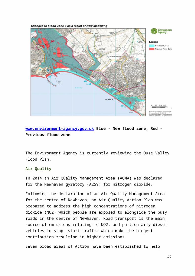
The Environment Agency identified Newhaven as an area that has seen a change at the coastal frontage impacting on the extent of Flood Zone 2 and 3.
This means that there was an increased coastal flood risk with flooding coming from wave overtopping and not from high tides. Although the new flood depths associated with the new outlines were generally shallow and the overall risk of flooding is likely to be low flood alleviation works started in January 2017 and are scheduled to be complete by autumn 2019 with the scheme divided into 5 areas:
30

Area 1: A26 to Energy Recovery Facility
Area 2: Energy Recovery Facility to Swing Bridge (East)
Area 3: Riverside Park to Swing Bridge (West)
Area 4: Swing Bridge (West) to West Quay
Area 5: Swing Bridge (East) to Newhaven Beach.
The scheme will be designed to provide a 1-in-200-year standard of protection, taking into account the effects of climate change. This means that in any one year there will be a 0.5% chance that Newhaven will experience flooding from the sea. This greatly increases the flood protection to Newhaven.
In addition to homes and businesses, the scheme will also reduce the risk of flooding to local infrastructure such as the road network, railway line and a train station. It will support the wider regeneration of Newhaven, helping to bring new investment, jobs and homes to the area.
The scheme covers both banks of Newhaven, including the commercial areas near the port.
www.environment-agancy.gov.uk Blue - New flood zone, Red - Previous flood zone
31

The Environment Agency is currently reviewing the Ouse Valley Flood Plan.
Air Quality
In 2014 an Air Quality Management Area (AQMA) was declared for the Newhaven gyratory (A259) for nitrogen dioxide.
Following the declaration of an Air Quality Management Area for the centre of Newhaven, an Air Quality Action Plan was prepared to address the high concentrations of nitrogen dioxide (NO2) which people are exposed to alongside the busy roads in the centre of Newhaven. Road transport is the main source of emissions relating to NO2, and particularly diesel vehicles in stop- start traffic which make the biggest contribution resulting in higher emissions.
Seven broad areas of Action have been established to help deliver better air quality, with specific measures then identified for each of these Actions areas. The categories of Action are as follows:
Action 1: Enable the use of sustainable travel choices through the delivery of transport infrastructure and initiatives
Action 2: Actively promote low emission vehicles and supporting infrastructure.
Action 3: Use the planning system to ensure that air quality is fully considered for new development.
Action 4: Use traffic management to reduce emissions within the AQMA.
Action 5: Work with Public Health colleagues to inform the public about health impacts of Air Pollution and how they can change behaviour to reduce emissions and reduce exposure.
Action 6: Continue to monitor and assess air quality in line with Government guidance on Local Air Quality Management (LAQM).
Action 7: Target point sources in Newhaven Town Centre
32

33
Key Issues and Comments
Improvement needed to public realm within town centre for community and visitors Strengthen connectivity of retail areas east and west of the river Improvement to quality and signage of routeways within the town to join up
different neighbourhoods Severance impact of ring road on town centre Severance impact of river between east and west sides of the town Poor environmental quality to town centre gateways Industrial ‘clutter’ on North Quay (outside Neighbourhood Plan scope as not within
NP designated area) Visual impact of older industrial/employment areas Stark contrast between urban and rural landscapes Importance of urban and rural landscapes on tourism when approaching town from
the sea Flood risk identified to areas within the town Unprotected cliffs Impacts of Climate Change Poor air quality in congested parts of the town with action orientated approach to
ameliorate

Appendix 1 - Review of Newhaven evidence base documents
Evidence Base Document
Summary of Content
Key Messages Over-arching and recurring themes
Lewes District Shopping and Town Centres Study 2012
A district-wide shopping and town centres study assessing the District’s main shopping and smaller village/rural centres. The purpose of the study is to inform and guide retail planning and development in the District and to form a robust evidence base for the preparation of the Council’s Local Development Framework Core Strategy.
Newhaven town centre has seen significant decline in its retail attraction and function over recent years. The town centre now has a very limited level of retail and retail service provision and the town centre’s environment has been negatively affected as a result. Newhaven town centre does not perform well and there is no identified quantitative need for additional convenience floorspace. This underperformance is in stark contrast to the stronger trading exhibited by the out of town retailing. The town centre has very limited and poor-quality comparison goods shopping. The main food convenience shopping function at Newhaven is fulfilled by the Sainsbury’s superstore located to the east of the town centre at the Drove. It is a large modern store
The town centre now has a very limited level of retail and retail service provision.
The town centre’s environment has been negatively affected as a result.
This underperformance is in stark contrast to the stronger trading exhibited by the out of town retailing.
There remains a reasonable range and choice of retail service type uses available in terms of restaurants, cafes, estate agents and hairdressers’ banks etc. It is broadly considered that it is this retail service provision rather than the shopping offer which now motivates visits to the town
34

Evidence Base Document
Summary of Content
Key Messages Over-arching and recurring themes
with extensive ranges of food and grocery goods. In addition, in this area there is a Lidl store which further adds to the out of-centre retail provision at Newhaven.
Notwithstanding the poor level of shopping provision within Newhaven town centre, there remains a reasonable range and choice of retail service type uses available in terms of restaurants, cafes, estate agents and hairdressers’ banks etc. It is broadly considered that it is this retail service provision rather than the shopping offer which now motivates visits to the town centre.
Accessibility into Newhaven town centre is via a poorly signed routes off the A259 (North Way/South
Way) which forms a busy gyratory around
centre.
Accessibility into Newhaven town centre is via a poorly signed routes off the A259.
Stranglehold of the A259 around the town centre.
More should be made of the historical context of Newhaven and the river corridor and marina.
35

Evidence Base Document
Summary of Content
Key Messages Over-arching and recurring themes
the town centre area.
Stakeholder feedback on Newhaven highlighted the effective stranglehold of the A259 around the town centre as an important issue to address. Other issues highlighted included:
• The loss of Woolworths from the town centre was significant and trade has fallen since then.
• Apart from the Co-Op there is no other retail-based reason to go into the town centre.
• Local impression is of a ghost town, with little or no reason to invest in the town centre.
• The multi-storey car park should be removed.
• More should be made of the historical context of Newhaven and the river corridor and marina.
36

Evidence Base Document
Summary of Content
Key Messages Over-arching and recurring themes
Lewes District Hotel & Visitor Accommodation Futures 2009
Commissioned by Lewes District Council and Tourism South East to provide an objective assessment of the potential for the future development of hotels, guesthouses and other forms of serviced accommodation in Lewes District.
The study suggests less potential for new accommodation development in Seaford, Peacehaven and Newhaven, other than possibly further budget hotel development in Newhaven, for which there was developer interest.
There is likely to be some corporate business in Newhaven.
The possible expansion of Newhaven Port facilities and development of Newhaven Eastside could generate increased demand for hotel accommodation in Newhaven from the corporate and contractors market in the longer term. Housing development here may also generate increased demand from the visiting friends and relatives market.
Possibly further budget hotel development in Newhaven. There is likely to be some corporate business in Newhaven.
37

Evidence Base Document
Summary of Content
Key Messages Over-arching and recurring themes
Lewes District Local Plan Part 1 May 2016
Adopted Local Plan Part 1 - Joint Core Strategy produced by Lewes District Council and South Downs National Park Authority working in partnership. It promotes sustainable development and sets out the scale, type and location of key development proposed in the district to 2030.
Vision for Newhaven:
By 2030, Newhaven will have undergone significant regeneration and developed and strengthened its economic base. The town will have become the focus for enterprise and training within the
Spatial Policy 2 – Distribution of Housing
Land at Harbour Heights, Newhaven – 400 net additional units.
Newhaven – a minimum of 425 net additional units
Regeneration of the district’s coastal towns is a key objective of this plan. Key to this will be regeneration at Newhaven and growth will have a significant role to play in achieving this transformation.
Housing growth is considered pivotal in helping to achieve regeneration at Newhaven. As well as supplying much needed housing within an area of need, additional housing in Newhaven will also bring about significant investment into the town, including improvements to
Regeneration at Newhaven and growth will have a significant role to play in achieving this transformation.
Housing growth is considered pivotal in helping to achieve regeneration at Newhaven.
Provision of smaller, high quality premises within Newhaven, particularly move-on office units.
Newhaven is currently recognised as having a shortfall in equipped children’s play space and sports pitches.
There is a strong community and a sense of pride.
38

Evidence Base Document
Summary of Content
Key Messages Over-arching and recurring themes
district, with links to the two universities in Brighton. Much of the economic regeneration will have centred upon port generated activities, high-tech industries and the tourism industry with the town acting as the continental gateway to the adjacent National Park. The regeneration of Newhaven will have resulted in a revitalised and more accessible town centre, with an improved public realm and a greater range of uses and activity, including those to meet local needs.
The improved accessibility of the town centre will have been aided by an improved highway network, greater connectivity to the town’s railway
infrastructure and the creation of jobs, and a larger population base to support the existing businesses, including town centre retailers, which operate in the town.
Provision of smaller, high quality premises within Newhaven, particularly move-on office units suitable to accommodate businesses seeking to move-on from the
Enterprise Centre.
Newhaven is currently recognised as having a shortfall in equipped children’s play space and sports pitches.
There is a strong community and a sense of pride in the town with over 150 active community groups and a successful community development association.
Development and job-creation opportunities related to the Port are considered vital to the regeneration of Newhaven and the surrounding coastal area.
Support the remaining retail function within Newhaven town centre
39

Evidence Base Document
Summary of Content
Key Messages Over-arching and recurring themes
stations and a high quality sustainable transport corridor along the A259. The natural asset of the river through the town will have been maximised through redevelopment opportunities, thereby enhancing this unique area of the town for residents and visitors alike.
Newhaven Port is an important strategic asset both for the district and the wider region. Development and job-creation opportunities related to the Port are considered vital to the regeneration of Newhaven and the surrounding coastal area
In order to support the remaining retail function within Newhaven town centre, which fulfils an important local role, a diversity of commercial and community/cultural uses will be encouraged in the town centre to encourage greater footfall in the area and more linked trips with the retail units. Residential use may be appropriate within Newhaven town centre when other alternative uses are not forthcoming.
40

Evidence Base Document
Summary of Content
Key Messages Over-arching and recurring themes
East Sussex Sustainable Community Strategy 2009 – Lewes Chapter
In East Sussex, the six local authorities and six Local Strategic Partnerships have worked together to produce Pride of Place - the sustainable community strategy for East Sussex. It sets out a long term vision for improving people’s quality of life and the main things we must do to achieve that vision. Pride of Place focuses on the issues and priorities that local people have told us they are most concerned about:
Priorities for Newhaven:
1. Create a learning community
2. Improve health and community wellbeing
3. Improve community life
4. Help businesses grow
5. Encourage new business
6. Make Newhaven more accessible
7. Revitalise Newhaven’s port
8. Maximise tourism opportunities
9. Create a busy town centre
10. Promote riverside development and provide appropriate housing with supporting infrastructure
11. Maintain an attractive and well used environment.
Improve health and community wellbeing
Encourage new business
Maximise tourism opportunities
Create a busy town centre
Promote riverside development
Attractive and well used environment
Lewes Informal This study reviews Both Newhaven West Newhaven West
41
Evidence Base Document
Summary of Content
Key Messages Over-arching and recurring themes
Recreation Space study 2005
and assesses the current provision of informal recreation space in Lewes District, its current qualitative, character and quantaitive provision and the location of any deficits
Beach and Lewes river frontage are seen as opportunities to provide good and attractive recreational space for their towns, at present under-utilised. These potentially very attractive recreational spaces needs vitalising, but should stay natural in character.
The towns, Peacehaven and Seaford on the coast and Lewes and Newhaven on the Ouse, have larger amenity areas, such as the Salts at Seaford, and a wider variety of informal recreational areas and sports fields, but their centres, in places, lack the easy accessibility of the public footpaths giving a short walk’s access into the countryside, that the villages have.
Newhaven has the benefit of its setting to provide exciting recreational space; the
Beach is seen as an opportunity to provide good and attractive recreational space, at present under-utilised.
Centres, in places, lack the easy accessibility of the public footpaths giving a short walk’s access into the countryside.
The river acts as a severing agent, cutting the town in half. The ring-road in the centre has a similar effect.
Older parts of the town have little civic or amenity greenspace.
Central parts of Newhaven, on either side of the river are deficient in accessible greenspace.
42

Evidence Base Document
Summary of Content
Key Messages Over-arching and recurring themes
river, the port, the downs and the sea.
• The river, while providing wonderful character, acts as a severing agent, cutting the town in half, thus reducing linkages across. The ring-road in the centre has a similar effect.
• Older parts of the town have little civic or amenity greenspace, which indicates the need for pocket parks and improved linkages where possible.
• Every opportunity should be explored and taken to enhance the river spaces and the beach to provide high quality and characterful recreational spaces.
Newhaven’s setting enables local people in the north, west and southern parts to have access to the surrounding countryside; downland, sea cliffs, river
There is no area of parkland with high quality gardens.
43

Evidence Base Document
Summary of Content
Key Messages Over-arching and recurring themes
landscapes and seaside.
• However, much of the central parts of Newhaven, on either side of the river are deficient in accessible greenspace
• People in the Town Centre lack access to areas high quality civic space.
• There is no area of parkland with high quality gardens, but areas such as West Quay offer a high quality amenity area of a maritime character.
Lewes Local Plan Infrastructure Delivery Plan 2018
This Infrastructure Delivery Plan (IDP) has been produced to accompany the Lewes District Local Plan. It sets out the key strategic infrastructure that is required to support the objectives and spatial strategy of the Local Plan
A new port access road (PAR) in Newhaven is a long-standing proposal of ESCC. The final phase across Mill Creek and the railway is anticipated to be completed in 2020.
In Newhaven, the studies demonstrate that the town’s highway network can currently accommodate existing traffic demands
By 2030 forecast background traffic growth will result in traffic volume exceeding junction capacity during the PM peak.
Current traffic demands on the Newhaven town centre one-way system means that there is only limited capacity on these
44

Evidence Base Document
Summary of Content
Key Messages Over-arching and recurring themes
in both the AM and PM peaks. However, by 2030 forecast background traffic growth will result in traffic volume exceeding junction capacity during the PM peak at:
The Drove slip merge with the A259 just east of the swing bridge
The swing bridge and the town centre one-way system A259/Denton Island junction
Current traffic demands on the Newhaven town centre one-way system and also the A259 west of Peacehaven means that there is only limited capacity on these parts of the highway network to accommodate an increase in demands arising from future development in Newhaven or Peacehaven.
parts of the highway network to accommodate an increase in demands arising from future development in Newhaven.
Additional secondary school places are required to support development in Newhaven
45

Evidence Base Document
Summary of Content
Key Messages Over-arching and recurring themes
Additional secondary school places are required to support development in Newhaven, Peacehaven and Telscombe with a shortfall of Year 7 places beginning to emerge from September 2019, reaching potentially 450 places (three forms of entry) during the next decade.
Neighbourhood Plan survey report 2014
This survey was developed and undertaken by the Neighbourhood Plan Steering Group. The survey aims to build on their work by consulting with residents on the draft vision and draft objectives.
Selection of comments:
There is a lot of phrasing around 'green' policies, but it ignores the 'elephant in the room ‘which is the current traffic system around the town (which virtually isolates and disconnects the town centre from the town like some medieval moated fortress). Any piecemeal proposals will be 'sticking plaster' until the issue of rerouting the A259 with a permanent bridge north of the town is discussed.
Make more of the
Current traffic system around the town which virtually isolates and disconnects the town centre from the town.
Unique location between the Sea and the Downs, including the maritime and fishing heritage.
Creation of a town centre.
Car parking should be free in the town.
46

Evidence Base Document
Summary of Content
Key Messages Over-arching and recurring themes
unique location between the Sea and the Downs, including the maritime and fishing heritage and everything associated with the riverside banks.
No consideration has been given to the creation of a town centre. As everyone who lives in Newhaven, along with visitors who come into Newhaven, can see there is no town centre!! This needs to be addressed before any further changes take place. The tragic legacy of years ago when some outsider decided to put a 'ring road' around the then buoyant town centre, which spelt the beginning of the end of the town to what now exists .........which is absolutely nothing!!
Car parking should be free in the town. Shop keepers need to be encouraged to be
47

Evidence Base Document
Summary of Content
Key Messages Over-arching and recurring themes
there, banks need to be in the town otherwise it just encourages people to go to Seaford.
Neighbourhood Plan Town Centre survey report 2015
This survey was developed and undertaken by the Newhaven Neighbourhood Plan Focus Group in conjunction with the Steering Group and the Town Council to guide as part of the consultation exercise to inform the neighbourhood plan.
What facilities and services would you like to see in the Town Centre?
Banks stood out and some mentions of cash dispensers. There was a longing for a variety of shops including unique ones and nationally recognised chain stores. More proper food stores were required.
Decent restaurants and bars with good seating areas whilst shopping. It was highlighted that because of the lack of shops and the infrequency of buses, older people who catch the bus into the towns and have nothing else to do after buying what they needed would benefit from somewhere to sit.
Variety of shops including unique ones and nationally recognised chain stores. More proper food stores were required.
Decent restaurants and bars with good seating areas whilst shopping.
The empty shops and lack of better food and clothing stores
Generally parking charges were also least liked
48

Evidence Base Document
Summary of Content
Key Messages Over-arching and recurring themes
What do you like best about the Town centre?
A majority of those responding said nothing was liked! The library seems to be a centre of attraction at the moment but concerns about it closing at 1pm and not opening at all on Wednesday was a worry. People also like the Pound Stretcher and interestingly the style of the old buildings.
What do you like least about the Town centre?
The empty shops and lack of better food and clothing stores got the most mention. The multi-storey car park also got mentioned as being ugly, dark and scary as well as a stairway by the library. There were mentions of a car park by Lower Road where the bus turns. Generally parking charges were also least liked as it deters people from visiting a centre they believe has not got
49

Evidence Base Document
Summary of Content
Key Messages Over-arching and recurring themes
much to offer.
Newhaven Air Quality Action Plan 2016
Following the declaration of an Air Quality Management Area for the centre of Newhaven, an Air Quality Action Plan has been prepared to address the high concentrations of nitrogen dioxide (NO2) which people are exposed to alongside the busy roads in the centre of Newhaven.
Seven broad areas of Action have been established to help deliver better air quality, with specific measures then identified for each of these Actions areas. The categories of Action are as follows:
Action 1: Enable the use of sustainable travel choices through the delivery of transport infrastructure and initiatives
Action 2: Actively promote low emission vehicles and supporting infrastructure.
Action 3: Use the planning system to ensure that air quality is fully considered for new development.
Action 4: Use traffic management to reduce emissions within the AQMA.
Action 5: Work with Public Health colleagues to inform
Enable the use of sustainable travel choices
Use the planning system to ensure that air quality is fully considered for new development.
50

Evidence Base Document
Summary of Content
Key Messages Over-arching and recurring themes
the public about health impacts of Air Pollution and how they can change behaviour to reduce emissions and reduce exposure.
Action 6: Continue to monitor and assess air quality in line with Government guidance on Local Air Quality Management (LAQM).
Action 7: Target point sources in Newhaven Town Centre
Newhaven Eastside Masterplan 2006
A strategy for the land on the east bank of the River Ouse at Newhaven, which includes the Port of Newhaven, the established Eastside industrial area, the proposed Eastside Business Park, the railway and railway stations and the Eastside residential neighbourhood.
Looked at three spatial development options:
Option C, based upon existing planning strategies, is consistent with the retention of port facilities and supporting continued industrial employment in the town, whilst still allowing for development of residential uses on Railway Quay. It provides the best balance of housing and job opportunities to meet Newhaven’s needs. However, this
Retention of port facilities and supporting continued industrial employment in the town, whilst still allowing for development of residential uses on Railway Quay
51

Evidence Base Document
Summary of Content
Key Messages Over-arching and recurring themes
option requires public finding of a new access road to serve the industrial estate or port.
Newhaven Economic Plan CCT, 2017
Coastal Community Team has produced an Economic Plan for Newhaven. In accordance with the guidance - n. Each Plan will need to contain information on the needs of the area and the challenges it faces.
Current higher evidence of single person households need through LDC Housing needs survey.
Relatively low choice of detached homes in the existing housing stock and therefore smaller choice of homes to aspire to.
Pockets of poorer health which may generate the need for homes suitable for adaptation
Higher long term sickness
Relatively higher unemployment with 13% claiming out of work benefits
Less retired Higher rate of long
term unemployment (both male and female) including the 16-24 years age range
Lower percentage of people work from home
Higher incidence of
Low choice of detached homes in the existing housing stock.
Relatively higher unemployment with 13% claiming out of work benefits. Less retired.
Predicted shortfall in early years, primary school and secondary school provision.
Undersupply of formal recreation provision and play space. Older parts of the town have little public amenity space
Town centre no longer the heart of the community as
52

Evidence Base Document
Summary of Content
Key Messages Over-arching and recurring themes
people walking and cycling to work suggests local employment opportunities
Predicted shortfall in early years, primary school and secondary school provision
Relatively poorer educational achievement
Undersupply of formal recreation provision and play space. Older parts of the town have little public amenity space
Natural and man-made elements sever parts of the town from one another
A259 which is a heavily congested urban road and to the trunk road network by the A26.
Notwithstanding these issues, there is a strong sense of community in the town.
Threats
Town centre no longer the heart of the community as almost derelict apart from
almost derelict apart from opening of new library.
Lack of morale an issue for community as they feel their town has been forgotten.
53

Evidence Base Document
Summary of Content
Key Messages Over-arching and recurring themes
opening of new library. Need to develop this area and reinvent it as Community Hub and attract a range of uses including those for community use such as cafes and services and facilities. Lack of morale an issue for community as they feel their town has been forgotten. Need to help develop pride through new initiatives and investment.
Newhaven Employment Land Review 2017
The purpose of the ELR is to inform the Council’s approach to employment land in the town and specifically to review the evidence in respect of the potential implementation of Article 4 Directions on suitable sites within Newhaven.
Newhaven’s key attractions as a business location include its relatively low-cost land and rents compared with other parts of the Sussex coast, lower wage costs, and historically, land availability compared to more constrained locations such as Brighton and Hove.
Potential drawbacks include a lower profile image as a business location, limited
Key attractions as a business location include its relatively low-cost land and rents lower wage costs, and historically, land availability.
Lower profile image as a business location, limited strategic road access and traffic congestion, alongside a limited supply of highly skilled labour.
54

Evidence Base Document
Summary of Content
Key Messages Over-arching and recurring themes
strategic road access and traffic congestion in some parts of the town, alongside a limited supply of highly skilled labour.
Much of the town’s industrial stock is dated and of relatively poor quality. There was a general view amongst agents that some of the older industrial space in Newhaven could be demolished since a significant proportion has reached the end of its economic life.
Newhaven is not characterised as a significant office centre. As a whole, Lewes District has recorded limited success in attracting new investment in recent years, and this trend is reflected in Newhaven town.
Town has suffered from decades of under-investment and it is
Industrial stock is dated and of relatively poor quality.
Town has suffered from decades of under-investment
55

Evidence Base Document
Summary of Content
Key Messages Over-arching and recurring themes
clear that the market is unable and unwilling to deliver the various sites.
Newhaven Enterprise Zone Evidence Base (incl SWOTs)
Background evidence as part of EZ application 2015
The town has a relative skills deficit. Amongst all the comparator areas, Newhaven has both the highest proportion of residents with no qualifications (17%) and the lowest proportion of residents with a degree level qualification or higher (20%). The skills gap compared to the wider area is stark, particularly the shortfall of people with Level 4+ qualifications – which is 12 percentage points lower than Lewes District and 14 percentage points lower than the average for C2C LEP.
Newhaven is heavily dependent on manufacturing employment, which employs over 1,000 people locally. The town is also dependent
The town has a relative skills deficit.
Newhaven is heavily dependent on manufacturing employment.
Employment in professional and business services is relatively limited.
Newhaven is characterised by its established industrial stock – predominantly older industrial and warehousing units.
Little sense of community and place.
56

Evidence Base Document
Summary of Content
Key Messages Over-arching and recurring themes
on retail (850 jobs), health (550) and transport & storage (500 jobs), which will include port related activity. Other specialist but smaller employment sectors include wholesale and mining, quarrying & utilities.
Conversely employment in professional and business services is relatively limited and these sectors are under-represented in Newhaven.
Newhaven is characterised by its established industrial stock – predominantly older industrial and warehousing units and typically under 20,000 sq ft. Indeed, over 70% of designated employment floorspace was built before 1970. There is little modern office accommodation.
Poor accessibility
57

Evidence Base Document
Summary of Content
Key Messages Over-arching and recurring themes
• Poor accessibility and rail links (exacerbated recently by the Southern Railways strikes and lack of confidence in being able to travel)
• Little sense of community and place (the one-way system essentially cuts off the town centre from the railway station, ferry terminal and Railway Quay)
• Rapid obsolescence of ageing industrial buildings and limited availability of quality stock (most obviously on the Avis Way estate)
• Limited room to expand on existing premises
• Flooding issues (though this is currently being dealt with by the Environment Agency and upgrades should be completed this year)
• An inability at present to capitalise on the economic pressures in
58

Evidence Base Document
Summary of Content
Key Messages Over-arching and recurring themes
Brighton.
Newhaven Enterprise Zone Strategic Framework 2018
The focus of the strategic framework for the Enterprise Zone is to act as the catalyst for positive growth in Newhaven, which would not happen so readily without the practical incentives for business, and shared ambition for the economic success of the town brought by the Enterprise Zone designation.
Increasing concern that disadvantaged groups and areas do not always benefit from economic growth in the form of new jobs and increased income.
Historic legacy of piecemeal development and perceived bad development has created a community with a mistrust of local government, and an anti-growth lobby. No proposition to business as to ‘why locate?’, or to visitors to the area; hence no clearly defined ambition
KEY CHALLENGES
Access to funding for place-making is very difficult; public funding is increasingly competitive for ‘non-essential’ capital works, and private sector schemes need return on investment.
Disadvantaged groups and areas do not always benefit from economic growth.
Piecemeal development and perceived bad developments.
No clearly defined ambition.
Access to funding for place-making is very difficult.
Disparate private sector ownership of key town centre commercial properties and poor town centre offer.
Under-supply of quality recreation
59

Evidence Base Document
Summary of Content
Key Messages Over-arching and recurring themes
Disparate private sector ownership of key town centre commercial properties and poor town centre offer Under-supply of quality recreation and public realm space. Poor perception of Newhaven as a place to visit; losing visitors who do arrive in the town, particularly via the ferry, and are not encouraged to stay.
Self-employment and start-up rates are low locally, relative to the regional context.
Historically, weak partnership collaboration and engagement between business support and skills providers.
Lack of quality business infrastructure; commercial space, access to technology and capital equipment,
and public realm space.
Poor perception of Newhaven as a place to visit.
Self-employment and start-up rates are low locally, relative to the regional context.
Low level engagement and dialogue with local enterprises.
Lack of quality business infrastructure; commercial space.
High remedial costs associated with brownfield development sites.
Severance of the town by both the ring road, swing bridge and river is
60

Evidence Base Document
Summary of Content
Key Messages Over-arching and recurring themes
and sector specific support.
Low level engagement and dialogue with local enterprises, which limits the understanding of what is required to grow, scale and sustain, that is specific to Newhaven.
Currently little collaboration and/or interaction between local companies, in part due to the local economic structure and nature of the supply chain
Insecure resourcing and capacity in community-led organisations and local third sector providers limits impact and sustainability of outcomes.
At GCSE level, students underperform compared to East
considerable.
Poor location perception as a place to work and visit.
Low choice of detached homes to aspire to for families.
Local firms finding it hard to expand or upgrade to more suitable premises locally.
61

Evidence Base Document
Summary of Content
Key Messages Over-arching and recurring themes
Sussex and national average. Lower skills level apprenticeships more prevalent in Newhaven comparative to Coast to Capital Local Enterprise Partnership area
Newhaven’s population is lower skilled on average compared to Coast to Capital Local Enterprise Partnership area - particular disparity with no skilled, and degree level, when comparing area attainment
Newhaven is characterised by predominantly older industrial stock, typically under 20,000 square feet, with
little change in rental values and yields
High remedial costs associated with brownfield development sites (contamination and
62

Evidence Base Document
Summary of Content
Key Messages Over-arching and recurring themes
flood risk)
Severance of the town by both the ring road, swing bridge and river is considerable
Poor location perception as a place to work and visit Disproportionate number of single households to availability of single occupancy dwellings, and low choice of detached homes to aspire to for families
Dynamics of Newhaven’s commercial market has resulted in local firms finding it hard to expand or upgrade to more suitable premises locally, and consequently new firms unable to locate to Newhaven
Limited road and rail connectivity and resilience restricts people’s travel and
63
Evidence Base Document
Summary of Content
Key Messages Over-arching and recurring themes
efficiency of movement
Road building constraints in South Downs National Park and coastal strip. Air quality and localised flood risk remains a real concern. Competition all around for employment and investment locations – coastal and inland.
Newhaven Marine Cluster Review 2015
The Newhaven Marine Cluster Businesses have been a key part of the town’s economy since Newhaven established itself as a Port. This review has been undertaken following the considerable concern raised by these Businesses over the impact planning and development, along with other factors has on their future.
32 vessels operate out of Newhaven. With a large proportion of the other enterprises supporting them and the wider Port and Marina operations.
There are a wide variety of different types of firms. The Marine Cluster reflects a diverse ecosystem of marine-related enterprises.
Unlike Newhaven’s manufacturing sector where many of the
The Marine Cluster reflects a diverse ecosystem of marine-related enterprises.
Marine Cluster’s workforce is resident locally.
Two-thirds of the customers of the Cluster come from outside of Newhaven.
Facilities supporting the marine trades in this town have
64

Evidence Base Document
Summary of Content
Key Messages Over-arching and recurring themes
employees commute into Newhaven form Brighton and elsewhere, most of the Marine Cluster’s workforce is resident locally, reflecting the central role which the Cluster plays in the Newhaven economy
Two-thirds of the customers of the Cluster come from outside of Newhaven, bringing further economic benefits to the town.
Facilities supporting the marine trades in this town have shrunk year on year with less facilities to lift vessels ashore, storage areas, slipway services (now the last slipway has gone at Cantell’s) and general ship wrighting services are also shrinking.
shrunk year on year
Newhaven Port NPP and its Newhaven itself has a Newhaven has a
65

Evidence Base Document
Summary of Content
Key Messages Over-arching and recurring themes
Masterplan 2012 partners have developed the Port Masterplan (PMP) for the port of Newhaven to form a strategic framework from which the port will develop over the next 20 to 30 years.
tradition of skilled manufacturing, and around 30% of the workforce remains employed in this sector - close to three times the national average. As a result, Newhaven has a significant legacy of industrial buildings, both in and adjacent to the port, which can support new manufacturing jobs.
Against that, Newhaven is facing a number of significant challenges:
• Low levels of entrepreneurship and business start-ups;
• A business community that is focused on local markets, rather than international markets;
• Stagnant business and employment growth and lower
productivity than national averages;
• Low skills level in some areas, particularly
significant legacy of industrial buildings.
Low levels of entrepreneurship and business start-ups.
A business community that is focused on local markets, rather than international markets.
Low skills level in some areas
66

Evidence Base Document
Summary of Content
Key Messages Over-arching and recurring themes
young people;
• Low income per household;
• Competition from Brighton, Portsmouth and
Southampton; and
• Low skills level in some areas
Physical Development Vision for Newhaven
Stage 2 2010
A 20-year Physical Development Vision (PDV) for Newhaven.
Need for a comprehensive approach to developing the Vision for Newhaven, in particular highlighting that the town must not be seen in isolation, but as part of a wider functioning economic area.
One of the key messages emerging from this study is that there is no “silver bullet” that will make Newhaven a more prosperous, sustainable place; rather, a combination of coordinated actions will be required over a long period.
No “silver bullet” that will make Newhaven a more prosperous, sustainable place.
Several constraints with respect to the highway and public transport network, with delays common in the peak hours.
Historic core of the town centre is an asset that has in part, been blighted by post war development.
The ring road currently severs links between the historic
67

Evidence Base Document
Summary of Content
Key Messages Over-arching and recurring themes
Newhaven currently suffers from several constraints with respect to the highway and public transport network, with delays common in the peak hours.
The historic core of the town centre remains in key areas, but is an asset that has in part, been blighted by post war development. The ring road currently severs links between the historic town centre and the rest of the town for both local residents and those passing through the town. The traditional retail role of the town centre has become increasingly marginal in recent years.
Newhaven has the lowest provision of equipped play space in the District, and improving this is a
town centre and the rest of the town.
The traditional retail role of the town centre has become increasingly marginal in recent years.
Lowest provision of equipped play space in the District.
Poor quality environment and generally.
Education, skills and training is the domain on the Index of Multiple Deprivation (IMD) in which Newhaven performs worst,
68

Evidence Base Document
Summary of Content
Key Messages Over-arching and recurring themes
Priority.
Key employment sectors that should be built upon in the future economic growth of Newhaven (in addition to alternative energy above) include Advanced Manufacturing and Engineering, the Visitor Economy, the Food Sector, and Creative Industries, Culture and IT.
Residential areas surrounding Newhaven town centre often have a poor quality environment and generally there is a shortage of low cost housing.
Education, skills and training is the domain on the Index of Multiple Deprivation (IMD) in which Newhaven performs worst, and this has been recognised as being detrimental to the
69

Evidence Base Document
Summary of Content
Key Messages Over-arching and recurring themes
town’s development.
The People’s Report 2012
Represents views and aspirations for the town. The People’s Report has one main aim; to provide a clear signal about what people want for Newhaven and provide a people’s view on their aspirations for Newhaven in the future.
People feel part of the town and have positive things to say about its potential, its location and natural assets and beauty spots. However, there is a strong feeling that Newhaven has stood still or even gone backwards in some respects. The general view is that Newhaven needs to move forward and move forward fast. Provision and the safeguarding of employment opportunities were also highlighted as a priority. Therefore, any development opportunity that creates new permanent jobs was seen as a good thing for the town.
Commercial ventures such as cinema, shops, restaurants, cafes and factories received significant support, with the overall view in favour of anything that will create jobs for
There is a strong feeling that Newhaven has stood still or even gone backwards in some respects.
Provision and the safeguarding of employment opportunities were also highlighted as a priority.
Commercial ventures such as cinema, shops, restaurants, cafes and factories received significant support, with the overall view in favour of anything that will create jobs for locals.
Establishing a new retail centre was seen as key.
The view was that there was a need for
70

Evidence Base Document
Summary of Content
Key Messages Over-arching and recurring themes
locals. This was highlighted by the comments that simply stated “build anything that creates jobs.” The general view was that the run down impression of the town, particularly the port area, needed to be reversed and new development was seen as one of the best ways of achieving this.
Whilst new development was welcomed, this was not to be at the expense of adjoining countryside and should provide a variety of facilities and enhance the environment of the town.
Whilst providing an additional supermarket was not seen as a priority, establishing a new retail centre was seen as key, and the role of a supermarket in this was recognised as was the need for good integrated transport
more open space and facilities, with better access to these and existing natural features.
Most people blamed the ring road for the demise of the town centre. It was felt that car parking charges should be addressed as well as environmental enhancements to encourage visits into the town centre.
The image of the town was one of being run down, particularly for visitors
71

Evidence Base Document
Summary of Content
Key Messages Over-arching and recurring themes
arrangements.
Many people felt that some of the open space was ‘just right and should be left as it is,’ whilst other areas have huge potential for additional facilities. In general, the view was that there was a need for more open space and facilities, with better access to these and existing natural features.
Most people blamed the ring road for the demise of the town centre. It was felt that car parking charges should be addressed as well as environmental enhancements to encourage visits into the town centre. It was generally accepted that the main retail area had moved to the east of the river.
The town centre was still valued as a focal point, but people
72

Evidence Base Document
Summary of Content
Key Messages Over-arching and recurring themes
recognised that a new role was needed if it was to be revitalised.
Whilst the majority of residents believed that the town has many assets and good features, they felt that the image of the town was one of being run down, particularly for visitors entering via the port, and this was the main barrier in attracting people to stop in the town.
Town Centre Concept
Masterplan and
Options Study
November 2016
To assist the NTC to explore masterplanning issues and design concepts relating to the redevelopment and improvement of the Town Centre.
The Town Centre core is surrounded by a ring road - North Way / Lewes Road - with multiple access points along it. Due to its engineering solution, it joins the Town centre at different levels; sometimes at street level and others it is raised from the immediate areas. This creates a dislocation and discontinuity with rest of the surrounding streets.
A significant amount of vehicular traffic along the ring road which in turn creates severance with other parts of the town and an unpleasant pedestrian experience when accessing the town on foot.
An introverted Town Centre with backs facing the road.
73

Evidence Base Document
Summary of Content
Key Messages Over-arching and recurring themes
East - west vehicular movements that do not stop in the Town centre go around the ring road. This concentrates a significant amount of vehicular traffic along the ring road which in turn creates severance with other parts of the town and an unpleasant pedestrian experience when accessing the town on foot.
Similarly, the layout of the town combined with the ring road disposition, creates an introverted Town Centre with backs facing the road. This results in a poor outlook from the Town and thus feels uninviting.
Access points to the Town centre core are visually unattractive and unappealing. Pedestrian and vehicular gateways to
Access points to the Town centre core are visually unattractive and unappealing.
Building facades look unattractive, tired and in need of maintenance.
Outdated and unappealing street furniture.
Town centre is pedestrian unfriendly and uninviting with most of the space shared with vehicles and used for car park uses.
74

Evidence Base Document
Summary of Content
Key Messages Over-arching and recurring themes
the Town centre are not clearly identifiable from the ring road.
• Building facades look unattractive, tired and in need of maintenance. A poor public realm appearance along with outdated and unappealing street furniture, signage and shop fronts contribute to a poor visual appearance of the streetscape in general.
• Cars parked along High Street and Bridge Street and in the inner part of the built-up area are visually intrusive, reduce the quality of the area and ruin overall Town centre street scene.
• The severance created by the raised ring road around the Town centre along with the presence of underpasses has generated a visible poor and unpleasant pedestrian experience when accessing the town on foot.
75

Evidence Base Document
Summary of Content
Key Messages Over-arching and recurring themes
• The presence of sub utilised residual spaces and numerous blank walls within the Town centre creates unsafe and unwelcome feeling.
• Town centre is pedestrian unfriendly and uninviting with most of the space shared with vehicles and used for car park uses.
• The Town centre area is an introverted site with a backs and fronts problem due the ring road layout and the internal street disposition. This creates a poor and unattractive outlook when approaching the Town Centre from the ring road and when walking within its core.
Newhaven Port Access Road
Business Case
July 2018
The completion of the Newhaven Port Access Road (NPAR) is a priority investment in the delivery of growth
and regeneration plans for
There is a clear challenge to tackle key internal transport infrastructure bottlenecks and environmental issues in and around Newhaven, in particular relating to the functionality of the
To tackle key internal transport infrastructure bottlenecks and environmental issues.
There is demand for
76

Evidence Base Document
Summary of Content
Key Messages Over-arching and recurring themes
Newhaven A259 and Newhaven Ring Road and the designation of an air quality management area for Newhaven town centre, and improve the town’s connectivity with the wider strategic transport network. This is key to enhancing the prospects for securing new private sector investment in the town.
The case for investment in the completion of the Newhaven Port Access Road centres on its role in unlocking the town’s economic growth potential as a business and residential location.
Enquires from business across the City Region, and from elsewhere, indicate that there is demand for commercial space in Newhaven but the delivery of new commercial development projects is constrained by poor perceived connectivity
commercial space but the delivery of new commercial development projects is constrained by poor perceived connectivity and the poor image.
Ferry users in particular perceive Newhaven to be ‘unattractive’.
Deterioration in the traditional port-related industrial areas.
The current commercial property offer in the town is weak.
There is a current overreliance on low value manufacturing and wholesale/retail trading.
The historic core of the town centre has been blighted and
77

Evidence Base Document
Summary of Content
Key Messages Over-arching and recurring themes
and the poor image created by some of the industrial uses that dominate the town’s gateways.
Ferry users in particular perceive Newhaven to be ‘unattractive’, consequently overall visits and spend by ferry travellers in the town centre is low.
Deterioration in the traditional port-related industrial areas, where dated premises, vacancies, lack of upkeep and low value uses have served to accelerate the decline in property assets.
The current commercial property offer in the town is weak and this has fuelled a lack of diversity among economic activities taking place within the town. There is a current overreliance on low value manufacturing and wholesale/retail
there are high levels of vacant units in the town centre, with a generally weak and increasingly marginal overall retail offer.
Serious housing issues facing local people, including a poor physical environment in some residential areas low provision of equipped play space.
Under provision of jobs in Newhaven with higher than average unemployment.
Below average skills profile and a mismatch between resident workers’ skills and available jobs.
Lower than average earnings
78

Evidence Base Document
Summary of Content
Key Messages Over-arching and recurring themes
trading.
The historic core of the town centre has been blighted by post war development and there are high levels of vacant units in the town centre, with a generally weak and increasingly marginal overall retail offer.
The existing ring road severs links between the historic town centre and the rest of Newhaven and several local highway constraints have resulted in serious congestion and peak hour delays, and contributing to the air quality issues in the town centre. Within the town, these problems are exacerbated by port traffic, vehicles feeding the Energy Recovery Facility and the swing bridge.
Serious housing issues facing local people, including a poor
79

Evidence Base Document
Summary of Content
Key Messages Over-arching and recurring themes
physical environment in some residential areas and a shortage of low cost housing for first-time buyers. Low provision of equipped play space and leisure opportunities exacerbate this.
There are areas of significant coastal and fluvial flood risk that are a constraint on new development.
Long-term population growth is driving demand for housing and employment, but there is an under provision of jobs in Newhaven with higher than average unemployment and structural weaknesses in the employment and labour markets.
Below average skills profile and a mismatch between resident workers’ skills and available jobs. There is a significant under
80

Evidence Base Document
Summary of Content
Key Messages Over-arching and recurring themes
provision in higher-value professional, financial and business service jobs, resulting in lower than average earnings with an under representation of higher-value occupations amongst Newhaven’s residents.
81

82