Rampion Offshore Wind Farm Order (SI 2014/1873) …€¦ · location is shown in Figure 1 . 1.3 The...
21
Rampion Offshore Wind Farm Order (SI 2014/1873) Scheduled Monument Written Scheme of Investigation For Archaeological Excavation at Tottington Mount Cross Dyke, Upper Beeding, West Sussex Scheduled Monument no. 31217 February 2015
Transcript of Rampion Offshore Wind Farm Order (SI 2014/1873) …€¦ · location is shown in Figure 1 . 1.3 The...
Rampion Offshore Wind Farm Order (SI 2014/1873)
Scheduled Monument Written Scheme of Investigation
For Archaeological Excavation at Tottington Mount
Cross Dyke, Upper Beeding, West Sussex
Scheduled Monument no. 31217
February 2015
NGR: 521793,111090 (TQ 217 110)
Site Code: TMB15
ASE Project no: 7023
Rampion project number: RAM-ERA-ECO-REP-0020_00
February 2015
Prepared by Sarah Ritchie and Diccon Hart
Archaeology South-East Units 1&2
2, Chapel Place Portslade
East Sussex BN41 1DR
Tel: 01273 426830 Fax: 01273 420866
Website: www.archaeologyse.co.uk
Archaeology South-East Written Scheme of Investigation Excavation: Tottington Mount, Upper Beeding, West Sussex
© Archaeology South-East 1
1.0 Introduction 1.1 E.ON Climate & Renewables UK Rampion Offshore Wind Ltd (E.ON)
has been granted development consent (Development Consent Order (DCO) SI 2014/1873) to construct and operate an offshore wind farm in an area off the Sussex coast including associated onshore infrastructure.
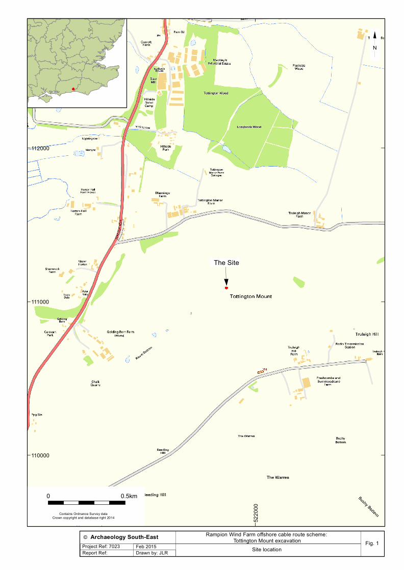
1.2 Archaeology South-East (ASE), the contracting division of The Centre for Applied Archaeology at the Institute of Archaeology, University College London, have been commissioned by RSK Environment Ltd on behalf of E.ON Climate & Renewables UK Rampion Offshore Wind Ltd (E.ON) to undertake a set-piece advance archaeological excavation on the Scheduled remains of a cross dyke at Tottington Mount, Upper Beeding, West Sussex, hereafter referred to as ‘the site’. The site is centred at National Grid Reference (NGR) TQ 21788 11080 and its location is shown in Figure 1.
1.3 The onshore components of the Rampion Offshore Wind Farm include:
• The landfall at Brooklands – the area where two offshore transmission cables come ashore and will be jointed to onshore underground transmission circuits;
• Two onshore underground transmission circuits – which are required
to deliver electricity generated by the offshore wind farm to the National Grid transmission system. The route of the onshore underground transmission circuits is approximately 26.4km long; and
• A new onshore substation– required to facilitate connection to the National Grid 400kV transmission system at the existing National Grid Bolney substation.
1.4 The onshore cabling component consists of a standard 30m wide cable
route for the placement of the two cable circuits, from landfall at Brooklands Pleasure Park to the new onshore substation at Bolney. At various certain locations of environmental constraint (such as the Scheduled cross dyke at Tottington Mount), the working width will be reduced (or ‘pinch-pointed’) to a 15m working width.
1.5 In accordance with the DCO, permission has been granted to mitigate direct impacts to a Scheduled Monument cross dyke on Tottington Mount’ (Scheduled Ancient Monument no. SM31217) through advance archaeological excavation immediately prior to installation of the circuits at this location.
Archaeology South-East Written Scheme of Investigation Excavation: Tottington Mount, Upper Beeding, West Sussex
© Archaeology South-East 2
1.6 The advance archaeological excavation will therefore concentrate on a 15m x 15m area focused on the least well-preserved southern end of the earthwork (see Figure 2).
1.7 This document has been prepared in accordance with DCO Requirement 25 (Scheduled Monument at Tottington Mount), as set out below:
(1) No relevant stage of the connection works shall commence until a methodology for those works that affect the Bronze Age cross-dyke scheduled monument at Tottington Mount (the “scheduled monument”) has been submitted and approved in writing by English Heritage. (2) The methodology approved under paragraph (1) shall form part of the written scheme of investigation provided pursuant to requirement 24 (archaeology in the South Downs National Park), and the relevant stage of the works at the scheduled monument shall be carried out in accordance with the approved methodology. (3) The methodology referred to in paragraph (1) shall include provisions to ensure that equipment and machinery are not used or operated on the scheduled monument in such conditions or in such a manner that is likely to result in damage to the monument or to ground disturbance in the vicinity of the scheduled monument, other than is necessary for the construction and installation of that part of the authorised development that affects the scheduled monument. (4) The undertaker shall provide at least 4 weeks’ notice (or shorter period as may be agreed with English Heritage) of the commencement of the works at the scheduled monument. (5) The undertaker shall provide access to the works at the scheduled monument to facilitate any inspection that English Heritage considers necessary to inspect the works to ensure compliance with the methodology approved under paragraph (1) above. (6) The undertaker shall ensure that all agents and contractors involved in the construction works at the scheduled monument are informed of the following-
(a) the land is designated as a scheduled monument under the Ancient Monuments and Archaeological Areas Act 1979(a); and (b) the extent of the land designated as a scheduled monument, as set out in the scheduled monument description and map on the National Heritage List for England.
Archaeology South-East Written Scheme of Investigation Excavation: Tottington Mount, Upper Beeding, West Sussex
© Archaeology South-East 3
1.8 This document represents a Scheduled Monument Written Scheme of Investigation (SM WSI) which outlines the scope and requirements of the advance archaeological excavation of the designated cross dyke on the site. It has been submitted to English Heritage for approval in its capacity as monitor of method statements and the provisions of Scheduled Monument Consent (SMC), fieldwork and post excavation assessments and final reporting relating to the work at the designated cross dyke on Tottington Mount.
1.9 The WSI has been prepared with reference to the Outline Onshore Written Scheme of Archaeological Investigation (DCO Requirement 24), the relevant standards and guidance documents of the Chartered Institute for Archaeologists (CIfA 2014a; 2014b; 2014c) and the West Sussex County Council (WSCC) recommended standard archaeological conditions for fieldwork (WSCC 2007). All work will be carried out in accordance with these documents (unless otherwise specified below).
Archaeology South-East Written Scheme of Investigation Excavation: Tottington Mount, Upper Beeding, West Sussex
© Archaeology South-East 4
2.0 Archaeological Background Geology and topography
2.1 The underlying geology of the site, according to the latest data from the British Geological Survey (BGS 2015) comprises the Lewes Nodular Chalk Formation. Archaeological background
2.2 The following description of the cross dyke at Tottington Mount is reproduced from the relevant Extract from English Heritage’s Record of Scheduled Monuments (English Heritage 2015), with due acknowledgement. Description of the monument
2.3 The monument includes a roughly north east-south west aligned cross dyke constructed across the northern slopes of a chalk spur which projects to the north west from the main ridge of the Sussex Downs. The 74m long earthwork has a ditch up to about 3m wide and 0.3m deep, flanked to the north-west by a low bank up to about 4m wide and 0.4m high. The earthworks have been partly disturbed by the long term use of a bridleway, which crosses the monument at its south western end. The earthworks fade out at each end as the ground falls away.
2.4 The modern fence which crosses the monument is excluded from the scheduling, although the ground beneath it is included. Assessment of importance
2.5 Cross dykes are substantial linear earthworks typically between 0.2km and 1km long and comprising one or more ditches arranged beside and parallel to one or more banks. They generally occur in upland situations, running across ridges and spurs. They are recognised as earthworks or as cropmarks on aerial photographs, or as combinations of both. The evidence of excavation and analogy with associated monuments demonstrates that their construction spans the millennium from the Middle Bronze Age, although they may have been re-used later. Current information favours the view that they were used as territorial boundary markers, probably demarcating land allotment within communities, although they may also have been used as trackways, cattle droveways or defensive earthworks. Cross dykes are one of the few monument types which illustrate how land was divided up in the prehistoric period. They are of considerable importance for any analysis of settlement and land use in the Bronze Age. Very few have survived to the present day and hence all well-preserved examples are considered to be of national importance.
Archaeology South-East Written Scheme of Investigation Excavation: Tottington Mount, Upper Beeding, West Sussex
© Archaeology South-East 5
2.6 The cross dyke on Tottington Mount survives well, despite some later
disturbance, and will contain archaeological and palaeoenvironmental evidence relating to the construction and original purpose of the monument. Other archaeological sites in the vicinity of the site
2.7 Other archaeological sites within a 500m radius of the site, recorded in the West Sussex Historic Environment Record and as summarised in the Outline Onshore Written Scheme of Archaeological Investigation of the site (RSK 2013), include the following: Prehistoric
2.8 Prehistoric sites in the vicinity of the site include a find spot of Neolithic flint axes, scrapers, flakes and knives found in 1899-1909 on Truleigh Hill (MWS572), while six Bronze Age barrows are also located within 500m of the site ((MWS898; MWS3349; MWS897; MWS895; MWS896 and MWS894).
Roman, early medieval and medieval
2.9 There are no recorded sites of Roman, early medieval or medieval date within 500m of the site. Post-medieval and modern
2.10 Burrells, Upper Beeding, has been identified as a Historic Farmstead
dating to the late 19th century (MWS9607), and is a Grade II listed building. Golding Barn, Upper Beeding, has been identified as a Historic Outfarm dating to the 19th century (MWS10812).
2.11 Truleigh Hill Radar Station Wartime radar station with large
underground RAF facility lies to the east of the site. Now a telephone and mobile phone communications centre and private storage facility, it retains its original guardhouse, mast bases, tower supports and a few ancillary buildings remain (MWS7827).
2.12 Tottington Manor, to the north of the site, was an Auxiliary Unit
Regional HQ and operational base (MWS8194).
Archaeology South-East Written Scheme of Investigation Excavation: Tottington Mount, Upper Beeding, West Sussex
© Archaeology South-East 6
3.0 Research aims and objectives 3.1 The overall objectives of the excavation are to:
• Generate a detailed topographic survey of that section of the
designated cross dyke monument which will be affected by the installation of the two cable circuits, prior to construction excavations;
• Fully excavate and record the section of the designated cross dyke
earthwork that will be affected by the proposed cable route; and • Identify any additional archaeological remains in the immediate
vicinity of the cross dyke. 3.2 Specific research aims, with reference to the South-East Research
Framework (SERF) and other recent appraisals of the later prehistoric archaeology of Sussex (e.g. Hamilton 2003) include the following:
• How can the excavation of the Tottington Mount cross dyke
contribute to our understanding of the long-term history of land division laid out in the Middle and Late Bronze Age in general?
• Can the excavation of the Tottington Mount cross dyke help further
our understanding of the currency and function of cross dykes in particular?
• Can the construction of the Tottington Mount cross dyke be dated and can this help refine our understanding of the dating of Later Bronze Age and Early Iron Age land division in Sussex and further afield?
• Can environmental sampling of suitable deposits associated with the Tottington Mount cross dyke assist in the reconstruction of the local environment at the time of its construction and use.
Archaeology South-East Written Scheme of Investigation Excavation: Tottington Mount, Upper Beeding, West Sussex
© Archaeology South-East 7
4.0 Methodology
Topographic Survey methodology 4.1 In advance of any ground-breaking activity, a detailed Total-Systems
topographic survey of the entirety of the extant monument and its immediate environs (estimated at around 5000 sq m) will be undertaken by means of a Digital Global Positioning System (DGPS) and DGPS Total Station (Leica 1205 R100 Total Station, Leica System 1200 GPS or similar) as appropriate. This will result in the production of a three-dimensional representation of the monument in its current condition in the final report.
4.2 Initial control points will be set out and all survey precision controls will be set to a horizontal precision of 30mm and a vertical precision of 50mm.
4.3 All baseline and survey data will be captured using the specified
instruments and will log coded points and string lines, using Archaeology South-East codelists. The outline of topographic features and their levels will be recorded. All results will be geo-referenced and scalable.
4.4 On a daily basis, the data will be downloaded into Leica GeoOffice 8.3
and then exported to Autodesk MAP 3D 2014, from which a drawing plan will be produced.
4.5 The plan will be the result of surveyed data, superimposed on detail
obtained from OS base-map and supported by photographs and survey notes obtained in the field.
4.6 In addition to hard copy prints at a suitable scale, the survey and
associated illustrations will be available as a digital file, in DXF, DWG, 3D PDF, shapefile or other similarly widely applicable format, and with drawing layers in accordance with either EH guidance on the presentation of digital survey data or client specification
Archaeological excavation methodology
4.7 Through on-site consultation English Heritage have agreed that, in line with engineering constraints, a 15m-wide section of the SM may be impacted. Excavation will focus on the area of impact, at the monument’s southern end. The archaeological work will therefore comprise the hand excavation of a section of the cross dyke, as shown in Figure 2.
4.8 The excavation area will be accurately located by means of a Digital Global Positioning System (DGPS) and Total Station (Leica 1205 R100
Archaeology South-East Written Scheme of Investigation Excavation: Tottington Mount, Upper Beeding, West Sussex
© Archaeology South-East 8
Total Station, Leica System 1200 GPS or similar), and demarcated with survey pegs. This area will be fenced off with netlon fencing.
4.9 During the works the entire monument will also be fenced off with netlon fencing to ensure only the 15m x 15m area approved for archaeological works will be accessed, and to ensure no damage occurs to the remainder of the monument.
4.10 In order to identify any satellite-features, the area of the ‘set-piece
advance excavation will therefore comprise a 15m x 15m open area (Figure 2).
4.11 A pre-excavation plan of the excavation area and any features within it will be produced at a suitable scale (1:20 or 1:50).
4.12 A programme of pre-excavation photography will be undertaken to
illustrate monument detail and setting. If necessary, dependent on the time of year, surface vegetation may be strimmed in order to enhance visibility of surface earthworks.
4.13 The excavation area will be de-turfed by hand. Deturfing and storage of
this horizon will be carried out in accordance with the Rampion Tottington Mount Management Plan (available on request).
4.14 If satellite features are identified, ASE will inform RSK and E.ON and if
necessary E.ON will consult English Heritage regarding potential extension of the excavation area. Any satellite features will be excavated prior to the excavation of the cross dyke, and to the standards detailed in Section 4.19.
4.15 Excavation of the cross dyke will consist of 2m wide slots across the full
15m sample, 1m baulks will be left between the slots. The slots will investigated and record the ditch upcast as well as the infill. Following appropriate sampling of the ditch slots (see Section 4.14), the remaining ditch fill will be excavated as 8 x 1m slots for artefact/dating retrieval.
4.16 Bulk samples of 40 litres will be taken as appropriate from fills of the
cross dyke, particularly focusing on primary fills and/or deposits rich in charcoal/plant remains. It is anticipated that the excavation of this feature will result in deep vertical sections. If suitable deposits are uncovered in section, monolith samples will be taken in accordance with English Heritage (2011) guidelines, in order to investigate palaeoenvironmental indicators such as, but not limited to, pollen, mollusca, insects, phytoliths (see Section 5).
Archaeology South-East Written Scheme of Investigation Excavation: Tottington Mount, Upper Beeding, West Sussex
© Archaeology South-East 9
4.17 An experienced environmental archaeologist will attend site to overview the sampling strategy, and to write a piece on the site formation processes for the final report.
4.18 After the cleaning and planning of the excavation area the following
excavation sampling strategy will be employed on any satellite features:
• All structures and all zones of specialised activity (e.g. funerary,
ceremonial, industrial, agricultural processing) will be fully excavated and all relationships recorded.
• Ditches and gullies will have all relationships defined, investigated
and recorded. All terminals will be excavated. Sufficient of the feature lengths will be excavated to determine the character of the feature over its entire course.
• Discrete features will be 50% sampled (half sectioned/quadrated
as appropriate). The remaining 50% will be removed if the feature is manifestly rich in ancient palaeoenvironmental remains.
• For complex or very significant features/deposits/artefact
assemblages/artefacts, the excavation feature sampling policy is to be subject to further discussion. If of exceptional nature, the advice of English Heritage may be sought.
• Highly/nationally significant features (e.g. high status burials)
strategy for excavation/scientific investigation/conservation etc. to be agreed between ASE, English Heritage and RSK Environment Ltd on behalf of E.ON.
• For layers a decision on-site will be made between ASE, English
Heritage and RSK Environment Ltd on behalf of E.ON as to the extent that they will be excavated. The factors governing the judgement will include the possibility that they mask earlier remains, the need to understand function and depositional processes, and the necessity to recover sufficient artefacts to date the deposit and to meet the project aims.
4.19 All excavated deposits and features will be recorded according to
current professional standards using the standard context record sheets used by ASE employing a single context recording system.
4.20 A photographic record will be maintained. This will illustrate the principal features and finds both in detail and in a general context. The photographic record will also include working shots to represent more generally the nature of the fieldwork.
Archaeology South-East Written Scheme of Investigation Excavation: Tottington Mount, Upper Beeding, West Sussex
© Archaeology South-East 10
4.21 All finds recovered from excavated deposits will be collected and retained in line with the ASE artefacts collection policy (available on request).
4.22 All finds that are covered by the 1996 Treasure Act will be moved to a safe place and reported to the coroner's office according to the procedures of this Act. Where removal cannot be effected on the same working day as the discovery, suitable security measures will be taken to protect the artefacts from theft or damage.
4.23 Any finds of human remains will be left in situ, covered and protected. The coroner's office will be informed. Excavation, recording and removal will only take place under the relevant Ministry of Justice licence and local authority environmental health regulations.
4.24 If necessary, the exposed remaining south facing ditch section will be reinforced (with sand bags for example) to prevent collapse during construction programme.
4.25 Following completion of the excavation programme, the excavated area will be ‘as-built-surveyed’, in order to ensure the exact area is targeted by the 15m reduced working width during the construction-phase.
4.26 At the end of the field excavation programme, the archaeologically-sterilised 15m x 15m area will be handed over to the Principal Contractor. ASE archaeologists will not be responsible for reinstatement.
4.27 If required by E.ON / Principal Contractor, RSK have made arrangements for and will instruct the installation of stock-proof post-and-wire fencing of the 15m x 15m area.
Archaeology South-East Written Scheme of Investigation Excavation: Tottington Mount, Upper Beeding, West Sussex
© Archaeology South-East 11
5.0 Environmental Sampling Strategy 5.1 On-site sampling methodology, processing and recording will be
undertaken within the guidelines laid out by English Heritage (2011) and the WSCC Recommended Standard Conditions (WSCC 2007) and in close consultation with the ASE environmental specialist (Dr Lucy Allott).
5.2 The excavation and sampling of the cross dyke at Tottington Mount has potential to reveal information regarding the construction and date of the feature as well as characterise the ancient environment in the immediate vicinity. This work may also help elucidate the purpose of the cross dyke within the landscape.
5.3 It is recommended that columns and associated bulk samples are taken through exposed profiles of the raised bank and infilled ditch deposits. Field work and assessment of the column and samples will aim to characterise the deposits, establishing evidence for old land surfaces (such as former turf-lines), extract material that will provide absolute dates for its construction from suitable contexts (such as the basal ditch infill), and examine environmental proxies (such as mollusca and plant remains) targeting those that are considered contemporary with the construction and use of the feature to provide information regarding the local environment.
5.4 It is envisaged that this work will include assessment of the sediment profile with the provision for micro-morphological thin sections to be taken from the column and subsampling the column for mollusca, botanical remains and fauna. Where suitable deposits are encountered, samples of material for dating will be extracted from the column to ensure a high level of control on the sample location. Bulk samples will be processed by flotation and will target the retrieval of larger assemblages of environmental proxies.
5.5 Samples will be collected from suitable excavated contexts, including dated/datable buried soils, well-sealed slowly silted features, sealed hearths, sealed features containing evident carbonised remains, peats, water-logged or cess deposits. In all instances deposits with clear residual or intrusive material will be avoided.
5.6 A standard bulk sample size of 40 litres (or 100% of small features) will
be taken from dated/datable sealed contexts to recover environmental remains such as fish, small mammals, molluscs and botanicals. Larger samples of 80-100litres will be taken wholesale from some contexts, rich in large mammal bones and shell.
5.7 Sub-samples of up to 10 litres will be kept aside from the bulk samples for specialist processing and analysis to target retrieval of insects, fish
Archaeology South-East Written Scheme of Investigation Excavation: Tottington Mount, Upper Beeding, West Sussex
© Archaeology South-East 12
bone and parasites for example. Where appropriate deposits are encountered column samples will be taken to assess pollen, ostracods and sediment profiles. Waterlogged wood samples will be recorded in situ if possible, sampled if large or removed for further analysis and identification.
5.8 For deposits where anaerobic preservation is identified, 20 litre bulk samples will be collected for the retrieval of uncharred plant macrofossils and insects. Specialist samples may also be taken from dry or waterlogged contexts. Such samples will target recovery of pollen (using monolith tins), molluscs, foraminifera, parasites and insects. Larger samples (80-100 litres) will be extracted wholesale from deposits rich in marine molluscs and large mammal bones. As a general rule waterlogged wood specimens will be recorded in detail in their original location. In all instances deposits with clear intrusive material shall be avoided.
5.9 Suitable provision will be ensured for the application of scientific dating techniques (such as radiocarbon C-14, thermoluminescence, optically-stimulated luminescence, archaeomagnetic etc), as appropriate.
5.10 Radiocarbon dating should prioritise material thought to be in situ such as charcoal/charred plant remains from episodes of in situ burning or articulated skeletal remains. Short-lived taxa or plant elements should ideally be selected for dating, whilst potentially residual or intrusive material should be avoided.
5.11 Where necessary, the regional English Heritage Science Advisor will be consulted for further guidance on the collection, processing and analysis of samples recovered during the work.
5.12 If faunal remains are recovered, their condition should be considered with regards to recording in situ, and lift following consultation with a specialist conservator.
Archaeology South-East Written Scheme of Investigation Excavation: Tottington Mount, Upper Beeding, West Sussex
© Archaeology South-East 13
6.0 Processing and Post-Excavation Assessment 6.1 During the excavation, brief progress reports will be supplied, in writing
(via email), to RSK Environment Ltd. Where relevant information is received this will be passed on to E.ON and English Heritage by RSK. Updates will include timetabled information for the on-site works.
6.2 A brief summary report with feature plan will be provided to RSK Environment Ltd within 3 weeks of the complete cessation of on-site investigation if required. These will be provided to English Heritage and E.ON by RSK.
6.3 All hand-collected, bulk finds (pottery, bone, stone, worked flint, building material) will be washed, dried and bagged by material and context. The pottery will be marked with site code and context number. All bulk finds will be counted and weighed and quantification presented on a context by context basis for each material group. Ceramic building material and burnt flint may be discarded after recording and quantification in line with the Guidelines of the Society of Museum Archaeologists (1993). Samples will be retained as appropriate.
6.4 In carrying out post-excavation work and analysis of ceramics from the Site, the Contractor will liaise with the Research Officer of the Sussex Archaeological Society (currently Mr Luke Barber, Research Officer, Sussex Archaeological Society, Barbican House, 169 High Street, Lewes, East Sussex BN7 1YE; tel. 01273 405736/ 01273 486260) with a view to ensuring a concordance between fabric type descriptions of ceramics from this site and those employed on other recently excavated sites in the area and those commonly employed elsewhere in Sussex. The reason for such liaison is to ensure against a proliferation of different systems of ceramic fabric type descriptions and nomenclature in the area of the relevant site. NB. Example sherds of each identified ceramic fabric type, with context information, to be sent by post to the Research Officer (address above) for comment and return.
6.5 All registered finds (coins, individual objects etc.) will be washed, dried and packaged as appropriate. Requirements for remedial conservation will be ascertained and carried out in order to stabilise objects. Site specific numbers will be assigned to each registered find for identification purposes.
6.6 All retained environmental samples will be processed by experienced and qualified staff and recorded using pro-forma recording sheets. Bulk samples from dry (non-waterlogged) deposits will be processed using flotation. As a minimum, 50% of each sample will be processed. The flots and residues from these samples will be retained, dried and sorted for environmental and archaeological remains. Samples from
Archaeology South-East Written Scheme of Investigation Excavation: Tottington Mount, Upper Beeding, West Sussex
© Archaeology South-East 14
waterlogged deposits will be wet sieved through nested sieves and stored in anaerobic, wet, cool conditions or dried if considered an appropriate form of conservation. Column samples and samples extracted for analysis of insects or parasites for example will be sent to an appropriate specialist for assessment. Waterlogged wood specimens will be recorded, sampled for identification and stored in wet, cool conditions. All will be assessed and retained as appropriate.
6.7 A post-excavation assessment report and updated project design will be prepared within six months of completion of the site work.
6.8 The assessment report will be in line with guidelines set out in Management of Research Projects in the Historic Environment (MoRPHE; English Heritage 2008) and will adhere to the standards laid out in the WSCC Recommended Standard Archaeological Conditions (2007); specifically Section 6 and Annex C which apply to post-excavation reporting standards.
6.9 A copy of the post-excavation assessment report will be supplied to the
County SMR on the understanding that it will become a public document after an appropriate period of time not exceeding six months.
6.10 An Online Access to the Index of Archaeological Investigations (OASIS) form will be completed at http://ads.ahds.ac.uk/project/oasis/ following the completion of the Assessment report and included as an appendix.
Archaeology South-East Written Scheme of Investigation Excavation: Tottington Mount, Upper Beeding, West Sussex
© Archaeology South-East 15
7.0 Final Reporting and Archive Deposition
7.1 In line with the recommendations of the Post-excavation Assessment and Updated Project Design report, the archaeological analyses will be fully reported along with the results of the mitigation which will be provided to RSK. RSK will disseminate results to English Heritage with E.ON’s approval.
7.2 Agreement shall be reached with E.ON advised by RSK Environment Ltd and English Heritage regarding the format and destination of subsequent publication(s) arising from all investigations (evaluation, excavation, watching brief etc). However, it is anticipated that the results of the excavation work detailed in this WSI will be drawn together with that of all archaeological mitigation of the Rampion project within a single overall report.
7.3 Upon completion of the final report for publication, the archive will be prepared for deposition in accordance with the relevant standards and guidance of the Chartered Institute for Archaeologists (CIfA 2014c), the Guidelines for the Preparation of Excavation Archives for Long-term Storage (United Kingdom Institute for Conservation 1990) and the Standards in the Museum Care of Archaeological Collections (Museums and Galleries Commission 1994).
7.4 Permission will be sought for the deposition of the site archive and finds in a suitable local museum as soon as a start date for the field work is confirmed. An accession number will be obtained as necessary.
7.5 In the event that there is important archaeology on the site, a wider, community and educational approach to communicating the heritage of the site will be implemented in consultation with E.ON, RSK Environment Ltd and English Heritage.
Archaeology South-East Written Scheme of Investigation Excavation: Tottington Mount, Upper Beeding, West Sussex
© Archaeology South-East 16
8.0 Project Management 8.1 This project will be managed by Darryl Palmer (Fieldwork) and Jim
Stevenson (Post-Excavation). 9.0 Health and Safety 9.1 RSK have arranged for and will provide to ASE an up-to-date utilities
search for the excavation site.
9.2 Health and Safety must take priority over archaeological requirements. It is essential that all projects be carried out in accordance with safe working practices and under a defined Health and Safety Policy. A Risk Assessment for the project will be prepared prior to the commencement of work and all relevant health and safety regulations will be adhered to.
9.3 E.ON will arrange either directly or through its cable route Principal Contractor for UXO provision for the works.
10.0 Public Communication 10.1 The scale of public communication will be dependent on the quality of
the results of the archaeology and will be agreed between RSK Environmental Ltd, E.ON, ASE and English Heritage.
11.0 Insurance 11.1 Archaeology South-East is insured against claims for: employer’s
liability to the value of £50,000,000 each and every loss, any one occurrence; primary public/products liability to the value of £50,000,000 any one occurrence and in the aggregate for products liability, with an extension for no-fault compensation up to £50,000,000 in the aggregate; professional indemnity to the value of £50,000,000 any one occurrence and in the aggregate.
Archaeology South East February 2015
Archaeology South-East Written Scheme of Investigation Excavation: Tottington Mount, Upper Beeding, West Sussex
© Archaeology South-East 17
References Archaeology South-East, 2007 Post-Excavation Manual 1: Finds and Environmental Deposition and Processing Guidelines BGS 2015 http://mapapps.bgs.ac.uk/geologyofbritain/home.html accessed 4th February 2015 CIfA, 2014a Standards and guidance: archaeological excavation CIfA 2014b Standards and guidance for the collection, documentation, conservation and research of archaeological materials CIfA 2014c Standards and guidance for the creation, compilation, transfer and deposition of archaeological archives RSK, 2013, Rampion Offshore Wind Farm – Outline Onshore Written Scheme of Archaeological Investigation. English Heritage, 2008 Management of Research Projects in the Historic Environment English Heritage, 2011 Environmental Archaeology: A guide to the theory and practice of methods, from sampling and recovery to post-excavation English Heritage 2015 Extract from English Heritage's record of scheduled monuments: Cross dyke on Tottington Mount, 550m south east of Tottington Manor Farm http://www.heritagegateway.org.uk/Gateway/Results_Single.aspx?uid=1016811&resourceID=5 accessed 4th February 2015 Hamilton, S, 2003 Sussex not Wessex: a Regional Perspective on Southern Britain c.1200–200 BC in D Rudling (ed) The Archaeology of Sussex to AD2000, 69–88 Institute of Conservation 1990, Guidelines for the Preparation of Excavation Archives for Long Term Storage Museum and Galleries Commission 1994, Standards in the Museum Care of Archaeological Collections WSCC 2007 Recommended Standard Archaeological Conditions
5210
00
5220
00
110000
111000
112000
0 0.5km
Contains Ordnance Survey dataCrown copyright and database right 2014
N
Archaeology South-East©
Report Ref: Project Ref: 7023
Drawn by: JLR
Rampion Wind Farm offshore cable route scheme: Tottington Mount excavation Fig. 1
Site locationFeb 2015
The Site
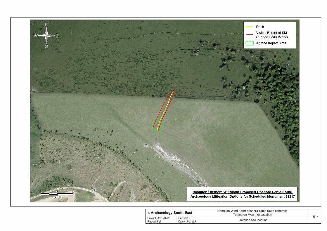
Fig. 2Project Ref: 7023 Feb 2015 Detailed site locationDrawn by: JLR
© Archaeology South-East
Report Ref:
Rampion Wind Farm offshore cable route scheme: Tottington Mount excavation