
Rampion Offshore Wind Farm - National Infrastructure … · Rampion Offshore Wind Farm ......
38
Rampion Offshore Wind Farm ES Section 23 – Surface Water, Hydrology & Flood Risk RSK Environmental Ltd Document 6.1.23 December 2012 APFP Regulation 5(2)(a) Revision A E.ON Climate & Renewables UK Rampion Offshore Wind Limited
Transcript of Rampion Offshore Wind Farm - National Infrastructure … · Rampion Offshore Wind Farm ......
Rampion Offshore Wind Farm
ES Section 23 – Surface Water, Hydrology &
Flood Risk
RSK Environmental Ltd Document 6.1.23
December 2012
APFP Regulation 5(2)(a)
Revision A
E.ON Climate & Renewables UK Rampion Offshore Wind Limited
E.ON Climate & Renewables Rampion Offshore Wind Farm
Environmental Statement
RSK Environment Ltd 23-i
RSK/HE/P41318/03/Section 23 – Surface Water, Hydrology and Flood Risk
CONTENTS
23 SURFACE WATER HYDROLOGY AND FLOOD RISK ......................................... 23-1
23.1 Introduction ....................................................................................................... 23-1
23.2 Legislation and Policy Context ........................................................................... 23-1
23.3 Assessment Methodology.................................................................................. 23-5
23.4 Baseline Conditions.......................................................................................... 23-11
23.5 Assessment of Impacts .................................................................................... 23-17
23.6 Mitigation Measures........................................................................................ 23-24
23.7 Residual Effects ................................................................................................ 23-31
23.8 Cumulative Impacts ......................................................................................... 23-31
23.9 References ....................................................................................................... 23-32
Tables
Table 23.1: Relevant Scoping Responses....................................................................... 23-6
Table 23.2: Receptor Sensitivity .................................................................................... 23-9
Table 23.3: Magnitude of Impact................................................................................. 23-10
Table 23.4: Significance of Residual Effects................................................................. 23-10
Table 23.5: WFD Water Bodies and Current Condition............................................... 23-12
Table 23.6: Peak Tide Levels for a Range of Annual Return Periods ........................... 23-14
Table 23.7: Summary of Impacts, Mitigation Measures and Significance of Effects .. 23-33
Figures
Figure 23.1: Flood Zones (2 parts)

E.ON Climate & Renewables Rampion Offshore Wind Farm
Environmental Statement
RSK Environment Ltd 23-1
RSK/HE/P41318/03/Section 23 – Surface Water, Hydrology and Flood Risk
23 SURFACE WATER HYDROLOGY AND FLOOD RISK
23.1 Introduction
23.1.1 This section of the Environmental Statement (ES) considers the water resources
and drainage conditions in relation to the proposed onshore cable route and
onshore substation for the Rampion Offshore Wind Farm (the Project), and
assesses factors such as flood risk, drainage design and water resource
management which will affect the proposed development in terms of its
sustainability, safety and integrity. This in turn will have direct and indirect
impacts on the environment.
23.1.2 A desk-based study of the hydrology and hydrogeology has been undertaken,
which includes watercourses, areas prone to flooding, aquifers, water
abstraction and discharge points.
23.2 Legislation and Policy Context
Key Legislation
23.2.1 The Water Resources Act 1991 and The Water Act 2003: The Water Resources
Act 1991 (the 1991 Act) sets out the relevant statutory regulatory controls that
provide protection water bodies and water resources. The 1991 Act was
modernised by the introduction of the Water Act 2003 (the 2003 Act). The 2003
Act governs the control of water abstraction, discharge to water bodies, water
impoundment, conservation and drought provision. The 2003 Act has changed
six key areas of the 1991 Act and of relevance to the proposed elements of the
Project is the need to obtain a licence for any dewatering for engineering works,
which was previously exempt.
23.2.2 Flood and Water Management Act 2010: This legislation was formally ratified in
April 2010 with the aim to implement the findings of the 2007 Pitt Review and
co-ordinate control of drainage and flood issues. There are a number of
increased responsibilities within the act that affect adoption of Sustainable
Drainage Systems (SuDS) features and the role of the Environment Agency to
expand on the mapping data they provide. The implementation of SuDS features
has many beneficial impacts on the treatment of surface water during
remediation works.
Rampion Offshore Wind Farm E.ON Climate & Renewables
Environmental Statement
23-2 RSK Environment Ltd
RSK/HE/P41318/03/ Section 23 – Surface Water, Hydrology and Flood Risk
23.2.3 The Water Framework Directive (WFD) 2000: The WFD which came into force in
2000; is the most substantial piece of EU water legislation to date. All new
activities in the water environment will need to consider the Directive. The WFD
was transposed into law in England and Wales by the Water Environment (Water
Framework Directive) (England and Wales) Regulations 2003. The WFD requires
that environmental objectives be set for all surface and ground waters in England
and Wales to enable them to achieve Good Status (or Good Ecological Potential
for Heavily Modified and Artificial Water Bodies) by a defined date. These
environmental objectives are listed below:
• Prevent deterioration in the status of aquatic ecosystems, protect them and
improve the ecological condition of waters;
• Aim to achieve at least good status for all water bodies by 2015. Where this is
not possible and subject to the criteria set out in the Directive, aim to achieve
good status by 2021 or 2027;
• Meet the requirements of Water Framework Directive Protected Areas;
• Promote sustainable use of water as a natural resource;
• Conserve habitats and species that depend directly on water;
• Progressively reduce or phase out the release of individual pollutants or
groups of pollutants that present a significant threat to the aquatic
environment; progressively reduce the pollution of groundwater and prevent
or limit the entry of pollutants; and
• Contribute to mitigating the effects of floods and droughts.
Other relevant legislation that has been taken into account includes the
following:
• Contaminated Land (England) Regulations 2006, SI 1380;
• Environmental Protection Act 1990;
• Environment Act 1995;
• Groundwater Regulations 1998;
• Environmental Permitting Regulations 2010 (as amended);
• Site Waste Management Plans Regulations 2008, SI 314;
• Environmental Protection (Duty of Care) Regulations 1991, SI 2839 (as
amended);
• Wildlife and Countryside Act 1981 (as amended); and
E.ON Climate & Renewables Rampion Offshore Wind Farm
Environmental Statement
RSK Environment Ltd 23-3
RSK/HE/P41318/03/Section 23 – Surface Water, Hydrology and Flood Risk
• Environmental Damage (Prevention and Remediation) Regulations 2009, SI
153.
National Policy Context
23.2.4 National Policy Statements (NPS) provide the primary basis on which the
Secretary of State is required to make its decisions. The specific assessment
requirements for geology, hydrogeology, land quality and flood risk, as detailed
within the NPSs, are set out below.
23.2.5 NPS EN-5 (Electricity Network Infrastructure) and EN-3 (Renewable Energy) do
not specifically consider geology, hydrogeology, land quality or flood risk
impacts. However, EN-1 (Overarching NPS for Energy) does include generic
requirements.
23.2.6 Paragraph 5.3.3 states that: “Where the development is subject to EIA the
applicant should ensure that the ES clearly sets out any effects on internationally,
nationally and locally designated sites of ecological or geological conservation
importance….”
23.2.7 Paragraph 5.14.6 states that: “The applicant should set out the arrangements
that are proposed for managing any waste produced and prepare a Site Waste
Management Plan. The arrangements described and Management Plan should
include information on the proposed waste recovery and disposal system for all
waste generated by the development, and an assessment of the impact of the
waste arising from development on the capacity of waste management facilities
to deal with other waste arising in the area for at least five years of operation.
The applicant should seek to minimise the volume of waste produced and the
volume of waste sent for disposal unless it can be demonstrated that this is the
best overall environmental outcome.”
23.2.8 Paragraph 5.15.2 states that: “Where the project is likely to have effects on the
water environment, the applicant should undertake an assessment of the existing
status of, and impacts of the proposed project on, water quality, water resources
and physical characteristics of the water environment as part of the ES or
equivalent.”
23.2.9 Paragraph 5.15.3 states that: “The ES should in particular describe:
• The existing quality of waters affected by the proposed project and the
impacts of the proposed project on water quality, noting any relevant existing
discharges, proposed new discharges and proposed changes to discharges.
• Existing water resources affected by the proposed project and the impacts of
the proposed project on water resources, noting any relevant existing
abstraction rates, proposed new abstraction rates and proposed changes to
abstraction rates (including any impact on or use of mains supplies and
reference to Catchment Abstraction Management Strategies).
Rampion Offshore Wind Farm E.ON Climate & Renewables
Environmental Statement
23-4 RSK Environment Ltd
RSK/HE/P41318/03/ Section 23 – Surface Water, Hydrology and Flood Risk
• Existing physical characteristics of the water environment (including quantity
and dynamics of flow) affected by the proposed project and any impact of
physical modifications to these characteristics.
• Any impacts of the proposed project on water bodies or protected areas
under the Water Framework Directive and source protection zones (SPZs)
around potable groundwater abstractions.”
23.2.10 Paragraph 5.7.4 states that: “Applications for energy projects of 1 hectare or
greater in Flood Zone 1 in England or Zone A in Wales and all proposals for
energy projects located in Flood Zones 2 and 3 should be accompanied by a flood
risk assessment (FRA).” Paragraph 5.7.6 also states that: “Further guidance can
be found in the Practice Guide which accompanies Planning Policy Statement 25
(PPS25)”.
National Planning Policy Framework
23.2.11 The assessment has been prepared in accordance with the National Planning
Policy Framework (NPPF) and its accompanying guidance document.
23.2.12 The NPPF sets out the criteria for development and flood risk by stating that
inappropriate development in areas at risk of flooding should be avoided by
directing development away from areas at highest risk, but where development
is necessary, making it safe without increasing flood risk elsewhere. The key
definitions (DCLG, 2012) are:
• “Areas at risk of flooding” means land within flood zones 2 and 3 or land
within flood zone 1 that has critical drainage problems and has been notified
to the local planning authority by the Environment Agency; and
• “Flood risk” means risk from all sources of flooding, including from rivers and
the sea, directly from rainfall on the ground surface and rising groundwater,
overwhelmed sewers and drainage systems, and from reservoirs, canals and
lakes and other artificial sources.
Pollution Prevention Guidance
23.2.13 The Environment Agency (EA) has published a number of Pollution Prevention
Guidelines (PPGs) many of which apply to the proposed onshore works. These
are:
• PPG 1: General guide to the prevention of water pollution;
• PPG 2: Above ground oil storage tanks;
• PPG 3: Use and design of oil separators in surface water drainage systems;
• PPG 4: Treatment and disposal of sewage where no mains drainage is
available;
E.ON Climate & Renewables Rampion Offshore Wind Farm
Environmental Statement
RSK Environment Ltd 23-5
RSK/HE/P41318/03/Section 23 – Surface Water, Hydrology and Flood Risk
• PPG 5: Works in, near or liable to affect watercourses;
• PPG 6: Working at construction and demolition sites;
• PPG 8: Safe storage and disposal of used oils;
• PPG13: Vehicle washing and cleaning;
• PPG 18: Managing fire water and major spillages;
• PPG 20: Dewatering of underground ducts and chambers;
• PPG 21: Pollution incident response planning;
• PPG 26: Drums and intermediate bulk containers;
• Pollution Prevention: Major cable routes;
• CIRIA guidelines: Control of Water Pollution from Linear Construction
Projects;
• CIRIA and Environment Agency joint guidelines: Masonry Bunds for Oil
Storage Tanks; and
• CIRIA and Environment Agency joint guidelines: Concrete Bunds for Oil
Storage Tanks.
23.3 Assessment Methodology
Establishment of Baseline Environment
23.3.1 Information on surface water and flood risk within an area of search comprising a
2km wide corridor around the proposed onshore works, including the onshore
cable route and the substation, was collected from the following sources:
• British Geological Survey (BGS) 1:50,000 scale geological mapping provided in
digital format (where available);
• Information from the Environment Agency and local authorities on
abstractions and discharges to watercourses;
• Hydrogeological maps;
• Groundwater vulnerability maps;
• Soil survey maps;
• Environment Agency water quality and discharge records;
Rampion Offshore Wind Farm E.ON Climate & Renewables
Environmental Statement
23-6 RSK Environment Ltd
RSK/HE/P41318/03/ Section 23 – Surface Water, Hydrology and Flood Risk
• Local Authority private water supply records; and
• Relevant publications including the Strategic Flood Risk Assessment (SFRA),
Catchment Management Plan (CMP), South West River Basin Management
Plan (RBMP) and Shoreline Management Plan 2 (SMP2).
23.3.2 In addition, site visits to specific locations along the cable route and substation
site were undertaken by an RSK hydrologist in June and October 2011, and
discussions were held with the Environment Agency (Solent and South Downs
Area).
Scoping
23.3.3 As part of the scoping phase of the Environmental Impact Assessment (EIA), a
Scoping Report (E.ON/RSK, September 2010) was prepared to set out the
proposed approach to EIA in respect of the proposed development, including the
identification of assessment methodologies for each of the EIA topic areas to be
assessed. The Scoping Report was submitted to the Infrastructure Planning
Commission (IPC) in September 2010. A Scoping Opinion (IPC, October 2010) was
received from the IPC in October 2010 incorporating comments from a wide
range of consultees. A copy of the Scoping Report and Scoping Opinion including
consultee comments are included in Appendix 5.1 and 5.2.
23.3.4 The information and advice received during the scoping process with regard to
hydrology and flood risk is summarised in Table 23.1.
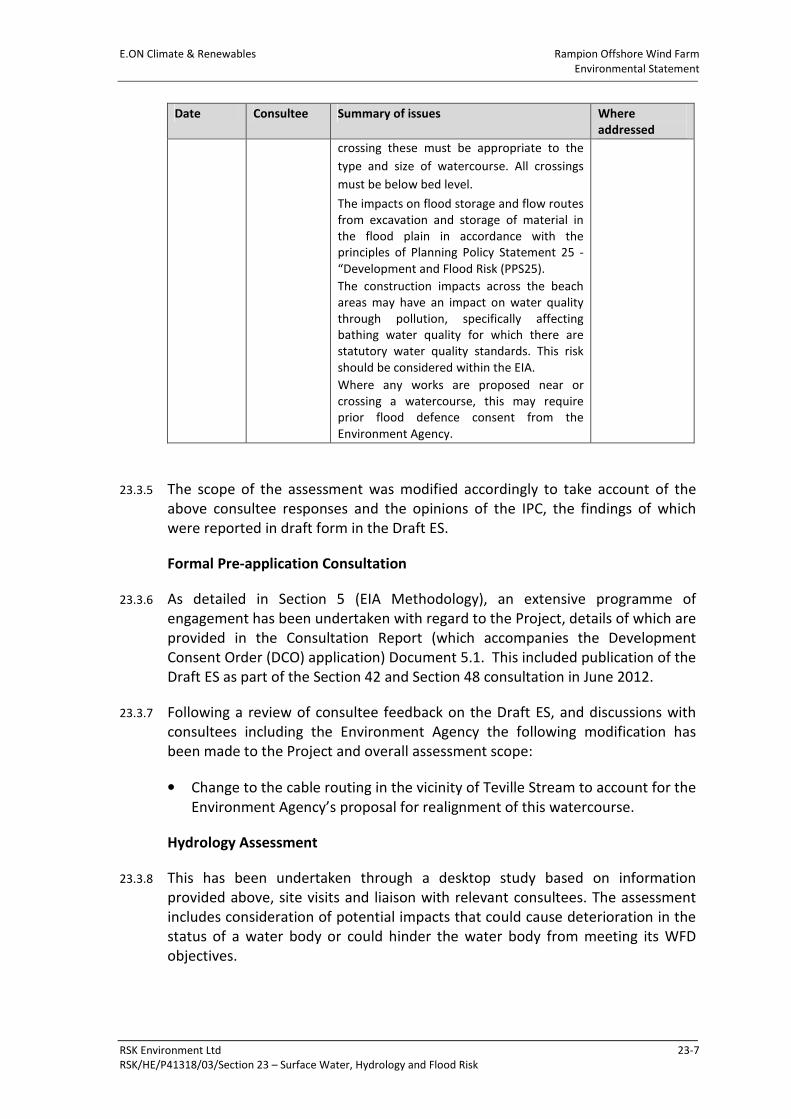
Table 23.1: Relevant Scoping Responses
Date Consultee Summary of issues Where
addressed
11/10/2010
and
12/10/2010
Adur District
Council
Adur District Council’s Strategic Flood Risk
Assessment should be used for Adur District,
not Environment Agency info.
Flood Risk
Assessment.
Paragraphs
23.3.1
08/10/2010 Environment
Agency
We would expect the following to be
included in the assessment methodology:
The Shoreham to Lancing Sea Defences fall
under the jurisdiction of the Environment
Agency. Under the Water Resources Act
1991 the integrity of these defences must be
ensured.
All watercourses along the proposed route
must be identified, including ditches and
drains.
Several of these watercourses have status
under the Water Framework Directive
(WFD). It will be necessary to demonstrate
how this development will contribute to the
delivery of WFD actions on impacted water
bodies.
A number of main rivers will be crossed,
including the tidal Adur. The method of
Flood Risk
Assessment,
Paragraphs
23.4, 23.5.4-
23.5.5
E.ON Climate & Renewables Rampion Offshore Wind Farm
Environmental Statement
RSK Environment Ltd 23-7
RSK/HE/P41318/03/Section 23 – Surface Water, Hydrology and Flood Risk
Date Consultee Summary of issues Where
addressed
crossing these must be appropriate to the
type and size of watercourse. All crossings
must be below bed level.
The impacts on flood storage and flow routes
from excavation and storage of material in
the flood plain in accordance with the
principles of Planning Policy Statement 25 -
“Development and Flood Risk (PPS25).
The construction impacts across the beach
areas may have an impact on water quality
through pollution, specifically affecting
bathing water quality for which there are
statutory water quality standards. This risk
should be considered within the EIA.
Where any works are proposed near or
crossing a watercourse, this may require
prior flood defence consent from the
Environment Agency.
23.3.5 The scope of the assessment was modified accordingly to take account of the
above consultee responses and the opinions of the IPC, the findings of which
were reported in draft form in the Draft ES.
Formal Pre-application Consultation
23.3.6 As detailed in Section 5 (EIA Methodology), an extensive programme of
engagement has been undertaken with regard to the Project, details of which are
provided in the Consultation Report (which accompanies the Development
Consent Order (DCO) application) Document 5.1. This included publication of the
Draft ES as part of the Section 42 and Section 48 consultation in June 2012.
23.3.7 Following a review of consultee feedback on the Draft ES, and discussions with
consultees including the Environment Agency the following modification has
been made to the Project and overall assessment scope:
• Change to the cable routing in the vicinity of Teville Stream to account for the
Environment Agency’s proposal for realignment of this watercourse.
Hydrology Assessment
23.3.8 This has been undertaken through a desktop study based on information
provided above, site visits and liaison with relevant consultees. The assessment
includes consideration of potential impacts that could cause deterioration in the
status of a water body or could hinder the water body from meeting its WFD
objectives.
Rampion Offshore Wind Farm E.ON Climate & Renewables
Environmental Statement
23-8 RSK Environment Ltd
RSK/HE/P41318/03/ Section 23 – Surface Water, Hydrology and Flood Risk
23.3.9 For the purpose of the WFD assessment the EA RBMP has been used. The aim of
this process is to determine whether the proposed onshore works could have an
impact upon the water quality criteria for the water bodies located within the
area of search (see section 24 Ecology, paragraph 24.3.6).
Flood Risk Assessment
23.3.10 RSK was commissioned to undertake a FRA of the proposed onshore cable route
and substation site (see Appendix 23.1 and 23.2).
23.3.11 Although revoked and replaced with the NPPF, the FRA has been prepared in
accordance with PPS25: Development and Flood Risk and the Interim Code of
Practice for Sustainable Drainage Systems (DEFRA, 2004).
23.3.12 The publication of the NPPF has revoked PPS25 amongst others as of 27 March
2012. The Technical Guidance to the National Planning Policy Framework (DCLG,
2012) includes flood risk guidance and retains key elements of PPS25 including
the Sequential and Exception Tests, climate change allowances and development
classifications. The information contained in this new technical guidance along
with the NPPF when combined with guidance contained in the Communities and
Local Government’s Planning Policy Statement 25: Development and Flood Risk
Practice Guide (DCLG, 2010) and the British Standard ‘BS 8533:2011 Assessing
and managing flood risk in development. Code of practice’ has formed the basis
of the FRA.
23.3.13 The FRA has considered the effects of the proposed onshore cable route on the
identified potential flood areas in the immediate locality. The FRA for the
proposed substation site has been undertaken to:
• Determine the extent of new flooding provision and the influence on the site;
• Review the surface water drainage based upon the proposed layouts, and to
determine the extent of infrastructure required; and
• Assess the impact on the onshore works from global warming and anticipated
increases in rainfall over the lifetime of the development.
Identification and Assessment of Impacts and Mitigation Measures
23.3.14 Potential impacts have been identified from data gathered during the desk study.
This data has been assessed with the knowledge and experience of the impacts
from similar construction projects, leading to the development of appropriate
mitigation measures.
E.ON Climate & Renewables Rampion Offshore Wind Farm
Environmental Statement
RSK Environment Ltd 23-9
RSK/HE/P41318/03/Section 23 – Surface Water, Hydrology and Flood Risk
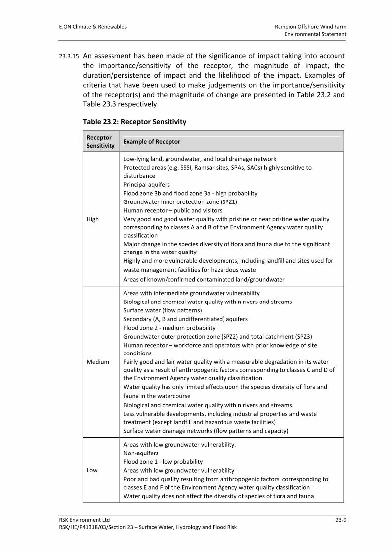
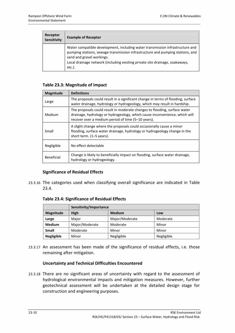
23.3.15 An assessment has been made of the significance of impact taking into account
the importance/sensitivity of the receptor, the magnitude of impact, the
duration/persistence of impact and the likelihood of the impact. Examples of
criteria that have been used to make judgements on the importance/sensitivity
of the receptor(s) and the magnitude of change are presented in Table 23.2 and
Table 23.3 respectively.
Table 23.2: Receptor Sensitivity
Receptor
Sensitivity Example of Receptor
High
Low-lying land, groundwater, and local drainage network
Protected areas (e.g. SSSI, Ramsar sites, SPAs, SACs) highly sensitive to
disturbance
Principal aquifers
Flood zone 3b and flood zone 3a - high probability
Groundwater inner protection zone (SPZ1)
Human receptor – public and visitors
Very good and good water quality with pristine or near pristine water quality
corresponding to classes A and B of the Environment Agency water quality
classification
Major change in the species diversity of flora and fauna due to the significant
change in the water quality
Highly and more vulnerable developments, including landfill and sites used for
waste management facilities for hazardous waste
Areas of known/confirmed contaminated land/groundwater
Medium
Areas with intermediate groundwater vulnerability
Biological and chemical water quality within rivers and streams
Surface water (flow patterns)
Secondary (A, B and undifferentiated) aquifers
Flood zone 2 - medium probability
Groundwater outer protection zone (SPZ2) and total catchment (SPZ3)
Human receptor – workforce and operators with prior knowledge of site
conditions
Fairly good and fair water quality with a measurable degradation in its water
quality as a result of anthropogenic factors corresponding to classes C and D of
the Environment Agency water quality classification
Water quality has only limited effects upon the species diversity of flora and
fauna in the watercourse
Biological and chemical water quality within rivers and streams.
Less vulnerable developments, including industrial properties and waste
treatment (except landfill and hazardous waste facilities)
Surface water drainage networks (flow patterns and capacity)
Low
Areas with low groundwater vulnerability.
Non-aquifers
Flood zone 1 - low probability
Areas with low groundwater vulnerability
Poor and bad quality resulting from anthropogenic factors, corresponding to
classes E and F of the Environment Agency water quality classification
Water quality does not affect the diversity of species of flora and fauna
Rampion Offshore Wind Farm E.ON Climate & Renewables
Environmental Statement
23-10 RSK Environment Ltd
RSK/HE/P41318/03/ Section 23 – Surface Water, Hydrology and Flood Risk
Receptor
Sensitivity Example of Receptor
Water compatible development, including water transmission infrastructure and
pumping stations, sewage transmission infrastructure and pumping stations, and
sand and gravel workings.
Local drainage network (including existing private site drainage, soakaways,
etc.).
Table 23.3: Magnitude of Impact
Magnitude Definitions
Large The proposals could result in a significant change in terms of flooding, surface
water drainage, hydrology or hydrogeology, which may result in hardship.
Medium
The proposals could result in moderate changes to flooding, surface water
drainage, hydrology or hydrogeology, which cause inconvenience, which will
recover over a medium period of time (5–10 years).
Small
A slight change where the proposals could occasionally cause a minor
flooding, surface water drainage, hydrology or hydrogeology change in the
short term. (1–5 years).
Negligible No effect detectable
Beneficial Change is likely to beneficially impact on flooding, surface water drainage,
hydrology or hydrogeology.
Significance of Residual Effects
23.3.16 The categories used when classifying overall significance are indicated in Table
23.4.
Table 23.4: Significance of Residual Effects
Sensitivity/Importance
Magnitude High Medium Low
Large Major Major/Moderate Moderate
Medium Major/Moderate Moderate Minor
Small Moderate Minor Minor
Negligible Minor Negligible Negligible
23.3.17 An assessment has been made of the significance of residual effects, i.e. those
remaining after mitigation.
Uncertainty and Technical Difficulties Encountered
23.3.18 There are no significant areas of uncertainty with regard to the assessment of
hydrological environmental impacts and mitigation measures. However, further
geotechnical assessment will be undertaken at the detailed design stage for
construction and engineering purposes.
E.ON Climate & Renewables Rampion Offshore Wind Farm
Environmental Statement
RSK Environment Ltd 23-11
RSK/HE/P41318/03/Section 23 – Surface Water, Hydrology and Flood Risk
23.4 Baseline Conditions
Hydrology – Cable Route
23.4.1 The watercourses within the area of search include the main River Adur and its
tributaries, which drain the Low Weald area through the South Downs, flowing
out to sea at Shoreham, and the Teville Stream (designated as a main river)
which drains the coastal area to the west of the River Adur.
23.4.2 The River Adur and its tributaries are situated in the High Weald, Low Weald and
South Downs natural conservation areas (as defined by Natural England). The
catchment is largely rural with a few urban centres such as Horsham and the
urbanised coastal strip of Brighton and Hove, Shoreham and Worthing. The
entire catchment of the River Adur is in excess of 600km2 and extends from the
south coast at Littlehampton in the west, Brighton and Hove in the east,
northwards to Horsham and Haywards Heath. The upper and western branch of
the Adur catchment spans most of Horsham and is underlain by the Weald Clay.
As a result, the watercourses respond rapidly to rainfall causing the water to run-
off the impermeable surface. There is, however, little history of flooding in this
sub-catchment of the Adur and consequently there is a low risk to people and
property in this area. This differs from the lower, more permeable chalk areas,
which respond more slowly and can be a source of groundwater flooding from
the chalk aquifers. Flooding can occur from a number of sources such as rivers
overtopping their defences (fluvial flooding), urban surface water run-off and
inadequate local drainage, run-off from fields and groundwater flooding as well
as a mixture of tidal and fluvial flooding.
23.4.3 The River Adur to the south of Upper Beeding includes part of the Adur Estuary
Site of Special Scientific Interest (SSSI) and consists of relatively flat low-lying
ground in a valley between the South Downs. The defences along this stretch of
river will not generally overtop unless the fluvial flooding is influenced by the
tidal conditions.
23.4.4 The Teville Stream rises at allotments in Tarring, before flowing alongside Tarring
Road and Teville Road for much of its length. Passing through Homefield Park
and the playing fields of Davison High School, the stream continues into fields
near East Worthing railway station, it meets with Broadwater Brook (also known
as Sompting Brook) before turning abruptly southwards to Brooklands Lake, from
where it flows into the English Channel. The Teville Stream forms a shallow
valley, so land to the south of the stream rises, reaching a high point along the
line of the A259 before falling again to the south, towards the sea where a flood
storage lake is situated.
23.4.5 The Environment Agency also administers the internal drainage boards (IDB) to
the south of the Horsham DC boundary along the River Arun and the River Adur.
Rampion Offshore Wind Farm E.ON Climate & Renewables
Environmental Statement
23-12 RSK Environment Ltd
RSK/HE/P41318/03/ Section 23 – Surface Water, Hydrology and Flood Risk
Water Framework Directive
23.4.6 The South East River Basin Management Plan and the Environment Agency’s
web-based ‘Flood Map’ were used to determine which water bodies could be
potentially affected by the proposed onshore works. The names, ID numbers,
designation, status classification and objectives for all relevant water bodies
were obtained from Annex B of the RBMP.
23.4.7 The water bodies listed in Table 23.5 have been identified within the study area
(data extracted from the South East RBMP).
Table 23.5: WFD Water Bodies and Current Condition
Water Body Current Status Status Objective
Herrings Stream Poor Good by 2027
Woodsmill Stream Moderate Good by 2027
Hammer Stream Moderate Good by 2027
River Arun Moderate Good by 2027
Teville Stream Bad Good by 2027
Egerton Park Stream Moderate Good by 2027
Langley Sewer Moderate Good by 2027
23.4.8 As indicated in Table 23.5, under the WFD the Teville Stream has been
designated as ‘bad’ ecological status and has numerous urban pressures. The
WFD sets out structured mitigation measures to achieve good ecological
potential. The Environment Agency is currently undertaking a project (Teville
Stream Restoration) that investigates engineering options for improving Teville
Stream.
Hydrology – Substation Site
23.4.9 The within a study area of 500m surrounding the proposed substation site
contains a number of surface water features including approximately 23 surface
water lagoons, possibly associated with water retention for irrigation purposes.
23.4.10 Within the site a small drainage ditch runs parallel to an existing north south
hedge line. This ditch takes run off from the surrounding fields (see Target Note
278/271 in Appendix 24.11- referenced as a dry ditch).
E.ON Climate & Renewables Rampion Offshore Wind Farm
Environmental Statement
RSK Environment Ltd 23-13
RSK/HE/P41318/03/Section 23 – Surface Water, Hydrology and Flood Risk
Geology
23.4.11 A description of the geology along the proposed cable route is presented in
Sections 22.4.7–22.4.19 and is summarised here. The solid geology beneath the
first 2km from the landfall of the route comprises silty clay of the Woolwich and
Reading Beds; this section of the route is also the most developed with
commercial, industrial and public open space found alongside. These rocks
typically have a lower infiltration rate, greater surface flow and intermediate
sensitivity.
23.4.12 The underlying Chalk geology, which is found throughout much of West Sussex,
underlies the majority of the proposed route (from 1.4km to 15.0km). These are
overlain by generally shallow and well-drained chalk or lime dominated top soils
that are often very shallow and can sustain little vegetation. Rain can easily
infiltrate this geology through large fissures into the underlying chalk aquifers,
which then emerges along a scarp-slope spring line further downstream towards
the lower reaches of the River Adur.
23.4.13 The lower reaches of the River Adur catchment is underlain mainly by Chalk.
Groundwater from the Chalk is likely to discharge into the river as base-flow at a
relatively constant rate throughout the year. However, when groundwater levels
rise groundwater flooding can occur, particularly in the broad chalk valleys. The
upper reaches of the River Adur are underlain by silty mudstone of the Weald
Clay, which retards infiltration and is further characterised by standing surface
water features and higher rates of surface flow at times of heavy rainfall.
Consequently, river flow rates in these geological settings can be influenced by
precipitation and can be characterised by a greater range of flow conditions.
Flood Risk – Cable Route
23.4.14 The EA has available on their website flood zone maps for much of England and
Wales. The latest EA flood zone map (Figure 23.1) indicates that the proposed
cable route for the Project will cross all flood zone types.
23.4.15 Flooding from rivers occurs when water levels rise higher than bank levels,
causing floodwater to spill across adjacent land (flood plain). The main reasons
that water levels can rise in rivers are:
• Intense or prolonged rainfall causing run-off rates and flow to increase in
rivers, exceeding the capacity the channel. This can be exacerbated by wet
antecedent conditions and where there are significant contributions of
groundwater;
• Constrictions in the river channel causing flood water to backup;
• Blockage of structures or the river channel causing flood water to backup;
and
Rampion Offshore Wind Farm E.ON Climate & Renewables
Environmental Statement
23-14 RSK Environment Ltd
RSK/HE/P41318/03/ Section 23 – Surface Water, Hydrology and Flood Risk
• High water levels and/or locked flood (tide) gates preventing discharge at the
outlet of the river.
23.4.16 The proposed cable route will inevitably cross a number of watercourses and
associated flood plains. As a result, the route will be located in all flood zone
types over its course (Figure 23.1).
23.4.17 Flooding from the sea occurs when water levels in the sea rise above ground
levels of coastal land. This can occur:
• During normal high tides, where land floods on a regular basis;
• When there are extreme atmospheric effects such as storm surges and
tsunamis; and
• When wind action causes water levels of the sea to rise.
23.4.18 Flooding from the sea is a natural and regular occurrence in estuarine
environments and coastal marshlands. All low-lying ground along the coastline of
West Sussex is at risk. Where development has encroached on the coastal flood
plain, flood defences have been constructed to prevent flooding from the sea.
23.4.19 The onset of flooding from the sea can be extremely rapid. Deep, fast-flowing
floodwater can be extremely hazardous. The severity of flooding will depend on
tide levels, wind and wave conditions and topography. The Environment Agency
has provided tide levels for a range of return periods as presented in Table 23.6.
23.4.20 The coastline of West Sussex is heavily populated and sea defences mostly
protect the area of low-lying land, which is at risk of flooding. However, these
defences can be overtopped or can breach, which can cause extensive flooding
of the land with significant flood depths and high velocities. Flooding from sea is
hazardous to life, property and the environment. Significant rebuild is required
after severe flood events. Flooding from sea can also last a long time in areas
where gravity drainage to the sea is hindered by flood defences.
Table 23.6: Peak Tide Levels for a Range of Annual Return Periods
Annual Exceedance Probability (%) Shoreham (m AOD*) Brighton (m AOD*)
10 3.94 4.10
2 4.14 4.30
1 4.22 4.40
0.5 4.30 4.50
* AOD: Above Ordnance Datum
E.ON Climate & Renewables Rampion Offshore Wind Farm
Environmental Statement
RSK Environment Ltd 23-15
RSK/HE/P41318/03/Section 23 – Surface Water, Hydrology and Flood Risk
23.4.21 Flooding from land occurs when intense, often short duration rainfall is unable to
soak into the ground or enter drainage systems. It is made worse when soils are
saturated so that they cannot accept any more water. The excess water then
ponds in low points, overflows or concentrates in minor drainage lines that are
usually dry. This type of flooding is usually short-lived and associated with heavy
downpours of rain. Often there is limited warning before this type of localised
flooding occurs. Surface water run-off can cause localised flooding in natural
valleys as normally dry areas become inundated and in natural low spots where
water may collect.
23.4.22 Drainage basins or catchments vary in size and shape, which has a direct effect
on the amount of surface run-off. The amount of run-off is also a function of
geology, slope, climate, rainfall, saturation, soil type and vegetation. Geological
considerations include rock and soil types and characteristics, as well as degree
of weathering. Porous material (sand, gravel, and soluble rock) absorbs water
more readily than fine-grained, dense clay or unfractured rock and has a lower
run-off potential. Poorly drained material has a higher run-off potential and is
more likely to cause flooding.
23.4.23 Flooding from sewers occurs when rainfall exceeds the capacity of networks or
when there is an infrastructure failure.
23.4.24 Groundwater flooding is caused by the natural emergence at the ground surface
of water originating from underlying permeable sediments or rocks (aquifers).
The groundwater may emerge as one or more point discharges (springs) or as
diffuse discharge/seepage over an extended area. Groundwater flooding tends to
be more persistent than other sources of flooding, typically lasting for weeks or
months rather than for hours or days.
23.4.25 Groundwater flooding does not generally pose a significant risk to life owing to
the slow rate at which the water level rises; however, it can cause significant
damage to property, especially in urban areas.
23.4.26 The EA has recently published flood risk mapping as a result of potential failure
of reservoirs. This map shows that the Project site is not in an area at risk of
flooding from this source. There are no other known structures in the vicinity of
the Project site that could pose a flood risk to the cable route or the substation.
Flood Defences
23.4.27 A number of flood defences are present within the area of search (2km around
the route). The main river flood defences in West Sussex typically consist of:
• Raised barriers such as walls or embankments;
• Online storage areas, which act to reduce flood peaks by attenuating flood
waters prior to discharge back into the river network;
Rampion Offshore Wind Farm E.ON Climate & Renewables
Environmental Statement
23-16 RSK Environment Ltd
RSK/HE/P41318/03/ Section 23 – Surface Water, Hydrology and Flood Risk
• Diversion of flows from high risk areas, or increasing channel capacity to carry
greater flow through high risk areas (e.g. widening, deepening and
straightening of channels); and/or
• Other structures that modify the natural flow of rivers, including weirs,
sluices, culverts and bridge crossings, and bank protection works.
23.4.28 The main raised defence structures in West Sussex are earth embankments that
run along the Adur and Arun rivers. The embankments run along the middle and
lower reaches and protect against river and sea flooding. On the Adur there are
secondary defences known as counterbanks, which are at right angles to the
river. The purpose of this is to restrict flooding to a smaller, more confined area if
the raised flood embankments are overtopped. There are also several small earth
embankments around Selsey.
23.4.29 The Environment Agency and local planning authorities carry out annual
inspections of flood defence assets and update National Flood and Coastal
Defence Database (NFCDD). The data from these inspections is used to inform
the owner of their duty to maintain assets to an appropriate level.
23.4.30 The management of the river and coastal defences and assets within West
Sussex is divided between several different parties. The Environment Agency is
responsible for the majority of the tidal and river defences and has a supervisory
duty over all flood defences given under the Environment Act 1995.
23.4.31 The coastal frontage between Sea Lane, Ferring and Western Road, Lancing is
managed by Worthing Borough Council under its permissive powers as the Coast
Protection Authority given by the Coast Protection Act 1949. This excludes the
coastline between Ferring, Sea Lane and the Borough Boundary (approx. 250m)
for which the Council is only the landowner.
23.4.32 The proposed cable route crosses the following flood defences:
• Coastal sea defences (groynes) at the landfall; and
• Earth embankments that run along the River Adur.
Flood Risk – Substation Site
23.4.33 The Environment Agency has produced flood zone maps for much of England and
Wales. The latest flood zone map shows the flood risk to the substation site is
low, being located within flood zone 1.
23.4.34 Given the rural nature of the substation location, it is unlikely that there are any
adopted sewer infrastructure serving the site; therefore, any new sewerage
infrastructure will be installed in line with current best practice. Flooding at the
site from this source is considered low.
E.ON Climate & Renewables Rampion Offshore Wind Farm
Environmental Statement
RSK Environment Ltd 23-17
RSK/HE/P41318/03/Section 23 – Surface Water, Hydrology and Flood Risk
23.4.35 Groundwater flooding is caused by the natural emergence at the ground surface
of water originating from underlying permeable sediments or rocks (aquifers).
The groundwater may emerge as one or more point discharges (springs) or as
diffuse discharge/seepage over an extended area. Groundwater flooding tends to
be more persistent than other sources of flooding, typically lasting for weeks or
months rather than for hours or days. Groundwater flooding does not generally
pose a significant risk to life owing to the slow rate at which the water level rises;
however, it can cause significant damage to property, especially in urban areas.
The soils around the Project’s substation site are generally impermeable and
therefore largely unresponsive to groundwater levels because of low infiltration.
Owing to the type of development proposed, it is not thought that groundwater
flooding will impact on the operations at the site.
23.4.36 If intense rain is unable to soak into the ground or be carried through man-made
drainage systems, for a variety of reasons, it can run-off over the surface causing
localised floods before reaching a river or other watercourse. Excess surface
water flows from the site are believed to drain naturally to the local water
features, either by overland flow or through infiltration. Flooding from this
source is considered low and will be considered within the layout of the site by
ensuring sensitive equipment is not located within a low spot on the site; this
should ensure the development is not at increased risk. Flooding of the site from
this source is considered low.
23.4.37 A number of small ponded areas have been identified from the Ordnance Survey
(OS) mapping, and following a walkover of the site and surrounding area it has
been confirmed that all these water bodies are retained below the surrounding
ground levels and are not retained by embankment. Therefore flooding from
these water bodies is considered low. There are no other potential sources of
flood risk known to the site.
23.4.38 The substation will be designed with reference to the potential impacts of
climate change. This will include incorporating the increase in rainfall over the
lifetime of the Project when designing the surface-water management system.
23.5 Assessment of Impacts
Rochdale Envelope Principles
23.5.1 In line with the use of the “Rochdale Envelope” (see Section 5 – EIA
Methodology), the assessment in this section has been based on a development
scenario, which is considered to be the worst case in terms of impacts to surface
water hydrology and flood risk. Rochdale Envelope principles relating to impacts
on surface water hydrology and flood risk relate primarily to the area of
temporary and permanent land take.
Rampion Offshore Wind Farm E.ON Climate & Renewables
Environmental Statement
23-18 RSK Environment Ltd
RSK/HE/P41318/03/ Section 23 – Surface Water, Hydrology and Flood Risk
23.5.2 Installation of the cable will require a working width no wider than 30m (except
at the locations where Horizontal Directional Drilling (HDD) is proposed),
comprising 15m for the cable easement and 15m for additional areas for storage
of excavated material and access along the cable trench. The cable easement will
not necessarily be central to the working width. Therefore, the Development
Boundary generally encompasses a working width of 40m along the cable route.
A 40m working width been taken to represent the worst case scenario for the
cable route assessment undertaken below.
23.5.3 The substation site covers an area of approximately 23.3 hectares.
Approximately 7.01 hectares will be required for the permanent footprint of the
substation, with the remainder required for site establishment, the temporary
construction road, lay down areas and landscaping. For the assessment
undertaken below, permanent land take of 7.01 hectares has been adopted as
the worst case scenario.
Construction – Cable Route
Hydrology
23.5.4 The watercourses along the onshore cable route mainly comprise field drains and
ditches. These will be diverted and reinstated on completion of the cable
installation works.
23.5.5 Apart from the River Adur crossing identified for HDD, the default crossing
method of watercourses will be trenching, but mini-HDD may also be employed
in certain cases. Open-cut trenching through watercourses could potentially
result in hydrological changes, including possible disturbance and modification to
flows, and potential impacts to water users. The banks and beds of watercourses
are also potentially at risk of physical damage.
23.5.6 The onshore cable route generally passes through agricultural land and,
therefore, a potential impact on surface waters may arise from silt discharged
from the working width during sudden rainfall events mobilising silt and
materials. Suspended solids produced during construction can potentially
produce adverse effects on aquatic ecology. In particular, suspended solids may
have an effect on:
• The survival of fish eggs in gravel beds or spawning grounds as a result of
deoxygenation caused by silt deposition;
• The survival of plants and algae by smothering;
• The survival of young fish and aquatic invertebrates such as dragonflies
through gill damage from sediment particles;
• The success of angling owing to increased turbidity; and
• Amenity value through impaired visual appearance.
E.ON Climate & Renewables Rampion Offshore Wind Farm
Environmental Statement
RSK Environment Ltd 23-19
RSK/HE/P41318/03/Section 23 – Surface Water, Hydrology and Flood Risk
23.5.7 Other potential impacts to surface waters include:
• Risk of accidental spillages from oil and fuel storage facilities as well as
construction materials; and
• Risk of adverse impacts to surface water quality as a result of the
mobilisation of existing contaminants.
23.5.8 There is potential for the cable trenches to act as drainage channels for surface
water run-off or lead to the drainage of the near surface water table water.
Where trenches are constructed on slopes the flow of water could potentially
lead to the erosion of soils, which could enter watercourses. These potential
effects would be particularly noticeable during wet weather periods.
23.5.9 The EA will be consulted during the detailed design phase to determine the most
appropriate method for each crossing and the appropriate method statements
will be prepared. A number of factors will affect the choice of crossing method,
including depth of water, available space, duration of works, bed conditions,
accessibility and potential ingress of water. Working widths are to be reduced to
20m at specific watercourse crossings (as listed in Section 2b Project Description
(Onshore), Table 2b.1) where potential risk to stream ecology has been
identified.
23.5.10 Potential impacts to surface waters as a result of HDD of watercourse crossings
include risk of adverse impacts to surface water quality arising from the break-
out of drilling muds.
23.5.11 HDD will also be used to cross the railway in the vicinity of the Teville Stream.
The HDD drill pit will be located to the east of the proposed realignment for the
Teville Stream thereby avoiding any impact on the realigned channel.
Water Quality
23.5.12 During onshore construction, the greatest risk will be when works in progress
expose areas of bare ground or soils. Sudden rainfall events can mobilise silt and
materials held within the site and, if not controlled, these will be conveyed to the
surrounding area. To a lesser degree, there is a potential risk of accidental
spillages.
Geology
23.5.13 Potential impacts common to all cable route construction works are outlined
below:
• Risk of pollution to groundwater from fuel and chemical spills;
• Risk of pollution to groundwater from the mobilisation of existing
contaminants;
Rampion Offshore Wind Farm E.ON Climate & Renewables
Environmental Statement
23-20 RSK Environment Ltd
RSK/HE/P41318/03/ Section 23 – Surface Water, Hydrology and Flood Risk
• The cable trench creating a preferential pathway for the migration of
groundwater and any contaminants contained within the groundwater;
• Dewatering activities for earthworks, excavations and HDD, which may
impact surface watercourse flows fed by groundwater, and cause the
drawing in of mobile contaminants from off-route sources; and
• Disruption of buried field drainage systems.
Flood Defences
23.5.14 The cable route will be constructed beneath the coastal sea defences using an
HDD technique, as described in Section 2b (Project Description (Onshore)).
Similarly, the River Adur flood defences will also be crossed using HDD. As a
result, no potential impacts are expected on the coastal defences.
Climate Change
23.5.15 The cable route will be designed with reference to the potential impacts of
climate change. This will include designing the cable route to take account of
potential shoreline re-alignment and future coastal inundation plans, and
ensuring that water stops are inserted in the trench to prevent the cable route
acting as a conduit for groundwater.
Construction – Substation Site
23.5.16 Construction impacts are considered to occur as a consequence of the actual
development (preliminary earthworks and construction operations) itself, and
are all considered as being potentially adverse in nature. The following
potentially significant impacts are typically associated with construction works
and are considered relevant to the proposed onshore substation development:
• Site drainage;
• Surface water outfalls;
• Siltation;
• Storage and handling of materials / oils / chemicals;
• Delivery / storage of construction materials;
• Concrete mixing; and
• Cross-contamination of geological strata due to piling.
E.ON Climate & Renewables Rampion Offshore Wind Farm
Environmental Statement
RSK Environment Ltd 23-21
RSK/HE/P41318/03/Section 23 – Surface Water, Hydrology and Flood Risk
23.5.17 During construction, the greatest risk will be when construction works are being
undertaken prior to completion of the proposed drainage system at the onshore
substation site. Sudden rainfall events can mobilise silts and materials held
within the site.
23.5.18 To a lesser degree the potential risk of accidental spillages from oil and fuel
storage facilities as well as construction materials would be present on site.
Cement, if leached into drainage ditches, water bodies or watercourses, would
potentially have detrimental effects by drawing oxygen from the water altering
the pH of the water. If these effects occur prior to the construction of the
drainage network then direct discharge to the watercourse, drainage ditch,
water bodies or groundwater may be a consequence.
Hydrology
23.5.19 Potential longer term impacts of the Project are considered to occur both as a
consequence of changes to the onshore substation site’s character and also
future use of the development.
23.5.20 The following impacts are likely to be associated with the substation
development:
• Run-off from roads, parking areas and other exposed processing areas
potentially containing elevated levels of hydrocarbons (oils) and heavy
metals;
• Increase in surface run-off from site leading to overloading of local drainage
infrastructure during intense rainstorms;
• Development of the site should not affect the surrounding surface water
features owing to the lack of hydraulic connectivity;
• Ditch diversions or culverting may be required to allow development of the
substation; and
• The development will not affect the existing flooding regime, subject to
suitable provision of drainage infrastructure on the site.
Water Quality
23.5.21 During onshore construction, the greatest risk will be when works in progress
expose areas of bare ground or soils. Sudden rainfall events can mobilise silt and
materials held within the site and, if not controlled, these will be conveyed to the
surrounding area. To a lesser degree, there is a potential risk of accidental
spillages of construction materials. Cement, if leached into surface-water
features, could have detrimental effects by drawing oxygen from the water and
altering the pH of the water. However, much of the works will be carried out
below the level of the surrounding ground, thus any surface water run-off will be
retained on site and will drain to the existing sewer network.
Rampion Offshore Wind Farm E.ON Climate & Renewables
Environmental Statement
23-22 RSK Environment Ltd
RSK/HE/P41318/03/ Section 23 – Surface Water, Hydrology and Flood Risk
Operation – Cable Route
23.5.22 There are no planned maintenance activities that will impact on water resources
during the operation of the onshore cable. Once constructed the cable route will
not impede existing flood flow routes or impact on the volumetric attenuation of
functional flood plains.
Operation – Substation Site
23.5.23 It is intended that surface water run-off from the proposed development once
constructed will be discharged to groundwater through infiltration techniques or
off-site at a controlled rate designed to closely mimic the existing situation.
23.5.24 Both the latest Sustainable Urban Drainage systems (SUDs) guidance and the
Environment Agency recommend that SUDS, in whole or part, should be
considered for all new development sites. It is therefore proposed to incorporate
SUDs into the development and this can be a combination of both physical
structures and techniques used to control surface water run-off as close to its
origin as possible.
23.5.25 A wide variety of sustainable drainage options are available that can be applied
in different ways to help manage both surface and groundwater in a sustainable
manner. Specific solutions need to be developed for each site individually, the
choice of which will depend on factors such as the nature of the site, the type of
pollutants present and the hydrology of the area – the substation site is not
located within a groundwater source protection zone.
23.5.26 The effectiveness of infiltration-based SUDs depends on the ‘infiltration
potential’ of the soil, protection of such systems from siltation and avoidance of
compaction of the ground during construction. There are currently no points of
discharge off the substation site and it is assumed that any rainfall on the site
either infiltrates into the soils or ponds on the surface. The proposed
development will increase the impermeable area on the site and therefore
reduce the potential area for infiltration; as a result the surface water run-off
from the site is expected to increase unless mitigation measures are
incorporated into the development. The site currently comprises 100% soft
landscaping, so it is assumed that, where possible, the site will be covered by a
suitable aggregate to allow for vehicle movements while allowing for infiltration
to occur.
23.5.27 The effectiveness of infiltration devices can diminish with the silting up of the
receiving substrata. This will need to be considered within the structures to
provide attenuation for additional volume (approximately 20%), should this be
the case. Silt traps and catch pits will be provided on-site to reduce the potential
of siltation of the storage structure; these will be subject to a suitable
maintenance programme.
E.ON Climate & Renewables Rampion Offshore Wind Farm
Environmental Statement
RSK Environment Ltd 23-23
RSK/HE/P41318/03/Section 23 – Surface Water, Hydrology and Flood Risk
Decommissioning – Cable Route
23.5.28 At decommissioning it is anticipated that the onshore cables will be left buried in
situ, unless lifted to be replaced by new cables to be run along the same route as
part of future developments or wind farm repowering. Details of the
decommissioning of the cable route will be investigated in detail at the end of its
service life. It is likely that ducting will remain in place; however, the cables may
be pulled out of the ducts via the jointing bays. If the cables are removed,
residual impacts on water resources and drainage would be of smaller scale than
impacts described in this section for construction as works would only occur at
specific locations.
Decommissioning – Cable Route
23.5.29 The onshore substation may continue to be used as a substation site after the
original offshore wind farm has been decommissioned. It is quite possible that
the substation will be upgraded for use by future offshore renewable
developments. The decommissioning methodology cannot be finalised until
immediately prior to decommissioning; the substation will be decommissioned
inline with relevant policy at that time.
Rampion Offshore Wind Farm E.ON Climate & Renewables
Environmental Statement
23-24 RSK Environment Ltd
RSK/HE/P41318/03/ Section 23 – Surface Water, Hydrology and Flood Risk
23.6 Mitigation Measures
Construction – Cable Route
Hydrology and Water Framework Directive
23.6.1 The majority of the minor watercourses along the cable route comprise field
drains and ditches, and are likely to be diverted and reinstated on completion of
the cable installation.
23.6.2 Mitigation measures to minimise physical damage to watercourses and prevent
pollution, flooding and erosion during construction are described below:
• Watercourses will be temporarily flumed (by the installation of pipes) and
ramped over where necessary to allow uninterrupted flow of water within
the watercourse and a continuous running track for vehicles. Crossings will be
timed, where possible, to coincide with periods of low flow;
• Method statements for the crossing and reinstatement of the watercourses
along the cable route and for flume pipe installation will be agreed with the
Environment Agency before the start of construction;
• A vegetated strip will be left adjacent to the watercourse, where possible,
during construction;
• Banks will be reinstated following construction. Soft revetment materials will
be used wherever possible to stabilise banks, where necessary;
• The cable will be buried at sufficient depth, to prevent scour and to allow a
natural substrate to develop;
• Bank-side vegetation will be reinstated subject to restrictions on the
replanting of large tree species in close proximity to the cable route;
• Fuels, lubricants, solvents, etc. will be stored in appropriately bunded areas
and a range of other pollution prevention measures taken;
• All soils will be stored away from watercourses and any potentially
contaminated soil will be stored on an impermeable surface and covered to
reduce leachate generation and potential migration to surface waters;
• Limited sections of the trench line will be excavated at any one time; and
• Any dewatering will have appropriate treatment and disposal.
E.ON Climate & Renewables Rampion Offshore Wind Farm
Environmental Statement
RSK Environment Ltd 23-25
RSK/HE/P41318/03/Section 23 – Surface Water, Hydrology and Flood Risk
23.6.3 Unless otherwise agreed in writing there is no intention to abstract water from
or discharge water into watercourses or water bodies adjacent to the working
areas including groundwater. All existing ditches and field drains in close
proximity to the working areas will be maintained and kept free from potential
obstruction.
23.6.4 Any existing drains affected as part of the construction works will be restored
following the duct laying and backfilling operations. This will be in accordance
with landowner agreements. Furthermore, in areas of steep slopes or where
there is a risk of flood risk areas becoming linked appropriate measures will be
employed to prevent the flow of water along the trench – for example baffles
being installed in trenches at regular intervals to disperse water evenly across the
slope.
23.6.5 As required by the Water Resources Act 1991, river crossings will require
appraisal from Environment Agency under flood defence consent process. The
following activities on a main river (River Adur, Teville Stream and Cutlers Brook)
require Environment Agency consent under Section 109 of the Water Resources
Act 1991:
• The erection of any structure in, over or under a watercourse which is part of
a main river;
• The alteration or repair of any structure in, over or under a main river if the
work is likely to affect the flow of water in the main river or impede any
drainage work; and
• The erection or alteration of any structure designed to contain or divert
floodwaters of any part of the main river.
Groundwater
23.6.6 To mitigate potential impacts to groundwater resources the following measures
will be implemented:
• Fuels, lubricants, solvents etc. will be stored in appropriately bunded areas
and a range of other pollution prevention measures taken;
• Water stops will be installed to prevent the cable route trench altering
groundwater flows;
• If the cable route encounters areas of contamination, and the trench has the
potential to act as a conduit, water stops (e.g. clay plugs) will be placed in the
trench when backfilling to prevent the formation of a preferential flow path;
Rampion Offshore Wind Farm E.ON Climate & Renewables
Environmental Statement
23-26 RSK Environment Ltd
RSK/HE/P41318/03/ Section 23 – Surface Water, Hydrology and Flood Risk
• Temporary cut-off drains will be installed parallel to the trench-line, before
the start of construction, to intercept soil and groundwater before it reaches
the trench. These field drains will discharge to local drainage ditches through
silt traps, as appropriate, to minimise sediment release; and
• Following cable installation, existing drains will be reinstated any pre-existing
field drainage systems to pre-construction condition.
23.6.7 Unless otherwise agreed in writing there is no intention to abstract water from
or discharge water into watercourses or water bodies adjacent to the working
areas including groundwater. In the event that dewatering is required, the
Environment Agency will be consulted and any necessary abstraction licence and
environmental permit for discharge obtained. Prior to discharge it will be
necessary to ensure that the water meets appropriate quality criteria. Discharge
of water pumped out from excavations will, wherever possible, be to land after
filtration to remove sediment and will be controlled under a ‘permit to pump’
that will define pump location, discharge point and filtration measures in
advance and in accordance with best practice. This requirement will be
incorporated into a Construction Environmental Management Plan (CEMP).
Flood Risk
23.6.8 In the vicinity of designated flood zone 3 (1-in-100-year flood extent, see Figure
23.1) the following measures to reduce the potential impact of the works in the
event of a flood will be implemented:
• Where possible, stockpiles of excavated materials will be placed outside the
flood plain, to avoid impeding any flood flows;
• If, because of constraints on available working areas, stockpiles must be sited
within the flood plain, they will be set back from the edges of the
watercourse to reduce the risk of silt run-off from the stockpiles to the
watercourse;
• Gaps will be provided at intervals in the stockpiles to act as water pathways
to ensure that floodwater movement is not hindered and flooding
exacerbated;
• Any surplus excavated materials will be disposed of off-site as early as
possible, to minimise the size of stockpiles and the consequent risk of
obstructing water flows;
• No fuel or other hazardous substances will be stored within the flood plain
and, where possible, mobile plant will be parked out of the flood plain at
night or when not in use; and
E.ON Climate & Renewables Rampion Offshore Wind Farm
Environmental Statement
RSK Environment Ltd 23-27
RSK/HE/P41318/03/Section 23 – Surface Water, Hydrology and Flood Risk
• The flood plain area will be reinstated as early as possible during the summer
growing season to ensure that vegetation can become established over the
reinstated area before flooding is likely to occur to minimise the risk of
unprotected topsoil being lost by scour during flooding.
23.6.9 The requirement for any further measures to reduce the potential impact of the
works in the event of a flood will be discussed with the Environment Agency and
implemented as agreed. Pollution Prevention and Emergency Response Plans will
be developed to control construction works and will include a requirement to
monitor weather forecasts and flood warnings. This requirement will be
incorporated into a CEMP.
Flood Defences
23.6.10 At the landfall the cable route will be constructed beneath the coastal flood
defences and River Adur flood defences using an HDD technique.
23.6.11 The defences will be maintained during construction with the detailed
methodology. Crossings will be discussed and agreed with the Environment
Agency, and the necessary consents obtained. Where the cable route has been
completed in close proximity to flood defences a structural assessment will be
carried out to ensure the defences remain operational with no detrimental
impact.
Construction – Substation Site
On-site Hydrology
23.6.12 Many of the short-term impacts arising from the construction at the onshore
substation site can be mitigated effectively by the utilisation of good
construction techniques and the implementation of a CEMP. Where feasible,
suitable construction techniques will be adopted to ensure that no migration
pathways are created that could jeopardise groundwater quality. Where deeper
foundations may be required, appropriate piling techniques will be used to
minimise the associated risk.
23.6.13 A drainage ditch and farm track running parallel to the north to south tree line
will also require diverting to allow for the development of the substation. This
ditch is a field drain taking little more than localised run-off from the surrounding
land and therefore falls under riparian ownership. Any works will ensure that
any conveyance route (from other ditches) is maintained and that flows are not
reduced from that at present.
23.6.14 Mitigation will include the use of appropriate measures as outlined in the
Environment Agency PPGs to prevent spillage of potentially polluting substances,
including the following guidance.
23.6.15 Guidance for storing and handling materials and products:
Rampion Offshore Wind Farm E.ON Climate & Renewables
Environmental Statement
23-28 RSK Environment Ltd
RSK/HE/P41318/03/ Section 23 – Surface Water, Hydrology and Flood Risk
• PPG2: Above ground oil storage tanks;
• PPG 6: Working at construction and demolition sites;
• PPG 7: Refuelling facilities; and
• PPG 26: Drums and intermediate bulk containers.
23.6.16 Guidance for site drainage, dealing with sewage and trade effluents:
• PPG 3: Use and design of oil separators in surface water drainage systems;
• PPG 4: Disposal of sewage where no mains drainage is available; and
• PPG 13: Vehicle washing and cleaning.
23.6.17 Guidance on general good environmental practice:
• PPG 1: General guide to the prevention of pollution;
• PPG 5: Works in, near or liable to affect watercourses; and
• PPG 21: Incident response planning.
23.6.18 In applying the abovementioned PPG, the CEMP will incorporate the following:
• Appropriate storage and handling measures for all hydrocarbon fuels and
lubricating oils, including the use of bunded storage areas or the use of
double-skinned storage tanks;
• All wastes must be stored in designated areas that are isolated from surface
water features and bunded to contain any spillages. Rubbish compactors
should be covered to prevent the build-up of contaminated rainwater and
drained to the foul sewer to prevent polluting liquid entering the surface
water drains;
• The use of drip trays for static plant and designated refuelling areas for
mobile plant. The implementation of appropriate spillage contingency
measures to mitigate the impact of such spillages on the surface water
network; and
• Appropriate personnel awareness training of the potential environmental
implications of all construction work on-site.
Flood Risk and Drainage
23.6.19 To reduce the impact of uncontrolled run-off from the site during construction
the following measures to reduce the potential impact of the works in the event
of an extreme rainfall event will be implemented:
E.ON Climate & Renewables Rampion Offshore Wind Farm
Environmental Statement
RSK Environment Ltd 23-29
RSK/HE/P41318/03/Section 23 – Surface Water, Hydrology and Flood Risk
• Where possible, stockpiles of excavated materials will be placed away from
the drainage system to minimise the potential for silt that may be mobilised
entering the drainage network;
• Gaps will be provided at intervals in the stockpiles to act as water pathways
to ensure that floodwater movement is not hindered and surface water
flooding is not exacerbated;
• Any surplus excavated materials will be disposed of off-site as early as
possible to minimise the size of stockpiles and the consequent risk of
obstructing water flows; and
• No fuel or other hazardous substances will be stored within close proximity
to the drainage network and where possible mobile plant will be parked
within designated compounds at night or when not in use.
Operation
23.6.20 No mitigation measures are required during cable operation.
23.6.21 The surface water drainage scheme for the onshore substation site will be
designed to meet the requirements of the NPPF by limiting the post-
development off-site run-off to the equivalent predevelopment rate for the site
while providing sufficient on-site attenuation for rainfall events up to the 1-in-
100 year rainfall event, including a suitable allowance for climate change over
the lifetime of the Project.
23.6.22 The reduction in groundwater recharge due to an increase in impermeably
surfaced area will have a small impact. Subject to further investigations there is
potential for clean surface water run-off to discharge to groundwater through
infiltration, thus limiting the impact.
23.6.23 The proposed surface-water drainage network will require a programme of
maintenance to ensure that siltation does not reduce the efficiency of the
network. It has been assumed that the on-site drainage will be privately owned
and operated; therefore, this will need to be carried out by the site
owner/operator.
Decommissioning
23.6.24 During decommissioning of the cable the ducts will remain in position and
therefore mitigation would relate to those areas where the cable will be pulled
from the ducts. Mitigation measures at these specific location are likely to be
similar to that during construction.

Rampion Offshore Wind Farm E.ON Climate & Renewables
Environmental Statement
23-30 RSK Environment Ltd
RSK/HE/P41318/03/ Section 23 – Surface Water, Hydrology and Flood Risk
23.6.25 During decommissioning of the substation, similar mitigation measures to those
described for the construction phase are likely to be required to prevent
contamination, such as from silt laden run-off arising from vehicle movements on
site. Any new legislation or guidelines published prior to decommissioning will be
adhered to and incorporated into mitigation design prior to any
decommissioning taking place.
E.ON Climate & Renewables Rampion Offshore Wind Farm
Environmental Statement
RSK Environment Ltd 23-31
RSK/HE/P41318/03/Section 23 – Surface Water, Hydrology and Flood Risk
23.7 Residual Effects
23.7.1 The proposed development has a number of mitigation measures that will
reduce its impact on the water environment. The residual effects, i.e. those likely
to remain following adoption of mitigation measures, are summarised in Table
23.7 below.
23.7.2 The greatest impact is to the surrounding area. However, the proposals include
the control and attenuation of rainfall run-off from the onshore substation site
during most storm events. These proposals can also add increased ecological
variety and the opportunity to enhance the wildlife habitat around the
substation site.
23.7.3 Impacts resulting from spillages of oils and operational compounds would be
minimised by appropriate site management procedures.
23.7.4 The cable route crosses area of known floodplain, therefore placing plant and the
workforce at potential risk. Works within the flood plain should be avoided
where possible, however where this is unavoidable a flood plan should be
established to inform the workforce what actions should take place should a
flood event occur, this plan should also consider a safe egress route away from
the source of flooding.
23.8 Cumulative Impacts
23.8.1 Although a final option for the Teville Stream Restoration scheme has not been
commissioned, the Environment Agency has indicated that construction of the
final Teville Stream Restoration option is to commence within the 2012/2013
financial year. Should this occur, the proposed Project cable route will follow the
completion of the restoration scheme, paying due attention to the new route of
the stream and implementing mitigation. Should the Teville Stream project be
delayed, the timing of the construction works could coincide with the
construction of the cable route. Should this be the situation it could be
advantageous to carry out ground works in conjunction with each other to avoid
additional groundworks and diversion of the watercourse.
23.8.2 Once in situ and the working areas have been restored, the cable route will have
no residual impact on the Teville Stream.
23.8.3 The following planned developments are noted in the vicinity of the proposed
substation:
• Modifications to the existing National Grid Bolney substation (associated with
Rampion connection).
• Modifications to the existing National Grid Bolney substation (not associated
with Rampion).
Rampion Offshore Wind Farm E.ON Climate & Renewables
Environmental Statement
23-32 RSK Environment Ltd
RSK/HE/P41318/03/ Section 23 – Surface Water, Hydrology and Flood Risk
23.8.4 Recent discussions between National Grid and E.ON have indicated that the
works associated with the Rampion connection would fall outside NGET's
permitted development rights and therefore planning consent would be
required. E.ON intends to apply for planning permission from Mid Sussex District
Council for these works.
23.8.5 It is understood that National Grid will undertake the works not associated with
Rampion as Permitted Development with pre-application consultation with the
LPA expected in 2013.
23.8.6 The National Grid Bolney substation modifications will be located in close vicinity
to the works required as part of the Rampion Project. The Bolney modifications
will be located on land immediately adjacent to the existing National Grid
operational land at Bolney.
23.8.7 Should the timing of the Bolney construction works coincide with the
construction of the Rampion substation precautions should be taken to ensure
surface water run-off from both development sites do not impact on the
surrounding hydrology. Any drainage solution should ensure silt and other
pollutants do not enter the existing watercourses.
23.9 References
Department for Communities and Local Government (DCLG), 2010 “Planning Policy
Statement – Development and Flood Risk” PPS 25, Mar 2010.
Department for Communities and Local Government (DCLG), 2012“Technical Guidance
to the National Planning Policy Framework”, Mar 2012.
DEFRA, 2004 “Interim Code of Practice for Sustainable Drainage Systems” National SUDS
Working Group, July 2004.
Department for Communities and Local Government (DCLG), 2012 National Planning
Policy Framework Available from:
http://www.communities.gov.uk/documents/planningandbuilding/pdf/2116950.pdf
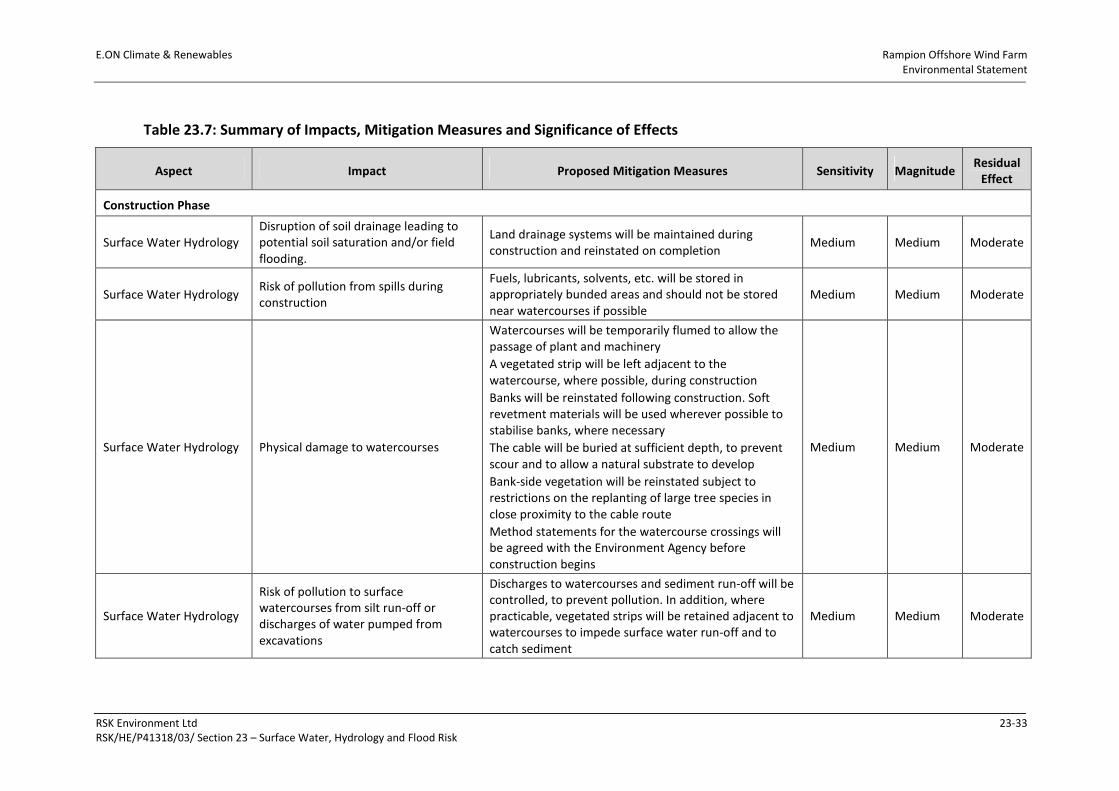
E.ON Climate & Renewables Rampion Offshore Wind Farm
Environmental Statement
RSK Environment Ltd 23-33
RSK/HE/P41318/03/ Section 23 – Surface Water, Hydrology and Flood Risk
Table 23.7: Summary of Impacts, Mitigation Measures and Significance of Effects
Aspect Impact Proposed Mitigation Measures Sensitivity Magnitude Residual
Effect
Construction Phase
Surface Water Hydrology
Disruption of soil drainage leading to
potential soil saturation and/or field
flooding.
Land drainage systems will be maintained during
construction and reinstated on completion Medium Medium Moderate
Surface Water Hydrology Risk of pollution from spills during
construction
Fuels, lubricants, solvents, etc. will be stored in
appropriately bunded areas and should not be stored
near watercourses if possible
Medium Medium Moderate
Surface Water Hydrology Physical damage to watercourses
Watercourses will be temporarily flumed to allow the
passage of plant and machinery
A vegetated strip will be left adjacent to the
watercourse, where possible, during construction
Banks will be reinstated following construction. Soft
revetment materials will be used wherever possible to
stabilise banks, where necessary
The cable will be buried at sufficient depth, to prevent
scour and to allow a natural substrate to develop
Bank-side vegetation will be reinstated subject to
restrictions on the replanting of large tree species in
close proximity to the cable route
Method statements for the watercourse crossings will
be agreed with the Environment Agency before
construction begins
Medium Medium Moderate
Surface Water Hydrology
Risk of pollution to surface
watercourses from silt run-off or
discharges of water pumped from
excavations
Discharges to watercourses and sediment run-off will be
controlled, to prevent pollution. In addition, where
practicable, vegetated strips will be retained adjacent to
watercourses to impede surface water run-off and to
catch sediment
Medium Medium Moderate
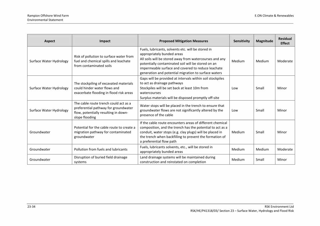
Rampion Offshore Wind Farm E.ON Climate & Renewables
Environmental Statement
23-34 RSK Environment Ltd
RSK/HE/P41318/03/ Section 23 – Surface Water, Hydrology and Flood Risk
Aspect Impact Proposed Mitigation Measures Sensitivity Magnitude Residual
Effect
Surface Water Hydrology
Risk of pollution to surface water from
fuel and chemical spills and leachate
from contaminated soils
Fuels, lubricants, solvents etc. will be stored in
appropriately bunded areas
All soils will be stored away from watercourses and any
potentially contaminated soil will be stored on an
impermeable surface and covered to reduce leachate
generation and potential migration to surface waters
Medium Medium Moderate
Surface Water Hydrology
The stockpiling of excavated materials
could hinder water flows and
exacerbate flooding in flood risk areas
Gaps will be provided at intervals within soil stockpiles
to act as drainage pathways
Stockpiles will be set back at least 10m from
watercourses
Surplus materials will be disposed promptly off-site
Low Small Minor
Surface Water Hydrology
The cable route trench could act as a
preferential pathway for groundwater
flow, potentially resulting in down-
slope flooding
Water stops will be placed in the trench to ensure that
groundwater flows are not significantly altered by the
presence of the cable
Low Small Minor
Groundwater
Potential for the cable route to create a
migration pathway for contaminated
groundwater
If the cable route encounters areas of different chemical
composition, and the trench has the potential to act as a
conduit, water stops (e.g. clay plugs) will be placed in
the trench when backfilling to prevent the formation of
a preferential flow path
Medium Small Minor
Groundwater Pollution from fuels and lubricants Fuels, lubricants solvents, etc., will be stored in
appropriately bunded areas Medium Medium Moderate
Groundwater Disruption of buried field drainage
systems
Land drainage systems will be maintained during
construction and reinstated on completion Medium Small Minor
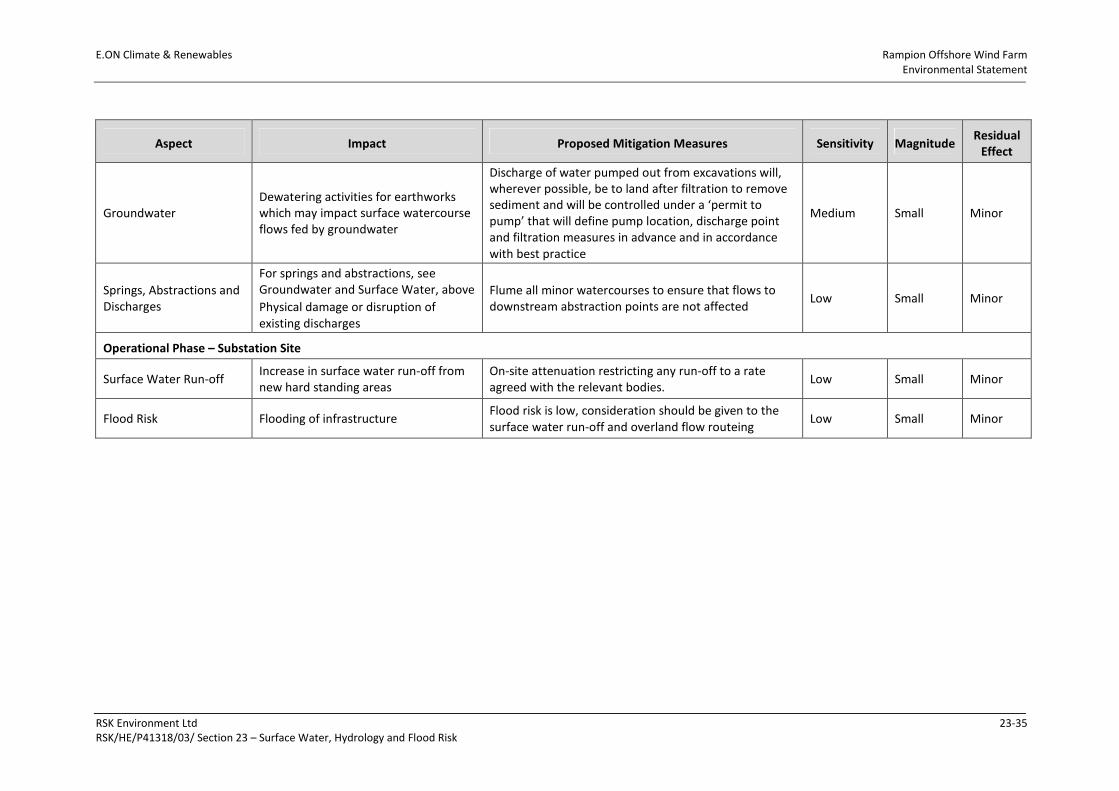
E.ON Climate & Renewables Rampion Offshore Wind Farm
Environmental Statement
RSK Environment Ltd 23-35
RSK/HE/P41318/03/ Section 23 – Surface Water, Hydrology and Flood Risk
Aspect Impact Proposed Mitigation Measures Sensitivity Magnitude Residual
Effect
Groundwater
Dewatering activities for earthworks
which may impact surface watercourse
flows fed by groundwater
Discharge of water pumped out from excavations will,
wherever possible, be to land after filtration to remove
sediment and will be controlled under a ‘permit to
pump’ that will define pump location, discharge point
and filtration measures in advance and in accordance
with best practice
Medium Small Minor
Springs, Abstractions and
Discharges
For springs and abstractions, see
Groundwater and Surface Water, above
Physical damage or disruption of
existing discharges
Flume all minor watercourses to ensure that flows to
downstream abstraction points are not affected Low Small Minor
Operational Phase – Substation Site
Surface Water Run-off Increase in surface water run-off from
new hard standing areas
On-site attenuation restricting any run-off to a rate
agreed with the relevant bodies. Low Small Minor
Flood Risk Flooding of infrastructure Flood risk is low, consideration should be given to the
surface water run-off and overland flow routeing Low Small Minor