The Office of the Dean of Students December 20, 2003 Projects: Interactive Campus Map (ICM)...
37
The Office of the Dean of Students December 20, 2003 Projects: Interactive Campus Map (ICM) Adjustable Book Shelf (ABS) Global Positioning System Device for the Visually Impaired (GPS-DVI)
-
Upload
paulina-alexander -
Category
Documents
-
view
216 -
download
2
Transcript of The Office of the Dean of Students December 20, 2003 Projects: Interactive Campus Map (ICM)...

The Office of the Dean of Students
December 20, 2003Projects:
Interactive Campus Map (ICM)Adjustable Book Shelf (ABS)
Global Positioning System Device for the Visually Impaired (GPS-DVI)

ICM
Objective: To help students with physical disabilities locate the best accessible path between campus locations by drawing a map
Team members Jeff Turkstra Abdul Zahid Avirul Sharma Vishnu Jaju

Semester Goals Obtain and configure Kiosk Expand coverage area Plan improvements
Better map image(s) Turn-by-turn directions
Actual distance calculations Voice recognition and
synthesis
Begin work on prototype GPS-DVI interface

How does ICM work?
User gives start/end information on website
Calculate shortest path Draw map Encode Image Display

Web-Interface
Facilitates channeling of the user input data to the best path implementation routine
Simple and easy to use Easy to maintain for future semesters Accessible via home computers, not just kiosk
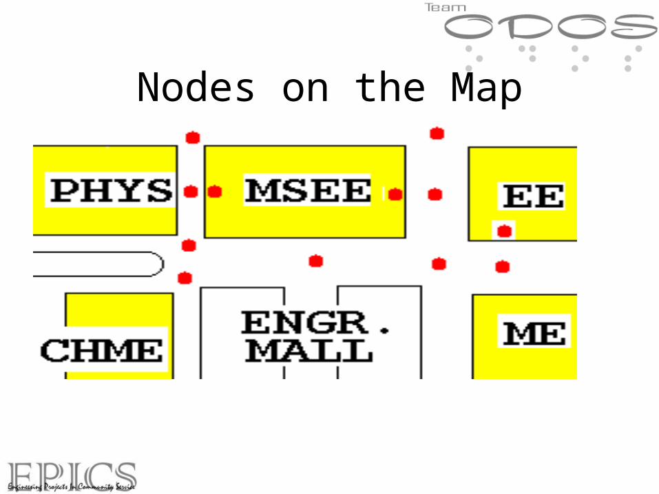
Nodes on the Map

Node Database Database example For GPS coordinates (Latitude, Longitude)
Node Name GPS Coordinates TYPE Neighbors
1 PHYS 6.285, 1.225 Door 2,4,9,10
2 MSEE(NW) 6.654, 3.256 Door 1,7,9,14
3 MSEE(SE) 6.542, 3.2545 Door 4,5,6
4 INT1 6.021, 3.021 Intersection 1,3,6

Cool live demo!

Kiosk
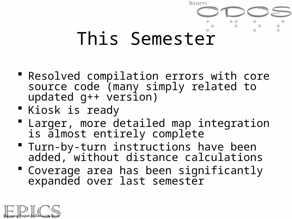
This Semester
Resolved compilation errors with core source code (many simply related to updated g++ version)
Kiosk is ready Larger, more detailed map integration is almost
entirely complete Turn-by-turn instructions have been added, without
distance calculations Coverage area has been significantly expanded over
last semester

Current Coverage Area
Engineering Mall (from last semester) Area surrounding (and including) BRNG,
MATH, and CL50 Clock tower area (SC, CS, PSY) “Chemistry” area (WTHR, BRWN, GRIS,
HEAV, etc)

Prototype Ideas
Work has been done on planning methods to interface with GPS-DVI
Theoretical design for mysql driven PHP interface permitting the “posting” of current GPS coordinates and destination coordinates to the server, which would in turn generate and send back a map with text based turn-by-turn directions

What’s Left?
Dynamic map cropping/resizing (current map is incredibly large)
Improve path drawing algorithm on map Distance calculations with turn-by-turn
directions Install Kiosk Project should theoretically be completed next
semester

Adjustable Book Shelf
Team Members :
Sandeep Nandy (Project Leader)
Ankit Dhawan Vineet Alva
Shohei Shibata Rayelle Duncan
Aman Sewani

Agenda
Timeline Design Parameters Concept #1: Turn Shelf Concept Concept #2: Slide Down Concept Modification of Slide Down Future Plans

Timeline

Design Parameters
Cost less than $500 Requires very little muscle force by user Hold at least 8 – 10 books Makes use of current dorm shelving unit All books are attainable from a seated position

Turn Shelf 3-D view

Turn Shelf
Book Capacity determined (12 books 2” thick) Max weight it will experience ~50 lbs The concept was not used for practicality
reasons: It only lowers the top shelf by 8”, not worth the complicated mechanisms

Slide Down Bookshelf Design
•An adjustable bookshelf that fits inside the existing shelf.•Slides down at an angle onto the desk.•It will contain about 120lbs of books when fully packed.

Slide Down Design Improvements

Garage Door Concept Dimensions are based on the
Tarkington and Wiley bookshelves
Shelf will be lowered in the same manner as a garage door using a small garage door motor.
Inside shell resemble “open” position of garage door.
Down on desk to resemble “Closed” position of garage.

Future Plans
Exact procedure and mechanisms for raising and lowering bookshelf
Safety Measures Research possibility of incorporating design to
be compatible to all of the dorms on campus Survey University Residences for their input

GPS-DVIGPS-DVIGlobal Positioning System - Global Positioning System -
Device for the Visually Device for the Visually ImpairedImpaired
Ryan Hicks Chan Park
Howard Lityo Jason Lim
Sivanit Ratanadi Ali Shareef
Guneet Chadah
Epics Team Mobility Team
-- Advisor – Prof. Lehnert-- Advisor – Prof. Lehnert

OverviewOverview
► IntroductionIntroduction
►Project TasksProject Tasks
►Project PlanningProject Planning
►ConclusionConclusion

IntroductionIntroduction
►Objective : To design and implement a Objective : To design and implement a portable device that will enable portable device that will enable students who are visually impaired to students who are visually impaired to navigate around campus with the use navigate around campus with the use of the global positioning system.of the global positioning system.
►Solution : Program – “Campus-NAV”Solution : Program – “Campus-NAV” Integrates GPS receiver and PDA to Integrates GPS receiver and PDA to
help user navigate around campus.help user navigate around campus.

Project TasksProject Tasks
►Defined sub-groups for each taskDefined sub-groups for each task
GPS-DVI
Search algorithm Device driver GUI Voice Output
Shareef, Jason Howard, Guneet & Ryan Pete & Chan Guneet,Pete & Chan
Project TasksProject Tasks
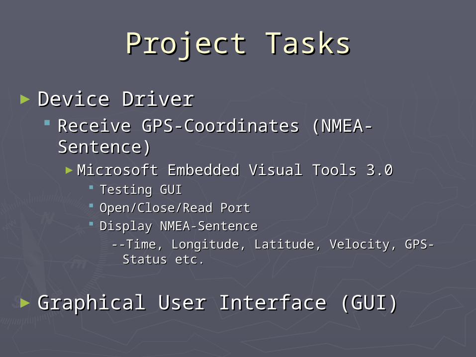
►Device DriverDevice Driver Receive GPS-Coordinates (NMEA-Sentence)Receive GPS-Coordinates (NMEA-Sentence)
►Microsoft Embedded Visual Tools 3.0Microsoft Embedded Visual Tools 3.0 Testing GUITesting GUI Open/Close/Read PortOpen/Close/Read Port Display NMEA-Sentence Display NMEA-Sentence
--Time, Longitude, Latitude, Velocity, GPS-Status etc. --Time, Longitude, Latitude, Velocity, GPS-Status etc.
►Graphical User Interface (GUI)Graphical User Interface (GUI)

Pocket PC hp jornada
•
•
•
•
•
•
•
•
•
•
• • • •
•
GPS-DVI System GUIGPS-DVI System GUI
Enter
Power
1 2 3
4 5 6
7 8 9
0Reset

Project TasksProject Tasks
► Voice OutputVoice Output Verbal response to user’s inputVerbal response to user’s input
► Text Aloud SoftwareText Aloud Software Creates MP3 file from text inputCreates MP3 file from text input
► Search AlgorithmSearch Algorithm Finds shortest path from source node to Finds shortest path from source node to
destination node destination node► Dijkstra’s AlgorithmDijkstra’s Algorithm
Campus MapCampus Map Campus DatabaseCampus Database Adjacency MatrixAdjacency Matrix
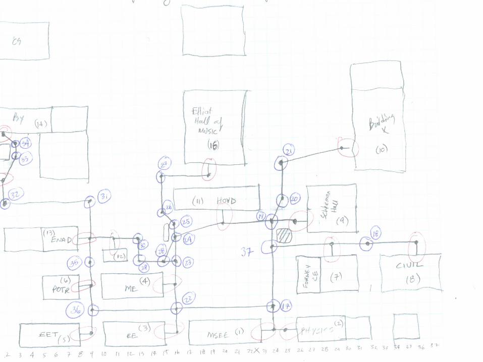

Campus DatabaseCampus Database► Node x y NumAdjNode AdjNodes CommentNode x y NumAdjNode AdjNodes Comment► 0 0 0 1 0 0 0 1 0 Origin0 Origin► 1 24 1 2 1 24 1 2 2 17 MSEE 2 17 MSEE ► 2 25 1 1 2 25 1 1 1 Physics 1 Physics ► 3 16 1 1 3 16 1 1 22 EE22 EE► 4 16 5 2 4 16 5 2 22 23 ME22 23 ME► 5 9 1 1 5 9 1 1 36 EET36 EET► 6 9 5 2 6 9 5 2 35 36 Potr35 36 Potr► 7 29 8 2 7 29 8 2 18 37 CE18 37 CE► 8 36 8 1 8 36 8 1 18 CIVIL18 CIVIL► 9 26 10 1 9 26 10 1 19 Scheleman19 Scheleman► 10 30 16 1 10 30 16 1 21 BuildX21 BuildX► 11 20 10 2 11 20 10 2 19 24 Hovd19 24 Hovd► 12 11 9 2 12 11 9 2 13 30 SS13 30 SS► 13 9 9 3 13 9 9 3 12 31 35 ENAD12 31 35 ENAD► 14 2 18 1 14 2 18 1 34 Pshsy34 Pshsy► 15 2 14 2 15 2 14 2 32 33 SC32 33 SC► 16 19 14 1 16 19 14 1 27 Elliot 27 Elliot► 17 24 3 3 17 24 3 3 1 22 37 Int 1 22 37 Int► 18 32 8 2 18 32 8 2 7 8 Int 7 8 Int► 19 24 10 3 19 24 10 3 11 20 37 Int 11 20 37 Int► 20 25 12 2 20 25 12 2 19 21 Int19 21 Int► The GUI displays shortest path from source to destination.The GUI displays shortest path from source to destination.

Adjacency MatrixAdjacency Matrix


Project PlanningProject Planning► Convert Campus Database XY coordinates to GPS Convert Campus Database XY coordinates to GPS
CoordinatesCoordinates
► Integrate GPS receiver with algorithm so that the Integrate GPS receiver with algorithm so that the GPS receiver guides user across campus and GPS receiver guides user across campus and provides voice output updates:provides voice output updates:
““Turn Right”Turn Right”
““Turn Left”Turn Left”
Expected Due DateExpected Due Date► End of Spring 2004End of Spring 2004
ConclusionConclusion
► Increase Technical KnowledgeIncrease Technical Knowledge Object Oriented Programming (C++)Object Oriented Programming (C++) Compact Flash GPS-ReceiversCompact Flash GPS-Receivers
► National Marine Electronics Association (NMEA) StandardsNational Marine Electronics Association (NMEA) Standards
► Work on a multi-disciplinary TeamWork on a multi-disciplinary Team Different majors, Mobility TeamDifferent majors, Mobility Team
► Increase Communication SkillsIncrease Communication Skills PresentationsPresentations Epics & Mobility TA, Previous Team Members, CompaniesEpics & Mobility TA, Previous Team Members, Companies
► Work on a Poorly Documented ProjectWork on a Poorly Documented Project Gather informationGather information

Thank You!Thank You!