Observational and modeling studies of the impacts of ...
13
Observational and modeling studies of the impacts of agriculture-related land use change on planetary boundary layer processes in the central U.S. Jimmy O. Adegoke a, * , Roger Pielke Sr. b , Andrew M. Carleton c a Laboratory for Climate Analysis and Modeling, Department of Geosciences, University of Missouri-Kansas City, 420 Robert Flarsheim Hall, 5100 Rockhill Road, Kansas City, MO 64110, United States b Department of Atmospheric Sciences, Colorado State University, Fort Collins, CO, United States c Department of Geography & Earth and Environmental Sciences Institute, The Pennsylvania State University, University Park, PA, United States Received 2 December 2004; received in revised form 19 July 2006; accepted 27 July 2006 Abstract The impact of agricultural land use change on atmospheric boundary layer processes, the associated feedbacks and their regional scale impacts, are examined with particular emphasis on the central United States. Specifically, the role of contrasting forested and agricultural land covers in the initiation and subsequent evolution of summertime cloud patterns in the U.S. Midwest; and the impact of agricultural practices, including irrigation, on the surface climate of the U.S. High Plains are discussed in detail. Satellite-based observational results of previous work summarized in this paper indicate that the timing and intensity of cloud development appears to be influenced by both synoptic flow regimes and agricultural land use type. For example, under conditions characterized by high pressure with surface winds generally less than 5 m s 1 , peak cloud development occurred almost two hours earlier over cropland than over the forest or boundary locations in Michigan. Cloud masses were also considerably taller over cropland in the mid- afternoon than over forest and land cover transition zones. The modeling results discussed here for a model domain centered over Nebraska indicate significant differences in the surface energy fluxes between the irrigated (control) and non-irrigated (dry) simulations. Surface latent heat flux was higher by 36% and dewpoint temperature higher by 2.3 8C in the control simulation. Also, surface sensible heat flux of the control simulation was 15% less and the near-ground (2 m) temperature was 1.2 8C less compared to dry run, indicating irrigation-induced surface cooling effect. Recent investigations on crop–climate interactions in which crop and ecological models were coupled to regional climate models show that incorporating important perturbations such as prolonged droughts and the resulting changes in soil and plant nutrient conditions remains one of the biggest challenges in developing effective and realistic ecological-climate integrated modeling systems. # 2006 Elsevier B.V. All rights reserved. Keywords: Crop–climate interactions; Convective clouds; Regional climate modeling; Agricultural land use 1. Introduction The central United States (U.S.) is one of the most agriculturally productive areas in the world and supports a wide range of agro-businesses that are economically vital to the U.S. Together, the High Plains www.elsevier.com/locate/agrformet Agricultural and Forest Meteorology 142 (2007) 203–215 * Corresponding author. Tel.: +1 816 235 2978; fax: +1 816 235 5535. E-mail address: [email protected] (J.O. Adegoke). 0168-1923/$ – see front matter # 2006 Elsevier B.V. All rights reserved. doi:10.1016/j.agrformet.2006.07.013
Transcript of Observational and modeling studies of the impacts of ...

www.elsevier.com/locate/agrformet
Agricultural and Forest Meteorology 142 (2007) 203–215
Observational and modeling studies of the impacts of
agriculture-related land use change on planetary
boundary layer processes in the central U.S.
Jimmy O. Adegoke a,*, Roger Pielke Sr.b, Andrew M. Carleton c
a Laboratory for Climate Analysis and Modeling, Department of Geosciences, University of Missouri-Kansas City,
420 Robert Flarsheim Hall, 5100 Rockhill Road, Kansas City, MO 64110, United Statesb Department of Atmospheric Sciences, Colorado State University, Fort Collins, CO, United States
c Department of Geography & Earth and Environmental Sciences Institute, The Pennsylvania State University,
University Park, PA, United States
Received 2 December 2004; received in revised form 19 July 2006; accepted 27 July 2006
Abstract
The impact of agricultural land use change on atmospheric boundary layer processes, the associated feedbacks and their regional
scale impacts, are examined with particular emphasis on the central United States. Specifically, the role of contrasting forested and
agricultural land covers in the initiation and subsequent evolution of summertime cloud patterns in the U.S. Midwest; and the impact
of agricultural practices, including irrigation, on the surface climate of the U.S. High Plains are discussed in detail. Satellite-based
observational results of previous work summarized in this paper indicate that the timing and intensity of cloud development appears
to be influenced by both synoptic flow regimes and agricultural land use type. For example, under conditions characterized by high
pressure with surface winds generally less than 5 m s�1, peak cloud development occurred almost two hours earlier over cropland
than over the forest or boundary locations in Michigan. Cloud masses were also considerably taller over cropland in the mid-
afternoon than over forest and land cover transition zones. The modeling results discussed here for a model domain centered over
Nebraska indicate significant differences in the surface energy fluxes between the irrigated (control) and non-irrigated (dry)
simulations. Surface latent heat flux was higher by 36% and dewpoint temperature higher by 2.3 8C in the control simulation. Also,
surface sensible heat flux of the control simulation was 15% less and the near-ground (2 m) temperature was 1.2 8C less compared to
dry run, indicating irrigation-induced surface cooling effect. Recent investigations on crop–climate interactions in which crop and
ecological models were coupled to regional climate models show that incorporating important perturbations such as prolonged
droughts and the resulting changes in soil and plant nutrient conditions remains one of the biggest challenges in developing effective
and realistic ecological-climate integrated modeling systems.
# 2006 Elsevier B.V. All rights reserved.
Keywords: Crop–climate interactions; Convective clouds; Regional climate modeling; Agricultural land use
* Corresponding author. Tel.: +1 816 235 2978;
fax: +1 816 235 5535.
E-mail address: [email protected] (J.O. Adegoke).
0168-1923/$ – see front matter # 2006 Elsevier B.V. All rights reserved.
doi:10.1016/j.agrformet.2006.07.013
1. Introduction
The central United States (U.S.) is one of the most
agriculturally productive areas in the world and
supports a wide range of agro-businesses that are
economically vital to the U.S. Together, the High Plains
J.O. Adegoke et al. / Agricultural and Forest Meteorology 142 (2007) 203–215204
and Midwest states account for more than 75% of the
total land area under grain cultivation and about 45% of
U.S. cattle inventory (National Agricultural Statistics
Services (NASS) of the United States Department of
Agriculture (USDA) USDA/NASS—U.S. 2002 Agri-
cultural Census). Following the westward expansion of
European settlement over the past 100–150 years, this
region experienced massive land use changes from the
conversion of the native vegetation to farmlands. By
some estimates, over 90% of the tall grass prairie native
to the eastern section of the High Plains has been
converted to managed agriculture, including irrigation
(Samson and Knopf, 1994). In the Midwest, the change
has been dominantly from the conversion of forested
areas into cropped regions (Iverson and Risser, 1987). A
distinct feature of this Midwest land cover transforma-
tion are the narrow and often extensive transition
boundaries separating cooler, moist forested areas from
relatively warm and drier cropped areas (Carleton and
O’Neal, 1995).
Large scale anthropogenic modification of vegeta-
tion alters various physical properties of the land
surface (e.g., albedo, surface roughness, leaf area index,
and rooting depth) which have been shown to influence
climate over a range of spatial and temporal scales
(Pielke and Avissar, 1990; Adegoke and Carleton,
2000). In addition, agriculture-related land cover
conversion affects landscape heterogeneity, which
observational and modeling studies show could affect
the development of small cumulus clouds and
potentially induce mesoscale circulations. The latter
are important because they can significantly enhance
the rainfall associated with synoptic scale cyclonic
systems. For example, Marotz et al. (1975) showed that
cloud fields in Kansas during the warm season are
differentiated between irrigated and non-irrigated areas.
Other studies have also shown that shallow cumulus
clouds tend to form earlier and became more numerous
over a landscape of wheat stubble than over adjacent
landscapes of pasture and row crops in Oklahoma
(Rabin et al., 1990; Wetzel et al., 1996). Similarly,
differences in cumulus convection (amount, timing)
occur between cropped and forested areas in the
Midwest (Carleton et al., 2001). Using data from
Oklahoma Mesonet Network, McPherson et al. (2004)
investigated the impact of winter wheat on surface
climate in Oklahoma and found a summer (winter)
warming (cooling) in the winter wheat region relative to
the surrounding area. Modeling studies support these
findings and also show that local wind circulations as
intense as the land–sea breeze can develop. Thunder-
storm severity can be enhanced in the horizontal wind
convergence region that develops because of the
differential heating between areas of forest that are
not moisture stressed and the adjacent dry, vegetated
land (Segal et al., 1988; Pielke and Zeng, 1989).
Similarly, Weaver and Avissar (2001) reported simu-
lated vertical velocities of 1–2 m s�1 due primarily to
landscape heterogeneity associated with winter wheat
farming in Oklahoma. These vertical velocities were
shown to coincide with satellite observations of
cumulus clouds, implying that the enhanced vertical
velocities could have been strong enough to induce
convective cloud formation.
The primary mechanism by which land surface
modifications and changes influence climate is through
controlling the transfer of heat and moisture into the
planetary boundary layer (Pielke, 2001). The horizontal
contrasts in vegetation and phenological stage, surface
and soil moisture conditions, and evapotranspiration
(ET) between cropped areas and adjacent land covers,
can each affect boundary layer processes such as
surface energy partitioning. For example, when the soil
is wet from recent rainfall energy exchange between the
surface and the overlying atmosphere will mostly be in
the form of latent heat. Conversely, energy transfer will
be primarily in the form of sensible heat under dry soil
conditions. These bio-physical processes alter surface
temperature patterns by strengthening the horizontal
temperature gradient and may impact the convective
available potential energy (CAPE) or other measures of
cumulus cloud activity such as satellite-observed
outgoing longwave radiation (OLR) (Raymond et al.,
1994; Carleton et al., 1994, 2001; Segal et al., 1995;
Chase et al., 1999; Pielke, 2001; Hanesiak et al., 2004).
The lower albedo and infrared emission values of
vegetated surfaces imply an increase in net radiation
absorbed at the surface compared to adjacent cleared or
deforested areas. This increased available energy results
in elevated rates of evaporation and transpiration and, to
a much lesser extent, photosynthesis. The higher ET
rates result in a moister lower atmosphere with higher
equivalent potential temperature.
Furthermore, the increased aerodynamic roughness
of forested areas can reduce low-level wind speeds,
increase the intensity of turbulence and, subsequently,
favor the formation of convective clouds over vegetated
areas (Rabin et al., 1990; Wetzel, 1990; Carleton et al.,
2001). A comprehensive review of both the physics and
relevant published work on the influence of surface
vegetation changes on cumulus cloud development can
be found in Pielke (2001). While this paper draws on
insights from previous published work relevant to this
topic, we focus primarily on our recent observational

J.O. Adegoke et al. / Agricultural and Forest Meteorology 142 (2007) 203–215 205
and modeling studies in the central U.S. The paper is
organized into two sections. In the first section we
explore the role of contrasting forested and agricultural
land areas in the formation of convective clouds in the
Midwest. In the second section we focus on simulations
of the impact of U.S. Plains agriculture, especially
irrigated agriculture, on PBL processes notably surface
energy partitioning and near-ground temperature using
the Colorado State University (CSU) Regional Atmo-
spheric Modeling System (RAMS). In this study the
central U.S. is defined to include the extensive flatlands
of the High Plains states of Nebraska, the Dakotas,
Kansas and northern Oklahoma; the humid lowlands of
the Midwest (i.e., central and northern Illinois, Indiana
and Ohio); and the surrounding areas of rolling
topography that support mostly natural (i.e., forest)
growth. The latter occur especially in the southern parts
of Missouri and Indiana.
2. Observational studies
The possible role of contrasting forested and
agricultural land covers in the formation of convective
clouds in the Midwest, especially during extreme
climatic events such as the 1988 drought, has been
investigated by a number of researchers. Examples
include the studies by Carleton et al. (1994), Rabin and
Martin (1996) and O’Neal (1996), in which both
conventional land use data and satellite observations of
surface and cloud conditions were used to investigate
interactions between convective cloud development
and features such as land cover and surface moisture
status in the Midwest. The patterns of cumulus
convection determined from the analysis of satellite
imagery in these studies show a strongly diurnal cycle
and apparent associations with land cover types. Other
studies (e.g., Travis, 1997; Brown and Arnold, 1998)
suggest that during the warm mid-summer months,
convective cloud masses tend to be organized along
wind convergence boundaries (central Wisconsin) and
boundaries of land cover (e.g., between forests and
agricultural land) and even soil order (Illinois). These
boundaries are important because they may enhance
the convergence of near-surface winds thereby increas-
ing the likelihood of moist convection during synopti-
cally ‘‘weak flow’’ situations. Deep convection is a
major contributor to the warm season precipitation
regime of the central U.S., particularly the Midwest
region (Winkler et al., 1988; Easterling, 1989), and
occurs as air mass showers and thunderstorms
associated with weak flow patterns, and thunderstorms
organized as either mesoscale systems or in association
with baroclinic features (e.g., Fritsch et al., 1986;
Moller et al., 1994; Hanesiak et al., 2004).
While these studies provided many useful insights
into the land surface-convective cloud coupling over the
Midwest, they were mostly based on composites of a few
case study days for one or two growing seasons. A
comprehensive study based on systematic analyses of
multi-year data was needed to determine whether the
convective cloud–land surface associations reported in
those previous studies are evident over longer-term
periods, under the usual range of climate conditions (i.e.,
non-drought, non-flood). The first attempt at conducting
such a comprehensive study (Adegoke, 2000) produced
several interesting findings, some of which were reported
in Adegoke and Carleton (2000), Carleton et al. (2001)
and Adegoke and Carleton (2002). The discussion in the
following paragraphs is based, in part, on these analyses
of land surface-convective cloud associations during the
summer months (June, July and August) for the 1991–
1998 period. The study integrated high-resolution multi-
year satellite data with detailed land use-land cover
(LULC) datasets and sought answers to the following
questions: What associations exist between broad Mid-
west land cover categories (e.g., cropland and forest) and
convective clouds (determined from hourly GOES
satellite imagery) under conditions of weak, moderate
and strong synoptic flow? How do the boundaries
between farmlands and forested areas affect convective
cloud formation under the various synoptic flow
conditions?
2.1. Cloud–land cover relationships
The retrieval of satellite cloud data and the
determination of cloud associations with land cover
characteristics involved several steps. First, the hourly
GOES IR and VIS satellite images were geometrically
registered to the same projection (Albers Equal Area
Projection) as the Midwest LULC map described in the
preceding section. To compensate for the effects of
varying solar elevation angle (z), the VIS brightness
counts were converted to albedo (a), using the Garand
(1988) algorithm:
a ¼ aB2 þ b
I0 cos z
where a, b and I0, are calibration constants for the
GOES-7 and GOES-8 sensors. Then hourly cloud IR
and VIS pixel data were extracted for 40-km square
grids centered over cropland, forest and transitional
(boundary) representative sites in Illinois, Indiana

J.O. Adegoke et al. / Agricultural and Forest Meteorology 142 (2007) 203–215206
and Missouri respectively. The boundary locations were
included to investigate the possible effect of abrupt
surface discontinuities on convective cloud initiation.
Summary statistics representing mean cloud amounts
(from the VIS), and mean cloud top temperatures (CTT)
(from IR) were calculated for each synoptic flow type
and stratified according to land cover (i.e., cropland,
forest and boundary). Hourly VIS brightness and CTT
data composites for all ‘‘best weak flow’’ days for target
sites in three Midwest states (Michigan, Indiana and
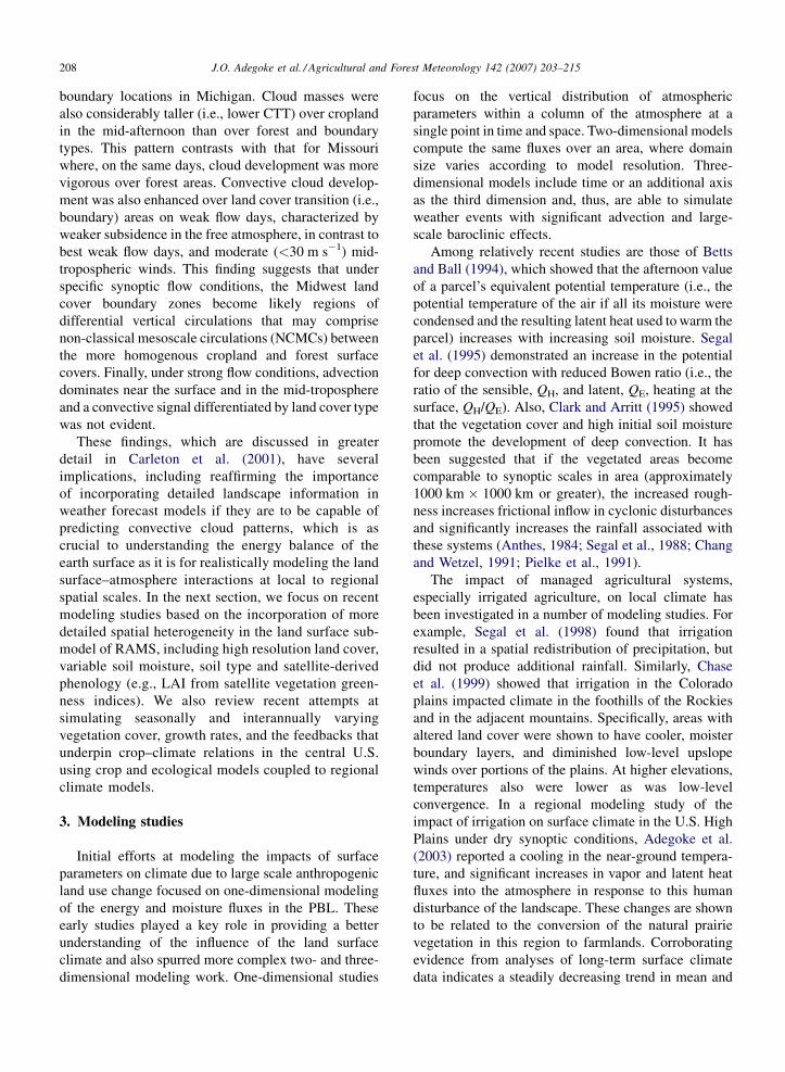
Missouri) are shown in Fig. 1. The VIS data (Fig. 1a–c)
Fig. 1. ‘‘Best weak flow’’ day mean hourly albedo (VIS) and infra red clou
boundary (b and e) and forest (c and f) in Michigan (adapted from Adego
show that cloud development peaked about one and half
to two hours earlier, and also persisted longer, over
cropland than over the forest or boundary locations; at
least, in Michigan. Also, cloud masses in Michigan
were considerably taller (i.e., lower CTT) over cropland
(Fig. 1d) in the mid-afternoon than over the boundary
(Fig. 1e) or forest (Fig. 1f) land cover types. The mid-
afternoon (12 p.m.–3 p.m. local time) mean albedo
value was about 20–25% greater over cropland in
Michigan than the adjacent boundary and forest
areas. The pattern of land cover-cloud associations in
d top temperature (IR CTT) (K) composites over cropland (a and d),
ke, 2000).

J.O. Adegoke et al. / Agricultural and Forest Meteorology 142 (2007) 203–215 207
Fig. 2. ‘‘Best weak flow’’ day mean maximum brightness (K) com-
posites for Michigan (a) and Missouri (b) (adapted from Adegoke,
2000).
Michigan contrasts with the situation in Missouri. In
Missouri, cloud development (depicted by the higher
average maximum VIS brightness) is more pronounced
over the forest location (Fig. 2). The observed lag in the
time of cloud formation over more forested locations
and the apparent difference in the cloud response
patterns for Michigan and Missouri appear to be partly
due to differences in the PBL moisture and temperature
characteristics of the two sites. Analyses of thermo-
dynamic and moisture indices derived from radiosonde
data indicate that the lower atmosphere is drier in
Michigan compared to Missouri, where cloud growth
tend to be more vigorous over forest areas (Table 1).
Table 1
Thermodynamic indices for composite ‘‘best weak flow’’ days: 12Z radios
CCL (mb) CCL-EL (mb) K-index Tc (8C)
Michigan 749 480 12 32
Missouri 827 528 29 26.8
CCL: convective condensation level by surface heating; CCL-EL: depth (mb
non-severe convective showers; Tc: temperature required for free convection f
layer; mean T �Tv: mean wet-bulb depression for surface-850 mb layer (m
surface-850 mb layer; W: water content (cm) in the air column from surfa
These findings seem to confirm the hypothesis that
clouds form earlier and persist longer over drier
(cropped) areas under relatively dry atmospheric con-
ditions, and later over moister (forest) areas when the
convective potential of the PBL is greater and the
atmosphere is less dry.
In contrast to the ‘‘best weak flow’’ composites, the
‘‘weak flow’’ days were characterized by greater
convective activity (i.e., cumulus cloud cover) over
boundary areas in all three states (not shown). The mean
mid-morning to mid-afternoon VIS albedo value over
the three boundary areas is 0.72, while similar mean
values for cropland and forest are 0.59 and 0.61
respectively (i.e., a difference of between 18 and 25% in
the albedo values between the boundary, cropland and
forest areas). This result is important in that it provides
empirical evidence over several summer seasons that
confirms earlier theoretical and observational studies.
The latter suggested that surface discontinuities, such as
organized land-cover boundaries, could enhance con-
vective cloud formation similar to a sea-breeze-like
circulation forced by differential heating (Pielke et al.,
1991; Rabin et al., 1990). The difference in cloud
response to land cover forcing between the ‘‘weak
flow’’ and ‘‘best weak flow’’ days may be due, in part, to
the slightly more vigorous synoptic environment (e.g.,
faster mid-troposphere winds) during ‘‘weak flow’’ as
opposed to ‘‘best weak flow’’ days. Hourly VIS and IR
data for ‘‘strong flow’’ day composites did not indicate
any cloud pattern differentiation by land cover type or
surface boundaries. The late-morning to mid-afternoon
thermally forced peak in the cloud VIS albedo values
over cropland in Michigan (evident in the mean
statistics of the ‘‘best weak flow’’ cases) is absent, as
would be expected, in the ‘‘strong flow’’ composites.
In summary, the satellite-based observational results
first reported in Carleton et al. (2001) and summarized
here indicate that under ‘‘best weak flow’’ conditions
(defined as days characterized by high pressure aloft
and at the surface with winds generally less than
5 m s�1), clouds attained peak development almost two
hours earlier over cropland than over the forest or
onde data
Mean Tv (8C) Mean T � Tv (8C) RH (%) Mean W (cm)
16 3.7 68 0.18
20.5 2.7 78 0.33
) of the positive layer; K-index: stability measure useful for prediction
rom the surface; mean Tv: mean virtual temperature for surface-850 mb
easure of the relative dryness of air); RH: mean relative humidity for
ce-850 mb.
J.O. Adegoke et al. / Agricultural and Forest Meteorology 142 (2007) 203–215208
boundary locations in Michigan. Cloud masses were
also considerably taller (i.e., lower CTT) over cropland
in the mid-afternoon than over forest and boundary
types. This pattern contrasts with that for Missouri
where, on the same days, cloud development was more
vigorous over forest areas. Convective cloud develop-
ment was also enhanced over land cover transition (i.e.,
boundary) areas on weak flow days, characterized by
weaker subsidence in the free atmosphere, in contrast to
best weak flow days, and moderate (<30 m s�1) mid-
tropospheric winds. This finding suggests that under
specific synoptic flow conditions, the Midwest land
cover boundary zones become likely regions of
differential vertical circulations that may comprise
non-classical mesoscale circulations (NCMCs) between
the more homogenous cropland and forest surface
covers. Finally, under strong flow conditions, advection
dominates near the surface and in the mid-troposphere
and a convective signal differentiated by land cover type
was not evident.
These findings, which are discussed in greater
detail in Carleton et al. (2001), have several
implications, including reaffirming the importance
of incorporating detailed landscape information in
weather forecast models if they are to be capable of
predicting convective cloud patterns, which is as
crucial to understanding the energy balance of the
earth surface as it is for realistically modeling the land
surface–atmosphere interactions at local to regional
spatial scales. In the next section, we focus on recent
modeling studies based on the incorporation of more
detailed spatial heterogeneity in the land surface sub-
model of RAMS, including high resolution land cover,
variable soil moisture, soil type and satellite-derived
phenology (e.g., LAI from satellite vegetation green-
ness indices). We also review recent attempts at
simulating seasonally and interannually varying
vegetation cover, growth rates, and the feedbacks that
underpin crop–climate relations in the central U.S.
using crop and ecological models coupled to regional
climate models.
3. Modeling studies
Initial efforts at modeling the impacts of surface
parameters on climate due to large scale anthropogenic
land use change focused on one-dimensional modeling
of the energy and moisture fluxes in the PBL. These
early studies played a key role in providing a better
understanding of the influence of the land surface
climate and also spurred more complex two- and three-
dimensional modeling work. One-dimensional studies
focus on the vertical distribution of atmospheric
parameters within a column of the atmosphere at a
single point in time and space. Two-dimensional models
compute the same fluxes over an area, where domain
size varies according to model resolution. Three-
dimensional models include time or an additional axis
as the third dimension and, thus, are able to simulate
weather events with significant advection and large-
scale baroclinic effects.
Among relatively recent studies are those of Betts
and Ball (1994), which showed that the afternoon value
of a parcel’s equivalent potential temperature (i.e., the
potential temperature of the air if all its moisture were
condensed and the resulting latent heat used to warm the
parcel) increases with increasing soil moisture. Segal
et al. (1995) demonstrated an increase in the potential
for deep convection with reduced Bowen ratio (i.e., the
ratio of the sensible, QH, and latent, QE, heating at the
surface, QH/QE). Also, Clark and Arritt (1995) showed
that the vegetation cover and high initial soil moisture
promote the development of deep convection. It has
been suggested that if the vegetated areas become
comparable to synoptic scales in area (approximately
1000 km � 1000 km or greater), the increased rough-
ness increases frictional inflow in cyclonic disturbances
and significantly increases the rainfall associated with
these systems (Anthes, 1984; Segal et al., 1988; Chang
and Wetzel, 1991; Pielke et al., 1991).
The impact of managed agricultural systems,
especially irrigated agriculture, on local climate has
been investigated in a number of modeling studies. For
example, Segal et al. (1998) found that irrigation
resulted in a spatial redistribution of precipitation, but
did not produce additional rainfall. Similarly, Chase
et al. (1999) showed that irrigation in the Colorado
plains impacted climate in the foothills of the Rockies
and in the adjacent mountains. Specifically, areas with
altered land cover were shown to have cooler, moister
boundary layers, and diminished low-level upslope
winds over portions of the plains. At higher elevations,
temperatures also were lower as was low-level
convergence. In a regional modeling study of the
impact of irrigation on surface climate in the U.S. High
Plains under dry synoptic conditions, Adegoke et al.
(2003) reported a cooling in the near-ground tempera-
ture, and significant increases in vapor and latent heat
fluxes into the atmosphere in response to this human
disturbance of the landscape. These changes are shown
to be related to the conversion of the natural prairie
vegetation in this region to farmlands. Corroborating
evidence from analyses of long-term surface climate
data indicates a steadily decreasing trend in mean and

J.O. Adegoke et al. / Agricultural and Forest Meteorology 142 (2007) 203–215 209
maximum air temperature at locations within heavily
irrigated areas (Mahmood and Hubbard, 2002; Mah-
mood et al., 2004), thus confirming the irrigation-
induced cooling effect suggested by the RAMS
simulations. The changes in ambient temperature and
surface fluxes observed in Adegoke et al. (2003) clearly
indicate that key components of the PBL, particularly
the partitioning of the available surface energy, are very
sensitive to changes resulting from increased irrigation.
These are examined in greater detail in the next section.
3.1. Irrigation impact on PBL processes and
surface climate
Early observational studies (Marotz et al., 1975;
Barnston and Schickendanz, 1984; Alpert and Mandel,
1986; Pielke and Zeng, 1989) showed that irrigation is
one of the key anthropogenic factors influencing
climate trends in agricultural/rural areas. Barnston
and Schickendanz (1984), for example, found that
irrigation increased precipitation in the Texas Panhan-
dle when the synoptic condition provided low-level
convergence and uplift, such that the additional
moisture produced by irrigation was allowed to ascend
to cloud base. Alpert and Mandel (1986) also found a
decreasing trend in the diurnal surface wind and
temperature with enhanced irrigation.
More recently, regional scale atmospheric models
have been used in several studies (De Ridder and
Galle’e, 1998; Segal et al., 1998) to simulate the effect
of irrigation on various PBL properties because the
models are particularly suitable for quantifying irriga-
tion-induced in situ and remote changes in climate
elements such as precipitation at meso-scales (i.e.,
horizontal scale 200–2000 km). Segal et al. (1998) used
the fifth-generation Pennsylvania State University–
National Center for Atmospheric Research (PSU–
NCAR) Mesoscale Model (MM5) (Grell et al., 1993)
in their study of irrigated areas in North America. Their
model results suggest an increase in the continental
average rainfall for the present irrigation conditions
compared with those of past irrigation. De Ridder and
Galle’e (1998) used a European regional numerical
model (Mode’le Atmosphe’rique Re’gional—MAR)
and reported a reduction in the diurnal amplitude of
temperature and wind speed when a semiarid surface is
replaced by a partly irrigated one. The potential for
moist convection also increased with surface moisture
availability in their simulations. The primary thermo-
dynamic impact of irrigation is the repartitioning of the
sensible and latent heat fluxes at the affected sites. Thus,
an increase in irrigation or surface wetness reduces
sensible heat flux while increasing ET (Pielke, 2001).
The resulting additional moisture flux could enhance
the characteristic moist static energy within the
convective boundary layer (CBL) and consequently
become thermodynamically more conducive to an
increase in rainfall (Betts et al., 1994; Segal et al.,
1998).
In Nebraska, as in much of the U.S. High Plains, corn
is the dominant crop cultivated during the warm season
months. Irrigated corn, which represented about 10% of
total corn producing areas during the early 1950s, now
comprises nearly 60% of the total corn producing areas
in Nebraska. Data from USDA/NASS for York County
in east-central Nebraska further underscore these
changes. Between 1950 and 1998 the irrigated corn
area in York County increased from 3500 to 80,000 ha
(a 2300% increase) while the rain-fed corn area
declined rapidly during the same period (National
Agricultural Statistics Service, 1998). This rapid land
use change was achieved largely by converting rain-fed
corn areas to irrigation.
In modeling the impact of irrigation-induced land
use change on PBL dynamics and surface climate, we
take advantage of the two-way interactive grid nesting
in RAMS, which allows local fine mesh grids to resolve
small-scale atmospheric systems such as thunderstorm
systems, while simultaneously modeling the large-scale
environment of the systems on a coarser grid (Walko
et al., 1995). The version of RAMS we used includes the
Land Ecosystem Atmosphere Feedback model, version
2 (LEAF-2) (Walko et al., 2000). This new submodel of
RAMS represents the storage and vertical exchange of
water and energy in multiple soil layers, including
effects of temporary surface water, vegetation, and
canopy air. Surface grid cells are divided into subgrid
patches, each with different vegetation or land surface
type, soil textural class, and/or wetness index to
represent subgrid variability in surface characteristics.
Each patch contains separate predicted values of energy
and moisture in soil, surface water, vegetation, and
canopy air. The grid cell exchange with the overlying
atmosphere is weighted according to the fractional area
of each patch. A hydrology model, based on Darcy’s
law for lateral downslope transport, exchanges subsur-
face saturated soil moisture and surface runoff between
subgrid patches. LEAF-2 inputs the standard land use
datasets in order to define patches and their areas, as
well as to obtain biophysical parameters for different
vegetation types.
The Nebraska irrigation simulations consisted of
four land use scenarios covering the 15-day period, 1–
15 July 1997. The first scenario (control run)

J.O. Adegoke et al. / Agricultural and Forest Meteorology 142 (2007) 203–215210
Fig. 3. (a) LANDSAT (1977) derived land cover data for Nebraska. (b) Olson global ecosystem (OGE) land cover data for Nebraska. (c) Kuchler
potential vegetation for Nebraska.
represented current farmland acreage under irrigation in
Nebraska as estimated from 1997 LANDSAT satellite
and ancillary data (Fig. 3a). The second and third
scenarios (OGE wet and dry runs) represented the land
use conditions from the Olson Global Ecosystem (OGE)
vegetation dataset (Fig. 3b), and the fourth scenario
(natural vegetation run) represented the potential (i.e.,
pre-European settlement) land cover from the Kuchler

J.O. Adegoke et al. / Agricultural and Forest Meteorology 142 (2007) 203–215 211
vegetation dataset (Fig. 3c). In the control and OGE wet
run simulations, the topsoil of the areas under irrigation,
up to a depth of 0.2 m, was saturated at 0000 UTC each
day for the duration of the experiment (1–15 July 1997).
In both the OGE dry and natural runs, the soil was
allowed to dry out, except when replenished naturally
by rainfall. The ‘‘soil wetting’’ procedure for the control
and OGE wet runs was constructed to imitate the center-
pivot irrigation scheduling under dry synoptic atmo-
spheric conditions, as observed in Nebraska during the
first half of July 2000 (i.e., when little or no rainfall was
recorded throughout the state). The observed atmo-
spheric conditions from NCEP reanalysis data (Kalnay
et al., 1996) were used to create identical lateral
boundary conditions in the four cases.
The inner-domain area-averaged model parameters
between the control run and OGE wet run showed very
moderate differences (see Table 1 for summary of
scenario comparisons). This reflects the rather small
change (less than 10%) in the irrigated portion of the
OGE vegetation data (Fig. 3b) compared to the more
recent LANDSAT-satellite-based land cover estimates
(Fig. 3a). In both simulations, the soil-wetting
procedure was implemented for the irrigated areas.
Larger changes were observed when the control run was
compared to the OGE dry run: midsummer 2-m
temperature over Nebraska might be cooler by as much
as 3.4 8C under current conditions. The cooling effect
and the surface energy budget differences identified
above intensified in magnitude when the control run
results were compared to the potential natural vegeta-
tion scenario. For example, the near-ground average
temperature was 3.3 8C cooler, the surface latent heat
flux was 42% higher, and the water vapor flux (at
500 m) was 38% greater in the control run compared to
the natural landscape run. Results of the simulations
from all scenarios are summarized in Table 2.
Important physical changes between the natural
shortgrass prairie of this region and the current land use
patterns include alterations in the surface albedo,
roughness length, and soil moisture in the irrigated
areas. These changes are capable of generating complex
changes in the lower atmosphere (PBL) energy budget.
Table 2
Simulated area-averaged model parameters for 7–15 July 1997 for various
Model Parameters Control OG
Temperature (8C) 24.1 24
Surface sensible heat (W m�2) 76.2 79
Latent heat (W m�2) 102.4 98
Vapor flux at 500 m (g kg�1 m s�1) 11.1 10
For example, the simulated increase in the portion of the
total available energy being partitioned into latent heat
rather than sensible heat resulted directly from the
enhanced transpiration and soil evaporation in the
control run. Although not examined in detail in this
study, elevated dewpoint temperature and moisture
fluxes within the PBL can increase the convective
available potential energy, promote atmospheric
instability, and enhance daytime cloud cover (Stohlgren
et al., 1998). Localized extreme dewpoints, which do
not appear to result from moisture advected from the
Gulf of Mexico, are increasingly being observed in the
central United States, especially during hot summer
periods. These are most likely related to changing
agricultural practices, including increased evaporation
from irrigation (Sparks et al., 2002). An increase in
evaporative fraction over irrigated areas could induce
changes in the equivalent potential temperature and
ultimately convention. However, the associated changes
in the convective available potential energy (CAPE)
necessary for convection may not always be realized,
especially under very dry conditions similar to the
situation in Nebraska for most of the duration of the
modeling experiment described here.
3.2. Interactive crop–climate simulations
Crop growth models are generally considered
resource allocation models and they are increasingly
being used to study feedbacks between managed
agricultural areas and the regional weather (Pan
et al., 1999). Tsvetsinskaya et al. (2001a,b) used such
a model for a seasonal simulation over the central
United States. In that study the growth functions of
CERES-maize crop model were incorporated into the
biosphere-atmosphere transfer scheme (BATS), which
is the surface scheme for the regional climate model,
RegCM2. The coupled surface package was applied to
the domain of the U.S. Great Plains to determine the
effect of the growing vegetation on surface energy
fluxes and local climate. The model was run using
European Centre for Medium Range Forecasting
(ECMWF) boundary conditions for 1991, a normal
scenarios (adapted from Adegoke et al., 2003)
E (wet) OGE (dry) Natural vegetation
.9 (0.8) 25.5 (1.4) 27.6 (3.5)
.8 (4.7%) 86.9 (15%) 98.4 (29%)
.2 (4%) 74.5 (35%) 71.98 (42%)
.4 (22%) 9.1 (22%) 8.2 (34%)
J.O. Adegoke et al. / Agricultural and Forest Meteorology 142 (2007) 203–215212
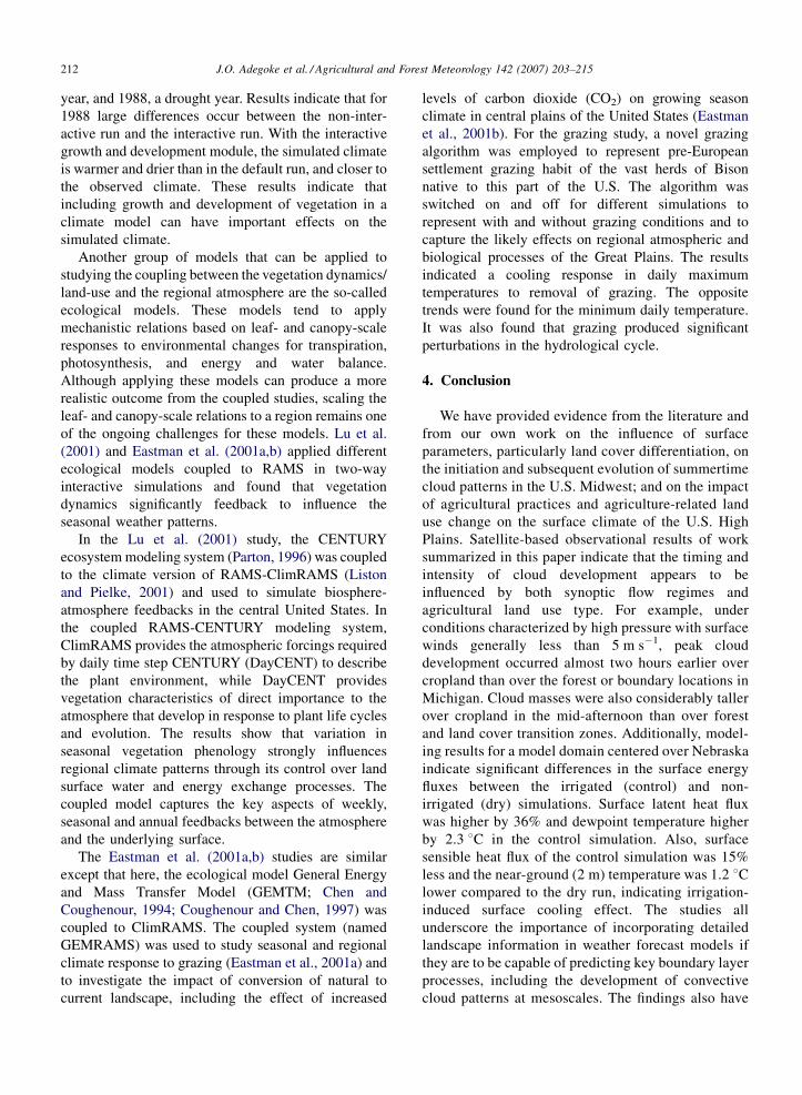
year, and 1988, a drought year. Results indicate that for
1988 large differences occur between the non-inter-
active run and the interactive run. With the interactive
growth and development module, the simulated climate
is warmer and drier than in the default run, and closer to
the observed climate. These results indicate that
including growth and development of vegetation in a
climate model can have important effects on the
simulated climate.
Another group of models that can be applied to
studying the coupling between the vegetation dynamics/
land-use and the regional atmosphere are the so-called
ecological models. These models tend to apply
mechanistic relations based on leaf- and canopy-scale
responses to environmental changes for transpiration,
photosynthesis, and energy and water balance.
Although applying these models can produce a more
realistic outcome from the coupled studies, scaling the
leaf- and canopy-scale relations to a region remains one
of the ongoing challenges for these models. Lu et al.
(2001) and Eastman et al. (2001a,b) applied different
ecological models coupled to RAMS in two-way
interactive simulations and found that vegetation
dynamics significantly feedback to influence the
seasonal weather patterns.
In the Lu et al. (2001) study, the CENTURY
ecosystem modeling system (Parton, 1996) was coupled
to the climate version of RAMS-ClimRAMS (Liston
and Pielke, 2001) and used to simulate biosphere-
atmosphere feedbacks in the central United States. In
the coupled RAMS-CENTURY modeling system,
ClimRAMS provides the atmospheric forcings required
by daily time step CENTURY (DayCENT) to describe
the plant environment, while DayCENT provides
vegetation characteristics of direct importance to the
atmosphere that develop in response to plant life cycles
and evolution. The results show that variation in
seasonal vegetation phenology strongly influences
regional climate patterns through its control over land
surface water and energy exchange processes. The
coupled model captures the key aspects of weekly,
seasonal and annual feedbacks between the atmosphere
and the underlying surface.
The Eastman et al. (2001a,b) studies are similar
except that here, the ecological model General Energy
and Mass Transfer Model (GEMTM; Chen and
Coughenour, 1994; Coughenour and Chen, 1997) was
coupled to ClimRAMS. The coupled system (named
GEMRAMS) was used to study seasonal and regional
climate response to grazing (Eastman et al., 2001a) and
to investigate the impact of conversion of natural to
current landscape, including the effect of increased
levels of carbon dioxide (CO2) on growing season
climate in central plains of the United States (Eastman
et al., 2001b). For the grazing study, a novel grazing
algorithm was employed to represent pre-European
settlement grazing habit of the vast herds of Bison
native to this part of the U.S. The algorithm was
switched on and off for different simulations to
represent with and without grazing conditions and to
capture the likely effects on regional atmospheric and
biological processes of the Great Plains. The results
indicated a cooling response in daily maximum
temperatures to removal of grazing. The opposite
trends were found for the minimum daily temperature.
It was also found that grazing produced significant
perturbations in the hydrological cycle.
4. Conclusion
We have provided evidence from the literature and
from our own work on the influence of surface
parameters, particularly land cover differentiation, on
the initiation and subsequent evolution of summertime
cloud patterns in the U.S. Midwest; and on the impact
of agricultural practices and agriculture-related land
use change on the surface climate of the U.S. High
Plains. Satellite-based observational results of work
summarized in this paper indicate that the timing and
intensity of cloud development appears to be
influenced by both synoptic flow regimes and
agricultural land use type. For example, under
conditions characterized by high pressure with surface
winds generally less than 5 m s�1, peak cloud
development occurred almost two hours earlier over
cropland than over the forest or boundary locations in
Michigan. Cloud masses were also considerably taller
over cropland in the mid-afternoon than over forest
and land cover transition zones. Additionally, model-
ing results for a model domain centered over Nebraska
indicate significant differences in the surface energy
fluxes between the irrigated (control) and non-
irrigated (dry) simulations. Surface latent heat flux
was higher by 36% and dewpoint temperature higher
by 2.3 8C in the control simulation. Also, surface
sensible heat flux of the control simulation was 15%
less and the near-ground (2 m) temperature was 1.2 8Clower compared to the dry run, indicating irrigation-
induced surface cooling effect. The studies all
underscore the importance of incorporating detailed
landscape information in weather forecast models if
they are to be capable of predicting key boundary layer
processes, including the development of convective
cloud patterns at mesoscales. The findings also have

J.O. Adegoke et al. / Agricultural and Forest Meteorology 142 (2007) 203–215 213
significance in gaining understanding of the feedback
of human modifications to the landscape and climate.
Furthermore, very useful insights on crop–climate
interactions have emerged from recent studies based on
coupling crop models to regional climate models.
Incorporating the important perturbations such as
prolonged droughts and the resulting changes in soil
and plant nutrient conditions remains one of the biggest
challenges in developing these couplings. The inter-
active feedbacks that have been studied over mid-
latitude regions will be significantly different in other
ecoregions, particularly in the more arid parts of the
world. Moreover, most of the ecological models
generally fail to reproduce the extreme environment
(e.g., very dry or very wet soil and atmospheric
humidity) satisfactorily, and therefore, model simula-
tions are prone to higher levels of uncertainty when
assessing the sensitivity of the different agriculture-
related environmental forcings on regional climate (see
Pielke et al., 2003 for a detailed discussion of these
challenges and uncertainties). Further, the ability to
provide more realistic vegetation changes as boundary
conditions significantly improves the model perfor-
mance. Thus, it may not be as much a choice of model,
but the representation of the correct regional drivers that
could be the critical factor. Finally, because crop models
tend to operate at the field/plot spatial scale while
regional climate models are typically applied to spatial
domains with horizontal lengths of a few kilometre to
100–200 km, the task of developing adequate proce-
dures to address this spatial scale disparity is not trivial.
It is important to realize that no single model can
completely simulate the local, regional, and continental
vegetation dynamics, and efforts are needed to compare
the different modeling approaches with the observed
vegetation dynamics over the various agro-climatic
regimes.
Acknowledgements
The results discussed here are based on studies
supported by various grants and contracts including the
USGS EROS Data Center Contract 1434-CF-97-AG-
00025 and National Science Foundation Grants
(DEB9632852 and ATM 98-76753). The support of
the Earth System Science Center (now Earth and
Environmental Systems Institute), Pennsylvania State
University and Cooperative Institute for Research in the
Atmosphere (CIRA), Colorado State University via
research and postdoctoral fellowships to J. O. Adegoke
are gratefully acknowledged.
References
Adegoke, J.O., 2000. Satellite-based investigation of land surface-
climate interactions in the United States Midwest. Ph.D. disserta-
tion. The Pennsylvania State University, 162 pp.
Adegoke, J.O., Carleton, A.M., 2000. Warm season land surface—
climate interactions in the United States Midwest from mesoscale
observations. In: McLaren, S., Kniveton, D. (Eds.), Linking
Climate to Land Surface Change. Kluwer Academic Publishers,
Dordrecht, pp. 83–97.
Adegoke, J.O., Carleton, A.M., 2002. Satellite vegetation index-soil
moisture relations in the US ‘‘Corn Belt’’. J. Hydrometeorol. 3,
395–405.
Adegoke, J.O., Pielke Sr., R.A., Eastman, J., Mahmood, R., Hubbard,
K.G., 2003. A regional atmospheric Model study of the impact of
irrigation on midsummer surface energy budget in the U.S. High
Plains. Monthly Weather Rev. 131 (3), 556–564.
Alpert, P., Mandel, M., 1986. Wind variability—an indicator for
mesoclimatic change in Israel. J. Clim. Appl. Meteor. 25,
1568–1576.
Anthes, R.A., 1984. Enhancement of convective precipitation by
mesoscale variations in vegetative covering in semiarid regions.
J. Clim. Appl. Meteor. 23, 541–554.
Barnston, A.G., Schickendanz, P.T., 1984. The effect of irrigation on
warm season precipitation in the southern Great Plains. J. Clim.
Appl. Meteor. 23, 865–888.
Betts, A.K., Ball, J.H., 1994. Budget Analysis of FIFE 1987 Sonde
data. J. Geophys. Res. 99, 3655–3666.
Betts, A.K., Ball, J.M., Beljaars, A.C.M., Miller, M.J., Viterbo, P.,
1994. Coupling between land-surface boundary-layer parameter-
ization and rainfall on local and regional scales: lessons from the
wet summer of 1993. In: Preprints, Fifth Conference on Global
Change Studies. Amer. Meteor. Soc., Nashville, TN, pp. 174–181.
Brown, M.E., Arnold, D.L., 1998. Land surface—atmosphere inter-
actions associated with deep convection in Illinois. Int. J. Climatol.
18 (15), 1637–1655.
Carleton, A.M., O’Neal, M., 1995. Satellite-derived land surface
climate ‘‘signal’’ for the Midwest U.S.A. Intl. J. Remote. Sens.
16, 3195–3202.
Carleton, A.M., Jelinski, D., Travis, D., Arnold, D., Brinegar, R.,
Easterling, D., 1994. Climatic-scale vegetation—cloud interactions
during drought using satellite data. Int. J. Climatol. 14, 593–623.
Carleton, A.M., Adegoke, J.O., Allard, J., Arnold, D.L., Travis, D.J.,
2001. Synoptic context of summer season land cover-convective
cloud associations for the Midwest US ‘‘Corn Belt’’. Geophys.
Res. Lett. 28 (9), 1679–1682.
Chang, J.-T., Wetzel, P.J., 1991. Effects of spatial variations of soil
moisture and vegetation on the evolution of a prestorm environment:
a numerical case study. Monthly Weather Rev. 119, 1368–1390.
Chase, T.N., Pielke Sr., R.A., Kittel, T.G.F., Baron, J.S., Stohlgren,
T.J., 1999. Potential impacts on Colorado Rocky Mountain
weather due to land use changes on the adjacent Great Plains.
J. Geophys. Res. 104, 16673–16690.
Chen, D.X., Coughenour, M.B., 1994. GEMTM: A general model for
energy and mass transfer of land surfaces and its application at the
FIFE sites. Agric. For. Meteor. 68, 145–171.
Clark, C.A., Arritt, R.W., 1995. Numerical simulations of the effect of
soil moisture and vegetation cover on the development of deep
convection. J. Appl. Meteorol. 34, 2029–2045.
Coughenour, M.B., Chen, D.X., 1997. Assessment of grassland
ecosystem responses to atmospheric change using linked plant–
soil process models. Ecol. Appl. 7, 802–827.

J.O. Adegoke et al. / Agricultural and Forest Meteorology 142 (2007) 203–215214
De Ridder, K., Galle’e, H., 1998. Land surface-induced regional
climate change in southern Israel. J. Appl. Meteor. 37, 1470–1485.
Easterling, D.R., 1989. Regionalization of thunderstorm rainfall in the
contiguous U.S. Int. J. Climatol. 9, 567–579.
Eastman, J.L., Coughenour, M.B., Pielke Sr., R.A., 2001a. Does
grazing affect regional climate? J. Hydrometeorol. 2, 243–253.
Eastman, J.L., Coughenour, M.B., Pielke Sr., R.A., 2001b. The effects
of CO2 and landscape change using a coupled plant and meteor-
ological model. Global Change Biol. 7, 797–815.
Fritsch, J.M., Kane, R.J., Chelius, C.R., 1986. The contribution of the
mesoscale convective weather systems to the warm-season pre-
cipitation of the United States. J. Appl. Meteor. 25, 1333–1345.
Garand, L., 1988. Automated recognition of oceanic cloud patterns I:
Methodology and application to cloud climatology. J. Clim. 1, 20–
39.
Grell, G.A., Dudhia, J.F., Stauffer, D., 1993. A description of the fifth
generation Penn State/NCAR Mesoscale Model (MM5). NCAR
Tech. Note NCAR/TN-3981IA, 107 pp. (available from National
Center for Atmospheric Research, P.O. Box 3000, Boulder, CO
80307-3000).
Hanesiak, J.M., Raddatz, R.L., Lobban, S., 2004. Local initiation of
deep convection on the Canadian Prairie Provinces. Bound. Layer
Meteor. 110 (3), 455–470.
Iverson, L.R., Risser, P.G., 1987. Analyzing long-term changes in
vegetation using geographic information systems and remotely
sensed data. Adv. Space Res. 7, 183–194.
Kalnay, E., Kanamitsu, M., Kistler, R., Collins, W., Deaven, D.,
Gandin, L., Iredell, M., Saha, S., White, G., Woollen, J., Zhu,
Y., Leetmaa, A., Reynolds, B., Chelliah, M., Ebisuzaki, W.,
Higgins, W., Janowiak, J., Mo, K.C., Ropelewski, C., Wang, J.,
Jenne, R., Joseph, D., 1996. The NCEP/NCAR 40-Year Reanalysis
Project. Bull. Amer. Meteor. Soc. 77, 437–471.
Liston, G.E., Pielke Sr., R.A., 2001. A climate version of the regional
atmospheric modeling system. Theor. Appl. Climatol. 68, 155–173.
Lu, L., Pielke Sr., R.A., Liston, G.E., Parton, W.J., Ojima, D., Hart-
man, M., 2001. Implementation of a two-way interactive atmo-
spheric and ecological model and its application to the central
United States. J. Clim. 14, 900–919.
Mahmood, R., Hubbard, K.G., 2002. Anthropogenic land use change
in the North American tall grass-short grass transition and mod-
ification of near-surface hydrologic cycle. Clim. Res. 21, 83–90.
Mahmood, R., Hubbard, K.G., Carlson, C., 2004. Modification of
growing-season surface temperature records in the Northern Great
Plains due to land use transformation: verification of modeling
results and implication for global climate change. Int. J. Climatol.
24 (3), 311–327.
Marotz, G.A., Clark, J., Henry, J., Standfast, R., 1975. Cloud fields
over irrigated areas in southwestern Kansas—data and specula-
tions. Prof. Geogr. 27, 457–461.
McPherson, R., Stensrud, D., Crawford, K.C., 2004. The impact of
Okalhoma’s winter wheat belt on the mesoscale environment.
Monthly Weather Rev. 132 (2), 405–421.
Moller, A.R., Doswell III, C.A., Foster, M.P., Woodall, G.R., 1994.
The operational recognition of supercell thunderstorm environ-
ments and storm structures. Wea. Forecasting 9, 327–347.
National Agricultural Statistics Service, 1998. Crop values: final
estimates by states, 1992–97; 2002. Statistical Bull. Agricultural
Statistics Board, U.S. Department of Agriculture, p. 963 (available
online).
O’Neal, M., 1996. Interactions between land cover and convective
cloud cover over Midwestern North America detected from GOES
satellite data. Int. J. Remote Sens. 17, 1149–1181.
Pan, Z., Takle, E., Segal, M., Arritt, R., 1999. Simulation of potential
impacts of man-made land use changes on U.S. summer climate
under various synoptic regimes. J. Geophys. Res. 104 (D6), 6515–
6528, doi:10.1029/98JD02310.
Parton, W.J., 1996. The CENTURY model. In: Powlson, D.S.,
Smith, P., Smith, J.U. (Eds.), Evaluation of Soil Organic Matter
Models, NATO ASI Series, vol. 13. Springer-Verlag, pp. 283–
291.
Pielke Sr., R.A., Zeng, X., 1989. Influence on severe storm develop-
ment of irrigated land. Nat. Wea. Dig. 14, 16–17.
Pielke Sr., R.A., Avissar, R., 1990. Influence of landscape structure on
local and regional climate. Landsc. Ecol. 4, 133–155.
Pielke Sr., R.A., Dalu, G.A., Snook, J.S., Lee, T.J., Kittel, T.G.F.,
1991. Nonlinear influence of mesoscale land use on weather and
climate. J. Clim. 4, 1053–1069.
Pielke Sr., R.A., 2001. Influence of the spatial distribution of vegeta-
tion and soils on the prediction of cumulus convective rainfall.
Rev. Geophys. 39, 151–177.
Pielke Sr., R.A., Dutta, D., Niyogi, S., Chase, T.N., Eastman, J.L.,
2003. A new perspective on climate change and variability: a focus
on India. Proc. Indian Natl. Sci. Acad. 69 (5), 585–602.
Rabin, R.M., Stadler, S.J., Wetzel, P.J., Stensrud, D.J., Gregory, M.,
1990. Observed effects of landscape variability on convective
clouds. Bull. Am. Meteor. Soc. 71, 272–280.
Rabin, R.M., Martin, D.W., 1996. Satellite observations of shallow
cumulus coverage over the central United States: an exploration
of land use impact on cloud cover. J. Geophys. Res. 101, 7149–
7155.
Raymond, W.H., Rabin, R.M., Wade, G.S., 1994. Evidence of an
agricultural heat island in the lower Mississippi river floodplain.
Bull. Am. Meteor. Soc. 75, 1019–1025.
Samson, F., Knopf, F., 1994. Prairie conservation in North America.
Bioscience 44 (6), 418–421.
Segal, M., Avissar, R., McCumber, M.C., Pielke, R.A., 1988. Evalua-
tion of vegetation effects on the generation and modification of
mesoscale circulations. J. Atmos. Sci. 45, 2268–2292.
Segal, M., Arritt, R.W., Clark, C., Rabin, R., Brown, J., 1995. Scaling
evaluation of the effect of surface characteristics on potential for
deep convection over uniform terrain. Monthly Weather Rev. 123,
383–400.
Segal, M., Pan, Z., Turner, R.W., Takle, E.S., 1998. On the potential
impact of irrigated areas in North American summer rainfall
caused by large-scale systems. J. Appl. Meteor. 37, 325–331.
Stohlgren, T.J., Chase, T.N., Pielke Sr., R.A., Kittel, T.G.F., Baron, J.,
1998. Evidence that local land use practices influence regional
climate and vegetation patterns in adjacent natural areas. Global
Change Biol. 4, 495–504.
Sparks, J., Changnon, D., Starke, J., 2002. Changes in the frequency of
extreme warm-season surface dew points in northeastern Illinois.
Implications for cooling-system design and operation. J. Appl.
Meteor. 41, 890–898.
Tsvetsinskaya, E., Mearns, L.O., Easterling, W., 2001a. Investigating
the effect of seasonal plant growth and development in 3-dimen-
sional atmospheric simulations. Part I: Simulation of surface
fluxes over the growing season. J. Clim. 14, 692–709.
Tsvetsinskaya, E., Mearns, L.O., Easterling, W., 2001b. Investigating
the effect of seasonal plant growth and development in 3-dimen-
sional atmospheric simulations. Part II: Atmospheric response to
crop growth and development. J. Clim. 14, 711–729.
Travis, D.J., 1997. An investigation of Wisconsin’s anthropogenically-
generated convergence boundary and possible influences on cli-
mate. Wisconsin Geogr. 12, 34–46.

J.O. Adegoke et al. / Agricultural and Forest Meteorology 142 (2007) 203–215 215
Walko, R.L., Tremback, C.J., Pielke Sr., R.A., Cotton, W.R., 1995. An
interactive nesting algorithm for stretched grids and variable
nesting ratios. J. Appl. Meteor. 34, 994–999.
Walko, R.L., Band, L.E., Baron, J., Kittel, T.G.F.,Lammers, R., Lee,T.J.,
Ojima, D., Pielke Sr., R.A., Taylor, C., Tague, C., Tremback, C.J.,
Vidale, P.L., 2000. Coupled atmosphere–biophysics–hydrology
models for environmental modeling. J. Appl. Meteor. 39, 931–944.
Weaver, C.P., Avissar, R., 2001. Atmospheric disturbances caused by
human modification of the landscape. Bull. Am. Meteor. Soc. 82
(2), 269–281.
Wetzel, P.J., 1990. A simple parcel method for prediction of cumulus
onset and area-averaged cloud amount over heterogeneous land
surfaces. J. Appl. Meteor. 29, 516–523.
Wetzel, P.J., Argentini, S., Boone, A., 1996. Role of land surface in
controlling daytime cloud amount: two case studies in the GCIP-
SW area. J. Geophys. Res. 101, 7359–7370.
Winkler, J.A., Skeeter, B.R., Yamamoto, P.D., 1988. Seasonal
variations in the diurnal characteristics of heavy hourly pre-
cipitation across the United States. Mon. Wea. Rev. 116, 1641–
1658.