ModelBuilder In ArcGIS 9.x By Tim Weigel GEOG 407/607 April 3 rd, 2006.
20
ModelBuilder In ArcGIS 9.x By Tim Weigel GEOG 407/607 April 3 rd , 2006
-
date post
21-Dec-2015 -
Category
Documents
-
view
217 -
download
1
Transcript of ModelBuilder In ArcGIS 9.x By Tim Weigel GEOG 407/607 April 3 rd, 2006.
ModelBuilderIn
ArcGIS 9.x
ByTim Weigel
GEOG 407/607
April 3rd, 2006

Outline
• What is a model?
• Why create a model?
• How to create a model.
• How to edit a model.
• Documenting your model.
• Run a demo.

Geoprocessing
• Geoprocessing
A set of tools within a GIS which are necessary for the management, conversion or analysis of spatial information.
- GIS operations used to manipulate data stored in a GIS workspace.
Data Management
Projections Spatial Analysis
Buffer
Clip
Union
Data Conversion
.e00 coverage
shapefilecoverage
coverage.dwg

Accessing Geoprocessing Tools
• Four Ways
ArcToolbox
Command Line
Python Script
Model Builder
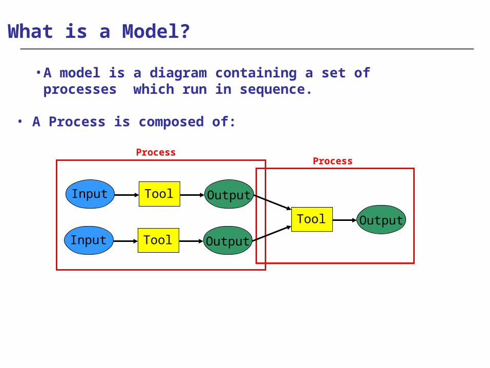
ProcessProcess
Input
Input
What is a Model?
• A model is a diagram containing a set of processes which run in sequence.
Tool
Tool
Tool
Output
Output
Output
• A Process is composed of:

Why Create A Model?
• Creating a model:
– Helps to automate geoprocessing workflow.
– Helps reduce time by stringing multi-step tasks into a single process.
– Creates custom tools that can be ran multiple times.
– Provides visual representation and documentation of the geoprocessing workflow for those using the models.

Creating A Model Using ModelBuilder
• Model builder window
• Access through custom toolbox

Model Elements
ProjectData
Project data or Input data already exists prior to the model
Connectorsconnect data to tools and populate parameters
Tools
Tools can be of two types: SystemorCustom
DerivedData
Derived data or Output data can be used as input into another process or as the termination of your model
Process

Model States
ProjectData
ToolsDerived
Data
• Not Ready To Run
ProjectData
ToolsDerived
Data
• Ready To Run
ProjectData
ToolsDerived
Data
• Successfully Run
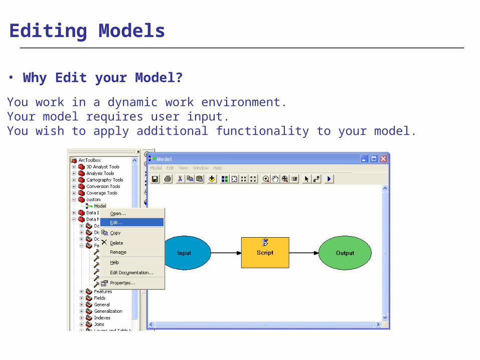
Editing Models
• Why Edit your Model?
- You work in a dynamic work environment.- Your model requires user input.- You wish to apply additional functionality to your model.

Editing Functions
• Parameters and Variables
- Are required or optional values within geoprocessing tools.- Allows for greater user input.- Can be either a system tool parameter or a model parameter

Editing Functions
• Intermediate Data
- Data that is generated while running your model but is not the final product of your model.
- All derived data is considered intermediate.- Consider checking off the intermediate status of your final
derived data.

• Validate Model
Editing Functions
- Ensures that all parameters and variables are valid.- Ensures that all data and tools are present and working
properly.

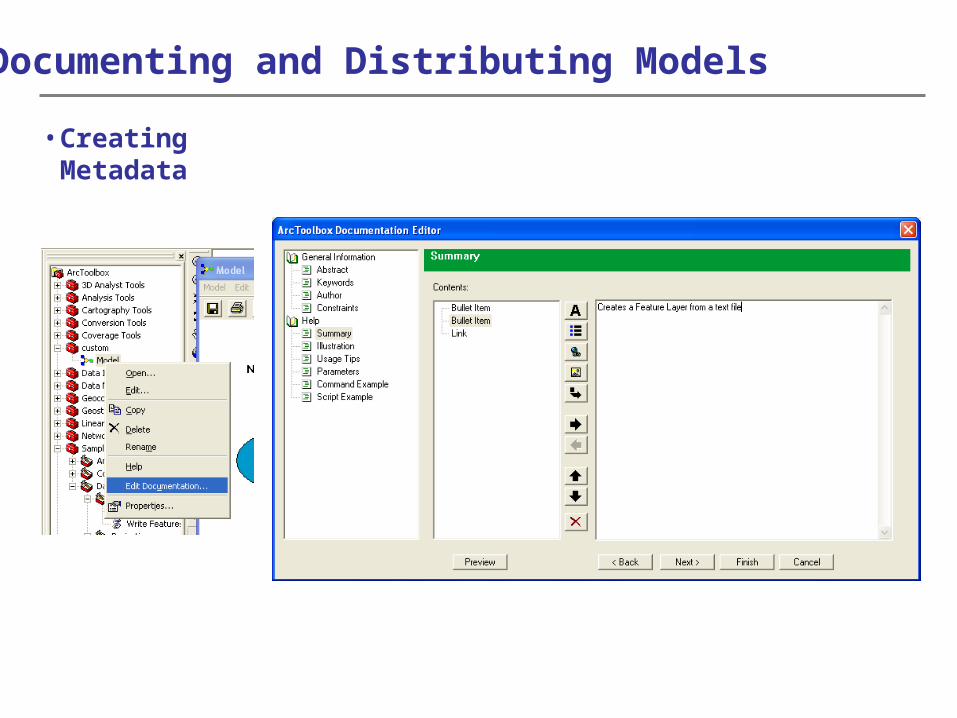
Documenting and Distributing Models
• Adding Documentation to your model provides descriptive information to the user about the process they are about to run.
• Labeling- Two kinds of labels
- Stand alone- Element labels

Documenting and Distributing Models
• Documenting Map Elements
Documenting and Distributing Models
• Creating Metadata

Documenting and Distributing Models
• Viewing and Using Model Reports

Documenting and Distributing Models
• Setting model properties before distributing the model

Documenting and Distributing Models
• Sharing your model
- Custom toolboxes are stored as either standalone .tbx files or in a geodatabase.
- .tbx files are sharable and can be emailed.- Make sure to set your toolbox for read/write access.

Demo