MACC VALIDATION PROTOCOL Iss1Rev0 11.10.2010 to authorities and policy makers receives a particular...
47
PROJECT: SUB-PROJECT / CLUSTER: WORK PACKAGE / TASK: DELIVERABLE: MACC Monitoring Atmospheric Composition and Climate MAN Management and System Engineering MAN_3 System engineering for the GMES Atmospheric Service D_MAN_3.4 Validation Protocol Issue 1 11.10.2010
Transcript of MACC VALIDATION PROTOCOL Iss1Rev0 11.10.2010 to authorities and policy makers receives a particular...

PROJECT: SUB-PROJECT / CLUSTER: WORK PACKAGE / TASK: DELIVERABLE:
MACC Monitoring Atmospheric Composition and Climate MAN Management and System Engineering MAN_3 System engineering for the GMES Atmospheric Service D_MAN_3.4
Validation Protocol
Issue 1
11.10.2010

EC FP7 – MACC
Validation Protocol
REF. : FP7-MACC-MAN-3-4ISSUE : 1 REVISION: 0 DATE : 11.10.2010 PAGE : 2 of 47
THIS PAGE INTENTIONALLY LEFT BLANK

EC FP7 – MACC
Validation Protocol
REF. : FP7-MACC-MAN-3-4ISSUE : 1 REVISION: 0 DATE : 11.10.2010 PAGE : 3 of 47
title / titre MACC Validation Protocol author / auteur Jean-Christopher Lambert (IASB-BIRA) reference / référence FP7-MACC-MAN-3-4 issue / édition 1 revision / révision 0 status / état final date of issue / date d’édition 11.10.2010 document type / type de document Framework/Management Document
FUNCTION NAME DATE
AUTHOR
GAS System Engineering J.-C. Lambert (IASB-BIRA) 11.10.2010
REVIEWED BY MANAGEMENT AND OUTREACH REVIEWED AND ENDORSED BY SERVICE LEADERS
MACC Project Coordinator GAS System Engineering Outreach Cluster
O-INTERFACE to end usersO-POL Support of policy
Global Cluster
G-GHG Greenhouse GasesG-RG Reactive Gases
G-AER Global AerosolsG-IDAS Integrated Data Assimilation Regional Cluster
R-EDA Air Quality AssimilationR-ENS Ensemble AQ Forecast
R-EVA Air Quality EvaluationR-RAD Solar Radiation
Input Data Cluster D-INSITU In situ data provisionD-SAT Satellite data provision
D-EMIS Anthropogenic EmissionsD-FIRE FireeEmissions
A. Simmons (ECMWF) A. De Rudder (IASB-BIRA)
T. Holzer-Popp (DLR) Ø. Hov (MET.NO)
F. Chevallier (IPSL-LSCE) M. Schultz (FZJ) O. Boucher (UKMET) R. Engelen (ECMWF) H. Elbern (FRIUUK) V-H. Peuch (MF-CNRM) L. Rouil (INERIS) M. Schroedter-Homscheidt (DLR) L. Wald (Armines) L. Tarrason (NILU) A. Simmons (ECMWF) C. Granier (UPMC-LATMOS) J. Kaiser (ECMWF)
ISSUED BY GAS System Engineering J.-C. Lambert (IASB-BIRA) 11.10.2010

EC FP7 – MACC
Validation Protocol
REF. : FP7-MACC-MAN-3-4ISSUE : 1 REVISION: 0 DATE : 11.10.2010 PAGE : 4 of 47
DOCUMENT CHANGE RECORD
Issue Revision Date Modified Items / Reason for Change
0 0 15.10.2009 Document created
0 1 02.02.2010 Adaptation of PROMOTE 2 C5 Validation Protocol (dated 02.02.2010)
0 3 20.03.2010 Update to QA4EO principles dated 26-29.05.2009
0
0
4
5
28.06.2010
11.10.2010
Provisional issue for review and endorsement (reviewers listed on Page 3)
Reviewed document for approval and official endorsement
1 0 11.10.2010 First public issue

EC FP7 – MACC
Validation Protocol
REF. : FP7-MACC-MAN-3-4ISSUE : 1 REVISION: 0 DATE : 11.10.2010 PAGE : 5 of 47
EXECUTIVE SUMMARY
Monitoring Atmospheric Composition and Climate (MACC) is the EC FP7 project establishing the core global and regional atmospheric environmental service of the European GMES programme. The present MACC Validation Protocol outlines the top-level definition of the approach for validating all constituents of the MACC Product Portfolio. It establishes validation principles that are universally applicable to all products and services, plus specific principles more dedicated to families of services. Established by independent experts in Quality Assessment and geophysical validation on the basis of peer-reviewed documentation, accepted practices and international standards collected from authorised sources, the MACC Validation Protocol is endorsed by the service (sub-project) networks.
This document addresses:
General rules to ensure unbiased, independent and traceable validation
Definition of the tasks of the research partners, system developers, service providers and core users regarding the various aspects of the services and data products validation
Definition of different validation levels and top-level validation criteria, review process and decisions sequence
Requirements for reference data sources and methods
Approach for validating new products, upgrades, long-term quality assurance, endorsement by key external user-bodies, validation of services (as opposed to the validation of products only)
Requirements for appropriate and sustainable validation documentation
Document availability, access and distribution rules
Maintenance of validation standards, reports and data sets.
The validation of each service during its build-up and during it successive updates, is fulfilled by a combination of complementary measures, including the end-to-end validation of individual components of a service chain, the validation of data products and services against specifications, and the validation of data products and services against user requirements.
The material in this document has been subject to technical and policy review by the MACC Management Board and the MACC Sub-project Leaders, and approved for publication with open diffusion. However, the document does not necessarily represent the views and official position of any of the partners and of the European Commission.

EC FP7 – MACC
Validation Protocol
REF. : FP7-MACC-MAN-3-4ISSUE : 1 REVISION: 0 DATE : 11.10.2010 PAGE : 6 of 47
THIS PAGE INTENTIONALLY LEFT BLANK

EC FP7 – MACC
Validation Protocol
REF. : FP7-MACC-MAN-3-4ISSUE : 1 REVISION: 0 DATE : 11.10.2010 PAGE : 7 of 47
TABLE OF CONTENTS
DOCUMENT CHANGE RECORD……………………………………………………… .... …4
EXECUTIVE SUMMARY……………………………………………………………………. .. 5
1. INTRODUCTION .......................................................................................................... 9
1.1 Purpose of this document ............................................................................................................... 9 1.2 Document overview ..................................................................................................................... 10
2. APPLICABLE AND REFERENCE DOCUMENTS ................................................ 11
2.1 Applicable Documents ................................................................................................................. 11 2.1.1 MACC documents ............................................................................................................. 11 2.1.2 INSPIRE legislation ........................................................................................................... 11
2.2 Reference Documents .................................................................................................................. 12 2.2.1 MACC, GEMS and PROMOTE documents ..................................................................... 12 2.2.2 Service specifications (ATBDs, PSDs…).......................................................................... 13 2.2.3 International standards, terms and definitions, framework documents,............................. 13 2.2.4 Validation methods and validation results ......................................................................... 14
3. TERMS AND DEFINITIONS ..................................................................................... 17
3.1 Recommended terminology ......................................................................................................... 17 3.2 Abbreviations and acronyms ........................................................................................................ 21
4. VALIDATION PROTOCOL....................................................................................... 25
4.1 Foreword ...................................................................................................................................... 25 4.2 General principles of the validation of atmospheric services ...................................................... 25
4.2.1 Core requirements of the GEOSS data quality strategy ..................................................... 25 4.2.2 Principles of the validation of atmospheric data ................................................................ 25 4.2.3 Principles of the validation of a service line ...................................................................... 26
4.2.3.1 Confrontation with independent reference data ......................................................... 27 4.2.3.2 Error budget of data comparison ............................................................................... 27 4.2.3.3 Analysis of information content ................................................................................ 29
4.2.4 Validation of individual service components .................................................................... 29 4.2.5 Validation against service specifications ........................................................................... 30 4.2.6 Validation against user requirements ................................................................................. 30 4.2.7 Quality control of services in operation ............................................................................. 30 4.2.8 Validation of service updates ............................................................................................. 30 4.2.9 Service endorsement by key users ..................................................................................... 31
4.3 Specifics of validation of the MACC thematic lines.................................................................... 31 4.3.1 Validation of the air quality services ................................................................................. 31
4.3.1.1 General issues ............................................................................................................ 31 4.3.1.2 Validation of NRT air quality services ...................................................................... 32

EC FP7 – MACC
Validation Protocol
REF. : FP7-MACC-MAN-3-4ISSUE : 1 REVISION: 0 DATE : 11.10.2010 PAGE : 8 of 47
4.3.1.3 Validation of air quality re-analysis service .............................................................. 32 4.3.2 Validation of the atmospheric composition and climate change services.......................... 33 4.3.3 Validation of the UV and solar energy services ................................................................ 34
4.3.3.1 Verification of UV and derived services ................................................................... 34 4.3.3.2 Validation of global and direct irradiance services ................................................... 34
4.3.4 Validation of the stratospheric ozone services ................................................................... 35 4.3.4.1 Records of ozone column and of stratospheric ozone profile .................................... 35 4.3.4.2 Forecast and NRT analyses of the ozone column ...................................................... 36
4.3.5 Emissions from biomass burning ....................................................................................... 36 4.3.6 Validation of aspects related to alerts and fast response .................................................... 37
5. RESPONSIBILITIES ................................................................................................... 38
6. QUALITY CONTROL RULES .................................................................................. 39
6.1 Review process and decision sequence ........................................................................................ 39 6.2 Long-term quality assurance ........................................................................................................ 39 6.3 Principle means of validation ....................................................................................................... 39
6.3.1 Requirements for reference data ........................................................................................ 39 6.3.2 Requirements for comparison methods ............................................................................. 40 6.3.3 Equivalent products and model output in the service portfolio ......................................... 40
6.4 Steps in the validation process ..................................................................................................... 41
7. STANDARDS ................................................................................................................ 42
7.1 Maintenance of datasets and reports ............................................................................................ 42 7.2 Metadata and additional information ........................................................................................... 42 7.3 Quality Control metadata and criteria .......................................................................................... 43 7.4 Quality Assurance breakpoints .................................................................................................... 43 7.5 QA and validation documentation ............................................................................................... 44 7.6 QA and validation metadata ......................................................................................................... 45 7.7 Compliance with international standards ..................................................................................... 47 7.8 Compliance with INSPIRE .......................................................................................................... 47

EC FP7 – MACC
Validation Protocol
REF. : FP7-MACC-MAN-3-4ISSUE : 1 REVISION: 0 DATE : 11.10.2010 PAGE : 9 of 47
1. INTRODUCTION
1.1 Purpose of this document MACC and the GMES Atmospheric Service
Monitoring Atmospheric Composition and Climate (MACC) is establishing the core global and regional atmospheric environmental service of the European GMES programme. It is funded under the Seventh Framework Programme of the European Union and began on 1 June 2009. MACC is undertaken by a consortium drawn largely from the partners in the earlier GEMS and PROMOTE projects, whose core systems and service lines provided the starting point for MACC.
MACC combines state-of-the-art atmospheric modelling with Earth observation data – from satellite and in situ measurement systems – to provide information services covering European Air Quality, Global Atmospheric Composition, Climate, and UV and Solar Energy. It monitors the distributions and long-range transport of greenhouse gases such as carbon dioxide and methane, aerosols, and reactive gases such as tropospheric ozone and nitrogen dioxide. It provides global forecasts of reactive gases and aerosols, as well as detailed forecasts and assessments of air quality in Europe. It also provides records and forecasts of stratospheric ozone, UV radiation and solar energy.
User involvement
A major challenge in the life cycle of a user-oriented service is to provide sound description of the data products and quantification of their uncertainties in order to enable users to assess the suitability of the products to the targeted application, i.e. its “fitness for purpose”. User requirements are collected and user feedback is organised formally through sub-project O-INT. Core user organisations are involved actively in the MACC project via a formal Service Level Agreements (SLA), in which user needs are outlined. Support to authorities and policy makers receives a particular care in sub-project O_POL.
MACC Validation Protocol
The present MACC Validation Protocol defines the top-level approach for validating all constituents of the MACC Product Portfolio. It establishes validation principles that are universally applicable to all products and services, plus specific principles dedicated to families of services. Established by independent experts in Quality Assessment and geophysical validation on the basis of peer-reviewed documentation and internationally accepted practices and standards collected from authorised sources, the MACC Validation Protocol is endorsed by the service (sub-project) networks.
Restrictions and responsibilities
The MACC Validation Protocol has been subject to technical and policy review by the MACC Management Board and the MACC Sub-project Leaders, and approved for publication with open diffusion. However, the document does not necessarily represent the views and official position of any of the partners and of the European Commission. It does not claim to address safety concerns, if any, associated with the use of the MACC data and services. It is the responsibility of the service provider to document appropriately the scope and validity of the data supplied. It is the responsibility of the user to interpret data correctly, to follow appropriate safety and health precautions, and to establish prior to use if reported limitations hinder the product applicability.

EC FP7 – MACC
Validation Protocol
REF. : FP7-MACC-MAN-3-4ISSUE : 1 REVISION: 0 DATE : 11.10.2010 PAGE : 10 of 47
1.2 Document overview This document is organised as follows:
Chapter 1 contains this introduction describing the scope of the document.
Chapter 2 lists applicable and reference documents.
Chapter 3 defines the recommended terminology, abbreviations and acronyms.
Chapter 4 summarises the generic principles of the validation protocol and explains the specifics with regard to validation of the four thematic lines in the MACC Portfolio.
Chapter 5 addresses the responsibilities for the different aspects and tasks of validation.
Chapter 6 details the general principles of quality control rules.
Chapter 7 addresses validation and quality control standards: sustainable archiving and traceability quality of the validation process and of validation results, quality control metadata and criteria, quality assurance breakpoints, and documentation.

EC FP7 – MACC
Validation Protocol
REF. : FP7-MACC-MAN-3-4ISSUE : 1 REVISION: 0 DATE : 11.10.2010 PAGE : 11 of 47
2. APPLICABLE AND REFERENCE DOCUMENTS
2.1 Applicable Documents
2.1.1 MACC documents
Most documents are available via the MACC web site (http://www.gmes-atmosphere.eu)
[AD1] Description Of Work “Monitoring Atmospheric Composition and Climate (MACC) – The pilot core GMES Atmospheric Service”, Seventh Framework Programme, Theme 9: Space, Annex I of Grant agreement no. 218793, 374 pp., 7 May 2009.
[AD2] MACC Product Portfolio, Version 2, 143 pp., 5 July 2009.
[AD3] MACC Deliverable D_O-INT_1.1/1.2/1.3: Holzer-Popp, T., et al., MACC Downstream Services and End User Requirements Document reviewed by users, Version 1.1, August 27, 2010. Available on http://www.gmes-atmosphere.eu/documents/deliverables/o-int/MACC_O-INT_Requirements_Document_v1%201_27082010.pdf
[AD4] MACC Deliverable D_R-RAD_2.2_1: User’s Guide to the SoDa and SOLEMI services - Towards the “solar energy radiation resources MACC-RAD Service”, chapter 3 ‘Users expectations’ and chapter 7 ‘The quality of retrieved irradiances’. Available on http://www.gmes-atmosphere.eu/documents/deliverables/r-rad/D_R-RAD_2.1_1.RAD.MACC.v1.0.pdf
[AD5] MACC Deliverable D_O-INT_2.3: Requirements report on air quality modelling and forecasting in the Mediterranean area.
[AD6] MACC Deliverable D_O-INT_2.8: Requirements report on downscaling of European AQ forecasts to street level using a deterministic approach.
[AD7] MACC Deliverable D_O-INT_2.10: Requirements report from sat-based PM test case.
[AD8] MACC Deliverable D_O-INT_3.3: Requirements report based on space-time correlation of dust (DREAM model), AI (TOMS-OMI) with a number of large scale climatological indexes.
[AD9] MACC Deliverable D_O-INT_1.6/1.7, Holzer-Popp et al., Service Level Agreements: Summary of preparation and signature status – SLAs continued from PROMOTE – Plans for new SLAs, September 30, 2010. Available on http://www.gmes-atmosphere.eu/documents/deliverables/o-int/MACC_SLA_status_30092010.pdf
[AD10] MACC Deliverable D_O-INT_1.9: Signed Service Level Agreements for other services continued within MACC.
[AD11] MACC Deliverable D_MAN_3.7: Service Specification Document.
2.1.2 INSPIRE legislation
[AD12] DIRECTIVE 2007/2/EC OF THE EUROPEAN PARLIAMENT AND OF THE COUNCIL of 14 March 2007 establishing an Infrastructure for Spatial Information in the European Community (INSPIRE). Official Journal of the European Union, 25 April 2007

EC FP7 – MACC
Validation Protocol
REF. : FP7-MACC-MAN-3-4ISSUE : 1 REVISION: 0 DATE : 11.10.2010 PAGE : 12 of 47
(L108, 25/04/2007, P. 1-14). Text available on http://eur-lex.europa.eu/LexUriServ/LexUriServ.do?uri=OJ:L:2007:108:0001:0014:EN:PDF
[AD13] COMMISSION REGULATION (EC) No 1205/2008 of 3 December 2008 implementing Directive 2007/2/EC of the European Parliament and of the Council as regards metadata (Text with EEA relevance). Official Journal of the European Union, 4 December 2008 (L 326, 04/12/2008, P. 0012 – 0030). Text available on http://eur-lex.europa.eu/LexUriServ/LexUriServ.do?uri=OJ:L:2008:326:0012:0030:EN:PDF
[AD14] COMMISSION DECISION of 5 June 2009 implementing Directive 2007/2/EC of the European Parliament and of the Council as regards monitoring and reporting (Text with EEA relevance). Notified under document number C(2009) 4199. Official Journal of the European Union, 11 June 2009 (L148, 11/06/2009, P. 0018-0026). Text available on http://eur-lex.europa.eu/LexUriServ/LexUriServ.do?uri=OJ:L:2009:148:0018:0026:EN:PDF
[AD15] COMMISSION REGULATION (EC) No 976/2009 of 19 October 2009 implementing Directive 2007/2/EC of the European Parliament and of the Council as regards the Network Services. Official Journal of the European Union, 20 October 2009 (L 274, 20/10/2009, P. 0009-0018). Text available on http://eur-lex.europa.eu/LexUriServ/LexUriServ.do?uri=OJ:L:2009:274:0009:0018:EN:PDF
[AD16] COMMISSION REGULATION (EU) No 268/2010 of 29 March 2010 implementing Directive 2007/2/EC of the European Parliament and of the Council as regards the access to spatial data sets and services of the Member States by Community institutions and bodies under harmonised conditions. Official Journal of the European Union, 30 March 2010 (L83, 30/03/2010, P. 8-9). Text available on http://eur-lex.europa.eu/LexUriServ/LexUriServ.do?uri=OJ:L:2010:083:0008:0009:EN:PDF
2.2 Reference Documents
2.2.1 MACC, GEMS and PROMOTE documents
[RD1] MACC Product Portfolio, Version 2, 143 pp., 5 July 2009.
[RD2] MACC requirements documents [AD3] to [AD8].
[RD3] MACC Deliverable D_O-INT_1.6/1.7, Holzer-Popp et al., Service Level Agreements: Summary of preparation and signature status – SLAs continued from PROMOTE – Plans for new SLAs, September 30, 2010. Available on http://www.gmes-atmosphere.eu/documents/deliverables/o-int/MACC_SLA_status_30092010.pdf [AD9].
[RD4] MACC Deliverable D_MAN_3.7: Service Specification Document.
[RD5] GEMS documents where applicable, available from http://gems.ecmwf.int/
[RD6] Lambert, J.-C., PROMOTE 2 Atmospheric Services Validation Protocol. Atmospheric Monitoring Services - Stage 2 of the Earthwatch GMES Services Element, PROMOTE 2, C5, Version 3, 14.10.2009. http://www.oma.be/PROMOTE_validation_office/Service%20Validation%20Protocol.htm
[RD7] PROMOTE 2 Service Validation Report. Atmospheric Monitoring Services - Stage 2 of the Earthwatch GMES Services Element, PROMOTE 2, C6, Version 3, 30.12.2009. http://www.oma.be/PROMOTE_validation_office/Service%20Validation%20Report.htm
EC FP7 – MACC
Validation Protocol
REF. : FP7-MACC-MAN-3-4ISSUE : 1 REVISION: 0 DATE : 11.10.2010 PAGE : 13 of 47
[RD8] PROMOTE Validation website, www.oma.be/PROMOTE_validation_office/
[RD9] De Rudder, A., and J.-C. Lambert, PROMOTE 2 Service Network – INSPIRE Technical note. Atmospheric Monitoring Services - Stage 2 of the Earthwatch GMES Services Element, PROMOTE 2, D4, Version 1, 21 January 2010. http://www.gse-promote.org/docs/INSPIRE_Tech_Note_final.pdf
2.2.2 Service specifications (ATBDs, PSDs…)
Algorithm Theoretical Basis Document (ATBD), Product Specification Document (PSD) etc. from MACC, GEMS and PROMOTE where applicable.
2.2.3 International standards, terms and definitions, framework documents,
[RD10] CDRH: Center for Devices and Radiological Health (CDRH), General Principles of Software Validation; Final Guidance for Industry and FDA Staff, CBER CDRH/OC Doc. N. 938, January 11, 2002. Publicly available via http://www.fda.gov/MedicalDevices/DeviceRegulationandGuidance/
[RD11] CEOS: Committee on Earth Observation Satellites (CEOS): Terms and Definitions and other documents and resources publicly available on http://calvalportal.ceos.org
[RD12] Larssen, S., R. Sluyter, and C. Helmis, Criteria for EUROAIRNET – The EEA Air Quality Monitoring and Information Network, 1999.
[RD13] Nappo, C.J., Caneill J.Y., Furman R.W., Gifford F.A., Kaimal J.C., Kramer M.L., Lockhart T.J., Pendergast M.M, Pielke R.A., Randerson D., Shreffler J.H., and Wyngaard J.C., The Workshop on the Representativeness of Meteorological Observations, June 1981, Boulder, CO, Bull. Am. Meteorol. Soc. 63, 761-764, 1982.
[RD14] NIST: Prokhorov, A. V., R. U. Datla, V. P. Zakharenkov, V. Privalsky, T. W. Humpherys, and V. I. Sapritsky, Spaceborne Optoelectronic Sensors and their Radiometric Calibration. Terms and Definitions. Part 1. Calibration Techniques, Ed. by A. C. Parr and L. K. Issaev, NIST Technical Note NISTIR 7203, March 2005.
[RD15] VIM: Joint Committee for Guides in Metrology (JCGM/WG 2) 200:2008 & ISO/IEC Guide 99-12:2007, International Vocabulary of Metrology – Basic and General Concepts and Associated Terms (VIM), http://www.bipm.org/en/publications/guides/vim.html
[RD16] GUM: Joint Committee for Guides in Metrology (JCGM/WG 1) 100:2008, Evaluation of measurement data – Guide to the expression of uncertainty in a measurement (GUM), http://www.bipm.org/utils/common/documents/jcgm/JCGM_100_2008_E.pdf
[RD17] WMO Quality Management Framework (QMF), home page at http://www.wmo.int/pages/prog/www/QMF-Web/home.html
[RD18] QA4EO – A Quality Assurance framework for Earth Observation, established by the CEOS. It consists of ten distinct key guidelines linked through an overarching document (the QA4EO Guidelines Framework) and more community-specific QA4EO procedures, all available on http://qa4eo.org/documentation.html A short QA4EO "user" guide has been produced to provide background into QA4EO and how one would start implementing it (http://qa4eo.org/docs/QA4EO_guide.pdf)
[RD19] ISO Quality Management Principles available at http://www.iso.org/iso/iso9000-14000/understand/qmp.html

EC FP7 – MACC
Validation Protocol
REF. : FP7-MACC-MAN-3-4ISSUE : 1 REVISION: 0 DATE : 11.10.2010 PAGE : 14 of 47
[RD20] INSPIRE Guidance Document – Good practice in data and service sharing. Published by the European Commission, 26 May 2010. Text available on http://inspire.jrc.ec.europa.eu/documents/Data_and_Service_Sharing/INSPIRE_GoodPractice_%20DataService%20Sharing_v1.pdf
[RD21] NetCDF Climate and Forecast Metadata Convention, http://cf-psmdi.llnl.gov
[RD22] Fahre Vik, A., T. Krognes, S-E. Walker, S. Bjørndalsæter, C. Stoll, T. Bårde, R. Paltiel, and B. Gloslie, ESA Campaign Database (CDB) user manual, NILU Technical Note O-103045, 100 pp., April 2006. http://nadir.nilu.no/cdb/doc/CDB_manual_20060405.pdf
[RD23] INSPIRE: Web portal of the Infrastructure for Spatial Information in the European Community (INSPIRE), http://inspire.jrc.ec.europa.eu , and INSPIRE Geoportal, http://www.inspire-geoportal.eu . The INSPIRE framework includes common Implementing Rules (IR) adopted in the areas of Metadata, Data Specifications, Network Services, Data and Service Sharing, and Monitoring and Reporting.
2.2.4 Validation methods and validation results
Common, acceptable practices in validation and validation results can be found in the following reference documents. They were generated by service networks, by supporting projects with a clear link to GMES development activities, and by external projects without direct link to the GMES Atmospheric Service.
[RD24] ACCENT, Atmospheric Composition Change, the European Network of Excellence, EU FP6 project, home web page at http://www.accent-network.org/
[RD25] ACCENT TROPOSAT-2 (AT-2), Atmospheric Composition Change, the European Network of Excellence – Remote Sensing of Atmospheric Constituents from Space, http://troposat.iup.uni-heidelberg.de/AT2/index.html See AT-2 Book, issued in 2009, including Chapter 7 dedicated to the validation of tropospheric observations from satellites.
[RD26] AERO-SAM, Boundary layer AEROsol characterization from Space by advanced data Assimilation into a tropospheric chemistry transport Model, DFG-Project (October 2004 – November 2007)
[RD27] AGAGE, Advanced Global Atmospheric Gases Experiment network, funded partly by NASA in the US and partly by the governments of Australia, United Kingdom and Japan, home web page at http://agage.eas.gatech.edu/
[RD28] ASSET, Assimilation of Envisat data, EU FP5 project, home web page at http://darc.nerc.ac.uk/asset/
[RD29] ASTHMA, Advanced system of teledetection for healthcare. Management of asthma, service home web page at http://www.enviport.com/cgi-bin/exe.pl?asthma&en&asthma&0
[RD30] ASTM International – Standards Worldwide (ASTM), home page at http://www.astm.org
[RD31] Atmospheric Water Vapour Literature Database on http://www.watervapour.org
[RD32] Axe Santé-Environnement, Etudes et Recherche en Pathologies de l'Université de Rouen (ERPUR), service home web page at http://www.univ-rouen.fr/79479574/0/fiche_UFM__pagelibre/
EC FP7 – MACC
Validation Protocol
REF. : FP7-MACC-MAN-3-4ISSUE : 1 REVISION: 0 DATE : 11.10.2010 PAGE : 15 of 47
[RD33] BASCOE, Belgian Assimilation System of Chemical Observations from ENVISAT, service home web page at http://bascoe.oma.be/
[RD34] BILRUSIA, Aerosol modelling, Belgian national funded project
[RD35] CHEOPS-GOME, Climatology of Height-resolved Earth Ozone and Profiling Systems for GOME, ESA project, web page at http://nnorsy.zsw-bw.de/GOME.html
[RD36] COPS, model assimilation of EO & ground-based data (ESA)
[RD37] COST726, Long term changes and climatology of UV radiation over Europe, EU Cost Actions, home web page at http://i115srv.vu-wien.ac.at/uv/COST726/Cost726.htm
[RD38] COST728, Meso-scale meteorological modelling for air pollution and dispersion application, EU Cost Actions, home web page at http://www.cost728.org/
[RD39] COST Action ES0604, Water Vapour in the Climate System (WaVaCS), COST web page at http://cost.esf.org/index.php?id=205&action_number=ES0604, WaVaCS web page at http://www.isac.cnr.it/wavacs/
[RD40] CREATE/DAEDALUS, Construction, use and delivery of a European aerosol database/ Delivery of AErosol proDucts for Assimilation and environmentaL Use, EU FP5 project, home web page at http://loacli.univ-lille1.fr/Daedalus/Daedalus/index.html
[RD41] DOMINO, Derivation of Ozone Monitoring Instrument tropospheric NO2 in near-real time, 2004-2005, funded by the Dutch NIVR, home web page at http://www.knmi.nl/~eskes/projects/domino.html
[RD42] ENVIRONMENT & HEALTH, long-term high resolution AQ simulation, Belgian national funded project
[RD43] EVERGREEN, EnVisat for Environmental Regulation of GREENhouse gases, EU FP5 project, home web page at http://www.knmi.nl/evergreen/
[RD44] EXUPERY, SO2 algorithm development for GOME-2, monitoring volcanic plumes, BMBF-Geotechnologien
[RD45] FAIRMODE – Forum for Air Quality Modelling in Europe http://fairmode.ew.eea.europa.eu/fol429189/forums-guidance/fol404948/guidance-document/Model_guidance_document_v5_1a.pdf
[RD46] GAW, Global Atmosphere Watch, http://www.wmo.ch/web/arep/gaw/gaw_home.html
[RD47] GEOmon, Global Earth Observation and Monitoring of the Atmosphere, EU FP6 Integrated Project, home web page at http://www.geomon.eu
[RD48] GlobAER, A unified, global aerosol dataset from MERIS, (A)ATSR and SEVIRI, ESA Data User Element programme, home web page at http://www.globaerosol.info/
[RD49] Huijnen, V., H. Eskes, J. Marshall, D. Ceburnis, A. Gross, M. Schulz, P. Agnew, S. Kinne, and A. Ghelli, Scoring approaches for the GEMS project, FP6 GEMS-VAL deliverable D_VAL_1.1, 16 pp., June 2008.
[RD50] IMACCO, Virtual institute for Inverse Modelling of the Atmospheric Chemical Composition, home web page at http://www.fz-juelich.de/icg/icg-ii/imacco/
[RD51] ISSI Working Group on Atmospheric Water Vapour web page at http://www.iapmw.unibe.ch/research/projects/issi/

EC FP7 – MACC
Validation Protocol
REF. : FP7-MACC-MAN-3-4ISSUE : 1 REVISION: 0 DATE : 11.10.2010 PAGE : 16 of 47
[RD52] KOPRA project on integrated modelling of particulate matter in Finland, service home web page at http://www.ymparisto.fi/default.asp?node=12463&lan=en
[RD53] MESOR, Beyer H. G., Martinez J. P., Suri M., Torres J. L., Lorenz E., Hoyer-Klick C., Ineichen P., 2008. D 1.1.1 Handbook on Benchmarking, Management and Exploitation of Solar Resource Knowledge, MESOR project, EU FP7 CA – Contract No. 038665. Document available on project web site at http://www.mesor.org/deliverables.html
[RD54] MUSTI, Belgian AQ forecast
[RD55] NDACC, Network for the Detection of Atmospheric Composition Change, home web page at http://www.ndacc.org; formerly the NDSC, Network for the Detection of Stratospheric Change (till 2005); sub-menu “NDACC Publications” contains lists of reference papers addressing and illustrating the comparison of measurements by satellites, FTIR spectrometers, UV-visible spectrometers, UV spectrophotometers, sondes, lidar, microwave radiometers, and UV spectroradiometers.
[RD56] NDACC Satellite Working Group web site at http://accsatellites.aeronomie.be
[RD57] NDMS, Network for the Detection of Mesopause Change, home web page at http://wdc.dlr.de/ndmc/pags/ndmc-1-home.html
[RD58] NOVAC, Network for Observation of Volcanic and Atmospheric Change, EC-funded project, home page at http://www.novac-project.eu/
[RD59] O3M-SAF, Satellite Application Facility on Ozone and Atmospheric Chemistry Monitoring, home web page at http://o3msaf.fmi.fi
[RD60] OMIVAL, Validation of OMI surface UV data, Finish national funded project, poster at http://www.biospherical.com/nsf/.%5Cpresentations%5CAGU2005_poster_OMUVB2.pdf
[RD61] QUITSAT, Air quality assessment through the fusion of EO, ground-based & modeling data, Italian project of ASI Italian Space Agency, http://www.cgspace.it/index.php?option=com_content&task=view&id=345&Itemid
[RD62] SCOUT-O3, Stratospheric-Climate Links with Emphasis on the Upper Troposphere and Lower Stratosphere, EU FP6 project, home web page at http://www.ozone-sec.ch.cam.ac.uk/scout_o3/
[RD63] SOGE, System for Observation of Halogenated Greenhouse Gases in Europe, part of the cluster of five EU funded projects for Global Atmospheric Observations (GATO), home web page at http://www.nilu.no/soge/
[RD64] SPARC-CCMVal, Chemistry-Climate Model Validation Activity for SPARC (Stratospheric processes and their role in Climate), home web page at http://www.pa.op.dlr.de/CCMVal/
[RD65] TEMIS, Tropospheric Emission Monitoring Internet Service, ESA/ESRIN DUP-II project, home web page at http://www.temis.nl/

EC FP7 – MACC
Validation Protocol
REF. : FP7-MACC-MAN-3-4ISSUE : 1 REVISION: 0 DATE : 11.10.2010 PAGE : 17 of 47
3. TERMS AND DEFINITIONS
3.1 Recommended terminology
In Table 1 terms and definitions as recommended by standards development organisations of international recognition have been transcripted from reference documents [RD10] to [RD18] (Section 2.2.3). In some cases terms and definitions peculiar to MACC are proposed. They are expected to evolve as these organisations regularly update their standards and as further standardisation and harmonisation occur.
Table 1 – Recommended terms and definitions
TERM DEFINITION SOURCE
accuracy closeness of agreement between a quantity value obtained by measurement and the true value of the measurand; note that it is not a quantity and it is not given a numerical quantity value
VIM, GUM
area (volume) of representativeness
the area (volume) in which the concentration does not differ from the concentration at the station by more than a specific range
Larssen
bias
(1) systematic error of indication of a measuring system
(2) estimate of a systematic measurement error
(3) estimate of a systematic forecast error
VIM
VIM
MACC
calibration
(1) the process of quantitatively defining the system responses to known, controlled signal inputs
(2) operation that, under specified conditions, in a first step, establishes a relation between the quantity values with measurement uncertainties provided by measurement standards and corresponding indications with associated measurement uncertainties and, in a second step, uses this information to establish a relation for obtaining a measurement result from an indication
CEOS VIM
dead band (or neutral zone)
maximum interval through which a value of a quantity being measured can be changed in both directions without producing a detectable change in the corresponding indication
VIM
detection limit
measured quantity value, obtained by a given measurement procedure, for which the probability of falsely claiming the absence of a component, given a probability α of falsely claiming its presence
VIM
error
(1) measured quantity value minus a reference quantity value
(2) difference of quantity value obtained by measurement and true value of the measurand
(3) difference of forecast value and a, estimate of the true value
VIM CEOS MACC
establish define, document and implement CDRH

EC FP7 – MACC
Validation Protocol
REF. : FP7-MACC-MAN-3-4ISSUE : 1 REVISION: 0 DATE : 11.10.2010 PAGE : 18 of 47
field-of-regard an area of the object space scanned by the field-of-view of a scanning sensor
NIST
field-of-view the solid angle from which the detector receives radiation NIST
footprint the area of a target encircled by the field-of-view of a detector of radiation, or irradiated by an active system
NIST
influence quantity quantity that, in a direct measurement, does not affect the quantity that is actually measured, but affects the relation between the indication and the measurement result
VIM
in situ measurement (1) a direct measurement of the measurand in its original place
(2) any sub-orbital measurement of the measurand GEOSS
measurand quantity intended to be measured VIM
metadata data about the data; parameters that describe, characterise, and/or index the data
WMO
monitoring (1) systematic evaluation over time of some quantity
(2) by extension, evaluation over time of the performance of a system, of the occurrence of an event etc.
NIST MACC
point-to-area (point-to-volume) representativeness
the probability that a point measurement lies within a specific range of area-average (volume-average) concentration value
Nappo
precision closeness of agreement between quantity values obtained by replicate measurements of a quantity on the same or similar object under specified conditions
VIM
process validation establishing documented evidence of a high degree of assurance that a specific process will consistently produce a product meeting its pre-determined specifications and quality characteristics
CDRH
quality assessment (QA)
QA refers to the overall management of the processes involved in obtaining the data
CEOS
quality control (QC)
QC refers to the activities undertaken to check and optimise accuracy and precision of the data after its collection
CEOS
quality indicator (QI)
a means of providing a user of data or derived product with sufficient information to assess its suitability for a particular application. This information should be based on a quantitative assessment of its traceability to an agreed reference or measurement standard (ideally SI), but can be presented as a numeric or a text descriptor, provided the quantitative linkage is defined.
QA4EO
radiometric calibration
a determination of radiometric instrument performance in the spatial, spectral, and temporal domains in a series of measurements, in which its output is related to the true value of the measured radiometric quantity
NIST

EC FP7 – MACC
Validation Protocol
REF. : FP7-MACC-MAN-3-4ISSUE : 1 REVISION: 0 DATE : 11.10.2010 PAGE : 19 of 47
random error
(1) component of measurement error that in replicate measurements varies in an unpredictable manner; note that random measurement error equals measurement error minus systematic measurement error
(2) component of forecast error that varies in an unpredictable manner
VIM MACC
relative standard uncertainty
standard measurement uncertainty divided by the absolute value of the measured quantity value
VIM
repeatability
measurement precision under set of conditions including the same measurement procedure, same operator, same measuring system, same operating conditions and same location, and replicated measurements over a short period of time
VIM
representativeness
the extent to which a set of measurements taken in a given space-time domain reflect the actual conditions in the same or different space-time domain taken on a scale appropriate for a specific application
Nappo
reproducibility measurement precision under a set of conditions including different locations, operators, and measuring systems
VIM
resolution
(1) the least angular/linear/temporal/spectral distance between two identical point sources of radiation that can be distinguished according to a given criterion
(2) the least vertical/geographical/temporal distance between two identical atmospheric features that can be distinguished in a gridded numerical product or in time series of measurements; resolution is equal to or coarser than vertical/geographical/temporal sampling of the grid or the measurement time series
NIST MACC
stability ability of a measuring system to maintain its metrological characteristics constant with time
VIM
systematic error component of measurement error that in replicate measurements remains constant or varies in a predictable manner
VIM
traceability
property of a measurement result relating the result to a stated metrological reference (free definition and not necessarily SI) through an unbroken chain of calibrations of a measuring system or comparisons, each contributing to the stated measurement uncertainty
VIM
uncertainty non-negative parameter that characterizes the dispersion of the quantity values that are being attributed to a measurand, based on the information used
VIM

EC FP7 – MACC
Validation Protocol
REF. : FP7-MACC-MAN-3-4ISSUE : 1 REVISION: 0 DATE : 11.10.2010 PAGE : 20 of 47
validation
(1) the process of assessing, by independent means, the quality of the data products derived from the system outputs
(2) verification where the specified requirements are adequate for an intended use
(3) the process of assessing, by independent means, the degree of correspondence between the value of the radiometric quantity derived from the output signal of a calibrated radiometric device and the actual value of this quantity.
(4) confirmation by examination and provision of objective evidence that specifications conform to user needs and intended uses, and that the particular requirements implemented through software can be consistently fulfilled
CEOS
VIM NIST
CDRH
verification
(1) the provision of objective evidence that a given data product fulfils specified requirements; note that, when applicable, measurement uncertainty should be taken into consideration.
(2) the provision of objective evidence that the design outputs of a particular phase of the software development life cycle meet all of the specified requirements for that phase
VIM CDRH
vicarious calibration
a post-launch radiometric calibration of sensors performed with the use of natural or artificial sites or objects on the surface of the Earth (as opposed to calibration techniques using onboard standards such as lamps, blackbodies, solar diffuse reflecting panels etc.)
NIST

EC FP7 – MACC
Validation Protocol
REF. : FP7-MACC-MAN-3-4ISSUE : 1 REVISION: 0 DATE : 11.10.2010 PAGE : 21 of 47
3.2 Abbreviations and acronyms
Note of best practice: Using an acronym is acceptable if it has been defined the first time it appears in a document. The same applies to chemical abbreviations. In documents targeting a wide spectrum of potential readers, like user manuals and validation reports, it is recommended to avoid systematic use of acronyms and abbreviations except for those widely understood by the general public. For example, acronyms such as CFCs and ESA are acceptable. Acronyms such as ECSS and ICTT-QMF are not. Before using acronyms and abbreviations, authors should keep in mind that it is annoying and difficult – especially in Web-based documents unless the acronyms are available as hyperlinks – to turn over several pages in a document to verify the meaning.
AERONET Aerosol Robotic Network AGAGE Advanced Global Atmospheric Gases Experiment AIRS Atmospheric Infrared Sounder ALE Atmospheric Lifetime Experiment AMF Air Mass Factor, or optical enhancement factor AO Announcement of Opportunity AOD Aerosol Optical Depth ARPA Regional agency for the protection of the environment (Italy) ASSET Assimilation of ENVISAT data ATSR-2 Along Track Scanning Radiometer 2 CARIBIC Civil Aircraft for Regular Investigation of the Atmosphere Based on an Instrument Container CDOP Continuous Development and Operation Phase project CDRH Center for Devices and Radiological Health CEOS Committee on Earth Observation Satellites CFC chlorofluorocarbon CHEOPS Climatology of Height-resolved Earth Ozone and Processing Suite CIE Commission Internationale de l’Eclairage / International Commission on Illumination CMDL Climate Monitoring and Diagnostics Laboratory (now ESRL) COST Action European Cooperation in Science and Technology CREATE Construction and use of a European aerosol database DAEDALUS delivery of aerosol products for assimilation and environmental use DIAL Differential Absorption LIDAR DLR German Aerospace Centre DOAS Differential Absorption Optical Spectroscopy DU Dobson Unit – unit of vertical column density (2.69 1016 molec.cm-2) DUE & DUP ESA’s Data User Element & Data User Programme EARLINET European Aerosol Research Lidar Network EC European Commission ECMWF European Centre for Medium-Range Weather Forecasts ECSS European Corporation for Space Standardization EEA European Environmental Agency EMEP European Monitoring and Evaluation Programme

EC FP7 – MACC
Validation Protocol
REF. : FP7-MACC-MAN-3-4ISSUE : 1 REVISION: 0 DATE : 11.10.2010 PAGE : 22 of 47
ENVISAT ESA’s Environmental Satellite, launched on March 1, 2002 ENVISOLAR Environmental Information Services for Solar Energy Industries EO Earth Observation EOS NASA’s Earth Observing System EPA Environmental Protection Agency EPS EUMETSAT Polar System ERS-2 ESA’s Earth Remote Sensing satellite 2, launched on April 21, 1995 ESA European Space Agency ESRIN European Space Research Institute ESRL Earth System Research Laboratory (formerly CMDL) EVERGREEN ENVISAT for Environmental Regulation of Greenhouse Gases EU European Union EUMETSAT European Organisation for the Exploitation of Meteorological Satellites EVOSS European Volcano Observatory Space Services (FP7) FMI Finnish Meteorological Institute FP Framework Programme FRP Fire Radiative Power FSL Forecast Systems Laboratory FTIR(S) Fourier Transform Infra Red Spectrometer GAGE Global Atmospheric Gases Experiment GAS GMES Atmospheric Service GAW WMO’s Global Atmosphere Watch GCOS Global Climate Observing System GDP GOME Data Processor GEMS Global and regional Earth-system (Atmosphere) Monitoring using
Satellite and in-situ data GEO Group on Earth Observation GEOmon Global Earth Observation and Monitoring of the Atmosphere GEOSS Global Earth Observation System of Systems GHG Greenhouse Gases GMES Global Monitoring for Environment and Security GlobAER Global Aerosol Monitoring GOME Global Ozone Monitoring Experiment GOSAT Greenhouse gases Observing Satellite “Ibuki” GPS Global Positioning System GRG Global Reactive Gases GSE GMES Service Element GUM Guide to the expression of uncertainty in a measurement HCFC hydrochlorofluorocarbon HDF Hierarchical Data Format HYMN Hydrogen, Methane and Nitrous oxide: Trend, variability, budgets and interactions with the biosphere (EC FP6) IASB-BIRA Belgian Institute for Space Aeronomy IASI Infrared Atmospheric Sounding Interferometer ICSU International Council for Science ICTT-QMF Inter-Commission Task Team on Quality Management Framework IGACO Integrated Global Atmospheric Chemistry Observation strategy IGBP International Geosphere-Biosphere Project IGOS Integrated Global Observation Strategy INSPIRE Infrastructure for Spatial Information in the European Community

EC FP7 – MACC
Validation Protocol
REF. : FP7-MACC-MAN-3-4ISSUE : 1 REVISION: 0 DATE : 11.10.2010 PAGE : 23 of 47
IP EC Integrated Project I/O tools Input/Output tools IR (1) infrared (2) INSPIRE Implementation Rule ISO International Organization for Standardization ISSI International Space Science Institute JAXA Japan Aerospace Exploration Agency JCGM Joint Committee for Guides in Metrology KNMI Royal Dutch Meteorological Institute lidar light detection and ranging MACC Monitoring Atmospheric Composition and Climate MetOp EUMETSAT’s Meteorological Operational satellite MESOR Management and Exploitation of Solar Resource Knowledge MOPITT Measurement Of Pollution In The Troposphere MOZAIC Measurement of Ozone and water vapour by airbus in-service aircraft Multi-TASTE Technical ASsistance To the multi-mission validation of Envisat and Third Party Missions using spectrometers, radiometers and sondes NABEL Nationales Beobachtungsnetz für Luftfremdstoffe NDACC Network for the Detection of Atmospheric Composition Change NDSC Network for the Detection of Stratospheric Change (now NDACC) NIST National Institute of Standards and Technology NIVR Nederlands Instituut voor Vliegtuigontwikkeling en Ruimtevaart NOAA National Oceanic and Atmospheric Administration NOVAC Network for Observation of Volcanic and Atmospheric Change NRT Near-real time O3M-SAF SAF on Ozone and Atmospheric Chemistry Monitoring ODS Ozone Depleting Substance OMI Ozone Monitoring Instrument PASODOBLE Promote Air quality Services integrating Observations – Development Of Basic Localised information for Europe (FP7) PBL Planetary Boundary Layer PM Particulate Matter PROMOTE GMES Service Element - PROtocol MOniToring for the atmosphere QA4EO Quality Assurance framework for Earth Observation QMF Quality Management Framework RAO Research Announcement of Opportunity SACS Support to Aviation Control Service SAF Satellite Application Facility SCIAMACHY SCanning Imaging Absorption spectroMeter for Atmospheric
CHartographY SEVIRI Spinning Enhanced Visible and Infrared Imager SGP SCIAMACHY Ground Processor SHADOZ Southern Hemisphere ADditional Ozonesondes SLA Service Level Agreement SOGE System for Observation of Halogenated Greenhouse Gases in Europe SZA Solar Zenith Angle TANSO Thermal And Near infrared Sensor for carbon Observation TASTE Technical Assistance To the validation of Envisat using spectrometers, radiometers and sondes TCCON Total Carbon Column Observing Network
EC FP7 – MACC
Validation Protocol
REF. : FP7-MACC-MAN-3-4ISSUE : 1 REVISION: 0 DATE : 11.10.2010 PAGE : 24 of 47
TEMIS Tropospheric Emission Monitoring Internet Service TOGOMI Total Ozone algorithm for GOME using the OMI algorithm TOMS Total Ozone Mapping Spectrometer TOSOMI Total Ozone algorithm for SCIAMACHY using the OMI algorithm UFTIR Upper free troposphere observations from a European ground-based
FTIR network UNEP United Nations Environment Programme UNESCO United Nations Educational Scientific and Cultural Organization UTLS Upper Troposphere/Lower Stratosphere UVVIS DOAS UV-visible spectrometer (generic) VIM International Vocabulary of Metrology — Basic and general concepts
and associated terms WaVaCS Water Vapour in the Climate System (COST Action ES0604) WCRP World Climate Research Project WMO World Meteorological Organization WOUDC World Ozone and Ultraviolet Radiation Data Center

EC FP7 – MACC
Validation Protocol
REF. : FP7-MACC-MAN-3-4ISSUE : 1 REVISION: 0 DATE : 11.10.2010 PAGE : 25 of 47
4. VALIDATION PROTOCOL
4.1 Foreword Most of the different products and services of the GMES Atmospheric Service share several common characteristics: they address similar families of atmospheric species; they rely on modelling results based on a common understanding of atmospheric chemistry and physics; they use measurements acquired by similar measurement techniques; they produce similar outputs. This calls for the definition and implementation of generalised validation principles, especially in the GEOSS context and its European implementation GMES, where interoperability and transparency are core requirements. Within a cluster of data products, or thematic line, general principles can be further adapted to thematic specifics. This chapter starts with general principles applicable to the whole MACC portfolio. It continues with specific characteristics applicable to each of the four thematic lines. As a baseline, to foster a standardised approach, generic principles and means for validation shall prevail over specific provisions whenever possible.
4.2 General principles of the validation of atmospheric services
4.2.1 Core requirements of the GEOSS data quality strategy
The core requirement of the Quality Assurance Framework for Earth Observation (QA4EO) [RD13], which establishes general principles of the data quality strategy for the GEOSS, is that all data and derived products have associated with them a documented and fully traceable quality indicator (QI). A quality indicator shall provide sufficient information to allow all users to readily evaluate the “fitness for purpose” of the data or derived product. A quality indicator shall be based on a documented and quantifiable assessment of evidence demonstrating the level of traceability to internationally agreed (where possible SI) reference standards.
4.2.2 Principles of the validation of atmospheric data
The validation of an atmospheric data product (e.g. model estimates of the vertical column amount and vertical distribution of an atmospheric trace gas) can be seen as a science-driven verification process, the aim of which being to verify that the data produced do respond to predefined quality requirements and information content requirements. Validation generally involves the assessment of the closeness of the data to the geophysical reality, and of its sources of uncertainty, over the spatial and temporal domains of relevance. Uncertainty estimates can include, but are not restricted to, estimates of the bias and precision of the data, and identification of the temporal and spatial domains over which those estimates are valid. Standard concepts of the classical metrology, like precision and repeatability, usually apply to atmospheric measurements. However, they can be of limited suitability for modelling results, for which more dedicated quality indicators shall be defined.
It must be noted that international standardisation bodies insist on the fact that accuracy – defined as the closeness of agreement between a quantity value obtained by measurement and the true value of the measurand – is not a quantity and hence is not given a numerical quantity value [RD13].

EC FP7 – MACC
Validation Protocol
REF. : FP7-MACC-MAN-3-4ISSUE : 1 REVISION: 0 DATE : 11.10.2010 PAGE : 26 of 47
4.2.3 Principles of the validation of a service line
In a metrology-like approach of validation, the quality of data products must be evaluated (1) through assessment of uncertainties associated with the way the data product is measured or calculated, and (2) through confrontation with “reference” measurements showing documented evidence of quality. In the context of services, quality must be evaluated also through critical analysis of the suitability of data products for the targeted geophysical applications (validation of actual usability).
Figure 1 presents an overview of the main validation tasks to be applied over the life cycle of every service of the MACC portfolio.
Figure 1 – Overview of validation tasks, quality control mechanisms and feedback loops over the life cycle of an atmospheric service.
AGAINST RESEARCH
SYSTEM
USERS
PROVIDERS
SPECIFICATIONS
INDIVIDUAL COMPONENTS
RESEARCH
PARTNERS
SYSTEM DEVELOPERS
CORE USERS
SERVICEPROVIDERS QUALITY ASSESSMENT /
QUALITY CONTROL
USER REQUIREMENTS
VALIDATION OF
VALIDATION AGAINST
IMPLEMENTATION AND OPERATIONALISATION
OPERATION
UTILISATION
SERVICE UPDATES AND EXTENSION
ALGORITHM AND PRODUCT DEVELOPMENT
VALIDATION AGAINST
ENDORSEMENT
FEED
BACK

EC FP7 – MACC
Validation Protocol
REF. : FP7-MACC-MAN-3-4ISSUE : 1 REVISION: 0 DATE : 11.10.2010 PAGE : 27 of 47
From top to bottom, the box chart shows the timeline for the evolution of service development (centre line blue square boxes) through phases from the build-up through operations to updates and its associated validation steps (right-hand line of orange square boxes). The high level appointment of responsibilities is outlined in the centre line (oval boxes), highlighting the respective role of research partners, system developers, core users and service providers in the general QA/QC loop. Major feedback loops are also highlighted, from those associated to operations feedback into improvements of algorithms and their operationalisation into services, to the formal endorsement by their core users. The latter step concludes officially the build-up of an operational service. The following sections describe the major validation tasks in more details.
4.2.3.1 Confrontation with independent reference data
In general the performance of retrieval algorithms and the quality of the resulting data products will be assessed by comparison with reference measurements providing the atmospheric “truth”. A key aspect of any comparison for validation purposes is the selection of correlative data sets. The quality, traceability and suitability of the latter are essential to allow proper, unbiased and independent validation. Correlative measurements must be well documented and procedures must exist to ensure adequate quality control on the long term, as it is the case e.g. within international ground-based networks. In this case, the principles already stated concerning the selection of correlative data sets apply.
Where and when correlative observations are available, they constitute the preferred source of validation data, superseding the use of modelling results as validation data. When suitable measurements are not available, validation of data might also involve comparisons with “reference” model data sets. Models are of valuable use to extend measurement based validation to the global domain and to a better sampling of temporal and spatial features, to verify data products under atmospheric states and scenarios not accessible to the measurement, to assess comparison errors due to temporal and spatial mismatch, and to identify inconsistencies in the data sets under investigation. However models and data assimilation systems must always be used with circumspection in validation as they are based on our own understanding of the atmosphere and they can suffer from many limitations and uncertainties.
It should be pointed out that MACC does not foresee the production of any independent validation measurements. Therefore MACC needs to completely rely on observations and results provided by existing monitoring networks and ongoing/planned research projects. Data access/provision agreements and related data policy issues need to be worked out as part of several MACC deliverables. High-level impetus through the EC, the EEA, space agencies, and national agencies funding instrument operation as part of networks, is also required, in particular to ensure data provision suitable for sustainable validation activities.
4.2.3.2 Error budget of data comparison
A major objective of quantitative comparisons with correlative data of documented quality, is to estimate uncertainties of the validated data product and to check the accuracy of its theoretical uncertainty estimates. But in fact the systematic and random discrepancies between the validated data set and the validation data set combine uncertainties associated with each individual system, plus uncertainties associated with

EC FP7 – MACC
Validation Protocol
REF. : FP7-MACC-MAN-3-4ISSUE : 1 REVISION: 0 DATE : 11.10.2010 PAGE : 28 of 47
the selection of data and the methodology of comparison. Discrepancies are the result of different families of uncertainty:
(1) Inherent uncertainties linked to the measurement/modelling: e.g. instrumental noise, calibration uncertainties, long-term degradation of the optics and electronics, numerical instabilities, accuracy of the numerical methods implemented;
(2) Uncertainties linked to the measurement/modelling parameters: e.g., dependence of a radiative transfer calculation on the solar zenith angle and the cloud cover, effect of assumptions, effect of the uncertainties in input data, effect of initial and boundary conditions;
(3) Uncertainties linked to the retrieval: e.g., uncertainties on spectroscopic properties, errors on chemical laboratory data, sensitivity to a priori constraints, filtering of incoming observations in a data assimilation scheme;
(4) Comparison uncertainties associated with the difference in sampling of atmospheric variability and structures: e.g. geographical mismatch, diurnal cycle effects, assumptions related to the area of representativeness;
(5) Comparison uncertainties associated with the difference in smoothing of atmospheric variability and structures: e.g., local in situ measurement by a sonde at 1-metre resolution compared with regional modelling on a 1°x1° grid, thus at about 110km resolution in latitude x 70 km resolution in longitude in mid-latitude Europe.
Most comparison uncertainties can be reduced by a cautious design of the selection of data sets to be compared, and by considering that a multivariate analysis of the comparison results taking into account the specifics of the data being compared (remote sensing or modelling data, atmospheric variability and gradients etc.) might be required and preferred over entirely statistical approaches. For traceability purposes it is essential to document for each validation exercise the selection method applied to the data sets (temporal and spatial co-location criteria, how differences in smoothing are handled etc.)
Although essential if a rigorous metrological approach is to be adopted, the derivation of a complete error budget for each comparison is still a matter of research at the time being and it falls beyond the scope of MACC. But validation teams must be aware that neglecting uncertainties linked to the comparison method can spoil the value of the comparison and yield erroneous conclusions on the quality of the compared data product. Moreover, this awareness should be transmitted to the reader of MACC Validation Reports for a proper use of the validation results and, in fine, of the GMES atmospheric service. When misinterpretation is possible, common statements like “the discrepancy between the two data sets ranges within their individual error bars” will be suitably annexed with a provision on the – really calculated or simply expected – contribution of the selection and comparison methods to this discrepancy. Provisions like “temporal and spatial mismatches exist but their contribution to the discrepancy between the two data sets has not been assessed; nevertheless this contribution is assumed to be small…” or “the selection method has been optimised to reduce apparent discrepancies between the data products, that would be generated actually by temporal and spatial mismatch and by differences in smoothing of atmospheric variability” are acceptable examples.

EC FP7 – MACC
Validation Protocol
REF. : FP7-MACC-MAN-3-4ISSUE : 1 REVISION: 0 DATE : 11.10.2010 PAGE : 29 of 47
4.2.3.3 Analysis of information content
Although often ignored, a key aspect in the validation of usability (the verification of “fitness for purpose” of a data product) is the characterisation of the information content of the data product. The retrieval of geophysical quantities from remote sounding measurements always uses a set of a priori constraints, e.g. in the form of an allowed atmospheric variability covariance, an assumed range of atmospheric profile shape, or a first guess. Such constraints mix somehow in the retrieved quantities with the information really contributed by the measurement. When a climatology is used in the retrieval, e.g. at altitudes where the measurement is not or less sensitive due to optically thick clouds or too low signal-to-noise ratios, it is important to understand what, in the final product, comes from the climatology and what comes really from the measurement. That kind of validation of the information content can rely on a combination of (1) comparisons with independent reference data sets, especially during events not considered in the climatology, (2) the study of deviations of the retrieved product from the a priori constraints, and (3) sensitivity analysis of the retrieval, e.g. based on a study of the associated averaging kernels and their eigenvectors. E.g., plotting as a function of altitude the sum of the rows of the averaging kernel matrix associated with a retrieval shows at which altitudes the measurement offers sensitivity to atmospheric concentrations. Similarly, the real information content of the correlative measurement itself should be known prior to performing a comparison.
Similar information content studies might be an important aspect in the validation of model runs that have been initialized by a climatology or by the output of another model, or that are constrained by a priori boundary conditions. They can also be of relevance in the validation of data assimilation results when observations outside of a predetermined range – e.g. during an unexpected Solar Proton Event (SPE) – are rejected as outliers by the data ingestion scheme, producing in the system a zero information zone similar to the dead band or neutral zone used in voltage regulators and controllers to avoid unwanted oscillations and disruptions.
4.2.4 Validation of individual service components
Service components are the individual processing blocks by which data products are generated in their interim or final version. For services made of complex chains it is necessary to validate or at least verify the good performance of every component and the accuracy of its output. Validation of only the final data product or the main service product is not sufficient. When produced by a complex retrieval chain, the validation of a single data product is also highly desirable to avoid e.g. that the apparently good behaviour of the final data product at the end of the chain hides large compensating errors affecting separate components of the data retrieval. Testing is one of many verification activities intended to confirm that software development output meets its input requirements. Other verification activities include various static and dynamic analyses, code and document inspections, walkthroughs, and other techniques.

EC FP7 – MACC
Validation Protocol
REF. : FP7-MACC-MAN-3-4ISSUE : 1 REVISION: 0 DATE : 11.10.2010 PAGE : 30 of 47
4.2.5 Validation against service specifications
Service specifications are outlined in several documents like the MACC Service Specification Document, Algorithm Theoretical Basis Documents (ATBD), and Product Specification Documents (PSD). A thorough verification of every product specification is out of scope of the present project. The focus will be on service specifications having clear links with user requirements expressed officially through Service Level Agreements (SLA) or recognised from the known use of the data products.
4.2.6 Validation against user requirements
User requirements are defined through several MACC requirements documents (listed in Section 2.1.1 as applicable documents) and through Service Level Agreements, which have been endorsed both by registered users and by the service providers. Products need to be validated against these official user requirements. In addition to quality checks on the part of the provider and on the basis of known user requirements, customer feedbacks provide valuable input for the assessment of the service compliance in terms of the accuracy (bias, precision or other estimates) and effective usability of the data product.
4.2.7 Quality control of services in operation
Continuous monitoring of each service component (e.g. retrieval, modelling, assimilation-processes etc.) within the entire process chain is required (online validation). This comprises monitoring of the operational workflow as well as a permanent quality check of the resulting products provided by each service component. Process failures and data losses have to be documented. Generally, the focus of offline services will be put more on product accuracy, whereas near-real time services will be also assessed on the basis of their operational functioning (delay time, loss rate etc.) In particular, NRT services require access to online available independent measurements from operational networks for automatic validation. A number of automatic validation procedures have been established, but this is a subject of continuing development.
4.2.8 Validation of service updates
Whenever a major update or upgrade of a service occurs (improved or new algorithm, new sensor, updated photochemical and spectroscopic databases, higher grid resolution), steps 1 to 3 of the validation in the build-up phase have to be performed and documented: validation of individual components, validation against service specifications, and validation against user requirements. The focus must be logically on the verification of expected product changes. Nevertheless a verification of the entire processing chain might be required. A record of successive updates and corresponding validations should be maintained and made publicly available by the service provider. The service provider has to exercise judgement as to the extent of validation needed for a particular service revision, as this will depend on the nature and number of changes being made. It is also not feasible to test all changes in advance: sudden degradation of a satellite instrument may necessitate emergency removal of that source from a near-real-time production process.

EC FP7 – MACC
Validation Protocol
REF. : FP7-MACC-MAN-3-4ISSUE : 1 REVISION: 0 DATE : 11.10.2010 PAGE : 31 of 47
4.2.9 Service endorsement by key users
Key users representing generic, standard use of the data should be involved in the services throughout their entire life cycle (definition, build-up, utilization, upgrades). One particular step of their involvement is after implementation of a sub-service when (according to user requirements) a test operations phase is wished. The consortium does not plan formalized certification following ISO standards for the entire service portfolio or its thematic lines due to the large number of sub-systems and products which are produced on the basis of specific (thematic and regional) user requirements. However, individual sub-systems may choose to undergo a formalised certification, especially when users require this.
4.3 Specifics of validation of the MACC thematic lines In this section specifics of validation are given according to different thematic lines which can be attributed to the MACC sub-projects as follows:
1. European air quality: R-EDA, R-ENS, R-EVA
2. atmospheric composition and climate: G-AER, D-EMIS, G-GHG, G-IDAS, G-RG
3. UV and solar energy: R-RAD
4. stratospheric ozone: G-RG
5. emissions by biomass burning: D-FIRE
4.3.1 Validation of the air quality services
4.3.1.1 General issues
The MACC air quality monitoring and forecast services generate various kinds of data products: trace gas concentrations, aerosol properties and concentrations, and indices. These are derived either from satellite observations (GOME, SCIAMACHY, OMI, GOME-2, IASI, AIRS, ATSR-2, SEVIRI etc), or from modelling chains (forecasting products), or through assimilation of observations into atmospheric models (gridded analyses and re-analyses). Regional and local air quality model results can be relatively easily validated using surface network measurements usually established by national and regional environmental agencies and harmonised by the European Environmental Agency (EEA). The geophysical validation of satellite measurements of tropospheric species and aerosols is a more challenging task [RD25], mainly due to (1) the absence or lack of adequate correlative observations and (2) the large smoothing by satellites and global models of the significant variability (both in time and space) of atmospheric composition, especially in the vicinity of the Earth’s surface and of emission sources. The latter difficulty complicates – and often obstructs – the interpretation of comparison results by producing enhanced comparison error bars which can sometimes exceed by one order of magnitude the error bars of the individual measurements.
Available correlative data sets include a combination of in situ and remote-sensing techniques from established ground-based, airborne and satellite platforms. In order to ensure meaningful correlative analysis, validation methodologies must account explicitly for (1) the known characteristics (vertical and horizontal resolution/sampling/grid, averaging kernels indicating how the satellite retrieval smoothes actual atmospheric

EC FP7 – MACC
Validation Protocol
REF. : FP7-MACC-MAN-3-4ISSUE : 1 REVISION: 0 DATE : 11.10.2010 PAGE : 32 of 47
features, temporal sampling etc.) of the satellite observations or of the model, (2) the known characteristics of the correlative measurements, and (3) properties of the atmospheric field (horizontal gradients, vertical structure, upper limit of the planetary boundary layer (PBL), temporal variability…) E.g., local surface observations of the NO2 concentration in the planetary boundary layer cannot be compared in a straightforward way with tropospheric NO2 columns derived from GOME scattered-light measurements at its nominal resolution of 40x320 km2. In some cases, a combination of several correlative methods and instruments might be required to ensure reliable validation of the satellite data products for a given location. Validation of the individual service components, as well as proper characterisation of both the true information content and the atmospheric environment, are certainly key issues.
Whereas satellite measurements of trace gas concentrations and total columns can – in principle – be compared with correlative measurements of similar quantities, space-based remote sensing of particulate matter (PM) in the atmosphere is fundamentally different. The primary parameters derived from satellites are the aerosol optical depth (AOD) and its spectral dependence. AOD is an indicator for the amount of particles in the atmospheric column. The evaluation of particle matter concentrations from AOD data requires some a priori knowledge about the vertical profile, the chemical composition and the size distribution of aerosols. This calls for an end-to-end validation of the individual components of the PM data retrieval chain. Furthermore the additional information on aerosol composition and properties is also relevant for the users (e.g., health effects depend directly on the particle size).
4.3.1.2 Validation of NRT air quality services
A part of the regional air quality services relies on a “Near Real Time” (NRT) temporal scale which brings specific issues in terms of validation. These services provide forecasted air pollutant concentration fields (within a range of up to two days) and daily analyses built up through assimilation of available observational data.
The validation process is generally based on comparisons against available in-situ observations provided by ground level monitoring networks. Obviously the set of monitoring sites selected for validation should be different from the one selected for data assimilation in the model, except if cross-validation processes are implemented. Another issue is the fact that NRT observation data gathered from the monitoring network for model validation are generally not validated themselves. That means that NRT model validation is made against “unvalidated” data. To reduce the risk of misinterpretation of model validation results, this issue must be carefully considered with a system that could be able to reject aberrant measured values and to highlight situations when large discrepancies between model results and observations hold. In such a case abnormal behaviour of monitoring devices could be detected.
4.3.1.3 Validation of air quality re-analysis service
The air quality assessment reports produced by MACC for the previous years (2007 to 2009) are based on re-analyses issued from data assimilation processes fit to the correction of the model results. Among the available observational data, a subset is selected to be used in the data assimilation process when another subset is kept for the validation process. The availability of results computed by several different models allows the quantification of the range of variability of the model responses, which is an

EC FP7 – MACC
Validation Protocol
REF. : FP7-MACC-MAN-3-4ISSUE : 1 REVISION: 0 DATE : 11.10.2010 PAGE : 33 of 47
indicator of the model uncertainty. The observation data used for both data assimilation and model evaluation are “validated” data sets including long time series well-suited to the evaluation of indicators such as daily or seasonal cycles of pollutant concentrations, annual averages, health indicators (number of days of exceedance of concentration thresholds, SOMO351..) etc.
4.3.2 Validation of the atmospheric composition and climate change services
MACC services supporting climate studies provide global observations of methane (CH4) and carbon dioxide (CO2) columns by individual satellites, as well as multi-satellite measurement records and analyses of vertical aerosol optical depth and speciation and of stratospheric aerosols, CH4 and water vapour (H2O). Relevant projects in the PROMOTE timeframe were the EC FP5 EVERGREEN and UFTIR, the EC FP6 HYMN, GEMS and GEOmon, where the retrieval and validation of the targeted trace gases (CO and CH4) had been addressed, activities relevant to the COST Action WaVaCS (ES0604) and the ISSI WG on Atmospheric Water Vapour, and the ESA-funded project Multi-TASTE, providing NDACC-based support to the validation of the Envisat atmospheric chemistry payload..
Correlative data sets appropriate for the validation of satellite-based CH4 (column and profile) and CO2 (column) data products are mostly acquired by ground-based FTIR spectrometers affiliated with the NDACC and TCCON networks, although validated column data sets from satellites (EOS-Terra MOPITT and GOSAT TANSO) might also be used. Satellite-based H2O column data can be validated against NDACC lidars (Raman and DIAL), FTIR spectrometers and microwave radiometers. In the future the use of H2O column data retrieved from the NOAA Forecast Systems Laboratory (FSL) GPS network might be envisaged as well. NDACC microwave radiometers monitor the stratospheric profile of H2O at moderate vertical resolution and with a high temporal sampling. Light-weight balloon-borne sensors of different types report the vertical distribution of aerosols (preferably NDACC backscatter sondes) and H2O (preferably Cryogenic Frost Point Hygrometer (CFH) and Lyman-α sondes, and also Vaisala radiosondes with polymer humidity sensor) from the ground up to the Upper Troposphere/Lower Stratosphere (UTLS). The usability of airborne in situ (e.g. MOZAIC and CARIBIC) and of surface in situ measurements provided by established networks like ALE/GAGE/AGAGE should be investigated, but here again great care must be given to potential problems raised by differences in sampling and smoothing of atmospheric variability (both temporal and spatial).
While most of GHG services make direct use of satellite measurements, the emission services are based on the inverse modelling technique. Satellite observations are assimilated in 3D chemical transport models and used to infer indirect information on the location and timing of emission sources. For this particular service, validation approaches will be based primarily on comparisons with documented emission inventories. As for other assimilation techniques, it must be ensured when validating results of inverse modelling, that the independent observations have not been used at any stage in the inverse algorithms (also not for initialisation or to define statistical behaviour). Interpretation of the validation results regarding emissions should take into account validation results obtained by other services and supporting projects regarding the satellite observations used as input for the inverse modelling of emissions.
1 Sum of mean ozone over the 35 ppb threshold

EC FP7 – MACC
Validation Protocol
REF. : FP7-MACC-MAN-3-4ISSUE : 1 REVISION: 0 DATE : 11.10.2010 PAGE : 34 of 47
4.3.3 Validation of the UV and solar energy services
4.3.3.1 Verification of UV and derived services
The MACC UV services are directly derived (by multiplying with appropriate factors) from the erythemally weighted (or weighted by another action spectra) and wavelength integrated ultraviolet irradiance data in W.m-2. The accuracy of the UV-affecting parameters like total ozone, cloud parameters (optical depth and/or coverage), snow coverage and aerosol optical depth have a direct effect on the accuracy of the derived UV products. As a consequence, the accuracy of UV products, which are provided in accordance to certain service specifications (grid, spatial and temporal resolution, projection etc), is correspondingly determined by the accuracy of the input parameters that are adjusted to these specifications.
Since UV-irradiance is the basic quantity from which products as UV-Index and Sunburn-time are derived, a reasonable validation approach is to compare modelled or satellite derived UV-irradiances to precise surface measurements (e.g., spectrally resolved irradiances, UV-A- and UV-B-irradiances, CIE- or other- weighted and integrated irradiances) from well calibrated instruments offering documentary evidence of their traceability to established standards. Ideally, local irradiance measurements are complemented with simultaneous measurements of the main UV controlling parameters. Measurements should be performed at different sites (existing stations) representing different environmental conditions (ozone, clouds, snow, elevation, turbidity) and at different solar local times sampling an adequate range of solar zenith angle. The representativeness of local UV measurements should be considered in view of the service specifications, including those related to spatial resolution. Supporting radiative transfer calculations might be required to interpret and analyse the comparison results.
The MACC UV service products are validated against ground-based UV measurements in order to assess comprehensively their quality and any stepwise incremental improvements done during the project. The main focus will be in assessing particularly the performance of snow/ice albedo and aerosol effects in UV products. The ground-based validation of the UV products are performed against the high-quality spectral in-situ UV-measurements available from the following data bases: European UV Database (EUVDB) hosted by FMI, WOUDC data base in Meteorological Service of Canada, NSF data base maintained by Biospherical Instruments Inc. in San Diego, USA. Moreover, AERONET data are used extensively to evaluate how well the aerosol optical properties at UV are taken into account in varying environments (e.g. urban, biomass burning, desert dust).
4.3.3.2 Validation of global and direct irradiance services
The global and direct irradiance MACC long-term database services are directly derived from geostationary satellites of the METEOSAT series. They provide irradiance in Wm-2. Validation is performed typically against ground-based irradiance measurements. It has to be noted that, due to time-consuming maintenance and cleaning efforts, the number of stations providing irradiance measurements with suitable quality is limited, especially for direct irradiances. Also, several high quality stations in the Baseline Surface Radiation Network (BSRN) are located on elevated spots or in the North – both characteristics reduce their usefulness in user-specific validation exercises as needed in MACC for the

EC FP7 – MACC
Validation Protocol
REF. : FP7-MACC-MAN-3-4ISSUE : 1 REVISION: 0 DATE : 11.10.2010 PAGE : 35 of 47
solar energy community. Additionally, the representativeness error might be high due to the high spatial and temporal variability in the irradiance.
The accuracy of the observations of atmospheric and environmental parameters like cloud parameters (cloud index, optical depth and/or coverage), water vapour content, snow coverage and aerosol optical depth have a direct effect on the accuracy of the derived irradiance products. In the framework of the validation of individual components of a service line, modules providing these additional parameters have to be validated separately.
The global and direct irradiance MACC services are oriented towards users from the solar energy sector mainly. Therefore, a validation with respect to their user requirements [AD4] has been provided. It is recommended to follow recommendations of an International Energy Agency Task expert group [RD53].
4.3.4 Validation of the stratospheric ozone services
MACC Ozone Services provide long-term time series of observations of the ozone vertical column and of the stratospheric ozone profile, and Near-real-time (NRT) analysis/ short-term forecasts of the vertical column of atmospheric ozone.
4.3.4.1 Records of ozone column and of stratospheric ozone profile
Long-term data records on the vertical column density of ozone (also called total ozone) and on its stratospheric profile are derived from observations by different satellite missions spanning, all together, over several decades. The stratospheric ozone profile record is produced by assimilation of satellite observations into a system combining meteorological data and chemical transport modelling. Long-term accuracy (stability of bias and precision) of individual satellite data records and of data assimilation results has been established through comparison with numerous ground-based stations contributing to WMO’s Global Atmosphere Watch (GAW): the Dobson, Brewer and ozonesonde networks archiving data in the World Ozone and Ultraviolet Data Center (WOUDC), and UVVIS, lidar and other instruments contributing to the Network for the Detection of Atmospheric Composition Change (NDACC). These results are thoroughly documented in the literature and they can serve as a basis for the routine and long-term validation of MACC ozone data records.
In comparison to several other MACC data products, total ozone data derived from satellite observations has now reached a high level of maturity. However present requirements are also highly demanding (long-term stability high enough to detect a 1% trend per decade) and not easy to fulfil and maintain throughout the entire lifetime of the satellite. Therefore an important objective of the validation is the detection of satellite data drifts. Since MACC ozone records integrate data from several satellites, another challenging aspect of the validation is to assess (1) the satellite-to-satellite consistency (bias, noise and stability) as a function of time but also of latitude and of important measurement parameters such as clouds and solar zenith angle, and (2) the impact of relative biases, noise and drifts on the integration of those different data sets. Relative quantification of biases and noise between satellite data sets can be obtained through direct comparisons when data overlap, and also using data assimilation techniques, while absolute quantification of biases, noise and drifts can be obtained through indirect comparisons using ground-based network data as a standard transfer. A special care must be given to effects (e.g. horizontal smoothing errors) of differences in horizontal resolution of the probed air masses, e.g. from 40 x 320 km2 for GOME to 17 x 40 km2 for OMI.

EC FP7 – MACC
Validation Protocol
REF. : FP7-MACC-MAN-3-4ISSUE : 1 REVISION: 0 DATE : 11.10.2010 PAGE : 36 of 47
4.3.4.2 Forecast and NRT analyses of the ozone column
Although not negligible, accuracy requirements on ozone NRT analysis and forecasts are less demanding than those raised by long-term data records. Timeliness of delivery, pseudo-global coverage and resolution of the produced ozone fields are evenly important aspects. The reliability of forecasts and NRT analyses requires quick verification (1) against high-quality ground-based measurements at selected GAW/NDACC sites (best maintained Dobson, Brewer and UVVIS stations providing NRT data), and (2) against corresponding assimilated fields, (3) all as a function of time, space and relevant measurement parameters. In-depth validation must be envisaged a posteriori to better document and improve the product.
4.3.5 Emissions from biomass burning
Smoke constituent fluxes from open fires, e.g. forest fires, into the atmosphere are highly variable in time and space. The fire emission MACC service calculates these fluxes in real time and retrospectively using satellite-based observations of the actual fires. (The observed fire radiative power (FRP) and the derived combustion rate are provided, too.) The fluxes are needed as input for the global and regional atmospheric services in MACC. Therefore, the fire emission service specifications have been derived from the requirements of these core users. The service is also publicly available and external usage is being recorded but no SLAs are planned during the lifetime of MACC.
Fire emissions cannot be derived directly from satellite observations. All independent observations rely heavily on assumptions on available fuel load, combustion completeness and emission factors, which generally introduce a large uncertainty of at least 20-50% (and often several 100%) for monthly global emission flux fields. Furthermore, the MACC fire emission service under development has unprecedented temporal and spatial resolutions, which are not achieved by any independent observations. Therefore, confrontation of the fire service with independent reference data can only provide limited validation. Thus, the validation needs to rely to a large extend on the validation of simulated smoke plumes performed in close collaboration with the atmospheric services in MACC as core users. This should include ongoing validation of the real time service as well as case studies, possibly using the MACC reanalysis data and independent forestry data. The validation should be augmented by confrontation of the two independent combustion rate estimates (base on FRP and burnt area observations, respectively) that are developed within the fire service.
Since the fire service is built on cutting edge research by a small team with overlap of personnel with MACC atmospheric services, the responsibilities cannot be distributed as clearly as outlined in Chapter 5. A distribution that is as distinct as possible is adopted instead.

EC FP7 – MACC
Validation Protocol
REF. : FP7-MACC-MAN-3-4ISSUE : 1 REVISION: 0 DATE : 11.10.2010 PAGE : 37 of 47
4.3.6 Validation of aspects related to alerts and fast response
It is anticipated that several service lines of MACC will enable near-real-time provision of monitoring support in the event of natural hazards to public health and safety. Validation of such two-faceted services should take into consideration the following two tasks: (1) a validation of the individual service components and related geophysical data products, based on classical correlative analysis and information content studies; (2) an evaluation of alert-related aspects. The validation of alert-related aspects starts with the demonstration of efficiency for a sufficient amount of past events. The study of alert-related aspects should address the following logical cases (if possible in terms of probability and of detection threshold): (1) a potentially hazardous event occurs and the service does report it; (2) a potentially hazardous event occurs and the service does not report it; (3) a potentially hazardous event does not occur but the service emits a false alert.

EC FP7 – MACC
Validation Protocol
REF. : FP7-MACC-MAN-3-4ISSUE : 1 REVISION: 0 DATE : 11.10.2010 PAGE : 38 of 47
5. RESPONSIBILITIES Responsibilities within MACC are distributed as follows:
o Research partners in charge of algorithm development tasks are responsible for validating individual service components (including new and updated algorithms and their products).
o MACC service line managers supervise the appointment of persons responsible for the validation of individual data products.
o System developers are responsible for the validation against specifications of the services after implementation.
o System providers are responsible for quality assurance against specifications of the services during operations.
o System providers are responsible for the validation against generic user requirements representative of standard use of the service; in other terms they are responsible for providing sufficient quality information to allow most users to readily evaluate the “fitness for purpose” of the service and associated data.
o Core users are responsible for the validation against user requirements and/or for the endorsement of services after implementation, if they have committed to do so through a Service Level Agreement.
o Officers in charge of WP MAN_3 (System Engineering for the GAS) are responsible for coordinating the development and enforcement of the MACC Validation Protocol.
It should be pointed out, that core users are expected to play an important role in the validation process through support to the detection of failure of operational services on different levels (production break, quality threshold violation).
The validation of individual service components (new and updated algorithms and their data products) is under the responsibility of the MACC algorithm developers. Results obtained within research or GMES precursor projects of relevance (like e.g. EC FP5-RTD CREATE-DAEDALUS, EVERGREEN, ASSET, UFTIR, DUP-II TEMIS, and SoDa; EC FP6 IP GEMS, HYMN, Heliosat-3 and GEOmon; EC FP7 MESOR; ESA CHEOPS-GOME, CHEOPS-SCIA, EQUAL, TASTE, Multi-TASTE, and ENVISOLAR; EUMETSAT O3M-SAF CDOP; ESA/EUMETSAT Joint EPS/MetOp RAO projects; ESA/NIVR/KNMI Joint OMI AO projects; …) must be gathered and synthesized. Within each Service Component (and corresponding data product), research partners and service providers collect the available information on the geophysical validation of their respective data products. A key task in the process of collecting validation information is to identify the missing validation information (validation gaps), which is necessary to set priorities for future validation efforts.

EC FP7 – MACC
Validation Protocol
REF. : FP7-MACC-MAN-3-4ISSUE : 1 REVISION: 0 DATE : 11.10.2010 PAGE : 39 of 47
6. QUALITY CONTROL RULES
6.1 Review process and decision sequence
The major steps and responsibilities of the review process are given in Figure 1 and described in corresponding sections. Through the timeline of a product life cycle, the sequence of decisions to be taken by the responsible for the specific sub-service and the feedback to earlier steps is indicated.
6.2 Long-term quality assurance
This is achieved by relying on the stability of operational archives at the service provider facilities. Thus, data and metadata, as well as quality information, are stored on long term; data loss is prevented by regular control and copying (if necessary) of the files in the archive systems. Data access is provided by their operational catalogue and portal services. The possible use of data mining protocol and processing will be evaluated.
6.3 Principle means of validation
Validation of MACC atmospheric data products can rely on comparisons with:
o accurate ground-based, aircraft, and balloon measurements and other satellite observations outside of MACC
o equivalent data products in the service portfolio, already validated or produced by an independent method
o the output of operational atmospheric models with documentary traceability.
6.3.1 Requirements for reference data
In many cases the most accurate validation is done by comparing satellite- and model-based products to well-established reference ground-based, airborne and/or balloon measurements provided by operational networks and by research scientists. These reference correlative data should fulfil several of the following requirements:
o Derived from operational instruments (well-calibrated and monitored with respect to documented quality standards)
o Well characterised in terms of information content (part of the information contributed by the measurement, as opposed to the part contributed by a climatology, constraints…)
o Instruments at different sites, seasons, daytimes etc. to cover the realistic range of atmospheric states, environmental conditions and measurement scenarios
o With an acceptable level of point-to-area(volume) representativeness (representative for the area under observation in one pixel / one model grid cell)
o Sufficient temporal and spatial resolution to assess the variability scales of the parameters under investigation
EC FP7 – MACC
Validation Protocol
REF. : FP7-MACC-MAN-3-4ISSUE : 1 REVISION: 0 DATE : 11.10.2010 PAGE : 40 of 47
o Long-term observation periods at a few key monitoring sites to assess long-term products (especially the internal consistency of multi-sensor data sets with a view to integrated data use and data fusion)
o Availability within short periods and online for the use in automatic online quality control systems
Generally it is to be assured, that data used for validation have not been exploited during the production process. This logical requirement is not always easy to follow as assimilation systems ingest by definition the most appropriate observations to improve their results, and retrievals can use climatological databases or initialisation data sets generated with the same data. This problem will be critical when a product relies in parts or totally on neural networks and data assimilation tools: the data set used for training the neural network and ingested by the assimilation system should not be – ideally – used for validation purposes.
6.3.2 Requirements for comparison methods
In general, the level of uncertainty due to atmospheric variability on different scales must be taken into account. Remote sensing and models offer only a smoothed/gridded perception of the true three-dimensional atmosphere and its variability. The comparison with other remotely sensed data or modelling results is not straightforward; it must take into account differences in horizontal and vertical resolution, and resulting differences in smoothing and sampling of atmospheric gradients and variability. Neglecting the differences in pixel size / sampling time of point and area observations as well as differences in time and location beyond the variability scale of a parameter can spoil the value of validation. See also Section 4.2.3.2 on the error budget of a comparison.
6.3.3 Equivalent products and model output in the service portfolio
Due to atmospheric variability on various temporal and spatial scales (from the diurnal cycle to decades, from local emissions to global trends) the available amount of ground based measurement data is often not sufficient for a comprehensive validation of atmospheric satellite observations and model results. Therefore, the inter-comparison of equivalent products and of satellite gridded results with model output provides additional statistical information on the consistency of the products. Several parameters are produced as either interim or final products in more than one processing system. This duplication – where it already exists – will not be deleted (due to the large effort in changing the existing decentralized precursor services), but this offers a unique opportunity for quality control: by comparing equivalent data sets from different sensors and algorithms, using standard scoring approaches, the individual product errors and their geographic distribution can be assessed. Furthermore, this provides an additional level of redundancy which can be useful in the case of a failure of one sub-system (e.g. one sensor). In meteorology the so-called “ensemble approach” is a standard approach: several model outputs are treated as a statistical entity to assess the variability of a certain model forecast – this can also be used to better understand the performance of model components in the processing chain.

EC FP7 – MACC
Validation Protocol
REF. : FP7-MACC-MAN-3-4ISSUE : 1 REVISION: 0 DATE : 11.10.2010 PAGE : 41 of 47
6.4 Steps in the validation process Validation and quality control are conducted at various levels involving the following main steps:
o automatic quality checks (relevance of data range on climatological basis, detection of outliers and aberrant values, compliance with specifications…)
o manual quality control (visual, statistical…)
o scientifically driven geophysical validation of algorithms (end-to-end approach is recommended) and sample products
o statistical quantitative assessment of uncertainties (e.g. bias and precision) of data products in longer time series
o verification and approval of newly implemented service, updates or upgrades
o automatic quality control of operational services wherever possible (depends on available NRT/online reference data)
o monitoring of the performance and reliability of services (e.g. failure rate, distribution delay, data losses)
o assessment of “fitness for purpose” of the service and data products for identified users and usages
o assessment of “fitness for purpose” of the validation carried out to assess the fitness for purpose” of the service and data products; corrective actions in terms of validation plan if needed
o endorsement of a service or data product by the core users
o validation of long-term time series (esp. based on the integration of contiguous data records acquired by different sensors)
o maintenance and distribution of documents (internet, annual summary, document change records, data version records)

EC FP7 – MACC
Validation Protocol
REF. : FP7-MACC-MAN-3-4ISSUE : 1 REVISION: 0 DATE : 11.10.2010 PAGE : 42 of 47
7. STANDARDS
7.1 Maintenance of datasets and reports
One major issue is to ensure long-term safe archiving of atmospheric data products and their metadata, of validation results, and of associated metadata on the validation process, all needed to qualify the stored products and guarantee their proper use in the future and by an always wider community. This is achieved by relying on operational archiving systems of the service providers.
Data exchange standards are agreed within the processing chains of the individual sub services of MACC; a generic data exchange protocol for all clusters and services is not planned. I/O tools for the formats of end products are provided by several service providers. Formats are selected in agreement with core users.
Standards endorsed by European Corporation for Space Standardization (ECSS) are applied whenever possible to assure high quality software. However, given the large amount of existing codes, a reprogramming is not feasible.
7.2 Metadata and additional information
The principle of transparency is a prerequisite for interoperability and an essential part of good administration at all levels of governance. It means that important information is readily accessible and widely spread and communicated to all stakeholders. Beyond comparison results obtained as part of a geophysical validation process, important information covers evaluation from the point of view of the source, technical attributes, quality levels and use conditions, in order to be able to determine whether the data and service are fit for their particular purpose.
Some of this information may be readily available as metadata, but additional information should also be made available if requested to allow an assessment of fitness for purpose to be made. This is particularly important when the data is being used for a purpose which is different from that for which it was originally produced or collected.
Metadata, whether applying to a dataset or to a service, are necessary for users to
o identify and locate the datasets or services they need (“discovery metadata”);
o be aware of the general context through which the data was collected and made available (research project, programme, etc.), of possible access conditions and of applicable usage rules (such as acknowledgement or citation);
o retrieve and read the data (format metadata) or access the products provided;
o understand and interpret the data and their limitations (scientific metadata);
o seek further information or help if required (references, links, contact).

EC FP7 – MACC
Validation Protocol
REF. : FP7-MACC-MAN-3-4ISSUE : 1 REVISION: 0 DATE : 11.10.2010 PAGE : 43 of 47
In order to fulfil what is expected from them, metadata should be
o specific (achieving the level of detail required to an in-depth understanding);
o accurate (achieving a level of precision sufficient to avoid ambiguities) – “accurate” and “precise” here refer to qualities of the wording, not to data;
o explicit (avoiding coded information, abbreviations and acronyms unless keys are provided);
o complete (covering all relevant information, with no omission).
7.3 Quality Control metadata and criteria For each service the provider will collect all relevant information to assess and document the production status and quality of different products (versions).
Major quality control criteria (which are defined in more detail in the validation plan for each product and service) are:
o On the level of services
Delivery delay (NRT, off-line…)
Failure rate
Data loss rate
o On the level of products:
Agreement of parameter definition with user requirement
Product accuracy (quantified as bias, precision, stability or any other relevant expression of uncertainty)
Product resolution (horizontal, vertical, temporal)
Sampling and range (horizontal, vertical, temporal)
Product visualisation
Relevant information to assess the production status and product quality includes the types of information listed in Table2.
7.4 Quality Assurance breakpoints
Intermediate and final products have to be checked for compliance with the defined generic user requirements. Additionally, the availability of input data for consecutive processing steps and the dissemination of end products at agreed time slots to the defined user interfaces have to be controlled. For this purpose, points in the processing chains, when products are inspected before further processing or delivery (input reception, pre-processing, retrieval, assimilation, post-processing, ...) are defined. This has to be done on a product/service specific level and must be described in the validation report.
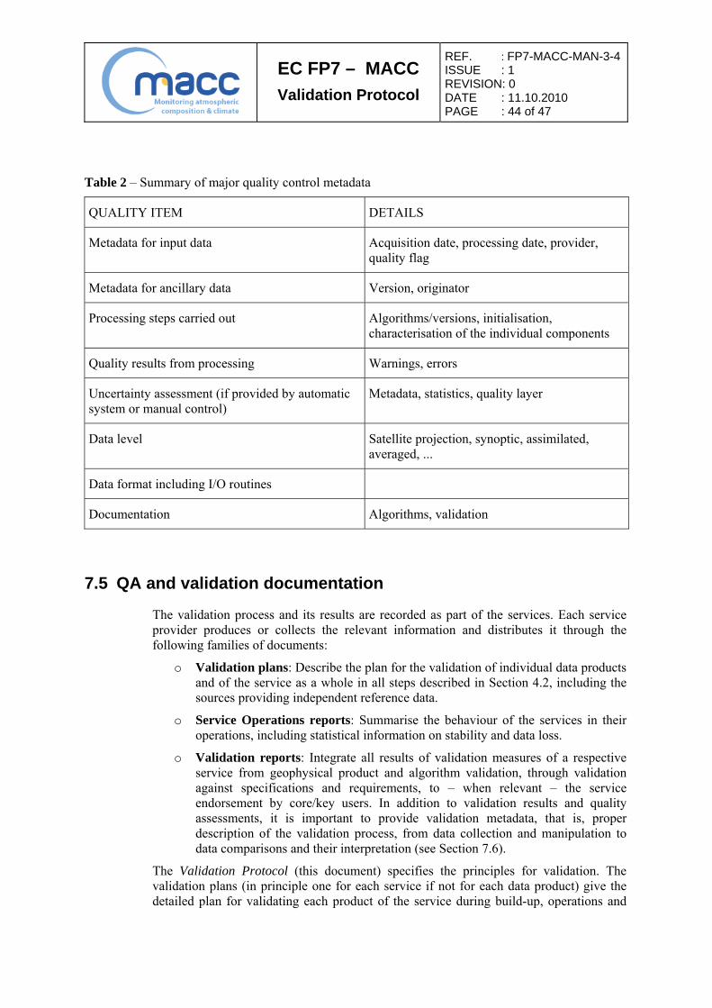
EC FP7 – MACC
Validation Protocol
REF. : FP7-MACC-MAN-3-4ISSUE : 1 REVISION: 0 DATE : 11.10.2010 PAGE : 44 of 47
Table 2 – Summary of major quality control metadata
QUALITY ITEM DETAILS
Metadata for input data Acquisition date, processing date, provider, quality flag
Metadata for ancillary data Version, originator
Processing steps carried out Algorithms/versions, initialisation, characterisation of the individual components
Quality results from processing Warnings, errors
Uncertainty assessment (if provided by automatic system or manual control)
Metadata, statistics, quality layer
Data level Satellite projection, synoptic, assimilated, averaged, ...
Data format including I/O routines
Documentation Algorithms, validation
7.5 QA and validation documentation
The validation process and its results are recorded as part of the services. Each service provider produces or collects the relevant information and distributes it through the following families of documents:
o Validation plans: Describe the plan for the validation of individual data products and of the service as a whole in all steps described in Section 4.2, including the sources providing independent reference data.
o Service Operations reports: Summarise the behaviour of the services in their operations, including statistical information on stability and data loss.
o Validation reports: Integrate all results of validation measures of a respective service from geophysical product and algorithm validation, through validation against specifications and requirements, to – when relevant – the service endorsement by core/key users. In addition to validation results and quality assessments, it is important to provide validation metadata, that is, proper description of the validation process, from data collection and manipulation to data comparisons and their interpretation (see Section 7.6).
The Validation Protocol (this document) specifies the principles for validation. The validation plans (in principle one for each service if not for each data product) give the detailed plan for validating each product of the service during build-up, operations and

EC FP7 – MACC
Validation Protocol
REF. : FP7-MACC-MAN-3-4ISSUE : 1 REVISION: 0 DATE : 11.10.2010 PAGE : 45 of 47
update. The validation reports integrate the results for all products of a service until service endorsement. The service operations report summarises the experiences with the service in operations.
Whereas validation in the build-up phase up to service endorsement is applied one time (with feedback loops if the core user is not satisfied, leading in fine to endorsement of the service by the user), the operations reports are published regularly (to be defined per service in the validation plan).
Validation documentation should be published in the open Portable Document Format (.pdf). It must be archived on the long term and should be made accessible easily and to an audience as wide as possible.
7.6 QA and validation metadata
To facilitate proper interpretation of the validation results, traceability of the validation process is essential. Therefore validation metadata, that is, brief but unambiguous documentation of the entire validation process leading to a validation graph or a comparison data file, should accompany any validation result reported in a validation report and on the project web site. Where validation results are provided in graphical format (e.g. in a .jpeg file), validation metadata can be provided in a legend placed on the graph itself or below; they can also be attached to the graphical file as a readme.file.text. Where validation results are provided in numerical format (e.g. in a ASCII or HDF file), validation metadata can be included in this numerical data file as a header or simply attached externally to the file.
The metadata on the validation process (also called correlative analysis) must provide a short, unambiguous description of the comparison manipulations undertaken to obtain the validation results. From this information one should be able to check if the validation process complies with agreed standards and best practices. The step-by-step description of the data manipulations should also allow proper interpretation of the comparison results and further investigation of the data quality.
Table 3 suggests the minimum information that should be available in the validation metadata to ensure traceability of the validation process. Ideally it should not duplicate information that is already available e.g. in the metadata accompanying the data under evaluation and the validation source.

EC FP7 – MACC
Validation Protocol
REF. : FP7-MACC-MAN-3-4ISSUE : 1 REVISION: 0 DATE : 11.10.2010 PAGE : 46 of 47
Table 3 – Suggested validation metadata
VALIDATION STEP / ITEM DETAILS
High-level description of the content of validation results (graphic file or numerical data file)
Identification of the data being validated and of the reference data used as a validation source, date, basic description of the results being reported
Metadata on data under evaluation Data processing and archiving centre, model/data processor version, input and initialisation data, native data format (e.g. number density or volume mixing ratio, vertical coordinate is altitude or pressure…), data file name (or at least file name convention)
Metadata on reference data used as a validation source
Data processing and archiving centre, instrument, responsible institute, model/data processor version, calibration version (input level-1 data), measured parameter, native data format…
Traceability of validation process Step-by-step description of the data manipulations: data selection, conversion of units, filtering based e.g. on flags or statistical tests, co-location criteria (vertical, horizontal and temporal), re-gridding, smoothing (vertical and horizontal, e.g. using a Gaussian, averaging kernels etc.), range of the comparisons (geographical, vertical, temporal), reference to an agreed reference practice…
Format of validation results Content of the numerical validation data file or description of the information displayed on the validation graph: units, relative or absolute difference, individual comparison pair or monthly mean, amount of comparison events, statistical estimators (mean/deviation or median/interpercentile) …
Credit and responsibilities Analysis carried out at institute X by validation scientist Y supported by data processing scientist Z, contact (email)

EC FP7 – MACC
Validation Protocol
REF. : FP7-MACC-MAN-3-4ISSUE : 1 REVISION: 0 DATE : 11.10.2010 PAGE : 47 of 47
7.7 Compliance with international standards
Interoperability is a driving concept of the GEOSS Implementation Plan in general and GMES developments in particular. Elaborated in this context, the present document gives particular attention to international standardisation requirements formulated e.g. within high-level strategies like the QA4EO framework formalised by the CEOS and the Integrated Global Observation Strategy (IGOS) established by a list of international partners (including CEOS, GAW, GCOS, IGBP, UNEP, UNESCO, WCRP and WMO), and within European initiatives relevant to GMES. Further evolution is anticipated.
7.8 Compliance with INSPIRE
Particular attention must be given to the Directive 2007/2/EC of the European Parliament and of the Council of 14 March 2007, establishing an Infrastructure for Spatial Information in the European Community (INSPIRE) to support Community environmental policies, and policies or activities which may have an impact on the environment. Published in the Official Journal on the 25th of April 2007, the INSPIRE Directive entered into force on the 15th of May 2007. To ensure that the spatial data infrastructures of the Member States are compatible and usable in a Community and transboundary context, the Directive requires that common Implementing Rules (IR) are adopted in a number of specific areas (Metadata, Data Specifications, Network Services, Data and Service Sharing and Monitoring and Reporting). These IRs are adopted as Commission Decisions or Regulations, and are binding in their entirety.
At the time of this issue of the MACC Validation Protocol, IRs have been negotiated and adopted for spatial data themes of Annex I, that is, Coordinate reference systems, Geographical grid systems, Geographical names, Administrative units, and five other themes. IRs for the spatial data themes under Annex II (Elevation, Land cover, Orthoimagery, and Geology) are being established. Data themes under Annex III will have the more direct application to GMES Atmospheric Service. They will be addressed in the timeframe of MACC and the downstream service projects PASODOBLE and EVOSS. They will impact follow-on projects. Among the relevant themes of Annex III: Atmospheric conditions, Environmental monitoring facilities, Statistical units, Human health and safety, Natural risk zones, Meteorological geographic features. Implications of INSPIRE for PROMOTE Stage II and follow-on activities like MACC and PASODOBLE, as well as the contribution of the PROMOTE Validation Office to the development of IRs, are summarised in document D4 Service Network – INSPIRE Technical Note [RD9].
END OF DOCUMENT