
IOH12073 01 R014 Rev 6 - epa.wa.gov.au API main_report_I.pdf · Buckland Project IOH12073_01 R014...
72
Buckland Project Assessment on Proponent Information - Environmental Review
Transcript of IOH12073 01 R014 Rev 6 - epa.wa.gov.au API main_report_I.pdf · Buckland Project IOH12073_01 R014...

Buckland Project
Assessment on Proponent
Information - Environmental
Review
Prepared for Iron Ore Holdings Ltd by Strategen November 2013


Buckland Project
Assessment on Proponent
Information - Environmental
Review
Strategen is a trading name of Strategen Environmental Consultants Pty Ltd Level 2, 322 Hay Street Subiaco WA ACN: 056 190 419 November 2013

Limitations
Scope of services
This report (“the report”) has been prepared in accordance with the scope of services set out in the contract, or as
otherwise agreed, between the Client and Strategen Environmental Consulting Pty Ltd (Strategen). In some
circumstances, a range of factors such as time, budget, access and/or site disturbance constraints may have limited the
scope of services. This report is strictly limited to the matters stated in it and is not to be read as extending, by
implication, to any other matter in connection with the matters addressed in it.
Reliance on data
In preparing the report, Strategen has relied upon data and other information provided by the Client and other
individuals and organisations, most of which are referred to in the report (“the data”). Except as otherwise expressly
stated in the report, Strategen has not verified the accuracy or completeness of the data. To the extent that the
statements, opinions, facts, information, conclusions and/or recommendations in the report (“conclusions”) are based in
whole or part on the data, those conclusions are contingent upon the accuracy and completeness of the data.
Strategen has also not attempted to determine whether any material matter has been omitted from the data. Strategen
will not be liable in relation to incorrect conclusions should any data, information or condition be incorrect or have been
concealed, withheld, misrepresented or otherwise not fully disclosed to Strategen. The making of any assumption does
not imply that Strategen has made any enquiry to verify the correctness of that assumption.
The report is based on conditions encountered and information received at the time of preparation of this report or the
time that site investigations were carried out. Strategen disclaims responsibility for any changes that may have
occurred after this time. This report and any legal issues arising from it are governed by and construed in accordance
with the law of Western Australia as at the date of this report.
Environmental conclusions
Within the limitations imposed by the scope of services, the preparation of this report has been undertaken and
performed in a professional manner, in accordance with generally accepted environmental consulting practices. No
other warranty, whether express or implied, is made.
Client: Iron Ore Holdings Ltd
Report Version Revision No.
Purpose Strategen author/reviewer Submitted to Client
Form Date
Preliminary Draft Report
Rev A Client information
R Chesney, P Brand, J Mitchell, D Panickar
Electronic 25 Mar 2013
Rev B Drafting of figures
Electronic 17 Apr 2013
Rev C Client review D Panickar, L Taylor, H Ventriss, J Mitchell / H Ventriss
Electronic 19 Apr 2013
Rev 0 For preliminary OEPA review (not submitted)
L Taylor, J Mitchell / H Ventriss Electronic 29 May 2013
Rev 1 For preliminary OEPA review
L Taylor, J Mitchell / H Ventriss Electronic 30 May 2013
Final Draft Report Rev D Client review A Welker, T Stehbens, L Taylor, J Mitchell / H Ventriss
Electronic 2 Jul 2013
Final Report Rev 2 For EPA review T Stehbens, J Mitchell / H Ventriss
Electronic & hard copy
5 Jul 2013
Final Draft Report Rev E Client review H Ventriss Electronic 10 Oct 2013
Final Report Rev 3 For EPA review H Ventriss Electronic & hard copy
16 Oct 2013
Draft Report Rev F Client review H Ventriss Hard copy 19 Nov 2013
Final Report Rev 4 For EPA review H Ventriss Electronic & hard copy
19 Nov 2013
Final Report Rev 5 For EPA review H Ventriss Electronic & hard copy
21 Nov 2013
Final Report Rev 6 Issued for use H Ventriss Electronic & hard copy
27 Nov 2013
Filename: IOH12073_01 R014 Rev 6.docx - 27 November 2013

Buckland Project
IOH12073_01 R014 Rev 6.docx
27-Nov-13
Table of contents
1. Introduction 1
1.1 EPA Process 1
1.2 Australian Government environmental impact assessment process 1
2. Proposal 2
2.1 Proponent details 2
2.2 Key proposal characteristics 2
2.3 Proposal location 2
2.3.1 Proposal tenure 3
2.3.2 Landscape and social context 3
2.4 Proposal overview 3
2.4.1 Project elements 3
2.4.2 Timeframe 4
2.4.3 Design status 4
2.4.4 Design philosophy 4
2.5 Detailed description 4
2.5.1 Mine pits 4
2.5.2 Flood protection bunds 5
2.5.3 Processing facilities 5
2.5.4 Project services and infrastructure 6
2.5.5 Waste (sub-grade) materials 8
2.5.6 Mine pit dewatering 12
2.5.7 Stormwater management 12
2.5.8 Disposal of surplus water 13
2.5.9 Mine site rehabilitation and closure 15
2.5.10 Haul road alignment and construction 15
2.6 Alternatives considered 16
3. Stakeholder consultation 17
4. Environmental impacts and management 20
4.1 Approach 20
4.2 Environmental impact assessment tables 20
4.3 Environmental impact assessment 37
4.3.1 Environmental Factor: Hydrological processes 37
4.3.2 Environmental Factor: Inland Waters Environmental Quality 39
4.3.3 Environmental Factor: Flora and vegetation 42
4.3.4 Environmental Factor: Terrestrial fauna 44
4.3.5 Environmental Factor: Subterranean fauna 47
4.4 Consolidated management commitments 49
5. Other potential impacts and activities 53
6. Cumulative impacts 57
7. Offsets 59
8. References 60
9. Figures 65
List of tables
Table 1 Summary of the Proposal 2
Table 2 Key Proposal characteristics 2
Table 3 Sulfur distribution in below water table waste rock samples, Bungaroo Creek deposits 9
Table 4 Quantified WRD annual water balance (Aquaterra 2013d) 9
Table 5 Estimated design flows for various ARI events 10
Table 6 Order of magnitude water balance for both WFSF ponds – average year, outflows only 10
Table 7 Stormwater control zones 12
Table 8 Consultation summary 17

Buckland Project
IOH12073_01 R014 Rev 6.docx
27-Nov-13
Table 9 Planned and completed studies for the Buckland Project 22
Table 10 Supporting studies timeline 25
Table 11 Compliance of studies with EPA Guidance and Position Statements 26
Table 12 Summary of key findings 27
Table 13 Environmental Factor: Hydrological processes 37
Table 14 Environmental Factor: Inland Waters Environmental Quality 39
Table 15 Environmental Factor: Flora and vegetation 42
Table 16 Environmental Factor: Terrestrial fauna 44
Table 17 Environmental Factor: Subterranean fauna 47
Table 18 Consolidated management commitments 49
Table 19 Other environmental impacts and activities – other legislation and approvals 53
Table 20 Cumulative impact assessment 57
List of figures
Figure 1 Regional location
Figure 2 Conceptual project layout: mine and support infrastructure area
Figure 3 Conceptual project layout: haul road
Figure 4 Conceptual mine development sequence (Bungaroo South west and east pits)
Figure 5 Typical flood bund cross-sections (from RPS 2012a)
Figure 6 Ore crushing and wet processing flow-chart
Figure 7 Location and layout of the proposed waste fines storage facility
Figure 8 ANCOLD terminology (top) and WFSF embankment design detail
Figure 9 Bungaroo South western pit cross section and sulfur distribution
Figure 10 Bungaroo South eastern pit cross section and sulfur distribution
Figure 11 Predicted groundwater reinjection schedule
Figure 12 Potential creeklines (blue) for contingency dewater disposal (from RPS 2013c)
Figure 13 Haul road river crossing floodway conceptual design
Figure 14 Groundwater drawdown and dewatering discharge after one year of operation
Figure 15 Impacts of groundwater drawdown and dewatering discharge at end of mining
Figure 16 Groundwater recovery rates following mine closure
Figure 17 Groundwater levels 5 years after closure
Figure 18 Groundwater levels 80 years after closure
Figure 19 Estimated change in Bungaroo Creek flood heights as a result of bund incursions and channel
deepening; Creek 4 flows past the western pit and Creek 3 the eastern pit (RPS 2012a)
Figure 20 Haul road Robe River crossing: 2-year ARI flood event afflux
Figure 21 Particle flow paths and associated travel distances at closure
Figure 22 Particle flow paths and associated travel distances 80 years after closure
Figure 23 Local scale vegetation mapping within the mine area
Figure 24 Regional vegetation associations within the Proposal area
Figure 25 TEC and PEC locations
Figure 26 Priority flora recorded within the mine area
Figure 27 Conservation significant fauna recorded in the mine area
Figure 28 Conservation significant fauna recorded in the Stage 1 haul road survey area – Bungaroo South
to API rail head
Figure 29 Conservation significant fauna recorded in the Stage 1 haul road survey area – API rail head to
North West Coastal Highway, and the Stage 2 haul road survey area
Figure 30 Fauna habitat mapping in the mine area
Figure 31 Northern Quoll habitat mapping
Figure 32 Fauna habitat mapping in the Stage 1 haul road survey area – Bungaroo South to API rail head
Figure 33 Fauna habitat mapping in the Stage 1 haul road survey area – API rail head to North West
Coastal Highway, and the Stage 2 haul road survey area
Figure 34 Troglofauna sampling locations
Figure 35 Stygofauna sampling locations

Buckland Project
IOH12073_01 R014 Rev 6.docx
27-Nov-13
List of appendices
Appendices can be found on the CD-ROM enclosed within the cover of this document.
Appendix 1 Supporting assessment tables
Appendix 2 Supporting documents
Appendix 3 Checklist for documents submitted to EPA on terrestrial biodiversity
Appendix 4 Environmental Offsets Reporting Form
Appendix 5 Spatial data
Appendix 6 Northern Quoll Management Plan


Buckland Project
IOH12073_01 R014 Rev 6.docx
27-Nov-13 1
1. Introduction
Iron Ore Holdings Limited (IOH, the Proponent) proposes to develop the ‘Buckland Project’ (the Proposal),
an iron ore mining project in the western Pilbara (Figure 1). The Proposal involves mining iron ore from
three deposits; initially from above the watertable and then proceeding to below the watertable for two of
the three deposits, processing the ore on site and transporting the iron ore product by road to the customer
delivery point at Cape Preston.
1.1 EPA Process
Following referral of the Proposal, the Environmental Protection Authority (EPA) determined that it should
be assessed at the Assessment on Proponent Information Level of assessment. A scoping guideline for
the environmental impact assessment was issued by the EPA on 12 February 2013. This Environmental
Review (ER) document has been prepared to address the EPA requirements as set out in the scoping
guideline and responses from government agencies to the version of the ER document submitted for
review on 11 July 2013.
1.2 Australian Government environmental impact assessment process
The Environment Protection and Biodiversity Conservation Act 1999 (EPBC Act) requires a Proposed
Action likely to have a significant effect on a matter of National Environmental Significance (MNES) to be
referred to the Department of the Environment (DotE), formerly the Department of Sustainability,
Environment, Water, Population and Communities (DSEWPaC), for assessment.
IOH referred the Proposal to DotE on 17 May 2013 (2013/6867), with the agency subsequently
considering that the Proposal did not need approval under the EPBC Act, provided the Proposal was
implemented in a particular manner.

Buckland Project
IOH12073_01 R014 Rev 6.docx
27-Nov-13 2
2. Proposal
2.1 Proponent details
The Proponent is Iron Ore Holdings Limited (ABN: 17 107 492 517). The key proponent contact details for
the Proposal are:
General Manager Corporate Affairs
Iron Ore Holdings Limited
Level 1, 1 Altona Street
West Perth, WA, 6005
Phone: 08 9483 2000
Email: [email protected]
2.2 Key proposal characteristics
The key characteristics of the Proposal are presented below as per the relevant EPA (2012) guidance:
• Table 1 summarises the Proposal
• Table 2 details the key characteristics of the Proposal.
Table 1 Summary of the Proposal
Item Description
Proposal title Buckland Project
Proponent name Iron Ore Holdings Limited
Short description The Proposal is to construct and operate an iron ore mine located approximately 45 km south-southeast of Pannawonica, with the ore transported by purpose-built and public roads to a customer delivery point near Cape Preston.
Table 2 Key Proposal characteristics
Element Location Proposed extent authorised
Physical elements:
Mine and infrastructure area Figure 2 Development of not more than 650 ha within a development envelope of 1600 ha.
Haul road Figure 3 Development of not more than 1400 ha within a development envelope of 7200 ha.
Operational elements:
Dewatering Figure 2 Groundwater abstraction not more than 4.75 GL/a.
Disposal of excess dewater to aquifers
Figure 2 Sub-surface re-injection/reticulation of recovered groundwater from dewatering system, of up to 4.5 GL/a.
Disposal of excess dewater and other waters as surface discharge
Figure 2 Surface discharge of excess water (stormwater runoff; dewater if reinjection system is non-operational) into local drainage lines.
Backfilling of mine pits Figure 4 Progressive backfilling of below water table mine voids so that the final surface levels are at a higher elevation than the pre-mining groundwater levels to prevent the formation of permanent pit lakes.
2.3 Proposal location
The Proposal is located in the western Pilbara region of Western Australia (Figure 1) and involves mining,
processing and delivery of iron ore to a customer delivery point. The mining and processing area is
located approximately 45 km south-southeast of Pannawonica and is within the Bungaroo Creek Water
Reserve (see section 2.3.2). The mined ore would be hauled approximately 170 km along a purpose-built
haul road to the customer delivery point at Cape Preston East.

Buckland Project
IOH12073_01 R014 Rev 6.docx
27-Nov-13 3
2.3.1 Proposal tenure
The proposed mine pits are located on tenement M 47/1464. The Stage 1 preferred haul road will be
located on tenements E 47/1279, E 47/1280, E 08/1294, E 08/1289, E 08/1686, AML 70/0248, E 08/1293,
L 08/0076 and E 08/1826. An alternate Stage 1 haul road would be located on tenements E 08/1686,
E 08/1196, M 08/0397, E 08/1453, E 08/1439, E 08/2137, E 08/1772 and E 08/1148. The Stage 2
preferred haul road will be located on tenements E 08/1624, E 08/0117, E 08/1451, E 08/1331, E 08/1585,
E 08/2089, L 08/0074, E 47/2653, G 08/0063 and G 08/0074. The Stage 2 alternate haul road would be
located on tenements E 08/0117, E 08/1451 and E 08/1585.
The Proponent has submitted Miscellaneous Licence applications to Department of Mines and Petroleum
(DMP) for Stage 1 of the haul road, and anticipates that the licences will be finalised by end of 2013.
Miscellaneous licence applications for Stage 2 of the haul road have been submitted and access
agreements are being negotiated. IOH is currently negotiating an access agreement with Rio Tinto Iron
Ore for the reinjection borefield and anticipates this will be finalised in late 2013.
2.3.2 Landscape and social context
Land use in the Pilbara region consists predominately of mining, conservation, Unallocated Crown Land,
Crown reserves, urban areas and pastoral activities. Several pastoral leases in the region are held by
mining companies as a means of securing access to land surrounding their operations. The mine part of
the Proposal sits within Unallocated Crown Land.
A significant proportion of land in the Hamersley sub-region is reserved (14.1%), which includes the
majority of the Karijini National Park (Onshore 2012). The proposed mine is located within the boundaries
of the proposed West Hamersley Range Conservation Park (Figure 1). The proposed conservation park
was initially recommended in 2002 to ensure species and floristic communities recorded from summit
(upland) habitats in the Hamersley Ranges are protected within the conservation estate (CALM 2002).
The recommendation to create the conservation park acknowledges the mineral prospects and existing
Mining Act 1978 tenure in the area. Consultation with the Department of Parks and Wildlife (DPaW)
indicates the prospective conservation park will be managed within a multiple-use framework that does not
exclude mining activities.
The Proposal is located within the proposed Bungaroo Creek Water Reserve (Figure 1), which is a future
groundwater source for the supply of drinking water into the West Pilbara Water Supply Scheme. The
Department of Water (DoW) proposes to establish the Bungaroo Creek Water Reserve as a Public
Drinking Water Supply Area (PDWSA) under the Country Areas Water Supply Act 1947 to protect the
water source for the Bungaroo Coastal Water Supply Borefield (BCWSB) and the Bungaroo and
Jimmawurrada Creek catchment areas that recharge the aquifer. DoW has recommended that the water
reserve be managed for Priority 1 source protection, with 500 m wellhead protection zones established
around all production bores, to help protect the source of water used for abstraction and potable supply.
DoW defines Priority 1 areas as water sources requiring management to ensure there is no degradation of
the quality of the drinking water source using the principle of risk avoidance.
2.4 Proposal overview
2.4.1 Project elements
The Proposal consists of two major elements:
1. The proposed mine area (pits and associated flood-protection bunding, ore processing facilities,
dewatering and disposal systems, waste rock dumps, waste fines storage facilities, accommodation
village and supporting infrastructure) (Figure 2). At the end of mining (15–20 yrs), waste rock dumps
and waste fines storage facilities will have been removed and used to backfill the below water table
mining voids, to prevent the formation of permanent pit lakes. All disturbed areas will be
rehabilitated.
2. The proposed haul road to transport product to the customer delivery point at Cape Preston East
(Figure 3) will be constructed in two stages:

Buckland Project
IOH12073_01 R014 Rev 6.docx
27-Nov-13 4
• Stage 1 haul road (approximately 100 km) links the mine area to the North West Coastal
Highway. Ore will be transported along Stage 1 and the North West Coastal Highway under
approval from Main Roads WA (MRWA) for its first years of production, up to 8 Mtpa.
• Stage 2 haul road links Stage 1 directly to the customer delivery point to service the operations at
its long-term production rate of 8 Mtpa, bypassing North West Coastal Highway.
The Proposal does not include any activities beyond the customer delivery point.
2.4.2 Timeframe
Project construction is anticipated to commence in 2014 with the first truckload of ore occurring in 2016,
depending on receipt of all necessary approvals and funding arrangements. Within six months of
production commencing, IOH expects to have reached the nominal initial production rate of 4 million
tonnes per annum (Mtpa) and will then progressively increase to an estimated long-term production rate of
8 Mtpa. The Proposal is expected to have an operational life of approximately 15–20 years.
2.4.3 Design status
IOH has recently completed preliminary feasibility studies for the many aspects of the Buckland Project
and is currently progressing though a detailed design phase. The Proposal description provided here is
based on design principles and minimum criteria developed during the preliminary feasibility process.
The level of project detail will increase significantly as the project design phase continues into the
bankability stage, particularly as IOH applies for specific secondary permits and licences, and must be able
to satisfy the information requirements specific to the scope of the particular approval. The Proposal
description aims to be of adequate scope so that those information requirements are identified and framed
within this ER document.
2.4.4 Design philosophy
The placement, layout and design of the key components of the Proposal reflect the due consideration that
IOH has given to industry standards, stakeholder inputs and to government and industry sustainability
guidelines. The design of the Buckland Project has sought to achieve a good balance between the optimal
recovery of the economic mineral resources and the environmental and cultural values of the project site.
Of particular importance is the location of the mining and processing element within a Priority 1 (P1) Public
Drinking Water Supply Area (Country Areas Water Supply Act 1947 Water Reserve). The IOH project
design team has ensured the Proposal is consistent with the WA government principle of risk avoidance
for P1 water reserves (DoW 2012) by incorporating the requirements and recommendations of all relevant
policies, plans and guidelines into the project scope. The outcomes of this process are demonstrated in
Appendix 1.
2.5 Detailed description
2.5.1 Mine pits
Four pits are proposed in three pisolitic channel iron deposits (CIDs), located within approximately seven
kilometres of each other (Figure 2):
• Bungaroo South (western): mining above and below watertable
• Bungaroo South (eastern): mining above and below watertable, in two pits
• Dragon: mining above watertable only.

Buckland Project
IOH12073_01 R014 Rev 6.docx
27-Nov-13 5
Preliminary mine plans start at the Bungaroo South western pit and then progress to the eastern pits.
Mining of the Dragon deposit is scheduled for later in the mine life, but may be brought forward as a
contingency if the Bungaroo South pits become inaccessible due to flooding (see below). Initial mining in
the western pit will only extract ore from above the water table. Mining below the water table is expected
to commence in year 3. To prevent the mine voids from affecting groundwater resources after closure, the
three pits will be backfilled to above the level of the pre-mining water table.
Ore will be mined using conventional drill and blast techniques and hauled by truck to the crushing and
processing plant. Overburden and waste rock will be trucked to proposed temporary waste rock dump
(WRD) areas or used to directly backfill the Bungaroo South pits.
2.5.2 Flood protection bunds
The two Bungaroo South deposits extend into the Bungaroo Creek system and the active pits will be
encompassed by bunds for protection from periodic floodwaters. Parts of the ore reserve have been
sacrificed from the mine plan to minimise potential impacts to the hydrological, ecological and cultural
functions of the creeklines (Figure 2). A minimum 50 m channel width has been incorporated into the mine
design in this regard. The proposed mining solution has been selected from a number of options,
including complete diversion of the creek (see section on alternatives considered).
The 100-year Annual Recurrence Interval (ARI) flow event peak, with at least 1 m freeboard, has been
adopted for the bund design. Larger creek flows are expected to overtop the bund and flow into the pit via
constructed spillways. The design criteria for the bunds have been developed based on catchment
modelling (RPS Aquaterra 2012a).
IOH has yet to finalise detailed geotechnical and design studies for the bunds, which would be required to
obtain approvals from the DMP prior to the commencement of mine development. Information arising from
the preliminary design studies (Figure 5) indicates the following:
1. The total bund length is approximately 7.5 km and bund height will be typically 3 to 6 m including
freeboard. The crest width will typically be 30 m to accommodate a haul road. Emergency spillways
will be incorporated into the design so that overtopping can be managed.
2. The flood bunds will be constructed of the most suitable material available, typically non-mineralised
mine waste, which is understood from the current schedule to primarily comprise alluvium (shingle).
On the creek side of the bund, rock armouring (rip-rap, gabions and/or geotextile) will be placed to
prevent erosion and undermining.
3. The main creek channel will continue to accommodate most flows, but will need to be deepened
and/or relocated within the shingle flood-plain along certain reaches.
4. Foundation preparation will form an integral part of the final design and construction processes for
the bunds.
5. The bund for the western pit will be built in the first year of development, while the bund for the
eastern pit will not be constructed until approximately year 5. Experience gained from the western pit
flood bund will be used in the subsequent flood bund design and construction for the eastern pits.
As part of mine closure, the bunds will be re-contoured to form a more stable and enduring structure to
continue to divert the majority of creek flows around the back-filled pits, which will still initially have a
surface level about 10 m below the surrounding floodplain but are expected to fill over time (see section on
mine closure).
2.5.3 Processing facilities
For at least the first two and a half years, ore will be mined from above the water table and processed
through a dry crushing and screening plant to produce a single 12 mm product (direct shipping ore). In
terms of deliverable product, the moisture content of ore mined from above the watertable will be
approximately 9%. To progress to mining ore below the watertable, the dry processing plant will be
expanded to include additional crushing, washing and wet-screening processes to remove clay fines
(material less than 1 mm in diameter) from the crushed ore (Figure 6).

Buckland Project
IOH12073_01 R014 Rev 6.docx
27-Nov-13 6
After the washing and wet-screening stages, the process wash water is fed to a waste fines thickener,
where flocculants and/or coagulants are added to settle out waste fines. Treated wash water is returned to
the process water circuit, via the process water pond. The thickened waste fines (50% solids by weight)
are pumped to the waste fines storage facility (WFSF). Following deposition of the fines slurry into the
WFSF, the water component is decanted and returned to the process water pond. All water streams
(process, treated and return) will be routinely monitored for water quality parameters, such as pH and
suspended solids content. Additional treatment options, such as pH-correction, would be incorporated into
the process water circuit if required.
The combined plant location (Figure 2) has been set back more than 100 m from major creeklines to
reduce interference with the banks and as a buffer for managing area runoff.
2.5.4 Project services and infrastructure
Mine infrastructure will include power, water, fuel and maintenance facilities, plus accommodation for the
construction and operations workforce and operations personnel. At this stage of planning, support
facilities, including on-site accommodation, workshops, warehousing and power generation, are proposed
to be located in proximity to the processing plant to minimise power distribution and interconnecting road
construction costs.
The Buckland Project centralised infrastructure will include:
• administration centre
• gate house and emergency response centre
• mine camp
• central power house and distributed supply
• warehousing and lay down areas
• maintenance facilities for mine and light vehicles
• maintenance facilities for haul trucks (most of the fleet maintenance will be conducted at the Cape
Preston East receival point)
• laboratory and core farm
• fuel storage and distribution
• integrated communications.
The following infrastructure will be situated at other locations convenient to the mining operations:
• explosive storage
• dewatering and reinjection borefields
• landfill (located outside of the P1 Water Reserve in the Bungaroo Creek catchment).
Administration
Administration and associated amenities will likely comprise prefabricated modular buildings with power,
communications and IT services connected as appropriate, as well as water and sewerage services. An
ablution block will be located within this area.
Power generation and transmission
Power generation is required to support construction, ore processing and associated mining operation
support infrastructure. Power will be generated via on-site diesel generator engines located within the
Proposal development area. The total maximum power requirement and output will not exceed 8 MW.
Gas powered electricity generation has been discounted due to the small size of the power station relative
to other regional power stations, and the high cost to deliver a continuous supply of gas to the minesite.
A combination of overhead and underground power reticulation will distribute power to workshops, camp
and administration facilities, water supply and wastewater treatment.

Buckland Project
IOH12073_01 R014 Rev 6.docx
27-Nov-13 7
Workforce and accommodation
A 100-person temporary camp will be built for initial construction, based on standard temporary ‘early
works facilities’ and this will then be gradually expanded into a 322 room permanent facility with around
215 personnel on site at any one time.
IOH will provide a level of preference to the employment of local Aboriginal community members and
contracting businesses by developing an understanding of the Kuruma Marthudunera claim group’s
capabilities and actively matching them to positions vacant. This process has been agreed with by the
Kuruma Marthudunera people and included in the Native Title agreement finalised in October 2012.
Employees sourced from elsewhere will be managed on a fly in-fly out basis. Personnel will fly to Karratha
and then be transported via a bus service to the Proposal area. Potential airstrip locations suitable for jets
in the Proposal area are extremely limited and not located on IOH lease areas and at this stage have been
discounted as viable options.
Water supply and sewage treatment
Total water supply requirements (construction and operation) are expected to be up to 1.36 GL/a for
processing, dust suppression and potable water supply.
Raw water for the Bungaroo site will be sourced from dewatering bores. Water will be pumped to central
storage tank for process and general use. Distribution will be via pumps and a steel and high density
polyethylene pipe network.
Water will be used for dust suppression during road construction and total water demand will be
approximately 3 ML/d for the duration of the construction phase depending on the nature of the
construction activities occurring in proximity to each borefield at the time. Water required for construction
of the first stage of the transport road is expected to be supplied from the minesite borefield. Groundwater
will be obtained from bores to be constructed approximately every 10 km along the second stage of the
transport road to supply water for dust suppression activities during construction of this second stage of
the road. Water from these bores will be abstracted sequentially as construction areas move progressively
along the road alignment.
Potable water will be treated with appropriate filtration and chemical conditioning to comply with the
Australian Drinking Water Guidelines (NHMRC & NRMMC 2011) for camp use and distributed to the
workshops, administration centre and processing plant. The use of standalone potable water tanks will be
minimised to decrease the associated health and safety issues.
Fire and general purpose water will be reticulated in a common system. Detailed design will optimise
piping, pumping and intermediate storage requirements.
Integrated ablution facilities will be linked to ‘Biomax’ type plants at major facilities for waste treatment.
Other toilets, if required, will use a gravity fed septic system. Processed effluent will be disposed of
through subsoil irrigation in a suitable area adjacent to the site (the final locations are to be determined
based on geotechnical and environmental assessment).
Warehousing and maintenance workshops
Storage will be provided using an 500 m2 (approx.) shed for bulky items and sea containers for the
remainder. An open-air laydown area will be provided adjacent to the secure store for large non-
perishable items. Maintenance workshops will generally be made up from sea containers with domed
covers.
A vehicle wash down facility will be located at the mine vehicle maintenance workshop and will provide for
both heavy and light vehicles. The facility will be a conventional arrangement based on water cannons on
a drainage slab with a drive–in collection sump and oily water separator, designed to meet DoW guidelines
as a minimum (see Appendix 1). Used water will be recycled for dust control on roads and sludge will be
periodically removed.

Buckland Project
IOH12073_01 R014 Rev 6.docx
27-Nov-13 8
Laboratory and core shed
An area will be required for exploration, grade control and product specification analysis. The facility will
have core cutting, crushing and screening equipment (in an undercover area) and an enclosed building to
provide an office and house laboratory equipment. Sea containers and laydown areas will be used for
sample storage.
Fuel supply and storage
Diesel fuel will be delivered by triple road train to a centralised fuel farm consisting of five, 110 kL self
bunded tanks, providing two weeks operating capacity for the mine. The haulage fleet will be
predominantly refuelled out of Cape Preston East.
Refuse disposal/treatment
Putrescible wastes from the mine and camp will be transported offsite and disposed in a licensed landfill
facility outside of the P1 Water Reserve. Inert material will be disposed of on-site in an approved area.
Separate areas will be maintained to temporarily store and consolidate recyclables, tyres, hydrocarbons
and hazardous waste prior to removal to appropriately-licensed recycling or secure disposal facilities.
Telecommunications
A communications tower will be located centrally within the broader disturbance footprint to provide mobile
phone and UHF radio coverage for all mine and exploration areas.
2.5.5 Waste (sub-grade) materials
Initial mine overburden, including alluvium and hardcap, will be used in the construction of roads, pads,
ramps and bunds. This material will be sourced entirely from above the water table and will not present a
risk to catchment water quality.
Waste rock
For the Bungaroo South western pit and Dragon deposit, remnant overburden and non-mineralised (i.e.
waste) rock from within the orebody will be trucked from the mine pits to designated waste rock dumps
(WRD). For the eastern pits, waste rock will be backfilled directly into the western pit. An additional area
has been designated for the storage of low-grade ore (Figure 2), which will be reserved for processing and
blending as opportunities arise. The proposed WRD will be constructed on upland areas mapped as
indurated (weathered) Brockman Iron Formation material of the Dales Gorge Member (Williams 1968),
with the depth to groundwater recorded as 55 to 60 m below ground level (Aquaterra 2012b).
While detailed designs for the WRD are yet to be completed, preliminary design studies have identified the
following characteristics:
• based on a strip ratio of 0.8, approximately 100 million tonnes of waste rock will be generated
• dump heights will be about 90 m and will have an overall batter angle of less than 20°, as per
DMP guidelines (DoIR 1999)
• total footprint will be approximately 250 ha
• the dumps will be constructed as small lifts to manage the broad range of particle sizes in the
waste materials.
The waste rock will consist of different material types, namely:
• 40–50% Quaternary alluvium: consisting of pebble-gravel-sand mixtures with little fines
• 30–40% internal sandy clays and silts
• up to 10% low grade CID material: generally partially to well cemented gravelly sands in a silty
matrix

Buckland Project
IOH12073_01 R014 Rev 6.docx
27-Nov-13 9
• 10–20% extremely to highly weathered BIF and shales.
The geochemistry and potential to generate acidic and metalliferous drainage (AMD) of these waste rock
materials has been analysed (URS 2013). The results indicate that the materials are predominantly
barren, with a median total sulfur content of 0.01% by weight (dry) and have a low overall acid neutralising
capacity (0 to 7 kg H2SO4(eq)/tonne, based on the conservative assumption that all sulfur in the samples is
present as pyrite). This result is consistent with the IOH geological records (Buckland 2012 drill database,
summarised in Table 3), which for waste rock materials (either non-mineralised strata or Fe content less
than 50%), also returned a median total sulfur content of 0.01%. Of the 2262 waste rock samples in the
database, only nine samples (0.4%) had total sulfur values over 0.1%. Although this assessment is both
preliminary and conservative, the indications are that the AMD risk is low (see Table 12 and URS 2013).
Nevertheless, the design of the above-ground WRD will incorporate AMD risk reduction measures, such
as:
• maintain 50 m minimum separation distances between dumps and the edge of the Bungaroo
Creek
• the basement, toes and batters of the WRD will be constructed of non-acid forming (NAF)
material; batters will be also be erosion-resistant
• cut-off drains will be constructed to prevent runoff from undisturbed areas from entering the WRD
area and to ensure any flows from the WRD are isolated and monitored.
These measures will be supported by programs to further characterise and delineate different waste rock
materials, including kinetic testing of waste rock samples to verify the AMD risk (see Section 4.3.2), noting
that after 2021, the WRDs will be returned to the mine pits as backfill.
Table 3 Sulfur distribution in below water table waste rock samples, Bungaroo Creek deposits
No. Samples Median Total S 90%-ile 99%-ile No. greater than 0.1%S
2,622 0.010% 0.017%S 0.045%S 9 (0.4%)
The potential for infiltration into the WRD from rainfall has been reviewed (RPS Aquaterra 2013d, Table 4),
with an estimated 90% of rainfall being shed as runoff or lost as evaporation. The remainder would be
stored internally or lost as seepage along the basement of the WRD (15 ML/yr) or infiltration to the soil
profile (35 ML/yr). Seepage will be collected by the cut-off drains, while any infiltration to groundwater over
the life of the project would be captured by the dewatering network.
Table 4 Quantified WRD annual water balance (Aquaterra 2013d)
INFLOW OUTFLOW Retention within WRD Rainfall Runoff & evaporation Infiltration to groundwater Leakage from Toe
704 816 m3 634 334 m
3 35 241 m
3 15 000 m
3 20 214 m
3
Waste fines storage facility (WFSF)
For the first five to six years of wet processing at the mine, waste fines from the process water treatment
plant will be stored in a waste fines storage facility (WFSF), which will consist of two dams constructed on
prepared areas to the north of the Bungaroo South pits (Figure 7). A two-pond system will facilitate
improved consolidation and drying of the waste fines, and will minimise overall embankment heights.
The civil and structural design of the two dams will comply with, as a minimum, the Mines Safety and
Inspection Act 1994, the DMP (draft) Code of Practice for Tailings Storage Facilities in WA (DMP 2013),
the WA Government Water Quality Protection Guidelines and relevant ANCOLD guidelines and Australian
Standards.
Once mining in the western pit is completed, waste fines from the processing plant will then be disposed in
combination with waste rock to the pit as backfill. The WFSF will then also be used as backfill for the
Bungaroo South pits, once its contents have dried sufficiently to enable rehandling.

Buckland Project
IOH12073_01 R014 Rev 6.docx
27-Nov-13 10
The combined capacity of the two dams will be sufficient to accommodate five years generation of fines
with an additional one-year volume as a contingency, as well as freeboard and additional allowances for
flood protection and earthquake hazard (Figure 8). For the purposes of flood protection in a P1 Water
Reserve, the design storage allowance will be sufficient to accommodate (i.e. without overtopping) the
larger of the following two probabilities:
• the 100-year ARI wet season runoff (no evaporation, runoff coefficient being 1 and 70% of annual
rainfall), which equates to 253 mm
• the 100-year ARI, 72-hour cyclone event, which equates to 5.26 mm/hour over 72 hours or
379 mm.
Initial calculations (Table 5) are that the design flood storage (100-year ARI cyclone event) would exceed
the required storage for a 1000-year ARI (Significant) or Probable Maximum Flood (PMF) event under
peak inflow and total runoff conditions. However, the impoundments may still spill if the PMF event is
exceeded and, as per ANCOLD guidelines for tailings dams (ANCOLD 2012), an emergency spillway will
be included in each embankment design. The height between the base of the spillway and the crest of the
dam wall will be a minimum of 1 m (as a safeguard to accommodate settling or slumping for seismic
events), with a minimum 1 m freeboard above the maximum operating level of the pond.
Table 5 Estimated design flows for various ARI events
ARI
Design Flood, Pond 1 Design Flood, Pond 2
Peak inflow (m
3/s)
Inflow volume (m
3)
Peak inflow (m
3/s)
Inflow volume (m
3)
100-year 21.1 9,260 33.6 14,800
100-yr cyclone 0.59 152,698 0.94 243,025
1000-year 44.5 9,950 71 15,900
PMF 156.9 88,100 250.2 140,000
Inflows to the ponds from the surrounding catchments will be minimised by constructing cut-off berms
across valleys in the northern sections (Figure 7), which will also function as haul roads for waste rock. As
a precautionary measure, the design storage of the ponds will be based on the total catchment area. All
pipes to and from the WFSF that are not within controlled and supervised areas will be fitted with
automatic cut-off systems to safeguard against loss of material to the environment in the event of pipe
failure.
The decant system to collect and return supernatant to the process water circuit for re-use has been
designed to accommodate the rate of return flows, including the majority of rainfall. This will minimise
residence time and limit opportunity for downward infiltration or seepage through the dam walls. Any
infiltration, which is expected to be minimal (Table 6), will be captured at the base of each valley in
interception trenches or, as groundwater, will flow towards the site dewatering bores. Seepage through
the wall will be collected in toe drains and will, along with any leachate recovered in the interception
trenches, be monitored (volume and chemistry) and pumped to the decant system for return to the process
water circuit. The option of installing basin interception drainage systems within the WFSF was considered
but determined to be too prone to blockage given the nature of the fines materials, as well as potentially
reducing the structural integrity of the embankments. However, the final design remains subject to the
approval of the DMP (DMP 2013).
Table 6 Order of magnitude water balance for both WFSF ponds – average year, outflows only
Outflows, Pond 1 (ML/yr) Outflows, Pond 2 (ML/yr)
Decant-peak Decant-average Infiltration Decant-peak Decant-average Infiltration
520 150 70 620 140 80

Buckland Project
IOH12073_01 R014 Rev 6.docx
27-Nov-13 11
The geochemistry of the waste fines has been assessed (URS 2013), based on a limited number (six1) of
fines samples from pilot studies conducted as part of the project feasibility studies. Where suitable and
sufficient material was available, the following tests were conducted:
• pH, EC, major ions, acid-base accounting (ABA), exchangeable ions and multi-element analysis
(XRF) on dried waste fines
• pH, EC, major ions, alkalinity and multi-element analysis on supernatant liquid supplied with the
fines sample and, where collected, leachate from the fines samples.
All six waste fines samples were classed as NAF-Uncertain-Barren (URS 2013). All supernatant samples
and all leachate samples satisfied either the water quality criteria specified in the Australian Drinking Water
Guidelines (NHMRC & NRMMC 2011) or were below naturally occurring levels in Bungaroo South
groundwater, or both.
The process of re-mining the waste fines and the embankments for backfilling the Bungaroo South mining
voids will be carefully managed to ensure that the risk of stormwater flushing fines and other debris from
the valleys and into Bungaroo Creek is thoroughly minimised. Safeguards and contingencies will include:
• conducting works during the dry season (negligible risk of rainfall)
• staging works to specific areas
• maintaining interception and monitoring facilities
• construction of additional interception and sedimentation facilities along flow lines.
Where appropriate, sedimentation basins may remain after closure to protect the catchment until
stabilisation and revegetation of the site is complete. These aspects of site closure will be described in
detail in the Mine Closure Plan (see Section 4.3.2).
Basement rock
The drilling and materials testing programs for the Buckland Project have confirmed the presence of
sulfide-bearing black shales within the Mount McRae Shale (MCS) Formation, which along with other
members of the Archaean/Proterozoic Hamersley Group, underlies the Tertiary CID at Bungaroo South
(Figure 9 and Figure 10). These shales have been identified previously in the Pilbara as an AMD risk (e.g.
Green & Borden 2011) and a criterion of 0.1% total sulfur content for black shales is used as a cut-off for
management intervention (RTIO 2011).
In the context of the Buckland Project, the basement of each of the three Bungaroo mine pits does not
intrude into the underlying MCS Formation, however, the Formation is known to outcrop approximately
2 km to the northeast of the site so there are sections where there is potential for black shales to be
exposed in the pit walls. This potential will be minimised as a principle of the detailed mine design,
informed by the results of recent infill drilling.
Although it is considered a low probability, in those instances where reactive black shales or other sulfide-
bearing waste materials are encountered in the mine plan, these materials will be promptly covered and
left in situ or managed separately for disposal into prepared facilities, either in the WFSF or the backfilled
mine voids. The processes for identification and management of AMD risk material will be the subject of a
specific environmental management plan for the operations (see Section 4.3.2).
1
The chemical results of the supernatant from the first test (Pilot Study 1) were markedly inconsistent with the leachate results and the geochemistry of the fines themselves, and were not reproduced in a second supernatant sample. Following analyses of an additional five independent samples, the results of the first test have been determined to be unreliable and removed from the current dataset.

Buckland Project
IOH12073_01 R014 Rev 6.docx
27-Nov-13 12
2.5.6 Mine pit dewatering
Mining below the watertable can only proceed by dewatering of the CID aquifer intersected by the
Bungaroo South pits. Accordingly, the Proposal includes dewatering at a rate of up to 4.75 GL/a
(approximately 150 L/s), which will occur mostly over the first five years of mining (Figure 11). However,
recharge of the CID aquifer may occur following significant rainfall and dewatering (at up to approximately
100 L/s) would recommence as a result, continuing until the water level was once again below the base of
the pit. Dewatering of the CID would be by means of a network of dedicated bores constructed along the
perimeter of the western and eastern pits.
The groundwater in the CID aquifer is fresh (i.e. EC < 700 µS/cm) with a neutral to slightly alkaline pH and
the dewatering bores will also be used as the principle source of water for the operations (a site water
demand of 1.36 GL/a is estimated). Under a number of conditions, including peak dewatering during the
first five years, dewatering volumes will far exceed site water requirements and this surplus water will
require disposal to the surrounding environment, using the preferred option of a groundwater reinjection
system (see Section 4.3.1).
2.5.7 Stormwater management
The Buckland Project includes a comprehensive suite of best practice features for the safeguarding of
stormwater quality, consistent with the risk avoidance approach considered as appropriate for operations
within a P1 water reserve (DoW 2000b, 2008, 2012). The water quality safeguards are integrated into the
layout of the Project and suit the nature and scale of the potential impacts to stormwater quality (Table 7).
IOH believes that incorporating best practice practices and safeguards into the design of the Buckland
Project will also minimise the volume of water requiring treatment and disposal. The detailed designs and
performance criteria of the site water quality safeguards, as well as operations, maintenance, monitoring
and emergency responses will all be provided in a specific environmental management plan for protecting
the P1 Water Reserve (see Section 4.3.2).
Table 7 Stormwater control zones
Stormwater Control Zone
Stormwater resource Design safeguard
Mine pits (including backfill)
• incidental rainfall, seepage, flooding (overtopping)
• collection sumps for pumping out to treatment/ discharge point
• spillways in bund designs
Non-mineralised mine waste storage areas
• surface runoff, seepage,
• location outside of flood risk area
• diversion (interception and drainage) of runoff from undisturbed areas
• centralisation of flows from each feature/catchment for ease of management
• erosion controls and sedimentation basins
Plant site • surface runoff, overtopping of bunded areas
• location outside of flood risk area
• diversion (interception and drainage) of runoff from undisturbed areas, including roofs
• impermeable barriers for high risk areas, including storage, transfer and use of hydrocarbons and other pollutants
• at-source treatment systems, lined stormwater retention ponds and disposal outside of catchment
• centralisation of flows from each feature/catchment for ease of management
• erosion controls and sedimentation basins
Roads and tracks • surface runoff • appropriate stabilisation of all disturbances, including roadside drainage systems
• sedimentation basins near major watercourses, including Bungaroo Creek
Other areas, including Bungaroo creek
• natural runoff • appropriate stabilisation of all disturbances
• minimise uncontrolled drainage to creek

Buckland Project
IOH12073_01 R014 Rev 6.docx
27-Nov-13 13
2.5.8 Disposal of surplus water
Overview and environmental objectives
The options for the disposal of surplus mine water have been described and assessed as part of the
project feasibility study (RPS 2013b). The selection criteria used in the pre-feasibility assessment were:
• to minimise ground disturbance
• to avoid the creation of permanent or semi-permanent pools
• to avoid waterlogging of areas where deep-rooted species occur (mainly the edges of the creek
lines)
• overall reliability for a given capacity
• regulatory, management and cost considerations.
A number of the disposal options assessed in the options study, such as evaporation and agricultural use,
have been discounted on the basis of the above. The two preferred options are to reinject surplus water
using bores screened into the CID and lower alluvial aquifers, and to utilise the substantial storage
capacity of the alluvial formations in the upper Bungaroo Creek (RPS 2013a, 2013b) to support a shallow
infiltration system. IOH has selected a disposal option that comprises a combination of these two options,
and supported by a third option (controlled surface discharge at multiple locations) as a contingency.
Re-injection of dewatering product
The main target for the reinjection system is an area within the Bungaroo Creek floodplain, several
kilometres downstream of the mine site off-lease, and located to reduce recirculation of water back into the
pits (Figure 2). The water table at this location is generally about 25–30 m below ground level in a deep
bed of alluvium, overlying CID.
The system will consist of the following components:
• a balance tank and pipeline, designed and situated to produce a head loss large enough to
ensure a positive pressure is maintained at the headworks and therefore prevent air entrainment
into the aquifer during system operation
• an in-line flow and quality (pH and EC) monitoring system
• up to six reinjection bores (and headworks) at 500 m intervals, screened in the tertiary CID and
basal conglomerates, with each bore designed to reinject a peak of 25 L/s
• a constructed infiltration area consisting of trenches or sumps (infiltration gallery) located
sufficiently north of the reinjection bores to maximise disposal volumes without compromising the
environmental objectives
• a network of groundwater monitoring bores.
As previously described, the disposal system will experience peak loads during the first 3 to 5 years of
operation and will then be in a maintenance mode that also responds to inflows from recharge events
(floods in Bungaroo Creek).
The depth to watertable in the injection area is expected to be sufficient to avoid any adverse effects of
water table rise as a result of the injection program.
Contingency disposal system
Groundwater levels and water quality in the reinjection area would be monitored to enable early warning of
the system not performing as expected. Non-performance would primarily relate to either adverse water
quality responses or watertable rises (excessive mounding) in the receiving aquifer. Mounding would be
considered excessive if the watertable were observed to cause adverse impacts to vegetation through
waterlogging, or if the watertable penetrated the surface.

Buckland Project
IOH12073_01 R014 Rev 6.docx
27-Nov-13 14
As a contingency measure in the event of the proposed aquifer re-injection system becoming partially or
wholly unusable for whatever reason, IOH will transfer discharge to a surface disposal system consisting of
multiple discharge locations in minor creeklines. Multiple outlets would reduce the volume and continuity
of discharge to any one creek, thereby reducing potential for erosion and/or waterlogging. This system
would consist of one or more pipelines running along the IOH lease boundary with valved connections to
discharge into the north facing steep rocky hillside water courses (Figure 12) and would be designed and
managed to meet the following objectives:
• scouring/ erosion of drainage channels is avoided to the greatest extent practicable
• minimisation of the wetting front and associated soil waterlogging and vegetation change
• no permanent or semi-permanent pooling of water around the discharge points or lower down the
creeklines.
If necessary, other discharge points with catchments sufficiently large enough to avoid excess
environmental impact would be considered. No surface water from the mine site or associated areas
would be disposed to the environment through this system unless agreed discharge water quality criteria
can be reliably met, to ensure catchment and groundwater quality is not compromised. The design and
placement details, environmental safeguards and monitoring program, including baseline assessments,
will be described in a specific environmental management plan (see Section 4.3.2).
The contingency disposal system will not be implemented as a permanent replacement system for
reinjection. Disposal to surface water would constitute a temporary contingency action while issues
associated with the reasons for ceasing reinjection are resolved. The duration of the surface water
discharges is not expected to exceed three months on any one occasion, and discharges would be rotated
between the multiple outlets to limit any potential impacts.
Disposal of site stormwater
Aside from runoff from the WRD and WFSF areas, which is addressed in the relevant sections, stormwater
will be generated from three main sources:
• within the mine pits
• within the processing plant area
• roads and tracks.
IOH will ensure that pits and the plant area are designed to divert stormwater from undisturbed and other
low risk areas away from potential contamination sources to minimise treatment requirements.
Progressive rehabilitation of disturbed areas that are no longer required will also assist in this objective.
Stormwater from the mine pit (excluding bund over-topping) would be collected in sumps and pumped to
the mine water circuit for treatment (fines removal) and re-use in the wet plant or for dust suppression
during drier months. Stringent waste and spill management controls within the pits will assist in ensuring
that the quality of any stormwater is within the acceptability parameters for re-use. Unless of unsuitable
quality, any floodwater within the pits would be pumped out to Bungaroo Creek as quickly as possible to
ensure the integrity of the pit walls and flood bunds are not compromised.
For the plant site and maintenance areas, the Proposal includes the following design elements to address
water quality:
• slabs for vehicle washdown, bulk fuel storage/ transfer and vehicle and equipment maintenance
areas, fitted with combined sediment traps and oily water separators
• covered workshop/ maintenance areas
• local concrete sumps (small area) or lined retention ponds (area drainage).

Buckland Project
IOH12073_01 R014 Rev 6.docx
27-Nov-13 15
All runoff water will be collected either in sumps or ponds and inspected and tested. If required, any
hydrocarbon contamination will be retreated before the retained water is tested again and approved for
either re-use or release. The site stormwater system will be designed primarily to handle normal peak
water flows but should also be able to manage abnormal weather events without stormwater impacting on
the receiving environment. In extreme events, it is expected that the Bungaroo Creek will be in flood and
the disposal of pit stormwater and site runoff to this environment would not pose a risk to the quality of the
drinking water resource, however, this assumption would be supported by monitoring.
Stormwater from the Accommodation Village is expected to be minimal and would not require
management.
2.5.9 Mine site rehabilitation and closure
The location of the Proposal within a P1 Water Reserve is one of the main drivers for closure performance.
As described previously, the two Bungaroo South pits will be backfilled to a level above the pre-mining
water table, which is about 15 m below the floor of the creek. This will require all waste materials from the
WRD and WFSF areas in order to make up the materials balance. The flood protection bunds will remain
to prevent low flows from terminating in the remaining shallow voids; however, the bunds will be re-
contoured to a flatter and more durable profile. The shallow voids are expected to gradually fill with alluvial
shingle transported during high flow (i.e. > 10-year ARI) events.
The re-mining of the waste landforms will be conducted at a time and in a manner that minimises the risk
of stormwater runoff transporting sediments and potential leachates into Bungaroo Creek. The upper
catchments will be managed so that flows pass through sedimentation basins prior to any discharge.
All site infrastructure will be decommissioned and disposed or otherwise removed from site, and areas re-
contoured and treated to address compaction. A site contamination audit will be conducted, as per the
Contaminated Sites Act 2003 and appropriate remediation undertaken if required.
These actions will be captured in a Mine Closure Plan (see Section 4.3.2), which will be prepared in
accordance with DMP/EPA guidelines (2011) and with inputs from all relevant stakeholders.
2.5.10 Haul road alignment and construction
The 170 km haul road (Figure 3) will be constructed in two stages, and there are two options for each
stage.
Stage 1
Stage 1 will involve construction of the purpose built haul road in a east-west direction from the mine
processing area to North West Coastal Highway (NWCH). There are two route options under
consideration. The preferred route is located adjacent to the API West Pilbara Iron Ore Project (WPIOP)
rail corridor (approved under Part IV of the Environmental Protection Act 1986 [EP Act]). An alternate
route is located to the west of, and branches from, the preferred route.
The first 40 km of this section (from Bungaroo South to the API rail head) is complicated due to passage
through the Hamersley Range and the alignment has been chosen to minimise creek crossings and limit
excavation work and is achieved by following the highest points of elevation through the range. After this,
the road is gently downhill sloping following the edge of the ranges to Pannawonica road and is expected
to be an easy build with construction water and borrow material readily available. Key crossings include
the Robe River, Rio Tinto rail line, proposed API rail line and Pannawonica road. The construction of road
intersections (crossing or underpass) at the Pannawonica road and NWCH will be required to meet Main
Roads WA (MRWA) standards. For the Robe River crossing, a low floodway option has been selected
that is designed to allow flooding to occur unimpeded (Figure 13). This option will preclude traffic during
peak flood periods (approximately 30 days per year, possibly up to 90 days in unusually wet conditions)
(SKM 2013).

Buckland Project
IOH12073_01 R014 Rev 6.docx
27-Nov-13 16
Stage 2
Stage 2 will involve the construction of the purpose built haul road in a north-northeast direction from the
NWCH and Stage 1 haul road (preferred route) intersection to Cape Preston East. The preferred route is
located adjacent to the Dampier Bunbury Natural Gas Pipeline. It will require construction of an NWCH
road underpass and Fortescue river floodway crossing (also low causeway). An alternate route is located
adjacent to NWCH, within the MRWA easement.
Construction
Borrow pits are proposed for the generation of road fill to facilitate construction of the road. Indicative
borrow pit localities have been identified and are considered to be of the lowest environmental significance
relative to other borrow pit site options along the haulage route. Groundwater would be sourced from
existing bores (under agreement) where possible.
2.6 Alternatives considered
The proposed mine pit boundaries and locations of associated infrastructure were developed to optimise
resource recovery and operational costs while simultaneously being sympathetic to the need to avoid, or
limit the impact to key factors such as:
• Bungaroo Creek flows and downstream surface water and groundwater receptors
• potential significant flora and fauna values due to clearing and disturbance of habitat
• Aboriginal heritage.
For this Proposal, the Proponent will not mine the full orebody as this would require major diversions of
Bungaroo Creek and would significantly affect its natural ecological functions and values. Pit dimensions
have consequently been designed to minimise the effect of the Proposal on Bungaroo Creek and
downstream receptors while maximising resource recovery.
The proposed boundaries of the ‘west dump’, located above the north bank of the major creekline, have
been set back by a minimum of 50 m to maintain a habitat corridor between the west pit and the east pit.
The overall footprint of the east dump has also been reduced to minimise the area of direct habitat loss
(refer to Figure 2).
The Proponent remains in close consultation with the Kuruma Marthudunera (KM) and Yaburara
Mardudhunera (YM) claimant groups to ensure project planning avoids heritage sites where possible and
correct management measures are in place to minimise any potential impacts. A land use agreement was
signed with the KM claimant group in October 2012 and the YM claimant group in November 2012.
Gas powered electricity generation from a pipeline has been discounted due to the small size of the power
station relative to other regional power stations, and the high cost to construct and deliver a continuous
supply of gas to the minesite.

Buckland Project
IOH12073_01 R014 Rev 6.docx
27-Nov-13 17
3. Stakeholder consultation
The Proponent has undertaken a broad consultation program with key stakeholders with respect to the
Proposal (Table 8). The Proponent is committed to continuing its engagement with stakeholders and to
ensure consultation is ongoing throughout the environmental impact assessment (EIA) and approvals
stages, and for the life of the mine. To date, the consultation strategy has centred on identifying and
engaging with key government agencies at the federal, state and local level, as well as traditional owners
and relevant neighbouring commercial interests. Most consultation has been in the form of face-to-face
meetings with IOH representatives providing presentation material describing the Proposal and relevant
matters such as available study results prior to receiving stakeholder feedback and advice and then
reaching agreement on follow-up actions.
Advice from the Shire of Ashburton and other government agencies will assist the identification of any local
stakeholders not already engaged, or other potential stakeholders, such as key community-based
conservation groups. These will be approached and engaged through the EIA process where interest in
the Proposal is indicated. Stakeholders with which the Proponent has not consulted to date and which will
be, or are likely to be, engaged include:
• conservation and non-government organisations, such as the Conservation Council WA and
Wildflower Society
• any other relevant stakeholder as identified through ongoing development and implementation of
the Proponent’s consultation strategy.
Table 8 Consultation summary
Key stakeholder Issues raised Response
Government
Dampier Port Authority (DPA)
DPA acknowledges that DoT would be leading discussions regarding the Cape Preston Port Development (subject to separate referral). DPA retain an interest in the port development proposal and would like to be included in development discussions going forward.
No specific issues of concern raised regarding the mine and road proposal. DPA to be kept up to date with Proposal developments and the impact of road capacity on Port throughput.
Department of Environment and Conservation (DEC)
(now Department of Parks and Wildlife [DPaW] and Department of Environmental Regulation[DER])
Environmental studies undertaken and proposed, proposed ‘West Hamersley Range Conservation Park’ and any potential impacts, cumulative impact mining on Bungaroo Creek water supply (ensure DoW engaged).
Fauna survey approach reviewed to meet DEC advice. DoW engaged to discuss Bungaroo Creek water supply concerns (see below). DPAW will be kept informed of Proposal developments as required during the EIA process.
Department of Mines and Petroleum (DMP)
Mining discussions and approval requirements; miscellaneous licence requirements and timing, closure planning requirements.
AMD studies scoped to assess potential for leaching of acid and metalliferous drainage. Soil and landform characterisation studies planned to inform rehabilitation and closure planning. Hydrological studies to ensure bunding and flood scenarios adequately addressed as part of mine and closure planning. Closure planning, to be undertaken as part of the Mining Proposal, will be in accordance with DMP/EPA guidance. In-principle agreement on key closure issues such as final land use and pit backfilling to be sought from relevant closure stakeholders. Various required licence applications lodged or being prepared.
Department of Premier and Cabinet–Native Title Branch
Native title. Native Title Agreements have been reached between the Proponent and the Kuruma Marthudunera and Yaburara Mardudhunera peoples.
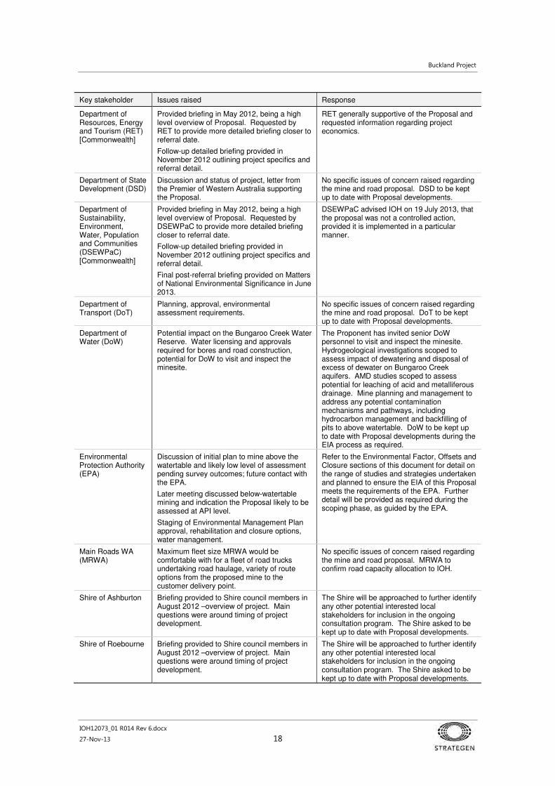
Buckland Project
IOH12073_01 R014 Rev 6.docx
27-Nov-13 18
Key stakeholder Issues raised Response
Department of Resources, Energy and Tourism (RET) [Commonwealth]
Provided briefing in May 2012, being a high level overview of Proposal. Requested by RET to provide more detailed briefing closer to referral date.
Follow-up detailed briefing provided in November 2012 outlining project specifics and referral detail.
RET generally supportive of the Proposal and requested information regarding project economics.
Department of State Development (DSD)
Discussion and status of project, letter from the Premier of Western Australia supporting the Proposal.
No specific issues of concern raised regarding the mine and road proposal. DSD to be kept up to date with Proposal developments.
Department of Sustainability, Environment, Water, Population and Communities (DSEWPaC) [Commonwealth]
Provided briefing in May 2012, being a high level overview of Proposal. Requested by DSEWPaC to provide more detailed briefing closer to referral date.
Follow-up detailed briefing provided in November 2012 outlining project specifics and referral detail.
Final post-referral briefing provided on Matters of National Environmental Significance in June 2013.
DSEWPaC advised IOH on 19 July 2013, that the proposal was not a controlled action, provided it is implemented in a particular manner.
Department of Transport (DoT)
Planning, approval, environmental assessment requirements.
No specific issues of concern raised regarding the mine and road proposal. DoT to be kept up to date with Proposal developments.
Department of Water (DoW)
Potential impact on the Bungaroo Creek Water Reserve. Water licensing and approvals required for bores and road construction, potential for DoW to visit and inspect the minesite.
The Proponent has invited senior DoW personnel to visit and inspect the minesite. Hydrogeological investigations scoped to assess impact of dewatering and disposal of excess of dewater on Bungaroo Creek aquifers. AMD studies scoped to assess potential for leaching of acid and metalliferous drainage. Mine planning and management to address any potential contamination mechanisms and pathways, including hydrocarbon management and backfilling of pits to above watertable. DoW to be kept up to date with Proposal developments during the EIA process as required.
Environmental Protection Authority (EPA)
Discussion of initial plan to mine above the watertable and likely low level of assessment pending survey outcomes; future contact with the EPA.
Later meeting discussed below-watertable mining and indication the Proposal likely to be assessed at API level.
Staging of Environmental Management Plan approval, rehabilitation and closure options, water management.
Refer to the Environmental Factor, Offsets and Closure sections of this document for detail on the range of studies and strategies undertaken and planned to ensure the EIA of this Proposal meets the requirements of the EPA. Further detail will be provided as required during the scoping phase, as guided by the EPA.
Main Roads WA (MRWA)
Maximum fleet size MRWA would be comfortable with for a fleet of road trucks undertaking road haulage, variety of route options from the proposed mine to the customer delivery point.
No specific issues of concern raised regarding the mine and road proposal. MRWA to confirm road capacity allocation to IOH.
Shire of Ashburton Briefing provided to Shire council members in August 2012 –overview of project. Main questions were around timing of project development.
The Shire will be approached to further identify any other potential interested local stakeholders for inclusion in the ongoing consultation program. The Shire asked to be kept up to date with Proposal developments.
Shire of Roebourne Briefing provided to Shire council members in August 2012 –overview of project. Main questions were around timing of project development.
The Shire will be approached to further identify any other potential interested local stakeholders for inclusion in the ongoing consultation program. The Shire asked to be kept up to date with Proposal developments.
Buckland Project
IOH12073_01 R014 Rev 6.docx
27-Nov-13 19
Key stakeholder Issues raised Response
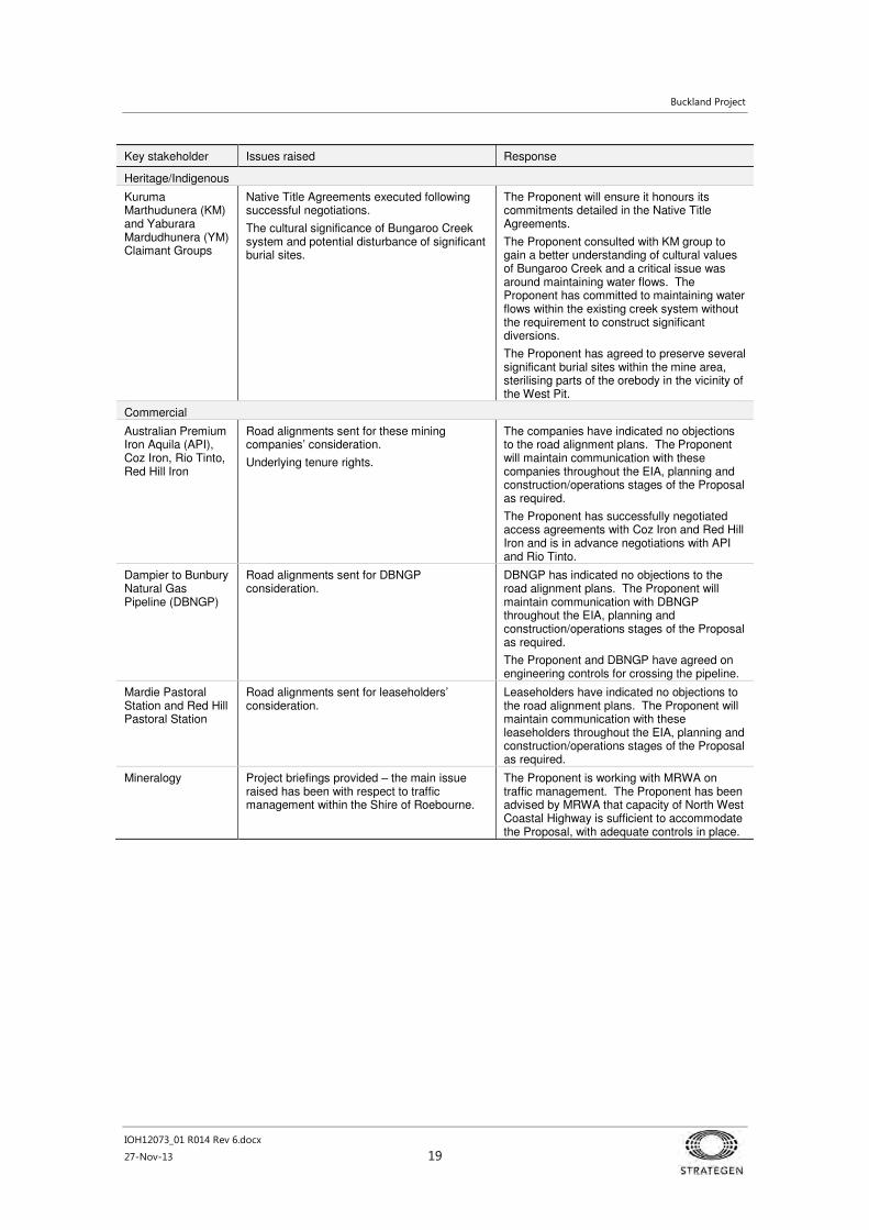
Heritage/Indigenous
Kuruma Marthudunera (KM) and Yaburara Mardudhunera (YM) Claimant Groups
Native Title Agreements executed following successful negotiations.
The cultural significance of Bungaroo Creek system and potential disturbance of significant burial sites.
The Proponent will ensure it honours its commitments detailed in the Native Title Agreements.
The Proponent consulted with KM group to gain a better understanding of cultural values of Bungaroo Creek and a critical issue was around maintaining water flows. The Proponent has committed to maintaining water flows within the existing creek system without the requirement to construct significant diversions.
The Proponent has agreed to preserve several significant burial sites within the mine area, sterilising parts of the orebody in the vicinity of the West Pit.
Commercial
Australian Premium Iron Aquila (API), Coz Iron, Rio Tinto, Red Hill Iron
Road alignments sent for these mining companies’ consideration.
Underlying tenure rights.
The companies have indicated no objections to the road alignment plans. The Proponent will maintain communication with these companies throughout the EIA, planning and construction/operations stages of the Proposal as required.
The Proponent has successfully negotiated access agreements with Coz Iron and Red Hill Iron and is in advance negotiations with API and Rio Tinto.
Dampier to Bunbury Natural Gas Pipeline (DBNGP)
Road alignments sent for DBNGP consideration.
DBNGP has indicated no objections to the road alignment plans. The Proponent will maintain communication with DBNGP throughout the EIA, planning and construction/operations stages of the Proposal as required.
The Proponent and DBNGP have agreed on engineering controls for crossing the pipeline.
Mardie Pastoral Station and Red Hill Pastoral Station
Road alignments sent for leaseholders’ consideration.
Leaseholders have indicated no objections to the road alignment plans. The Proponent will maintain communication with these leaseholders throughout the EIA, planning and construction/operations stages of the Proposal as required.
Mineralogy Project briefings provided – the main issue raised has been with respect to traffic management within the Shire of Roebourne.
The Proponent is working with MRWA on traffic management. The Proponent has been advised by MRWA that capacity of North West Coastal Highway is sufficient to accommodate the Proposal, with adequate controls in place.

Buckland Project
IOH12073_01 R014 Rev 6.docx
27-Nov-13 20
4. Environmental impacts and management
4.1 Approach
This chapter provides a summary of the environmental factors potentially relevant to the assessment of
impacts of this Proposal. The factors and issues listed have been based primarily on the Category A –
EPA-prepared scoping guideline issued for this Proposal on 12 February 2013. Secondary consideration
has been given to guidance from relevant agencies, the results of relevant regional studies, as well the
experience and advice of IOH personnel and the range of specialist consultants engaged for the Proposal.
The environmental factors have been separated into two groups:
1. Key factors: Those environmental factors of elevated significance, which require the most attention in
the EIA process. The key factors are as follows:
• inland waters environmental quality
• hydrological processes
• flora and vegetation
• terrestrial fauna
• subterranean fauna.
2. Other potential impacts or activities: Those environmental factors and issues of lesser importance
recognised as potentially requiring consideration and management. Other factors or issues which
have been identified include:
• greenhouse gas emissions
• Aboriginal heritage
• air quality (dust)
• hazardous materials
• rehabilitation and closure
• noise and vibration
• public risk and safety
• non-mineral waste.
The following sections describe and discuss these factors. The information has been set out in tabular
form, as prescribed by the Prepared Scoping Guideline issued to the Proponent by the EPA (2013).
4.2 Environmental impact assessment tables
Studies planned and undertaken
A number of studies have been commissioned by the Proponent in order to understand the environmental
values within the Proposal area. These studies are summarised in Table 9.
Studies timeline
Table 10 summarises when studies to support the Proposal EIA were undertaken and completed.
Compliance of studies with EPA guidance
Table 11 lists the EPA Guidance Statements, Environmental Assessment Guidelines and/or Policies
applicable to the Proposal and how these have been addressed.

Buckland Project
IOH12073_01 R014 Rev 6.docx
27-Nov-13 21
Key findings
Table 12 provides a brief summary of the key findings for each factor. Further detail is presented in
Section 4.3 and the technical documents in Appendix 2.
Key environmental impacts and management
Section 4.3 presents the assessment of the impact of the Proposal on key environmental factors, with a
summary of aspects and potential impacts, proposed management and mitigation measures to address
the identified impacts and conclusion of predicted outcome against the EPA objective or objectives for that
factor.
Management commitments
Section 4.4 presents a consolidated description of the environmental management approaches and
actions for the IOH Buckland Project.

Buckland Project
IOH12073_01 R014 Rev 6.docx
27-Nov-13 22
Table 9 Planned and completed studies for the Buckland Project
Factor Consultant Study effort Study location Planned / complete
Report
Inland waters environmental quality
RPS Aquaterra Baseline hydrogeology and groundwater chemistry.
Bungaroo South deposits Complete Bungaroo South pre Feasibility Dewatering Assessment (RPS 2012b)
Contaminant transport (groundwater modelling).
Minesite and surrounds Complete Bungaroo South – Numerical Modelling of the Impacts of Mining on the Hydrogeology (RPS 2013a)
Excess water disposal options assessment.
Minesite and surrounds Complete Buckland Project: Bungaroo South Excess Water Disposal Options Assessment (RPS 2013b)
Waste Rock Dump water balance assessment.
Minesite Complete Buckland Mining Project - Water Balance Assessment for the Waste Dumps (RPS 2013d)
Expanded contaminant transport modelling (incorporating results of kinetic tests).
Minesite and surrounds As kinetic test results become available
TBA
URS Waste characterisation studies of waste rock and other materials using static testing, including acid and metalliferous drainage (AMD) risk assessment.
Minesite and surrounds Complete Bungaroo South and Dragon Project, Soils and Landforms Preliminary Study (URS 2012).
Acid and Metalliferous Drainage Assessment, Buckland Project – Updated final version (URS 2013).
Completion of AMD risk assessment by kinetic testing and contaminant transport modelling.
Minesite and surrounds Planned: to be completed within first two years of mining
TBA
Tetra Tech Order of magnitude Waste Fines Storage Facility water balance.
Minesite Complete Bungaroo South: Order of Magnitude WFSF Water Balance (Rev 2) (Tetra Tech 2013).
Hydrological processes
RPS Aquaterra Pre-feasibility study of surface water management options.
Bungaroo South deposits (east and west) Complete South Bungaroo Project Surface Water Assessment (RPS 2012a).
Prefeasibility-level dewatering assessment.
Bungaroo South deposits (east and west) Complete Bungaroo South pre Feasibility Dewatering Assessment (RPS 2012b).
Review of previous groundwater investigations in the area.
NA - regional Complete
Groundwater modelling to refine dewatering and drawdown estimates.
Minesite and surrounds Complete
Assessment of groundwater systems Haul road corridor Complete
Conceptual hydrogeological model and calibrated numerical hydrogeological modelling to define dewatering and drawdown estimates and particle tracking assessment
Minesite and surrounds Complete Bungaroo South – Numerical Modelling of the Impacts of Mining on the Hydrogeology (RPS 2013a)

Buckland Project
IOH12073_01 R014 Rev 6.docx
27-Nov-13 23
Factor Consultant Study effort Study location Planned / complete
Report
Detailed numerical model to confirm dewatering estimates and particle tracking predictions
Minesite and surrounds 2014 TBA
Excess water disposal options assessment
Minesite and surrounds Complete Buckland Project: Bungaroo South Excess Water Disposal Options Assessment (RPS 2013b)
SKM River crossing drainage design criteria Robe River crossing Complete Buckland Project Robe River Crossing Drainage Design Criteria Report (SKM 2013).
Flora and vegetation
Onshore Environmental
Two-season Level 2 survey. Bungaroo south-east and west deposits, Dragon deposit, infrastructure area.
Complete Flora and Vegetation Survey, Buckland and Snake Projects (Onshore 2013a)
Two-season Level 2 survey. 36 km section of the Stage 1[1] road corridor from Bungaroo South to the API Rail Head.
Complete Flora and Vegetation Survey, Bungaroo South to API Rail Head (Onshore 2013b)
Desktop assessment. API Rail Head to Cape Preston Stage 2 road corridor.
Complete Literature and Desktop Review – Flora and Vegetation – Proposed Cape Preston Transport Corridor (Onshore 2013c)
Desktop assessment. Minesite and surrounds Complete Bungaroo South Iron Ore Mine – Groundwater Dependent Flora and Vegetation, Impact Assessment (Onshore 2013d)
Level 2 survey. API Rail Head to NWCH Stage 2 road corridor.
Complete Level 2 Flora and Vegetation Survey API Rail Head to North West Coastal Highway (Onshore 2013e)
Terrestrial fauna (vertebrate fauna)
Phoenix Environmental Sciences
Level 1 terrestrial vertebrate fauna survey.
Bungaroo South and Dragon mine areas. Complete Terrestrial fauna surveys for the Buckland Project (Phoenix 2012a)
Targeted survey for conservation significant fauna.
Bungaroo South and Dragon mine areas. Complete Targeted Vertebrate Fauna Surveys for the Buckland Project (Phoenix 2012b)
Regional targeted Northern Quoll survey. Bungaroo South and Dragon areas as well as the four large drainage channels to the west and south of the development envelope.
Complete

Buckland Project
IOH12073_01 R014 Rev 6.docx
27-Nov-13 24
Factor Consultant Study effort Study location Planned / complete
Report
Level 1 and targeted terrestrial vertebrate fauna survey.
First section of Stage 12 road corridor from Bungaroo South to the API Rail Head. Habitat outside the corridor was also investigated where it was likely to be connected to habitat within the corridor.
Complete Terrestrial Fauna Survey for the Buckland Project Haul Road (Phoenix 2012c)
Desktop assessment utilising data collected in areas already surveyed by other Proponents that are in proximity to the Proposal area.
API Rail Head to Cape Preston Stage 23 road corridor.
Complete Level 1 terrestrial fauna survey for the Buckland Project Stage 2 haul road (Phoenix 2013a)
Targeted survey API Rail Head to Cape Preston Stage 2 road corridor.
Complete (Draft) Terrestrial Fauna Survey for the Buckland Project Haul Road (Phoenix 2013b)
RPS Aquaterra Surface water impacts on quoll habitat Minesite Complete Site Bungaroo South – Surface water impacts on quoll habitat (RPS 2013c)
Terrestrial fauna (short-range endemic invertebrates)
Phoenix Environmental Sciences
Short-range endemic invertebrate survey. Bungaroo South and Dragon areas. Complete Terrestrial fauna surveys for the Buckland Project (Phoenix 2012a)
Short-range endemic invertebrate survey. First section of Stage 1 haul road corridor from Bungaroo South to the API Rail Head. Habitat outside the corridor was also investigated where it was likely to be connected to habitat within the corridor.
Complete Terrestrial Fauna Survey for the Buckland Project Haul Road (Phoenix 2012c)
Desktop assessment API Rail Head to Cape Preston Stage 2 road corridor.
Complete Level 1 terrestrial fauna survey for the Buckland Project Stage 2 haul road (Phoenix 2013a)
Subterranean fauna
Bennelongia First and second phase troglofauna and stygofauna study.
Troglofauna samples collected within, and at reference sites outside, the proposed pits at South Bungaroo West, East and Dragon. Stygofauna samples collected from vicinity of proposed pits at Bungaroo South West, Bungaroo Southeast and Dragon.
Complete Bungaroo South: Subterranean Fauna Assessment, (Bennelongia 2013)
2
Phoenix has used the term ‘Stage 1 haul road’ to refer to the section of the haul road from the Bungaroo South mine area to a location associated with the site of a future rail head proposed by Australian Premium Iron Pty Ltd (API). ‘Stage 1’ refers to the Stage of the fauna survey, rather than the Stage of project development.
3
Phoenix uses ‘Stage 2’ to refer to the section of the haul road from the API railhead to North West Coastal Highway. ‘Stage 2’ refers to the Stage of the survey, rather than the Stage of project development.

Buckland Project
IOH12073_01 R014 Rev 6.docx
27-Nov-13 25
Table 10 Supporting studies timeline
Factor/study 2012 2013 2014 2015
Q1 Q2 Q3 Q4 Q1 Q2 Q3 Q4 Q1 Q2 Q3 Q4 Q1
Prefeasibility-Level dewatering assessment
Review of previous groundwater investigations
Groundwater modelling to refine dewatering and drawdown estimates
Conceptual hydrogeological model, calibrated numerical hydrogeological modelling, particle tracking assessment
Excess water disposal options assessment
Assessment of groundwater systems
Acid mine drainage assessment Kinetic
Order of Magnitude WFSF Water Balance
Vegetation and flora
Two-season Level 2 survey – Mine area
Vegetation and flora
Two-season Level 2 survey – 36 km section of the Stage 1 road corridor from Bungaroo South to the API Rail Head
Vegetation and flora
Desktop Assessment – API Rail Head to Cape Preston
Vegetation and flora
Level 2 survey –Stage 1 road corridor from API to NWCH
Terrestrial fauna
Short-range endemic invertebrate survey
Level 1 terrestrial vertebrate fauna survey
Targeted survey for conservation significant fauna survey
Regional targeted Northern Quoll survey
Level 2 Veg and Flora – API to NWCH Haul Rd
Targeted vertebrate fauna – API to NWCH Haul Rd
Subterranean fauna
Stakeholder consultation
Field work Studies

Buckland Project
IOH12073_01 R014 Rev 6.docx
27-Nov-13 26
Table 11 Compliance of studies with EPA Guidance and Position Statements
Relevant position and guidance statements How addressed
Environmental Assessment Guideline No. 1 – Defining the Key Characteristics of a Proposal.
The Proposal description as provided in Section 2 (particularly the table of key characteristics [Table 2]), and in Figure 2 and Figure 3.
Environmental Assessment Guideline No. 6 – Timelines for Environmental Impact Assessment of Proposal.
N/A – guidance is primarily to define timeline targets. The IOH role in meeting targeted timelines is to provide adequate information to allow assessment of the proposal by the EPA.
EPA Guidance Statement No. 51 – Terrestrial Flora and Vegetation Surveys for Environmental Impact Assessment in Western Australia. (GS 51).
Level 1 and 2 surveys were undertaken in accordance with GS 51.
EPA Guidance Statement No. 56 – Terrestrial Fauna Surveys for Environmental Impact Assessment in Western Australia. (GS 56).
Terrestrial and short-range endemic fauna surveys conducted for the Proposal were undertaken in accordance with GS 56.
EPA Position Statement No. 2 – Environmental Protection of Native Vegetation in Western Australia: Clearing of Native Vegetation with Particular Reference to Agricultural Areas (Position Statement No. 2).
Flora and vegetation surveys adhered to the requirements of Position Statement No. 2.
EPA Position Statement No. 3 – Terrestrial Biological Surveys as an element of Environmental Protection (Position Statement No. 3).
Vertebrate fauna surveys, short-range endemic fauna surveys and flora and vegetation surveys adhered to the requirements of Position Statement No. 3.
Technical guide – Terrestrial Vertebrate Fauna Surveys for Environmental Impact Assessment (Technical Guide)
The vertebrate fauna surveys adhered to the principles and practices of the Technical Guide.
EPA Guidance Statement No. 6 – Rehabilitation of Terrestrial Ecosystems. (GS 6)
DMP/EPA Guidelines for Preparing Mine Closure Plans.
Rehabilitation and closure will be addressed through detailed rehabilitation and closure planning to be undertaken as part of the Mining Proposal required under the Mining Act 1978 (Table 19). A key objective of rehabilitation and closure planning will be to ensure the return of rehabilitated areas to self-sustaining and functional ecosystems comprised of local provenance species, in accordance with GS 6.
A Closure and Decommissioning Plan (Closure Plan) will be prepared to satisfy the requirements of the ANZMEC/MCA Strategic Framework for Mine Closure (ANZMEC/MCA 2000). This will be based on the methodology and approaches outlined in the DMP/EPA Guidelines for Preparing Mine Closure Plans (DMP and EPA 2011) and the Department of Industry, Tourism and Resources (DITR) Leading Practice Sustainable Development in Mining (DITR 2008) handbooks and the Planning for Integrated Mine Closure: Toolkit (ICMM 2008).
EPA Guidance Statement No. 20 – Sampling of Short Range Endemic Invertebrate Fauna for Environmental Impact Assessment in Western Australia. (GS 20).
Short-range endemic fauna surveys conducted for the Proposal were undertaken in accordance with GS 20.
EPA Guidance Statement No. 54 – Consideration of Subterranean Fauna in Groundwater and Caves during EIA in WA. (GS 54)
EPA Guidance Statement No. 54a – Sampling methods and survey considerations for subterranean fauna in Western Australia. (GS 54a).
First and second phase troglofauna and stygofauna studies were undertaken in accordance with GS 54 and GS 54a.
EPA Guidance Statement No. 19 – Environmental Offsets (GS 19)
Environmental Protection Bulletin No. 1 – Environmental Offsets – Biodiversity (EPB 1).
GS 19 and EPB 1 define offsets and the criteria and guiding principles for proponents to consider and follow when developing an offsets package. These are addressed in Section 7. The key principle of ‘avoiding and minimising’ impact first is addressed in the summary provided in Section 2.6 regarding alternatives considered.
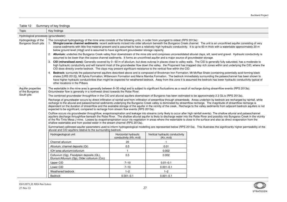
Buckland Project
IOH12073_01 R014 Rev 6.docx
27-Nov-13 27
Table 12 Summary of key findings
Topic Key findings
Hydrological processes (groundwater)
Hydrogeology of the Bungaroo South pits
The conceptual hydrogeology of the mine area consists of the following units, in order from youngest to oldest (RPS 2013a): 1. Shingle/coarse channel sediments: recent sediments incised into older alluvium beneath the Bungaroo Creek channel. The unit is an unconfined aquifer consisting of very
coarse sediments with little fine material present and is assumed to have a relatively high hydraulic conductivity. It is up to 60 m thick with a watertable approximately 20 m
below ground level (mbgl) and is assumed to have significant groundwater storage capacity.
2. Alluvium: underlies the Bungaroo Creek valley floor downstream of the mine site and comprises unconsolidated alluvial clays, silt, sand and gravel. Hydraulic conductivity is
assumed to be lower than the coarse channel sediments. It forms an unconfined aquifer and a major source of groundwater storage.
3. CID (mineralised zone): Generally covered by 0– 60 m of alluvium, but does outcrop in places close to valley walls. The CID is generally fully saturated, has a moderate to
high hydraulic conductivity and will transmit most of the groundwater flow down the valley. the Proponent has mapped clay rich zones within and underlying the CID, where the
CID does directly overlie bedrock. The clays may present significant resistance to the vertical flow within the CID.
4. Bedrock: surrounds the palaeochannel aquifers described above and is composed of Brockman Iron Formation, Mt McRae Shale (containing potentially acid-forming black
shales [URS 2013]), Mt Sylvia Formation, Wittenoom Formation and Marra Mamba Formation. The bedrock immediately surrounding the palaeochannel has been shown to
have higher hydraulic conductivities than might be expected for weathered bedrock. Away from this zone it is assumed the bedrock has lower hydraulic conductivity typical of
other locations in the Pilbara.
Aquifer properties of the Bungaroo South pits
The watertable in the mine area is generally between 8–30 mbgl and is subject to significant fluctuations as a result of recharge during streamflow events (RPS 2013a). Groundwater flow is generally in a northwest direct towards the Robe River.
The combined groundwater throughflow in the CID and alluvial aquifers downstream of Bungaroo has been estimated to be approximately 2.3 GL/a (RPS 2013a).
Recharge of groundwater occurs by direct infiltration of rainfall and from infiltration of streamflow through streambeds. Areas underlain by bedrock are recharged by rainfall, while recharge to the alluvial and palaeochannel sediments underlying the Bungaroo Creek valley is dominated by streamflow recharge. The magnitude of streamflow recharge is dependent on the duration of streamflow and the available storage of the aquifer in the vicinity of the creek. Recharge to the valley sediments from adjacent bedrock aquifers is not expected to be significant, compared to recharge from stream flow events (RPS 2013a).
Outflow occurs via groundwater throughflow, evapotranspiration and leakage into streams (only likely to occur after high rainfall events). The shallow alluvial and palaeochannel aquifers discharge throughflow beneath the Robe River. The shallow alluvial aquifer is likely to discharge water into the Robe River and possibly into Bungaroo Creek in the vicinity of the Rio Tinto Mesa J mine. Losses by evapotranspiration occur via vegetation in areas where the watertable is close to the surface and also as direct evaporation from the shallow watertable and from pooled water in the stream channel (RPS 2013a).
Summarised calibrated aquifer parameters used to inform hydrogeological modelling are represented below (RPS 2013a). This illustrates the significantly higher permeability of the alluvial and CID aquifers relative to the surrounding bedrock.
Hydrogeological unit Horizontal hydraulic conductivity (Kh; m/d)
Vertical hydraulic conductivity (Kv; m/d)
Channel alluvium 20 1
Alluvium, channel deposits (Qr) 0.5 0.01
IOH area alluvium/colluvium 1 0.002
Colluvium (Qg), Floodplain deposits (QL), Eluvium/Alluvium (Qp), Older colluvium (Czc)
0.5 0.002
Upper CID 7–10 0.01–0.1
Lower CID 7–10 0.001–0.1
Weathered bedrock 1–2 1–2
Bedrock 0.001–0.1 0.001–0.1

Buckland Project
IOH12073_01 R014 Rev 6.docx
27-Nov-13 28
Topic Key findings
Dewatering requirements for Bungaroo South pits and mine water balance
Prediction of dewatering requirements was based on three cases, covering different rainfall and water management scenarios:
Case 1: Dewatering of Bungaroo West and East Pits; no recharge from Bungaroo Creek (i.e. no to low rainfall during the mine life, consider the least likely of the scenarios).
Case 2: Dewatering of Bungaroo West and East Pits; recharge from Bungaroo Creek.
Case 3: Dewatering of Bungaroo West and East Pits; recharge from Bungaroo Creek; reinjection of excess dewater; Bungaroo Coastal Water Supply project abstraction included.
Water will be required approximately two years prior to the commencement of mining for construction of the haul road and the mine site. Access below the watertable to facilitate dry mining conditions will be required for approximately seventeen of the estimated nineteen years of mining, commencing in year two. It is proposed to dewater using bores located on the perimeter of the West and East pits with dewater supply used to meet the Proposal water demand where possible. When dewatering exceeds water supply requirements, the excess will require disposal. At the end of mining and pit backfilling, dewatering will cease. Groundwater levels will then recover to a final or equilibrium level in the dewatered areas (RPS 2013a).
Prediction results also found that the dewatering requirements will exceed the projected water supply requirements and disposal of excess water will be required for most of the life of the mine (i.e. from the approximately the third year of mining to closure). Dewatering and disposal is predicted to peak at approximately 4.75 GL/a and 4.5 GL/a respectively in the third year of mining (first year of mining below the watertable) and then gradually decrease (variably – cyclone events will result in result in short term spikes that may require addition in-pit removal of surface water due to flood events collecting at the bottom of the pit). Demand will exceed supply in approximately year 12 and in the final year of mining. Additional dewatering and disposal was indicated in years 6 to 9 at the Bungaroo South West Pit, and years 15 and 18 at the East Pit (RPS 2013a).
Dewatering of the two Bungaroo South pits would cause a gradual elongated cone of depression constrained within the palaeochannel and its tributaries. Maximum drawdown of approximately 85 m at the West Pit will occur after ten years from commencement of mining and continue until closure. Maximum drawdown of 145 m is predicted to occur at the East Pit at the end of mining. The drawdown cone (5 m drawdown contour) will extend approximately 6 km downstream from the West Pit and no more than 4 km upstream of the East Pit. Abstraction from the proposed Bungaroo Coastal Water Supply borefield is expected to be in the order of 10 GL/a, which will result in its own drawdown cone within the palaeochannel, predicted to be a maximum of 40 m at its borefield.
See below (Inland waters [environmental quality]) for discussion regarding the proposed Bungaroo Coastal Water Supply and Bungaroo Creek Water Reserve.

Buckland Project
IOH12073_01 R014 Rev 6.docx
27-Nov-13 29
Topic Key findings
Acid and metalliferous mine drainage
Samples from waste rock and ore lithologies as well as waste fines at the Buckland Project were subjected to Acid Base Accounting (ABA), multi-element solids and leachate analyses as part of the preliminary geochemical assessment of the materials. This analysis was conducted to assess the potential for the samples materials to generate acid and metalliferous drainage (URS 2013).
Waste rock and ore material
All waste rock and ore material samples, with the exception of black shale samples, had total sulfur values below 0.1%S, were classified as Barren and thus unlikely to generate acid drainage resulting in an environmental impact (URS 2013).
Waste rock and ore material tested did not exceed WA DEC interim sediment quality guideline (ISQG) low or high trigger values for soils and sediments for the majority of metals. Exceptions were Arsenic (As), Chromium (Cr), Copper (Cu), Mercury (Hg), Nickel (Ni), Antimony (Sb) and Zinc (Zn). These metals and metalloids are commonly found enriched in the vicinity of iron ore deposits in the Pilbara.
Results of leachate testing on waste rock and ore samples complied with Australian Drinking Water Guidelines (NHMRC/NRMMC 2011) for all metals with the exception of aluminium, with most samples (and also baseline groundwater samples) exceeding the guideline value of 0.1 mg/L (URS 2013).
Black Shales
Preliminary information indicates the risks associated with the potential generation of AMD are mainly associated with black shale lithologies. Black shales are not proposed to be disturbed by the physical mining process of the Buckland Project; however, there is potential for the black shales to be disturbed by dewatering (URS 2013).
Waste fines
Six samples of waste fines from wet processing pilot studies were submitted for laboratory analysis, along with supernatant from the process. Test results from one of the supernatant samples (Pilot study 1) were markedly inconsistent with the leachate results and the geochemistry of the fines themselves, and were not reproduced in a second supernatant sample derived from the same fines. Following analyses of an additional 5 independent samples, which show little variation, the results of the first test have been determined to be unreliable and removed from the current dataset (URS 2013).
The waste fine samples had total sulfur values below 0.1%S - classified as Barren. The samples did not exceed WA DEC ISQG low or high trigger values for soils and sediments for all metals, except Sb, which was reported marginally above the ISQG low trigger value. Leachate testing indicated that the waste fines had concentrations below the ANZECC/ARMCANZ ecological trigger values for all metals and metalloids except Al and Zn. All six leachate and supernatant sample results were within Australian Drinking Water Guidelines (NHMRC/NRMMC 2011) for pH, metals and major ions (URS 2013).
WFSF water balance (Tetra Tech 2013)
The Waste Fines Storage Facility will be composed of two adjacent ponds. The water balance study was based on inflows from direct rainfall, catchment runoff, water from the waste fines slurry and outflows from evaporation and seepage. The study found the maximum amount of return water that can be pumped from the WFSF based on average climatic conditions for Pond 1 is 16.4 L/s (approximately 0.5 GL/a) and the average return water rate is approximately 4.7 L/s (approximately 0.15 GL/a). In Years 4–6 there are months where the return water volume is less than zero, typically at the end of the dry season where there has been 4 months of zero precipitation and reduced inflow. The average seepage rate from Pond 1 to 2.2 L/s (0.07 GL/a).
The maximum return flow rate for Pond 2 is 19.7 L/s (0.62 GL/a), and the average return water rate is approximately 4.3 L/s (0.14 GL/a). The average flow rate for Pond 2 is lower than Pond 1 because there are more months of no return flow in Years 3–6 compared to Pond 1. The average seepage rate from Pond 2 is 2.5 L/s (0.08 GL/a).
The combined average seepage rate from both ponds is 0.15 GL/a.
If a wet year occurs during mining operations, the maximum return flow rate increases two to threefold, the reverse if a dry year occurs (i.e. return flow rates are highly sensitive to precipitation). No storm events from cyclones or tropical lows were simulated.

Buckland Project
IOH12073_01 R014 Rev 6.docx
27-Nov-13 30
Topic Key findings
Hydrological processes (surface water)
Hydrology of the Proposal area
It is not uncommon for base flow to be uneven or non-existent in Pilbara creek systems, with many years of no, or extremely low, flow interspersed by periods of relatively high flow. This flow variability may be attributable to either one-off large events typically associated with cyclones, or multiple smaller events in the form of fronts and rain depressions (RPS 2013a).
Bungaroo South deposits are located across Bungaroo Creek and its tributaries (RPS 2012a) (Figure 2). The 100-year average recurrence interval (ARI) flow for the overall Bungaroo Creek catchment was estimated at 886 m³/s, with a theoretical maximum flow estimated at ten times this figure (i.e. 8800 m3/s). Over a 20 year mine life, there is a 20% chance that the 100-year ARI flow event may occur. A significant flow event such as a 10 year event would have about a 90% chance of occurring. On this basis the 100-year ARI flow event levels, with freeboard, has been used to inform bund design (RPS 2012a).
The proposed haul road alignment will involve two crossings of two significant ephemeral surface water features: the Robe River and Fortescue River (Figure 3).
Inland waters (environmental quality)
Bungaroo Creek Water Reserve
The Bungaroo Coastal Water Supply Borefield (BCWSB) is being developed by Rio Tinto as part of its planned expansion of operations in the Pilbara. The borefield is located in the lower Bungaroo Valley and will have an annual capacity of 10 GL, from which bulk water will be supplied to Karratha, Dampier, Roebourne, Cape Lambert and Point Samson. The borefield consists of nine production bores within the Bungaroo Creek palaeochannel (RPS 2012b).
The Bungaroo Creek Water Reserve is planned to protect the water source and catchment areas that are responsible for aquifer recharge and the reserve boundary encompasses the deposits that are subject of the Proposal. DoW has recommended the water reserve be managed for Priority 1 source protection, with 500 m wellhead protection zones established around all production bores (RPS 2012b).
DoW indicates mining proposals within the proposed water reserve are compatible, with conditions (i.e., associated with EPA and/or DMP approvals), and should be guided by DoW water quality protection guidelines (DoW 2012).
Priority 1 (P1) classification areas are managed to ensure that there is no degradation of the drinking water source by preventing development of potentially harmful activities in these areas. The guiding principle is risk avoidance and this is the most stringent priority classification for drinking water sources (DoE 2004).
The Proponent will continue to consult DoW during the environmental impact assessment and approvals process to address potential impacts of the Proposal on the Bungaroo Creek Water Reserve.
Note, hydrogeological and hydrological reports and data related to the Bungaroo Coastal Water Supply was not made available to the Proponent on request. This may have limited the accuracy of modelling undertaken to support the EIA.
Flora and vegetation
Historical mapping Sixteen land systems (Van Vreeswyk et al. 2004) occur within the Proposal development envelope. These are described in Onshore 2013a, 2013b and 2013c. Of these land systems, Newman accounts for over 50% of the development envelope and the remaining land systems comprise less than 10%. The extent of each of these land systems in the development envelope, relative to the mapped extent in the Pilbara, is small.
Shepherd et al. (2002) refined historical systematic flora mapping of the Pilbara originally completed by Burbidge (1959) and Beard (1975), providing pre-European extent of vegetation associations and sub-associations. Five vegetation associations comprising 19 sub-associations have been mapped across the Proposal area; these are described in Onshore (2013a, 2013b and 2013c). These associations are well distributed with a low risk of significant effects as a result of the Proposal (Onshore 2013a, 2013b and 2013c).
Vegetation surveys by Onshore
Buckland (mine) survey area (Onshore 2013a)
Nine vegetation units from seven broad floristic formations were identified within the Bungaroo South and Dragon deposit (Buckland) survey area (Figure 23). Vegetation condition ranged from good to excellent. Drainage lines and floodplains were in comparatively poorer condition due to impacts associated with stock grazing and weed invasion.
No Threatened Ecological Communities (TECs) or Priority Ecological Communities (PECs) occur within, or adjacent to the Buckland survey area. Five PECs occur within a 90 km radius of the Buckland survey area (Onshore 2013a), two of which are vegetation communities (the remainder are invertebrate assemblages). The vegetation related PECs are known as, Triodia sp. Robe River assemblages of mesas of the West Pilbara (Priority 3) and Sand Sheet vegetation (Robe Valley) (Priority 1).

Buckland Project
IOH12073_01 R014 Rev 6.docx
27-Nov-13 31
Topic Key findings
Haul Road: Stage 1 (BS to API Rail Head) (Onshore 2013b)
Twenty-seven vegetation units from eleven broad floristic formations were identified within the Bungaroo South to API Rail Head (Stage 1) survey area. The majority of the survey area was in pristine or excellent condition with drainage lines and floodplains tending to be in a comparatively poorer condition due to impacts associated with stock grazing and the presence of weed species.
No TECs or PECs occur within, or adjacent to the Stage 1 survey area. Four PECs occur within a 100 km radius of survey area (Onshore 2013b). Of these, the only vegetation-related PEC (the remainder are invertebrate assemblages) is the Triodia sp. Robe River assemblages of the mesas of the West Pilbara (Priority 3).
Haul Road: Stage 1 (API Rail Head to NWCHWY) (Onshore 2013d) with alternatives mapped at L1 only (Onshore 2013c)
A total of 24 vegetation associations were described and mapped from the study area. The vegetation associations were classified into eleven Broad Floristic Formations on the basis of canopy structure. None of the vegetation associations are affiliated with any Commonwealth listed TECs and as such, vegetation is not determined to be significant at a Commonwealth level. At a State level, there were no Threatened Flora or TECs (as listed under the WC Act) recorded from the study area, nor were any of the vegetation associations determined to be representative of any State listed PECs. However, two Priority 3 flora taxa were recorded from the southern sector of the study area; Triodia sp. Robe River (M.E. Trudgen et al. MET12367) and Indigofera sp. Bungaroo Creek (S. van Leeuwen 4301). Two vegetation associations within the study area support Triodia sp. Robe River (M.E. Trudgen et al. MET12367) (Vegetation associations 10e and 10h) and Vegetation association 10g supports Indigofera sp. Bungaroo Creek (S. van Leeuwen 4301); both taxa are restricted to the southern end of the study area. These three vegetation associations are determined to be of local significance.
Flora Buckland (mine) survey area (Onshore 2013a)
186 plant taxa from 97 genera and 44 families were recorded within the Buckland survey area. No Threatened or listed flora species pursuant to the Wildlife Conservation Act 1950 (WC Act) or EPBC Act were recorded. Four Priority flora taxa were recorded within the survey area: • Indigofera sp. Bungaroo Creek (P3)
• Sida sp. Barlee range (P3)
• Triodia sp. Robe River (P3)
• Rhynchosia bungarensis (P4).
All four Priority taxa were found at the Bungaroo South deposits. The only Priority taxon recorded at the Dragon deposit and infrastructure areas was Triodia sp. Robe River (P3). This species was typically found as scattered individuals on plateau slopes, minor drainage lines, ravines and gullies.
Haul Road: Stage 1 (BS to API Rail Head) (Onshore 2013b)
131 plant taxa from 60 genera and 28 families were recorded during the first season survey of the Stage 1 haul road survey area. No Threatened or listed flora species pursuant to WC Act or listed under the EPBC Act were recorded. Three Priority flora taxa were recorded within the survey area: • Indigofera sp. Bungaroo Creek (P3)
• Triodia sp. Robe River (P3)
• Rhynchosia bungarensis (P4).
Haul Road: Stage 1 (API Rail Head to NWCHWY) (Onshore 2013d) with alternatives mapped at L1 only (Onshore 2013c)
A total number of 260 plant taxa (including varieties and subspecies) from 41 families and 120 genera were recorded from the study area by Onshore Environmental between the 14 and 22 May 2013. Species representation was greatest among the Fabaceae, Poaceae and Malvaceae families, which is typical for the Pilbara Bioregion.
None of the plant taxa recorded were gazetted as Threatened Flora pursuant to s 23F(2) of the WC Act or listed under the EPBC Act. There were two Priority 3 flora species recorded from the southern sector of the study area; Indigofera sp. Bungaroo Creek (S. van Leeuwen 4301) and Triodia sp. Robe River (M.E. Trudgen et al. MET12367).
Other significant vegetation communities
Groundwater dependent vegetation (Onshore 2013d)
There was a single tree species that was identified as potentially being at moderate risk from groundwater drawdown, Eucalyptus victrix (Coolibah). This was restricted to Onshore vegetation mapping unit 1, which occurs along the major drainage channel (Bungaroo Creek) within the Project area. The majority of vegetation in the Proposal area and surrounds comprise xerophytic species that have no interaction with groundwater and hence would not be impacted by groundwater drawdown.

Buckland Project
IOH12073_01 R014 Rev 6.docx
27-Nov-13 32
Topic Key findings
Introduced flora Buckland survey area (Onshore 2013a)
Eight introduced weed species were identified within the Buckland survey area. No weed species were recorded at the Dragon deposit. None of the recorded introduced taxa is listed as Declared Plants under the Agriculture and Related Resources Protection Act 1976 (ARRP Act; now replaced by the Biosecurity and Agricultural Management Act 2007 [BAM Act]).
Stage 1 (BS to API Rail Head) (Onshore 2013b)
Five introduced weed species were identified within the survey area. These species are not listed as a Declared Plant under the ARRP Act (replaced by the BAM Act) and was only recorded from two locations in low densities (counts of 1 and 2 plants) from the westernmost end of the survey area.
Stage 1 (API Rail Head to NWCHWY) (Onshore 2013d) with alternatives mapped at L1 only (Onshore 2013c)
A total of twelve introduced (weed) flora were recorded from the study area. None of the introduced species are listed as Declared Pests under the BAM Act.
Terrestrial fauna (vertebrate fauna)
Conservation significant fauna
Bungaroo South survey area (Phoenix 2012a, 2012b, 2012c)
290 vertebrate fauna species were identified in the area of the desktop review comprising: 133 birds, 112 reptiles, 42 mammals and three amphibians. Two additional species were recorded during surveys. Sixteen vertebrate fauna species of conservation significance may occur in the Bungaroo South survey area.
The Bungaroo South area has the potential to support seven species listed under the WC Act:
• Northern Quoll (Schedule 1) (recorded)
• Pilbara Olive Python (Schedule 1)
• Pilbara Leaf-nosed Bat (Schedule 1) (recorded)
• Fork-tailed swift (Schedule 3)
• Eastern Great Egret (Schedule 3)
• Oriental Pratincole (Schedule 3)
• Rainbow Bee-eater (Schedule 3).
Low-level activity of Pilbara Leaf-nosed Bat in the survey area indicates the species forages in the Proposal area; however, results strongly suggest a roost is not present in the Proposal area.
Nine Priority species listed by the DEC are also expected to occur within the Bungaroo survey area.
Dragon survey area (Phoenix 2012a)
290 vertebrate fauna species were identified in the area of the desktop review comprising: 133 birds, 112 reptiles, 42 mammals, three amphibians (Phoenix 2012a). The Dragon survey area may support one Schedule 3 species listed under the WC Act (Fork-tailed swift) and up to four Priority 4 species listed by the DEC.

Buckland Project
IOH12073_01 R014 Rev 6.docx
27-Nov-13 33
Topic Key findings
Haul road survey area (Phoenix 2012)
A total of 349 vertebrate fauna species were identified in the desktop review as potentially occurring in the survey area. This comprised four amphibians, 100 reptiles, 191 birds and 54 mammals. Up to 22 conservation significant species were recorded or may occur within the survey area: • Night Parrot (Endangered and Migratory EPBC Act, Schedule 1 WC Act) – likelihood of occurrence: uncertain
• Northern Quoll (Endangered EPBC Act, Schedule 1 WC Act) – recorded
• Pilbara Olive Python (Vulnerable EPBC Act, Schedule 1 WC Act) – likelihood of occurrence: likely
• Pilbara Leaf-nosed Bat (Vulnerable EPBC Act, Schedule 1 WC Act) – recorded
• Fork-tailed Swift, (Migratory EPBC Act, Schedule 3 WC Act) – likelihood of occurrence: likely
• Eastern Great Egret, (Migratory EPBC Act, Schedule 3 WC Act) – likelihood of occurrence: likely
• Oriental Plover, (Migratory EPBC Act, Schedule 3 WC Act) – likelihood of occurrence: possible
• Common Sandpiper, (Migratory EPBC Act, Schedule 3 WC Act) – likelihood of occurrence: possible
• Oriental Pratincole, (Migratory EPBC Act, Schedule 3 WC Act) – likelihood of occurrence: possible
• Rainbow Bee-eater, (Migratory EPBC Act, Schedule 3 WC Act) – recorded
• Grey Falcon, (Schedule 1 WC Act, Vulnerable) – likelihood of occurrence: likely
• Peregrine Falcon, (Schedule 4 WC Act) – likelihood of occurrence: likely
• Gane's Blind Snake, (Priority 1) – likelihood of occurrence: likely
• Lined Soil-crevice Skink, (Priority 4) – likelihood of occurrence: likely
• Australian Bustard, (Priority 4) – likelihood of occurrence: likely
• Bush Stone-curlew, (Priority 4) – recorded
• Star Finch, (Priority 4) – likelihood of occurrence: possible
• Brush-tailed Mulgara, (Priority 4) – likelihood of occurrence: likely
• Long-tailed Dunnart, (Priority 4) – recorded
• Ghost Bat, (Priority 4) – likelihood of occurrence: likely
• Short-tailed Mouse, (Priority 4) – likelihood of occurrence: likely
• Western Pebble-mound Mouse, (Priority 4) – recorded.
Based on the survey results and subsequent records from a different survey two sections of the stage 1 corridor section can be considered ‘known’ habitat for Northern Quoll; the vicinity of (and including) site 1 where the species was recorded during the survey and a site approximately 3.8 km north of the Robe River where subsequent records were found.
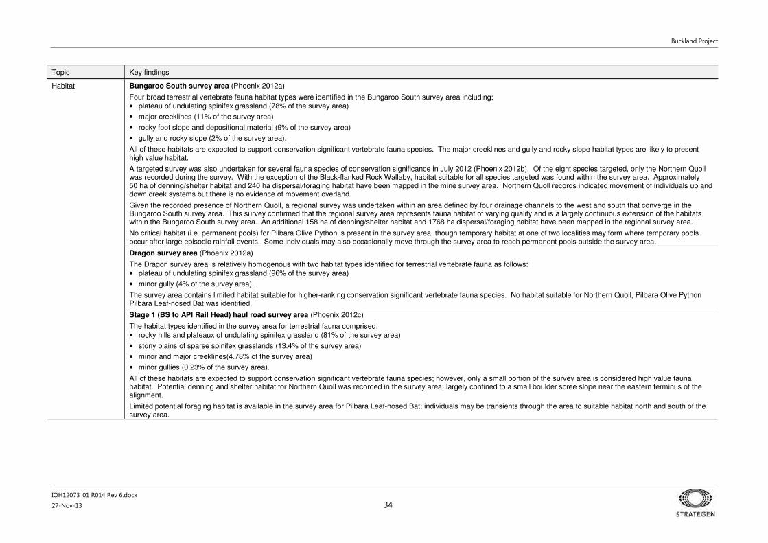
Buckland Project
IOH12073_01 R014 Rev 6.docx
27-Nov-13 34
Topic Key findings
Habitat Bungaroo South survey area (Phoenix 2012a)
Four broad terrestrial vertebrate fauna habitat types were identified in the Bungaroo South survey area including:
• plateau of undulating spinifex grassland (78% of the survey area)
• major creeklines (11% of the survey area)
• rocky foot slope and depositional material (9% of the survey area)
• gully and rocky slope (2% of the survey area).
All of these habitats are expected to support conservation significant vertebrate fauna species. The major creeklines and gully and rocky slope habitat types are likely to present high value habitat.
A targeted survey was also undertaken for several fauna species of conservation significance in July 2012 (Phoenix 2012b). Of the eight species targeted, only the Northern Quoll was recorded during the survey. With the exception of the Black-flanked Rock Wallaby, habitat suitable for all species targeted was found within the survey area. Approximately 50 ha of denning/shelter habitat and 240 ha dispersal/foraging habitat have been mapped in the mine survey area. Northern Quoll records indicated movement of individuals up and down creek systems but there is no evidence of movement overland.
Given the recorded presence of Northern Quoll, a regional survey was undertaken within an area defined by four drainage channels to the west and south that converge in the Bungaroo South survey area. This survey confirmed that the regional survey area represents fauna habitat of varying quality and is a largely continuous extension of the habitats within the Bungaroo South survey area. An additional 158 ha of denning/shelter habitat and 1768 ha dispersal/foraging habitat have been mapped in the regional survey area.
No critical habitat (i.e. permanent pools) for Pilbara Olive Python is present in the survey area, though temporary habitat at one of two localities may form where temporary pools occur after large episodic rainfall events. Some individuals may also occasionally move through the survey area to reach permanent pools outside the survey area.
Dragon survey area (Phoenix 2012a)
The Dragon survey area is relatively homogenous with two habitat types identified for terrestrial vertebrate fauna as follows:
• plateau of undulating spinifex grassland (96% of the survey area)
• minor gully (4% of the survey area).
The survey area contains limited habitat suitable for higher-ranking conservation significant vertebrate fauna species. No habitat suitable for Northern Quoll, Pilbara Olive Python Pilbara Leaf-nosed Bat was identified.
Stage 1 (BS to API Rail Head) haul road survey area (Phoenix 2012c)
The habitat types identified in the survey area for terrestrial fauna comprised:
• rocky hills and plateaux of undulating spinifex grassland (81% of the survey area)
• stony plains of sparse spinifex grasslands (13.4% of the survey area)
• minor and major creeklines(4.78% of the survey area)
• minor gullies (0.23% of the survey area).
All of these habitats are expected to support conservation significant vertebrate fauna species; however, only a small portion of the survey area is considered high value fauna habitat. Potential denning and shelter habitat for Northern Quoll was recorded in the survey area, largely confined to a small boulder scree slope near the eastern terminus of the alignment.
Limited potential foraging habitat is available in the survey area for Pilbara Leaf-nosed Bat; individuals may be transients through the area to suitable habitat north and south of the survey area.

Buckland Project
IOH12073_01 R014 Rev 6.docx
27-Nov-13 35
Topic Key findings
Stage 1 (API Rail Head to NWCH) Stage 2 haul road survey area (Phoenix 2013b)
The survey area contains the following fauna habitats:
• Rocky hills and plateaux – (60.3% of the survey area) mostly found in stage 1 corridor section of the survey area, contains several features (rocky outcrops providing stony habitat structure and shelter) that can potentially support several conservation species (especially mammals) such as the Northern Quoll (depending on the availability of caves, rock piles, etc.) Long-tailed Dunnart and Western Pebble Mound Mouse.
• Stony plain – (35.3% of the survey area) predominant across the stage 2 corridor section. Occasional areas of open woodland, shrubland and grassland are present (e.g. Buffel grass, Triodia sp., Acacia sp.). Sheet flow can occur in some areas especially below areas of poorly drained lower slopes. This habitat type can support conservation significant vertebrates such as Western Pebble-mound Mouse and Australian Bustard.
• Creekline – (3.4% of the survey area) found widely across the survey area. Minor and major creeklines are both present with the Robe River intersecting the stage 2 corridor section. The stage 1 corridor section is more dissected topographically and contains more creeklines. This habitat is may host several species of conservation significance, including Pilbara Leaf-nosed Bat, Pilbara Olive Python, Northern Quoll and Rainbow Bee-eater.
• Minor gully – (1.1% of the survey area) gullies represent only a very small portion of the survey area and are generally associated with the minor creeklines. They are exclusively present in the stage 1 corridor. There is potential Northern Quoll denning habitat in small patches at several locations.
Most of the survey area comprises widely represented fauna habitat of low to moderate value for vertebrate fauna. No particularly high values were observed in any of the four sections of the Stage 2 haul road survey area. The alignment generally avoids large topographical features and; therefore, does not directly intersect high value habitats that may support conservation significant vertebrate fauna. Potential foraging/dispersal habitat for Northern Quoll was identified at the Robe River crossing and this species may utilise the crossing from time to time. (Phoenix 2013b).
Surface water impacts on minesite creek habitat
Flood bunds will be constructed within the creek floodplains. Any encroachment of mining into the floodplain will restrict flow (in significant flood events) and cause water levels to rise. An estimation of flood levels was based on models of five Bungaroo Creek tributaries and associated floodplains using one-dimensional backwater modelling software (RPS 2013c).
The estimated existing (natural) water level profiles and flow velocities provided a base case against which subsequent simulations incorporating bunds could be compared. A 50 m width between the bunds and opposite creek bank was generally found to be suitable to allow flow to continue along the main Bungaroo Creek (past the East pit and the West pit) and a 30 m width was suitable at ‘Creek 5’ adjacent to the West pit (RPS 2013c). The bunds will be rock armoured against flood flows.
Flow velocities tend to be variable along the reaches and do not markedly increase as constriction on the waterway area is increased; however, flood depths steadily increases as constriction increases. Restriction of the channel increases flood height and therefore flood width commensurately. Several cross sections were investigated at the west and east pits. During a 100-year ARI flood, it would be expected that the restricted flood levels would increase up to one metre over natural flood levels (RPS 2013c).
Terrestrial fauna (short-range endemic invertebrates)
Conservation significant species
Bungaroo South survey area (Phoenix 2012a)
576 individual specimens from four SRE target groups were collected from the Bungaroo South survey area. No confirmed SREs were recorded.
Three taxa considered likely to be SREs and four potential SRE taxa were recovered (Appendix 1).
All likely and potential SRE taxa recorded have been identified outside of the survey area with the exception of the isopod Philosciidae 'pannawonica' although suitable habitat is well represented throughout the creek system. Species identification of three of the likely and potential taxa was not possible; as such, specimens recorded within the Bungaroo South survey area may not be the same species as specimens recorded outside the survey area.
Dragon survey area (Phoenix 2012a)
Given the paucity of suitable SRE habitat, no survey sites were established for the Dragon deposit area.
Stage 1 haul road survey area (Phoenix 2012c)
No SRE invertebrates were indentified from the survey area in the desktop review. 43 individual specimens were recorded from four SRE target groups during surveys. No confirmed or likely SREs were recorded from the survey area.
Four taxa considered to be potential SREs were recorded within the Stage 1 haul road alignment survey area (Appendix 1) Buddelundia '62' was the only specimen that is currently only known from the survey area.

Buckland Project
IOH12073_01 R014 Rev 6.docx
27-Nov-13 36
Topic Key findings
Stage 1 (API Rail Head to NWCH) and Stage 2 haul road survey area (Phoenix 2013b)
12 specimens from four target groups were collected from the survey area. A likely SRE species, Aname ‘MYG271-DNA’ was identified through the desktop review from within stony plain habitat (Appendix 1). While this species was not recorded during surveys, this habitat comprises 92% of the survey area.
Two specimens of an unidentified armadillid slater, Barrowdillo sp. Indet. associated with creekline habitat of the Robe River are considered to be a potential SRE (Appendix 1).
Habitat Five broad habitats were found across the Proposal area, three of which have the potential to support SREs, including:
• minor and major creeklines
• rocky foot slope and depositional material
• gully and rocky slopes.
Bungaroo South survey area (Phoenix 2012a)
Six sites were assessed in the Bungaroo South survey area representing the majority of available SRE habitats within the survey area. Nine sites were also selected within the broader regional survey area. The majority of SRE taxa were recovered from the habitat type ‘gullies and rocky slope’ (ten SREs) and rocky foot slopes (six SREs).
Two potential SREs were recorded in the habitat type ‘creekline’. This indicates that shelter and moist conditions may be a factor in the distribution of SREs; however, no major vegetation was found in the Bungaroo South survey area to support creekline SREs.
All likely and potential SRE taxa recorded from the Bungaroo South survey area have been identified outside of the survey area with the exception of the isopod Philosciidae 'pannawonica' (Appendix 1). This taxa was found in ‘rocky foot slope’ habitat that is well represented throughout the Bungaroo Creek system, outside of the Bungaroo South survey area.
Dragon survey area (Phoenix 2012a)
The Dragon survey area comprises a continuous, exposed landscape (of spinifex grassland plateau) and lacks suitable habitat for SRE invertebrates. This area was not surveyed for invertebrate SREs.
Stage 1 haul road survey area (Phoenix 2012c)
Four potential SRE sites were identified in the Stage 1 haul road survey area. Two main habitat types supporting SREs were identified in the survey area: ‘gully and rocky slope on minor creekline’ and ‘gully and rocky slope on rocky hills and plateaux’. All SRE habitats are well represented outside the survey area, including habitat for the taxa Buddelundia '62' that is currently only known from the survey area.
Stage 2 haul road survey area (Phoenix 2013)
Following an assessment of aerial photography and ground-truthing, three creekline habitats were considered suitable for SREs within the Stage 2 haul road survey area. The survey did not identify any major SRE habitat or geological features restricted to the survey area. All habitats present are well represented outside the survey area and are part of larger connected systems.
Subterranean fauna
Troglofauna – conservation significant species
Sample effort was just below the EPA guideline requirement: 59 samples from west pit; 58 samples from east pit; 37 samples from Dragon; 92 reference samples from across the survey area.
Sampling (Figure 34) yielded 280 troglofaunal animals representing 15 Orders and 40 species. The majority of species were collected from both impact and reference areas. 32 species are known only from the survey. 15 species are currently known only from within the proposed mine pits, of which 10 are singletons and one doubleton. The review indicates that species currently only known from the proposed mine pits are unlikely to be restricted to the pits. It is likely that the apparently localised ranges of these 15 species are artefacts of them occurring at low abundance. These species and their likely range are discussed in more detail in Section 4.3.5 and Bennelongia (2013).
Stygofauna - conservation significant species
Stygofauna sampling (Figure 35) recorded at least 28 species represented by 10 higher taxonomic levels. Eight of the stygofauna species collected are known to be widespread in the western Pilbara or beyond. Six species are known to occur widely in the Robe catchment. On the basis of existing data, 12 species are known only from within the survey area, including nine identified species and three taxa only identified to family or genus. The review indicates that species currently only known from the survey area are unlikely to be restricted to that area. These species and their likely range are discussed in Section 4.3.5 and Bennelongia (2013).
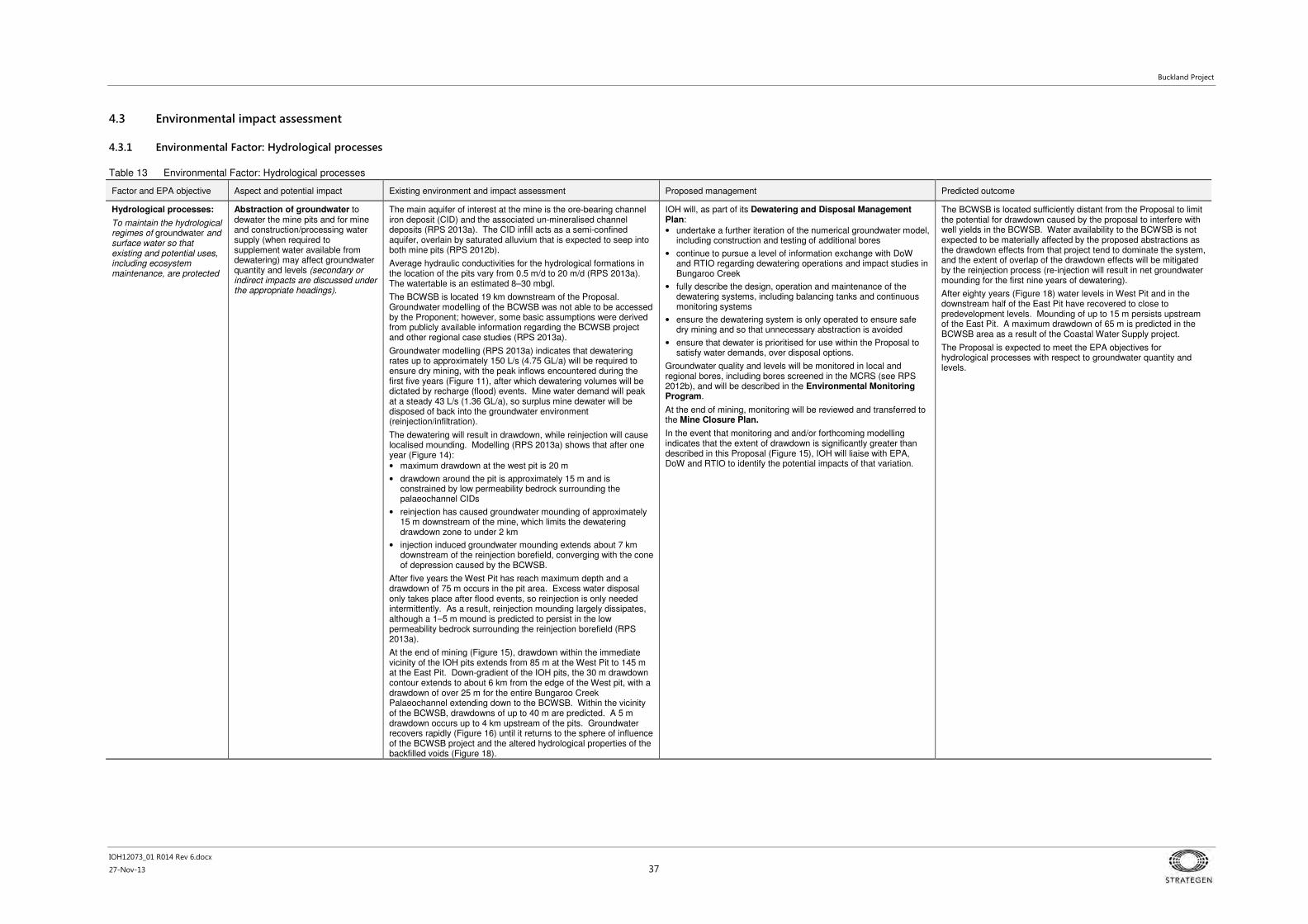
Buckland Project
IOH12073_01 R014 Rev 6.docx
27-Nov-13 37
4.3 Environmental impact assessment
4.3.1 Environmental Factor: Hydrological processes
Table 13 Environmental Factor: Hydrological processes
Factor and EPA objective Aspect and potential impact Existing environment and impact assessment Proposed management Predicted outcome
Hydrological processes:
To maintain the hydrological regimes of groundwater and surface water so that existing and potential uses, including ecosystem maintenance, are protected
Abstraction of groundwater to dewater the mine pits and for mine and construction/processing water supply (when required to supplement water available from dewatering) may affect groundwater quantity and levels (secondary or indirect impacts are discussed under the appropriate headings).
The main aquifer of interest at the mine is the ore-bearing channel iron deposit (CID) and the associated un-mineralised channel deposits (RPS 2013a). The CID infill acts as a semi-confined aquifer, overlain by saturated alluvium that is expected to seep into both mine pits (RPS 2012b).
Average hydraulic conductivities for the hydrological formations in the location of the pits vary from 0.5 m/d to 20 m/d (RPS 2013a). The watertable is an estimated 8–30 mbgl.
The BCWSB is located 19 km downstream of the Proposal. Groundwater modelling of the BCWSB was not able to be accessed by the Proponent; however, some basic assumptions were derived from publicly available information regarding the BCWSB project and other regional case studies (RPS 2013a).
Groundwater modelling (RPS 2013a) indicates that dewatering rates up to approximately 150 L/s (4.75 GL/a) will be required to ensure dry mining, with the peak inflows encountered during the first five years (Figure 11), after which dewatering volumes will be dictated by recharge (flood) events. Mine water demand will peak at a steady 43 L/s (1.36 GL/a), so surplus mine dewater will be disposed of back into the groundwater environment (reinjection/infiltration).
The dewatering will result in drawdown, while reinjection will cause localised mounding. Modelling (RPS 2013a) shows that after one year (Figure 14):
• maximum drawdown at the west pit is 20 m
• drawdown around the pit is approximately 15 m and is constrained by low permeability bedrock surrounding the palaeochannel CIDs
• reinjection has caused groundwater mounding of approximately 15 m downstream of the mine, which limits the dewatering drawdown zone to under 2 km
• injection induced groundwater mounding extends about 7 km downstream of the reinjection borefield, converging with the cone of depression caused by the BCWSB.
After five years the West Pit has reach maximum depth and a drawdown of 75 m occurs in the pit area. Excess water disposal only takes place after flood events, so reinjection is only needed intermittently. As a result, reinjection mounding largely dissipates, although a 1–5 m mound is predicted to persist in the low permeability bedrock surrounding the reinjection borefield (RPS 2013a).
At the end of mining (Figure 15), drawdown within the immediate vicinity of the IOH pits extends from 85 m at the West Pit to 145 m at the East Pit. Down-gradient of the IOH pits, the 30 m drawdown contour extends to about 6 km from the edge of the West pit, with a drawdown of over 25 m for the entire Bungaroo Creek Palaeochannel extending down to the BCWSB. Within the vicinity of the BCWSB, drawdowns of up to 40 m are predicted. A 5 m drawdown occurs up to 4 km upstream of the pits. Groundwater recovers rapidly (Figure 16) until it returns to the sphere of influence of the BCWSB project and the altered hydrological properties of the backfilled voids (Figure 18).
IOH will, as part of its Dewatering and Disposal Management Plan:
• undertake a further iteration of the numerical groundwater model, including construction and testing of additional bores
• continue to pursue a level of information exchange with DoW and RTIO regarding dewatering operations and impact studies in Bungaroo Creek
• fully describe the design, operation and maintenance of the dewatering systems, including balancing tanks and continuous monitoring systems
• ensure the dewatering system is only operated to ensure safe dry mining and so that unnecessary abstraction is avoided
• ensure that dewater is prioritised for use within the Proposal to satisfy water demands, over disposal options.
Groundwater quality and levels will be monitored in local and regional bores, including bores screened in the MCRS (see RPS 2012b), and will be described in the Environmental Monitoring Program.
At the end of mining, monitoring will be reviewed and transferred to the Mine Closure Plan.
In the event that monitoring and and/or forthcoming modelling indicates that the extent of drawdown is significantly greater than described in this Proposal (Figure 15), IOH will liaise with EPA, DoW and RTIO to identify the potential impacts of that variation.
The BCWSB is located sufficiently distant from the Proposal to limit the potential for drawdown caused by the proposal to interfere with well yields in the BCWSB. Water availability to the BCWSB is not expected to be materially affected by the proposed abstractions as the drawdown effects from that project tend to dominate the system, and the extent of overlap of the drawdown effects will be mitigated by the reinjection process (re-injection will result in net groundwater mounding for the first nine years of dewatering).
After eighty years (Figure 18) water levels in West Pit and in the downstream half of the East Pit have recovered to close to predevelopment levels. Mounding of up to 15 m persists upstream of the East Pit. A maximum drawdown of 65 m is predicted in the BCWSB area as a result of the Coastal Water Supply project.
The Proposal is expected to meet the EPA objectives for hydrological processes with respect to groundwater quantity and levels.

Buckland Project
IOH12073_01 R014 Rev 6.docx
27-Nov-13 38
Factor and EPA objective Aspect and potential impact Existing environment and impact assessment Proposed management Predicted outcome
Reinjection of surplus mine dewater may affect ecological systems in the area.
The closest permanent or semi-permanent water is Old Yalleen, 18 km downstream of the Proposal (DoW 2013). Creating a new water source may impact on indigenous fauna, such as expanding the range of feral animals.
The proposed reinjection area includes examples of Eucalyptus victrix, which is widespread throughout the northern half of Western Australian and is known to tolerate a wide range of water regimes. It typically occurs along inland drainage lines and floodplains and can survive occasional inundation and waterlogging, but could suffer in persistently wet conditions (Onshore 2013d).
IOH will, as part of its Dewatering and Disposal Management Plan:
• manage the reinjection/infiltration system so that groundwater mounding does not occur to the point of shallow water-logging or surface expression (groundwater level targets will be developed for the plan by a relevant consultant)
• identify and implement acceptable contingency measures if groundwater targets cannot be safeguarded or vegetation health declines as a result, including installation of additional bores, expansion of the infiltration system, or temporary disposal via controlled surface discharge at multiple locations (see Section 2.5.8).
Methods and options are available to ensure ecological systems are not affected by the reinjection. Additionally, there are no conservation significant assemblages or species restricted to the proposed reinjection area.
The Proposal is expected to meet the EPA objectives for hydrological processes with respect to groundwater reinjection.
Construction of bunds leaving a minimum 50 m wide floodplain may increase flood heights upstream.
The Bungaroo Creek system ,as it passes the western and eastern pits, consists of a central channel between 30 and 80 m wide, located in an alluvial floodplain of between 50 and 100 m wide (RPS 2012a). Most water is thought to flow down the valley as groundwater through the alluvium (IOH personnel at the proposed mine area recently observed a significant (approximately 100 mm in 24 hours) unseasonal rainfall event. The field observations indicated no localised flooding, minor streamflow or pooling of water in Bungaroo Creek, despite the event intensity and potential for high runoff volumes from the surrounding rocky catchment.
Over the 20-year life of mine, a substantial proportion of flows (up to 20-year ARI) will be retained by the channel, which would be deepened where necessary to ensure this. The bunds would be designed to overtop at 100-year ARI (plus freeboard) and stabilised.
The channel will be deepened and stabilised, and edges of the alluvial floodplain in the vicinity of the Proposal are near vertical (e.g. see figures in Onshore 2013a), so little change in flood height and extent is expected (Figure 19, from RPS 2013c).
The flow velocities at the shallower outer edges of the floodplain would be low and non-scouring (typically <1 m/s). During a 100-year ARI flood, the flood velocities might be expected to increase in the order of 40% and in a 2-year ARI flood, the flow velocities at the floodplain edge would be expected to increase in the order of 20% (RPS 2013c).
Consultation with DMP indicates a preference for proponents to not rely on permanent closure structures, being the bunds in this case. Inadequate material is available to fully backfill the mine voids beyond the commitment to fill to the pre-mining watertable. Complete removal (pushing over and contouring) of the mine bunds at the end of mining would see all creek flows below (an estimated) 20-year ARI flood level terminating at the partially backfilled mine voids. The applicable recurrence interval would decrease towards zero over time, as the remaining voids become filled with sediment as a result of natural flood scour.
IOH will continue with its detailed design of the bunds and creek channel modifications as a critical project element. The geotechnical studies of the floodplain and the identification of suitable construction material and stabilisation methods all form part of the detailed design phase.
At the end of mining, the bunds would be reformed to a lower and more stable profile, with spillways, so that base-flows continue to be directed away from the depressions left by the former pits, until peak events (e.g. floods > 10-year ARI) gradually fill the depressions with the mobile alluvium.
No significant alteration in flow regimes is expected to occur as a result of pit bunding.
The Proposal is expected to meet the EPA objectives for hydrological processes with respect to bunding for flood protection.
Haul road crossings on Robe and Fortescue Rivers may alter base flows and/or flood regimes.
The proposed low floodway design has been modelled for the Robe River crossing (Figure 20) and would increase 2-year ARI flood levels by 30 cm. There is no discernible difference in flood levels at intervals greater than this. A similar design would be used for the Fortescue River crossing (Stage 2).
In the development of detailed designs for the crossings, IOH will:
• minimise impacts to flows less than 1-year ARI by careful positioning of culverts
• select crossing points with as little vegetation as possible.
No significant alteration in flow regimes are expected to occur as a result of haul road river crossings.
The Proposal is expected to meet the EPA objectives for hydrological processes with respect to haul road crossings.

Buckland Project
IOH12073_01 R014 Rev 6.docx
27-Nov-13 39
4.3.2 Environmental Factor: Inland Waters Environmental Quality
Table 14 Environmental Factor: Inland Waters Environmental Quality
Factor and EPA objective Aspect and potential impact Existing environment and impact assessment Proposed management Predicted outcome
Inland Waters Environmental Quality:
To maintain the quality of groundwater and surface water, sediment and/or biota so that the environmental values, both ecological and social, are protected.
Disposal of surplus mine dewater to groundwater environment may affect groundwater quality.
Groundwater in the receiving environment is pH 6-8.6, with TDS 300–400 mg/L; alkalinity 80–100 mg/L (as CaCO3) (RPS 2012b).
Groundwater in the receiving environment naturally contains levels of aluminium (DoW 2012), iron and manganese (RPS 2012b) above Australian Drinking Water Guidelines.
Particle tracking (Figure 21, RPS 2013a) indicates any contaminant from the mine would take 70–80 years to reach the first BCWSB production bore; which is consistent with the 30 years predicted by RTIO for its future mining that is proposed between the IOH tenement and the BCWSB production bores (as reported in DOW 2012b). The risk to the BCWSB will be mitigated by the slow rates of groundwater movement, combined with dilution, diffusion and dispersion processes, which are expected to reduce any contaminant concentrations of concern to levels below any drinking water quality guideline values, such that the Proposal presents no risk to the quality of water available to the BCWSB.
IOH will, as part of its Dewatering and Disposal Management Plan:
• fully describe the design, operation and maintenance of the abstraction and reinjection systems, including balancing tanks and continuous monitoring systems
• define the types (sources), volumes and quality of water that can be discharged through the reinjection system
• set management objectives and performance criteria for the reinjection and contingency surface disposal systems, including water quality aspects.
No site stormwater or wastewater will be disposed through the reinjection system.
Groundwater quality and levels will be monitored in local and regional bores, including in the reinjection areas, and will be described in the Environmental Monitoring Program.
In the event that abstraction water quality begins to deteriorate below expected parameters, or impacts are detected at the reinjection/alternative disposal areas, DoW will be notified and appropriate responses investigated, including diversion and treatment options, and implemented to DoW satisfaction.
Only groundwater of acceptable quality would be disposed through the reinjection system, which would be tracked by continuous monitoring. Any residual risk to the BCWSB will be mitigated by the slow rates of groundwater movement, combined with dilution, diffusion and dispersion processes, which are expected to reduce any contaminant concentrations of concern to levels below any drinking water quality guideline values, such that the Proposal presents no risk to the quality of water available to the BCWSB.
The dewatering and reinjection transfer system will be designed and constructed to avoid oxygenating the groundwater (see Section 2.5.8).
Proven treatment options exist for most metalloid contaminants, noting that aluminium, iron and manganese have already been recorded at levels above those considered suitable for drinking water.
The Proposal is expected to meet the EPA objectives for Inland Waters Environmental Quality with respect to the disposal of surplus mine dewater.

Buckland Project
IOH12073_01 R014 Rev 6.docx
27-Nov-13 40
Factor and EPA objective Aspect and potential impact Existing environment and impact assessment Proposed management Predicted outcome
Stormwater runoff and seepage from waste rock dumps and fines storage facility may affect surface and groundwater quality.
Note: the Proposal purposefully does not include the disposal of putrescible wastes or oily wastes within the Bungaroo Creek catchment.
Median total sulfur across all Bungaroo South below-watertable waste rock drill samples (2622) is 0.01%; 99.6% of samples have total sulfur less than 0.1% (IOH 2013).
High sulfur values are associated with black shale samples from below the base of mining, which would not be disturbed (unless exposed in side-wall or toe).
Waste rock and ore material tested exceeded WA DEC ISQG low or high trigger values for soils and sediments for arsenic (As), chromium (Cr), copper (Cu), mercury (Hg), nickel (Ni), antimony (Sb) and zinc (Zn). These metals are commonly found enriched in the vicinity of iron ore deposits in the Pilbara (URS 2013).
Waste fine samples did not exceed WA DEC ISQG low or high trigger values for soils and sediments for all metals, except antimony, which was reported to be marginally above the ISQG low trigger value. Waste fines had concentrations below the ANZECC/ARMCANZ trigger values for all metals and metalloids except Al and Zn (URS 2013).
Leachates from waste fines and waste rock samples are consistent with background water quality and/or drinking water guidelines, as do multiple supernatant test samples (URS 2013). There is no clear relationship between metal enrichment in the waste materials and leachate quality.
Particle tracking (Figure 21, RPS 2013a) indicates any contaminant from the mine would take 70-80 years to reach the first BCWSB production bore; which is consistent with the 30 years predicted by RTIO for its future mining that is proposed between the IOH tenement and the BCWSB production bores (as reported in DOW 2012b). The risk to the BCWSB will be mitigated by the slow rates of groundwater movement, combined with dilution, diffusion and dispersion processes, which are expected to reduce any contaminant concentrations of concern to levels below any drinking water quality guideline values, such that the Proposal presents no risk to the quality of water available to the BCWSB.
The WRD and WFSF will be built out of the floodplain on weathered BIF (Dales Gorge), 50-60 m above the water table (RPS 2012b, 2013d). The topography and low permeability of the underlying landform is expected to direct any seepage and/or leachate towards central collection points. It has been estimated that 90% of rainfall to the WRD would be lost as runoff or evaporation, with 15 ML/yr collected as lateral seepage and 35 ML/yr infiltrating downwards (RPS 2013d). Approximately 150 ML/yr will be infiltrated from the WFSF, with a large proportion presumed to be collected by interception (TetraTech 2013).
All waste landforms will be backfilled into the Bungaroo Creek mine pits so that void lakes are avoided.
IOH will, as part of its AMD Management Plan: 1. For black shales:
* complete kinetic tests of black shale samples to confirm acid generating potential, within first two years of mining
* develop approaches and procedures for characterising and avoiding black shales within the mine pit; and responses if such material is uncovered such as special containment using internal clays and other low-porosity materials.
2. For waste rock:
* divert stormwater around the dump site, where possible
* collect stormwater from the WRD catchment for monitoring
* maintain a minimum 50 m separation distance between dumps and the edge of Bungaroo Creek
* construct basement toes and batters out of non-acid forming (NAF) material; batters will be also be erosion-resistant
* undertake kinetic tests of waste rock to quantify the acid neutralising capacity of the backfill and in situ CID, within the first two years of mining.
3. For waste fines:
* a WFSF Design and Operating Plan will be developed, in accordance with DMP requirements and ANCOLD specifications
* the WFSF will be designed not to overtop, with interception systems below the dam walls to collect seepage from the wall and shallow groundwater
* stormwater (other than incidental) will be prevented from entering the WFSF
* waste fines and return water from the WFSF will be routinely monitored and the water treatment process revised if water quality issues are detected.
Groundwater quality and levels will be monitored in local and regional bores, including bores around the WRD and WFSF, and will be described in the Environmental Monitoring Program.
The Mine Closure Plan will describe how all above ground waste materials will be returned to the Bungaroo pits for backfill and the areas stabilised and rehabilitated.
Overall AMD risk at the site is very low, with 99.6% of waste rock samples having sulfur values below the conservative trigger of 0.1% total sulfur. Leachate from waste rock and waste fines samples satisfied either background or drinking water quality and in most cases, both.
IOH considers the risk of encountering black shale is low and any encounters can be managed using standard measures in practice at other mine sites.
The WFSF will exceed engineering guidelines and will be removed as backfill for the Bungaroo pits, along with any waste rock material from the pits.
The commitment to extensive and detailed geochemical investigations and ongoing monitoring of waste materials will ensure that, by the time direct backfill operations have commenced from the East pit, the level of confidence in predictions regarding AMD and groundwater quality will be substantial.
A comprehensive ground and surface water monitoring program will be developed and implemented to the satisfaction of DoW.
The Proposal is expected to meet the EPA objectives for Inland Waters Environmental Quality with respect to runoff and seepage from non-mineralised waste facilities.
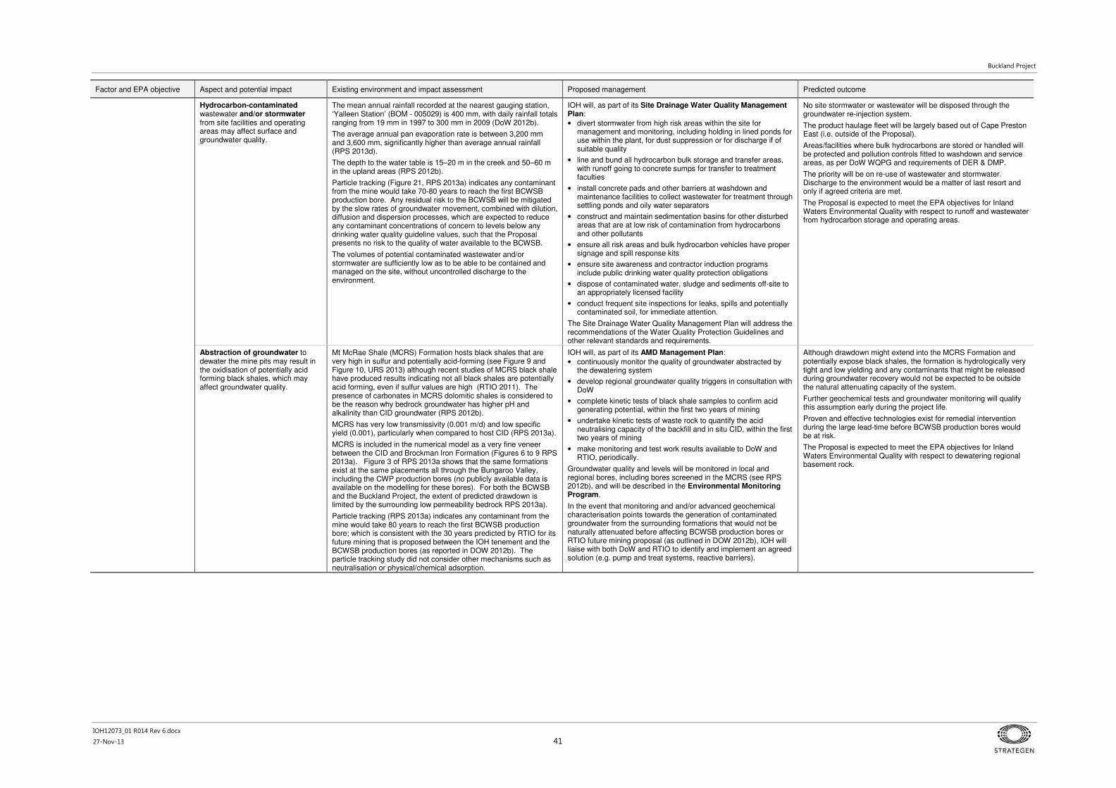
Buckland Project
IOH12073_01 R014 Rev 6.docx
27-Nov-13 41
Factor and EPA objective Aspect and potential impact Existing environment and impact assessment Proposed management Predicted outcome
Hydrocarbon-contaminated wastewater and/or stormwater from site facilities and operating areas may affect surface and groundwater quality.
The mean annual rainfall recorded at the nearest gauging station, ‘Yalleen Station’ (BOM - 005029) is 400 mm, with daily rainfall totals ranging from 19 mm in 1997 to 300 mm in 2009 (DoW 2012b).
The average annual pan evaporation rate is between 3,200 mm and 3,600 mm, significantly higher than average annual rainfall (RPS 2013d).
The depth to the water table is 15–20 m in the creek and 50–60 m in the upland areas (RPS 2012b).
Particle tracking (Figure 21, RPS 2013a) indicates any contaminant from the mine would take 70-80 years to reach the first BCWSB production bore. Any residual risk to the BCWSB will be mitigated by the slow rates of groundwater movement, combined with dilution, diffusion and dispersion processes, which are expected to reduce any contaminant concentrations of concern to levels below any drinking water quality guideline values, such that the Proposal presents no risk to the quality of water available to the BCWSB.
The volumes of potential contaminated wastewater and/or stormwater are sufficiently low as to be able to be contained and managed on the site, without uncontrolled discharge to the environment.
IOH will, as part of its Site Drainage Water Quality Management Plan:
• divert stormwater from high risk areas within the site for management and monitoring, including holding in lined ponds for use within the plant, for dust suppression or for discharge if of suitable quality
• line and bund all hydrocarbon bulk storage and transfer areas, with runoff going to concrete sumps for transfer to treatment faculties
• install concrete pads and other barriers at washdown and maintenance facilities to collect wastewater for treatment through settling ponds and oily water separators
• construct and maintain sedimentation basins for other disturbed areas that are at low risk of contamination from hydrocarbons and other pollutants
• ensure all risk areas and bulk hydrocarbon vehicles have proper signage and spill response kits
• ensure site awareness and contractor induction programs include public drinking water quality protection obligations
• dispose of contaminated water, sludge and sediments off-site to an appropriately licensed facility
• conduct frequent site inspections for leaks, spills and potentially contaminated soil, for immediate attention.
The Site Drainage Water Quality Management Plan will address the recommendations of the Water Quality Protection Guidelines and other relevant standards and requirements.
No site stormwater or wastewater will be disposed through the groundwater re-injection system.
The product haulage fleet will be largely based out of Cape Preston East (i.e. outside of the Proposal).
Areas/facilities where bulk hydrocarbons are stored or handled will be protected and pollution controls fitted to washdown and service areas, as per DoW WQPG and requirements of DER & DMP.
The priority will be on re-use of wastewater and stormwater. Discharge to the environment would be a matter of last resort and only if agreed criteria are met.
The Proposal is expected to meet the EPA objectives for Inland Waters Environmental Quality with respect to runoff and wastewater from hydrocarbon storage and operating areas.
Abstraction of groundwater to dewater the mine pits may result in the oxidisation of potentially acid forming black shales, which may affect groundwater quality.
Mt McRae Shale (MCRS) Formation hosts black shales that are very high in sulfur and potentially acid-forming (see Figure 9 and Figure 10, URS 2013) although recent studies of MCRS black shale have produced results indicating not all black shales are potentially acid forming, even if sulfur values are high (RTIO 2011). The presence of carbonates in MCRS dolomitic shales is considered to be the reason why bedrock groundwater has higher pH and alkalinity than CID groundwater (RPS 2012b).
MCRS has very low transmissivity (0.001 m/d) and low specific yield (0.001), particularly when compared to host CID (RPS 2013a).
MCRS is included in the numerical model as a very fine veneer between the CID and Brockman Iron Formation (Figures 6 to 9 RPS 2013a). Figure 3 of RPS 2013a shows that the same formations exist at the same placements all through the Bungaroo Valley, including the CWP production bores (no publicly available data is available on the modelling for these bores). For both the BCWSB and the Buckland Project, the extent of predicted drawdown is limited by the surrounding low permeability bedrock RPS 2013a).
Particle tracking (RPS 2013a) indicates any contaminant from the mine would take 80 years to reach the first BCWSB production bore; which is consistent with the 30 years predicted by RTIO for its future mining that is proposed between the IOH tenement and the BCWSB production bores (as reported in DOW 2012b). The particle tracking study did not consider other mechanisms such as neutralisation or physical/chemical adsorption.
IOH will, as part of its AMD Management Plan:
• continuously monitor the quality of groundwater abstracted by the dewatering system
• develop regional groundwater quality triggers in consultation with DoW
• complete kinetic tests of black shale samples to confirm acid generating potential, within the first two years of mining
• undertake kinetic tests of waste rock to quantify the acid neutralising capacity of the backfill and in situ CID, within the first two years of mining
• make monitoring and test work results available to DoW and RTIO, periodically.
Groundwater quality and levels will be monitored in local and regional bores, including bores screened in the MCRS (see RPS 2012b), and will be described in the Environmental Monitoring Program.
In the event that monitoring and and/or advanced geochemical characterisation points towards the generation of contaminated groundwater from the surrounding formations that would not be naturally attenuated before affecting BCWSB production bores or RTIO future mining proposal (as outlined in DOW 2012b), IOH will liaise with both DoW and RTIO to identify and implement an agreed solution (e.g. pump and treat systems, reactive barriers).
Although drawdown might extend into the MCRS Formation and potentially expose black shales, the formation is hydrologically very tight and low yielding and any contaminants that might be released during groundwater recovery would not be expected to be outside the natural attenuating capacity of the system.
Further geochemical tests and groundwater monitoring will qualify this assumption early during the project life.
Proven and effective technologies exist for remedial intervention during the large lead-time before BCWSB production bores would be at risk.
The Proposal is expected to meet the EPA objectives for Inland Waters Environmental Quality with respect to dewatering regional basement rock.

Buckland Project
IOH12073_01 R014 Rev 6.docx
27-Nov-13 42
4.3.3 Environmental Factor: Flora and vegetation
Table 15 Environmental Factor: Flora and vegetation
Factor and EPA objective Aspect and potential impact Existing environment and impact assessment Proposed management Predicted outcome
Flora and Vegetation:
To maintain representation, diversity, viability and ecological function at the species, population and community level.
Clearing for mine and haul road development may affect representation and diversity at the species population and community level.
The Proposal is located within the Fortescue Botanical District (Pilbara Region) of the Eremaean Province (Beard 1990). The mine component of the Proposal intersects two pre-European vegetation sub-associations and the proposed haul road corridor intersects an additional 15 pre-European vegetation sub-associations (Figure 24). All of the impacted sub-associations have 100% of their pre-European extent remaining. Clearing as a result of the Proposal is unlikely to affect more than 3% of the mapped extent of any of the regional vegetation sub-associations (Appendix 1).
Nine vegetation units from seven broad floristic formations were described within the mine area (Figure 23). Twenty-seven vegetation units from eleven broad floristic formations were described in the Bungaroo South to API Rail Head (Stage 1) survey area (Onshore 2013b). Twenty four vegetation units from eleven broad floristic formations were described in the API Rail Head to NWCH survey (Onshore 2013e). None of the units were considered to be rare or restricted or matched with the descriptions of TECs or PECs, and none supported DRF (see Appendix 1 for further details on this screening).
The extent of disturbance resulting from the mine part of the Proposal has been calculated for each mapped vegetation unit (Appendix 1). Retention of more than 30% of the mapped extent of all but one of the nine units will occur (Figure 23). Vegetation unit 7b will have 80% of its mapped extent (156 ha) cleared; however, this unit (D. Brearley [Onshore] pers. comm. [N. Dixon, Ennovate] 1 July 2013):
• is very closely affiliated with the wider distributed unit 7a (685 ha mapped, 52% to be disturbed), the difference being the presence or absence of the tall shrub stratum of Acacia inaequilatera
• along with unit 7a, supports the Priority flora Triodia sp. Robe River but neither association is considered to represent the PEC "Triodia sp. Robe River assemblages of mesas of the West Pilbara (Priority 3)
• 7a and 7b in combination equate directly to unit 10a in the Stage 1 haul road survey (also supports Triodia sp. Robe River) but is different to the two units containing Triodia sp Robe River (P3) in the Stage 2 haul road
• along with unit 7a (mine) and 10a (Stage 1 haul road), is widely distributed on hill crests and slopes in the Hamersley Range, occurring as a mosaic and often interchangeable at a scale that cannot be accurately mapped
• along with unit 7a, is not determined to be restricted locally or regionally.
Calculations of impact on haul road vegetation units will be undertaken on completion of the final design, which will incorporate vegetation conservation priorities in its selection.
Six species of Priority flora were identified during all three studies (Table 12). No other locally or regionally conservation significant flora was identified.
Given the wide distribution of Priority flora found within the Proposal area, the relatively small scale of the mine and the linear nature of the haul road, any effects on these species as a result of vegetation clearing will be minimal (Appendix 1).
IOH will, as part of its Construction Environmental Management Plans for the mine and the haul road:
• clearing will be managed through internal ground disturbance procedures
• boundaries of areas to be cleared or disturbed will be identified by GPS coordinates and maps of boundaries will be provided to dozer operators
• undertake clearing progressively
• conduct raised blade disturbance where practicable on tracks to minimise vegetation removal
• design Proposal layout to ensure no clearing, ground disturbance or unauthorised access occurs within 10 m of any Threatened, P1 or P2 flora unless authorised under approval
• mulch cleared vegetation where possible, excluding some logs and branches that will be reused in rehabilitation works for provision of habitat and prevention of erosion
• incorporate surface water management and erosion protection into mine planning and design to minimise disruption to watercourses and riparian vegetation
• implement measures to manage surface water flows around the mine site area to minimise downstream effects
• implement weed hygiene and management measures to prevent spread of weeds and the introduction of new weed species as a result of construction and operation of the mine and infrastructure
• clean vehicles prior to entering vegetated areas to prevent introduction of weeds
• rehabilitate areas along the haul road disturbed during construction that are no longer required, using an agreed prescription developed for the landform and location.
IOH will ensure that all staff, contractors and visitors are made aware of obligations and objectives regarding the protection of native vegetation.
The Mine Closure Plan will describe how all disturbed areas within the minesite will be stabilised, treated and rehabilitated. The Plan will also include closure objectives and performance criteria, as well as a schedule for implementation, monitoring and maintenance, leading to suitable relinquishment of the tenement.
After application of management and mitigation measures, the Proposal is expected to result in the following outcomes in relation to vegetation and flora:
• clearing of up to 2050 ha of native vegetation.
• the loss of individual Priority flora is not expected to alter the conservation status or viability of these species
• significant residual impacts on vegetation and flora from this Proposal will be addressed in accordance with EPA requirements, as discussed in Section 7.
The Proposal, including offset measures, is expected to meet the EPA objectives for flora and vegetation with respect to clearing.
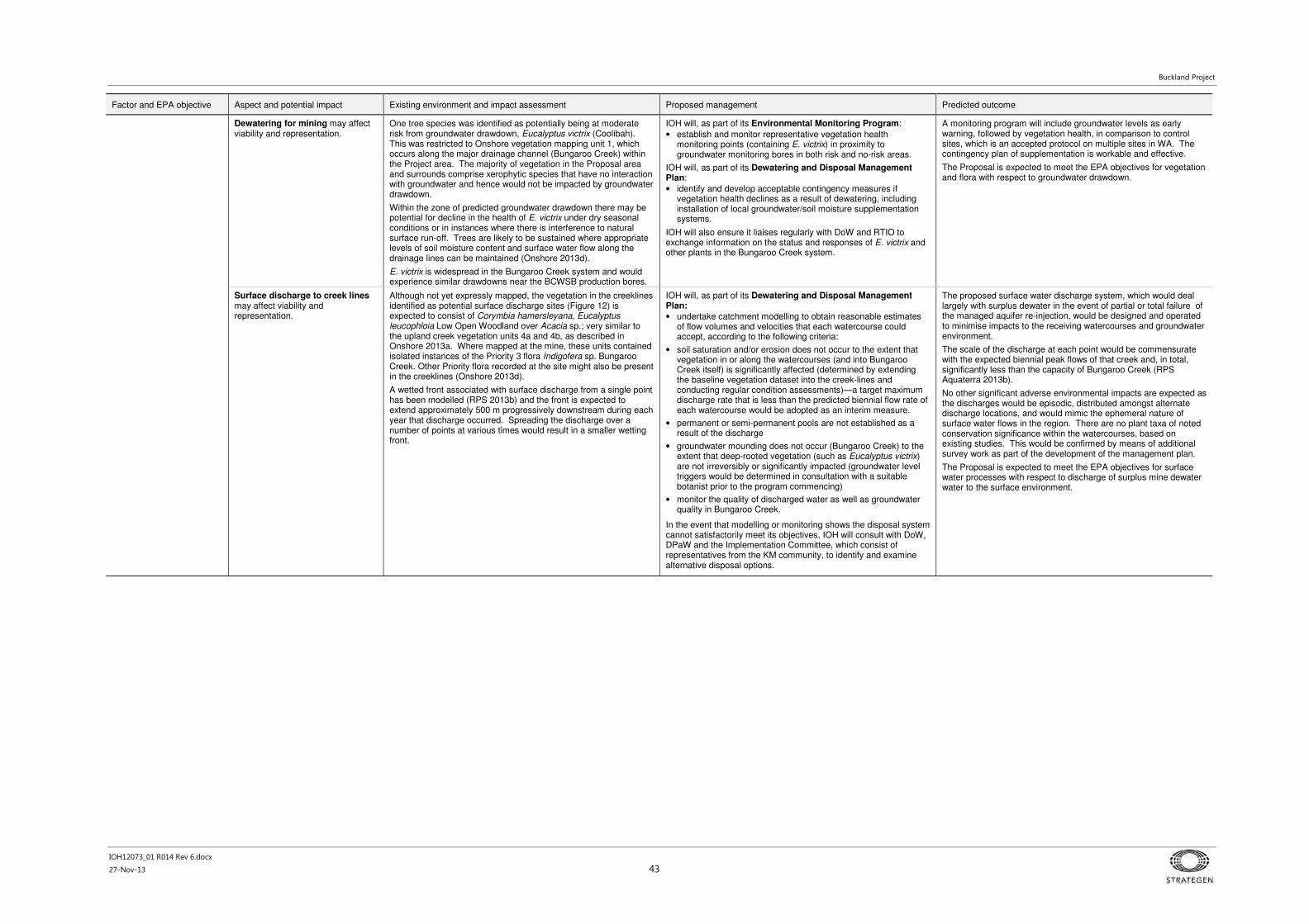
Buckland Project
IOH12073_01 R014 Rev 6.docx
27-Nov-13 43
Factor and EPA objective Aspect and potential impact Existing environment and impact assessment Proposed management Predicted outcome
Dewatering for mining may affect viability and representation.
One tree species was identified as potentially being at moderate risk from groundwater drawdown, Eucalyptus victrix (Coolibah). This was restricted to Onshore vegetation mapping unit 1, which occurs along the major drainage channel (Bungaroo Creek) within the Project area. The majority of vegetation in the Proposal area and surrounds comprise xerophytic species that have no interaction with groundwater and hence would not be impacted by groundwater drawdown.
Within the zone of predicted groundwater drawdown there may be potential for decline in the health of E. victrix under dry seasonal conditions or in instances where there is interference to natural surface run-off. Trees are likely to be sustained where appropriate levels of soil moisture content and surface water flow along the drainage lines can be maintained (Onshore 2013d).
E. victrix is widespread in the Bungaroo Creek system and would experience similar drawdowns near the BCWSB production bores.
IOH will, as part of its Environmental Monitoring Program:
• establish and monitor representative vegetation health monitoring points (containing E. victrix) in proximity to groundwater monitoring bores in both risk and no-risk areas.
IOH will, as part of its Dewatering and Disposal Management Plan:
• identify and develop acceptable contingency measures if vegetation health declines as a result of dewatering, including installation of local groundwater/soil moisture supplementation systems.
IOH will also ensure it liaises regularly with DoW and RTIO to exchange information on the status and responses of E. victrix and other plants in the Bungaroo Creek system.
A monitoring program will include groundwater levels as early warning, followed by vegetation health, in comparison to control sites, which is an accepted protocol on multiple sites in WA. The contingency plan of supplementation is workable and effective.
The Proposal is expected to meet the EPA objectives for vegetation and flora with respect to groundwater drawdown.
Surface discharge to creek lines may affect viability and representation.
Although not yet expressly mapped, the vegetation in the creeklines identified as potential surface discharge sites (Figure 12) is expected to consist of Corymbia hamersleyana, Eucalyptus leucophloia Low Open Woodland over Acacia sp.; very similar to the upland creek vegetation units 4a and 4b, as described in Onshore 2013a. Where mapped at the mine, these units contained isolated instances of the Priority 3 flora Indigofera sp. Bungaroo Creek. Other Priority flora recorded at the site might also be present in the creeklines (Onshore 2013d).
A wetted front associated with surface discharge from a single point has been modelled (RPS 2013b) and the front is expected to extend approximately 500 m progressively downstream during each year that discharge occurred. Spreading the discharge over a number of points at various times would result in a smaller wetting front.
IOH will, as part of its Dewatering and Disposal Management Plan:
• undertake catchment modelling to obtain reasonable estimates of flow volumes and velocities that each watercourse could accept, according to the following criteria:
• soil saturation and/or erosion does not occur to the extent that vegetation in or along the watercourses (and into Bungaroo Creek itself) is significantly affected (determined by extending the baseline vegetation dataset into the creek-lines and conducting regular condition assessments)—a target maximum discharge rate that is less than the predicted biennial flow rate of each watercourse would be adopted as an interim measure.
• permanent or semi-permanent pools are not established as a result of the discharge
• groundwater mounding does not occur (Bungaroo Creek) to the extent that deep-rooted vegetation (such as Eucalyptus victrix) are not irreversibly or significantly impacted (groundwater level triggers would be determined in consultation with a suitable botanist prior to the program commencing)
• monitor the quality of discharged water as well as groundwater quality in Bungaroo Creek.
In the event that modelling or monitoring shows the disposal system cannot satisfactorily meet its objectives, IOH will consult with DoW, DPaW and the Implementation Committee, which consist of representatives from the KM community, to identify and examine alternative disposal options.
The proposed surface water discharge system, which would deal largely with surplus dewater in the event of partial or total failure of the managed aquifer re-injection, would be designed and operated to minimise impacts to the receiving watercourses and groundwater environment.
The scale of the discharge at each point would be commensurate with the expected biennial peak flows of that creek and, in total, significantly less than the capacity of Bungaroo Creek (RPS Aquaterra 2013b).
No other significant adverse environmental impacts are expected as the discharges would be episodic, distributed amongst alternate discharge locations, and would mimic the ephemeral nature of surface water flows in the region. There are no plant taxa of noted conservation significance within the watercourses, based on existing studies. This would be confirmed by means of additional survey work as part of the development of the management plan.
The Proposal is expected to meet the EPA objectives for surface water processes with respect to discharge of surplus mine dewater water to the surface environment.

Buckland Project
IOH12073_01 R014 Rev 6.docx
27-Nov-13 44
4.3.4 Environmental Factor: Terrestrial fauna
Table 16 Environmental Factor: Terrestrial fauna
Factor and EPA objective Aspect and potential impact Existing environment and impact assessment Proposed management Predicted outcome
Terrestrial fauna:
To maintain representation, diversity, viability and ecological function at the species, population and assemblage level.
Vegetation clearing may result in loss of habitat, direct loss of species and reduced breeding and foraging habitat.
Vegetation clearing for the Proposal will result in the loss of habitat utilised by fauna. The fauna habitats within the Proposal area support a range of fauna species. Several conservation-significant fauna species have the potential to occur in the Proposal area (Figure 27 to Figure 29).
The following conservation significant species were recorded during surveys (Phoenix 2012a, 2012b, 2013, shown in Figure 27, Figure 28 and Figure 29, respectively): • Northern Quoll
• Pilbara leaf nosed bat
• Rainbow Bee-eater
• Western Pebble-mound Mouse
• Australian Bustard.
Targeted studies confirm the presence and some-times wide-ranging movement of Northern Quoll along the creeklines and along the base of the cliffs (Phoenix 2012b). Creeklines provide high quality habitat for a range of conservation significant fauna (Phoenix 2012a, 2013).
All areas surveyed with the exception of the Dragon survey area contain habitat suitable for SREs (Phoenix 2012a, 2013). The key habitats associated with SREs include:
• minor and major creeklines
• rocky foot slope and depositional material
• gully and rocky slopes.
The fauna habitats present in the Proposal area are similar to those in adjacent areas. The fauna assemblages in these habitats are also likely to be similar to that found in adjacent areas. The effect of the habitat loss from clearing will be localised when placed in a bioregional context (Phoenix 2012a, 2013).
Habitat in the Proposal area generally varies from low to high quality. Creeklines provide high quality habitat for a range of conservation significant fauna (Phoenix 2012a, 2012c, 2013). Northern Quoll habitat mapping as well as broader habitat mapping has been undertaken (Figure 30 to Figure 33).
The majority of SRE taxa were recovered from the habitat type ‘gullies and rocky slope’ and rocky foot slopes. Creekline habitats were also found to support potential SREs (Phoenix 2012a, 2012c, 2013). The Proponent is committed to avoiding the locality where the SRE taxa Buddelundia '62' was recorded. If the area cannot be avoided, further work will be undertaken in an attempt to identify if its distribution extends outside the Proposal area. Philosciidae 'pannawonica', Buddelundia sp. ind. Karaops sp. ind. and Cryptops sp. indet were not identified within the mine disturbance footprint (Figure 27).
The fauna habitats present in the Proposal area are similar to those in adjacent areas. The fauna assemblages in these habitats are also likely to be similar to that found in adjacent areas. The effect of the habitat loss from clearing will be localised when placed in a bioregional context (Phoenix 2012a, 2012c, 2013).
The key potential impact of the Proposal on terrestrial fauna (e.g. loss of habitat due to clearing) will generally be minimised via management measures aimed at reducing potential impacts on flora and vegetation, as detailed under Flora and Vegetation above.
The Proposal design has, and will continue to, avoid and minimise clearing of higher value fauna habitat where practicable.
The proposed mine pit boundaries and locations of associated infrastructure were developed to optimise resource recovery and operational costs while being sympathetic to the need to avoid or limit the impact to potential significant fauna values due to clearing and disturbance of habitat.
Mining activities will be sequenced and progressive backfilling and rehabilitation will be undertaken to minimise impacts to fauna that utilise Bungaroo Creek and maximise the amount of creek habitat available to fauna throughout the life of the Proposal.
The Proponent commits to retaining at least 30% of each mapped habitat type, which may mean avoiding some habitats.
The following key management measures will be implemented to manage potential impacts on fauna (and have been implemented during Proposal design to date where applicable): • staging of development to maximise available fauna habitat
• maintaining habitat connectivity within the Bungaroo Creek system
• conducting targeted fauna and vegetation surveys along the haul road corridor prior to disturbance
• co-locating haul roads with other linear infrastructure corridors where possible (e.g. DBNGP and GGP)
• retaining 50 m minimum buffer along creek embankments (unless approved)
• retaining 50 m waste dump buffer along cliff tops for movement of fauna during wet periods
• fauna egress mechanisms at all turkey nest dams
• avoiding rocky outcrops and large trees for fauna habitat unless they materially interfere with the ability to safely conduct project activities where possible
• limiting clearing to one front to enable native fauna to escape
• identifying areas of significant habitat to be avoided
• progressive mine pit backfilling and rehabilitation to reinstate with the aim of maximising the area available for fauna
• internal reporting of all incidents involving fauna death.
Given the extent of suitable habitat for Northern Quoll within the minesite area, a specific (draft) Northern Quoll Management Plan has also been prepared (Appendix 6). The basis for this is set out in the section immediately following this table (Threatened Fauna (Northern Quoll) Management Strategy). Additional specific design and management controls include:
• clearing campaigns and significant developments within Northern Quoll critical denning / shelter habitat will be scheduled to avoid the breeding season where possible
• constructing alternative habitat corridors to maintain connectivity
• conducting a program to monitor the effects of the Proposal on Northern Quoll.
In the event that monitoring suggests significant adverse effects on local Northern Quoll populations as a result of the Proposed Action, a framework will be developed for further investigations, management and contingency actions.
The proposed mine pit boundaries and locations of associated infrastructure were developed to optimise resource recovery and operational costs and balance the need to avoid or limit the impact to potential significant fauna values. As a result conservation significant SRE habitats have been avoided and a 50 m creek corridor and a 50 m buffer along the top of the creek have been retained. No other restricted habitats have been identified that are at risk of significant disturbance.
An innovative and leading monitoring program has been developed and will be implemented to track changes in utilisation (presence/absence and general activity/behaviour) of Northern Quoll through the corridors and around the creek system generally, with adaptive response measures identified (refer to the Threatened Fauna (Northern Quoll) Management Strategy).
Other active management measures are also consistent with best practice and stewardship principles.
After application of the described management and mitigation measures, the Proposal is expected to result in the following outcomes in relation to vertebrate fauna:
• approximately 2050 ha of potential fauna habitat will be disturbed
• conservation significant fauna are not expected to be significantly affected
• fauna habitats present in the Proposal area are similar to those in adjacent areas - the effect of the clearing will generally be localised when placed in a bioregional context
• minimal additional encroachment into Northern Quoll habitat during flood events as a result of bunding (see below)
• all SRE habitats are well represented outside of the survey area and impacts on SREs are expected to be restricted to a local scale
• the potential for indirect effects resulting from the Proposal are expected to be insignificant and can be addressed through the implementation of appropriate engineering design and management actions.
The Proposal is expected to meet the EPA objectives for terrestrial fauna with respect to clearing causing loss of habitat or species.

Buckland Project
IOH12073_01 R014 Rev 6.docx
27-Nov-13 45
Factor and EPA objective Aspect and potential impact Existing environment and impact assessment Proposed management Predicted outcome
Vegetation clearing may result in fragmentation of habitat, including reduction in regional linkages and interruption of population movement patterns for conservation significant fauna.
Clearing also has the potential to result in fragmentation of habitats.
Potential habitat for significant fauna occurs along the proposed haul road corridor, particularly along creeklines and in an area where Northern Quoll has been recorded previously (Phoenix 2013a).
Potential habitat for significant fauna occurs along the proposed haul road corridor, particularly along creeklines and in an area where Northern Quoll has been recorded previously (Phoenix 2013b, Figure 29).
Linear structures such as haul roads may potentially:
• partition existing activity areas and home ranges
• isolate sections of established communities
• alter long and medium-term patterns of movement around established home ranges particularly for small mammals and reptiles.
The Proponent has identified opportunities to create alternative habitat at the following two locations along the Bungaroo Creek system to maintain connectivity with adjacent areas (Figure 2):
• a 250 m portion on the north bank opposite the Bungaroo South east pit
• extension of an east-trending gully located 200 m south of the convergence of branches 3 and 4 of the Bungaroo creek system to connect these branches around the Bungaroo South east pit.
These areas will be developed and rehabilitated prior to commencement of any activities on the southern bank and Bungaroo South east pit to maintain habitat connectivity along the creek.
Where possible, the Proponent will avoid or minimise disturbance to critical habitat for Northern Quoll and other significant species. Where this objective cannot be fulfilled, the Proponent will ensure that road design includes features that reduce its impact to fauna, such as a raised profile that incorporates fauna underpasses and suitable culverts.
After application of the described management and mitigation measures, the Proposal is expected to result in maintenance and enhancement of habitat connectivity through Project design, staging of development, the creation of new areas of habitat and progressive rehabilitation.
The Proposal is expected to meet the EPA objectives for terrestrial fauna with respect to clearing effects on habitat fragmentation and regional linkages.
Bunding for flood protection of Bungaroo Creek and its tributaries may alter flow regimes during high flow periods, which in turn may affect fauna and fauna habitat (with particular attention on the rocky creek bank habitat of the Northern Quoll).
The Proponent developed a surface water management solution based on mining the maximum resource with minimum impact to creek flows.
The Proponent has opted for a bunding approach in order to maintain access to the majority of the resource while:
• maintaining the natural ecological function and values of Bungaroo Creek and other tributaries as best as practicable
• minimising impacts to creek line habitat for significant fauna where possible.
Key Northern Quoll habitat is generally located along the base of eroded cliffs that define the extent of the Bungaroo Creek floodplain. The terrain slope at the base of the cliffs has been estimated to be in the order of 1V:5H. Given a one metre increase in flood height during a 100-year ARI flood event, this slope would result in an increased flood width of approximately 5 m (Figure 19). A 100-year ARI flood is a rare and extreme event. A two-year ARI flood is more typical, and would be expected to occur on average every year. The restricted flood level rise (over and above natural flood levels) in this case would be in the order of 0.5 m with flooding width increase (i.e. into the quoll habitat) by approximately 2.5 m (RPS 2013c).
The flow velocities at the shallower outer edges of the floodplain would be low and non-scouring (typically <1 m/s). During a 100-year ARI flood, the flood velocities might be expected to increase in the order of 40% and in a 2-year ARI flood, the flow velocities at the floodplain edge would be expected to increase in the order of 20%.
Based on the above assessment, increased flood heights and widths are unlikely to create significant flood regime changes (with respect to inundation and flow velocities) along the rocky steep margins of the floodplain and therefore, only limited and temporary impact on the creek edge habitat is expected to occur (RPS 2013c).
Flood modelling (Figure 19) gives good indication that the bunds would not significantly alter flood behaviours, owing to the steep topography of the floodplain banks and the design of the bunds and channel.
Management and monitoring actions relating to fauna are summarised above and will be further detailed in an Environmental Management Plan to be developed. Given the extent of suitable habitat within the Bungaroo South area, a specific Northern Quoll Management Strategy has also been developed.
After application of the described management and mitigation measures, the Proposal is expected to result in the outcomes listed in the Predicted outcome section of the vertebrate fauna sub-factor (with respect to vegetation clearing, above).
The Proposal is expected to meet the EPA objectives for terrestrial fauna with respect to impacts from bunding for flood protection of Bungaroo Creek and its tributaries.
Habitat degradation from altered hydrological regimes, increased human access, dust and weed invasion.
Surface water hydrological regimes will be altered due to surface water diversion around mining areas and associated infrastructure and from access and haul roads. Hydrological effects can be minimised and/or avoided by appropriate design and location of diversions and river crossings. Management measures are discussed under the Hydrological Processes (Surface Water) factor.
Management measures for controlling the spread of weeds are discussed under the Vegetation and Flora factor.
Management of potential impacts include:
• incorporating surface water management into mine planning and design to minimise impacts on the receiving downstream environment
• mitigation measures will be implemented to ensure flood flows are safely diverted around the operations and best practices will be adhered to ensure the minimisation of any potential environmental impacts
• surface flows from potentially contaminated areas will be contained within sedimentation ponds and tested prior to release.
Management and monitoring actions for surface water will be further detailed in an Environmental Management Plan to be developed as part of the EIA for this Proposal.
After application of the described management and mitigation measures, the Proposal is expected to result in the outcomes listed in the Predicted outcome section of the vertebrate fauna sub-factor (with respect to vegetation clearing, above).
The Proposal is expected to meet the EPA objectives for terrestrial fauna with respect to impacts from degradation of habitat.
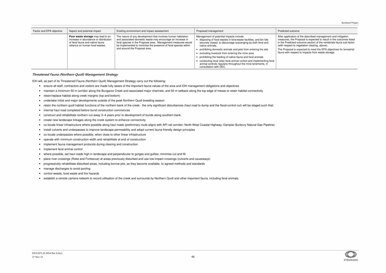
Buckland Project
IOH12073_01 R014 Rev 6.docx
27-Nov-13 46
Factor and EPA objective Aspect and potential impact Existing environment and impact assessment Proposed management Predicted outcome
Poor waste storage may lead to an increase in abundance or distribution of feral fauna and native fauna reliance on human food wastes.
The nature of any development that involves human habitation and associated domestic waste may encourage an increase in feral species in the Proposal area. Management measures would be implemented to minimise the presence of feral species within and around the Proposal area.
Management of potential impacts include:
• disposing of food wastes in bins/waste facilities, and bin lids securely closed, to discourage scavenging by both feral and native animals,
• prohibiting domestic animals and pets from entering the site
• excluding livestock from entering the mine area
• prohibiting the feeding of native fauna and feral animals
• conducting local (site) feral animal control and implementing feral animal controls regularly throughout the mine tenements, in consultation with DEC.
After application of the described management and mitigation measures, the Proposal is expected to result in the outcomes listed in the Predicted outcome section of the vertebrate fauna sub-factor (with respect to vegetation clearing, above).
The Proposal is expected to meet the EPA objectives for terrestrial fauna with respect to impacts from waste storage.
Threatened Fauna (Northern Quoll) Management Strategy
IOH will, as part of its Threatened Fauna (Northern Quoll) Management Strategy carry out the following:
• ensure all staff, contractors and visitors are made fully aware of the important fauna values of the area and IOH management obligations and objectives
• maintain a minimum 50 m corridor along the Bungaroo Creek and associated major channels, and 50 m setback along the top edge of mesas to retain habitat connectivity
• retain/replace habitat along creek margins (top and bottom)
• undertake initial and major developments outside of the peak Northern Quoll breeding season
• retain the northern quoll habitat functions of the northern bank of the creek - the only significant disturbances (haul road to dump and the flood-control cut) will be staged such that:
• internal haul road completed before bund construction commences
• construct and rehabilitate northern cut-away 3–4 years prior to development of bunds along southern bank.
• create new landscape linkages along the creek system to enhance connectivity
• co-locate linear infrastructure where possible along haul roads (preliminary route aligns with API rail corridor; North West Coastal Highway; Dampier-Bunbury Natural Gas Pipeline)
• install culverts and underpasses to improve landscape permeability and adopt current fauna-friendly design principles
• co-locate underpasses where possible, when close to other linear infrastructure
• operate with minimum construction width and rehabilitate at end of construction
• implement fauna management protocols during clearing and construction
• implement feral animal control
• where possible, set haul roads high in landscape and perpendicular to gorges and gullies; minimise cut and fill
• place river crossings (Robe and Fortescue) at areas previously disturbed and use low-impact crossings (culverts and causeways)
• progressively rehabilitate disturbed areas, including borrow pits, as they become available, to agreed methods and standards
• manage discharges to avoid pooling
• control weeds, food waste and fire hazards
• establish a remote camera network to record utilisation of the creek and surrounds by Northern Quoll and other important fauna, including feral animals.

Buckland Project
IOH12073_01 R014 Rev 6.docx
27-Nov-13 47
4.3.5 Environmental Factor: Subterranean fauna
Table 17 Environmental Factor: Subterranean fauna
Factor and EPA objective Aspect and potential impact Existing environment and impact assessment Proposed management Predicted outcome
Subterranean fauna:
To maintain representation, diversity, viability and ecological function at the species, population and assemblage level.
Pit excavation and operation may lead to removal of potential troglofauna habitat (potential loss of individual fauna through the extraction of material or vibration).
Troglofauna
Excavation of the mine pit will result in the direct removal of troglofauna habitat.
There may also be some minor vibration and/or compaction effects on subterranean habitat from the Proposal (e.g. blasting).
The survey area, which is located within the mine development envelope, contained widespread species as well as species that are so far known only from the proposed mine pits.
The most suitable geology for troglofauna is represented by the CID, alluvium and hardcap zone of the Dales Gorge Member BIF. The CID and the alluvium in the palaeodrainage channel, in particular, are well connected and form a single continuous geological unit that extends well beyond the proposed mine pits.
Approximately 40 troglofauna species are known from the survey area of which fifteen species, including ten singletons, are currently known only from the proposed mine pits (Table 6.1 of Bennelongia, 2013). Given that the smallest known range of a well sampled troglofauna species is 89 ha, in an area with strong topography and likely physical barriers to troglofauna movement, the 15 troglofauna species are unlikely to be restricted to the Western Pit, Eastern Pits and Dragon, with areas of 70, 94.7 and 34.7 ha, respectively.
This aspect of the distribution characteristics of troglofauna has been examined in more detail for the 15 species so far only known from the proposed mine pits (Bennelongia 2013). The detailed examination identified that, within the uncertainty of the available information, only one of the 15 species (Draculoides sp. B41) is possibly restricted to the BIF hardcap within the easternmost pit. However, Bennelongia (2013) recognises that the assessment is precautionary, as the easternmost pit is only 17.7 ha in extent and, in the absence of obvious topographic barriers, a troglofauna species is considered unlikely to have a range as small as this, and its range would probably extend south of the easternmost pit.
The distribution of the other 14 species has been assessed, based on records of similar species, or owing to the location of the record in relation to the proposed pit outline, as being unlikely to be restricted to the survey area (Table 7.1 of Bennelongia 2013).
Habitat characterisation, and the fact that 58% of the species collected at more than one drill hole in the survey area occurred in at least two pit areas, provide additional evidence to suggest that the species currently only known from the proposed mine pits are unlikely to be restricted to the proposed mine pit areas.
IOH will ensure that avoidable impacts to the subterranean environment are minimised, through responsible and systematic environmental management.
Management of potential impacts include:
• avoidance of disturbance to some areas of habitat by proposing to access only part of the entire orebody
• adherence to pit shell design, waste dump and low-grade fines storage facility boundaries.
The Proposal will result in the direct loss of subterranean fauna habitat, but the presence of good habitat connectivity beyond the Proposal reduces the risk likelihood of any species being restricted to the survey area.
Indirect impacts from hydrocarbon spills and clearing of vegetation area are not expected to be significant.
The Proposal is expected to meet the EPA objectives for subterranean fauna with respect to impacts from pit excavation and operation.
Hydrocarbon spills and AMD may lead to surface and groundwater contamination that has the potential to degrade habitat for troglofauna and/or stygofauna.
Contamination can result from hydrocarbon or wastewater spills.
The contamination of surface water, groundwater and soil has potential to result in degradation of the subterranean environment.
The impact assessment related to groundwater quality and surface water quality, directly addresses potential impacts on troglofauna habitat from contamination.
The risk of potential hydrocarbon spills would be minimised though application of management, monitoring and contingency measures that will be implemented as part of the Proposal and described under the surface water and groundwater sections above.
After application of the described management and mitigation measures, the Proposal is expected to result in the outcomes listed in the Predicted outcome section of the troglofauna sub-factor.
The Proposal is expected to meet the EPA objectives for subterranean fauna with respect to impacts from hydrocarbon spills.
Clearing of vegetation may lead to a reduction of organic inputs.
The clearing of vegetation beyond the mine footprint can potentially lead to a reduction in the availability of organic inputs to underlying subterranean habitats, which may lead to a reduction in abundance and diversity.
The proposed clearing of vegetation outside of mine pit areas is not expected to have a significant effect on the subterranean fauna in addition to the effects of mining. The management of vegetation clearing is discussed further under Flora and Vegetation.
The key potential impact of the Proposal on troglofauna due to clearing will generally be minimised via management measures to minimise potential impacts on flora and vegetation, as detailed under Flora and Vegetation (Section 4.3.3).
After application of the described management and mitigation measures, the Proposal is expected to result in the outcomes listed in the Predicted outcome section of the troglofauna sub-factor.
The Proposal is expected to meet the EPA objectives for subterranean fauna with respect to impacts from the clearing of vegetation.

Buckland Project
IOH12073_01 R014 Rev 6.docx
27-Nov-13 48
Factor and EPA objective Aspect and potential impact Existing environment and impact assessment Proposed management Predicted outcome
Pit dewatering may lead to drawdown and impact on stygofauna habitat.
Stygofauna
De-watering of the Western Pit and Eastern Pits areas will be undertaken to allow access approximately 24% of the below watertable ore in the CID.
Sampling (Figure 34) of the stygofauna community recorded 1832 specimens representing 10 higher taxonomic levels and approximately at least 28 species (Bennelongia 2013).
Nine species are currently known only from within the survey area with an additional three only indentified to family or genus level and considered restricted to the survey area. On the basis of existing data, 12 species are known only from within the Survey Area; this includes nine identified species and three taxa identified only to family or genus (the ranges of two species – a nematode and rotifer - were not assessed).
Based on existing information on the distributions of Pilbara stygofauna, it is unlikely that the 12 stygofauna species only known from the Survey Area are actually restricted to that area. However, a review of the ranges of taxonomically similar species suggested it is possible that five of the 12 species have ranges not much larger than the Survey Area (Bennelongia 2013).
Habitat characterisation showed that the CID/alluvial aquifer in palaeochannels of the Robe and Bungaroo catchments, which occurs both upstream and downstream of the Proposal, potentially provides considerable habitat connectivity for stygofauna beyond the Proposal. This connectivity appears to reduce the likelihood of any species actually being restricted to the Survey Area (Bennelongia 2013).
The CID thickness is approximately 150 m in its deepest sections, with at least 50 m of overlying alluvium, and the CID is generally fully saturated with high porosity and a significant storage volume (RPS 2013a). The CID aquifer extends to at least the proposed BCWSB, approximately 19 km downstream of the West Pit.
This wide distribution and high porosity would serve to reduce the risk likelihood of any species being restricted to the Survey Area (Bennelongia 2013).
Design and management measures to address hydrocarbon contamination and AMD impacts have been discussed previously.
IOH will ensure that avoidable impacts to the subterranean environment are minimised, through responsible and systematic environmental management.
The Proposal will result in a reduction in the extent of habitat for stygofauna through excavation and dewatering (predominantly the latter as only 24% of the below-watertable deposit will be recovered), however, the good connectivity between the CID and contiguous alluvial deposits is very high and extends far beyond the predicted drawdown zone.
Indirect impacts from hydrocarbon spills and AMD are not expected to be significant and would be unlikely to result in extensive (habitat-wide) adverse outcomes in the worse case.
The Proposal is expected to meet the EPA objectives for subterranean fauna with respect to impacts from dewatering and groundwater contamination.

Buckland Project
IOH12073_01 R014 Rev 6.docx
27-Nov-13 49
4.4 Consolidated management commitments
Table 18 Consolidated management commitments
Aspect Management Plan Purpose Scope Associated secondary approvals
Water Source Protection
Bungaroo South Mine Catchment Protection Strategy (MCPS)
To direct the detailed design of the Buckland Project and guide the preparation of Environmental Management Plans (EMPs), site access protocols and relevant work procedures in a systematic fashion so that, in principle, the risks to the P1 Water Reserve associated with the Proposal are avoided as appropriate, guided by relevant guidelines and policies.
• set water quality targets
• establish and maintain the following registers:
* legal and policy obligations and commitments
* performance objectives
* risk register
* stakeholders, including interested and affected parties
* training and awareness requirements
* reporting requirements
* research and improvement priorities
• through the obligations and risk registers, specify the management objectives and scopes of other relevant management plans and programs
s 5C application (DoW)
Works Approval application (DER)
Mining Proposal – minesite and camp (DMP)
Water Source Protection:
Closure
Acid and Metalliferous Drainage EMP
To ensure the management of mine materials and water is conducted in a manner that satisfactorily protects the BCWSB from acidic and/or metalliferous drainage, during operations and after closure.
• a waste material characterisation program (including kinetic testing) that will significantly add to the understanding of the waste materials that will constitute the backfill
• a groundwater monitoring network based on modelled groundwater flow paths
• brief overview of currently available options to quantify and address groundwater contamination in the event that trigger levels are breached or concerning trends are identified (e.g. pump and treat, in-situ neutralisation/ bioremediation).
s 5C application (DoW)
Works Approval application (DER)
Mining Proposal – minesite and camp (DMP)

Buckland Project
IOH12073_01 R014 Rev 6.docx
27-Nov-13 50
Aspect Management Plan Purpose Scope Associated secondary approvals
Water Source Protection:
Dewatering
Dewatering and Disposal EMP
To ensure that IOH complies with its legal and community obligations and environmental objectives with regards to the abstraction and disposal of groundwater.
• track abstraction and re-injection water quality and volumes
• describe design, operation and maintenance of the abstraction and reinjection systems, including balancing tanks and continuous monitoring systems
• define the types (sources), volumes and quality of water can be discharged through the reinjection system
• set management objectives and performance criteria for the reinjection and contingency surface disposal systems, which, in addition to water quality aspects, would include to minimise soil saturation and erosion; prevent formation of permanent or semi-permanent pools; minimise groundwater mounding
• outline a regional groundwater monitoring network to track changes in groundwater level and chemistry, both up and down gradient of the mine and reinjection areas
• describe appropriate responses, including diversion and treatment options, if abstraction water quality begins to deteriorate below expected parameters, or impacts are detected at the reinjection/alternative disposal areas.
s 5C application (DoW) on advice from DPaW
Water Source Protection:
Site Drainage Management Plan
To ensure that the protection of ground and surface water quality is integrated into the designs and operations of mining support facilities and infrastructure.
• stormwater diversion around disturbed areas, including waste landforms and the plant site
• stabilisation and other sediment controls, including sedimentation basins
• how runoff from high risk areas (i.e. where hydrocarbons are stored or transferred, or where vehicles are cleaned and serviced) will be minimised (roofing), collected (lined facilities), treated (settling ponds, oily water separators) and stored (lined storage ponds)
• water quality indicators for re-use, discharge to surface water or re-treatment and/or specialist disposal.
s 5C application (DoW)
Works Approval application (DER)

Buckland Project
IOH12073_01 R014 Rev 6.docx
27-Nov-13 51
Aspect Management Plan Purpose Scope Associated secondary approvals
Water Source Protection:
Closure
Waste Fines Storage Facility (WFSF) Operating Plan
To ensure that waste fines are deposited and stored in a systematic way that optimises use of the WFSF and has minimal environmental impact.
• the location, layout and basis of design for the WFSF, including decant and seepage collection and return systems
• sub-catchment stormwater diversion
• maximum storage, flood storage, freeboard and spillway dimensions (facilities will be designed not to overtop in PMF)
• a water balance for the WFSF
• safeguards and groundwater monitoring systems
• a general overview of the decommissioning (complete removal for backfill) and site rehabilitation objectives
• an assessment of the WFSF design and proposed operation against DOW Water Quality Protection Guidelines.
s 5C application (DoW)
Mining Proposal – minesite and camp (DMP)
Threatened Fauna
Threatened Fauna (Northern Quoll) Management Strategy
To develop the plans and procedures to ensure that the potential impacts to individuals, populations and habitat as a result of its operations are managed in accordance with the objectives and performance requirements identified in the environmental assessment and approval processes for the Buckland Project.
• threat assessment
• design principles and management approaches for the construction of the mine, bunds, haul road and drainage systems and, where relevant, their operation and eventual closure
• monitoring and review
DotE
Water Source Protection:
Closure
Mine Closure Plan To ensure mine closure is properly planned and implemented in an ecologically sustainable manner, consistent with agreed post mining outcomes and land uses, and without unacceptable liability to the State.
To address DMP/EPA guidelines on mine closure plans
Describe and plan for the: • identification of closure obligations and commitments
• collection and analysis of closure data
• stakeholder consultation
• post-mining land use and closure objectives
• identification and management of closure issues
• development of completion criteria
• financial provision for closure
• closure implementation
• closure monitoring and maintenance
• management of information and data.
s 5C application (DoW)
Mining Proposal – minesite and camp (DMP)

Buckland Project
IOH12073_01 R014 Rev 6.docx
27-Nov-13 52
Aspect Management Plan Purpose Scope Associated secondary approvals
Water Source Protection
Emergency Response Plan
To ensure that, in the event of an emergency, people have adequate understanding and resources to identify and respond to emergency events that have the potential to impact catchment water quality.
To integrate emergency awareness, planning and response at the Buckland site with other emergency managers in the district.
• key hazards and routine responses
• responsibilities, including control and notification
• emergency contacts
• training and awareness
• resources to respond to emergencies
• incident investigation
• interaction with district and State Emergency Management frameworks and networks.
s 5C application (DoW)
Performance monitoring
Environmental Monitoring Program
To ensure that environmental management assessment and decision making processes are provided with adequate, accessible and reliable environmental data.
• location of monitoring points
• sampling and inspection methods
• monitoring schedule
• data storage
• instrumentation maintenance schedule
• quality assurance
All
Construction (compliance)
Mine and camp construction EMP
To ensure that the construction of the Project complies with relevant approvals and construction personnel are aware of environmental obligations and risks.
Sets out:
• requirements for contractors with regards to environmental management systems and procedures, including training, responsibilities and auditing compliance
• specifies the measures that the contractor must implement to protect, amongst other things, vegetation and flora, fauna and water resource.
• handover arrangements
• incident response
• communication and reporting schedules.
Mining Proposal – minesite and camp (DMP)
Works Approval application (DER)
Construction (compliance)
Haul road construction EMP
To ensure that the construction of the Project complies with relevant approvals and construction personnel are aware of environmental obligations and risks.
Mining Proposal – haul road (DMP)

Buckland Project
IOH12073_01 R014 Rev 6.docx
27-Nov-13 53
5. Other potential impacts and activities
Table 19 briefly outlines potential impacts and activities, and their management, associated with other environmental factors or issues relevant to the Proposal that were not identified as key factors in the Category A - EPA-prepared scoping guideline, dated 12 February
2013. These other factors and issues can be regulated by other government agencies under other statutes.
Table 19 Other environmental impacts and activities – other legislation and approvals
Environmental factor or issue
Description of impact or activity Approval mechanism Responsible agency Statute Management and Mitigation
Greenhouse gas emissions
The major contributors to greenhouse gas (GHG) emissions from the Proposal will be mobile equipment, crushing and conveying of ore.
GHG emissions have been estimated for the proposed operations at 4 Mtpa (Stage 1) and 8 Mtpa (Stage 2). Emission sources considered include power generation and vehicles/machinery (road trains, light vehicle fleet and mining fleet).
Fuel consumption for each stage has been estimated as follows (SKM 2012):
• Stage 1: 16 428 kL/yr
• Stage 2: 31 025 kL/yr.
GHG emissions are estimated to be:
• Stage 1: 44 193 t CO2-e/yr
• Stage 2: 83 437 t CO2-e/yr.
National Greenhouse and Energy Reporting (NGER) Scheme
Australian Government (Clean Energy Regulator)
National Greenhouse and Energy Reporting Act 2007
The Proponent is committed to minimising emissions to levels as low as reasonably practicable on an ongoing basis through implementation of the following management actions:
• reporting GHG emissions in accordance with National Greenhouse and Energy Reporting (NGERS) requirements
• complying with the Australian Clean Energy Act 2011 (carbon pricing system and emissions trading scheme).
• Implementation of GHG and energy conservation measures would reduce emissions and provide a mechanism for continuous improvement in GHG emissions resulting from the Proposal.
Aboriginal heritage Aboriginal heritage sites have been identified in and around the Proposal area. The Proponent remains in close consultation with the Kuruma Marthudunera (KM) and Yaburara Mardudhunera (YM) claimant groups and will also engage with the Department of Indigenous Affairs as required during the approvals process in accordance with the Aboriginal Heritage Act 1972 (AH Act). A land use agreement was signed with the KM claimant group in October 2012 and the YM claimant group in November 2012.
Heritage sites will be avoided where possible and correct management measures are in place to minimise any potential impacts.
Section 18 consent to disturb a heritage site
Department of Aboriginal Affairs (DAA)
Aboriginal Heritage Act 1972
The Proponent will ensure it honours its commitments detailed in the Native Title Agreements.
The Proponent has committed to maintaining water flows within the existing creek system, which has cultural significance, without the requirement to construct significant diversions.
The Proponent has agreed to preserve several significant burial sites within the mine area, sterilising parts of the orebody in the vicinity of the West Pit
Aboriginal heritage values will also be addressed during planning and implementation of the Proposal by:
• avoiding disturbance to heritage sites as per Native Title Agreements
• obtaining approval for any required disturbance to identified sites in accordance with s. 18 of the AH Act
• protecting all identified sites located near construction or operational areas that are not approved to be disturbed under s. 18 of the AH Act (e.g. through the installation of physical barriers)
• documenting the location of all protected sites in a Geographic Information System (GIS) database and on site plans
• working with the KM and YM people to ensure heritage values are maintained appropriately
• establishing heritage protocols and cultural awareness training for all employees.
Management actions for Aboriginal heritage will be further detailed in an Aboriginal Culture and Heritage Management Plan to be developed for the Proposal.
Air quality (dust) Dust will be generated as a result of the Proposal primarily through construction clearing and earthworks, blasting, materials handling, crushing and processing of ore and haulage and light traffic on unsealed roads.
Works Approval and Licence to Operate for prescribed premises – e.g. Category 5, crusher and conveyor
DEC Environmental Protection Act 1986
Management measures to minimise dust will include:
• the application of water (or appropriate suppressants) to haul roads, working surfaces and stockpiles (as required)
• incorporation of dust controls in key infrastructure, such as water sprays at the ROM bin, and dust collectors at major dust generating centres (primary crusher, conveyor transfers)
• implementing and enforcing appropriate vehicle speed limits on site access roads.
Management and monitoring actions for air quality will be detailed in an Environmental Management Plan to be developed for the Proposal.
Hazardous materials The Proposal would involve the use of a number of hazardous materials.
An indicative list of the types of hazardous materials that may be used includes (but is not limited to):
• fuels including distillate and liquefied petroleum gas
• oil, greases, coolants and degreasers
• ammonium nitrate. I
Inappropriate handling and/or storage of hazardous materials has the potential to result in discharges to the environment (i.e. contamination) and create health or safety hazards.
Dangerous Goods Licence DMP, Resources Safety Branch
Dangerous Goods Safety Act 2004
All hazardous material storage facilities will comply with the Dangerous Goods Safety Act 2004 and associated Dangerous Goods Safety Regulations 2007, at a minimum.
Management and monitoring actions for hazardous materials will be further detailed in an Environmental Management Plan to be developed for the Proposal.
Surface water hydrology Interference with watercourses Permit to obstruct or interfere with bed/banks
DoW Rights in Water and Irrigation Act 1914
Refer to Section 4.3.1
Groundwater supplies Groundwater abstraction of up to 1.36 GL/a for processing, dust suppression and potable water supply. To be sourced primarily from dewatering, supplemented by a borefield if and as required.
Licence to construct or alter wells
Licence to take groundwater/amendment to existing groundwater licences
DoW Rights in Water and Irrigation Act 1914
Refer to Section 4.3.1

Buckland Project
IOH12073_01 R014 Rev 6.docx
27-Nov-13 54
Environmental factor or issue
Description of impact or activity Approval mechanism Responsible agency Statute Management and Mitigation
Groundwater contamination
Dewatering discharge Licence to Operate for prescribed premises –e.g. Category 6, dewatering and discharge
DEC Environmental Protection Act 1986
Refer to Section 4.3.2
Rehabilitation and closure
Activities and impacts of the Proposal most relevant to rehabilitation and closure include:
• pit bunds – presence of large artificial structures within the confines of the Bungaroo Creek will affect the natural hydrological regime of the creek system and may be unstable or unsafe in the long term
• pit voids – potential for creation of permanent lakes on recovery of watertable to pre-mining levels which has the potential to adversely impact groundwater
• waste dumps – if not designed, constructed and rehabilitated correctly these permanent landforms may lead to unacceptable levels of erosion, contaminant/acid leachate and support weedy or poorly revegetated habitat
• processing, dewatering, dewater disposal, haul roads, borrow pits, river crossing infrastructure and other miscellaneous infrastructure (e.g. mine camp, landfill) – potential for erosion, soil and water contamination, weedy or poorly revegetated habitat.
Mining Proposal and Mine Closure Plan – for infrastructure on Mining Act tenure
DMP Mining Act 1978 A Mine Closure Plan (MCP) will be prepared to satisfy the requirements of the ANZMEC/MCA Strategic Framework for Mine Closure (ANZMEC/MCA 2000). This will be based on the methodology and approaches outlined in the DMP/EPA Guidelines for Preparing Mine Closure Plans (DMP and EPA 2011) and Department of Industry, Tourism and Resources (DITR) Leading Practice Sustainable Development in Mining (DITR 2008) handbooks and the Planning for Integrated Mine Closure: Toolkit (ICMM 2008).
Assessment of the MCP will be addressed under the Mining Act 1978 through the Mining Proposal application and approval process.
Management strategies to be incorporated into the MCP include:
4. Rehabilitation requirements integrated into site clearing and development procedures, such as:
a. survey and mapping
b. targeted seed collection
c. raised-blade clearing
d. topsoil recovery and stockpiling, with cleared vegetation spread over stockpiles.
5. Rehabilitation based on leading practice for industry and the area, for example:
a. backfill to above (pre-disturbance) watertable to prevent permanent pools
b. construct integrated drainage
c. plan for prioritisation of erosion management
d. deep rip across contour prior to topsoil respreading
e. re-seed if required (based on monitoring)
f. construct fauna habitats if material available
g. remove litter, contaminated soil, infrastructure, etc.
h. decommission all bores to DOW requirements.
i. rehabilitation of borrow pits, graded and contoured to allow egress of small terrestrial vertebrate fauna.
6. Rehabilitation of other landforms:
a. a substantial proportion of the waste rock dump will be removed as backfill and the underlying areas
rehabilitated
b. the WFSF will be (if not re-mined for pit backfill) capped with an engineer-designed inert cover (any
requirements for the addition of neutralising material such as lime will be determined prior to closure)
c. a single drainage collection point will be incorporated into the design and this will be managed
dependent on monitoring results (e.g. passive treatment).
Public risk and safety The Proposal will require traffic management on the North-West Coastal Highway and Pannawonica Road, both of which are public roads.
Mining Proposal (includes other environmental aspects also) – for infrastructure on Mining Act tenure
DMP, Resources Safety Branch
Mining Act 1978 Management measures to minimise the risk to public safety include:
• all road interactions (e.g. heavy vehicle access, signage, etc.) will be carried out in accordance with the requirements of the relevant road authority and relevant legislation
• transport of any fuel, explosives or hazardous materials will be undertaken in accordance with the Dangerous Goods Safety Act 2004 and associated Dangerous Goods Safety Regulations 2007
• IOH will prepare a Road Safety Strategy in consultation with MRWA
• maximum fleet size will be decided in consultation with MWRA
• IOH vehicles will adhere to acceptable highway speeds as agreed by MRWA, such that vehicles are able to merge and operate with general traffic
• emissions standards for vehicles will be in accordance with the Australian Design Rules
• IOH vehicles travelling on public roads will require permits and will be required to weigh in at designated weighbridges
• scheduling of fleet movements will, where possible, be designed to minimise impact on other road users - for example, scheduling will consider maximising trips occurring during night hours, when general road traffic movements and ambient temperatures are at their lowest, allowing equipment to operate at or close to maximum efficiency.
Non-mineral waste The Proposal will generate non-mineral waste that will require disposal both on-site and off-site, including:
• domestic solid and liquid wastes (including general office waste)
• general mine site waste (including scrap metal, drums, tyres)
• controlled waste (e.g. paints, acids, hydrocarbons, batteries)
• sewage.
Works Approval and Licence to Operate for prescribed premises – e.g. Category 63/64, Landfill
DEC Environmental Protection Act 1986
Environmental Protection (Rural Landfill) Regulations 2002
Management measures to reduce the impact of non-mineral waste will include:
• 500 tonnes per year estimated maximum capacity. To be licensed in accordance with the Environmental Protection (Rural Landfill) Regulations 2002
• integrated ablution facilities linked to ‘Biomax’ or similar type plants with an approximate capacity of 15 kilolitres per day.
Application to construct or install an apparatus for the treatment of sewage
Shire of Ashburton/DoH Health (Treatment of Sewage and Disposal of Effluent and Liquid Waste) Regulations 1974

Buckland Project
IOH12073_01 R014 Rev 6.docx
27-Nov-13 55
Environmental factor or issue
Description of impact or activity Approval mechanism Responsible agency Statute Management and Mitigation
Power supply 4 MW diesel–fuelled power station, expanding to 8 MW once below-watertable mining commences.
Mining Proposal.
If it is found that the power supply is to be located on a prescribed premise detail of the power supply will be included in the Works Approval under Section 53 of the EP Act.
DMP/DEC Mining Act 1978
Environmental Protection Act 1986
The Proponent is committed to minimising emissions to levels as low as reasonably practicable on an ongoing basis and will operate in accordance with relevant legislation and guidelines.

Buckland Project
IOH12073_01 R014 Rev 6.docx
27-Nov-13 56
This page is intentionally blank

Buckland Project
IOH12073_01 R014 Rev 6.docx
27-Nov-13 57
6. Cumulative impacts
This section addresses how the Proposal may contribute to any cumulative impacts of existing projects on
flora and vegetation, terrestrial and subterranean fauna and hydrological processes in the region.
The mine area of the Proposal is not located in proximity to any other significant mining development. The
nearest mine site is the Rio Tinto Mesa J operation, downstream of the Proposal and approximately 25 km
to the north-west in the vicinity of the BCWSB and the Jimmawurrada Creek junction. The most significant
developments in the vicinity of the proposed haul road are the approved, but yet to be constructed, API rail
corridor and, possibly, the Goldfield Gas Pipeline (GGP) and Dampier to Bunbury Natural Gas Pipeline
(DBNGP). The potential cumulative impacts arising from the Proposal in relation to these developments
are addressed in Table 20.
Table 20 Cumulative impact assessment
Factor Cumulative impacts
Inland waters (environmental quality)
There are no other mining operations within the Bungaroo Creek South catchment and the cumulative impact will be limited to that of the Buckland Project.
The mine part of the Proposal is located within the Bungaroo Creek Water Reserve, which is a future groundwater source for the supply of drinking water into the West Pilbara Water Supply Scheme. Cumulative impacts on inland waters have been addressed in Key environmental
factors and management (Section 4.3.2).
The haul road part of the Proposal will have no foreseeable significant cumulative impact on the environmental quality of inland waters.
Hydrological processes (surface water and groundwater)
There are no other mining operations within the Bungaroo Creek South catchment and the cumulative impact will be limited to that of the Buckland Project.
The mine part of the Proposal is located within the Bungaroo Creek Water Reserve, which is a future groundwater source for the supply of drinking water into the West Pilbara Water Supply Scheme. Cumulative impacts on hydrological processes have been addressed in Key
environmental factors and management (Section 4.3.1) through modelling of the superimposed effects of the Proposal and the effects and the BCWSB.
The haul road part of the Proposal has the potential for limited cumulative impact on surface water where it is located adjacent to the GGP and proposed API rail corridor; however, no significant cumulative impacts on groundwater processes are anticipated.
The preferred Stage 1 haul road route is located generally adjacent to the GGP and proposed API rail corridor and will intersect the same watercourses along most of its length. These include the Robe River crossing as well as numerous minor creeklines. The preferred Stage 2 haul road route is located adjacent to the DBNGP for a substantial proportion of its length. This section of road will intersect the same watercourses as the pipeline, including the Fortescue River. Potential cumulative impacts will be avoided by ensuring drainage structures, most significantly with respect to culverts at larger creek crossings, are aligned with similar structures on the neighbouring infrastructure in order to minimise interference with natural flow regimes. No cumulative impacts are anticipated at the two main rivers as the:
• road crossing will be designed to minimise any affect on flow regimes
• DBNGP is buried at the Fortescue River crossing (and at other watercourses)
• API bridge structures will be designed to not impede periodic flood events (API 2010).
Flora and vegetation The main potential cumulative effect on vegetation and flora is the combined effect of clearing vegetation communities from the Proposal and the API West Pilbara Iron Ore Project along the respective transport corridors. The potential maximum proportion of clearing of Pre-European vegetation sub-associations and Land System units has been used to estimate potential cumulative impact (Appendix 1). Potential disturbance areas are available for this Proposal only (relevant disturbance areas for the API proposal were not available for this assessment). The Proposal is estimated to affect no more than 2.79% of any Pre-European vegetation sub-association and no more than 0.34% of any Land System unit, as the API proposal is of similar dimensions where it is co-located with the Proposal it is anticipated it would affect a similar proportion of the aforementioned units.
Furthermore, the potential cumulative impacts will be considerably less than those estimated, given that impact calculations for this Proposal have been computed using the development envelope for both mine and road, an area of 8800 ha, whereas the actual estimated clearing footprint is 2050 ha (Table 2).

Buckland Project
IOH12073_01 R014 Rev 6.docx
27-Nov-13 58
Factor Cumulative impacts
Terrestrial fauna The Proposal will affect no more than 0.34% of any one land system intersected (refer to above table in the vegetation and flora section). The cumulative effect on the fauna present as a result of the Project is consequently expected to be insignificant.
Subterranean fauna Mine dewatering drawdown will overlap with potential drawdown from the proposed BCWSB and; therefore, result in a cumulative impact on stygofauna habitat. The alluvial/CID aquifer (i.e. stygofauna habitat) of the Bungaroo Creek palaeochannel is extensive and is considered to be well connected (Bennelongia 2013). Maximum drawdown of the aquifer during the life of the mine is expected to occur after five years, which will be the point at which maximum cumulative impact on stygofauna habitat will occur, after which groundwater levels as a result of mine dewatering are expected to commence recovery.
Further assessment of cumulative impact in terms of drawdown of the aquifer as a result of the combined effect of the Proposal and the BCWSB is provided in Key environmental factors and
management (Section 4.3.5).
There are no other mining operations in the vicinity of the Proposal and; therefore, there are no potential cumulative impacts anticipated on troglofauna.

Buckland Project
IOH12073_01 R014 Rev 6.docx
27-Nov-13 59
7. Offsets
Appendix 4 presents the offsets reporting form in which the significant residual environmental impacts
have been determined. The residual environmental impacts have been determined after all other
environmental impact mitigation measures have been accounted for in accordance with EPA Guidance
Statement No. 19: Environmental offsets – biodiversity and EPA Position Statement No. 9 Environmental
Offsets. The EPA has also prepared a draft Environmental Assessment Guideline for Environmental
Offsets to provide guidance on determining the circumstances under which offsets may be required, and
how to develop an appropriate offset package.
Based on these guidelines, the residual environmental impacts have been determined as comprising
clearing and direct disturbance of approximately 2050 ha of vegetation in good to pristine condition.
IOH proposes to provide monetary support to assist in the conservation of vegetation in the region and the
funding of an on-going monitoring and research program to determine the effectiveness of best practice
management measures on local populations of Northern Quoll, over a 20-year timeframe. The details of
this research program are attached (Appendix 6 [included with the draft Northern Quoll Management Plan])
and will reduce uncertainties in future environmental impact assessments and improve management
outcomes with regards to Northern Quoll on an Australian-wide basis. Specific details concerning
monetary and in-kind support will be decided in negotiation with OEPA once the forward cost estimates of
ongoing Northern Quoll studies (committed to under the EPBC Act assessment process) have been
finalised.

Buckland Project
IOH12073_01 R014 Rev 6.docx
27-Nov-13 60
8. References
Australian and New Zealand Environment and Conservation Council & Agriculture and Resource
Management Council of Australia and New Zealand (ANZECC/ARMCANZ) 2000, Australian and New
Zealand Guidelines for Fresh and Marine Water Quality, Australian Water Association, Sydney.
API Management Pty Ltd & Strategen Environmental Consultants Pty Ltd 2010, West Pilbara Iron Ore
Project Stage 1 Mine and Rail Proposal, Public Environmental Review, June 2010, API Management
Pty Ltd, Perth.
Australian and New Zealand Minerals Energy Council/Mineral Council of Australia (ANZMEC/MCA) 2000,
Strategic Framework for Mine Closure, Canberra.
Australian National Committee on Large Dams Inc. (ANCOLD) 2012. Guidelines on Tailings Dams –
Planning, Design, Construction, Operation and Closure, May 2012.
Beard JS 1975, Pilbara, Explanatory Notes and Map Sheet 5, 1:1 000 000 Series Vegetation Survey of
Western Australia, University of Western Australia Press, Nedlands.
Beard JS 1990, Plant Life of Western Australia, Kangaroo Press, Sydney.
Bennelongia 2013, Bungaroo South: Subterranean Fauna Assessment, unpublished report prepared for
Iron Ore Holdings Limited, April 2013.
Biota Environmental Sciences Pty Ltd 2007a, Rare Flora Survey of Bungaroo Trial Pit Project Borrow Pits,
prepared for Rio Tinto Iron Ore, Perth.
Biota Environmental Sciences Pty Ltd 2007b, A Vegetation and Seasonal Flora Survey of the Bungaroo
Trial Pit and Transport Corridor to Mesa J, near Pannawonica and Sampling of the Broader Bungaroo
Valley, prepared for Rio Tinto Iron Ore, Perth.
Biota Environmental Sciences Pty Ltd 2011, Greater Bungaroo and Coastal Water Project Biological
Review, prepared for Rio Tinto Iron Ore, Perth.
Burbidge NT 1959, Notes on Plants and Plant Habitats observed in the Abydos-Woodstock area, Pilbara
District, Western Australia, CSIRO Div. Plant Ind. Tech. Paper 12, Commonwealth Scientific and
Industrial Research Organization, Melbourne.
Department of Conservation and Land Management (CALM) 2002, Botanical Survey of Hamersley Range
Uplands, National Reserve System Project N709, May 2002, Government of Western Australia.
Department of Environment (DoE) 2004, Land Use Compatibility in Public Drinking Water Source Areas,
Water Quality Protection Note, Government of Western Australia.
Department of Industry, Tourism and Resources (DITR) (Now Department of Resources Energy and
Tourism) 2008, Leading Practice Sustainable Development in Mining handbooks, [Online], Available
from:
http://www.ret.gov.au/resources/resources_programs/lpsdpmining/handbooks/Pages/default.aspx.
Department of Mines and Petroleum (DMP) and Environmental Protection Authority (EPA) 2011,
Guidelines for Preparing Mine Closure Plans, Government of Western Australia, Perth.
Department of Mines and Petroleum (DMP) 2013, Tailings storage facilities in Western Australia, Draft for
public comment. [Online], Government of Western Australia, Available from
http://www.dmp.wa.gov.au/documents/Code_of_Practice/MSH_COP_TailingsStorageFaciltiesWA_-
_DRAFT.pdf, [23 September 2013].

Buckland Project
IOH12073_01 R014 Rev 6.docx
27-Nov-13 61
Department of Sustainability, Environment, Water, Population and Communities (DSEWPaC) 2012a,
Australia’s Bioregions (IBRA) [Online], Available from:
http://www.environment.gov.au/parks/nrs/science/bioregion-framework/ibra/index.html#ibrabioregions
[16 October 2012].
Department of Sustainability Environment Water Population and Communities (DSEWPaC) 2012b,
Environmental Protection and Biodiversity Conservation Act 1999 Environmental Offsets Policy,
[Online], Available from: http://www.environment.gov.au/epbc/publications/pubs/offsets-policy.pdf [15
October 2012].
Department of Water (DoW) 2009, Pilbara Water in Mining Guideline, Water resource allocation planning
series, Report No. 34, Government of Western Australia, Perth, September 2009.
Department of Water (DoW) 2012, Western Australian Water in Mining Guideline, Water licensing delivery
series, Report No. 12, Government of Western Australia, Perth, June 2012.
Department of Water (DoW) 2012, Bungaroo Creek Water Reserve Drinking Water Source Protection
Plan, Report WRP 135, [Online], Government of Western Australia, Available from
http://www.water.wa.gov.au/PublicationStore/first/104046.pdf [23 September 2013.
Environmental Protection Authority (EPA) 2000, Position Statement No. 2, Environmental Protection of
Native Vegetation in Western Australia: Clearing of Native Vegetation, with Particular Reference to
the Agricultural Area, Environmental Protection Authority, Perth.
Environmental Protection Authority (EPA) 2002, Position Statement No. 3, Terrestrial Biological Surveys
as an Element of Biodiversity Protection, Environmental Protection Authority, Perth.
Environmental Protection Authority (EPA) 2003, Guidance Statement No. 54, Guidance for the
Assessment of Environmental Factors, Consideration of Subterranean Fauna in Groundwater and
Caves during Environmental Impact Assessment in Western Australia, Environmental Protection
Authority, Perth.
Environmental Protection Authority (EPA) 2004a, Guidance Statement No. 51, Guidance for the
Assessment of Environmental Factors, Terrestrial Flora and Vegetation Surveys for Environmental
Impact Assessment in Western Australia, Environmental Protection Authority, Perth.
Environmental Protection Authority (EPA) 2004b, Guidance Statement No. 56, Guidance for the
Assessment of Environmental Factors, Terrestrial Fauna Surveys for Environmental Impact
Assessment in Western Australia, Environmental Protection Authority, Perth.
Environmental Protection Authority (EPA) 2006a, Guidance Statement No. 6, Guidance for the
Assessment of Environmental Factors, Rehabilitation of Terrestrial Ecosystems, Environmental
Protection Authority, Perth.
Environmental Protection Authority (EPA) 2006b, Position Statement 9. Environmental Offsets,
Environmental Protection Authority, Perth.
Environmental Protection Authority (EPA) 2007, Draft Guidance Statement No. 54a, Guidance for the
Assessment of Environmental Factors, Sampling Methods and Survey Considerations for
Subterranean Fauna in Western Australia, Environmental Protection Authority, Perth.
Environmental Protection Authority (EPA) 2008, Guidance Statement No. 19, Guidance for the
Assessment of Environmental Factors, Environmental Offsets – Biodiversity, Environmental
Protection Authority, Perth.
Environmental Protection Authority (EPA) 2009, Guidance Statement No. 20, Guidance for the
Assessment of Environmental Factors, Sampling of Short Range Endemic Invertebrate Fauna for
Environmental Impact Assessment in Western Australia, Environmental Protection Authority, Perth.
Environmental Protection Authority (EPA) 2010a, Environmental Assessment Guideline No. 6, Timelines
for Environmental Impact Assessment of Proposals, Environmental Protection Authority, Perth.

Buckland Project
IOH12073_01 R014 Rev 6.docx
27-Nov-13 62
Environmental Protection Authority (EPA) 2010b, Technical Guide – Terrestrial Vertebrate Fauna Surveys
for Environmental Impact Assessment, Environmental Protection Authority, Perth.
Environmental Protection Authority (EPA) 2012a, Environmental Assessment Guideline No. 1, Defining the
Key Characteristics of a Proposal, Environmental Protection Authority, Perth.
Environmental Protection Authority (EPA) 2012b, Draft Environmental Assessment Guideline for
Environmental Offsets, Environmental Protection Authority, Perth.
Gentilli J 1972, Australian Climate Patterns, Nelson, Melbourne.
Government of Western Australia 2011, WA Environmental Offsets Policy, Government of Western
Australia, Perth.
R Green and R K Borden 2011, Geochemical Risk Assessment Process for Rio Tinto’s Pilbara Iron Ore
Mines, Integrated Waste Management - Volume I. Mr. Sunil Kumar (Ed.), ISBN: 978-953-307-469-6,
InTech, DOI: 10.5772/20473. Available from: http://www.intechopen.com/books/integrated-waste-
management-volume-i/geochemical-risk-assessment-process-for-rio-tinto-s-pilbara-iron-ore-mines.
International Council on Mining & Metals (ICMM) 2008, Planning for Integrated Mine Closure: Toolkit,
ICMM, London.
Kendrick P 2003, Pilbara 3 (PIL3, Hamersley Subregion), in A Biodiversity Audit of Western Australia’s 53
Biogeographical Subregions, Department of Conservation and Land Management, Perth.
National Health and Medical Research Council & Natural Resource Management Ministerial Council
((NHMRC & NRMMC) 2011, Australian Drinking Water Guidelines 6 National Water Quality
Management Strategy, Australian Government, Canberra.
McKenzie NL, van Leeuwen S & Pinder AM 2009, ‘Introduction to the Pilbara Biodiversity Survey, 2002-
2007’ in Records of the Western Australian Museum, Supplement, 78: 3–89, pp. 3–90.
Onshore Environmental (Onshore) 2013a, Flora and Vegetation Survey, Buckland and Snake Projects,
unpublished report prepared for Iron Ore Holdings Limited, January 2013.
Onshore Environmental (Onshore) 2013b, Flora and Vegetation Survey, Bungaroo South to API Rail
Head, unpublished report prepared for Iron Ore Holdings Limited, April 2013.
Onshore Environmental (Onshore) 2013c, Literature and Desktop Review – Flora and Vegetation,
Proposed Cape Preston Transport Corridor, unpublished report prepared for Iron Ore Holdings
Limited, July 2013.
Onshore Environmental (Onshore) 2013d, Bungaroo South Iron Ore Mine – Groundwater Dependent Flora
and Vegetation, Impact Assessment, unpublished report prepared for Iron Ore Holdings Limited, July
2013.
Onshore Environmental (Onshore) 2013e, Level 2 Flora and Vegetation Survey API Rail Head to North
West Coastal Highway, report prepared for Iron Ore Holdings Limited, September 2013.
Phoenix Environmental Sciences (Phoenix) 2012a, Terrestrial Fauna Surveys for the Buckland Project,
unpublished report prepared for Iron Ore Holdings Limited, November 2012.
Phoenix Environmental Sciences (Phoenix) 2012b, Targeted Vertebrate Fauna Surveys for the Buckland
Project, unpublished report prepared for Iron Ore Holdings Limited, November 2012.
Phoenix Environmental Sciences (Phoenix) 2012c, Terrestrial Fauna Survey for the Buckland Project Haul
Road, unpublished report prepared for Iron Ore Holdings Limited, November 2012.
Phoenix Environmental Sciences (Phoenix) 2013a, Level 1 terrestrial fauna survey for the Buckland
Project Stage 2 haul road, unpublished report prepared for Iron Ore Holdings Limited, March 2013.

Buckland Project
IOH12073_01 R014 Rev 6.docx
27-Nov-13 63
Phoenix Environmental Sciences (Phoenix) 2013b, Level 2 vertebrate fauna survey for the Buckland
Project Haul Road, report prepared for Iron Ore Holdings Limited, June 2013.
Rio Tinto Iron Ore (RIO) 2011, Kinetic testing of black shale from Brockman Syncline 2 (BS2), external
memorandum from Dr R Green, 21 February 2011 [Online], Available from:
http://www.riotintoironore.com/documents/APPEND_2.PDF,[24 September 2013].
RPS Aquaterra (RPS) 2012a, South Bungaroo Project Surface Water Assessment, unpublished report
prepared for Iron Ore Holdings Limited, July 2012.
RPS Aquaterra (RPS) 2012b, Bungaroo South pre Feasibility Dewatering Assessment, unpublished report
prepared for Iron Ore Holdings Limited, October 2012.
RPS Aquaterra (RPS) 2013a, Bungaroo South – Numerical Modelling of the Impacts of Mining on the
Hydrogeology, unpublished report prepared for Iron Ore Holdings Limited, June 2013.
RPS Aquaterra (RPS) 2013b, Buckland Project: Bungaroo South Excess Water Disposal Options
Assessment, unpublished report prepared for Iron Ore Holdings Limited, June 2013.
RPS Aquaterra (RPS) 2013c, Site Bungaroo South – Surface water impacts on quoll habitat, unpublished
email memo prepared for Iron Ore Holdings Limited, February 2013.
RPS Aquaterra (RPS) 2013d, Buckland Mining Project - Water Balance Assessment for the Waste Dumps,
memo to Iron Ore Holdings, 24 September 2013.
Shepherd D, Beeston G & Hopkins A 2002, Native Vegetation in Western Australia. Extent, Type and
Status, Resource Management Technical Report 249, Department of Agriculture, Perth.
Sinclair Knight Merz (SKM) 2012, GHG Emission Estimate, engineering calculation sheet (document
no. MW03661-EI-CA-0003), prepared for Iron Ore Holdings Limited.
Sinclair Knight Merz (SKM) 2013, Buckland Project Robe River Crossing Drainage Design Criteria Report,
unpublished report prepared for Iron Ore Holdings Limited, May 2013.
SRK Consulting (SRK) 2011, Bungaroo South – Concept Study, report prepared for Iron Ore Holdings
Limited, September 2011.
Tetra Tech 2013, Bungaroo South: Order of Magnitude WFSF Water Balance (Rev 1), technical
memorandum prepared for Iron Ore Holdings, 14 June 2013.
Trudgen M 1995, A Flora Survey of the Valley of the Bungaroo Creek and Three Rail Options Linking it to
the Existing Robe River Iron Associates Railway, prepared for Robe River Iron Associates, Perth.
URS 2012, Bungaroo South and Dragon Project, Soils and Landforms Preliminary Study, unpublished
report prepared for Iron Ore Holdings, November 2012.
URS 2013, Acid and Metalliferous Drainage Assessment, Buckland Project, unpublished report prepared
for Iron Ore Holdings, September 2013.
van Vreeswyk AME, Payne AL, Leighton KA, and Hennig P. 2004, An inventory and condition survey of
the Pilbara region, Western Australia, Western Australian Department of Agriculture Technical
Bulletin No. 92.
Williams IR, 1968, Yarraloola Western Australia Sheet SF/ 50-6 Geological Survey of Western Australia,
1:250,000 Geological Series – Explanatory Notes, Government of Western Australia, Perth, Western
Australia.