
Assessment on Proponent Information - Environmental Review ... · Assessment on Proponent...
98
20-Jul-2016 Prepared for – BC Iron Ltd – ABN: 45 152 574 813 Iron Valley Below Water Table BC Iron Ltd 20-Jul-2016 Doc No. 42908791_000_ENV_RPT_0001 Assessment on Proponent Information - Environmental Review Document Iron Valley Below Water Table
Transcript of Assessment on Proponent Information - Environmental Review ... · Assessment on Proponent...

20-Jul-2016Prepared for – BC Iron Ltd – ABN: 45 152 574 813
Iron Valley Below Water TableBC Iron Ltd20-Jul-2016Doc No. 42908791_000_ENV_RPT_0001
Assessment on ProponentInformation - EnvironmentalReview DocumentIron Valley Below Water Table

20-Jul-2016Prepared for – BC Iron Ltd – ABN: 45 152 574 813
This page has been left blank intentionally.

AECOM Iron Valley Below Water TableAssessment on Proponent Information - Environmental Review Document – IronValley Below Water Table
20-Jul-2016Prepared for – BC Iron Ltd – ABN: 45 152 574 813
Assessment on Proponent Information - Environmental ReviewDocumentIron Valley Below Water Table
Client: BC Iron Ltd
ABN: 45 152 574 813
Prepared byAECOM Australia Pty Ltd3 Forrest Place, Perth WA 6000, GPO Box B59, Perth WA 6849, AustraliaT +61 8 6208 0000 F +61 8 6208 0999 www.aecom.comABN 20 093 846 925
20-Jul-2016
Job No.: 42908791
AECOM in Australia and New Zealand is certified to the latest version of ISO9001, ISO14001, AS/NZS4801 and OHSAS18001.
© AECOM Australia Pty Ltd (AECOM). All rights reserved.
AECOM has prepared this document for the sole use of the Client and for a specific purpose, each as expressly stated in the document. No otherparty should rely on this document without the prior written consent of AECOM. AECOM undertakes no duty, nor accepts any responsibility, to anythird party who may rely upon or use this document. This document has been prepared based on the Client’s description of its requirements andAECOM’s experience, having regard to assumptions that AECOM can reasonably be expected to make in accordance with sound professionalprinciples. AECOM may also have relied upon information provided by the Client and other third parties to prepare this document, some of whichmay not have been verified. Subject to the above conditions, this document may be transmitted, reproduced or disseminated only in its entirety.

AECOM Iron Valley Below Water TableAssessment on Proponent Information - Environmental Review Document – IronValley Below Water Table
20-Jul-2016Prepared for – BC Iron Ltd – ABN: 45 152 574 813
This page has been left blank intentionally.

AECOM Iron Valley Below Water TableAssessment on Proponent Information - Environmental Review Document – IronValley Below Water Table
20-Jul-2016Prepared for – BC Iron Ltd – ABN: 45 152 574 813
Quality InformationDocument Assessment on Proponent Information - Environmental Review Document
Ref 42908791
Date 20-Jul-2016
Prepared by Mike Jones
Reviewed by Christopher Thomson
Revision History
Revision Revision Date DetailsAuthorised
Name/Position Signature
0 11-Mar-2016 Draft For submission withReferral
Chris ThomsonPrincipal Environmental Scientist
F 29-Jun- 2016 Revised with OEPAcomments
Chris ThomsonPrincipal Environmental Scientist
1 20 July 2016 Final for Submission Chris ThomsonPrincipal Environmental Scientist

AECOM Iron Valley Below Water TableAssessment on Proponent Information - Environmental Review Document – IronValley Below Water Table
20-Jul-2016Prepared for – BC Iron Ltd – ABN: 45 152 574 813
This page has been left blank intentionally.
AECOM Iron Valley Below Water TableAssessment on Proponent Information - Environmental Review Document – IronValley Below Water Table
20-Jul-2016Prepared for – BC Iron Ltd – ABN: 45 152 574 813
Table of Contents1.0 Proponent and Key Proposal Characteristics 1
1.1 The Proponent 21.1.1 Key Contact 2
1.2 Key Proposal Characteristics 21.2.1 Summary of the Proposal 21.2.2 Physical Elements 21.2.3 Operational Elements 3
2.0 General Description of the Project 72.1 Project Description 7
2.1.1 Project Additional Disturbance Area 72.1.2 The Existing Operation – AWT Project 92.1.3 Current Licences 9
2.2 Proposal Tenure 92.2.1 Native Title and Agreements 9
3.0 Stakeholder Consultation 104.0 Environmental Studies and Survey Effort 235.0 Assessment of Preliminary Key Environmental Factors 28
5.1 Preliminary Key Environmental Factors 285.2 Cumulative Impacts 305.3 Hydrological Processes 30
5.3.1 EPA Objective 305.3.2 Context and Key Survey Findings 30
5.4 Inland Waters Environment Quality 475.4.1 EPA Objective 475.4.2 Context/Key Survey Findings 47
5.5 Flora and Vegetation 505.5.1 EPA Objective 505.5.2 Context/Key Survey Findings 50
5.6 Terrestrial Fauna 585.6.1 EPA Objective 585.6.2 Context/Key Survey Findings 58
5.7 Subterranean Fauna 635.7.1 EPA Objective 635.7.2 Context/Key Survey Findings 63
5.8 Heritage 705.8.1 EPA Objective 705.8.2 Context/Key Survey Findings 70
5.9 Rehabilitation and Decommissioning 745.9.1 EPA Objective 745.9.2 Context/Key Survey Findings 745.9.3 Objectives 745.9.4 Risk assessment 745.9.5 Surface water at closure 75
5.10 Offsets 795.10.1 EPA Objective 795.10.2 Context/Key Survey Findings 79
6.0 Other Environmental Factors 817.0 Principles of the Environmental Protection Act 838.0 Conclusions 85
8.1 Proponents Conclusion 858.2 Application of the Significance Framework 86
9.0 References 87
AECOM Iron Valley Below Water TableAssessment on Proponent Information - Environmental Review Document – IronValley Below Water Table
20-Jul-2016Prepared for – BC Iron Ltd – ABN: 45 152 574 813
Appendix ACompliance with MS 933 A
Appendix BWater Studies B
Appendix CFlora and Vegetation Studies C
Appendix DFauna Studies D
Appendix EHeritage E
Appendix FMine Closure Workshop Output F
Appendix GGeochemistry G
Appendix HPolicy and Guidance used to inform the Iron Valley Below Water Table Proposal H
List of Plates
Plate 1 Conceptual Application of the EPA Significance Framework 86
List of Tables
Table 1 Proposal Elements 1Table 2 Summary of the Proposal 2Table 3 Physical Elements of the Project 3Table 4 Operational Elements of the Proposal 3Table 5 Stakeholder Consultation Table 11Table 6 Summary of Environmental Studies and Surveys 23Table 7 Summary of Preliminary Key Environmental Factors 28Table 8 Water Balance Summary (Annual Average Rates in kL/d) 33Table 9 Assessment of Impacts to Key Environmental Factors – Hydrological Process 46Table 10 Comparison in water chemistry between groundwater and surface water 47Table 11 Assessment of Impacts to Key Environmental Factors – Inland Waters Environmental
Quality 49Table 12 Clearing of Vegetation Associations 53Table 13 Assessment of Impacts to Key Environmental Factors – Flora and Vegetation 56Table 14 Assessment of Impacts to Key Environmental Factors – Terrestrial Fauna 62Table 15 Instances of positive stygofauna collections either side of the dolerite dyke 64Table 16 Assessment of Impacts to Key Environmental Factors – Subterranean Fauna 69Table 17 Location of Aboriginal Heritage Sites 70Table 18 Assessment of Impacts to Key Environmental Factors – Heritage 73Table 19 Assessment of Impacts to Key Environmental Factors – Rehabilitation and
decommissioning 77Table 20 Assessment of Impacts to Key Environmental Factors - Offsets 80Table 21 Other Environmental Factors 81Table 22 Principles of the EP Act 1986 83Table 23 MS 933 Conditions and Commitments A-1Table 24 Policy and Guidance H-1

AECOM Iron Valley Below Water TableAssessment on Proponent Information - Environmental Review Document – IronValley Below Water Table
20-Jul-2016Prepared for – BC Iron Ltd – ABN: 45 152 574 813
List of Figures
Figure 1 Regional Location 5Figure 2 Development Envelope Boundary and Water Discharge Locations 6Figure 3 Additional Disturbance Footprint 8Figure 4 Conceptual Hydrogeological Cross-section 32Figure 5 Groundwater Discharge Points into Weeli Wolli Creek 34Figure 6 Contours of Predicted Drawdown End of 2018 35Figure 7 Contours of Predicted Drawdown Development and Rio Tinto 2018 36Figure 8 Contours of Predicted Drawdown end of 2025 37Figure 9 Contours of Predicted Drawdown end of 2025 Rio Tinto Surplus Disposal Case 38Figure 10 Geological Cross-section (showing dyke and fault) 40Figure 11 Wetting Front Extent 41Figure 12 BWT Proposal Proposed Surface Water infrastructure 44Figure 13 Potential Surface Water Impacts and Operational Risks (100 yr ARI Outline) 45Figure 14 IBRA Subregion Mapping 51Figure 15 Vegetation Mapping 52Figure 16 Groundwater Dependent Vegetation Distribution – Risk Assessment 55Figure 17 Conservation Significant Vertebrate Fauna in the Project Area 59Figure 18 Stygofauna Sample Locations of Bathynella and Meridiescandona sp. BOS171 65Figure 19 Stygofauna Sampling Distribution North and South of Dyke 66Figure 20 Subterranean Fauna Habitat Connectivity 68Figure 21 Heritage 72

AECOM Iron Valley Below Water TableAssessment on Proponent Information - Environmental Review Document – IronValley Below Water Table
20-Jul-2016Prepared for – BC Iron Ltd – ABN: 45 152 574 813
This page has been left blank intentionally.

AECOM Iron Valley Below Water TableAssessment on Proponent Information - Environmental Review Document – IronValley Below Water Table
20-Jul-2016Prepared for – BC Iron Ltd – ABN: 45 152 574 813
1
1.0 Proponent and Key Proposal CharacteristicsThis proposal is seeking environmental approval for BC Pilbara Iron Ore Pty Ltd (BCP) to mine below the watertable (BWT) at its Iron Valley Project. It represents the next step for Iron Valley, which was granted ministerialapproval for above water table (AWT) mining in 2012 (under Ministerial Statement No. 933 (MS933)). Thisproposal is prepared as an amendment to the existing AWT approval and addresses all new attributes of the mineand its operations, and the subsequent potential key environmental impacts that may occur from those newattributes. Refer to Table 1 for an outline of the proposed elements and Table 2 for a summary of the revisedproposal. BCP is a wholly owned subsidiary company for BC Iron Limited (BCI); a Perth based company with anumber of iron ore projects within the Pilbara region.
The following terminology has been applied consistently throughout this ER:
- Iron Valley Above Water Table Project (AWT project): currently approved under MS933 and fully operational.
- Iron Valley Below Water Table Proposal (BWT proposal): the new attributes of the mine and its operationsdescribed in Section 2.0 of this ER, combined with the residual, unchanged components of the approvedAWT project. It is this combined proposal, which is subject to approval by the minister under a newministerial statement.
BCP submitted a Section 38 (of the Environmental Protection Act 1986 (EP Act)) Referral to the WesternAustralian Environmental Protection Authority (EPA) in March 2016. The EPA returned an API-A level ofassessment for the project. This ER has been prepared in accordance with Environmental Assessment Guidelinefor Preparation of an API – Category A Environmental Review Document (EAG14). The information providedwithin it also accords with the Environmental Impact Assessment (Part IV Divisions 1 and 2) AdministrativeProcedures 2012. Other broad policy and guidance applicable to this project are presented in Appendix H. Thisincludes study specific guidelines and policy that have been followed in preparing the technical studies and thisER. Other policy and guidelines prepared by the EPA (included within reference EPA 2016) were considered butnot determined to be relevant.Table 1 Proposal Elements
Element Location Existing approval(Including S45Cs)
Proposed change(This assessment)
Proposed extent(Revised proposal)
Mine andassociatedinfrastructure
Figure 2 Total clearing of up to674 ha (MS 933)
Additional clearing ofup to 314 ha
Clearing of no morethan 988 ha within the1,180 ha DevelopmentEnvelope.
Waste RockDump
Figure 2 Up to 137 hectares witha maximum height of30 metres.
Up to 230 hectareswith a maximumheight ofapproximately 150metres (proposedchange 120m).
Up to 230 hectareswith a maximum heightof approximately 150metres.
Water Supply Figure 2 S45C – Up to 720 ML/afrom 2 bores viaexisting licencepermitting abstractionof groundwater for dustsuppression, drillingoperations, potablewater and roadconstruction.
Additional abstractionof up to 23 GL/a ofgroundwater.Up to approximately6 GL per annum to beused in processing.
Abstraction of up to 23GL/a of groundwater.Up to approximately6 GL per annum to beused in processing.
Surplus dewatermanagement
Figure 2 S45C – Disposal of upto 2 GL of groundwaterduring a period of 12months from 1 July2016 to 30 June 2017,from multiple bores
Discharge of up to 17GL/a of surplusdewater into WeeliWolli Creek via threeseparate dischargepoints
Discharge of up to 17GL/a of surplusdewater into WeeliWolli Creek via threeseparate dischargepoints

AECOM Iron Valley Below Water TableAssessment on Proponent Information - Environmental Review Document – IronValley Below Water Table
20-Jul-2016Prepared for – BC Iron Ltd – ABN: 45 152 574 813
2
Element Location Existing approval(Including S45Cs)
Proposed change(This assessment)
Proposed extent(Revised proposal)
and/or sumps to acreek line within theProject Area.
Backfilling of minepits
Figure 2 S45C - Pit depthelement removed asnot environmentallyrelevant
All except 2 pits willbe backfilled to abovethe water table toprevent the formationof pit lakes. Pit lakeswill form in two pits
All except 2 pits will bebackfilled to above thewater table to preventthe formation of pitlakes. Pit lakes willform in two pits
1.1 The ProponentThe proponent for the Project is:
BC Pilbara Iron Ore Pty Ltd (ABN 17 107 492 517)
Level 1, 15 Rheola Street
West Perth, WA 6005
1.1.1 Key Contact
The key contact for the Project is:
Michael Klvac - Manager Approvals
T: 08 6311 3400 Email: [email protected]
1.2 Key Proposal CharacteristicsThe BWT proposal expands the existing operations and introduces some new elements to the approvedoperations. Table 1 above provides an outline of the proposal elements a summary of the proposal is provided inTable 2, while Table 3 and Table 4 specifically outline the changes. For completeness, details are provided of thecomponents that were approved as part of AWT, but will remain for the combined proposal enabling a new MS tobe prepared for the combined AWT and BWT components. For clarity, the new elements included in Table 3 andTable 4 are in bolded typeface. This document is prepared in accordance with EPA’s Environmental AssessmentGuideline 14 (EPA 2015) with respect to structure and content.
1.2.1 Summary of the ProposalTable 2 Summary of the Proposal
Proposal Title Iron Valley Below Water Table Proposal
Proponent Name BC Pilbara Iron Ore Pty Ltd
ShortDescription
The Proposal is to develop and operate a below water table iron ore mine in the Pilbara asan amendment to the Iron Valley AWT project. The drill and blast and hydraulic shovelproposal intends to develop one new pit and extend two existing pits below the water table.Associated mine infrastructure will include beneficiation, waste rock landforms, encapsulatedtailing storage facilities 18 MW gas turbine, waste management facilities, dewatering bores,multiple water discharge points and modifications to existing surface water infrastructure.The proposals location is approximately 90 km north-west of Newman and 150 km east ofTom Price, within the East Pilbara Shire and the Eastern Pilbara Region of Western Australia(Figure 1).
1.2.2 Physical Elements
The physical elements of the BWT Proposal which require approval are given in Table 3 and the operationalelements in Table 4. The locations of the proposed elements are shown on Figure 2.

AECOM Iron Valley Below Water TableAssessment on Proponent Information - Environmental Review Document – IronValley Below Water Table
20-Jul-2016Prepared for – BC Iron Ltd – ABN: 45 152 574 813
3
Table 3 Physical Elements of the Project
Element Description (refer to Figure 2) Proposed extent
Mine Pits Extension in depth of Pit E Within existing pit surface boundary.
Extension in depth of Pit N Within existing pit surface boundary.
Extension in depth and surface of Pit C Additional increase of up to approximately 8 ha.
New Pit S Disturbance area of up to approximately 76 ha.
Additional area for pits, approximately 84 ha,existing as approved pit areas 280 ha, totalrequired for combined project approximately364 ha
Waste RockLandform(WRL)
Extension in height of WRL 1 No additional disturbance area. Existing wastedump expanded from 30 m height to a revisedheight of up to approximately 150 m.
Extension in height and area of WRL 2 Additional disturbance area for WRL, 230 hawith revised height up to approximately 150 m.Existing area for WRL as approved 137 ha withheight up to 30 m.
Integrated Tailing Storage Facility. Locatedwithin multiple WRLs
Multiple cells integrated into the WRL. Noadditional disturbance area.
Infrastructure 18 MW gas turbine power supply andbeneficiation plant (within existinginfrastructure area).
No additional disturbance area.
Disturbancefootprint
Additional disturbance footprint toaccommodate BWT proposal.
Additional 314 ha; Existing as approved 674 ha;Total required for combined project isDisturbance Footprint 988 ha out of a totalDevelopment Envelope of 1,080 ha. SeeFigure 2
1.2.3 Operational ElementsTable 4 Operational Elements of the Proposal
Element Description Proposed Extent
OreProcessing(waste)
Encapsulated Tailings Storage Facility Storage of up to3.2 Mtpa of tailings.
OreProcessing
Existing crushing and screening plant coupled with new beneficiationplant.
Total throughput notto exceed 24 Mtpa.
Dewatering Over the life of the mine, the project requires up to 30 different boreswhich comprise a combination of in-pit and ex-pit pumping.
Extraction of no morethan 23 GL perannum. Up toapproximately 6 GLper annum to be usedin processing.
Waterdischarge andwatermanagementinfrastructure
The project will require pit dewatering for dry mining. Excess water tobe discharged to Weeli Wolli Creek (WWC) at three on tenure locations(DDL1, DDL4 and DDL5 shown on Figure 2).Water for operations will be reused and entrained in tailings. Pitdewatering and excess surface water (during high rainfall events) willbe discharged. Pumps and pipe network will deliver dewatering to ontenure discharge points and process water to beneficiation plant. Watercourses will be retained on their current alignment and creek diversionsapproved in AWT will be implemented. An exclusion zone is applied toan unnamed minor water course in the southern part of the tenement
Three dischargepoints into WWC.Discharge ofapproximately 17 GLper annum.

AECOM Iron Valley Below Water TableAssessment on Proponent Information - Environmental Review Document – IronValley Below Water Table
20-Jul-2016Prepared for – BC Iron Ltd – ABN: 45 152 574 813
4
Element Description Proposed Extent
which will facilitate water traversing the site towards WWC unimpeded(shown on Figure 2).
WasteManagementFacility
This facility has been approved and is operational as part of the AWT, itwill remain unchanged for the amended proposal. Ablution facilities areintegrated with packaged treatment plants (with a capacity of140 kL/day) at strategic locations around the site. Processed effluentwill be disposed of through subsoil irrigation in a suitable area adjacentto the facility. A fenced landfill site has been prepared to handle non-hazardous solid waste disposal and as the mine progresses, will beintegrated into the WRL.
No changes areproposed to thisoperational facility.

"
"
"
"
"
[i[i
[i
[i[i
[i
[i
[i
[i
[i
FORTESCUE MARSH
FORTESCUE RIVER
MARILLANA CREEK
SPEARHOLE CREEK
CO
ON
DIN
ER
CR
EE
K
SHAW
RIVE
R
ANGELO R
IVER
WA
RR
AW
AN
DA
CR
EE
K
WESTERN CREEK
PEBBLE MOUSE CREEK
KIRENIA CREEK
WEELI W
OLLI C
REEK
SHAW RIVER
FO
RT
ES
CU
E R
IVE
R
Yandi
Newman
Cloud Break
Mt Whaleback
Hope Downs 1
Hope Downs 2
Hope Downs 3
Yandicoogina
West Angelas
Warrie
Roy HillMarillana
Bonney Downs
Prairie Downs
GREAT N
ORTH
ERN H
IGHW
AY
MUNJINA ROY HILL ROAD
Source: Esri, DigitalGlobe, GeoEye, Earthstar Geographics, CNES/AirbusDS, USDA, USGS, AEX, Getmapping, Aerogrid, IGN, IGP, swisstopo, andthe GIS User Community
ProjectLocation
PERTH
NEWMAN
BROOME
ESPERANCE
Project Location
´DATUM GDA 1994, PROJECTION MGA ZONE 50
0 5 10 15 20
Kilometers
1:750,000 when printed at A4
www.aecom.com
LEGEND
Development Envelope Boundary
[i Mine Locations
" Homesteads
Railways
Major Road
Minor Road
Track
Major Watercourse
Map Document: T:\Jobs\42908791\DATA\FIGURES\API_IVP_BWTM_Jan2016\60451502-A001_RB.mxd (rob.mcgregor) A4 size
1
Figure
BC IRON
ASSESSMENT ON PROPONENT
INFORMATION
IRON VALLEY PROJECT –
BELOW WATER TABLE MINING.
Regional Location
Data sources:
Base Data: (c) Based on information provided by and
with the permission of the Western Australian Land
Information Authority trading as Landgate (2010).
PROJECT ID
APPROVED BY
CREATED BY
60451502
RNM
CT/MJ
LAST MODIFIED 15 JUL 2016
AECOM does not warrant the accuracy or completeness of information displayed in this map and any person using it does so at their own risk. AECOM shall bear no responsibility or liability for any errors, faults, defects, or omissions in the information.

!
!
!
Drainage Line Exclusion Zone
WEELI W
OLLI
CR
EEKPit C
PIT S
Infrastructure Area
Waste Rock
Landform 2
Pit E
Waste Rock
Landform 2
Pit E
Waste Rock
Landform 1
Waste Rock
Landform 2
Pit N
DDL5
DDL4
DDL1
´DATUM GDA 1994, PROJECTION MGA ZONE 50
0 250 500 750 1,000
metres
AECOM does not warrant the accuracy or completeness of information displayed in this map and any person using it does so at their own risk. AECOM shall bear no responsibility or liability for any errors, faults, defects, or omissions in the information.
1:40,000 when printed at A4
www.aecom.com
LEGEND
Development Envelope Boundary Total Project Disturbance Footprint Major Watercourse
Minor Watercourse
Waste Rock Landform
Pit
Infrastructure Areas
! On Site Discharge Point
Indicative Pipeline
Map Document: T:\Jobs\42908791\DATA\FIGURES\API_IVP_BWTM_Jan2016\60451502-A002_RB.mxd (rob.mcgregor) A4 size
2
Figure
BC IRON
ASSESSMENT ON PROPONENT
INFORMATION
IRON VALLEY PROJECT –
BELOW WATER TABLE MINING.
Development Envelope Boundaryand Water Discharge Locations
Data sources:Project Layout - BC Iron (22/12/2014)
Base Data: (c) Based on information provided by and
with the permission of the Western Australian LandInformation Authority trading as Landgate (2010).
PROJECT ID
APPROVED BY
CREATED BY
60451502
RNM
CT/MJ
LAST MODIFIED 20 JUL 2016

AECOM Iron Valley Below Water TableAssessment on Proponent Information - Environmental Review Document – IronValley Below Water Table
20-Jul-2016Prepared for – BC Iron Ltd – ABN: 45 152 574 813
7
2.0 General Description of the Project
2.1 Project DescriptionThe BWT Proposal will extend the AWT project, as approved under MS 933 to mine ore below the water table.The BWT Proposal is located in the East Pilbara Shire within the Eastern Pilbara Region of Western Australia,approximately 90 km north-west of Newman and 150 km east of Tom Price (see Figure 1). The nearest operatingiron ore mines includes the Rio Tinto Iron Ore (RTIO) Yandicoogina (5 km to the west) and Hope Downsoperations (45 km to the south west), BHP Billiton (BHPB) Iron Ore Yandi operation (35 km to the West) andFortescue Metals Group (FMG) Cloudbreak operations (55 km to the north).
The proposal is a BWT, blast and hydraulic shovel open pit mining operation. The mining operations willpredominantly use the disturbance area granted for the AWT project with an additional 314 ha required to enableBWT mining operations. The ore will be mined from multiple pits through multiple stages and sent to the Run ofMine (ROM) pad where the ore may be blended. The ore will then be crushed and screened and sent to thebeneficiation plant (as appropriate) before being transported via road to market (gate sale).
BCP would mine the expected reserve of 140 million tonnes (Mt) lying below the water table, over an anticipatedoperational mining life of 10 years. Approximately 350 Mt of waste rock / low grade ore is expected to begenerated and stored in WRLs, which will be allocated to surface ex-pit and backfilled pit locations.
The proposal design allows for modifications to ancillary infrastructure which include a beneficiation plant, an18 MW gas turbine, and reconfiguration of the existing infrastructure such as surface water management andaccess haul roads. The positioning of the roads and infrastructure will change with the mine life. Water will besupplied through the mine dewatering activities, with excess proposed to be discharged via multiple points ontenure and subsequently enter the WWC system. The site configuration will allow for a future alternative bulk oretransport system. This transport system is not included within this proposal.
The footprint and proposed broad layout of the combined Iron Valley Proposal is best represented in Figure 2.This clearly demarcates the combined AWT and BWT proposed clearing component. The additional area requiredfor the BWT proposal only, is then separated out and shown in Figure 3.
The BWT Proposal will entail the following works to be undertaken:
1. Extending the AWT Project pits to be deeper and cover a wider area;
2. Mining of an additional pit in the south of the tenement, M47/1439;
3. Increasing the size and number of WRLs;
4. Placing WRL material as backfill to mined out pits as they become available to minimise clearing;
5. Incorporating multiple encapsulated tailings storage facility (TSF) cells within the WRLs
6. Dewatering of the underlying aquifer for safe, dry pit excavation via a combination of up to 19 bores acrossthe lifetime of the project; and
7. Disposing of excess pit dewatering into WWC and
8. Addition of L47/757 to accommodate northern discharge point.
2.1.1 Project Additional Disturbance Area
The additional disturbance footprint required for the BWT Proposal is 314 ha. The combined disturbance footprintfor the AWT and BWT is 988 ha. The combined area is shown on Figure 2 and the BWT disturbance area isshown on Figure 3.

WEEL
I WO
LLI C
REEK
M 47/1439-I
E 47/1385-I
L 47/757
L 47/626
´DATUM GDA 1994, PROJECTION MGA ZONE 50
0 250 500 750 1,000
metres
AECOM does not warrant the accuracy or completeness of information displayed in this map and any person using it does so at their own risk. AECOM shall bear no responsibility or liability for any errors, faults, defects, or omissions in the information.
1:30,000 when printed at A4
www.aecom.com
LEGEND
Development Envelope Boundary
Tenements (Project Related)
Additional Disturbance Required
Waste Rock Landform
Pit
Infrastructure Areas
Major Watercourse
Minor Watercourse
Map Document: T:\Jobs\42908791\DATA\FIGURES\API_IVP_BWTM_Jan2016\60451502-A003_RC.mxd (rob.mcgregor) A4 size
3
Figure
Additional Disturbance FootprintPROJECT ID
APPROVED BY
CREATED BY
60451502
RNM
CT/MJ
LAST MODIFIED 20 JUL 2016
BC IRON
ASSESSMENT ON PROPONENT
INFORMATION
IRON VALLEY PROJECT –
BELOW WATER TABLE MINING.
Data sources:Project Layout - BC Iron (22/12/2014)
Base Data: (c) Based on information provided by and
with the permission of the Western Australian LandInformation Authority trading as Landgate (2010).

AECOM Iron Valley Below Water TableAssessment on Proponent Information - Environmental Review Document – IronValley Below Water Table
20-Jul-2016Prepared for – BC Iron Ltd – ABN: 45 152 574 813
9
2.1.2 The Existing Operation – AWT Project
To place the above information into context, the following offers a brief description of the current activitiesapproved under Part IV of the Environmental Protection Act 1986 (EP Act) by MS933:
1. Blast and hydraulic shovel open pit mining;
2. Three pits mining;
3. Dry crushing and screening;
4. Waste management facility;
5. Water demand 720 Mega Litres per annum (Mlpa)
6. Temporary discharge of 2GL
7. Seven year operating mine life;
8. Total disturbance area of up to 674 ha;
9. WRL up to 30m high, with a disturbance footprint of 137 ha; and
10. Ore is transported via road for mine gate sale.
2.1.3 Current Licences
The Proponent holds the following licences for the AWT Project:
- Operating licence for prescribed premises with categories for processing or beneficiation of metallic or non-metallic ore, mine dewatering, used tyre storage (general) and a putrescible landfill site (L8859/2014/1)
- Licence permitting abstraction of groundwater for dewatering, dust suppression, exploratory drillingoperations, mining camp and road construction (GWL182884).
2.2 Proposal TenureThe BWT proposal and the combined Iron Valley Project are within Mining Lease M47/1439 shown in Figure 3.The co-ordinates of M47/1439 are as follows:
- NW Corner 22º 42’ 05”S 119º 19’ 02”E
- NE Corner 22º 43’ 02”S 119º 20’ 30”E
- SE Corner 22º 46’ 33”S 119º 17’ 56”E
- SW Corner 22º 45’ 35”S 119º 16’ 28”E.
The Project area is located within the Marillana (pastoral) Station and the site has historically been used forpastoral use and more recently mining. The Project area is currently accessed via the BHPB rail access road andRTIO access road. The northernmost discharge point requires a miscellaneous licence to access. Themiscellaneous licence L47/757 application is currently in progress. This tenement is an existing cleared andapproved tenement originally assigned to MRL as part of (L47/626) in 2014, and BCP has recently applied toaccess it under miscellaneous licence L47/757. This stretch of land was cleared for construction of MRL’s haulroad. BCP will use the existing cleared area to lay its discharge water pipeline above ground, linking the site toDDL5.
2.2.1 Native Title and Agreements
The Project is located within the Nyiyaparli Native Title Claim area; the Land Access Deed is with the Nyiyaparligroup and has been executed by the relevant elders (Nyiyaparli) and company directors (BCI – formerly Iron OreHoldings PTY. LTD.). The access agreement was signed 20 December 2011.

AECOM
Iron Valley Below Water Table Assessment on Proponent Information - Environmental Review Document – Iron Valley Below Water Table
20-Jul-2016 Prepared for – BC Iron Ltd – ABN: 45 152 574 813
10
3.0 Stakeholder Consultation Consultation with relevant Decision Making Authorities (DMAs) and other stakeholders has been ongoing since operations commenced and has included the following government agencies and non-government agencies. A summary of stakeholder consultation is given in Table 5.
- Government Agencies:
Department of Water (DoW)
Department of the Environment (DoTE)
Department of Mines and Petroleum (DMP)
Office of the Environmental Protection Authority (OEPA)
Department of Parks and Wildlife (Parks and Wildlife)
Department of Environment Regulation
Department of Aboriginal Affairs
- Local government
Shire of East Pilbara
- Adjacent Mining Companies
Fortescue Mining Group
Rio Tinto Iron Ore Operations
BHP Billiton Iron Ore.
- Traditional Owners:
Nyiyaparli Group

AECOM Iron Valley Below Water TableAssessment on Proponent Information - Environmental Review Document – Iron Valley Below Water Table
20-Jul-2016Prepared for – BC Iron Ltd – ABN: 45 152 574 813
11
Table 5 Stakeholder Consultation Table
Stakeholder Date and Description ofCommunication Topics/Issued Raised Proponent Response/Outcomes
Department ofWater
18/11/2014 – S45cApplication for the IronValley Project, includingdiscussions on DoWrequirements for the BWT.
Discuss potential discharge of dewatering to WWC- Preference is to discharge to WW Creek. DoW asked if
any additional studies are required other than what waspresented so far. DoW asked for specific volumes,exact water disposal locations and emphasised thatbaseline knowledge along with what impact theproposal will have downstream e.g. on groundwaterdependent vegetation (GDV), drawdown, seasonalvariation.
- Fortescue Marsh won’t likely factor into the API (IVBWT) at all due to distance from the project and thatWeeli Wolli will be the driver.
- DOW KH stated an update to the existing GWOS for IVAWT following the 45C approval of the SWMP changewill be required to allow for the surface water inflow intothe pits.
- A discharge options assessment has been preparedand included in Appendix B1. This concludes that thereare tangible benefits in discharging directly to WWC,as well as constraints involved with other options suchas groundwater injection.
- Specifics are now included regarding the volumes,specific discharge points and how they are intended tovary over the life of mine (LOM).
- Wetting front positions at different times during theproject are also presented in Section 5.3.
Department ofWater
17/02/2015 – Preliminarymeeting
- Provide DoW with an overview of the proposed BWTproposal at Iron Valley.
- Provide an overview of the proposed Hydrogeology andHydrology Assessment planned to be conducted in2015.
- Discuss assessment and obtain feedback from DoWregarding the proposed assessment methodology.
The department agreed in principle to the approachdescribed for the Iron Valley BWT water assessment, butBCP was to arrange a further meeting with DoW after watermodelling has been completed.
Department ofWater
26/03/15 – Further meetingon Iron Valley BWTapprovals
- Iron Valley BWT approvals discussed. Would dischargeto WWC have an impact on fauna / flora of nationalsignificance?
- Discussion on Nullagine federal EPBC approvals andalignment to state NVCP approvals.
- NIOP NQMP reviewed by DotE.
Limited impact to nationally significant fauna is included inSection 5.6.
No response required.
AECOM Iron Valley Below Water TableAssessment on Proponent Information - Environmental Review Document – Iron Valley Below Water Table
20-Jul-2016Prepared for – BC Iron Ltd – ABN: 45 152 574 813
12
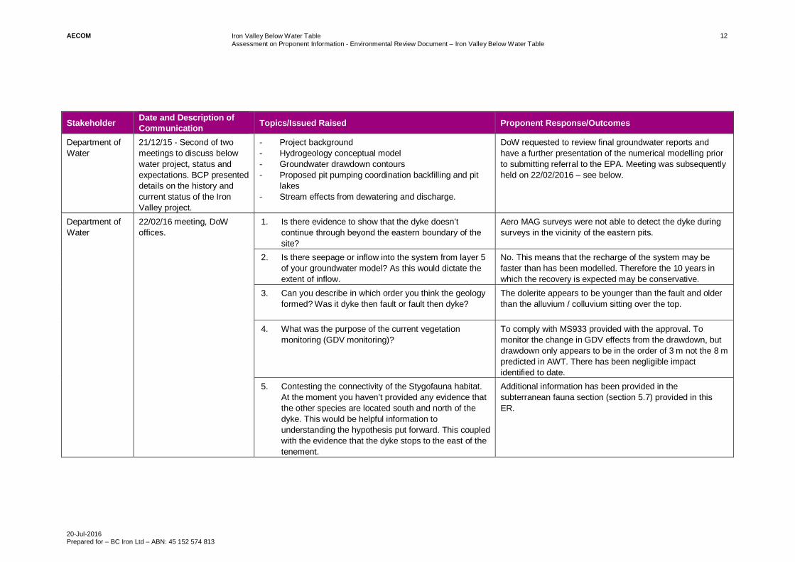
Stakeholder Date and Description ofCommunication Topics/Issued Raised Proponent Response/Outcomes
Department ofWater
21/12/15 - Second of twomeetings to discuss belowwater project, status andexpectations. BCP presenteddetails on the history andcurrent status of the IronValley project.
- Project background- Hydrogeology conceptual model- Groundwater drawdown contours- Proposed pit pumping coordination backfilling and pit
lakes- Stream effects from dewatering and discharge.
DoW requested to review final groundwater reports andhave a further presentation of the numerical modelling priorto submitting referral to the EPA. Meeting was subsequentlyheld on 22/02/2016 – see below.
Department ofWater
22/02/16 meeting, DoWoffices.
1. Is there evidence to show that the dyke doesn’tcontinue through beyond the eastern boundary of thesite?
Aero MAG surveys were not able to detect the dyke duringsurveys in the vicinity of the eastern pits.
2. Is there seepage or inflow into the system from layer 5of your groundwater model? As this would dictate theextent of inflow.
No. This means that the recharge of the system may befaster than has been modelled. Therefore the 10 years inwhich the recovery is expected may be conservative.
3. Can you describe in which order you think the geologyformed? Was it dyke then fault or fault then dyke?
The dolerite appears to be younger than the fault and olderthan the alluvium / colluvium sitting over the top.
4. What was the purpose of the current vegetationmonitoring (GDV monitoring)?
To comply with MS933 provided with the approval. Tomonitor the change in GDV effects from the drawdown, butdrawdown only appears to be in the order of 3 m not the 8 mpredicted in AWT. There has been negligible impactidentified to date.
5. Contesting the connectivity of the Stygofauna habitat.At the moment you haven’t provided any evidence thatthe other species are located south and north of thedyke. This would be helpful information tounderstanding the hypothesis put forward. This coupledwith the evidence that the dyke stops to the east of thetenement.
Additional information has been provided in thesubterranean fauna section (section 5.7) provided in thisER.

AECOM Iron Valley Below Water TableAssessment on Proponent Information - Environmental Review Document – Iron Valley Below Water Table
20-Jul-2016Prepared for – BC Iron Ltd – ABN: 45 152 574 813
13
Stakeholder Date and Description ofCommunication Topics/Issued Raised Proponent Response/Outcomes
6. The WRM report suggested that there was potential forCarbonate armouring of WWC. This doesn’t seem tohave been addressed.
Understood and additional information is provided in thisER.Carbonate armouring tends to occur when the solubility limitof Ca ions is reached. The extent of the armouring is likelyto be localised near the outfall locations, should it occur, andlikely to be disrupted during high rainfall storm or cycloneevents. Explanation now included in Section 5.6.2 and theaquatic fauna report in Appendix D1.
7. Some description of the rate of change of the watertable should be provided as this will affect thesurvivability of the GDV.
The return of water levels to equilibrium is within 10 yearsfrom ceasing pumping. Proposal design modified pumpingand it is now staged across LOM. This accounts for thecumulative effects with the RTIO discharge scenario.
8. There is no detailed design in the WRL or rockarmouring for the WRLs in the south of the site. Thereis no indication of the effect of larger flood events, andthe precautions that would be made to ensure that theWRLs didn’t end up in WWC
The details of the specific type of rock armouring to beapplied to the WRLs that are adjacent to the creek line in thesouth of the tenement will be provided in the mine closureplan and the mining proposal. In locations where scouringvelocities have the potential to occur, rock, geofabric,cement-stabilization or other scour protection measures willbe utilised, where required.
9. Need to explain why no more surface water modellingwas done. Eg. Flood modelling to PMP.
Surface water flood modelling has not been updated fromthe assessment included in 2012. The application of rockarmouring and WRL protection will be included in the miningproposal and in accordance with the guidelines for preparingmine closure plans (EPA 2015). Consideration of modellingof catchment C14 is proposed.

AECOM Iron Valley Below Water TableAssessment on Proponent Information - Environmental Review Document – Iron Valley Below Water Table
20-Jul-2016Prepared for – BC Iron Ltd – ABN: 45 152 574 813
14
Stakeholder Date and Description ofCommunication Topics/Issued Raised Proponent Response/Outcomes
Department ofWater
12/07/2016Telephone conversation andexchange of emails betweenPenny Wallace-Bell andMichael Klvac of BCP
Topic discussed related to the updated ER section related topreviously raised topics/issues:- Surface water modelling of the C14 catchment and
creek line to PMP/PMF levels- The inclusion of the C14 Creek line exclusion zone to
allow for un impeded flow pre or post closure- The inclusion of additional detail regarding the surface
water infrastructure and how they will be dealt with atclosure
- The commitment to backfill all non-flow-through pits toabove water table level prior to site closure.
Content of the revised section of the ER was issued to DoWfor comment.
CommonwealthDepartment oftheEnvironment
26/03/2015 - meeting inCanberra.
Iron Valley BWT proposal was discussed in relation tomatters of national environmental significance. Query wasraised whether discharge to WWC would have an impact onfauna / flora of national significance?
BCP to undertake relevant studies to determine whetherBWT project would impact MNES and therefore decide ifthey need to re-refer.Additional desktop study, building on the 2012 faunastudies, accounting for additional direct and indirectdisturbance to MNES species habitat has been included inAppendix D1 and Section 5.6.2 of this document.

AECOM Iron Valley Below Water TableAssessment on Proponent Information - Environmental Review Document – Iron Valley Below Water Table
20-Jul-2016Prepared for – BC Iron Ltd – ABN: 45 152 574 813
15
Stakeholder Date and Description ofCommunication Topics/Issued Raised Proponent Response/Outcomes
CommonwealthDepartment oftheEnvironment
15/12/15 - meeting inCanberra
Purpose of meeting was to show update of IV BWT proposalto demonstrate that all current EPBC approvals are relevantand still applicable to IV AWT project and BWT proposal.
- History of approvals for Iron Valley – BCI provided ahistory of the AWT and BWT approval history includingEPBC approvals.
- Approved and revised project descriptions – DoTEexpressed concerns with the EPBC approval in that itprovided approval for only the AWT component andwas not applicable to BWT. BC Iron explained that theEPBC approval document refers to the initial technicalstudy assessment documentation which was applicableto combined Iron Valley Project, inclusive of both AWTand BWT.
- Potential environmental impacts on MNES – no issueswith AWT process. BC Iron to respond to DoTE furtheroutlining the completed studies which show no furtherissues on MNES from the BWT proposal component.
Agreed outcomes – Meeting held with Shane Geddes DoTEto discuss way forward. DoTE (M. Whitting) drafted email toBC Iron outlining DoTE stance on approval to enable BCIron to officially respond and garner clarity on BWTapprovals. Outcome is for DoTE to agree that no furtherapprovals required.Follow-up of actions undertaken- DoTE (M. Whitting) drafted email to BC Iron outlining
DoTE stance on approval to enable BC Iron to officiallyrespond and garner clarity on BWT approvals.
- BC Iron officially respond to DoTE email outlining BCIron’s position on BWT approvals and provided furtherevidence / clarity that BWT component will have nofurther impact on MNES and no referral was likely tobe submitted.
- DoTE returned correspondence to BCI acknowledgingthe process already covered and the conclusionsreached.
- DoTE returned further correspondence stating thatbased on the information gathered, consultation andstudies conducted by BCI that there are unlikely to besignificant impacts to MNES, such as the Pilbara OlivePython (liasis olivaceus barroni) – listed in thevulnerable category under EPBC Act. The ComplianceSection has reviewed the information provided and hasformed the view that the proposed development isunlikely to result in significant impacts on matters ofnational environmental significance. As such, referralto the Department is not required.

AECOM Iron Valley Below Water TableAssessment on Proponent Information - Environmental Review Document – Iron Valley Below Water Table
20-Jul-2016Prepared for – BC Iron Ltd – ABN: 45 152 574 813
16
Stakeholder Date and Description ofCommunication Topics/Issued Raised Proponent Response/Outcomes
Department ofMines andPetroleum
16/09/2015 - Preliminarymeeting to discuss BWTproposal, status andexpectations. BCP presenteddetails on the history andcurrent status of the IronValley project. The DMPraised key issues asdescribed in topics raised.
Potential for Pit LakesDMP has preference for avoiding pit lakes. DMP would preferto see ‘strong evidence’ regarding the fate of pit lakes.
If backfilled, then assessment will be required on pits withregards to water quality/quantity and movement and fauna.
Sterilisation report should be included with the MiningProposal.
Proponent to further consider fate of pits.Sterilisation report will be included in Mining Proposal.Geochemistry work to be undertaken as to fate of pit lakes.
GeochemistryDMP questioned which metals may be leached as part of thewaste rock. Requested that spatial distribution of samplingboth horizontally and vertically should be made clear.
Points to be incorporated when planning samplingprogramme.
Post ClosureDMP requires post closure landscape to be clearly defined.Predictions of flooding should account for long term effectson post closure landform.
Mining proposal should provide clarity on design of TSF andhow it is integrated into the WRLs. Detail what precautionshave been undertaken in safeguarding TSF from long termerosion (rock armouring, flood protection, surface watermanagement).
Points detailed to be taken into account for mine closureplan.
Submission of Mining ProposalDMP to receive and assess mining proposal but not releasea decision until Ministerial approval has been received.DMP open to further meeting.
Comments noted. Second consultation meeting to bearranged.

AECOM Iron Valley Below Water TableAssessment on Proponent Information - Environmental Review Document – Iron Valley Below Water Table
20-Jul-2016Prepared for – BC Iron Ltd – ABN: 45 152 574 813
17
Stakeholder Date and Description ofCommunication Topics/Issued Raised Proponent Response/Outcomes
14/04/2016 – A DMP briefingwas held to discuss thestatus and intentions for theBWT Proposal MiningProposal and Mine ClosurePlan. BCP provided anoverview of BWT Proposaldetails including wastedumping, surface watermanagement, mine closureplan and completion criteriaspecifics, and safety.
DMP provided a number ofcomments in regards to theprocess and timeframes.
DMP process and timescales
a. DMP said that while there wasn’t anything stoppingthem from parallel processing, they would only do that ifthere was clear indication that no changes would occurthrough the part IV process.
b. 6 weeks is the maximum time likely to require review,and DMP would be party to the consultation in the partIV process as required by OEPA.
c. MRL suggested that the documents may be delivered inin mid-May, but end of May might be better given morepart IV certainty.
d. Level of detail – the level of detail is a key issue as itdemonstrates where and how things will come together.
e. DMP would require the appropriate level of detail forthose areas that are likely to have environmental effectsassociated with them.
f. The DMP was currently inundated with notices of intentand the new guidelines move away from thisdependency. However, the bottom line is that thedocument should demonstrate detail in areas that areconsidered by the DMP to be of high risk.
DMP queried if there was enough space to batter the slopesappropriately. A response was provided stating that this hasbeen allowed for in design at a slope of approximately 18degrees.The DMP stated it would be looking for criteria relating tolandform design, flood events. Max flood levels raised as anissue. Need to provide confidence that adequate protection isapplied to waste rock dumps for Probable Maximumprecipitation (PMP, not simply the 1:100).
DMP comments and feedback have been incorporated intothe Mining Proposal document.Additional modelling was undertaken for the PMP floodscenario for the southern-most creek line. An exclusion zonehas been incorporated into the design based on thesefindings. SWG conducted the modelling, the report islocated in Appendix B2.

AECOM Iron Valley Below Water TableAssessment on Proponent Information - Environmental Review Document – Iron Valley Below Water Table
20-Jul-2016Prepared for – BC Iron Ltd – ABN: 45 152 574 813
18
Stakeholder Date and Description ofCommunication Topics/Issued Raised Proponent Response/Outcomes
Office of theEnvironmentalProtectionAuthority
31/08/15 - Pre-referralmeeting 1. Presentationprovided background to thework at Iron Valley anddescribed the components,attributes and preliminaryenvironmental factors for theBWT proposal.
General CommentsOEPA considers factors well placed, with some overlap, suchas impacts to environment quality could fall withinrehabilitation and decommissioning. Re-injection ofgroundwater is the preferred approach for water disposal.OEPA questioned SRE’s.
It is still the intention of BCP to dispose of water to WWCand an assessment will be included in the submission toEPA.
Further work has been undertaken on SREs. The results areincluded in this ER Section 5.6, which concludes that theanimals previously detected are confirmed non-SREs.Appendix D3 presents a letter from the EPA removing thecondition for further SRE work on tenement.
Subterranean FaunaAssessment of subterranean fauna must robustly complywith EAG12 (EPA 2013c). In recent past, the contiguoushabitat rule had been applied too loosely. Technical advicegiven to the OEPA is that it should be considering habitat(pore spaces, soil moisture, geology, water) not simplygeology, as it has been caught out recently where theadequacy of the study has been insufficient to approve.
All subterranean fauna surveys to take account of EAG12(EPA 2013c) and Detailed Guidance Statement 54a. (EPA2007) The subterranean fauna assessment has beenundertaken in accordance with both of these guidancedocuments, and stated as such in the technical report(Appendix D4) and section 5.7 of ER updated.
Environmental Management PlanEMP to take account of EAG17 (EPA 2015d).
Future EMPs, as required, will be undertaken with regardsto EAG17 (EPA 2015d).
Next StepsSecond pre-referral meeting to be undertaken once waterstudies have been completed.
Consideration should be given as to approach of assessment– all aspects of BWT and AWT or limited to BWT aspects.
OEPA indicated that timescale of June 2016 unlikely.
Assessment will only be undertaken for BWT aspects.

AECOM Iron Valley Below Water TableAssessment on Proponent Information - Environmental Review Document – Iron Valley Below Water Table
20-Jul-2016Prepared for – BC Iron Ltd – ABN: 45 152 574 813
19
Stakeholder Date and Description ofCommunication Topics/Issued Raised Proponent Response/Outcomes
Office of theEnvironmentalProtectionAuthority
1/10/2015 - Letter fromOEPA. Ministerial Statement933 Condition 8-1 and 8-2.Short range endemic fauna.
BC Iron have commissioned a further assessment ofAganippe MYG086 – confirming that it should not beconsidered an SRE. This assessment has been confirmed bythe Western Australian Museum, and acknowledged by theOEPA. The OEPA have confirmed that Aganippe MYG086 isno longer considered an SRE.
Aganippe MYG086 is no longer to be considered an SRE forthe purposes of this environmental approval.
Office of theEnvironmentalProtectionAuthority
18/12/2015 - Second pre-referral meeting held afterhydrogeological modellingresults became available.
Update on the proposal based on groundwater modellingresults becoming available.
Cumulative effects – OEPA confirmed that the proposal toinclude the recently submitted PER for Yandicoogina wasgood for the purposes of cumulative impacts to thehydro/hydrogeological system in the vicinity of Iron Valley.
This is useful for understanding the wetting front as well asthe effects on riparian vegetation and GDEs in a system thatis not in a natural state. The assessment should demonstratethat the proposal will not have unacceptable impacts onWWC.
Presence of pit lakes to the north of the tenement likely.Preliminary key environmental factors likely to be:
- Hydrology and inland waters- Flora and vegetation in relation to offsets and GDEs- Subterranean fauna- And rehabilitation and decommissioning.
Cumulative impacts from RTIO’s Yandicoogina Pockets andBilliards Expansion Proposal currently under EPAassessment have been incorporated into this Iron Valleyimpact assessment, Sections 5.2, 5.3, 5.5, 5.6, 5.7

AECOM Iron Valley Below Water TableAssessment on Proponent Information - Environmental Review Document – Iron Valley Below Water Table
20-Jul-2016Prepared for – BC Iron Ltd – ABN: 45 152 574 813
20
Stakeholder Date and Description ofCommunication Topics/Issued Raised Proponent Response/Outcomes
Office of theEnvironmentalProtectionAuthority
26/02/2016 – final pre-referral meeting, held at BCPoffices.
The presentation outlined the impact assessment and itsfindings for each of the environmental factors. From this,some commentary was provided as follows:
Water was deemed to be the key issue as it sets thesecondary impacts for the sensitive receptors in the vicinityof the mine.
Demonstration of stakeholder consultation was essential asis the demonstration that EPA policy has been followed foreach of the factors.
This consultation table summarises and cross referencesthe topics raised through the consultation process andincludes BCP’s response and intention with respect to thecomment.
The document also includes relevant cross referencing andclear statements on how EPA policy has been followed inthe preparation of this ER, particularly under each of theenvironmental factors presented.
Office of theEnvironmentalProtectionAuthority
20/06/2016 - Telephoneconversation andsubsequent letter
BCP was informed that the level of assessment for theproject was API-A
Acknowledge
Office of theEnvironmentalProtectionAuthority
8/7/2016 – Telephoneconference between BCPand OEPA
The telephone conversation referred to the release of theEPA scoping guideline on 05/07/2016. In particular this callrelated to the need for BCP to provide additional detail onapplication and relevance of EPA policy to the BWTproposal. Another point of clarification sought by BCP wasthe inclusion of heritage (particularly aboriginal heritage) as akey environmental factor.
BCP undertook the policy review in accordance with theOEPA advice. The content of which appears in Appendix Hof this ER.BCP has also included the Heritage Factor in the ER inmore detail as requested by the scoping guideline.
Department ofParks andWildlife
19/02/2016 –meeting atParks and Wildlife offices
Is it the intention of the new BWT project to have a separateMS combining the expanded project
A new MS is proposed that covers the combined AWT andBWT aspects of the project, to become the Iron ValleyBelow Water Table proposal
What is the orebody – CID or BIF The orebody is Mineralised Brockman Iron Formation.
Has access of stygofauna data been acquired reviewed fromNyidinghu
No access to this data has been provided
Ensure that the proposal specifically references the EAGs Noted

AECOM Iron Valley Below Water TableAssessment on Proponent Information - Environmental Review Document – Iron Valley Below Water Table
20-Jul-2016Prepared for – BC Iron Ltd – ABN: 45 152 574 813
21
Stakeholder Date and Description ofCommunication Topics/Issued Raised Proponent Response/Outcomes
Shire of EastPilbara
30/01/15 – Meeting withmembers of the Shire of EastPilbara.
High level discussions on business and Nullagine operations. - Water usage - Currently being used in the operationsprocess i.e. Dust suppression, moisture in ore. Nothingis being discharged off site at the moment AWT.
- Opportunities for local businesses / people - MRLsbusiness model was discussed i.e. MRL undertake allwork internally, no opportunities currently available,BCI happy to bring specific capabilities to MRL ifneeded.
- BWT water discharge - BCI will commence studiessoon into water quality and usage, extraction anddischarge plans to be developed, will be doneconsistent with discussions with regulators and thetraditional owners.
- Allen Cooper suggested contact with DAFWA re: thePilbara hinterland Agricultural initiative, results due inJune 2016. https://www.agric.wa.gov.au/r4r/pilbara-hinterland-agricultural-development-initiative-phadi
- Next briefing to be provided 12 months during BWTapproval process.
Adjacent miningcompanies(FMG/Rio TintoOperations/BHP BillitonIron Ore)
07/12/15 – Meeting with RioTinto Operations
Discussions held regarding cumulative impacts andmonitoring results for groundwater dependent ecosystemassessments.Project overview provided by BC Iron and RTIO.
No specific response.
08/06/15 – Meeting withFortescue Metals Group.
Project overview for BWT discussed. Execution of agreement for BCP to access miningtenements E47/1320 and M47/1461 for monitoring of waterbores for BWT assessments.

AECOM Iron Valley Below Water TableAssessment on Proponent Information - Environmental Review Document – Iron Valley Below Water Table
20-Jul-2016Prepared for – BC Iron Ltd – ABN: 45 152 574 813
22
Stakeholder Date and Description ofCommunication Topics/Issued Raised Proponent Response/Outcomes
NyiyaparliPeople
Consultation withrepresentatives of theNyiyaparli people occurs ona regular 6 monthly basis,dates of recent meetings are14 May 2014December 2014May 2015December 2015
Provide Nyiyaparli People with an overview of the belowwater table project.
Nyiyaparli people are interested in contracting opportunitiesat the project.Nyiyaparli people would like to review the environmentalreview document and the mining proposal when available
Department ofEnvironmentRegulation
Email and telephoneconsultationJuly 2016
DER consulted in response to OEPA issues AssessmentReport 2082.Guidance sought on Hydrogeological Processes: surplusdewater discharge, in relation to the management of potentialimpacts to vegetation, fauna, and aquatic invertebratespecies resulting from the discharge to Weeli Wolli CreekDER response was that DER is not in a position to providecomment at this stage. At such time as an application issubmitted under Part V of the Environmental Protection Act1986 (EP Act), DER will carry out an assessment asnecessary. DER would not duplicate conditions imposedunder Part IV of the EP Act.
Noted
Department ofAboriginalAffairs (DAA)
12 August 2014, discussionsregarding Iron Valley BWTheritage sites and processfor section 18 applicationsand expected timing givenchanges to the assessmentprocess.
The duration of assessments has been extended due to achange in the interpretation of what constitutes andaboriginal site.
Acknowledgement of expected time delays.

AECOM Iron Valley Below Water TableAssessment on Proponent Information - Environmental Review Document – Iron Valley Below Water Table
20-Jul-2016Prepared for – BC Iron Ltd – ABN: 45 152 574 813
23
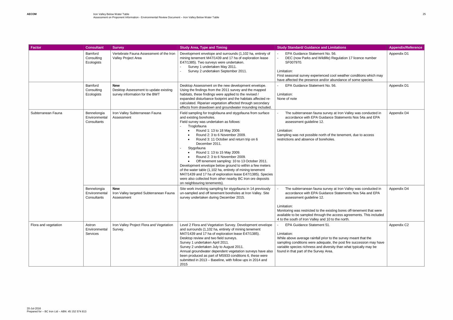
4.0 Environmental Studies and Survey EffortThis ER relies on new environmental studies as well as relevant and previously reported data and findings from the AWT project. Table 6 outlines the extent of the surveys conducted and makes the distinction of whether it is new or previously held information. Thetechnical appendices which were considered relevant from the AWT have been used and are accompanied by a covering letter from the original consulting author outlining the relevance of the report content with the BWT proposal, see appendices.Table 6 Summary of Environmental Studies and Surveys
Factor Consultant Survey Study Area, Type and Timing Study Standard/ Guidance and Limitations Appendix/Reference
Hydrological Processes / InlandWaters Environmental Quality
AQ2 NewIncrease in Groundwater Abstraction atIron Valley – Impact Assessment.Desktop Assessment dated February2015.
Desktop assessment including:- Review of historical aquifer testing- Review of groundwater monitoring data- Use of calibrated model to predict drawdowns at
specific locations- New predictions of water table decline.- Groundwater discharge options assessment.- Water balance assessment.
- Government of Western Australia – Department of Water. (2009).- Operational policy no. 5.12 – Hydrological reporting associated
with a groundwater well licence.
Limitation:None of note
Appendix B1
AQ2 NewGroundwater bore field sampling, aquiferpump testing and numerical modelling,including cumulative assessmentassociated with RTIO Yandicooginaexpansion proposal.
Fieldwork- Installation of groundwater test and monitoring wells- Permeability testing- Groundwater logging- Aquifer tests on production bores.Modelling work- Surface water management assessment- Groundwater model development and modelling of
inflows, drawdown and changes to groundwatersystem.
- Excess water assessment (volume and disposaloptions).
- Additional modelling of water management options.- Consideration of the water aspects of mine closure and
in particular assessing the implications of adoptedclosure strategies.
- ANZECC & ARMCANZ, 2004. Australian and New ZealandGuidelines for Fresh and Marine Water Quality. Australian andNew Zealand Environment Conservation Council and Agricultureand Resource Management Council of Australia and NewZealand. Canberra, ACT.
- CSIRO Land and Water, 2015. Water Resource Assessment forthe Pilbara, A report to the Government of Western Australia andindustry partners from the CSIRO Pilbara Water ResourcesAssessment, Don McFarlan (ed), 7 October 2015.
- Department of Water, 2011. Managed aquifer recharge inWestern Australia, Operational Policy 1.01, Government ofWestern Australia, January 2011.
- Department of Water, 2013a. Western Australian water in miningguideline, Water licensing delivery series report No 12,Government of Western Australia, May 2013.
- Department of Water, 2013b. Strategic policy 2.09: use of minedewatering surplus, Government of Western Australia, May 2013.
- Environmental Protection Authority (EPA), 2013. Environmentaland water assessments relating to mining and mining-relatedactivities in the Fortescue Marsh management area, Report andrecommendations of the Environmental Protection Authority,Report 1484, July 2013 (EPA 2013).
- Hydrogeologic Inc. MODHMS MODFLOW SURFACT AComprehensive Modflow Based Hydrologic Modelling System.1996.
Limitation:The groundwater flow model was developed consistent with theavailable data and includes the results of hydrogeologicalinvestigations to date. As with all models, there are limitationsassociated with data availability, conceptualisation and representationof hydrogeological processes. The model includes the known featuresof the system and is calibrated to available data. However, thepredictions are simulations only based on available information,including the current mine plan.
Appendix B1

AECOM Iron Valley Below Water TableAssessment on Proponent Information - Environmental Review Document – Iron Valley Below Water Table
20-Jul-2016Prepared for – BC Iron Ltd – ABN: 45 152 574 813
24
Factor Consultant Survey Study Area, Type and Timing Study Standard/ Guidance and Limitations Appendix/Reference
Soil WaterGroup
NewIron Valley BWT Catchment C14 –PMP/PMF Assessment
Flood assessment was conducted to PMP/PMF scenario forCatchment C14 in May 2016.Field work: NoneModelling work: to determine the depth of water flowing theC14 catchment during a PMP event, with relevance to theproject Waste Rock Landforms proposed for that part of thetenement.
Existing data and topography was used to conduct the work inaccordance with recognised methods. Methods followed include theGeneralised Short-duration Method (GSDM) and Generalised TropicalStorm Method (GTSMR) methods
Limitations: none of note
Appendix B2
Terrestrial Fauna WetlandResearch andManagement
New- Potential impacts to Aquatic
Systems literature review- Iron Valley Project. Baseline Aquatic
Fauna Survey: WWC. Wet Season2015. March 2015.
- Cumulative impact assessmentfindings
Aquatic fauna survey incorporating water quality sampling.At each site, water quality readings were taken as well assampling for aquatic fauna.Baseline fauna survey of the WWC adjacent to the Projectarea. The objectives of the baseline study were:- Sample aquatic fauna (macroinvertebrates, hyporheic
fauna, fish).- Sample water quality at sites within and adjacent to
WWC.- Identify invertebrate specimens to species level.- Analyse fauna data to assess spatial variability.- Assess the conservation status of recorded aquatic
fauna.- The baseline survey was undertaken in late March
2015.- The sampling targeted two main ecosystem types:
· Pools/riffle zones within the main channel.· Off channel pools – likely to be perched/semi-
permanent pools.
- Australian and New Zealand Guidelines for Fresh and MarineWater Quality (ANZECC/ARMCANZ 2000).
- EPA Guidance No. 20, Sampling of Short Range EndemicInvertebrate Fauna for Environmental Impact Assessment inWestern Australia (EPA 2009).
- EPA Position Statement No. 3, Terrestrial Biological Surveys asan Element of Biodiversity Protection (EPA 2002).
- EPA Guidance No. 56, Terrestrial Fauna Surveys forEnvironmental Impact Assessment in Western Australia (EPA2004c).
- Pinder et al. (2010). An arid zone awash with diversity: patterns inthe distribution of aquatic invertebrates in the Pilbara region ofWestern Australia.
- Fishers licence EXEM 2314 (Instruments of Exemption to theFish Resources Management Act 1994 for Scientific Purposes.
- DPaW licence SF010240 (reg. 17; Licence to Take fauna forScientific Purposes).
Limitation:Results based on single field sampling in March 2015 following highrainfall event, which may have influenced the species richness levelsbetween upstream (more permanent flows) and downstream. Thedownstream pools would have only recently been filled, therefore onlyproviding limited time for macroinvertebrate colonisation ofdownstream pools.
Appendix D2
DalconEnvironmental
Terrestrial Short-Range EndemicInvertebrate Fauna Survey
Development envelope and neighbouring tenements to theeast, north east and south east.- Targeted surveys with pitfall traps were undertaken
between May and June 2011.- Additional invertebrate sampling was undertaken
between 3 and 8 June 2011.
- EPA Guidance Statement 20.- Consultation with the DEC (now Parks and Wildlife).
Limitation:The timing of the survey was just outside the preferred timing as statedin EPA Guidance Statement 20. However, DEC (now Parks andWildlife) confirmed that a May to June survey would be acceptable.Additional rainfall during this period increased the yield of targetedspecies.Potential SRE (Aganippe MYG086) found but confirmation of SREstatus inconclusive without DNA sampling because specimen wasjuvenile.
Appendix D3
PhoenixEnvironmentalServices
NewThe Distribution of Aganippe ‘MYG086’(Araneae: Idiopidae) in WesternAustralia. Desktop assessment.
Desktop assessment of the SRE status of the potential SREAganippe MYG086. This involved a search of the WAMuseum databases to determine if new populations havebeen discovered. This was based on a search area of 200km from the Project area. The following works wereundertaken:- DNA sequencing on unidentified species encountered
during historical surveys.- Re-assessing the SRE status and impact on Aganippe
within the Project area.
- EPA Guidance Statement 20 and discussions with OEPAresulting in removal of AWT SRE condition.
Limitation:None of note
Appendix D
AECOM Iron Valley Below Water TableAssessment on Proponent Information - Environmental Review Document – Iron Valley Below Water Table
20-Jul-2016Prepared for – BC Iron Ltd – ABN: 45 152 574 813
25
Factor Consultant Survey Study Area, Type and Timing Study Standard/ Guidance and Limitations Appendix/Reference
BamfordConsultingEcologists
Vertebrate Fauna Assessment of the IronValley Project Area
Development envelope and surrounds (1,102 ha, entirety ofmining tenement M47/1439 and 17 ha of exploration leaseE47/1385). Two surveys were undertaken.- Survey 1 undertaken May 2011.- Survey 2 undertaken September 2011.
- EPA Guidance Statement No. 56.- DEC (now Parks and Wildlife) Regulation 17 licence number
SF007970.
Limitation:First seasonal survey experienced cool weather conditions which mayhave affected the presence and/or abundance of some species.
Appendix D1
BamfordConsultingEcologists
NewDesktop Assessment to update existingsurvey information for the BWT
Desktop Assessment on the new development envelope.Using the findings from the 2011 survey and the mappedhabitats, these findings were applied to the revised /expanded disturbance footprint and the habitats affected re-calculated. Riparian vegetation affected through secondaryeffects from drawdown and groundwater mounding included.
- EPA Guidance Statement No. 56.
Limitation:None of note
Appendix D1
Subterranean Fauna BennelongiaEnvironmentalConsultants
Iron Valley Subterranean FaunaAssessment
Field sampling for troglofauna and stygofauna from surfaceand existing boreholes.Field survey was undertaken as follows:- Troglofauna
· Round 1: 13 to 18 May 2009.· Round 2: 3 to 6 November 2009.· Round 3: 11 October and return trip on 6
December 2011.- Stygofauna
· Round 1: 13 to 15 May 2009.· Round 2: 3 to 6 November 2009.· Off tenement sampling: 10 to 13 October 2011.
Development envelope below ground to within a few metersof the water table (1,102 ha, entirety of mining tenementM47/1439 and 17 ha of exploration lease E47/1385). Specieswere also collected from other nearby BC Iron ore depositson neighbouring tenements).
- The subterranean fauna survey at Iron Valley was conducted inaccordance with EPA Guidance Statements Nos 54a and EPAassessment guideline 12.
Limitation:Sampling was not possible north of the tenement, due to accessrestrictions and absence of boreholes.
Appendix D4
BennelongiaEnvironmentalConsultants
NewIron Valley targeted Subterranean FaunaAssessment
Site work involving sampling for stygofauna in 14 previouslyun-sampled and off tenement boreholes at Iron Valley. Sitesurvey undertaken during December 2015.
- The subterranean fauna survey at Iron Valley was conducted inaccordance with EPA Guidance Statements Nos 54a and EPAassessment guideline 12.
Limitation:Monitoring was restricted to the existing bores off-tenement that wereavailable to be sampled through the access agreements. This included4 to the south of Iron Valley and 10 to the north.
Appendix D4
Flora and vegetation AstronEnvironmentalServices
Iron Valley Project Flora and VegetationSurvey.
Level 2 Flora and Vegetation Survey. Development envelopeand surrounds (1,102 ha, entirety of mining tenementM47/1439 and 17 ha of exploration lease E47/1385).Desktop review and two field surveys.Survey 1 undertaken April 2011.Survey 2 undertaken July to August 2011.Annual groundwater dependent vegetation surveys have alsobeen produced as part of MS933 conditions 6, these weresubmitted in 2013 – Baseline, with follow ups in 2014 and2015
- EPA Guidance Statement 51.
Limitation:While above average rainfall prior to the survey meant that thesampling conditions were adequate, the post fire succession may havevariable species richness and diversity than what typically may befound in that part of the Survey Area.
Appendix C2

AECOM Iron Valley Below Water TableAssessment on Proponent Information - Environmental Review Document – Iron Valley Below Water Table
20-Jul-2016Prepared for – BC Iron Ltd – ABN: 45 152 574 813
26
Factor Consultant Survey Study Area, Type and Timing Study Standard/ Guidance and Limitations Appendix/Reference
AstronEnvironmentalServices
NewIron Valley BWT Proposal GDEassessment
Desktop investigation incorporating study of aerial imageryand remote sensing analysis and ground based truthing onthe potential impact of future groundwater drawdown on GDEvegetation associated with the BWT proposal. Theassessment was targeted at three indicator speciesEucalyptus victrix, Eucalyptus camaldulensis, and Melaleucaargentea throughout an area with a 10 km radius (31,416 ha)from the tenement. The field study was conducted 22-24November 2015.
No specific standard is applicable to this desk-top and ground truthingexercise. The following outlines the methods used in the study.Aerial imagery sources, Google Earth, Landgate and BC Iron sourcedimagery was compiled and visually inspected for presence of GDV.Remote sensing analysis, using Landsat satellite imagery across anumber of spectral bands including visible, near infrared andshortwave infrared wavelengths, for the determination of ‘greeness’and ‘wetness’ ratings over time. The Normalised Difference VegetationIndex (NDVI) was used for this purpose, enabling water stress to beidentified.Ground truthing was focused on the Marillana / WWC system, andcovered 19 selected sites of interest along 25km of the combinedcreek system.
Limitation:- Coarse spatial and temporal resolution of projected groundwater
drawdown contours associated with BWT.- Exact rate of groundwater drawdown not applied to study- Natural state - depth to the water table not known- Assessment is based on Iron Valley BWT proposal discharge and
dewatering, cumulative impacts accounting for discharge intoMarillana and Weelli Wolli Creeks from adjacent mines and theeffect of discharge on GDV within the assessment area has notbeen applied
Appendix C1
Heritage URS AustraliaLtd.
Desktop searches. Undertaken August2015.
Desktop searches of Project tenement using the Departmentof Indigenous Affairs online database. Accessed 31/08/15.
- Aboriginal heritage inquiry system. Government of WesternAustralia Department of Indigenous Affairs Databases.
Limitation:None of note
Appendix E
Terra Rosa NewJune 2015archaeological and ethnographic siteidentification heritage survey conductedMay 2015
Survey of complete Mining Tenenent south of central creekline
The archaeological and ethnographic heritage survey was conductedto a site identification standard in accordance with s18 requirements,and to satisfy obligations outlined in the heritage agreement relevant tothe project. The objective of site identification surveys is to providesufficient detail to inform the DAA and ACMC’s decision on thesignificance of Aboriginal heritage values within a project footprint andany future management of those values during the development of thearea. Overviews of the procedures used during desktop and field-based research are provided below.
Ethnographic surveyavailable by request

AECOM Iron Valley Below Water TableAssessment on Proponent Information - Environmental Review Document – Iron Valley Below Water Table
20-Jul-2016Prepared for – BC Iron Ltd – ABN: 45 152 574 813
27
Factor Consultant Survey Study Area, Type and Timing Study Standard/ Guidance and Limitations Appendix/Reference
Rehabilitation and Closure SoilwaterGroup
NewIron Valley Below Water Table Project –Geochemical Investigation. Dated29/06/15.
The study area incorporates the potential waste to begenerated from the site operations and the remaininggeochemical risk. The following works were undertaken:- Review of existing data- Geochemical testing of selected samples.- Geochemical assessment of previous data,
incorporating new sampling information.
Assessment undertaken with guidance from- AMIRA (2002) ARD Test Handbook. Project 387A. Prediction and
Kinetic Control of Acid Mine Drainage. AMIRA International.Melbourne, Australia.
- ANZECC & ARMCANZ (2000) Australian and New ZealandGuidelines for Fresh and Marine Water Quality. Australian andNew Zealand Environment Conservation Council and Agricultureand Resource Management Council of Australia and NewZealand. Canberra, ACT.
- DEC (2010) Contaminated Sites Management Series:Assessment Levels for Soils, Sediment and Water, Version 4,Revision 1. February. Department of Environment andConservation, Government of Western Australia. Perth WA.
- Stone, Y., Ahern, C. R. and Blunden, B. (1998) Acid Sulfate SoilsManual 1998. Acid Sulfate Soils Advisory Committee. In.Wollongbar, NSW.
Limitation:None of note
Appendix G

AECOM Iron Valley Below Water TableAssessment on Proponent Information - Environmental Review Document – IronValley Below Water Table
20-Jul-2016Prepared for – BC Iron Ltd – ABN: 45 152 574 813
28
5.0 Assessment of Preliminary Key Environmental Factors
5.1 Preliminary Key Environmental FactorsIn 2012, BCP (then Iron Ore Holdings) submitted a Section 38 Referral to the EPA. This referral included both theabove and below water table components of the Iron Valley Project and the EPA applied an API level ofassessment. As part of that process, BCP was given a scoping guideline covering the environmental factors thatneeded to be included in the environmental review document. Subsequent to the scoping guideline beingprepared, BCP made the economic decision to submit the API for AWT only, which received approval in 2012under MS933. Although the environmental review document only addressed AWT issues, the scoping guidelinewas considered still valid for BWT, and this provided the basis of environmental factors that needed to beaddressed for this current proposal. The following applicable preliminary key environmental factors are the resultof that initial 2012 scoping guideline and subsequent discussions with the OEPA and other DMA / stakeholders:
- Hydrological processes;
- Inland waters environmental quality;
- Flora and vegetation;
- Subterranean fauna;
- Terrestrial fauna;
- Environmental offsets; and
- Rehabilitation and closure
- Heritage.
The environmental factor, the project activity which affects that factor, the environmental aspect or pathwaymechanism and the potential impacts for the BWT proposal are presented in Table 7. The impact assessment isthen further elaborated in Table 9 incorporating mitigation and management which when applied will achieve theproposed outcome. This outcome is supported by a statement explaining how the EPA’s objective applicable tothe environmental factor is considered to have been achieved. EPA policy and how the BWT proposal hasapplied the policy through its preparation of this document in relation to the above mentioned key environmentalfactors is found within Appendix H of this ER document.
BCP considers that the proposal will not result in any significant impact to the remaining environmental factorsincluded in Environmental Assessment Guideline No.8. These factors are either not applicable to the proposal orcan be adequately managed using existing regulatory mechanisms and are therefore categorised as ‘otherfactors’ and are discussed in Section 6 of this document.
Additionally, no assessment is included in this ER for matters of National Environmental Significance, becausethrough consultation with the Department of the Environment (DoTE), and the fauna studies undertaken,concluded that the incremental impact of the BWT proposal would not significantly impact the MNES speciesbecause the likely effects were considered negligible. Correspondence between BCP and DoTE acknowledgedthat a referral was not required. The fauna species have been incorporated into the vertebrate fauna section ofthis ER.Table 7 Summary of Preliminary Key Environmental Factors
EnvironmentalFactor
Project Aspect/ Activity
EnvironmentalAspect Impact
Hydrologicalprocesses / InlandWatersEnvironmentalQuality
Mine pit Dewatering aquiferfor dry miningconditions
Prolonged depletion of aquifer, resulting indepleted water supplies for existingecosystems and end users.
Water Discharge Dewatering dischargeto WWC
Increase in quantity of water within WWCextending wetting front downstream.Discharge also resulting in localisedgroundwater mounding.
TSF Infiltration from TSF. Localised groundwater mounding.

AECOM Iron Valley Below Water TableAssessment on Proponent Information - Environmental Review Document – IronValley Below Water Table
20-Jul-2016Prepared for – BC Iron Ltd – ABN: 45 152 574 813
29
EnvironmentalFactor
Project Aspect/ Activity
EnvironmentalAspect Impact
MineInfrastructure
Interception ofsurface water flowsacross the tenementto WWC.
Potential for changes to hydrological regimeand subsequent changes in water quantity todownstream environments.Potential for increased sediment loads instormwater runoff generated from site.
Inland WatersEnvironmentalQuality
Mine Pit Dewatering of aquifer. Depletion of aquifer potentially assisting theintrusion of a saline wedge and subsequentdegradation of groundwater quality from northof the tenement boundary.Some mine pits have the potential to developinto contamination sources or groundwatersinks if not backfilled.
Mine Pit Discharge of pitdewatering to WWC.
Potential change of inland water quality inWWC from the discharge of waters from IronValley operations likely to be noticeable at thewetting front. This may be in the form ofevapo-concentration of salts.
TSF Infiltration from TSF. Degradation of water quality within aquiferthrough seepage from integrated TSF cells.
Flora andVegetation
Mine Pit andInfrastructure
Direct clearance ofvegetation.
Clearance of an additional 314 ha, all of whichis considered in good to excellent vegetationcondition.
Mine Pit Dewatering of aquifer. Change in groundwater availability fordependant ecosystem (vegetation).
Mine pit waterdischarge
Discharge of water toWWC.
Potential changes to riparian vegetation fromperiods of inundation.Flourishing of vegetation in some areas due toincreased water permanency within WWCsystem.
SubterraneanFauna
Mine Pit Pit excavation anddewatering of aquifer.
Removal of habitat / organisms directly withinthe pit from direct mining excavation.Changes in habitat quantity from localisedlowering and mounding of groundwater levelsduring operations.
Terrestrial Fauna Mine PitInfrastructure
Clearance for pit andmine infrastructure.
Direct removal of habitat from clearance for pitand mine infrastructure.
Mine Pitdischarge
Discharge of excesswater into WWC.
Increased surface water and changes togroundwater levels may affect vegetationcomprising fauna habitat, within or borderingthe creek adjacent to the site as well asdownstream.
Heritage(Aboriginal)
Mine PitInfrastructure
Clearance for pit andmine infrastructure
Direct removal of heritage sites and the linksto the environment from clearance for pit andmine infrastructure.
EnvironmentalOffsets
Mine Pit andinfrastructure
Clearance of nativevegetation.
Likely residual impacts from the clearance ofgood to excellent vegetation.
Rehabilitation andClosure
Site closure Placement andconstruction of TSFand WRLs, successof rehabilitation andpit backfilling.
Potential for site not to meet its closureobjectives leading to post closure impact onthe environment to surface and groundwater,quality and re-establishment of vegetationcommunities and viable fauna habitat.

AECOM Iron Valley Below Water TableAssessment on Proponent Information - Environmental Review Document – IronValley Below Water Table
20-Jul-2016Prepared for – BC Iron Ltd – ABN: 45 152 574 813
30
5.2 Cumulative ImpactsThe EPA considers that the cumulative environmental impact from the growth in mining in the Pilbara needs to beaddressed so that conservation management actions can be implemented proactively and the costs associatedwith these are divided between all users of the region (not just the last comers). The area around FortescueMarsh, Marillana Creek and Weeli Wolli Springs/Creek is recognised for its State and Nationally significantenvironmental assets and as such it is important to assess the cumulative impacts.
There are several mining operations discharging water to the WWC, located upstream from the Iron Valleyproposal area. This has resulted in an artificial or non-natural state of baseline surface and groundwaterconditions, particularly in relation to the quantity of surface water and the groundwater levels. While the technicalstudies for this ER use the existing situation as the baseline, they also apply the assessment cumulativelyincluding one future proposal that is reasonably foreseeable and that is likely to influence the environmentalfactors that are being considered in this BWT proposal.
The RTIO Yandicoogina Pockets and Billiards Expansion Proposal is one such proposal (submitted to the EPA inNovember 2015) which is likely to influence the hydrological processes and inland waters in the vicinity of IronValley. As requested by the OEPA in the pre-referral meetings, the water, terrestrial fauna, subterranean fauna,and flora and vegetation studies for the BWT proposal have taken this RTIO proposal into account in eachrespective assessment. The EPA policy and how the BWT proposal has applied the policy through its preparationof this section is found within Appendix H of this ER document.
5.3 Hydrological Processes5.3.1 EPA Objective
Hydrological Process: to maintain the hydrological regimes of groundwater and surface water so that existingand potentials uses, including ecosystem maintenance are protected.
The EPA policy and how the BWT proposal has applied the policy through its preparation of this section is foundwithin Appendix H of this ER document
5.3.2 Context and Key Survey Findings
The proposal will require dewatering in order to advance the existing mine pits below the groundwater table. Thiswill lower the surrounding groundwater level directly adjacent to the site and in the surrounding area. AQ2 hasundertaken field drilling, permeability tests and aquifer tests to inform a numerical groundwater model whichpredicts the changes likely to occur with the Proposal’s contribution of drawdown (Appendix B1). The followingprovides a description of the likely effects on groundwater levels from dewatering and groundwater discharge. Theinformation below is sourced from the AQ2 report included in Appendix B1.
GroundwaterThe general hydrogeological setting indicates that the valley-fill successions act as the main regional aquifer. Acomponent of this aquifer comprises the mineralised zones that are known to be associated with fracturing in theBrockman Formation. The massive shales and banded iron formations within the Brockman and Weeli WolliFormations are likely to have moderate to low hydraulic conductivities, while the mineralised zones are likely tohave higher hydraulic conductivities due to fault-related fracturing and brecciation. Mineralised zones within themain orebody are generally the highest yielding and most transmissive aquifers in the proposal area. Thefollowing are the key features of the Iron Valley hydrogeology:
- A transmissive, mineralised orebody aquifer
- Saturated, leaky alluvium above the orebody
- Orebody aquifer is surrounded to the east and west by low permeability shales and BIFs
- A dyke that limits groundwater flow to the north
- Connection of the orebody to the Weekly Wolli Creek via the East Fault
- Northern extension of the orebody aquifer connected to the WWC, and
- Prevailing groundwater conditions have been altered by historical and ongoing excess water disposal fromupstream mines (RTIO and BHPB).

AECOM Iron Valley Below Water TableAssessment on Proponent Information - Environmental Review Document – IronValley Below Water Table
20-Jul-2016Prepared for – BC Iron Ltd – ABN: 45 152 574 813
31
Regionally, the direction of groundwater flow in the Proposal area is from south to north. Further drilling andtesting has indicated that there is saturated alluvium overlying the transmissive orebody, and that groundwaterflow will preferentially follow a fault line running from beneath WWC into the underlying aquifer (AQ2,Appendix B1). This is expected to deliver high recharge rates, requiring correspondingly high dewater pumpingrates.
One key feature of the hydrology of the Project area is a dolerite dyke which partly traverses the northern sectionof the orebody, with groundwater levels dropping by 30 to 40m across the dyke (a conceptual hydrogeologicalcross section is shown on Figure 4). The dyke extends from the western boundary of the tenement to the westernside of the eastern pits. Aero mag surveys have not detected the dyke beyond this point, suggesting that there iscurrently access for water movement around this eastern end of the dyke. According to Iron Valley geologicalbore logs, the valley floor is overlain by a layer of alluvial/colluvial soils approximately 30 m deep, with it thinningto about 10 m above the dyke. This provides a pathway for water to overspill the dyke during periods of elevatedrainfall, such as during cyclonic activity. The dyke will be removed by the pit excavation, resulting in a water levelrise to the north. Drawdown cones from dewatering are predicted to be elongated north south, due to lowerpermeability at the eastern and western boundaries of the ore body and the presence of the fault in the south.
Static water levels beneath the Project site have been measured as ranging from 26 to 43 metres below groundlevel (mbgl) in the north of the dolerite dyke to 6 to 18 mbgl south of the dyke.
The groundwater is currently recharged from rainfall events and discharge from other mine sites in the area. Thisdischarge of mine water from other sites has led to raised water levels in the alluvial deposits south of the site ofup to 20m.

PROJECT ID 60451502
CREATED BY RNM
APPROVED BY CJT/MJ
LAST MODIFIED 14/07/2016
Figure
T:\Jobs\42908791\DATA\FIGURES\API_IVP_BWTM_Jan2016\60451502-E002.xlsx A3 size
AECOM doe
s no
t warrant the
accurac
y or com
pleten
ess of in
form
ation disp
laye
d in this map
and
any
perso
n us
ing it do
es so at the
ir ow
n ris
k. AECOM sha
ll be
ar no resp
onsibility or liab
ility for any
errors, fau
lts, de
fects, or om
ission
s in the
inform
ation.
4
ASSESSMENT ON PROPONENT
INFORMATION
IRON VALLEY PROJECT - BELOW WATER
TABLE MINING
BC IRON
Conceptual Hydrogeological Cross-section
Data sources:AQ2 Data
Base Data: (c)
www.aecom.com
LEGEND

AECOM Iron Valley Below Water TableAssessment on Proponent Information - Environmental Review Document – IronValley Below Water Table
20-Jul-2016Prepared for – BC Iron Ltd – ABN: 45 152 574 813
33
A water disposal assessment was conducted for the volumes of mine dewatering required for the proposal. Theresult, presented in Appendix B1, is via three discharge points from on tenure locations into WWC. Thesedischarge points not only return the water back to the creek system promptly, but also provide some beneficiallocalised groundwater mounding. Discharge of water to the north of the ore body at DL5 (shown on Figure 5) hasa mounding effect on groundwater levels (Figure 6, 7, 8 and 9). The benefit of water disposal at this location isthat it is predicted to mitigate the advance of an area of elevated salinity (or saline wedge) known to exist 7 kmnorth east of the tenement boundary, likely to be associated with the Fortescue Marsh. Mounding is also likely tooccur on the eastern side of the tenement as a result of predicted water seepage from the encapsulated TSFs intozones of lower permeable geology. .
Lowering of the groundwater beneath the tenement will occur in sequence as required by the mine plan, withdischarge via three discharge points reflecting the dewatering sequence. It is expected that dewatering ofbetween 22,000 to 62,000 kilolitres per day (kL/d) will be required, depending on the mining stage. As the sitewater demand is 15,700 kL/d, there will be a water surplus which will require disposal. The drawdown anddisposal volume will vary throughout the mine life. As pits are mined out and completed, pumps will be shut offallowing a stepped groundwater recovery. A water balance summary by year is given in Table 8.Table 8 Water Balance Summary (Annual Average Rates in kL/d)
Year TotalDewatering
MaximumWaterDemand
SurplusDisposal toDL1
Disposal toDL4
Disposal toDL5
2016 62,707
15,700
47,007 15,010 15,999 15,999
2017 63,175 47,475 15,010 16,233 16,233
2018 60,166 44,466 15,010 14,728 14,728
2019 58,129 42,429 22,094 10,167 10,167
2020 22,263 6,563 0 3,282 3,282
2021 31,695 15,995 0 7,998 7,998
2022 30,305 14,605 0 7,303 7,303
2023 30,369 14,669 0 7,335 7,335
2024 42,756 27,056 0 13,528 13,528
2025 38,340 22,640 0 11,320 11,320
The predicted change of groundwater levels as a result of the Project (base case) have been modelled in terms ofa change against predicted future groundwater levels (no development) and a change against the predicted futuregroundwater levels with the development and discharge water from other mine sites. Groundwater levels areheavily influenced by disposal of water to WWC, with recharge of the aquifer occurring relatively quickly.Generally, during the mine life dewatering will lower groundwater levels around the mine site and in parts ofWWC. However, there are areas where the disposal of water to the creek will result in raising groundwater levelsin the creek to above ground level. This will be influenced by additional cumulative flow from the YandicooginaMine expansion (of the associated Pocket and Billiards pits). Effectively, this discharge from upstream willrecharge any groundwater drawdown which occurs from the dewatering within WWC. The amount of drawdown isshown on Figure 6 to 9. These figures show drawdown in relation to change against predicted future levels (nodevelopment). Negative values show where groundwater mounding will occur.
Long term, water levels are predicted to return to equilibrium levels within a ten year timespan (by 2028).However, due to the removal of the dolerite dyke, groundwater levels south of the dolerite dyke will return to levelsdeeper than the no development scenario (5 to 25m below pre-mining levels approximately) and levels north ofthe dyke shallower than the no development scenario (approximately 5 m above pre-mining level). Levels inWWC will return to pre-mining levels within two years. These changes to groundwater levels are incorporated intothe assessments on, subterranean fauna and flora and vegetation, particularly groundwater dependent vegetationand riparian vegetation adjacent to WWC.

!(
!(
!(DL5
DL4
DL1
´DATUM GDA 1994, PROJECTION MGA ZONE 50
0 500 1,000 1,500 2,000
metres
AECOM does not warrant the accuracy or completeness of information displayed in this map and any person using it does so at their own risk. AECOM shall bear no responsibility or liability for any errors, faults, defects, or omissions in the information.
1:50,000 when printed at A4
www.aecom.com
LEGEND
!(Iron Valley Discharge Locations
Where Water Enters Weeli WolliCreek
Pit
Development Envelope Boundary
Mining Tenements
Major Watercourse
Minor Watercourse
Elevation
225 - 250
251 - 300
301 - 350
351 - 400
401 - 450
451 - 500
501 - 550
551 - 600
Map Document: T:\Jobs\42908791\DATA\FIGURES\API_IVP_BWTM_Jan2016\60451502-A019_RC.mxd (rob.mcgregor) A4 size
5
Figure
Groundwater Discharge Points IntoWeeli Wolli Creek
PROJECT ID
APPROVED BY
CREATED BY
60451502
RNM
CT/MJ
LAST MODIFIED 20 JUL 2016
BC IRON
ASSESSMENT ON PROPONENT
INFORMATION
IRON VALLEY PROJECT –
BELOW WATER TABLE MINING.
Data sources:
Project Layout - BC Iron (22/12/2014)
Landgate Imagery (Aug, 2004)Predicted Contours - AQ2 (Jan,2016)
Base Data: (c) Based on information provided by andwith the permission of the Western Australian Land
Information Authority trading as Landgate (2010).
Note:C2, C3, C4, C5, N1, N2, N3,
E1, E2, S1 and S2 are sub pit labels
N2
N1 E2
E1
N3
C2
C3
C5
C4
S1
S2

5
21
-1
-2
-5
10
20
30
40
50
100
-10150
-20
-1-5
5
-10
-1
-2
2
1
-2
2
2
-5
´DATUM GDA 1994, PROJECTION MGA ZONE 50
0 500 1,000 1,500 2,000
metres
AECOM does not warrant the accuracy or completeness of information displayed in this map and any person using it does so at their own risk. AECOM shall bear no responsibility or liability for any errors, faults, defects, or omissions in the information.
1:100,000 when printed at A4
www.aecom.com
LEGEND
Development Envelope Boundary Mining Tenements
Predicted Water Level Rise (m) Predicted Water Level Fall (m)
Map Document: T:\Jobs\42908791\DATA\FIGURES\API_IVP_BWTM_Jan2016\60451502-A010_RB.mxd (rob.mcgregor) A4 size
6
Figure
Contours of PredictedDrawdown End of 2018
PROJECT ID
APPROVED BY
CREATED BY
60451502
RNM
CT/MJ
LAST MODIFIED 14 JUL 2016
BC IRON
ASSESSMENT ON PROPONENT
INFORMATION
IRON VALLEY PROJECT –
BELOW WATER TABLE MINING.
Data sources:
Project Layout - BC Iron (22/12/2014)
Landgate Imagery (Aug, 2004)Predicted Contours - AQ2 (Jan,2016)
Base Data: (c) Based on information provided by andwith the permission of the Western Australian Land
Information Authority trading as Landgate (2010).
Note:Positive drawdown represents a waterlevel
fall while a negative drawdownrepresents a water level rise.

1
2
-1
-2
-5
5
-10
10
20
30
40
50
-20
100 1
50
-1
150
-1
-5
100
5
-10
-2
-1
-2
-2
-20
-5
-5
-1
-2
-20
´DATUM GDA 1994, PROJECTION MGA ZONE 50
0 500 1,000 1,500 2,000
metres
AECOM does not warrant the accuracy or completeness of information displayed in this map and any person using it does so at their own risk. AECOM shall bear no responsibility or liability for any errors, faults, defects, or omissions in the information.
1:100,000 when printed at A4
www.aecom.com
LEGEND
Development Envelope Boundary Mining Tenements
Predicted Water Level Rise (m) Predicted Water Level Fall (m)
Map Document: T:\Jobs\42908791\DATA\FIGURES\API_IVP_BWTM_Jan2016\60451502-A011_RB.mxd (rob.mcgregor) A4 size
7
Figure
Contours of PredictedDrawdown Development andRio Tinto 2018
PROJECT ID
APPROVED BY
CREATED BY
60451502
RNM
CT/MJ
LAST MODIFIED 14 JUL 2016
BC IRON
ASSESSMENT ON PROPONENT
INFORMATION
IRON VALLEY PROJECT –
BELOW WATER TABLE MINING.
Data sources:
Project Layout - BC Iron (22/12/2014)
Landgate Imagery (Aug, 2004)Predicted Contours - AQ2 (Jan,2016)
Base Data: (c) Based on information provided by andwith the permission of the Western Australian Land
Information Authority trading as Landgate (2010).
Note:Positive drawdown represents a waterlevel
fall while a negative drawdownrepresents a water level rise.

1
2
5
-1
10
-2
20
30
40
50
-5
100
150
-10
-20
1
-2 -5
100
2
-1
-10
´DATUM GDA 1994, PROJECTION MGA ZONE 50
0 500 1,000 1,500 2,000
metres
AECOM does not warrant the accuracy or completeness of information displayed in this map and any person using it does so at their own risk. AECOM shall bear no responsibility or liability for any errors, faults, defects, or omissions in the information.
1:100,000 when printed at A4
www.aecom.com
LEGEND
Development Envelope Boundary Mining Tenements
Predicted Water Level Rise (m) Predicted Water Level Fall (m)
Map Document: T:\Jobs\42908791\DATA\FIGURES\API_IVP_BWTM_Jan2016\60451502-A012_RB.mxd (rob.mcgregor) A4 size
8
Figure
Contours of PredictedDrawdown end of 2025
PROJECT ID
APPROVED BY
CREATED BY
60451502
RNM
CT/MJ
LAST MODIFIED 14 JUL 2016
BC IRON
ASSESSMENT ON PROPONENT
INFORMATION
IRON VALLEY PROJECT –
BELOW WATER TABLE MINING.
Data sources:
Project Layout - BC Iron (22/12/2014)
Landgate Imagery (Aug, 2004)Predicted Contours - AQ2 (Jan,2016)
Base Data: (c) Based on information provided by andwith the permission of the Western Australian Land
Information Authority trading as Landgate (2010).
Note:Positive drawdown represents a waterlevel
fall while a negative drawdownrepresents a water level rise.

-1
-2
-5
1
2
5
-101
0 20
30
40
50
-20
100
150
200
-20
-1
100
-2
-5
-1
-2
-5
-1
-1
´DATUM GDA 1994, PROJECTION MGA ZONE 50
0 500 1,000 1,500 2,000
metres
AECOM does not warrant the accuracy or completeness of information displayed in this map and any person using it does so at their own risk. AECOM shall bear no responsibility or liability for any errors, faults, defects, or omissions in the information.
1:100,000 when printed at A4
www.aecom.com
LEGEND
Development Envelope Boundary Mining Tenements
Predicted Water Level Rise (m) Predicted Water Level Fall (m)
Map Document: T:\Jobs\42908791\DATA\FIGURES\API_IVP_BWTM_Jan2016\60451502-A013_RB.mxd (rob.mcgregor) A4 size
9
Figure
Contours of PredictedDrawdown end of 2025Rio Tinto Surplus Disposal Case
PROJECT ID
APPROVED BY
CREATED BY
60451502
RNM
CT/MJ
LAST MODIFIED 14 JUL 2016
BC IRON
ASSESSMENT ON PROPONENT
INFORMATION
IRON VALLEY PROJECT –
BELOW WATER TABLE MINING.
Data sources:
Project Layout - BC Iron (22/12/2014)
Landgate Imagery (Aug, 2004)Predicted Contours - AQ2 (Jan,2016)
Base Data: (c) Based on information provided by andwith the permission of the Western Australian Land
Information Authority trading as Landgate (2010).
Note:Positive drawdown represents a waterlevel
fall while a negative drawdownrepresents a water level rise.

AECOM Iron Valley Below Water TableAssessment on Proponent Information - Environmental Review Document – IronValley Below Water Table
20-Jul-2016Prepared for – BC Iron Ltd – ABN: 45 152 574 813
39
Surface WaterThe nearest significant surface water feature is the WWC, at its closest point is situated 200 m east of the northeast corner of the site (Figure 2). The WWC flows directly north from this point, away from the eastern tenementboundary. WWC is a major Pilbara drainage line which flows into the Fortescue Marsh, which in turn is anationally designated wetland system and the final receptor of all surface water flows generated in the UpperFortescue Basin.
Natural perennial flows in the WWC only occur at Weeli Wolli Spring (located approximately 25 km upstream).Artificial perennial flows occur at various locations within the Marillana and Weeli Wolli Catchments as a result ofexcess groundwater disposal from mine dewatering operations. Stream flow in the Eastern Pilbara is typicallyephemeral, being directly related to intense rainfall events usually associated with cyclonic activity or localisedthunderstorms. Surface water flow rates decay rapidly once rainfall has ceased. The drainage system upstream ofthe Fortescue Marsh has negligible base flow; stream flow infiltrates the watercourses and recharges the alluvialaquifers during these flow events.
The Marillana and WWC System receive water from a number of mining operations upstream from Iron Valley.Iron Valley is proposed to contribute to this discharge via three on tenure discharge locations (DDL1, DDL4 andDDL5 on Figure 2. These locations will enter WWC at the positions identified on Figure 5 as DL1, DL4 and DL5,located north, east and south-east of the Project area respectively. A disposal options assessment is included inAppendix B1. The options assessment concludes that re-injection of groundwater to the aquifer was not reliablebecause reinjection infrastructure was vulnerable to sustain damage during storm or cyclone events, but alsosubject to clogging making this option impractical in the long term. Due to the preferential flow pathway fromWWC into the underlying aquifer, discharge directly back to WWC system, was considered an effective rechargemechanism to the groundwater via the fault line (known as East Fault ) noted in the groundwater section (seegeological cross section on Figure 10).
Discharge water is expected to generate a surface flow in WWC (wetting front), but also contribute to groundwaterrecharge. The wetting front from discharging water from the proposal is expected to present as surface flow forapproximately 5 to 6 km downstream of the project (Figure 11). This point is approximately 40 km from theFortescue Marsh and as such during non-rainfall periods (incorporating existing mining operations in the vicinity)is not expected to have a tangible effect on the Fortescue Marsh. The majority of the flow is expected to infiltrateinto the creek bed prior to reaching the Fortescue Marsh (Appendix B1).
In addition to the existing mining operations, the RTIO Yandicoogina project is seeking approval for an expansionto the operations (known as RTIO’s Yandicoogina Pockets and Billiards Expansion Proposal), which is proposedto discharge approximately 83 GL/annum by 2017 (an increase of 30 GL/annum) (RTIO PER 2015) into WWC. Inthe absence of this Iron Valley BWT proposal, this is predicted to extend the wetting front 17 km downstream fromthe confluence of Marillana Creek with WWC. This will reach to within 7.5 km north of the Project site and meanthat surface water will be present in WWC adjacent to the Iron Valley project.
The combined increase in the wetting front from both the RTIO’s Yandicoogina Pockets and Billiards ExpansionProposal and Iron Valley BWT proposal, will be approximately 23 km downstream from the confluence ofMarillana Creek with WWC. This is approximately 20 km from Fortescue Marsh. It is expected that surface waterlevels within WWC will stabilise within two years after Iron Valley ceases discharge.
The cumulative change to the wetting front over the 10 year life of mine for Iron Valley will vary as the pumpingrates change, but there are three significant positions, presented in Figure 11. In 2016 the movement of thewetting front will reach the first position, labelled Iron Valley Wetting Front, on Figure 11. This will remain until2018 when the RTIO’s Yandicoogina Pockets and Billiards Proposal) is planned to commence discharge. This isrepresented by the wetting front position labelled Cumulative Wetting Front on Figure 11. This is expected to besustained for approximately two years, when discharge will cease from the southern discharge point DDL1. Post2020, through to 2025, the wetting front will fluctuate with changes to pumping rates as identified in Table 8 andwill experience further fluctuation with the onset of rainfall events, until all pumps at Iron valley cease. The wettingfront will then only be influenced by current existing discharge plus RTIO’s expansion operation until 2036 whenRTIOs expansion operations are predicted to cease pumping. This final wetting front is represented by thatlabelled Rio Tinto Wetting Front, on Figure 11.
This change in wetting front correspondingly provides changes to the downstream ecosystems of the creek,potentially affecting fauna habitats within the creek, the flora and vegetation assemblages, particularly withrespect to the riparian vegetation and the groundwater dependent vegetation species.

0 0.5 1 1.5 2
Kilometers
´
1:60,000 (when printed at A3)
A3 size
AECOM doe
s no
t warrant th
e ac
curacy
or co
mpletene
ss of inform
ation disp
laye
d in th
is m
ap an
d an
y pe
rson us
ing it do
es so
at the
ir own ris
k. A
ECOM shall b
ear no resp
onsibility or lia
bility for an
y errors, faults, d
efec
ts, or omission
s in the
inform
atio
n.
www.aecom.com
PROJECT ID
CREATED BY
60451502
RNM
LEGEND
Development Envelope Boundary
Pit
Dolerite Dyke
Interpreted Fault
Weeli Wolli Creek Alluvium
Weeli Wolli Creek Outwash
Scree
Scree
Channel Iron Deposit
Welli Wolli Formation
Brockman Iron Formation
DATUM GDA 1994, PROJECTION MGA ZONE 50 ASSESSMENT ON PROPONENT
INFORMATION
IRON VALLEY PROJECT –
BELOW WATER TABLE MINING.
Data sources:
Project Layout - BC Iron (22/12/2014)Risk assessment data from Astron (29/02/2016)
Landgate Imagery (Aug, 2013)
Base Data: (c) Based on information provided by andwith the permission of the Western Australian Land
Information Authority trading as Landgate (2010).
Map Document: T:\Jobs\42908791\DATA\FIGURES\API_IVP_BWTM_Jan2016\60451502-A018_RB.mxd (rob.mcgregor)
10
FigureBC IRON
Geological Cross-section(showing dyke and fault)
LAST MODIFIED
APPROVED BY CT/MJ
14 JUL 2016

!(
!(
!(
!(
!(
!(
DL5
DL4
DL1
Rio Tinto Wetting Front
Cumulative Wetting Front
Iron Valley Wetting Front
´DATUM GDA 1994, PROJECTION MGA ZONE 50
0 500 1,000 1,500 2,000
metres
AECOM does not warrant the accuracy or completeness of information displayed in this map and any person using it does so at their own risk. AECOM shall bear no responsibility or liability for any errors, faults, defects, or omissions in the information.
1:75,000 when printed at A4
www.aecom.com
LEGEND
!( Location of Wetting Fronts
!(Iron Valley Discharge Locations Where
Water Enters Weeli Wolli
Development Envelope Boundary
Mining Tenements
Map Document: T:\Jobs\42908791\DATA\FIGURES\API_IVP_BWTM_Jan2016\60451502-A014_RB.mxd (rob.mcgregor) A4 size
11
Figure
Wetting Front ExtentPROJECT ID
APPROVED BY
CREATED BY
60451502
RNM
CT/MJ
LAST MODIFIED 14 JUL 2016
BC IRON
ASSESSMENT ON PROPONENT
INFORMATION
IRON VALLEY PROJECT –
BELOW WATER TABLE MINING.
Data sources:
Project Layout - BC Iron (22/12/2014)
Landgate Imagery (Aug, 2004)Predicted Contours - AQ2 (Jan,2016)
Base Data: (c) Based on information provided by andwith the permission of the Western Australian Land
Information Authority trading as Landgate (2010).

AECOM Iron Valley Below Water TableAssessment on Proponent Information - Environmental Review Document – IronValley Below Water Table
20-Jul-2016Prepared for – BC Iron Ltd – ABN: 45 152 574 813
42
Minor Water CoursesThe project is located within a local catchment area of approximately 64 km2 (Iron Valley Catchment) which is asmall part (1.6%) of the larger Weeli Wolli catchment of 4,000 km2. Only one unnamed minor watercourse, whichtraverses the tenement just north of the southernmost pit, is likely to be affected by the proposal as the watercourse will be flanked north and south by WRLs. When this water course flows (only during limited periodsthroughout the year) it only carries a small percentage of the entire catchment. However, obstructing the flow withproject infrastructure and impeding its flow is predicted to cause upstream flooding within the tenement. As such,the proposal design has provided an exclusion zone down to a minimum of 25 m either side of this water courseto ensure disturbance is avoided. Surface water course and the exclusion zone are shown in Figure 12. Theexclusion zone requires crossing to access the southernmost pit and WRL. This crossing will be placed within thearea already approved as part of the AWT project. The design will be to provide a safe passage for site vehicleswithout interrupting water flows in the water course
The mine site itself may act to intersect water flow to WWC. However, any intercepted water during operation willbe recovered into the WWC via the dewatering then discharge. Following closure, the Project site will notrepresent a significant portion of the Weeli Wolli catchments (<1%) and will not significantly intercept surface orgroundwater flows into WWC.
Given that the BWT proposal disturbance footprint is wholly within the existing tenement boundary as AWT, theflood modelling prepared in 2012 for AWT is still considered valid. The disturbance footprint lies outside the1:100yr floodplain of WWC channel, and is not considered to be at risk of major, regional scale flooding. However,there are six smaller water courses identified as flowing through the project area some of which that may generatesignificant volumes of flood water during extreme storm events (Figure 13). Flood depths of 0.5 m during a1:100ARI is expected in catchment C13, C15 and C16 water courses, while a 1.0 – 1.5m depth is expected in themining tenement in the path of the C14 catchment see Figure 13.
Soil Water Consultants (SWC; 2016) prepared an additional desktop flooding assessment in May 2016(Appendix B2) for the C14 Catchment and as an addendum to Iron Valley BWT Hydrological Assessment Report(REF-AQ2-001-01-03). The objective of the assessment was to calculate the volume of a Probable MaximumPrecipitation (PMP) event allowing a Probable Maximum Flood (PMF) event to be modelled on the C14 creek line.The assessment identified that primary surface water flows are approximately 20-30 m wide within the middle andlower catchment areas, and are reasonably well defined throughout the length of the catchment. Creek flowsgreater than the 1:10-year peak flow (approximately 130 m3/s), have been modelled to result in overtopping of thearea between the two WRLs, resulting in flood water likely to scour the WRL batter slopes. The PMF wasestimated to be 3,640 m3/s, using Runoff-Routing Model (RORB). In the absence of adequate design, this wouldresult in the inundation of the bottom 14 m of the WRL slope.
BCP makes the commitment to appropriately rock armour the WRLs to ensure the integrity and stability of theselandforms is maintained during such flood events. Surface water management for the other water courses likely tobe intercepted by mining infrastructure are discussed in more detail in Section 2.3 of Appendix B1, and these aremade up of a combination of bunding, diversions around pits as well as allowing water to report to backfilled pits.These details will be developed into the existing surface water management plan. The following preliminarysurface water management measures are proposed:
Figure 12 shows preliminary surface water control measures for the BWT Proposal. These details will beconsidered and developed into the updated surface water management plan, prior to commencement ofoperations. The measures proposed for BWT will be consistent with those already approved with the intent onprotecting site infrastructure from flooding and ensuring that non contaminated water reports to WWC.
1. Clean stormwater runoff should be redirected around site infrastructure where possible to avoidcontamination and inundation and prevent unnecessary pumping of stormwater from mine pits. Theimplementation of diversions may be difficult in some catchment areas as many of the site catchments aredirectly intersected by mine pits in steeper areas of the site (AQ2 2016). The infrastructure areas have beenestablished and surface water management measures have already been implemented for the AWT project.These areas are not likely to require substantial changes for BWT activities and existing measures areexpected to be sufficient (AQ2 2016).
2. Currently installed reinforced bund and “spillway” to manage water flowing into the Stage 1 mine pit (southend of the Pit C) from the C15 watercourse. This was intended to allow for the controlled release of waterinto the pit, and to mitigate erosion of the pit safety bund and pit crest. Surface water entering the pit in thismanner was proposed to be pumped out and used for dust suppression or returned to a natural surfacewater channel. This spill way will be progressively moved and maintained open until closure. The part of

AECOM Iron Valley Below Water TableAssessment on Proponent Information - Environmental Review Document – IronValley Below Water Table
20-Jul-2016Prepared for – BC Iron Ltd – ABN: 45 152 574 813
43
WRL2 that will be placed to the west of Pit C will occupy much of this catchment thereby reducing the flow.The remaining flow generated post closure will be absorbed into the WRL 2 or diverted.
3. The design and high permeability of WRLs will allow infiltration of rainfall, therefore the volume of stormwaterrunoff from outer slopes should be minor. However, run-off that does occur is likely to be sediment laden,which may require management via toe drains and sediment traps, particularly along the eastern edge of theproject tenement, draining towards WWC (AQ2 2016).
4. For the proposed Stage 2 mine pit (north end of the Pit C) a diversion bund to divert the 1:100-yr peak flowwithin the northern main branches of the C16 watercourse. This branch will be integrated into the drainageaccompanying the road in that part of the tenement, while the southern branch may accommodate areinforced bund and spillway similar to that included for the central section of pit C.
5. Surface water management for the C13 catchment will initially be designed to allow floodwater to report topit S in a controlled manner. As the mine develops and along with the backfilling of Pit S, the flood water willbe diverted south around the pit at closure
6. The majority of the surface water for Catchment C14 will be directed to flow along it current path betweenthe two WRLs in the southern part of the tenement. An exclusion corridor down to a minimum of 25 m eitherside of the creek line is proposed to maintain drainage of floodwaters to WWC. Protection and surface watermanagement of WRLs adjacent to creek line will be applied using competent waste material outside theWRL to heights adequate to minimise scouring of the base of the WRLs and maintain integrity and stabilityfor a PMP/PMF post closure.
7. The southern branch of catchment C14 may be diverted north as to join the exclusion zone creek line. Thiswill be aided by the proximity of the southern part of WRL2 which will facilitate the creation of the diversionthrough its changes to local topography (due to construction of WRL).
8. Water discharge licence and application of appropriate discharge standard will be in place prior tocommencement of discharge. Activities will be subject to approval, and incorporated into the existing surfacewater management plan.
9. Current surface water drainage to manage clean water surface flows back to WWC will be maintained – thisis likely to occur through dewatering of pits during operation.
10. Majority of infrastructure areas (e.g. ROM Pad) is on raised pads to avoid inundation from surface waterflows from within the C15 and C16 watercourse catchments. Main access roads also to be raised andculverts installed at appropriate locations to facilitate the flow of clean surface water across the site.
Pit LakeFollowing cessation of mining, and water extraction, the water levels in the pits are expected to recover withinapproximately 10 years. Pit-infilling is planned to above water table for pits E and S to eliminate any potential pitlakes from forming. Pits C and N although partially back filled, will develop pit lakes post closure as they will notbe completely back filled to a level above the water table. These two pit lakes will be through-flow lakes, in whichwater flow is maintained and water is ‘refreshed’.
TSF SeepageThe TSF is likely to operate from 2016 to the end of mine life in 2025, with a constant seepage rate ofapproximately 1 to 5 L/s over the mine life. The water levels in the immediate vicinity of the TSF are constrainedto not exceed groundwater level via the use of drain cells.

Waste RockLandform 2
Drainage Line Exclusion Zone
WEEL
I WO
LLI C
REEK
Pit C
PIT S
Infrastructure Area
Waste RockLandform 2
Pit E
Waste RockLandform 2
Pit E
Waste RockLandform 1
Pit N
´DATUM GDA 1994, PROJECTION MGA ZONE 50
0 250 500 750 1,000
metres
AECOM does not warrant the accuracy or completeness of information displayed in this map and any person using it does so at their own risk. AECOM shall bear no responsibility or liability for any errors, faults, defects, or omissions in the information.
1:30,000 when printed at A4
www.aecom.com
LEGEND
Surface Water Management Point Surface Water Management Development Envelope Boundary Mining Tenements
Approved Disturbance Area (AWT) Additional Disturbance Required (BWT) Major Watercourse
Minor Watercourse
Waste Rock Landform
Pit
Infrastructure Areas
Map Document: T:\Jobs\42908791\DATA\FIGURES\API_IVP_BWTM_Jan2016\60451502-A020.mxd (rob.mcgregor) A4 size
12
Figure
BC IRON
ASSESSMENT ON PROPONENT
INFORMATION
IRON VALLEY PROJECT –
BELOW WATER TABLE MINING.
BWT Proposal Proposed SurfaceWater Infrastructure
Data sources:Project Layout - BC Iron (22/12/2014)
Surface Water Management (AQ2; Mar, 2016)
Base Data: (c) Based on information provided by andwith the permission of the Western Australian Land
Information Authority trading as Landgate (2010).
PROJECT ID
APPROVED BY
CREATED BY
60451502
RNM
CT
LAST MODIFIED 20 JUL 2016

WE
ELI W
OLLI
CR
EEK
C11
C10
C13
C16_B (50%)
C14_G (50%)
C14_
G (5
0%
)
C15_A (80%)
C16_A (50%)
C16_A (50%)
C14_H (10%)
C14_H (90%)
´DATUM GDA 1994, PROJECTION MGA ZONE 50
0 250 500 750 1,000
metres
AECOM does not warrant the accuracy or completeness of information displayed in this map and any person using it does so at their own risk. AECOM shall bear no responsibility or liability for any errors, faults, defects, or omissions in the information.
1:60,000 when printed at A4
www.aecom.com
LEGEND
Water Depth (m)
0 - 0.05
0.06 - 0.25
0.26 - 0.5
0.51 - 0.75
0.76 - 1
1.01 - 1.25
1.26 - 1.5
1.51 - 1.75
1.76 - 2
2.01 - 2.5
2.51 - 3
3.01 - 4
4.01 - 5
5.01 - 7
Modelled Area
Development Envelope Boundary
Inflow Hydrograph and percentage of the flow
Major Watercourse
Minor Watercourse
Concept Access Road
Outflow Model Boundary
Inflow Model Boundary
Waste Rock Landform
Pit
Infrastructure Areas
Map Document: T:\Jobs\42908791\DATA\FIGURES\API_IVP_BWTM_Jan2016\60451502-A004_RB.mxd (rob.mcgregor) A4 size
13
Figure
BC IRON
ASSESSMENT ON PROPONENT
INFORMATION
IRON VALLEY PROJECT –
BELOW WATER TABLE MINING.
Potential Surface WaterImpacts and Operational Riaks(100 Yr ARI Outlines)
Data sources:Project Layout - BC Iron (22/12/2014)
Base Data: (c) Based on information provided by and
with the permission of the Western Australian LandInformation Authority trading as Landgate (2010).
PROJECT ID
APPROVED BY
CREATED BY
60451502
RNM
CT/MJ
LAST MODIFIED 14 JUL 2016

AECOM Iron Valley Below Water TableAssessment on Proponent Information - Environmental Review Document – Iron Valley Below Water Table
20-Jul-2016Prepared for – BC Iron Ltd – ABN: 45 152 574 813
46
Table 9 Assessment of Impacts to Key Environmental Factors – Hydrological Process
Inherent Impact Environmental Aspect Mitigation Actions to Address Residual Impacts Proposed Regulatory Mechanism for EnsuringMitigation
Outcome to Demonstrate that Proposal Meets EPAObjectives
Hydrological processes - to maintain the hydrological regimes of groundwater and surface water so that existing and potential uses, including ecosystem maintenance are protected.
Impact 1- Lowering and mounding of water table in the
vicinity of the Iron Valley tenement.Depletion of aquifer to a maximum of260 m AHD at peak of operations causinglong term aquifer drawdown.
Aspect 1- Dewatering of aquifer to enable dry
pit excavation of ore below watertable.
- Existence of encapsulated TSF withinintegrated WRL. TSF seepageresulting in groundwater mounding.
- Water discharge points into WWCresulting in localised mounding
- Cumulative upstream increase inwater flow within WWC, contributingto water mounding within WWC.
Management Aspect 1- Monitoring of groundwater drawdown levels
with respect to predicted values.- Restricting pumping rates in accordance with
Department of Water licence based on theneeds and sensitivities of the downstreamenvironments.
- A groundwater management plan / operatingstrategy will be put in place to managedewatering with respect to GDEs identified inthe flora and vegetation and subterraneanfauna sections of this ER.
- Discharge of water to WWC in the vicinity ofthe fault line, which returns water to thegroundwater system.
- Groundwater monitoring of groundwater levelsand groundwater quality in the vicinity ofpredicted mounding, consistent with monitoringcurrently undertaken for AWT. Thegroundwater mounding is likely to mitigatesome of the effects of dewatering.
Regulation of Aspect 1- Subject to approval, a new ministerial
statement for the Project with specifieddischarge volumes and pumping rates.
- Department of Water dewatering licence.- Groundwater management plan / operating
strategy.- As part of the AWT Project, under MS 933,
the Proponent is committed to monitoringgroundwater in the vicinity of the easternWRL and would be maintained for the BWTproposal.
Outcome:Development of the proposal requires high volumes ofwater to be extracted and disposed of given the highconnectivity along a fault line to the regional aquifer.The connectivity between the WWC system and thegroundwater will be retained not only by the proposalsown discharge of water into the system, but also therecharge from the progressively increased surfacewater flowing in WWC due to the mining activitiesupstreamThe outcome from this scenario will result in changes ingroundwater levels over time, which will affectgroundwater dependent vegetation and subterraneanfauna.The changes will cause the temporary reshaping ofhabitat areas for the affected receptors. However, theextent of the habitats and the connectivity betweenthem, allow for the ecosystems to be maintainedthrough operations and return with equilibrium ofgroundwater levels (expected within 10yrs afterpumping ceases).
Impact 2- Potential for changes to hydrological regime
through changes in the position of thewetting front and the subsequent effects ondownstream receptors, aquatic fauna andflora and vegetation (riparian vegetation andgroundwater dependent species).
Aspect 2- Discharge of 17 GL/annum of
groundwater into WWC.
Management Aspect 2- Monitored discharge volumes in accordance
with discharge detailed in Table 8 (quantity) tobe complied with.
- Dewatering and discharge management plan /operating strategy to be put in place toincorporate specific receptor indicators locateddownstream.
Regulation of Aspect 2- Water discharge licence and application of
appropriate discharge standard.- Subject to approval, a management based
conditional environmental management planwill be developed.
Outcome:From the commencement of pumping, to its cessation,each phase may modify the receiving environment,through changing the location of the wetting front.However each phase will sustain the broader riparianecosystems allowing them to return to equilibrium withwater levels at the end of LOM thereby maintaining thehydrological regimes of groundwater and surface waterso that existing and potential uses, includingecosystem maintenance are protected.
Impact 3- Interception of surface water flows to WWC.
Potential for changes in hydrological regimeto downstream environment.
Aspect 3- Expansion of mine pits and
infrastructure.
Management Aspect 3- Maintain: Current surface water drainage to
manage clean water surface flows back toWWC – this is likely to occur throughdewatering of pits during operation.
- Avoid: Exclusion area of down to a minimum of25m to be maintained either side of the minorsurface water course in the southern part ofthe Project area so that flows are not inhibited.
- Rock armouring at the bases of the WRLsadjacent to creekline will be applied at heightsadequate to maintain integrity and stability ofthe WRLs post closure of Iron Valley, beingdeveloped as part of Mining Proposal andmine closure plan.
- Site surface water management plan toincorporate proposed mechanisms forsustainable water management.
Regulation of Aspect 3- As part of the AWT Project, under MS 933,
the Proponent is committed to managingdrainage related issues. The Proponent’scurrent commitments for the Project underMS 933 are detailed in Appendix A andwould be maintained for the BWT proposal.
Outcome:Flow maintained in minor southern creek linepreventing upstream flooding and disconnection toWWC.The Project site only represents a small portion (<1%)of the WWC catchment and is therefore the presenceof the project is unlikely to significantly reduce waterflow into WWC. BCP considers this outcome to meetthe EPA objective for Hydrological processes.Water management will sustain adequate surfacewater flow to WWC, whilst maintaining siteinfrastructure and managing erodibility of WRLs.
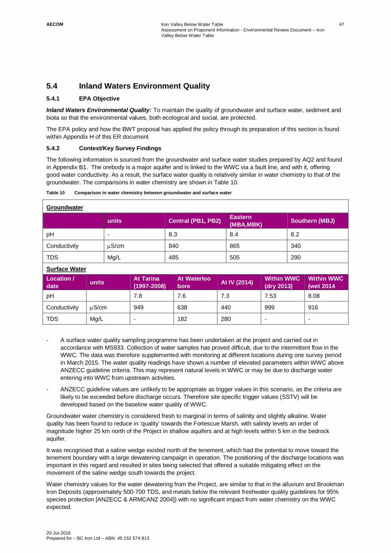
AECOM Iron Valley Below Water TableAssessment on Proponent Information - Environmental Review Document – IronValley Below Water Table
20-Jul-2016Prepared for – BC Iron Ltd – ABN: 45 152 574 813
47
5.4 Inland Waters Environment Quality5.4.1 EPA Objective
Inland Waters Environmental Quality: To maintain the quality of groundwater and surface water, sediment andbiota so that the environmental values, both ecological and social, are protected.
The EPA policy and how the BWT proposal has applied the policy through its preparation of this section is foundwithin Appendix H of this ER document
5.4.2 Context/Key Survey Findings
The following information is sourced from the groundwater and surface water studies prepared by AQ2 and foundin Appendix B1. The orebody is a major aquifer and is linked to the WWC via a fault line, and with it, offeringgood water conductivity. As a result, the surface water quality is relatively similar in water chemistry to that of thegroundwater. The comparisons in water chemistry are shown in Table 10.Table 10 Comparison in water chemistry between groundwater and surface water
Groundwater
units Central (PB1, PB2) Eastern(MBA,MBK) Southern (MBJ)
pH - 8.3 8.4 8.2
Conductivity mS/cm 840 865 340
TDS Mg/L 485 505 290
Surface WaterLocation /date units At Tarina
(1997-2008)At Waterloobore At IV (2014) Within WWC
(dry 2013)Within WWC(wet 2014
pH 7.8 7.6 7.3 7.53 8.08
Conductivity mS/cm 949 638 440 999 916
TDS Mg/L - 182 280 - -
- A surface water quality sampling programme has been undertaken at the project and carried out inaccordance with MS933. Collection of water samples has proved difficult, due to the intermittent flow in theWWC. The data was therefore supplemented with monitoring at different locations during one survey periodin March 2015. The water quality readings have shown a number of elevated parameters within WWC aboveANZECC guideline criteria. This may represent natural levels in WWC or may be due to discharge waterentering into WWC from upstream activities.
- ANZECC guideline values are unlikely to be appropriate as trigger values in this scenario, as the criteria arelikely to be exceeded before discharge occurs. Therefore site specific trigger values (SSTV) will bedeveloped based on the baseline water quality of WWC.
Groundwater water chemistry is considered fresh to marginal in terms of salinity and slightly alkaline. Waterquality has been found to reduce in ‘quality’ towards the Fortescue Marsh, with salinity levels an order ofmagnitude higher 25 km north of the Project in shallow aquifers and at high levels within 5 km in the bedrockaquifer.
It was recognised that a saline wedge existed north of the tenement, which had the potential to move toward thetenement boundary with a large dewatering campaign in operation. The positioning of the discharge locations wasimportant in this regard and resulted in sites being selected that offered a suitable mitigating effect on themovement of the saline wedge south towards the project.
Water chemistry values for the water dewatering from the Project, are similar to that in the alluvium and BrookmanIron Deposits (approximately 500-700 TDS, and metals below the relevant freshwater quality guidelines for 95%species protection [ANZECC & ARMCANZ 2004]) with no significant impact from water chemistry on the WWCexpected.
AECOM Iron Valley Below Water TableAssessment on Proponent Information - Environmental Review Document – IronValley Below Water Table
20-Jul-2016Prepared for – BC Iron Ltd – ABN: 45 152 574 813
48
The presence of salt in the water is likely to produce a zone of evapo-concentrated salt at the point where thesurface water returns underground at the wetting front. The variability of this point over the 10 years, means thatbuild up at any particular point will be temporary (greatest 5 years between 2020 and 2025). These zones ofelevated salt will be flushed out through natural rainfall events and cyclones.
Some site activities may result in suspended sediment-laden runoff during high precipitation events. However,these events will coincide with high flow events in the WWC and any run-off is likely to be in proportion to naturalsediment loads.
The geochemical assessment of the open pits (Appendix G) identified rock of circum-neutral pH, non-saline, withnegligible sulphur content and moderate to negligible buffering capacity, reaching a non-acid forming conclusion,indicating that the waste rock is not recognised as a potential source for acid mine drainage or metalliferousdrainage.
The hydrological processes assessment in Section 5.1 identified the potential for groundwater mounding beneaththe locations of the integrated TSFs. This initial categorisation of the mine material as being predominantly NAF,means that neither AMD nor MD are likely to be significant contaminant sources for the groundwater or nearbyWWC. The creek is further protected by its subsurface flanks which have very low permeability.
The mine plan design has been developed to accommodate and ameliorate early predictions of potentialenvironmental impacts. The mine plan, also severely restricted by available tenure, moved from having severalopen pit lakes at the end of mine life to only retaining two. Pits E and S will be backfilled to above the water. Aspart of the modelling, Pit E was likely to form a hypersaline pit lake sink and was therefore identified to bebackfilled to above groundwater level to prevent this occurring.

AECOM Iron Valley Below Water TableAssessment on Proponent Information - Environmental Review Document – Iron Valley Below Water Table
20-Jul-2016Prepared for – BC Iron Ltd – ABN: 45 152 574 813
49
Table 11 Assessment of Impacts to Key Environmental Factors – Inland Waters Environmental Quality
Inherent Impact Environmental Aspect Mitigation Actions to Address ResidualImpacts
Proposed Regulatory Mechanism for EnsuringMitigation
Outcome to Demonstrate that Proposal MeetsEPA Objectives
Inland Waters Environmental Quality – To maintain the quality of groundwater and surface water, sediment and biota so that the environmental values, both ecological and social, are protected.
Impact 1- Depletion of aquifer potentially assisting the
intrusion of a saline wedge and subsequentdegradation of groundwater quality fromnorth of the tenement boundary.
Aspect 1- Dewatering aquifer for pit expansion.
Management Aspect 1- The dewatering will be limited to a peak of
23 GL/annum.- Disposal of water north of the tenement
boundary (on tenure discharge point DDL5),expected to result in groundwater moundingto mitigate advancement of saline wedgepotentially exacerbated by high dewateringrates.
Regulation of Aspect 1- Subject to approval, a new ministerial
statement for the Project with a specifiedabstraction volume.
- RIWI licence amendment for groundwaterabstraction permit will be obtained fromDoW.
- Works approval for prescribed premisecategory 6, under EP Regulations 1987
Outcome: The groundwater abstraction combinedwith the selected discharge locations is notexpected to induce saline intrusions into theaquifer leading to changes to the groundwaterquality. BCP considers with the measuresproposed for this impact that the EPA object forInland Waters Environmental Quality will be met.
Impact 2- Discharge of up to 17GL/annum of
groundwater to WWC. The groundwater islikely to be of a different quality than waterwithin WWC.
Aspect 2- Dewatering discharge into WWC.
Management Aspect 2- Dewatering and discharge management plan
/ operating strategy to be put in place. Thiswill detail water quality thresholds and limitsat which management will be undertaken.Water quality thresholds will be appliedrelative to the upstream monitoring location.
- Water will be discharged into WWC at threelocations to dissipate discharge water andminimise the exacerbation of erosion of thecreek bed at the point of discharge.
Regulation of Aspect 2- Water discharge licence and application of
appropriate discharge standard.- Subject to approval, management based
condition environmental management planwill be developed.
Outcome: WWC is already an altered ecosystem,which is progressively changing from a perennialflow to a constant flow with minor seasonalfluctuations in quantity. The flow from Iron Valleymay consolidate this change in the aquaticecosystem.The water discharge criteria will be appliedrelative to upstream water quality values, as suchare not anticipated to degrade water quality whichthreaten biota or third party users downstream,thereby meeting the EPA objective for InlandWaters Environmental Quality
Impact 3- AMD or MD seepage entering groundwater
or surface water from TSF and pit voids.
Aspect 3- Storage of rock waste and tailings.
Management Aspect 3The geochemical assessment identifies potentialfor AMD or MD as very low. The TSF would beappropriately engineered to prevent significantseepage.
Regulation of Aspect 3- A works approval under the Environmental
Protection Act 1986 (category 5c) will besubmitted to the DER for approval for theconstruction and operation of the TSF’s.
Outcome: Discharge from the TSFs of sufficientquantities to contaminate groundwater andsurface water at Iron Valley are consideredunlikely due to the design controls and appropriatedrainage construction applied to this proposal.Together with the low AMD or MD potential, themonitoring and management plan currently inplace for the WRLs provides advance warning ofany potential seepage before interacting withsensitive receptors. Therefore BCP considers withthe measures proposed for this impact that theEPA object for Inland Waters EnvironmentalQuality will be met

AECOM Iron Valley Below Water TableAssessment on Proponent Information - Environmental Review Document – IronValley Below Water Table
20-Jul-2016Prepared for – BC Iron Ltd – ABN: 45 152 574 813
50
5.5 Flora and Vegetation5.5.1 EPA Objective
Flora and Vegetation: To maintain representation, diversity, viability and ecological function at the species,population and community level.
The EPA policy and how the BWT proposal has applied the policy through its preparation of this section is foundwithin Appendix H of this ER document
5.5.2 Context/Key Survey Findings
A flora and vegetation assessment was undertaken by Astron in 2012 for the proposal area as part of the AWTProject. This ER includes revised clearing area calculations based on the additional site activities andinfrastructure requirements for BWT. Astron was also requested to prepare an additional report that focussed onthe effects of groundwater changes to groundwater dependent vegetation (GDV) and riparian vegetation that maybe affected by the BWT proposal. The GDV report accompanies the 2012 report in (Appendix C1).
Flora RepresentationThe AWT flora survey was conducted across the entire Iron Valley tenement. It concluded that there were noconservation significant species, threatened ecological communities or protected ecological communities present.
Vegetation RepresentationThe vegetation is representative of two regions classified under Interim Biogeographic Regionalisation forAustralia (IBRA). These are Fortescue PIL 2 – 224.1 ha and Hamersley PIL 3 – 89.6 ha. The IBRA regions areshown on Figure 14. The vegetation sub-formations (National Vegetation Information System Level 4) foundwithin the 2012 flora and vegetation survey area fall into the following broad categories (Figure 15).
- Eucalyptus scattered low trees over Acacia scattered shrubs over Triodia hummock grasslands on rockyhillcrests and slopes.
- Acacia shrublands over Triodia hummocks and scattered tussock grasses in creeklines/drainage.
- Mixed open shrublands (Acacia, Corchorus, Grevillea and Senna) over Triodia hummock grasslands andscattered tussock grasses on plains.
Associated with these three classifications are six vegetation associations, these are listed below, identifying thetotal number of hectares of the association to be cleared:- Rocky hillslopes / hill crest vegetation association: Eucalyptus leucophloia subsp. Leucophloia scattered low
trees over scattered Grevillea wickhamii and Acacia bivenosa tall shrubs over open Triodia basedowii or T.lanigera (T. epactia) hummock grassland. Clearing for BWT 166.7 ha.
- Creeklines / drainage vegetation association: Acacia tumida and Grevillea wickhamii open shrubland oververy open Triodia epactia hummock grassland. Clearing for BWT 23.8 ha.
- Plains vegetation associations:
· Plains 1: Grevillea wickhamii scattered tall shrubs over Indigofera monophylla and Senna spp. openshrubland over Triodia epactia open to very open hummock grassland with Aristida holathera var.holathera scattered tussock grasses. Clearing for BWT 23.4 ha.
· Plains 2: Mixed Malvaceae (Corchorus, Hibiscus, Sida spp.) and Senna spp. Shrubland over Triodiaepactia open to very open hummock grassland with Aristida holathera var. holathera and *Cenchrusciliaris scattered tussock grasses. Clearing for BWT 95.9.
· Plains 3: Acacia ancistrocarpa, A. inaequilatera open to scattered shrubs over Triodia lanigera openhummock grassland with Eragrostis eriopoda scattered tussock grasses. Clearing for BWT 3.0 ha.

´DATUM GDA 1994, PROJECTION MGA ZONE 50
0 250 500 750 1,000
metres
AECOM does not warrant the accuracy or completeness of information displayed in this map and any person using it does so at their own risk. AECOM shall bear no responsibility or liability for any errors, faults, defects, or omissions in the information.
1:30,000 when printed at A4
www.aecom.com
LEGEND
Development Envelope Boundary
Mining Tenements
Total Disturbance Footprint (Approved)
Additional Disturbance Required
IBRA 7 Sub-Regions
Fortescue
Hamersley
Map Document: T:\Jobs\42908791\DATA\FIGURES\API_IVP_BWTM_Jan2016\60451502-A007_RB.mxd (rob.mcgregor) A4 size
14
Figure
IBRA Subregion MappingPROJECT ID
APPROVED BY
CREATED BY
60451502
RNM
CT/MJ
LAST MODIFIED 14 JUL 2016
BC IRON
ASSESSMENT ON PROPONENT
INFORMATION
IRON VALLEY PROJECT –
BELOW WATER TABLE MINING.
Data sources:Project Layout - BC Iron (22/12/2014)
Base Data: (c) Based on information provided by and
with the permission of the Western Australian LandInformation Authority trading as Landgate (2010).

´DATUM GDA 1994, PROJECTION MGA ZONE 50
0 250 500 750 1,000
metres
AECOM does not warrant the accuracy or completeness of information displayed in this map and any person using it does so at their own risk. AECOM shall bear no responsibility or liability for any errors, faults, defects, or omissions in the information.
1:30,000 when printed at A4
www.aecom.com
LEGEND
Development Envelope Boundary
Mining Tenements
Total Disturbance Footprint (Approved)
Additional Disturbance Required
Map Document: T:\Jobs\42908791\DATA\FIGURES\API_IVP_BWTM_Jan2016\60451502-A005_RB.mxd (rob.mcgregor) A4 size
15
Figure
Vegetation MappingPROJECT ID
APPROVED BY
CREATED BY
60451502
RNM
CT/MJ
LAST MODIFIED 14 JUL 2016
BC IRON
ASSESSMENT ON PROPONENT
INFORMATION
IRON VALLEY PROJECT –
BELOW WATER TABLE MINING.
Data sources:Project Layout - BC Iron (22/12/2014)
Base Data: (c) Based on information provided by and
with the permission of the Western Australian LandInformation Authority trading as Landgate (2010).
Plains 1 ,Grevillea wickhamii scattered tall shrubs overIndigofera monophylla and Senna spp. open shrubland over
Triodia epactia open to very open hummock grassland withAristida holathera var. holathera scattered tussock grasses
Plains 2 ,Mixed Malvaceae [Corchorus, Hibiscus, Sida] and
Senna spp. shrubland over Triodia epactia open to very openhummock grassland with Aristida holathera var. holatheraand Cenchrus ciliaris scattered tussock grasses.
Plains 3 ,Acacia [A. ancistrocarpa, A. inaequilatera] open to
scattered shrubs over Triodia lanigera open hummockgrassland with Eragrostis eriopoda scattered tussockgrasses.
Plains 4 ,Hakea lorea scattered tall shrubs over Petalostylislabicheoides scattered shrubs over Corchorus tectusscattered low shrubs over Triodia lanigera very open
hummock grassland with Aristida holathera var. holatherascattered tussock grasses.
Creek Line/ Drainage ,Acacia tumida and Grevillea wickhamii
open shrubland over very open Triodia epactia hummockgrassland
Rocky Hillslopes/Hill Crests ,Eucalyptus leucophloia subsp.leucophloia scattered low trees over scattered Grevillea
wickhamii and Acacia bivenosa tall shrubs over open Triodiabasedowii or T. lanigera [T. epactia] hummock grassland
Disturbed ,Infrastructure Yard
Disturbed ,Track

AECOM Iron Valley Below Water TableAssessment on Proponent Information - Environmental Review Document – IronValley Below Water Table
20-Jul-2016Prepared for – BC Iron Ltd – ABN: 45 152 574 813
53
Vegetation Associations – Direct Impacts from ClearingThe clearing of vegetation as part of the development of the BWT proposal, will not result in the loss of anyconservation significant species, threatened ecological communities (TEC) or protected ecological communities(PEC). Therefore direct clearing for the BWT proposal is not considered a key environmental impact excepting forthe fact that it is considered good to excellent vegetation and therefore triggers an offset for its clearing.
However the design of the project footprint has been minimised. The design has incorporated the need for anexclusion zone either side of the southern creek line, to allow for unimpeded flow and movement of faunabetween the rangelands and WWC. The design has also incorporated the need to backfilling and progressiverehabilitation, which has resulted in the need for non-permanent topsoil storage areas. The manipulation of themine plan in conjunction with these measures has restricted the clearing to 314 ha of native vegetation for theBWT mine development. The quality of this vegetation considered good to excellent. This 314 ha is in addition tothe already approved 674 ha of good to excellent condition vegetation for the AWT project.
The EPA established a position of applying a presumption against clearing of vegetation in areas where nativevegetation had already been extensively cleared (in Position Statement No. 2 (EPA 2000) and GuidanceStatement 10 (EPA 2006)). The scale used to determine the extent of vegetation types is that of the VegetationSystem-Association, which (for the Pilbara):
- Are the finest scale of mapping units used in the Comprehensive, Adequate and Representative (CAR)reserve system analysis for Western Australia (Government of Western Australia 2009); and
- Units that were mapped in the Pilbara at a scale of 1:1,000,000 by the Department of Agriculture and theDepartment of Environment and Conservation (Beard et al. 2013).
In non-constrained areas (i.e. outside urban areas), such as the BWT proposal, the presumption against clearingapplies:
- Where the total extent remaining of a regional vegetation type is below a threshold of 30% of its estimatedpre-European settlement extent or
- When clearing would result in the percentage remaining falling below the 30% threshold.
Table 12 presents the extent of clearing in relation to the remaining extent of pre-European (Beard 1975)vegetation associations within the relevant IBRA subregion classification.Table 12 Clearing of Vegetation Associations
VegetationAssociation code**
RegionalVegetationdescription
Area to becleared
Current extentremaining withinIBRA subregion*
Percentage of sub-region vegetationassociation to becleared
29 Fortescue Sparse lowwoodland, mulga(Acacia aneuraand allies),discontinuous inscattered groups
224.1 ha 893,221 ha 0.025%
82 Hamersley Hummockgrasslands, lowtree steppe;snappy gum(Eucalyptusleucophloia overTriodia wiseana
89.6 ha 2,165,235 ha 0.004%
* Government of Western Australia 2014**Beard 1975
Groundwater Dependent VegetationThe most influential aspect of the BWT project is the extent of dewatering and the discharge of this water toWWC. Astron has undertaken an assessment of GDV in an area of 10 km radius from the centre of the tenement(Appendix C1). For this study, Astron used Eucalyptus victrix, Eucalyptus camaldulensis (facultativephreatophytes) and Melaleuca argentea (obligate phreatophyte) as key indicator species for their potential

AECOM Iron Valley Below Water TableAssessment on Proponent Information - Environmental Review Document – IronValley Below Water Table
20-Jul-2016Prepared for – BC Iron Ltd – ABN: 45 152 574 813
54
groundwater dependence and known presence in the area. Using a combination of three different methods: visualinspection of aerial imagery, analysis of multispectral satellite (Landsat) imagery and on-ground reconnaissancethis study inspected GDV along 25 km of the Marillana/WWC System. This approach tends to focus on vegetationof ‘good health’, as this is what returns the best ‘green-ness’ indexing using the multispectral satellite imagery. Assuch the GDV in the assessment is regarded to be in good health, this was ground truthed during the field walk-over, thereby offering a conservative assessment.
The findings of the study showed that within the 10 km radius 31,416 ha, the total area containing GDV was2,284 ha. GDV was found along the entire inspected length of the creek system, with little variability in vegetationhealth, ranging mostly along the creek, but at times up to 1.5 km from the creek bed, within the flood plain.
The range in abundance varied between the dryer northern parts of Weeli Wolli, compared to greater extent ofnumbers in the southern reaches of Weeli Wolli and Marillana Creeks. The following observations were made:
- The southern section of the system is clearly affected by current level of discharge from nearby miningoperations. Southern areas were wetter and more highly productive, supporting dense stands of the triggerspecies.
- Areas north of the tenement are not influenced by mine discharge currently and were observed to be drierwith less abundance of the indicator species. This suggests that the southern areas are likely to supportvegetation that is both discharge and groundwater dependent.
Vegetation Associations – Indirect Impacts from Water DischargeFrom the desktop and field study, a risk assessment was applied to the areas where GDV was found, and theseareas mapped, based on the relative changes to groundwater levels and the presence of surface water. The riskassessment methodology was applied to both the base case (BWT in isolation plus the current level of upstreamdischarge) as well as the cumulative scenario of additional upstream water discharge from RTIO’s YandicooginaPockets and Billiards Expansion Proposal, currently under EPA assessment. The details of the risk assessmentare provided in Appendix C1, the findings of the risk assessment were mapped as presented in Figure 16. Therisk assessment arrived at the following conclusions.
- The base case scenario identified approximately 591 ha (23%) to be at a high risk (50 to 100%) probabilityof decline. Figure 16 shows the majority of the high risk area located within approximately 6 km of the WeeliWolli / Marillana confluence.
- Surface water discharge from BWT was likely to pose a moderate risk (10 – 50% probability of decline)immediately downstream of the discharge points, with no risk beyond the projected Iron Valley wetting front.
- The cumulative scenario, incorporating BWT with the additional discharge from RTIO Pockets and Billiardsexpansion, concludes with a similar proportion of high risk of decline (583 ha, 23%) though the distribution ispushed further north, up to approximately 14 km north of the confluence of the two creeks and approximately2 km north of the discharge location DDL5.
- The results suggest that the cumulative impacts could mitigate potential negative impacts of drawdown fromthe BWT project along the southern portion of the WWC system, but push them further north, which could beeither positive in some areas and negative in others, depending on species, spatial distribution of vegetationand tolerance to inundation and water logging.
- Groundwater modelling for BWT showed relatively rapid recovery of the groundwater levels to equilibriumwithin 10 years of the pumps stopping. It is likely that there will then follow a period of readaptation for theGDV which again may cause some water stress on the vegetation. The modifications to the mine plandesign have enabled a staged reduction in discharge to the WWC. This in turn will limit the abruptness of thechange in water availability downstream.
- Given the extent of significant GDV in the vicinity of the project, and the apparent good health of upstreampopulations (already receiving additional water from mine discharge) and downstream populations, recoveryof the ecosystem is expected, particularly if management measures such as staged discharge reduction areimplemented.

G
G
G
G
#*
DL5
DL4
RTIO DL
Iron Valley Wetting Front
Confluence
0 1 2 3 4
Kilometers
´
1:100,000 (when printed at A3)
A3 size
AECOM doe
s no
t warrant th
e ac
curacy
or co
mpletene
ss of inform
ation disp
laye
d in th
is m
ap an
d an
y pe
rson us
ing it do
es so
at the
ir own ris
k. A
ECOM shall b
ear no resp
onsibility or lia
bility for an
y errors, faults, d
efec
ts, or omission
s in the
inform
atio
n.
www.aecom.com
PROJECT ID
CREATED BY
42908791
RNM
LEGEND
#* Confluence point
G Discharge location point - Base
Watercourse centreline
GDV risk area
Watercourse (200m buffer)
Development Envelope Boundary
Mining Tenements
Risk Levels
High
Moderate
Low
Negligible
DATUM GDA 1994, PROJECTION MGA ZONE 50 ASSESSMENT ON PROPONENT
INFORMATION
IRON VALLEY PROJECT –
BELOW WATER TABLE MINING.
Data sources:
Project Layout - BC Iron (22/12/2014)Risk assessment data from Astron (29/02/2016)
Landgate Imagery (Aug, 2013)
Base Data: (c) Based on information provided by andwith the permission of the Western Australian Land
Information Authority trading as Landgate (2010).
Map Document: T:\Jobs\42908791\DATA\FIGURES\API_IVP_BWTM_Jan2016\60451502-A016_RB.mxd (rob.mcgregor)
16
FigureBC IRON
Groundwater Dependent VegetationDistribution - Risk Assessment
LAST MODIFIED
APPROVED BY CT/MJ
14 JUL 2016
G
G
G
G
#*
DL5
DL4
RTIO DL
Cumulative Wetting Front
Confluence
Iron Valley Project Impact - In Isolation Cumulative Impact - Rio Tinto Proposed Mine

AECOM Iron Valley Below Water TableAssessment on Proponent Information - Environmental Review Document – Iron Valley Below Water Table
20-Jul-2016Prepared for – BC Iron Ltd – ABN: 45 152 574 813
56
Table 13 Assessment of Impacts to Key Environmental Factors – Flora and Vegetation
Inherent Impact Environmental Aspect Mitigation Actions to Address Residual Impacts Proposed Regulatory Mechanism for EnsuringMitigation
Outcome to Demonstrate that Proposal MeetsEPA Objectives
Flora and Vegetation – To maintain representation, diversity, viability and ecological function at the species, population and community level
Impact 1- Clearing of an additional 314 ha of
native vegetation of good to excellentcondition.
Aspect 1- Clearing of native vegetation
- Application of an offset to account for the residual good toexcellent vegetation that will be cleared as part of the BWTproject.
- The Project footprint has been adjusted to minimise clearance ofgood to excellent vegetation. This has been adjusted based onmaintaining an exclusion zone along the southern creek line andthe modification of the mine plan to backfill pits, integrate theTSF to the WRLs and progressively rehabilitate, therebyreducing the space required for clearing.
- Existing construction and operational management plans tomanage impacts. Key actions include:· Management procedures in place to prevent accidental
clearing.· Progressive clearing and rehabilitation will be undertaken.· Vehicles and machinery will only use designated
tracks/roads.
Regulation of Aspect 1- Subject to approval, a ministerial statement
for the Project with a specified clearing limit,a defined Proposal Area and a conditionrelating to Offsets and Rehabilitation.
Outcome: No TECs, PECs, or Threatened floraspecies will be affected by the Proposal as nonehave been recorded within the defined Proposalarea.Progressive rehabilitation will be undertakenwhere possible and landforms rehabilitated in thelong term.
The residual, unavoidable impacts on clearance ofgood to excellent vegetation from this Proposalwill be addressed via the provision of an offset inaccordance with EPA requirements. Theunavoidable clearing of 314 ha is below the 30%threshold as per position statement No.2. Despitethis clearing the vegetation remaining is expectedto maintain representation, diversity, viability andecological function at the species, population andcommunity level, because the vegetationcommunities within the site are widely representedoutside the proposed clearing area, and meet theEPA objective for flora and vegetation.
Impact 2- Groundwater table draw down and
mounding affecting groundwaterdependent vegetation with theinfluence of the extension of thepermanent water wetting front inWWC. Likely to result in decline (highrisk of decline; 50 – 100% probabilityof decline) of approximately 23%(590 ha) of identified GDV andriparian vegetation within 10 kmradius of the tenement boundary.
Aspect 2- Dewatering for development of
the mine pit.- Discharge of 17 GL/year into
WWC.
Management Aspect 2Groundwater- Monitoring of groundwater drawdown levels and the condition
assessment of groundwater dependent vegetation. As percurrent management and reporting.
- The current use of groundwater by many of the species isunknown, therefore future monitoring will ascertain if degradationis occurring.
- Dewatering discharge will be diverted to WWC at three keylocations, to enable rapid return of water to the system. Thisdischarge is considered to ameliorate the effects of lowering ofgroundwater.
- The fluctuation of the position of the wetting front throughmodification and changes to pumping rates over the life of mine,means there will not be a sustained position of the wetting front>5yrs during the 10 year mine life.
Discharge- Dewatering and discharge management plan to be put in place
to incorporate specific receptor indicators located downstream.- Monitoring of water quantity and quality discharged from site
included in plan.- Monitoring of water parameters upstream to be used as
reference for meeting criteria.- Riparian vegetation health to also be included in management
plan.- Monitored discharge volumes in accordance with Table 8
(quantity) to be complied with.
Regulation of Aspect 2- A GDV management plan is currently in
place for the AWT project. This willexpanded to include the BWT impact area.This will detail future monitoring andmanagement objectives (managementbased conditional EMP).
- Water discharge licence and application ofappropriate discharge standard.
- Subject to approval, a dewater anddischarge management plan / operatingstrategy or a conditional environmentalmanagement plan will be developed.
Outcome: The potential impacts on GDV havebeen phrased in terms of potential risk. 590 ha(23% of GDV within a 10km radius) have beenidentified as at a high risk of decline. The locationof the impact is dependent on whether the projectexists cumulatively with RTIO’s expansion project,but the extent of risk is similar.Areas upstream already affected by additionalwater in WWC has shown signs of flourishing.GDV exists extensively in the WWC and MarillanaCreek system. Impacts are likely to affect someareas of the system more than others, and it islikely that there will be some loss of individualtrees as a result of the proposal. The loss is likelyto be temporary, due to the fluctuations of thegroundwater level and the movement of thewetting front over time (proportional to pumpingrates).With the rapid recovery of the groundwater levels(within 10 years of stopping the pumps) theindicator species and ecosystem is expected torecover as groundwater levels and permanency ofwater in the creek system returns to natural pre-mining levels.
It is under these conditions that BCP considersthat the indicator species will be able to maintainrepresentation, diversity, viability and ecologicalfunction at the species, population and communitylevel and will meet the EPA objective.

AECOM Iron Valley Below Water TableAssessment on Proponent Information - Environmental Review Document – Iron Valley Below Water Table
20-Jul-2016Prepared for – BC Iron Ltd – ABN: 45 152 574 813
57
Inherent Impact Environmental Aspect Mitigation Actions to Address Residual Impacts Proposed Regulatory Mechanism for EnsuringMitigation
Outcome to Demonstrate that Proposal MeetsEPA Objectives
Impact 3- Spread of existing weed and/or
introduction of new weeds.
Aspect 3- Vehicle and earth movements- Visitors to site (animals and
people)
Management Aspect 3- Current weed mapping and routine weed inspections to continue- Clearing will be undertaken in weed free areas prior to infested
areas where practicable to limit the opportunity to spread.- Weed, disease and pest hygiene requirements as per current
practice including vehicle wash down and inspections.- Environmental inductions will be conducted with the workforce to
include the identification of weed species, hygiene practices toprevent introduction and spread of weeds and the reporting ofinfestation sites.
Regulation of Aspect 3- Weed management will be in accordance
with the requirements of the Agriculture andRelated Resources Protection Act 1976.
- Environmental Protection Act 1986- Environmental Protection and Biodiversity
Conservation Act 1999- Environmental Weed Strategy for Western
Australia (CALM, 1999)- Conservation and Land Management Act
1984- Conditions 7.3 and 7.4 of MS933.
Outcome: Continuing to implement the currentweed management plan and annual weedmonitoring as per MS933 at Iron Valley it isconsidered that weeds will not significantly impactnative flora and vegetation and will therefore meetthe EPA objective for flora and vegetation.
Impact 4Ceasing Discharge of GroundwaterThe potential impact is that vegetationsupported by the groundwater dischargewill be degraded over time, removingfauna habitat and vegetation once thegroundwater discharge has ceased:- Degradation of fauna habitat along
WWC.- Degradation of vegetation and flora
along WWC.- Degradation of ecosystem in WWC
Aspect 4- Groundwater discharge during
operations
Management Aspect 4- Water discharge will be gradually reduced during the end of
operations to minimise the effects of abruptly ceasing WWCsurface flow.
- The groundwater discharge will be undertaken over a number ofdischarge points, dispersing flow and potential impacts.
- There will be continued flow in WWC from other miningoperations upstream after Iron Valley ceases production.
Regulation of Aspect 4- Conditional EMP to maintain pumping rates
within the volumes predicted.
Outcome: Ceasing the discharge at BWT proposalis likely to have some effect on the ecosystemwithin WWC. At that stage the groundwater willstart to return to pre-proposal state, and thesurface water expression will do as well. However,the presence of the wetting front will be dependenton the mining operations upstream. The extensivenature of the GDV up and downstream, meansthat the return the ecosystem to pre-miningscenario is expected. The ceasing of waterdischarge in this manner is therefore likely toecologically sustain the return of GDV into closureto the areas affected by the proposal duringoperation, thereby in the long term, meeting theEPA objective.

AECOM Iron Valley Below Water TableAssessment on Proponent Information - Environmental Review Document – IronValley Below Water Table
20-Jul-2016Prepared for – BC Iron Ltd – ABN: 45 152 574 813
58
5.6 Terrestrial Fauna5.6.1 EPA Objective
Terrestrial Fauna: To maintain representation, diversity, viability and ecological function at the species,population and assemblage level.
The EPA policy and how the BWT proposal has applied the policy through its preparation of this section is foundwithin Appendix H of this ER document
5.6.2 Context/Key Survey Findings
The terrestrial fauna technical studies are included in Appendix D of this document. It includes the originalBamford consulting Ecologists’ vertebrate fauna report from the original submission from 2012 with a coveringletter explaining the additional impact from the BWT proposal. Appendix D also includes the aquatic fauna reportproduced by Wetland Resource Management (WRM) and the original and revised subterranean fauna report,prepared by Bennelongia. The Short range endemic study report by Dalcon Environmental is includedaccompanied by a report from Phoenix and a covering letter from the EPA which removes the current SREMinisterial Statement condition and the need for further SRE studies within the tenement boundary. This sectionbriefly outlines the findings of each of the studies.
Conservation Significant Species – Listed under the WC Act and EPBC ActThe pre-site desktop study identified the potential for 21 conservation significant species to occur in the proposalarea, a field survey was undertaken for the Project in 2011, and reviewed and updated to take account of theBWT in 2015. Four current conservation significant species were recorded from field surveys:- Rainbow Bee-eater (migratory under EPBC act).
- Australian Bustard (Priority 4 under the WC Act).
- Western-pebble-mound mouse (Priority 4 under the WC Act).
- Rufous-crowned Emu-wren (not listed but considered locally significant).
One species previously considered to occur in the area, Crest-tailed Mulgara Dasycercus cristicauda, wasincluded as a precaution in the AWT assessment. The incidence of this species has since been discounted fromthe region, with the sightings to be that of the non-listed Brush-tailed mulgara Dasycercus blythi.
Fauna Habitat – Direct Impacts from Site ClearingThe location of these species found within the study area is presented in Figure 17. The migratory Rainbow Bee-eater was recorded throughout the study area, but no nests were found. This species breeds in a wide variety ofsandy habitats across much of the state, in the north Kimberly, on the swan coastal plain and in the south west. Itis a widespread species that is opportunistic in its use of habitat. The Rainbow Bee-eater was observed within theBoolgeeda land system of the project area which is recognised to exist extensively within 15 km from the projectboundary. Clearing of suitable habitat within the Boolgeeda land system will be less than that cleared for AWT,additional percentage clearing of habitat <2.38%.
The Australian Bustard was recorded with tracks over much of the project area The Australian bustard wasrecorded within the Boolgeeda land system of the project area which is recognised to exist extensively within15 km from the project boundary. Clearing of suitable habitat within the Boolgeeda land system will be less thanthat cleared for AWT, additional percentage clearing of habitat <3.82%.
Western Pebble mound mice are active within the area, and old activity from the Pebble mound mouse wasrecorded to the southwest corner of the site (outside the proposed clearing footprint) while active mounds werelocated nearby outside of the tenement boundary. The Western Pebble mound mouse was found within theNewman land system which is recognised to exist extensively within 15 km from the project boundary. Clearing ofsuitable habitat within the Newman land system will be less than that cleared for AWT, additional percentageclearing of habitat <0.7%.
The Rufous Crowned Emu Wren was found nearby but outside the tenement boundary within the Boolgeeda landsystem which is recognised to exist extensively within 15 km from the project boundary. Clearing of suitablehabitat within the Boolgeeda land system will be less than that cleared for AWT, additional percentage clearing ofhabitat <3.82 %.

!
!
!
"!X#
X
!
´DATUM GDA 1994, PROJECTION MGA ZONE 50
0 250 500 750 1,000
metres
AECOM does not warrant the accuracy or completeness of information displayed in this map and any person using it does so at their own risk. AECOM shall bear no responsibility or liability for any errors, faults, defects, or omissions in the information.
1:30,000 when printed at A4
www.aecom.com
LEGEND
Development Envelope Boundary
Mining Tenements
Total Disturbance Footprint (Approved)
Additional Disturbance Required
Map Document: T:\Jobs\42908791\DATA\FIGURES\API_IVP_BWTM_Jan2016\60451502-A006_RB.mxd (rob.mcgregor) A4 size
17
Figure
Conservation Significant VertebrateFauna in the Project Area
PROJECT ID
APPROVED BY
CREATED BY
60451502
RNM
CT/MJ
LAST MODIFIED 14 JUL 2016
Conservation Significant Species (Bamford, 2012)
Australian Bustard, Recorded with tracks over much of
project area
! Crest-tailed Mulgara, Active Burrow
!Rainbow Bee-eater, Recorded throughout project area.
Several pairs active regularly near camp
! Rufous-crowned Emu-wren, On track near Mulgara burrow
! Western Pebble-mound Mouse, Active
# Western Pebble-mound Mouse, Inactive
" Western Pebble-mound Mouse, Inactive and very old
X Western Pebble-mound Mouse, Recently Active
Plains 1 ,Grevillea wickhamii scattered tall shrubs over
Indigofera monophylla and Senna spp. open shrubland overTriodia epactia open to very open hummock grassland withAristida holathera var. holathera scattered tussock grasses
Plains 2 ,Mixed Malvaceae [Corchorus, Hibiscus, Sida] and
Senna spp. shrubland over Triodia epactia open to very openhummock grassland with Aristida holathera var. holatheraand Cenchrus ciliaris scattered tussock grasses.
Plains 3 ,Acacia [A. ancistrocarpa, A. inaequilatera] open toscattered shrubs over Triodia lanigera open hummockgrassland with Eragrostis eriopoda scattered tussock
grasses.
Plains 4 ,Hakea lorea scattered tall shrubs over Petalostylislabicheoides scattered shrubs over Corchorus tectusscattered low shrubs over Triodia lanigera very open
hummock grassland with Aristida holathera var. holatherascattered tussock grasses.
Creek Line/ Drainage ,Acacia tumida and Grevillea wickhamii
open shrubland over very open Triodia epactia hummockgrassland
Rocky Hillslopes/Hill Crests ,Eucalyptus leucophloia subsp.
leucophloia scattered low trees over scattered Grevilleawickhamii and Acacia bivenosa tall shrubs over open Triodiabasedowii or T. lanigera [T. epactia] hummock grassland
Disturbed ,Infrastructure Yard
Disturbed ,Track
BC IRON
ASSESSMENT ON PROPONENT
INFORMATION
IRON VALLEY PROJECT –
BELOW WATER TABLE MINING.
Data sources:Project Layout - BC Iron (22/12/2014)
Base Data: (c) Based on information provided by and
with the permission of the Western Australian LandInformation Authority trading as Landgate (2010).

AECOM Iron Valley Below Water TableAssessment on Proponent Information - Environmental Review Document – IronValley Below Water Table
20-Jul-2016Prepared for – BC Iron Ltd – ABN: 45 152 574 813
60
These species recorded during the survey are not considered to be significantly affected by the BWT proposalwith the additional clearing of approximately 314 ha, as their habitat is found extensively outside the tenementboundary (Appendix D1).
In the AWT assessment, a further two species listed under the Environmental Protection and BiodiversityConservation Act 1999 (EPBC Act) (Northern Quoll, Pilbara Olive Python) were included and discussed, but notrecorded during the survey. Although some suitable habitat may exist, the Northern Quoll was not recorded inrepeated surveys in the general region and has only been found very infrequently in the general area.
The Pilbara Olive Python is likely to be resident in the area. Both the Olive Python and the Northern Quoll willhave favourable habitat type removed as part of the BWT proposal. Their habitat types are linked to land systems,particularly the Newman Land system. The clearing will include 215 ha that represents vegetation within theNewman land system. This equates to 1.2% of proportional impact upon the Newman Land System within a 15km radius of the site.
It is likely that the Pilbara Olive Python relies not only on the vegetation found within the Newman land system butalso on the River Land Systems. No River Land Systems exist within the tenement boundary, but it is foundextensively within 15 km from the site boundary. Therefore, including this River Land Systems as suitable habitatoutside the tenement boundary in addition to the Newman Land System described above, the extent of clearingresults in a very low proportional impact for Pilbara Olive Python habitat of 1.07%. Where the proposal site islocated, it is likely that the Pilbara Olive Python uses minor water courses to access WWC from the elevatedareas to the west. As such the creek line located to the south of the project is likely to already provide this access.The application of an exclusion zone down to 25m either side of the creek centreline is a design measure that willnot only maintain water flow from the elevated topography, but also provide a corridor for east west fauna access.
The assemblage of vertebrate fauna expected to occur within the project area reflects the community structure ofthe Pilbara Region. The fauna assemblage is not considered unique, with the environment widespread in theregion, and the assemblage considered typical of the region. In terms of completeness, the overall assemblage islacking a few of the usual mammals but is otherwise substantially complete (Bamford, Appendix D1). Thedisturbance of conservation significant habitat that is likely to result from the proposal is very low, when assessedwith suitability of habitat within the wider 15 km radius (Bamford, Appendix D1).
Fauna Habitat (fringing vegetation) – Indirect Impacts from Dewatering and Water DischargeDewatering and discharge affects from both the BWT project and the cumulative scenario when combined withRTIO expansion, was assessed as a high risk for decline over approximately 590 ha (23%) of GDV species within10 km from the tenement. Of the species already associated with the project, the GDV is likely to support thePilbara Olive Python and large riverine eucalypts may also provide habitat for Northern Quoll, should it be found inthe area. Such changes will have both adverse and positive effects on the fauna assemblage. Olive Pythons maybe robust enough to survive the predicted changes as they shelter in living or dead trees and feed on a range ofanimals. There may be a change in the proportional representation of some other species in the assemblage as aresult of changes in their local pattern of distribution.
Aquatic FaunaThere are currently four separate surface water zones that appear in WWC adjacent to the project area. Theseare:
- Upper adjacent reach, which comprises perennial flow of pools and riffles. This is characterised by diversemacroinvertebrate assemblage, rich hyporheic fauna and abundance of fish.
- The second is the off-channel pools, which are most likely perched permanent / semi-permanent poolssupporting zooplankton assemblages, but low diversity of macroinvertebrates and fish.
- The third is the lower adjacent reach of WWC which consists of surface expression in the form of isolatedpermanent and semi-permanent pools upstream and adjacent of the project that are unconnected by surfaceflows, except following rainfall events. This is characterised by little instream habitat, lenticmacroinvertebrate assemblage, rich hyporheic fauna and low diversity and abundance of fish.
- The last of these areas is downstream reach, which exhibits episodic surface flows following rainfall, has nopermanent semi-permanent pools and is relatively homogenous faunal assemblage structure composed ofspecies adapted to intermittent flows and species with adaptations to survive desiccation.

AECOM Iron Valley Below Water TableAssessment on Proponent Information - Environmental Review Document – IronValley Below Water Table
20-Jul-2016Prepared for – BC Iron Ltd – ABN: 45 152 574 813
61
The WRM Aquatic Fauna Survey (Appendix D2) found a number of conservation significant species stygobitic,SRE hyporheic and Pilbara endemic micro-invertebrate and macro-invertebrate taxa present in the WWC. Thesetaxa have local and/or regional distributions outside of the Project impact area. Many of the samples were takenfrom standing water pools.
During the survey a potentially new cladoceran species cf. Anthalona sp (water flea) was recorded. ). Theadditional discharge of water to WWC is likely to provide alternative suitable habitat for the potentially newcladoceran species cf. therefore unlikely to adversely affect this species.
Three fish species were found at locations around of the Project site, with more in-stream habitats and speciespresent upstream, most likely as a result of upstream discharge into WWC. Fish were generally found to be of lowdiversity, in common with other rivers in similar environments such as the Fortescue River.
It is predicted that given the similarities of groundwater and surface water in the vicinity of the tenement, that mostchange to the aquatic ecosystem is likely to be the availability of water and the movement of the wetting front overthe life of the project.
The initial drawdown associated with the BWT project will result in increased depth to groundwater within theupper adjacent reach of the creek and potential loss of permanent surface flows, loss or reduction in sub-surfaceflows and loss of permanent semi-permanent off channel pools, this will reduce available habitat for a number ofconservation significant fauna. Excluding the cladoceran cf. Anthalona sp., populations of all conservationsignificant taxa have known local and or regional distributions outside the project area, therefore distribution andconservation status of these species are unlikely to be impacted by the project development.
The change in water availability is unlikely to lose or fragment habitat, and it can be argued that discharge ofadequate water quality may provide alternative suitable habitat with the movement of the wetting frontdownstream. Continuous surface flows will likely result in an increase in instream habitat heterogeneity anddiversity of hyporheic, macroinvertebrate and fish fauna, moving away from the existing assemblage andcommunity structure. It is anticipated that upon cessation of discharge, aquatic fauna assemblages of lower WWCwill shift back towards current altered baseline condition.
Provided surface water quality resultant from groundwater discharge is adequate, it can be considered changes tohydrological regime following the commencement of cumulative dewatering discharge will temporarily enhancebiodiversity and conservation values baseline for the duration of dewatering discharge. There may be temporarygeneration of evapo-concentration of salts or calcite deposition, but there are likely to occur even in the absenceof the BWT project.
Short Range Endemic SpeciesShort range endemic species were studied across the Iron Valley Mining Tenement boundary in 2012 as part ofthe AWT project. The inconclusive nature of those findings for one species, Aganippe MYG086 meant it remainedclassified as a potential SRE that was not identified outside the project area by records held by the WesternAustralian Museum. This resulted in a Ministerial Condition within MS933 not to clear the area where the specieswas found, until conclusive evidence was produced identifying Aganippe MYG086 not to be a short rangeendemic species.
The subsequent focus of the BWT SRE investigation was on DNA analysis of the specimens. The results of theanalysis concluded the species not to be a SRE. This conclusion was endorsed by the Western AustralianMuseum (WAM) who was asked to review the technical rigour of the Distribution of Aganippe MYG086 Report.,The WAM endorsement resulted in the OEPA considering that BCP have met the MS requirements of Conditions8-1 and 8-2 and the area of vegetation defined as Zone 1 in Figure 2 of Schedule 1 of Ministerial Statement 933can be cleared. Baseline and subsequent follow-up reporting and communication are provided in Appendix D3.No further assessment on SREs is undertaken within this ER.
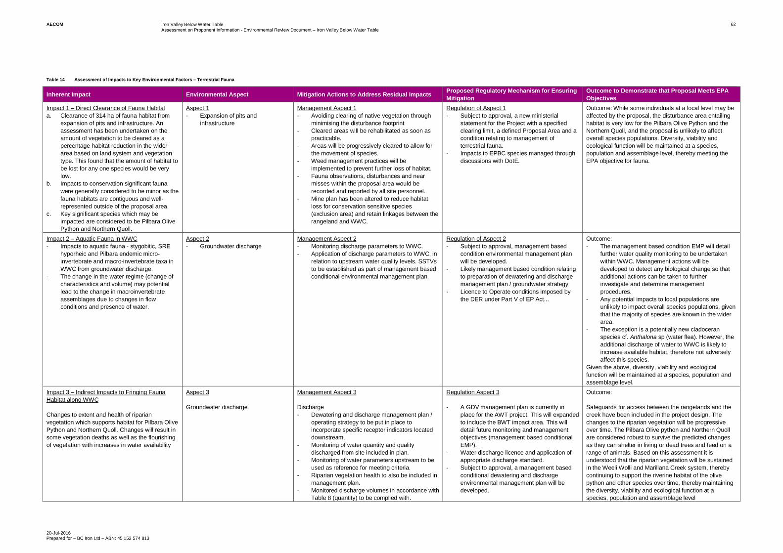
AECOM Iron Valley Below Water TableAssessment on Proponent Information - Environmental Review Document – Iron Valley Below Water Table
20-Jul-2016Prepared for – BC Iron Ltd – ABN: 45 152 574 813
62
Table 14 Assessment of Impacts to Key Environmental Factors – Terrestrial Fauna
Inherent Impact Environmental Aspect Mitigation Actions to Address Residual Impacts Proposed Regulatory Mechanism for EnsuringMitigation
Outcome to Demonstrate that Proposal Meets EPAObjectives
Impact 1 – Direct Clearance of Fauna Habitata. Clearance of 314 ha of fauna habitat from
expansion of pits and infrastructure. Anassessment has been undertaken on theamount of vegetation to be cleared as apercentage habitat reduction in the widerarea based on land system and vegetationtype. This found that the amount of habitat tobe lost for any one species would be verylow.
b. Impacts to conservation significant faunawere generally considered to be minor as thefauna habitats are contiguous and well-represented outside of the proposal area.
c. Key significant species which may beimpacted are considered to be Pilbara OlivePython and Northern Quoll.
Aspect 1- Expansion of pits and
infrastructure
Management Aspect 1- Avoiding clearing of native vegetation through
minimising the disturbance footprint- Cleared areas will be rehabilitated as soon as
practicable.- Areas will be progressively cleared to allow for
the movement of species.- Weed management practices will be
implemented to prevent further loss of habitat.- Fauna observations, disturbances and near
misses within the proposal area would berecorded and reported by all site personnel.
- Mine plan has been altered to reduce habitatloss for conservation sensitive species(exclusion area) and retain linkages between therangeland and WWC.
Regulation of Aspect 1- Subject to approval, a new ministerial
statement for the Project with a specifiedclearing limit, a defined Proposal Area and acondition relating to management ofterrestrial fauna.
- Impacts to EPBC species managed throughdiscussions with DotE.
Outcome: While some individuals at a local level may beaffected by the proposal, the disturbance area entailinghabitat is very low for the Pilbara Olive Python and theNorthern Quoll, and the proposal is unlikely to affectoverall species populations. Diversity, viability andecological function will be maintained at a species,population and assemblage level, thereby meeting theEPA objective for fauna.
Impact 2 – Aquatic Fauna in WWC- Impacts to aquatic fauna - stygobitic, SRE
hyporheic and Pilbara endemic micro-invertebrate and macro-invertebrate taxa inWWC from groundwater discharge.
- The change in the water regime (change ofcharacteristics and volume) may potentiallead to the change in macroinvertebrateassemblages due to changes in flowconditions and presence of water.
Aspect 2- Groundwater discharge
Management Aspect 2- Monitoring discharge parameters to WWC.- Application of discharge parameters to WWC, in
relation to upstream water quality levels. SSTVsto be established as part of management basedconditional environmental management plan.
Regulation of Aspect 2- Subject to approval, management based
condition environmental management planwill be developed.
- Likely management based condition relatingto preparation of dewatering and dischargemanagement plan / groundwater strategy
- Licence to Operate conditions imposed bythe DER under Part V of EP Act...
Outcome:- The management based condition EMP will detail
further water quality monitoring to be undertakenwithin WWC. Management actions will bedeveloped to detect any biological change so thatadditional actions can be taken to furtherinvestigate and determine managementprocedures.
- Any potential impacts to local populations areunlikely to impact overall species populations, giventhat the majority of species are known in the widerarea.
- The exception is a potentially new cladoceranspecies cf. Anthalona sp (water flea). However, theadditional discharge of water to WWC is likely toincrease available habitat, therefore not adverselyaffect this species.
Given the above, diversity, viability and ecologicalfunction will be maintained at a species, population andassemblage level.
Impact 3 – Indirect Impacts to Fringing FaunaHabitat along WWC
Changes to extent and health of riparianvegetation which supports habitat for Pilbara OlivePython and Northern Quoll. Changes will result insome vegetation deaths as well as the flourishingof vegetation with increases in water availability
Aspect 3
Groundwater discharge
Management Aspect 3
Discharge- Dewatering and discharge management plan /
operating strategy to be put in place toincorporate specific receptor indicators locateddownstream.
- Monitoring of water quantity and qualitydischarged from site included in plan.
- Monitoring of water parameters upstream to beused as reference for meeting criteria.
- Riparian vegetation health to also be included inmanagement plan.
- Monitored discharge volumes in accordance withTable 8 (quantity) to be complied with.
Regulation Aspect 3
- A GDV management plan is currently inplace for the AWT project. This will expandedto include the BWT impact area. This willdetail future monitoring and managementobjectives (management based conditionalEMP).
- Water discharge licence and application ofappropriate discharge standard.
- Subject to approval, a management basedconditional dewatering and dischargeenvironmental management plan will bedeveloped.
Outcome:
Safeguards for access between the rangelands and thecreek have been included in the project design. Thechanges to the riparian vegetation will be progressiveover time. The Pilbara Olive python and Northern Quollare considered robust to survive the predicted changesas they can shelter in living or dead trees and feed on arange of animals. Based on this assessment it isunderstood that the riparian vegetation will be sustainedin the Weeli Wolli and Marillana Creek system, therebycontinuing to support the riverine habitat of the olivepython and other species over time, thereby maintainingthe diversity, viability and ecological function at aspecies, population and assemblage level

AECOM Iron Valley Below Water TableAssessment on Proponent Information - Environmental Review Document – IronValley Below Water Table
20-Jul-2016Prepared for – BC Iron Ltd – ABN: 45 152 574 813
63
5.7 Subterranean Fauna5.7.1 EPA Objective
Subterranean Fauna: To maintain representation, diversity, viability and ecological function at the species,population and assemblage level.
The EPA policy and how the BWT proposal has applied the policy through its preparation of this section is foundwithin Appendix H of this ER document
5.7.2 Context/Key Survey Findings
An assessment on the subterranean fauna which may be affected by the BWT proposal has been undertaken andis included as Appendix D4. This included level 2 troglofauna and stygofauna site survey conducted in 2009 and2011. Subsequent targeted sampling in 2015 was undertaken for two potentially restricted stygofauna species.
TroglofaunaTroglofauna are air breathing subterranean fauna that use geology with fissures and voids for habitat. Verticalconnectivity with the surface is important for the supply of carbon and nutrients, while lateral connectivity isimportant for the dispersal of species. The geology of the site is not unique, and is similar both inside and outsideof the proposed pit outlines (Appendix D4)
- Sampling yielded Sixteen species of troglofauna from 112 troglofaunal animals from within the Project area
- 11 of these species were found within the mine pit
- Nine of these 11 are found elsewhere in areas outside of mine pits or elsewhere in the Pilbara.
- The remaining two species of troglofauna (Chilopoda sp. and Lagynochthonius ‘PSE43’) were recorded assingletons, with single animals collected.
The detection of singletons provides no information about the spatial extent of their ranges. The Chilopoda sp.was recorded as a singleton but this may have been due to the poor condition of the specimen which only allowedfor a poor level of identification.
Many of the troglofauna collected at Iron Valley are known more widely in the Pilbara. While some of thesespecies may have a surface dispersal phase, the abundant schizomid Draculoides ‘SCH020’ is highly likely to bea troglobiont without any surface dispersal. Therefore, the distribution of this abundant species can be used as anindicator of the degree of habitat connectivity between impact and reference areas at Iron Valley. Given thatDraculoides ‘SCH020’ occurs both within and to the south of the impact area, there is evidence of habitatconnectivity between the mine pits and the area to the south of them. Nocticola sp. B09, which is also consideredto be a troglobite, has the same pattern of distribution.
Troglofauna distributions suggest that the dolerite dyke that partially transects the project trending in an east /west direction is not a barrier to troglofauna. Four species recorded at the project site are known from both sidesof the dyke.
The pseudoscorpion Lagynochthonius ‘PSE43’ is known from a single juvenile, which provides no informationabout the spatial extent of species range. The ranges of the troglofaunal Lagynochthonius ‘PSE039’ is knownfrom several deposits at Mining Area C, Yandicoogina and at least three orebodies at Jinidi in the Pilbara. Otherspecies have more tightly restricted distributions, such as Lagynochthnius asema which is restricted to Mesa A inthe Robe Valley. Considering the habitat connectivity demonstrated by the distribution of other troglofaunaspecies in the Iron valley project, and the fact that species of Lagynochthonius may be widespread, it isconsidered likely that the range of Lagynochthonius ‘PSE043’ extends outside the proposed mine pits.Consequently, it is concluded that the threat to troglofauna conservation values from mining at the BWT proposalis low for both singletons.
StygofaunaStygofauna are water borne subterranean animals that rely on the presence of groundwater as well as suitablepore spaces typically within 32 m of the surface for a suitable habitat, with abundance typically decreasing withdepth below ground. Habitat within alluvium and calcrete are usually considered to be the most productive, butspecies have been found to occur in moderate abundance in banded iron formations. At Iron Valley the alluvialdrainage channels are considered to be the links between the project and the wider area. There is the potential forthe dolerite dyke that transects the Project area to act as a barrier for stygofauna between the northern and

AECOM Iron Valley Below Water TableAssessment on Proponent Information - Environmental Review Document – IronValley Below Water Table
20-Jul-2016Prepared for – BC Iron Ltd – ABN: 45 152 574 813
64
southern portions. However, studies so far show that the dyke is not acting as a barrier to stygofauna movement.The study, conducted by Bennelongia (Appendix D4) found the following:
- 2,152 specimens of stygofauna found in the Project area comprising 22 species.
- Twenty of the 22 species are known to occur beyond the Project area.
- The two remaining species encountered which are only known from within the pit area, are the OstracodMeridiescandona sp. BOS 171 and Syncarid Bathynella sp. B24.
The Bathynella species was represented by two individuals from one bore and this highly restricted rangerepresentation is likely to be an artefact of sampling. Other Bathynella sp has been sampled at longer ranges, asshown on Figure 18). This figure shows Bathynella Sp. B23 located to the north at the 2 m drawdown contour,and a Bathynella sp. located adjacent to the Marillana Creek some 7 km to the south west of the pits. Thisconnectivity is consistent with the other 20 species of stygofauna represented outside of the project area.
The Ostracod Meridiescandona sp. BOS171, was collected from five drill holes within the area of predictedgroundwater drawdown, the sample locations are shown in Figure 18. This apparent restriction in range is incontrast to the range of other species within the Meridiescandona Genus. This clustering of samples south of thedyke is in contrast to the extent of those collected north of the dyke Figure 19. This contrast is likely due to thedifference in water levels existing on either side of this low permeability dolerite dyke.Table 15 Instances of positive stygofauna collections either side of the dolerite dyke
Species of Stygofauna foundnorth and south of the dyke
(sampling locationsfound)South North
Diacyclops humphreysihumphreysi
14 3
Paramelitidae Genus 2 sp. B01 8 2
Paramelitidae sp. B16 6 1
Paramelitidae sp. B26 3 6
Meridiescandona lucerna 3 2

!(
!(!(
!(
!(
!(!(
!(
!(
WE
ELI W
OLLI C
RE
EK
Qa
PLHj
PLHb
Czc
Czc
Czc
Qs
PLHj
PLHj
CzrQs
PLHj
PLHj
PLHj
Czc
Czk
Czc
Czc
Czc
Czc
Czc
PLHb
PLHj
Czc
2
2
´DATUM GDA 1994, PROJECTION MGA ZONE 50
0 250 500 750 1,000
metres
AECOM does not warrant the accuracy or completeness of information displayed in this map and any person using it does so at their own risk. AECOM shall bear no responsibility or liability for any errors, faults, defects, or omissions in the information.
1:50,000 when printed at A4
www.aecom.com
LEGEND
Development Envelope Boundary Pit
Major Watercourse
Minor Watercourse
2m Drawdown Contour
Qa - Alluvium
Qs - Eolian
Czk - Calcrete
Czc - Colluvium
Czr - Hematite
PLHb - Brockman
PLHj - Weeli Wolli
!( Bathynella sp.
!( Bathynella sp. B23
!( Bathynella sp. B24
!( Meridiescandona sp. BOS171
Map Document: T:\Jobs\42908791\DATA\FIGURES\API_IVP_BWTM_Jan2016\60451502-A015_RB.mxd (rob.mcgregor) A4 size
18
Figure
BC IRON
ASSESSMENT ON PROPONENT
INFORMATION
IRON VALLEY PROJECT –
BELOW WATER TABLE MINING.
Stygofauna Sample Locations ofBathynella and Meridiescandona sp.BOS171
Data sources:Project Layout - BC Iron (22/12/2014)
Base Data: (c) Based on information provided by and
with the permission of the Western Australian LandInformation Authority trading as Landgate (2010).
PROJECT ID
APPROVED BY
CREATED BY
60451502
RNM
CT/MJ
LAST MODIFIED 20 JUL 2016

")
")
")
") ")
")
")
")
")
")
")
")
")
")
")
")
")
")")")")
")
")")
")
")
")
")
")
") ")")
")
")")
")
")
") ")
")")
")
")
")
") ")
")
")
")")
WEEL
I WO
LLI C
REEK
2
´DATUM GDA 1994, PROJECTION MGA ZONE 50
0 250 500 750 1,000
metres
AECOM does not warrant the accuracy or completeness of information displayed in this map and any person using it does so at their own risk. AECOM shall bear no responsibility or liability for any errors, faults, defects, or omissions in the information.
1:30,000 when printed at A4
www.aecom.com
LEGEND
Development Envelope Boundary Mining Tenements
Pit
Major Watercourse
Minor Watercourse
Dolerite Dyke
") Diacyclops humphreysi humphreysi
") Meridiescandona lucerna
") Paramelitidae Genus 2 sp. B01
") Paramelitidae sp. B16
") Paramelitidae sp. B26
Map Document: T:\Jobs\42908791\DATA\FIGURES\API_IVP_BWTM_Jan2016\60451502-A017_RB.mxd (rob.mcgregor) A4 size
19
Figure
BC IRON
ASSESSMENT ON PROPONENT
INFORMATION
IRON VALLEY PROJECT –
BELOW WATER TABLE MINING.
Stygofauna Sampling DistributionNorth and South of Dyke
Data sources:Project Layout - BC Iron (22/12/2014)
Base Data: (c) Based on information provided by and
with the permission of the Western Australian LandInformation Authority trading as Landgate (2010).
PROJECT ID
APPROVED BY
CREATED BY
60451502
RNM
CT/MJ
LAST MODIFIED 20 JUL 2016

AECOM Iron Valley Below Water TableAssessment on Proponent Information - Environmental Review Document – IronValley Below Water Table
20-Jul-2016Prepared for – BC Iron Ltd – ABN: 45 152 574 813
67
The Hydrogeological cross sections for the pit locations identify a layer of alluvium approximately 30 m thick(Figure 4). This layer is thinnest at the top of the dyke, where it is within 10 m of the surface. The groundwater thatis found within the tenement, south of the dyke, is hydro-geologically inhibited by the low permeability barrier ofthe dyke. It is proposed that following a heavy rainfall event, especially in the case of a cyclone, the southerngroundwater levels increase and overtop the dyke allowing water levels to also rise on the northern side. Theresults from the study suggests that the depth of the suitable alluvial habitat allows the passage of stygofaunasuch as those recorded on both sides of the dyke including the closely related Meridiescandona lucerna, as wellas the species in question, the Meridiescandona sp. BOS171. The depth which is reached with the progressivereduction of groundwater levels after such heavy rainfall events means that abundance of individuals is reducedto the point where collection is unlikely.
The additional mechanism that allows connectivity to the north is that the dolerite dyke is truncated within theeastern boundary of the tenement. Figure 20 shows a cross section of how the groundwater changes around thiseastern boundary without the presence of the dyke. As such, maintaining the connectivity within the alluvium, thestygofauna is also able to connect to similar habitat around the eastern edge of the dyke to the alluvials furthernorth.
The connectivity of habitat inside and outside the project area is demonstrated by the detection of 20 of the 22species included in this study. This includes the largest stygofauna species known from the Pilbara, the Pygolabissp. B01, which are known to occur in surrounding parts of the Weeli Wolli / Marillana Creek drainage channel.Given the extent of the alluvials, the range of Meridiescandona sp. BOS171 may continue farther north to areaswhere groundwater is shallower, so that a significant proportion of the population would be outside the predictedarea of groundwater drawdown. This would mean that Meridiescandona sp. BOS171 would have a range of thesame order of magnitude as other species of Meridiescandona.

PROJECT ID 60451502
CREATED BY RNM
APPROVED BY CJT/MJ
LAST MODIFIED 14/07/2016
Figure
T:\Jobs\42908791\DATA\FIGURES\API_IVP_BWTM_Jan2016\60451502-E004.xlsx A3 size
AECOM doe
s no
t warrant the
accurac
y or com
pleten
ess of in
form
ation disp
laye
d in this map
and
any
perso
n us
ing it do
es so at the
ir ow
n ris
k. AECOM sha
ll be
ar no resp
onsibility or liab
ility for any
errors, fau
lts, de
fects, or om
ission
s in the
inform
ation.
20
ASSESSMENT ON PROPONENT
INFORMATION
IRON VALLEY PROJECT - BELOW WATER
TABLE MINING
BC IRON
Subterranean Fauna Habitat Connectivity
Data sources:AQ2 Data
Base Data: (c)
www.aecom.com
LEGEND
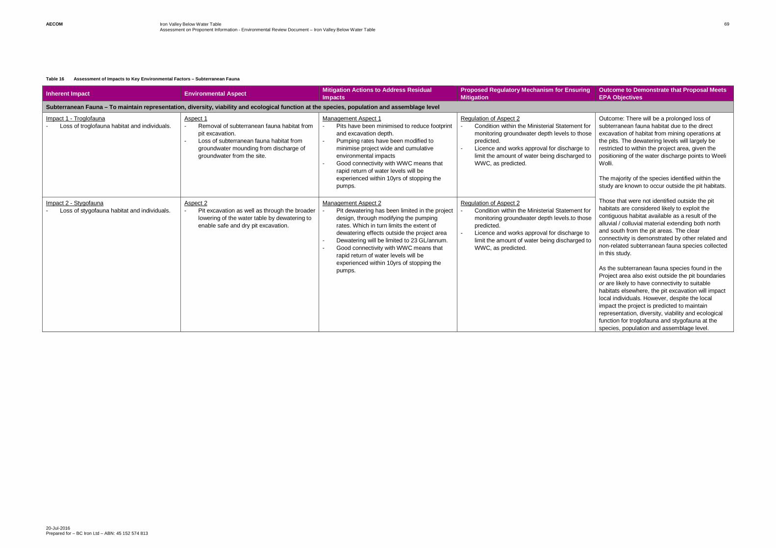
AECOM Iron Valley Below Water TableAssessment on Proponent Information - Environmental Review Document – Iron Valley Below Water Table
20-Jul-2016Prepared for – BC Iron Ltd – ABN: 45 152 574 813
69
Table 16 Assessment of Impacts to Key Environmental Factors – Subterranean Fauna
Inherent Impact Environmental Aspect Mitigation Actions to Address ResidualImpacts
Proposed Regulatory Mechanism for EnsuringMitigation
Outcome to Demonstrate that Proposal MeetsEPA Objectives
Subterranean Fauna – To maintain representation, diversity, viability and ecological function at the species, population and assemblage level
Impact 1 - Troglofauna- Loss of troglofauna habitat and individuals.
Aspect 1- Removal of subterranean fauna habitat from
pit excavation.- Loss of subterranean fauna habitat from
groundwater mounding from discharge ofgroundwater from the site.
Management Aspect 1- Pits have been minimised to reduce footprint
and excavation depth.- Pumping rates have been modified to
minimise project wide and cumulativeenvironmental impacts
- Good connectivity with WWC means thatrapid return of water levels will beexperienced within 10yrs of stopping thepumps.
Regulation of Aspect 2- Condition within the Ministerial Statement for
monitoring groundwater depth levels to thosepredicted.
- Licence and works approval for discharge tolimit the amount of water being discharged toWWC, as predicted.
Outcome: There will be a prolonged loss ofsubterranean fauna habitat due to the directexcavation of habitat from mining operations atthe pits. The dewatering levels will largely berestricted to within the project area, given thepositioning of the water discharge points to WeeliWolli.
The majority of the species identified within thestudy are known to occur outside the pit habitats.
Those that were not identified outside the pithabitats are considered likely to exploit thecontiguous habitat available as a result of thealluvial / colluvial material extending both northand south from the pit areas. The clearconnectivity is demonstrated by other related andnon-related subterranean fauna species collectedin this study.
As the subterranean fauna species found in theProject area also exist outside the pit boundariesor are likely to have connectivity to suitablehabitats elsewhere, the pit excavation will impactlocal individuals. However, despite the localimpact the project is predicted to maintainrepresentation, diversity, viability and ecologicalfunction for troglofauna and stygofauna at thespecies, population and assemblage level.
Impact 2 - Stygofauna- Loss of stygofauna habitat and individuals.
Aspect 2- Pit excavation as well as through the broader
lowering of the water table by dewatering toenable safe and dry pit excavation.
Management Aspect 2- Pit dewatering has been limited in the project
design, through modifying the pumpingrates. Which in turn limits the extent ofdewatering effects outside the project area
- Dewatering will be limited to 23 GL/annum.- Good connectivity with WWC means that
rapid return of water levels will beexperienced within 10yrs of stopping thepumps.
Regulation of Aspect 2- Condition within the Ministerial Statement for
monitoring groundwater depth levels.to thosepredicted.
- Licence and works approval for discharge tolimit the amount of water being discharged toWWC, as predicted.

AECOM Iron Valley Below Water TableAssessment on Proponent Information - Environmental Review Document – IronValley Below Water Table
20-Jul-2016Prepared for – BC Iron Ltd – ABN: 45 152 574 813
70
5.8 Heritage5.8.1 EPA Objective
Heritage: To ensure that historical and cultural associations, and natural heritage, are not adversely affected.
The EPA policy and how the BWT proposal has applied the policy through its preparation of this section is foundwithin Appendix H of this ER document
5.8.2 Context/Key Survey Findings
The development envelope is located within the Nyiyaparli Native Title Claim, who continues to be consultedregarding the Iron Valley Above and Below Water Table Project (Section 3). In December 2010, IOH entered intoa Land Access Deed (LAD) with the Nyiyaparli People. The Deed sets out key obligations for both parties on arange of matters including the management of impacts on Aboriginal heritage. BCP and the Nyiyaparli meet twicea year to review the obligations associated with the LAD and to ensure that both parties are compliant with theirrespective obligations. A requirement of the LAD is to ensure that prior to any ground disturbing works beingconducted the aboriginal heritage landscape is understood. In compliance with the requirement of the LAD, BCPconducted a site identification archaeological and ethnographic surveys of the area of land to be disturbed for theAWT project (the area on tenement M47/1439 to the north of the central creek). The surveys were completed overthree separate fieldtrips between February and April 2013. Nyiyaparli claim group members with authority tospeak for the survey area actively participated in the heritage assessment, including:
- Endorsing the fieldwork methodology;
- Working collaboratively with the Heritage consultants to record heritage places to site identification standard;and
- Providing clear indication as to the importance and significance of each heritage place.
The survey efforts resulted in the identification of 17 new heritage places in addition to the 2 heritage placesalready recorded by the DAA. Following extensive consultation with the Nyiyaparli People, BCP applied for twoAboriginal Heritage Act (AHA) 1972 section 18s to disturb 16 of the heritage places identified. The section 18consents were received in 2013 and all heritage places to be disturbed were salvaged by the Nyiyaparli prior todisturbance in 2014.
In preparation for the BWT project, BCP has completed additional archaeological and ethnographic heritagesurveys over the area on tenement M47/1439 to the south of the southern-most creek. This survey resulted in theidentification of an additional heritage place and one additional DAA site. BCP have prepared an additionalsection 18 application and have completed initial consultation with the Nyiyaparli People. The section 18application will be progressed at an appropriate time closer to the time that mining will occur to the south of thecentral creek (timing likely to be in 3-5 years).
The heritage values associated with the project have historically been impacted (i.e. 16 heritage places impacted)and the BWT project will impact an additional 3 heritage places/sites. However, the tenement area is smallcompared to the overall Claim area and the Nyiyaparli have been supportive of the project. The greatest heritagevalues of the Nyiyaparli Country are along the Weeli Wolli Creek and the values on the tenements associated withthis project are replicated many times over across the remaining claim area.
These sites are further described in Table 17. The desktop heritage search is included in Appendix E. The surveyresults have been mapped which has provided a clear understanding of the cultural heritage landscape Figure 21.Table 17 Location of Aboriginal Heritage Sites
Heritage site / place ID Type Extent of Impact
DIA 7030 Yandicoogina RailEasement 5
Rock Shelter Complete disturbance
DIA 7031 Yandicoogina RailEasement 4
Rock Shelter Complete disturbance
IOHAS13-01 Artefact Scatter Complete disturbance
IOHAS13-02 Artefact Scatter Complete disturbance
IOHAS13-03 Artefact Scatter Complete disturbance
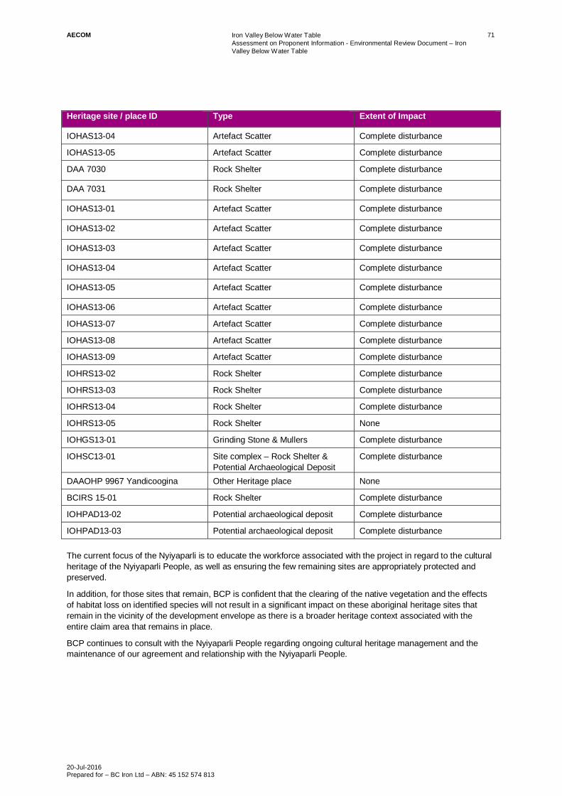
AECOM Iron Valley Below Water TableAssessment on Proponent Information - Environmental Review Document – IronValley Below Water Table
20-Jul-2016Prepared for – BC Iron Ltd – ABN: 45 152 574 813
71
Heritage site / place ID Type Extent of Impact
IOHAS13-04 Artefact Scatter Complete disturbance
IOHAS13-05 Artefact Scatter Complete disturbance
DAA 7030 Rock Shelter Complete disturbance
DAA 7031 Rock Shelter Complete disturbance
IOHAS13-01 Artefact Scatter Complete disturbance
IOHAS13-02 Artefact Scatter Complete disturbance
IOHAS13-03 Artefact Scatter Complete disturbance
IOHAS13-04 Artefact Scatter Complete disturbance
IOHAS13-05 Artefact Scatter Complete disturbance
IOHAS13-06 Artefact Scatter Complete disturbance
IOHAS13-07 Artefact Scatter Complete disturbance
IOHAS13-08 Artefact Scatter Complete disturbance
IOHAS13-09 Artefact Scatter Complete disturbance
IOHRS13-02 Rock Shelter Complete disturbance
IOHRS13-03 Rock Shelter Complete disturbance
IOHRS13-04 Rock Shelter Complete disturbance
IOHRS13-05 Rock Shelter None
IOHGS13-01 Grinding Stone & Mullers Complete disturbance
IOHSC13-01 Site complex – Rock Shelter &Potential Archaeological Deposit
Complete disturbance
DAAOHP 9967 Yandicoogina Other Heritage place None
BCIRS 15-01 Rock Shelter Complete disturbance
IOHPAD13-02 Potential archaeological deposit Complete disturbance
IOHPAD13-03 Potential archaeological deposit Complete disturbance
The current focus of the Nyiyaparli is to educate the workforce associated with the project in regard to the culturalheritage of the Nyiyaparli People, as well as ensuring the few remaining sites are appropriately protected andpreserved.
In addition, for those sites that remain, BCP is confident that the clearing of the native vegetation and the effectsof habitat loss on identified species will not result in a significant impact on these aboriginal heritage sites thatremain in the vicinity of the development envelope as there is a broader heritage context associated with theentire claim area that remains in place.
BCP continues to consult with the Nyiyaparli People regarding ongoing cultural heritage management and themaintenance of our agreement and relationship with the Nyiyaparli People.

!
!
!
!
!!
!
WEEL
I WO
LLI C
REEK
Pit C
PIT S
Infrastructure Area
Waste RockLandform 2
Pit E
Waste RockLandform 2
Pit E
Waste RockLandform 1
Waste RockLandform 2
Pit N
IOHAS13-02
IOHAS13-06
IOHAS13-09
IOHAS13-03
IOHAS13-07
IOHAS13-05
IOHAS13-04
IOHAS13-08
IOHSC13-01
DIA 7030
IOHAS13-01
IOHGS13-01
IOHRS13-04
IOHRS13-03
IOHRS13-02
IOHPAD13-03
IOHPAD13-02
DIA Site 7031
DAA OHP 9967 Yandicoogina
BCIRS-15-01
IOHRS13-05
´DATUM GDA 1994, PROJECTION MGA ZONE 50
0 250 500 750 1,000
metres
AECOM does not warrant the accuracy or completeness of information displayed in this map and any person using it does so at their own risk. AECOM shall bear no responsibility or liability for any errors, faults, defects, or omissions in the information.
1:30,000 when printed at A4
www.aecom.com
LEGEND
Development Envelope Boundary
Cultural Material Salvage
Heritage Exclusion Zone
Waste Rock Landform
Pit
Infrastructure Areas
Major Watercourse
Minor Watercourse
Map Document: T:\Jobs\42908791\DATA\FIGURES\API_IVP_BWTM_Jan2016\60451502-A021.mxd (rob.mcgregor) A4 size
21
Figure
BC IRON
ASSESSMENT ON PROPONENT
INFORMATION
IRON VALLEY PROJECT –
BELOW WATER TABLE MINING.
Heritage
Data sources:Project Layout - BC Iron (22/12/2014)
Base Data: (c) Based on information provided by and
with the permission of the Western Australian LandInformation Authority trading as Landgate (2010).
PROJECT ID
APPROVED BY
CREATED BY
60451502
RNM
CT
LAST MODIFIED 20 JUL 2016

AECOM Iron Valley Below Water TableAssessment on Proponent Information - Environmental Review Document – Iron Valley Below Water Table
20-Jul-2016Prepared for – BC Iron Ltd – ABN: 45 152 574 813
73
Table 18 Assessment of Impacts to Key Environmental Factors – Heritage
Inherent Impact Environmental Aspect Mitigation Actions to Address ResidualImpacts
Proposed Regulatory Mechanism for EnsuringMitigation
Outcome to Demonstrate that Proposal MeetsEPA Objectives
Heritage: To ensure that historical and cultural associations, and natural heritage, are not adversely affected.
Impact 1 – direct impacts to registered sites- Loss of registered sites DAA 7031
Yandicoogina Rail Easement 4 and DAA7030 Yandicoogina Rail Easement 5 andBCIRS15-01.
Aspect 1- As a result of clearing for project
infrastructure namely waste rock landformand pit extension.
Management Aspect 1- Pits have been minimised to reduce footprint
and excavation depth leading to avoidingother aboriginal sites of interest such asIOHRS13-05, IOHGS13-01 andDAAOHP9967 Yandicoogina as part of theproject footprint design.
- Artefacts collected through the disturbanceprocess will be stored and available to theNyiyaparli People to collect
Regulation of Aspect 2- BCP will seek agreement with the Nyiyaparli
People and the DAA and formally requestaccess to disturb the sites under S18 of theAboriginal Heritage Act.
Outcome:Loss of registered site. Proposed registered sitesidentified for disturbance will be done so, followingformal disturbance process through the AH Act.and discussions with DAA and the NyiyaparliPeople.For those sites that remain, BCP is confident thatthe clearing of the native vegetation and theeffects of habitat loss on identified species will notresult in a significant impact on these aboriginalheritage sites that remain in the vicinity of thedevelopment envelope as there is a broaderheritage context associated with the entire claimarea that remains in place.
Impact 2 – indirect impacts to registered sites- Indirect impact to heritage resulting from
clearance of vegetation
Aspect 2- As a result of clearing for project
infrastructure namely waste rock landformand pit extension.
Management Aspect 2- Ongoing consultation and discussions with
the Nyiyaparli People and the DAA has notidentified any specific feature of theenvironment in the vicinity of the project thatwould affect the remaining sites of aboriginalheritage.
-
Regulation of Aspect 2- none

AECOM Iron Valley Below Water TableAssessment on Proponent Information - Environmental Review Document – IronValley Below Water Table
20-Jul-2016Prepared for – BC Iron Ltd – ABN: 45 152 574 813
74
5.9 Rehabilitation and Decommissioning5.9.1 EPA Objective
Rehabilitation and Decommissioning: To ensure that premises are decommissioned and rehabilitated in anecologically sustainable manner.
The EPA policy and how the BWT proposal has applied the policy through its preparation of this section is foundwithin Appendix H of this ER document
5.9.2 Context/Key Survey Findings
The Iron Valley project already has a mine closure plan that was submitted and approved by the DMP as part ofthe AWT Mining Act assessment in 2012. The three-year review and update cycle for the existing mine closureplan is now due, and the plan will be updated to include the additional features of the BWT proposal. Primarily,this will include the risks to closure of the following components, which are integrated into the domains of theupdated Mine closure plan:
- Integrated tailings facility cells within the WRLs,
- The likelihood of pit lakes at closure,
- The new and expanded pits and
- The surface water aspects associated with the changes in site.
The current mine closure plan will meet the requirements of the OEPA/DMP Guidelines for Preparing MineClosure Plans (2015). The complete Mine closure plan will be submitted to the DMP with the Mining Proposal forapproval. This section provides an insight into the changes required to the Mine closure plan and covers therehabilitation and mine closure objectives, the revised risks associated with the BWT proposal as well as detail onthe closure strategy related to the revised surface water infrastructure.
5.9.3 Objectives
The overall objective of the rehabilitation and mine closure plan is to leave the site in a long-term, stable, safe andnon-polluting condition, with a self-sustaining vegetative cover, so that pastoral activities can resume wherepracticable. Successful achievement of closure objectives will allow the tenements to be relinquished without anyfuture liability for the company or the community. The key closure objectives presented in the AWT Project mineclosure plan have been developed and modified to ensure relevance to the AWT and BWT Project combinedThese refined objectives are:
- The Project area is safe
- The rehabilitated land surfaces are structurally stable
- The rehabilitated ecosystem is self-sustaining, consistent with final land use
- The pit void, as well as safe, is stable and non-polluting
- The rehabilitated land surfaces are profiled to integrate into natural flow regimes
- The Project area is non-polluting with respect to surface water, groundwater and soils
- Aboriginal heritage values are preserved and maintained where practicable
- Stakeholders support final land use and accept completion criteria.
5.9.4 Risk assessment
As part of the mine closure plan update, a risk assessment workshop was undertaken for the proposal to identifythe inherent risks, controls and residual risks posed by the Project to a successful site closure. The residual highand medium level risks have been summarised in this section. The complete risk assessment has been includedas Appendix F.
The following project risks at closure were identified as high and medium and are presented in Table 24, below.
· WRL of up to 150m in height exposing top batters to wind/water erosion (high)
· Spills from TSF resulting in injury or loss of life (high)

AECOM Iron Valley Below Water TableAssessment on Proponent Information - Environmental Review Document – IronValley Below Water Table
20-Jul-2016Prepared for – BC Iron Ltd – ABN: 45 152 574 813
75
· Presence of weeds (medium)
· Presence of people and or feral animals during closure leading to injury or loss of life (medium)
· Fauna access to rehabilitation leading to its failure (medium)
· Failure of vegetation resulting in dust generation and impacts on local receptors (medium)
· Soil erosion in rehabilitated areas leading to failure of rehabilitation (medium)
· Hydrocarbon spills caused by closure activities, leading to remedial work (medium)
· Failure of eastern WRL2 batter due to high volumes and subsequent erosion/rehabilitation failure(medium)
· Development of hypersaline pit lake leading to fauna and flora death (medium)
· Presence of pit lake leading to attracting fauna and people post closure (medium)
· Failure of abandonment bund leading to uncontrolled access and potential injury or death (medium)
· Cessation of discharge resulting in change to GDE/riparian veg (medium)
· Return of groundwater levels resulting in redistribution of subterranean fauna (medium)
5.9.5 Surface water at closure
In addition to those impacts above, updated surface water infrastructure which is consistent with the currentsurface water management plan for AWT has also changed with the BWT proposal. The proposed modificationsare consistent with those as part of AWT and include controlled spill ways into the pits, diversion bunds linking tonatural water courses reporting to WWC through the development of new and elevated WRLs on site. Theobjective of the surface water infrastructure throughout operations and into closure is to maintain flow of water tothe WWC system. The hydrological processes, section 5.3, of this document discusses the managementinfrastructure. The following are likely to be present at closure.
Figure 12 shows preliminary surface water control measures for the BWT Proposal. These details will beconsidered and developed into the updated surface water management plan. The measures proposed for BWTwill be consistent with those already approved with the intent on protecting site infrastructure and landforms fromflooding.
1. Currently installed reinforced bund and “spillway” to manage water flowing into the Stage 1 mine pit (southend of the Pit C) from the C15 watercourse. This was intended to allow for the controlled release of waterinto the pit, and to mitigate erosion of the pit safety bund and pit crest. Surface water entering the pit in thismanner was proposed to be pumped out and used for dust suppression or returned to a natural surfacewater channel. This spill way will be progressively moved and maintained open until closure. The design andhigh permeability of WRLs will allow infiltration of rainfall, therefore the volume of stormwater runoff fromouter slopes should be minor. The WRL2 that will be placed to the west of Pit C as the mine life progresseswill occupy much of this catchment at closure thereby reducing volume and rate of flow. The remaining flowgenerated post closure is proposed to be absorbed into the WRL2 or diverted.
2. For the proposed Stage 2 mine pit (north end of the Pit C) a diversion bund to divert the 1:100-yr peak flowwithin the northern main branches of the C16 watercourse. This branch will be integrated into the drainageaccompanying the road in that part of the tenement, while the southern branch may accommodate areinforced bund and spillway similar to that included for the central section of pit C.
3. Surface water management for the C13 catchment will initially be designed to allow floodwater to report topit S in a controlled manner. As the mine develops and along with the backfilling of Pit S, the flood water willbe diverted south around the pit at closure
4. The majority of the surface water for Catchment C14 will be directed to flow along its current path betweenthe two WRLs in the southern part of the tenement. An exclusion zone / corridor down to a minimum of 25 meither side of the creek line is proposed to maintain drainage of floodwaters to WWC. Protection and surfacewater management of WRLs adjacent to creek line will be applied using competent waste material outsidethe WRL to heights adequate to minimise scouring of the base of the WRLs and maintain integrity andstability for a PMP/PMF post closure.
AECOM Iron Valley Below Water TableAssessment on Proponent Information - Environmental Review Document – IronValley Below Water Table
20-Jul-2016Prepared for – BC Iron Ltd – ABN: 45 152 574 813
76
5. The southern branch of catchment C14 may be diverted north as to join the exclusion zone creek line. Thiswill be aided by the proximity of the southern-most component of WRL2 which will facilitate the creation ofthe diversion through its changes to local topography (due to construction of WRL).
Pit LakeFollowing cessation of mining, and water extraction, the water levels in the pits are expected to recover withinapproximately 10 years. Pit-infilling is planned to above water table for pits E and S to eliminate any potential pitlakes from forming. Pits C and N although partially back filled, will develop pit lakes post closure as they will notbe completely back filled to a level above the water table. These two pit lakes will be through-flow lakes, in whichwater flow is maintained and water is ‘refreshed’.

AECOM Iron Valley Below Water TableAssessment on Proponent Information - Environmental Review Document – Iron Valley Below Water Table
20-Jul-2016Prepared for – BC Iron Ltd – ABN: 45 152 574 813
77
Table 19 Assessment of Impacts to Key Environmental Factors – Rehabilitation and decommissioning
Inherent Impact Environmental Aspect Mitigation Actions to Address ResidualImpacts
Proposed Regulatory Mechanism for EnsuringMitigation
Outcome to Demonstrate that Proposal MeetsEPA Objectives
Rehabilitation and decommissioning – To ensure that premises are decommissioned and rehabilitated in an ecologically sustainable manner.
Impact 1 – Tailing Storage FacilityThe potential impacts with regards to the TSF abreach of the TSF as follows:- Fauna fatalities and degradation of fauna
habitat.- Degradation of flora and vegetation.- Safety aspects (potential for loss of life).
Aspect 1- Design and quality of construction of the
Project
Management Aspect 1- The TSF will be appropriately designed by a
geotechnical engineer to prevent failure andencapsulated within the WRL.
- The TSF will be located away from thedrainage line in the south of the Project area.
- An appropriate period of post closuremonitoring will be undertaken.
Regulation of Aspect 1- An amended mine closure plan will be
prepared and submitted to the DMP forapproval.
- Mining Act 1978.- Works approval under Part V of EP Act,
regulated by DER.
Outcome: Closure of the Project will be managedsubject to approval of the mining proposal andmine closure plan.It is considered these provisions will enable theProject to be closed with a safe, stable,sustainable and non-polluting landform meetingthe EPA’s Objective for this factor.
Impact 2 – Site safety and stability of pit andlandformsFailure of the landforms and pit could lead torelease of sediments into the environment andpotential safety implications.
Aspect 2- Construction of the pits and WRL
Management Aspect 2- The pits and landforms will be appropriately
designed by a qualified geotechnicalengineer to reduce the risk of failure.Appropriate setbacks to the edge of thetenement area and surface water featureexclusion area will be put in place
- Access to the site will be reduced by theremoval of access roads, signage andconstruction of safety bunds.
- Construction of project features both pre andpost closure will be outside the zones ofinstability
Regulation of Aspect 2- The design will be subject to Regulator
(DMP) approval prior to construction- An amended mine closure plan will be
prepared and submitted to the DMP forapproval.
- Mining Act 1978.
Outcome: The limited AMD or MD potential of theTSF waste and waste rock coupled with thedesign requirements of a TSF and WRL and pitstability will ensure that the premises can beclosed, decommissioned and rehabilitated in anecologically sustainable manner. Thereby meetingthe EPA objective.
Impact 3 – Pit LakesSource of potential contamination.
Aspect 3Presence of the pit lakes post closure
Management Aspect 3All pits except C and N will be backfilled to abovethe water table. Pits C and N are located on ahydrogeological gradient allowing groundwater toflow through the system. This reduces the risk ofthe pits developing into groundwater sinks.
Regulation of Aspect 3- An amended mine closure plan will be
prepared and submitted to the DMP forapproval.
- Mining Act 1978
Outcome: the resulting pit lakes will not becomecontaminant sinks, thereby being ecologicallysustainable post closure and meeting the EPAobjective for this factor.
Impact 4 – Inadequate topsoils and seed volumesand seed viability for rehabilitation.A lack of topsoil and seed bank for the Projectmay lead to the following:- Inadequate rehabilitation.- Surface instability on rehabilitated landforms.- Erosion of rehabilitated landforms.
Aspect 4- Rehabilitation of the Project site
Management Aspect 4- Progressive rehabilitation will be undertaken
to test adequacy of topsoil and seed.- Rehabilitation and seed propagation trials
will be undertaken.- The seed list will be modified as required
following the rehabilitation trials.- Additional topsoil will be generated by rock
mulching should it be required.
Regulation of Aspect 4- A mining proposal and mine closure will be
prepared and submitted to the DMP forapproval.
- Mining Act 1978.
Outcome: Management measures providesafeguard for sustaining vegetation rehabilitationin accordance with the EPA objective.

AECOM Iron Valley Below Water TableAssessment on Proponent Information - Environmental Review Document – Iron Valley Below Water Table
20-Jul-2016Prepared for – BC Iron Ltd – ABN: 45 152 574 813
78
Inherent Impact Environmental Aspect Mitigation Actions to Address ResidualImpacts
Proposed Regulatory Mechanism for EnsuringMitigation
Outcome to Demonstrate that Proposal MeetsEPA Objectives
Impact 5 – surface water- Potential for erosion to scour landforms
during high volume rainfall events PMP- Potential removal of surface water from the
system as it traverses the site- Potential for erosion to degrade the walls of
the remaining open pit lakes post closure.
Aspect 5- Landform construction- Positioning and type of surface water
infrastructure
Management Aspect 5- An exclusion zone / corridor down to 25 m
either side of the creek line is proposed tomaintain drainage of floodwaters to WWC
- Protection and surface water management ofWRLs adjacent to creek line will be appliedusing competent waste material outside theWRL to heights adequate to minimisescouring of the base of the WRLs andmaintain integrity and stability for aPMP/PMF post closure
- Diversion bunds will be integrated wherepossible with the abandonment budssurrounding the site. The diversion isproposed to link to existing natural watercourses. Rainfall within the site, will bedirected where appropriate to the exclusionzone linking to WWC.
- Pit wall erosion on post closure pit lakes isproposed to be avoided by diverting mainwater flows around the site, or towards theexclusion zone. Only rainfall within the site isproposed to report to pit. The WRLs arewater capturing by design and little excessrunoff is expected under these circumstance.
- A mining proposal and mine closure will beprepared and submitted to the DMP forapproval.
- Mining Act 1978.
Outcome: management measures provide freeflow of water between the rangelands in the westto WWC.
WRL design protects final landforms during PMPrainfall events and prevent them from washing intoWWC.
Diverted flow around the site will link existingwater courses and WWC using abandonmentbunds as appropriate.
With these outcomes, BCP is confident that theclosure criteria and the EPA objective will be met.
Impact 6 – Rehabilitation failure from excessiveexposure to wind and water erosionLeads to a reduction in the potential for successfulrehabilitation.
Aspect 6Presence of landforms in areas subject to fastwater volume flows during flooding events.
Management Aspect 6- Progressive rehabilitation- Landform design to account for height and
exposure to weathering- Provision of adequate protection in surface
water prone areas susceptible to erosion
Regulation of Aspect 6- A mining proposal and mine closure will be
prepared and submitted to the DMP forapproval.
- Mining Act 1978.
Outcome:The current mine closure plan is being updated aspart of its cycle. This includes commitment fordesign, vegetation rehabilitation trials to becompleted as well as ensuring an adequate seedstock is available as required during the life ofmine to achieve rehabilitation at closure. The sign-off by the geotechnical engineer and the DMP aspart of the Mining Proposal and Mine Closure planupdate, will govern the adequacy of the measuresincluded in the mine closure strategy. Thesemeasures enable this impact to have an outcomethat meets the EPA objective for rehabilitation anddecommissioning.

AECOM Iron Valley Below Water TableAssessment on Proponent Information - Environmental Review Document – IronValley Below Water Table
20-Jul-2016Prepared for – BC Iron Ltd – ABN: 45 152 574 813
79
5.10 Offsets5.10.1 EPA Objective
Offsets: To counterbalance any significant residual environmental impacts or uncertainty through the applicationof offsets.
The EPA policy and how the BWT proposal has applied the policy through its preparation of this section is foundwithin Appendix H of this ER document
5.10.2 Context/Key Survey Findings
Environmental aspects of the proposal were assessed for potential significant residual impacts. These residualimpacts are limited to the vegetation communities identified within the clearing footprint that were found to be ingood to excellent condition.
The EPA considers that the cumulative environmental impact from the growth in mining in the Pilbara needs to beaddressed so that conservation management actions can be implemented proactively and the costs associatedwith these are divided between all users of the region (not just the last comers). The EPA considers that theincreased amount of clearing of native vegetation in the Pilbara Bioregion, combined with the predicted futureactivities requiring clearing and other impacts from pastoralism and fires, is likely to result in a significant impacton environmental values. Subsequently the EPA has determined that a proactive approach to limiting theseimpacts is required and that a possible solution is the establishment of a strategic regional conservation initiativefor the pooling of offset funds in the Pilbara.
This proposal design has incorporated adherence to the mitigation hierarchy of avoid, minimise, rehabilitate andoffset. The clearing footprint has been avoided and minimised through various mechanisms and provisions, pitbackfilling, progressive rehabilitation, exclusion zone provision, integrated TSF and landfill in WRLs.
The EPA sees considerable merit in proponents contributing to a strategic regional conservation initiative for thePilbara region, and has recommended such an approach for proposals in the area. This approach toenvironmental offsets has established an appropriate body, with rigorous and transparent governancearrangements, to implement initiatives to improve the environmental values within the Pilbara IBRA region. Theoffsets for the BWT propsosal will be a contribution to the Pilbara Offsets Fund relative to the 314 ha of good toexcellent vegetation to be cleared as part of this proposal consistent with other proponents in the region.
This is consistent with the 2014 WA environmental offsets guidelines (EPA 2014b). The residual clearing of thisvegetation is for BCP to pay the applied rate for the unavoidable clearing. This is consistent with the approachapplied to the AWT assessment. This similar approach has been confirmed in the consultation with the OEPA aspart of this proposal.

AECOM Iron Valley Below Water TableAssessment on Proponent Information - Environmental Review Document – Iron Valley Below Water Table
20-Jul-2016Prepared for – BC Iron Ltd – ABN: 45 152 574 813
80
Table 20 Assessment of Impacts to Key Environmental Factors - Offsets
Inherent Impact Environmental Aspect Mitigation Actions to Address ResidualImpacts
Proposed Regulatory Mechanism for EnsuringMitigation
Outcome to Demonstrate that Proposal MeetsEPA Objectives
Offsets – To counterbalance any significant residual environmental impacts or uncertainty through the application of offsets.
ImpactLoss of 314 ha of vegetation considered to be ingood to excellent condition
Aspect- Vegetation clearing to occur as part of
project construction phase.
Management Aspect- The clearance footprint has been minimised,
by incorporating integrated TSFs within theWRLs, substantial backfilling of pits andexclusion zones being maintained for faunapassage and surface water through flow.
- Areas will be progressively rehabilitated- The existing closure plan (prepared for AWT)
will be updated to account for the changesassociated with this BWT proposal, whilstmaintaining a proposal that can be closed inan ecologically sustainable manner,consistent with agreed outcomes and landuses.
Regulation of Aspect- A condition regarding offsets will be detailed
in the ministerial statement.- Approval of BCP’s mine closure plan update
to account for the rehabilitation effort, trialsand progress towards closure of the BWTproject.
Outcome: The proposed offset will counterbalancethe residual impact of clearance of nativevegetation for the BWT proposal.The offsets being applied to BWT relate only tothe clearing of 314 ha of good to excellent qualitynative vegetation. The project has applied themitigation hierarchy of avoid, minimise,rehabilitate and offset. The clearing footprint hasbeen avoided and minimised through variousmechanisms and provisions, pit backfilling,progressive rehabilitation, exclusion zoneprovision, integrated TSF and landfill in WRLs.
Type of offset: provision of funds to a Pilbarastrategic conservation initiative, consistent withother proponents in the region.
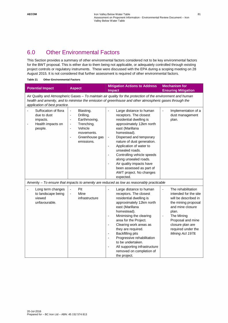
AECOM Iron Valley Below Water TableAssessment on Proponent Information - Environmental Review Document – IronValley Below Water Table
20-Jul-2016Prepared for – BC Iron Ltd – ABN: 45 152 574 813
81
6.0 Other Environmental FactorsThis Section provides a summary of other environmental factors considered not to be key environmental factorsfor the BWT proposal. This is either due to them being not applicable, or adequately controlled through existingproject controls or regulatory instruments. These were discussed with the EPA during a scoping meeting on 28August 2015. It is not considered that further assessment is required of other environmental factors.Table 21 Other Environmental Factors
Potential Impact Aspect Mitigation Actions to AddressImpact
Mechanism forEnsuring Mitigation
Air Quality and Atmospheric Gases – To maintain air quality for the protection of the environment and humanhealth and amenity, and to minimise the emission of greenhouse and other atmospheric gases through theapplication of best practice.- Suffocation of flora
due to dustimpacts.
- Health impacts onpeople.
- Blasting.- Drilling.- Earthmoving.- Trenching.- Vehicle
movements.- Greenhouse gas
emissions.
- Large distance to humanreceptors. The closestresidential dwelling isapproximately 12km northeast (Marillanahomestead).
- Dispersed and temporarynature of dust generation.
- Application of water tounsealed roads.
- Controlling vehicle speedsalong unsealed roads.
- Air quality impacts havebeen assessed as part ofAWT project. No changesexpected.
- Implementation of adust managementplan.
Amenity – To ensure that impacts to amenity are reduced as low as reasonably practicable
- Long term changesto landscape beingviewedunfavourable.
- Pit- Mine
infrastructure
- Large distance to humanreceptors. The closestresidential dwelling isapproximately 12km northeast (Marillanahomestead).
- Minimising the clearingarea for the Project.
- Clearing work areas asthey are required.
- Backfilling pits- Progressive rehabilitation
to be undertaken.- All supporting infrastructure
removed on completion ofthe project.
- The rehabilitationintended for the sitewill be described inthe mining proposaland mine closureplan.
- The MiningProposal and mineclosure plan arerequired under theMining Act 1978.

AECOM Iron Valley Below Water TableAssessment on Proponent Information - Environmental Review Document – IronValley Below Water Table
20-Jul-2016Prepared for – BC Iron Ltd – ABN: 45 152 574 813
82
Potential Impact Aspect Mitigation Actions to AddressImpact
Mechanism forEnsuring Mitigation
Human Health – To ensure that human health is not adversely affected
- There is thepotential forimpacts topersonnel from siteoperations andconstruction.
- Mining Pit- Infrastructure- Site Operations
- Large distance to humanreceptors. The closestresidential dwelling isapproximately 12km northeast (Marillanahomestead).
- The current constructionand operationalenvironmentalmanagement plan will beexpanded to include theBWT proposal.
- Construction andoperationalmanagement plan.
Landforms – To maintain the variety, integrity, ecological functions and environmental values of landforms
- Excavation of pitwill change valleylandform.
- WRLto beconstructed whichwill affect ecologicalfunction in the shortterm.
- Mining pit- WRL
- The pit will be backfilledwith waste rock material.The WRL will berehabilitated in line with themining proposal andamended mine closureplan.
- Mining proposaland mine closureplan required underthe Mining Act1978.
Terrestrial Environmental Quality – To maintain the quality of land and soils so that the environment values, bothecological and social, are protected- Introduction of TSF
may pose a risk ofcontamination ofsoils within theimmediate vicinityof the integratedWRL containing theTSF cell
- TSF - Standard engineeringcontrols can be used tomanagement potentialimpacts from leaching ofcontaminants from theTSF.
- Sign off of structureby an appropriatelyqualifiedgeotechnicalengineer.
- Works approvaland licence fromthe DER for theTSF.

AECOM Iron Valley Below Water TableAssessment on Proponent Information - Environmental Review Document – IronValley Below Water Table
20-Jul-2016Prepared for – BC Iron Ltd – ABN: 45 152 574 813
83
7.0 Principles of the Environmental Protection ActThis Section describes how the BWT proposal has met the principles of Environmental protection. The principlesof Ecologically Sustainable development are incorporated into the EP Act and the EAG8 2015. These principleshave been considered for the BWT proposal and are summarised in Table 22.Table 22 Principles of the EP Act 1986
Principle Project application and document references
The precautionary principleWhere there are threats of serious or irreversibledamage, lack of full scientific certainty should not beused as a reason for postponing measures to preventenvironmental degradationIn the application of the precautionary principle,decisions should be guided by:- Careful evaluation to avoid, where practicable,
serious or irreversible damage to the environment- An assessment of the risk-weighted consequences
of various options
This is one of the key principles for environmentalimpact assessment and applicable for each of theassessment factors addressed in this document. InSection 5, the precautionary principle is applied to thescope of the baseline studies, and the conservativeextent of the management measures. This is toensure that where gaps in scientific knowledge mayexist, the management measures adequately coverthe broader extent of the potential impact.
Principle of intergenerational equityThe present generation should ensure that the health,diversity and productivity of the environment ismaintained or enhanced for the benefit of futuregenerations.
The project design and the environmental mitigationand management measures detailed in this ER willensure that the health, diversity and productivity ofthe environment is maintained or enhanced for thebenefit of future generations (Section 5.3 to 5.7).The potential impacts post closure and the mitigationand management applied to avoid these impacts, isparticularly in line with this principle (Section 5.8).
Principle of biological diversity and ecologicalintegrityConservation of biological diversity and ecologicalintegrity should be a fundamental consideration
Minimising impact in order to maintain conservation ofbiological diversity and ecological integrity has beenapplied in the first instance to the project design(Section 1), whereby avoidance and minimisation ofsignificant fauna habitats has been a priority. This isdone through minimising clearing, and provision ofexclusion zones for fauna and water passage,modification of pumping rates and water disposaldischarge points.Where the disturbance has been unavoidable,rehabilitation has been proposed, which is currentlyadopted in the existing mine closure plan.The conservation values of the environments withinWWC will not be reduced significantly by the projectand biological diversity and ecological integrity isconsidered to have been met in the outcomes of eachof the applicable environmental factors (Section 5).
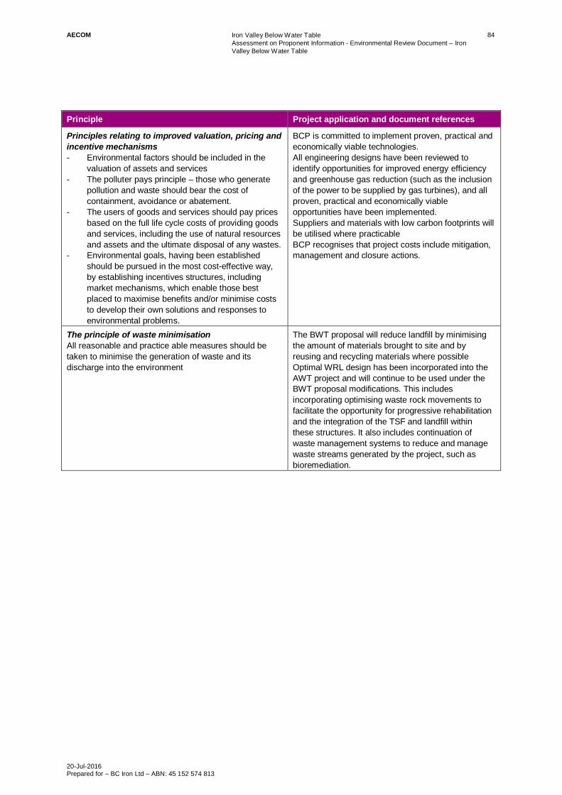
AECOM Iron Valley Below Water TableAssessment on Proponent Information - Environmental Review Document – IronValley Below Water Table
20-Jul-2016Prepared for – BC Iron Ltd – ABN: 45 152 574 813
84
Principle Project application and document references
Principles relating to improved valuation, pricing andincentive mechanisms- Environmental factors should be included in the
valuation of assets and services- The polluter pays principle – those who generate
pollution and waste should bear the cost ofcontainment, avoidance or abatement.
- The users of goods and services should pay pricesbased on the full life cycle costs of providing goodsand services, including the use of natural resourcesand assets and the ultimate disposal of any wastes.
- Environmental goals, having been establishedshould be pursued in the most cost-effective way,by establishing incentives structures, includingmarket mechanisms, which enable those bestplaced to maximise benefits and/or minimise coststo develop their own solutions and responses toenvironmental problems.
BCP is committed to implement proven, practical andeconomically viable technologies.All engineering designs have been reviewed toidentify opportunities for improved energy efficiencyand greenhouse gas reduction (such as the inclusionof the power to be supplied by gas turbines), and allproven, practical and economically viableopportunities have been implemented.Suppliers and materials with low carbon footprints willbe utilised where practicableBCP recognises that project costs include mitigation,management and closure actions.
The principle of waste minimisationAll reasonable and practice able measures should betaken to minimise the generation of waste and itsdischarge into the environment
The BWT proposal will reduce landfill by minimisingthe amount of materials brought to site and byreusing and recycling materials where possibleOptimal WRL design has been incorporated into theAWT project and will continue to be used under theBWT proposal modifications. This includesincorporating optimising waste rock movements tofacilitate the opportunity for progressive rehabilitationand the integration of the TSF and landfill withinthese structures. It also includes continuation ofwaste management systems to reduce and managewaste streams generated by the project, such asbioremediation.

AECOM Iron Valley Below Water TableAssessment on Proponent Information - Environmental Review Document – IronValley Below Water Table
20-Jul-2016Prepared for – BC Iron Ltd – ABN: 45 152 574 813
85
8.0 Conclusions
8.1 Proponents ConclusionBCP is proposing to develop the Iron Valley BWT proposal as an amendment to the existing AWT operations. Theaccess to the BWT resource will extend the life of the operations by approximately 10 years, but significantlyincrease the throughput. The additional components of the operations include beneficiation and the related TSFcells to encapsulate the process waste generated.
Environmentally, the proposal means potential additional pressure is being applied to the surface andgroundwater systems in the vicinity of the tenement, in particular WWC and its connectivity to the groundwateraquifers. The proposal applies temporary and local pressure to the area. This pressure applied by the BWTproposal is minor, but incremental to an already altered baseline ecosystem. This impact assessment has takeninto account future reasonably foreseeable projects in the form of a two scenario assessment; one which dealswith the proposal in isolation, the other which includes hydrological effects in the form of additional discharge fromupstream into WWC.
The findings of the assessment are considered to meet the EPA objectives for each of the limited number ofpreliminary environmental factors considered that were derived in conjunction with key stakeholders andregulators associated with the proposal.
The preliminary key environmental factors assessed in the BWT proposal are:
- Hydrological processes
- Inland waters environmental quality
- Flora and vegetation
- Terrestrial fauna
- Subterranean fauna
- Heritage
- Rehabilitation and closure.
These were similar to the AWT except for three differences.
1. Aquatic fauna was included in the terrestrial fauna factor due to the interactions of the proposal withWWC
2. Stygofauna was expanded and comprehensively investigated to account for new likely changes ingroundwater levels and
3. The flora and vegetation study was extended by including the potential impacts of the proposal on awider extent of groundwater dependent vegetation / riparian vegetation, but also the fluctuating wettingfront across the 10 year life of mine.
Given the good connectivity between groundwater and surface water in the vicinity of WWC, as well as thephysical constraints for space existing on the tenement several project design modifications were applied in aniterative process as potential environmental impacts became known. Some of these include:
- Specific locations for water discharge points to maximise the recovery of the groundwater system. Thisresulted in minimising the drawdown to the extent possible.
- Modification of the pumping rates across the life of mine, to minimise the abrupt changes to water availabilityin the creek system
- Maintaining an exclusion corridor between the ranges and the Creek system, not only for unimpeded waterpassage during flooding, but also providing an access route for conservation significant species using thishabitat.
- Integrating the TSF into the WRL to minimise the surface clearance footprint and
- Back filling pits that would result in a groundwater sinks

AECOM Iron Valley Below Water TableAssessment on Proponent Information - Environmental Review Document – IronValley Below Water Table
20-Jul-2016Prepared for – BC Iron Ltd – ABN: 45 152 574 813
86
In addition to these design measures, management and mitigation has been applied to be consistent with thecurrent AWT operations.
The key and other environmental factors included in this assessment have been assessed against the EPA’sobjectives and relevant guidelines. The proposal has been prepared with design, layout and management controlsidentified to avoid, minimise or manage potential environmental impacts. Given the configuration of the proposalto avoid significant impacts to environmental assets and values, and the existing and proposed managementactions and controls to protect the environment currently being undertaken, the proponent considers that theproposal will meet the EPA’s objectives and is environmentally acceptable.
In conjunction with the conclusions reached in this assessment, as explained above, BCP considers that this ERincludes all content requirements in accordance with EAG 14, and the preparation of an ER consistent withcurrent expectations of an API-A. In accordance with EAG 14, the proposal raises only a limited number of keyenvironmental factors that can be readily managed and for which there is an established condition-settingframework. The proposal is also consistent with established environmental policies, guidelines and standards,which are identified in Appendix H. The proponent, in preparation of the ER has consulted at length with keystakeholders to the project including decision making authorities and has addressed in the assessment,comments raised during the consultation process. It is understood that due to the size of the Iron Valley BWTproposal, any concern regarding its implementation would be limited locally.
8.2 Application of the Significance FrameworkThe Plate below shows a conceptual application of the EPA significance framework. It provides an overview of theproponents view on residual impacts related to the environmental factors addressed in the assessment. Theimpact assessment concludes that the EPA objectives for all factors assessed will be met.
Plate 1 Conceptual Application of the EPA Significance Framework

AECOM Iron Valley Below Water TableAssessment on Proponent Information - Environmental Review Document – IronValley Below Water Table
20-Jul-2016Prepared for – BC Iron Ltd – ABN: 45 152 574 813
87
9.0 ReferencesAMIRA. 2002. ARD Test Handbook. Project 387A. Prediction and Kinetic Control of Acid Mine Drainage. AMIRAInternational. Melbourne, Australia.
ANZECC & ARMCANZ, 2004. Australian and New Zealand Guidelines for Fresh and Marine Water Quality.Australian and New Zealand Environment Conservation Council and Agriculture and Resource ManagementCouncil of Australia and New Zealand. Canberra, ACT.
Beard, JS 1975, Pilbara, The Vegetation of the Pilbara Area: 1:100,000 Vegetation Series. University of W.APress, Perth.
Bruce, R.C. and Rayment, G.E. (1982). Analytical Methods and Interpretations Used by the AgriculturalChemistry Branch for Soil and Land Use Surveys. Queensland Department of Primary Industries Bulletin No.QB2004, Brisbane.
CSIRO Land and Water, 2015. Water Resource Assessment for the Pilbara, A report to the Government ofWestern Australia and industry partners from the CSIRO Pilbara Water Resources Assessment, Don McFarlan(ed), 7 October 2015.
Department of Environment and Conservation. 2010. Contaminated Sites Management Series: AssessmentLevels for Soils, Sediment and Water, Version 4, Revision 1. February. Department of Environment andConservation, Government of Western Australia. Perth WA.
Department of Water, 2011. Managed aquifer recharge in Western Australia, Operational Policy 1.01,Government of Western Australia, January 2011.
Department of Water, 2013a. Western Australian water in mining guideline, Water licensing delivery series reportNo 12, Government of Western Australia, May 2013.
Department of Water. 2013b. Strategic policy 2.09: use of mine dewatering surplus, Government of WesternAustralia, May 2013.
Environmental Protection Authority. 2000. Position Statement 2 Environmental protection of native vegetation inWestern Australia.
Environmental Protection Authority. 2002. Position Statement 3 Terrestrial biological surveys as an element ofbiodiversity protection
Environmental Protection Authority. 2004. Guidance Statement. No. 51. Terrestrial Flora and vegetation forEnvironmental Impact Assessment in Western Australia.
Environmental Protection Authority. 2004b. Position Statement 4 Environmental protection of wetlands.
Environmental Protection Authority. 2004c. Guidance Statement. No. 56. Terrestrial Fauna Surveys forEnvironmental Impact Assessment in Western Australia.
Environmental Protection Authority. 2004d. Guidance for the assessment of environmental factors No. 41 –Assessment of Aboriginal Heritage.
Environmental Protection Authority 2006. Guidance for the assessment of environmental factors No. 6 –Rehabilitation of terrestrial ecosystems
Environmental Protection Authority. 2007 Guidance Statement. No. 54a. sampling methods and surveyconsiderations for subterranean fauna in Western Australia.
Environmental Protection Authority. 2007. Technical Appendix to Guidance Statement No.54. Sampling Methodsand Survey Considerations for Subterranean Fauna in Western Australia.
Environmental Protection Authority. 2009. Guidance Statement. No. 20. Sampling of Short Range EndemicInvertebrate Fauna for Environmental Impact Assessment in Western Australia.
Environmental Protection Authority 2010. Technical Guide - Terrestrial Vertebrate Fauna Surveys forEnvironmental Impact Assessment
Environmental Protection Authority 2011, Environmental Offsets Policy, Western Australia

AECOM Iron Valley Below Water TableAssessment on Proponent Information - Environmental Review Document – IronValley Below Water Table
20-Jul-2016Prepared for – BC Iron Ltd – ABN: 45 152 574 813
88
Environmental Protection Authority. 2012. EAG 1. Environmental Assessment Guideline for Defining the KeyCharacteristics of a Proposal.
Environmental Protection Authority. 2013. Environmental and water assessments relating to mining and mining-related activities in the Fortescue Marsh management area, Report and recommendations of the EnvironmentalProtection Authority, Report 1484, July 2013.
Environmental Protection Authority. 2013b. EAG 9. Environmental Assessment Guideline for Application of asignificance framework in the environmental impact assessment process
Environmental Protection Authority. 2013c. EAG 12. Consideration of subterranean fauna in environmental impactassessment in Western Australia
Environmental Protection Authority. 2014. Cumulative environmental impacts of development in the Pilbara region
Environmental Protection Authority 2014b WA Environmental Offsets Guidelines
Environmental Protection Authority 2014c Environmental Protection Bulletin No.1 – Environmental Offsets.
Environmental Protection Authority. 2015a. EAG 14. Environmental Assessment Guideline for Preparation of anAPI – Category A. Environmental Review Document.
Environmental Protection Authority. 2015b. EAG 8. Environmental Assessment Guideline for Environmentalfactors and objectives.
Environmental Protection Authority. 2015c. EAG 16. Environmental Assessment Guideline for Referral of aproposal under s38 of the Environmental Protection Act 1986
Environmental Protection Authority. 2015d. EAG 17. Environmental Assessment Guideline for the preparation ofmanagement plans under Part IV of the Environmental Protection Act 1986
Environmental Protection Authority. 2015e Environmental Protection Bulletin No. 19 – EPA Involvement in MineClosure
Environmental Protection Authority and the Department of Mines and Petroleum 2015 Guidelines for preparingmine closure plans
Environmental Protection Authority Website, accessed March 2016.http://www.epa.wa.gov.au/Policies_guidelines/Pages/MajorEPAguidancerelatedtoenvironmentalfactor.aspx?cat=Major%20EPA%20guidance%20related%20to%20environmental%20factors&url=Policies_guidelines
Government of Western Australia, (2014). 2014 Statewide Vegetation Statistics incorporating the CAR ReserveAnalysis
Moore, G. 2001. Soil Guide: A Handbook for Understanding and Managing Agricultural Soils.
National Committee on Soil and Terrain. 2009. Australian Soil and Land Survey Field Handbook (3rd Edition).CSIRO Publishing, Collingwood, Victoria.
Pinder et al. 2010. An arid zone awash with diversity: patterns in the distribution of aquatic invertebrates in thePilbara region of Western Australia.
Rio Tinto. 2015. Yandicoogina Iron Ore Project – Revised Proposal. Public Environmental Review. StateAssessment Number.
Rio Tinto. 2015. Yandicoogina Iron Ore Project – Revised Proposal. Public Environmental Review. StateAssessment No. 2017.
Stone, Y., Ahern, C. R. and Blunden, B. 1998. Acid Sulfate Soils Manual 1998. Acid Sulfate Soils AdvisoryCommittee. In. Wollongbar, NSW.