2010 Growing Season - Coffey County, Kansas Land Cover …...Mulch Till Ridge Till Strip Till 2010...
16
Number of Fields Percent of Total Fields Total Acres Percent of Acres ALFALFA - - - - CORN 128 27.4% 4,796.2 25.8% CRP 1 0.2% 32.9 0.2% FALLOW - - - - GRAIN SORGHUM 1 0.2% 17.3 0.1% PASTURE 1 0.2% 23.1 0.1% RANGELAND - - - - SOYBEAN 326 69.8% 13,433.4 72.3% SUDAN GRASS - - - - SUNFLOWER - - - - URBAN/RESIDENTIAL - - - - WHEAT 4 0.9% 167.3 0.9% OTHER (Total) 6 1.3% 100.5 0.5% Food Plot 1 0.2% 8.5 0.0% Red Clover 4 0.9% 81.6 0.4% Unknown 1 1 0.2% 10.4 0.1% TOTAL FIELDS 467 18,570.7 1 Unidentified row crop 2010 Growing Season - Coffey County, Kansas Land Cover Summary
Transcript of 2010 Growing Season - Coffey County, Kansas Land Cover …...Mulch Till Ridge Till Strip Till 2010...

Number of
Fields
Percent of
Total Fields Total Acres
Percent
of Acres
ALFALFA - - - -
CORN 128 27.4% 4,796.2 25.8%
CRP 1 0.2% 32.9 0.2%
FALLOW - - - -
GRAIN SORGHUM 1 0.2% 17.3 0.1%
PASTURE 1 0.2% 23.1 0.1%
RANGELAND - - - -
SOYBEAN 326 69.8% 13,433.4 72.3%
SUDAN GRASS - - - -
SUNFLOWER - - - -
URBAN/RESIDENTIAL - - - -
WHEAT 4 0.9% 167.3 0.9%
OTHER (Total) 6 1.3% 100.5 0.5%
Food Plot 1 0.2% 8.5 0.0%
Red Clover 4 0.9% 81.6 0.4%
Unknown1 1 0.2% 10.4 0.1%
TOTAL FIELDS 467 18,570.7
1Unidentified row crop
2010 Growing Season - Coffey County, Kansas
Land Cover Summary

Number
of Fields
Percent of
Tillage Fields
Total
Acres
Percent of
Tillage Acres
NO TILL 117 25.1% 4,759.0 25.7%
(Greater than 30% Residue)
REDUCED TILL 68 14.6% 2,826.4 15.2%
(15-30% Residue)
CONVENTIONAL TILL 279 59.9% 10,915.4 58.9%
(Less than 15% Residue)
2 0.4% 37.0 0.2%
1 0.2% 26.6 0.1%
- - - -
- - - -
1 0.2% 10.40 0.1%
- - - -
TOTAL 466 18,537.77
TILLAGE FIELDS 466 18,537.8
Mulch Till
Ridge Till
Strip Till
2010 Growing Season - Coffey County, Kansas
Tillage Summary
OTHER METHODS (TOTAL)
Continuous No Till
Burn
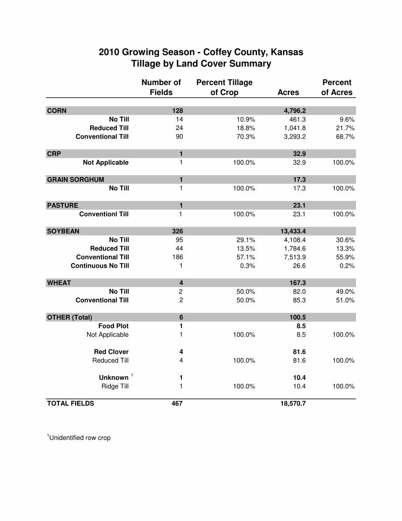
Number of
Fields
Percent Tillage
of Crop Acres
Percent
of Acres
CORN 128 4,796.2
No Till 14 10.9% 461.3 9.6%
Reduced Till 24 18.8% 1,041.8 21.7%
Conventional Till 90 70.3% 3,293.2 68.7%
CRP 1 32.9
Not Applicable 1 100.0% 32.9 100.0%
GRAIN SORGHUM 1 17.3
No Till 1 100.0% 17.3 100.0%
PASTURE 1 23.1
Conventionl Till 1 100.0% 23.1 100.0%
SOYBEAN 326 13,433.4
No Till 95 29.1% 4,108.4 30.6%
Reduced Till 44 13.5% 1,784.6 13.3%
186 57.1% 7,513.9 55.9%
1 0.3% 26.6 0.2%
WHEAT 4 167.3
No Till 2 50.0% 82.0 49.0%
Conventional Till 2 50.0% 85.3 51.0%
OTHER (Total) 6 100.5
Food Plot 1 8.5
Not Applicable 1 100.0% 8.5 100.0%
Red Clover 4 81.6
Reduced Till 4 100.0% 81.6 100.0%
Unknown1
1 10.4
Ridge Till 1 100.0% 10.4 100.0%
TOTAL FIELDS 467 18,570.7
1Unidentified row crop
2010 Growing Season - Coffey County, Kansas
Tillage by Land Cover Summary
Conventional Till
Continuous No Till

Percent Tillage of
Crop Acres Surveyed
Total Acres of
Crop
Planted (FSA)
Estimate of
acres per
crop per
tillage
practice
CORN 33,954.0
No Till 10.9% 3,701.0
Reduced Till 18.8% 6,383.4
Conventional Till 70.3% 23,869.7
GRAIN SORGHUM 1,309.0
No Till 100.0% 1,309.0
SOYBEAN 87,806.0
No Till 29.1% 25,551.5
Reduced Till 13.5% 11,853.8
Conventional Till 57.1% 50,137.2
Continuous No Till 0.3% 263.4
WHEAT 2,733.0
No Till 50.0% 1,366.5
Conventional Till 50.0% 1,366.5
CRP 23,163.0
2010 Growing Season - Coffey County, Kansas
Extrapolation to Entire County Using FSA Acreage

Number of
Fields
Percent of
Practice Acres
Percent
of Acres
TERRACES 465 18,533.4
Greater than 12in 203 43.7% 9,241.8 49.9%
6in to 12in 16 3.4% 530.2 2.9%
Less than 6in 9 1.9% 368.4 2.0%
None 237 51.0% 8,393.0 45.3%
125 5,593.4
Contour Buffers - - - -
Contour Farming 1 0.8% 50.8 0.9%
Double Crop - - - -
Field Buffers 32 25.6% 973.9 17.4%
Filter Strips 1 0.8% 8.2 0.1%
Grass Waterway 85 68.0% 4,200.8 75.1%
Irrigated Field 6 4.8% 359.6 6.4%
TOTAL FIELDS 590.00 24,126.77
WITH PRACTICES2
590 24,126.8
2Some fields may duplicate practices.
2010 Growing Season - Coffey County, Kansas
Practices Summary
BEST MANAGEMENT
PRACTICES (BMPs)

Number
of Fields
Percent of
Assessed Fields
Total
Acres
Percent of
Assessed Acres
CLASSIC GULLY 14 3.0% 929.4 5.0%
EPHEMERAL GULLY 245 52.5% 9,802.8 52.2%
SHEET & RILL 183 39.2% 6,829.7 36.4%
SOIL DEPOSITION 35 7.5% 1,212.2 6.5%
TOTAL FIELDS 477 18,774.1
WITH EROSION CONCERNS3
477 102.1% 18,774.1 101.1%
TOTAL FIELDS ASSESSED 467 18,570.7
3Some fields have duplicate forms of erosion.
2010 Growing Season - Coffey County, Kansas
Erosion Summary

2010 Growing Season Tillage Survey Coffey County - Land CoverLegendLand Cover
CRPCornGrain SorghumOtherPastureSoybeanWheat
RoadsNRI RouteWaterbodies
0 2 4 6 81Miles
Kansas State University Dept. of AgronomyKansas State University Research Extension
2010 Growing Season Tillage SurveyTransect Driven Jun 11 through 29, 2010
Base layers gathered from DASCNAD 1983 UTM Zone 15
July 2, 2010
1:250,000

2010 Growing Season Tillage Survey Coffey County - Tillage MethodLegendTillage Method
No TillReduced TillConventional TillRidge Till
RoadsNRI RouteWaterbodies
0 2 4 6 81Miles
Kansas State University Dept. of AgronomyKansas State University Research Extension
2010 Growing Season Tillage SurveyTransect Driven Jun 11 through 29, 2010
Base layers gathered from DASCNAD 1983 UTM Zone 15
July 2, 2010
1:250,000

2010 Growing Season Tillage Survey Coffey County - Terrace HeightLegend
Terrace Height
Greater than 12in
6in to 12in
Less than 6in
None
Not Applicable
Roads
Waterbodies
0 2 4 6 81
Miles
Kansas State University Dept. of AgronomyKansas State University Research Extension
2010 Growing Season Tillage SurveyTransect Driven Jun 11 through 29, 2010
Base layers gathered from DASCNAD 1983 UTM Zone 15
July 2, 2010
1:250,000

2010 Growing Season Tillage Survey Coffey County - BMPsLegend
Contour Farming
Field Buffer
Filter Strip
Grass Waterway
Irrigated
Roads
Waterbodies
0 2 4 6 81
Miles
Kansas State University Dept. of AgronomyKansas State University Research Extension
2010 Growing Season Tillage SurveyTransect Driven Jun 11 through 29, 2010
Base layers gathered from DASCNAD 1983 UTM Zone 15
July 2, 2010
1:250,000

2010 Growing Season Tillage Survey Coffey County - Visible ErosionLegend
Classic Gully
Ephemeral Gully
Sheet & Rill
Soil Deposition
Roads
Waterbodies
0 2 4 6 81
Miles
Kansas State University Dept. of AgronomyKansas State University Research Extension
2010 Growing Season Tillage SurveyTransect Driven Jun 11 through 29, 2010
Base layers gathered from DASCNAD 1983 UTM Zone 15
July 2, 2010
1:250,000

110702010406
110702040106
110702040102
1107
0204
0203
110702040107
110702010407
102901010302
110702040101
10290101050111
0702
0401
03
110702040105
1107
0201
0401
110702040104110702040204
110702010402
102901010303
1107
0201
0405
102901
010301
110702040202
102901010503
1107
0204
0206
102901010107
2010 Growing Season Tillage Survey Coffey County - Land Cover with HUC 12sLegendLand Cover
CRPCornGrain SorghumOtherPastureSoybeanWheat
Monitoring SitesRoadsWaterbodiesHUC 12s
0 2 4 6 81Miles
Kansas State University Dept. of AgronomyKansas State University Research Extension
2010 Growing Season Tillage SurveyTransect Driven Jun 11 through 29, 2010
Base layers gathered from DASCNAD 1983 UTM Zone 15
December 3, 2010
1:250,000

110702010406
110702040106
110702040102
1107
0204
0203
110702040107
110702010407
102901010302
110702040101
10290101050111
0702
0401
03
110702040105
1107
0201
0401
110702040104110702040204
110702010402
102901010303
1107
0201
0405
102901
010301
110702040202
102901010503
1107
0204
0206
102901010107
2010 Growing Season Tillage Survey Coffey County - Tillage Method with HUC 12sLegendTillage Method
No TillReduced TillConventional TillRidge Till
Monitoring SitesRoadsWaterbodiesHUC 12s
0 2 4 6 81Miles
Kansas State University Dept. of AgronomyKansas State University Research Extension
2010 Growing Season Tillage SurveyTransect Driven Jun 11 through 29, 2010
Base layers gathered from DASCNAD 1983 UTM Zone 15
December 3, 2010
1:250,000

110702010406
110702040106
110702040102
1107
0204
0203
110702040107
110702010407
102901010302
110702040101
10290101050111
0702
0401
03
110702040105
1107
0201
0401
110702040104110702040204
110702010402
102901010303
1107
0201
0405
102901
010301
110702040202
102901010503
1107
0204
0206
102901010107
2010 Growing Season Tillage Survey Coffey County - Terrace Height with HUC 12sLegendTerrace Height
Greater than 12in6in to 12inLess than 6inNoneNot Applicable
Monitoring SitesRoadsWaterbodiesHUC 12s
0 2 4 6 81Miles
Kansas State University Dept. of AgronomyKansas State University Research Extension
2010 Growing Season Tillage SurveyTransect Driven Jun 11 through 29, 2010
Base layers gathered from DASCNAD 1983 UTM Zone 15
December 3, 2010
1:250,000

110702010406
110702040106
110702040102
1107
0204
0203
110702040107
110702010407
102901010302
110702040101
10290101050111
0702
0401
03
110702040105
1107
0201
0401
110702040104110702040204
110702010402
102901010303
1107
0201
0405
102901
010301
110702040202
102901010503
1107
0204
0206
102901010107
2010 Growing Season Tillage Survey Coffey County - Visible Erosion with HUC 12sLegend
Classic GullyEphemeral GullySheet & RillSoil Deposition
Monitoring SitesRoadsWaterbodiesHUC 12s
0 2 4 6 81Miles
Kansas State University Dept. of AgronomyKansas State University Research Extension
2010 Growing Season Tillage SurveyTransect Driven Jun 11 through 29, 2010
Base layers gathered from DASCNAD 1983 UTM Zone 15
December 3, 2010
1:250,000

110702010406
110702040106
110702040102
1107
0204
0203
110702040107
110702010407
102901010302
110702040101
10290101050111
0702
0401
03
110702040105
1107
0201
0401
110702040104110702040204
110702010402
102901010303
1107
0201
0405
102901
010301
110702040202
102901010503
1107
0204
0206
102901010107
2010 Growing Season Tillage Survey Coffey County - BMPs with HUC 12sLegend
Contour FarmingField BufferFilter StripGrass WaterwayIrrigated
Monitoring SitesRoadsWaterbodiesHUC 12s
0 2 4 6 81Miles
Kansas State University Dept. of AgronomyKansas State University Research Extension
2010 Growing Season Tillage SurveyTransect Driven Jun 11 through 29, 2010
Base layers gathered from DASCNAD 1983 UTM Zone 15
December 3, 2010
1:250,000