10578 - BG - Wagga Wagga Hospital Stage 3 - Civil Report ...
32
Page 22 Enviropod
Transcript of 10578 - BG - Wagga Wagga Hospital Stage 3 - Civil Report ...

Page 22
Enviropod
Page 23
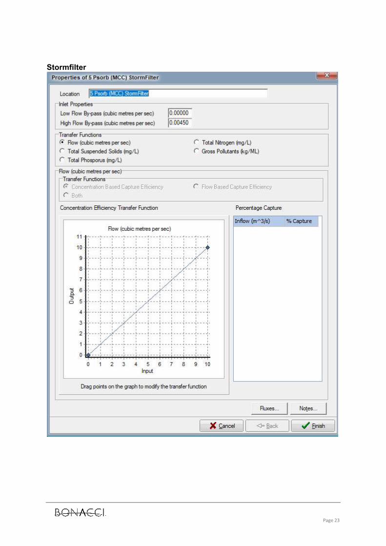
Stormfilter
Page 24

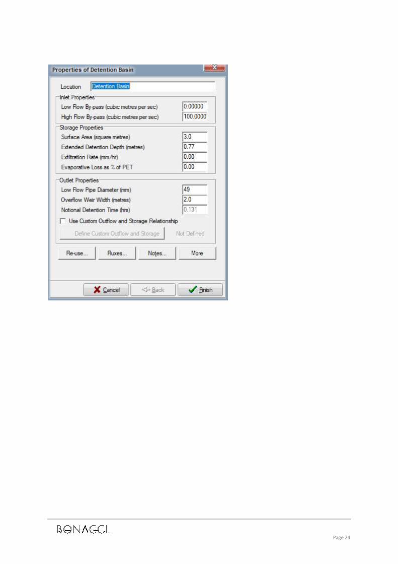
Page 25
Appendix C Wagga Wagga Floodplain Risk Management Plan

MAY 2009
WAGGA WAGGA CITY COUNCIL
WAGGA WAGGA FLOODPLAIN RISK MANAGEMENT PLAN
FINAL

Level 2, 160 Clarence Street Sydney, NSW, 2000 Tel: 9299 2855 Fax: 9262 6208 Email: [email protected] Web: www.wmawater.com.au
WAGGA WAGGA FLOODPLAIN RISK MANAGEMENT PLAN FINAL MAY, 2009 Project WAGGA WAGGAFLOODPLAIN RISK MANAGEMENT PLAN
Project Number 22033
Client Wagga Wagga City Council
Client’s Representative Brad Jeffrey
Authors Erin Askew
Prepared by
Date 1 May 2009
Verified by
Revision Description Date 1 Final MAY 09

WAGGA WAGGAFLOODPLAIN RISK MANAGEMENT PLAN
TABLE OF CONTENTS
1. INTRODUCTION . . . . . . . . . . . . . . . . . . . . . . . . . . . . . . . . . . . . . . . . . . . . . . . 11.1 Floodplain Risk Management Process . . . . . . . . . . . . . . . . . . . . . . . . . . . 1
2. STUDY AREA . . . . . . . . . . . . . . . . . . . . . . . . . . . . . . . . . . . . . . . . . . . . . . . . . 12.1 Description . . . . . . . . . . . . . . . . . . . . . . . . . . . . . . . . . . . . . . . . . . . . . 12.2 Existing Flood Behaviour . . . . . . . . . . . . . . . . . . . . . . . . . . . . . . . . . . . . 12.3 Flood Damages . . . . . . . . . . . . . . . . . . . . . . . . . . . . . . . . . . . . . . . . . . 3
3. ASSESSMENT OF FLOODPLAIN RISK MANAGEMENT MEASURES . . . . . . . . . 53.1 Introduction . . . . . . . . . . . . . . . . . . . . . . . . . . . . . . . . . . . . . . . . . . . . . 53.2 Flood Modification Measures . . . . . . . . . . . . . . . . . . . . . . . . . . . . . . . . . 63.3 Property Modification Measures . . . . . . . . . . . . . . . . . . . . . . . . . . . . . . . 93.4 Response Modification Measures . . . . . . . . . . . . . . . . . . . . . . . . . . . . . 13
4. REFERENCES . . . . . . . . . . . . . . . . . . . . . . . . . . . . . . . . . . . . . . . . . . . . . . . . 17
LIST OF APPENDICES
APPENDIX A: FLOOD POLICY MATRIX
LIST OF TABLES
Table i): Recommended Floodplain Risk Management Measures for Wagga Wagga . . iiTable 1: Flood Events Greater than 10 m . . . . . . . . . . . . . . . . . . . . . . . . . . . . . . . 2Table 2: Selected Design Flood Levels (mAHD) . . . . . . . . . . . . . . . . . . . . . . . . . . . 2Table 3: Total Buildings Inundated . . . . . . . . . . . . . . . . . . . . . . . . . . . . . . . . . . . 4Table 4: Geographical Apportionment of Average Annual Flood Damages . . . . . . . . 4
LIST OF FIGURES
Figure 1: Murrumbidgee River CatchmentFigure 2: Study Area and Location of Major LeveesFigure 3: 1 in 100 ARI Hazard MapFigure 4: PMF Hazard Map

Wagga Wagga Floodplain Risk Management Plan
WMAwater22033:R080317_WaggaFRMP.wpd:2 April, 2009 a
The State Government’s Flood Prone Land Policy is directed at providing solutions to existing
flooding problems in developed areas and to ensuring that new development is compatible with theflood hazard and does not create additional flooding problems in other areas.
Under the Policy, the management of flood liable land remains the responsibility of local
government. The State Government subsidises flood mitigation works to alleviate existing problemsand provides specialist technical advice to assist Councils in the discharge of their floodplain
management responsibilities.
The Policy provides for technical and financial support by the Government through the followingfour sequential stages:
1. Flood Study
• determines the nature and extent of the flood problem.
2. Floodplain Risk Management Study• evaluates management options for the floodplain in respect of both existing and
proposed development.
3. Floodplain Risk Management Plan• involves formal adoption by Council of a plan of management for the floodplain.
4. Implementation of the Plan
• construction or implementation of floodplain risk management measures toprotect existing development,
• use of Local Environmental Plans to ensure new development is compatible withthe flood hazard.
The Wagga Wagga Floodplain Risk Management Plan constitutes the third stage of the
management process. This plan has been prepared by Webb, McKeown & Associates for WaggaWagga City Council and provides the basis for the future management of flood prone lands in the
Murrumbidgee River floodplain around Wagga Wagga.
This plan should be reviewed every two to five years or following any significant flood.
The Wagga Wagga Floodplain Risk Management Plan has been jointly funded by Wagga WaggaCity Council and the Department of Environment and Climate Change.

Wagga Wagga Floodplain Risk Management Plan
WMAwater22033:R080317_WaggaFRMP.wpd:2 April, 2009 i
The Murrumbidgee River is a major tributary of the Murray River system and drains some
100,000 km2 in the southern inland area of New South Wales. The catchment area at the city ofWagga Wagga is some 26,400 km2.
Since early European settlement in the 1840's, the city of Wagga Wagga has experienced flooding
on numerous occasions causing considerable damage and inconvenience. These events haveshaped the past and will continue to shape the future development of the city and the region. The
original settlement of North Wagga Wagga is situated on the northern floodplain but the majorityof the city and recent developments are now located on the high ground of the southern bank.
Industrial development has also occurred on the southern floodplain spreading east from WaggaWagga along the Sturt Highway towards the township of Gumly Gumly and the airport (referred
to as the Eastern Industrial Area).
Estimated records of river levels are available at Hampden Bridge from 1838 to 1886, and officialrecords continue from 1886 to present day. Floods over 10 metres at the Hampden Bridge gauge
were recorded in 1891, 1925, 1950 and 1974. It is likely that flood events in 1844, 1852, 1853 and1870 also exceeded this height. The flood record is extremely variable with five floods occurring
in 1974 and frequent flooding experienced in the period from 1950 to 1956. There have also beenlong periods where no significant flooding has occurred where river levels during floods remained
below 9 metres, such as from 1939 to 1949, 1960 to 1970 and 1992 to 2006.
Wagga Wagga City Council initiated the development of this Plan to address the management ofthe flood problem on the Murrumbidgee River floodplain area around Wagga Wagga. The
development of this Plan completes the third stage of the Floodplain Risk Management Process, with the following reports constituting Stage
1 and 2 respectively:• Wagga Wagga Flood Study (September 2004) and its Addendum (October 2006) which
defined design flood levels, flows and velocities within the floodplain,• Wagga Wagga Floodplain Risk Management Study (July 2007) which categorised the risks
and hazards for the floodplain and also considered the various issues associated withexisting flood affected properties as well as potential future development of the floodplain
by the assessment of various floodplain management options.
Based on the findings of the Wagga Wagga Floodplain Risk Management Study, this Plan sets outthe actions to be adopted for the future management of the Murrumbidgee River floodplain area
around Wagga Wagga. A summary of the management measures recommended forimplementation is presented in Table(i).

Wagga WaggaFloodplain Risk Management Plan
WMAwater22033:R080317_WaggaFRMP.wpd:2 April, 2009 ii
Table i): Recommended Floodplain Risk Management Measures for Wagga Wagga
Measure Recommendation Indicative Costand Benefit
Responsibility
HIGH PRIORITY:
F1: INVESTIGATE THE FEASIBILITYOF RAISING MAIN CITY LEVEE
Within the cost constraints and technical issues associated with raising a levee, a best practicalcompromise should be reached for a level of protection between the 100y ARI plus 0.5m freeboard and100y ARI plus 1.0 m freeboard for concrete wall and earth embankment, respectively. Considerationshould also be given to maintaining a 20y ARI level of protection for the North Wagga Wagga levee. Acost estimate for the levee upgrade is likely to be in the order of $7 -12 Million.
Cost up to $150,000 (eng. &geotechnical study only)Estimated to reduce AAD in thearea by 55%.
Wagga Wagga CityCouncil
F4: IMPLEMENT VEGETATIONMANAGEMENT PLAN FOR PARKENPREGAN LAGOON AND OVERBANKAREAS
From the current results, a 300m maintenance strip would be desired, however, 2D modelling is requiredto assess the full impact of particular maintenance scenarios. Sensitivity of design flood levels tovegetation management plan should be taken into account during the design of the Main City Leveeupgrade.
Approx. $10,000Ensures the management ofregrowth to minimise anypotential hydraulic impacts.
Wagga Wagga CityCouncil
P3: ADOPT APPROPRIATE FLOODPLANNING LEVEL
Adopt a flood planning level which is consistent for different types of development (based on risks) acrossthe floodplain. The Flood Planning Level should incorporate the appropriate design flood level and afreeboard allowance. For Wagga Wagga, a level of 100y ARI plus 0.5m freeboard is recommended forresidential development. The adopted 100y ARI design flood level should be based on the assumptionthat the main city levee will be upgraded.
Cost to developmentAssists in the management offuture development to minimisethe flood-related risk anddamages.
Wagga Wagga CityCouncil
P4: REVIEW AND UPDATE WWCCCURRENT FLOOD POLICY
Formalise Council policy documentation to include findings from this Floodplain Risk ManagementProcess.
$20,000. Assists in themanagement of futuredevelopment to minimise theflood-related risk and damages.
Wagga Wagga CityCouncil
P5: ADOPT A CONSISTENTFREEBOARD OF 0.5 m ABOVE THEDESIGN FLOOD LEVEL
A consistent freeboard of 0.5 m shall apply for all new development within the flood planning area. Cost to developmentAssists in the management offuture development to minimisethe flood-related risk anddamages.
Wagga Wagga CityCouncil
P6: REVIEW AND UPDATESECTION 149 CERTIFICATES
Updated flood information and the floor level survey need to be included on Section 149 certificates. $10,000. Informs residents aboutflood-related developmentcontrols and assists in ensuringfuture development is floodcompatible.
Wagga Wagga CityCouncil
P8: REVIEW AND UPDATE LEP Update the current LEP to incorporate the latest flood terminology and policies. $20,000. Assists in themanagement of futuredevelopment to minimise theflood-related risk and damages.
Wagga Wagga CityCouncil
P9: ADOPT & IMPLEMENTUPDATED DEVELOPMENTCONTROLS FOR FLOOD PRONELAND
Council should adopt and implement a generic Flood DCP with reference to a specific planning matrixtailored to assist with development planning of flood prone lands on the Murrumbidgee River (WaggaWagga) floodplain.
Cost to developmentAssists in the management offuture development to minimisethe flood-related risk anddamages.
Wagga Wagga CityCouncil

Wagga WaggaFloodplain Risk Management Plan
Measure Recommendation Indicative Costand Benefit
Responsibility
WMAwater22033:R080317_WaggaFRMP.wpd:2 April, 2009 iii
R1: CONTINUE TO IMPROVEPUBLIC ACCESS TO FLOODWARNING INFORMATION
Continue to develop and upgrade warning information systems in consultation with BOM and SES. $20,000. Assists in reducing theflood-related damages to thecommunity (both tangible andintangible).
Wagga Wagga CityCouncil, SES and BOM
R2: REVIEW AND UPDATE LOCALFLOOD PLAN
The SES Local Flood Plan should be regularly reviewed and updated. It was last updated September2004. Contents of the Local Flood Plan should be communicated to the community.
$5,000. Ensures that currentbest practice is employed and theapproaches are the mostappropriate.
SES
R4: DEVELOP AND IMPLEMENT AFLOOD EDUCATION PROGRAM
An ongoing Flood Education program will help to maintain/enhance the awareness of the community,particularly, the transient non-permanent “holiday makers”.
$50,000. Assists in reducing theflood-related damages to thecommunity (both tangible andintangible).
Wagga Wagga CityCouncil
R5: OBTAIN MORE DETAILEDTOPOGRAPHIC INFORMATION
More detailed topographic information will allow a more reliable and rigorous foundation for theWaterRIDE program, will increase the accuracy within any future hydraulic modelling and can be used tobetter assess any flood modification measures.
$150,000. Enable more accurateflood information to pe provided.
Wagga Wagga CityCouncil
MEDIUM PRIORITY:F2 & F3: REMOVE THE EASTERNINDUSTRIAL LEVEE PROPOSALFROM COUNCIL’S LONG TERMPLANNING AND CONTINUE WITHCOUNCIL’S CURRENT 20 YEAR ARILEVEL FILLING POLICY.
Levees are a potential means of reducing the flood hazard and damages for existing development. However a similar effect can be achieved without the additional loss of floodplain storage under Council’scurrent filling policy.
$5,000 (to updated Council’s longterm planning). Cost todevelopment. Assisting in themanagement of flood-related riskand damage.
Wagga Wagga CityCouncil
P1: ALLOW HOUSE RAISING FORSUITABLE PROPERTIES
Raising these houses will reduce flood damages but it will not change the hazard categorisation for theproperty. Notification of the eligibility for house raising should be provided on the Section 149 certificate. Council will need to review the suitability of individual houses for house raising.
Approx. $50,000 per property.Reduces /eliminates propertydamage during a flood.
Wagga Wagga CityCouncil
P7: NOTIFY EXISTING PROPERTYOWNERS OF CURRENT S149CERTIFICATE DETAILS
As part of a flood awareness/education program and to ensure all existing property owners are madeaware of any potential flood affectation encoded as a result of this FRMP process, notifications should bemailed to all flood prone property owners, also notifying them of suitable property modification measures.
$5,000. Raises residentawareness and assists in thesuccessful implementation ofdevelopment controls.
Wagga Wagga CityCouncil
R3: MONITOR CHANGES TO THEFLOODPLAIN
Changes to the floodplain (such as filling, new development or re-development) occur on an ongoingbasis. Such changes can alter (increase or decrease) the number of people at risk, the level of risk orevacuation needs and this information may require the Local Flood Plan to be updated.
Nominal. Ensures that the bestavailable information is obtained.
Wagga Wagga CityCouncil
LOW PRIORITY:P2: ALLOW FLOOD PROOFING Flood proofing should be encouraged for existing flood affected buildings, particularly in the
commercial/industrial sectors.Approx. $10,000 per buildingReduces the property damagecaused by flooding
Wagga Wagga CityCouncil

Wagga WaggaFloodplain Risk Management Plan
WMAwater22033:R080317_WaggaFRMP.wpd:2 April, 2009 1
1. INTRODUCTION
The Murrumbidgee River is a major tributary of the Murray River system and drains some100,000 km2 in the southern inland area of NSW. The catchment area at Wagga Wagga is some26,400 km2 (Figure 1). The original settlement of the town was at North Wagga Wagga which issituated on the northern floodplain but the majority of the city and recent developments are nowlocated on the high ground of the southern bank.
The majority of the Murrumbidgee River floodplain in the Wagga Wagga Local Government Areais used for agricultural purposes and contains numerous rural homesteads. There are smallpockets of industrial and urban development in Central and North Wagga. Industrial developmenthas also occurred on the southern floodplain spreading east from Wagga Wagga along the SturtHighway towards the township of Forest Hill and the airport.
1.1 Floodplain Risk Management Process
Wagga Wagga City Council has commissioned the following studies in accordance with theguidelines of the Floodplain Management Manual (Reference 1), which has been recently updatedas the 2005 Floodplain Development Manual (Reference 2):
Stage 1: Flood Study,Stage 2: Floodplain Risk Management Study,Stage 3: Floodplain Risk Management Plan,Stage 4: Implementation of the Plan
The Flood Study (completed in 2004 with an addendum completed in October 2006, Reference 3)analysed all historical flood height data (Table 1) and established the design flood levels for thestudy area with selected values presented in Table 2. The Floodplain Risk Management Study(completed in July 2007, Reference 4) identified the flood problem in terms of risks to floodplainoccupants and their assets, and then canvassed various measures to mitigate the effects offlooding. This Floodplain Risk Management Plan constitutes the third stage and sets out theimplementation program for future management of the floodplain. Wagga Wagga City Council willcomplete the process through implementation of the actions identified in the Plan depending onfinancial, timing and other constraints.

Wagga WaggaFloodplain Risk Management Plan
WMAwater22033:R080317_WaggaFRMP.wpd:2 April, 2009 1
2. STUDY AREA
2.1 Description
This study covers the Murrumbidgee River floodplain area depicted on Figure 2, stretching fromBraehour around 10 km east (upstream) of Wagga Wagga to Kallewanda and the Malebo Rangearound 9 km west (downstream) of Wagga Wagga. A detail map of the study area is provided inFigure 3.
The original settlement was at North Wagga Wagga, which is situated on the northern floodplain.Today, the majority of the city and recent developments are located on the high ground of thesouthern bank. A large part of the city remains on the floodplain and is protected to varyingdegrees from flooding by levee banks, known as the North Wagga Wagga levee and the main citylevee (south).
Hampden Bridge provided the main crossing of the Murrumbidgee River until it was closed andreplaced by the nearby Wiradjuri Bridge. A second crossing has recently been constructed atGobbagombalin. At Hampden Bridge the floodplain is approximately 3 km wide but this reducesto approximately 1.4 km at Gobbagombalin Bridge. Upstream of Wagga Wagga the river iscrossed by the main southern railway and Eunony Road Bridge.
2.2 Existing Flood Behaviour
Official historical flood records for the Hampden Bridge gauge date back to 1886 and are availablefrom Pineena (Reference 5). Prior to this the record is not complete however a compilation of floodheights from 1838 was made by R. J. E. Gormly, a former alderman and resident of the City ofWagga Wagga (Reference 6). Based on these records there have been seven flood events greaterthan 10 metres at the Hampden Bridge as shown in Table 1. Between 1886 and 2005, 76 floods(events separated by at least two days) occurred with peak heights over 8 metres at the HampdenBridge gauge. In recent times the most significant floods (>9.3 mAHD) occurred in 1974, 1975,1976 and 1991 with peak gauge heights of 10.74, 9.58, 9.38 and 9.61 metres respectively.

Wagga WaggaFloodplain Risk Management Plan
WMAwater22033:R080317_WaggaFRMP.wpd:2 April, 2009 2
As part of the Wagga Wagga Flood Study (Reference 3) a rigorous flood frequency analysis of allpast flood records was undertaken to determine the magnitude of the design events. A RUBICONhydraulic (computer) model was established, calibrated to historical data and used to determinedesign flood levels.
Table 1: Flood Events Greater than 10 m
Month Year Gauge Height *June 1852 10.67 (1)
July 1853 11.04 (1)
April 1870 10.67 (2)
June 1891 10.47 (2)
May 1925 10.11 (2)
March 1950 10.06 (2)
August 1974 10.74 (2)
Notes:(1) Source Gormly (Reference 6)(2) Source Pineena (Reference 5)* Gauge zero is equivalent to 170.05 mAHD.Note: The main city levee was constructed following the 1956 flood and subsequently upgraded following the 1974 flood.
Design flood behaviour was established for the 100, 50, 20 and 10 year ARI events and the PMF.The Flood Study provides detailed peak height profiles, design flood contours, flow and velocityinformation. A summary of peak design levels (October 2006 Flood Study update) at key locationsis provided in Table 2. Following the completion of the flood study, two updates were undertakenin light of new information during April 2005 and October 2006. These updates are reported as anAddendum to the Flood Study. Flood levels reported in this plan are based on the most current(October 2006) update.
Table 2: Selected Design Flood Levels (mAHD)
Flood (ARI)Location
10y 20y 50y 100y PMF
Gobbagombalin Bridge 177.8 178.5 179.3 179.9 185.7Narrung Street 179.2 179.8 180.6 181.3 186.1Hampden Bridge 179.3 180.0 180.8 181.4 186.1Railway Bridge 179.9 180.5 181.3 181.9 186.4Gumly Gumly (River) 182.0 182.6 183.2 183.8 188.3Braehour 182.9 183.7 184.5 185.2 189.6
The Flood Study also examined the location and extent of overtopping of the Main City Levee atWagga Wagga. It was determined that the August 1974 flood, previously considered to be a90 year ARI event, is now considered to be a 60 year ARI event. The Main City Levee wasdesigned to provide protection up to the August 1974 event.

Wagga WaggaFloodplain Risk Management Plan
WMAwater22033:R090402_WaggaFMP.wpd:2 April, 2009 3
The Flood Study provides an indicative classification of the hydraulic and hazard characteristics ofthe Murrumbidgee River floodplain for the 100y ARI and PMF events (Figures 3 and 4 respectively).The hydraulic and hazard categories are to be used for assessing the potential suitability of futuretypes of land use and areas of possible development, rather than the assessment of individual orisolated development proposals. For the 100 year ARI, three hazard classifications were definedin the study area:• High hazard floodway - areas where a significant volume of water flows during floods
with high velocities and large depths.• High hazard flood storage - those parts of the floodplains that are important for
temporary storage of floodwaters, floodwaters tend to rise slowly, have low velocities butlarge depths.
• Low hazard flood storage - as for high hazard flood storage except depths and velocitiestend to be less.
2.3 Flood Damages
The assessment of flood damages is an important part of the floodplain risk management process.By quantifying flood damages for a range of design events, appropriate cost effective managementmeasures can be analysed in terms of their benefits (reduction in damages) versus the cost ofimplementation.
The estimation of flood damages tends to focus on the physical impact for the human environmentin the floodplain but there is also a need to consider the ecological costs and benefits associatedwith flooding of the floodplain. Flood damages are often defined as being “tangible” or “intangible”.Tangible damages are those for which a monetary value can be assigned. This is in contrast tointangible damages which cannot easily be attributed a monetary value.
Table 3 presents the total number of buildings inundated for different regions of the study area.Due to the large volume of properties within the Main City Levee, a detailed survey of propertiesinundated during flood events was not undertaken. It is estimated, however, that if the Main CityLevee was to fail or overtop in a major flood event (>50y ARI), the CBD area would be subject toan average flooding depth of 1.4 m over an area of 2.5 km2. This accounts for approximately 2000properties, of which around 75% are residential. This estimation has been used in damagescalculations for the Wagga Wagga CBD.
Additionally, damages have been calculated with assumptions based on DECC formally DNRguidelines (References 16 and 17), that is that the main city and north Wagga levees partially failonce the design height is reached (that is, floods greater than 50y ARI for the main city levee anda 20y ARI for the north Wagga levee).

Wagga WaggaFloodplain Risk Management Plan
WMAwater22033:R090402_WaggaFMP.wpd:2 April, 2009 4
Table 3: Total Buildings Inundated
Area 20y ARI 50y ARI 100y ARI 200y ARI 500y ARIGobbagombalin 13 13 13 13 13Northern Floodplain 1 6 10 12 13Gumly Gumly 7 47 88 92 92East Wagga 22 27 29 32 33North Wagga 91 166 167 167 167Oura 0 11 31 35 36Area within main city levee 0 0 2000+ 2000+ 2000+TOTAL 134 270 >2300 >2350 >2350
The standard way of expressing flood damages is in terms of Average Annual Damages (AAD),that is the total damages experienced by a community over a long period of time converted to anequivalent annual amount. An indication of the average annual damages apportioned to thedifferent areas of existing development in the study area is provided in Table 4.
Table 4: Geographical Apportionment of Average Annual Flood Damages
Area Average Annual Damages Percentage of Total AAD Gobbagombalin $48,300 2.3%Northern Floodplain $12,800 0.6%Gumly Gumly $85,200 4.1%East Wagga $99,000 4.8%North Wagga $381,800 18.5%Oura $29,600 1.4%Area within main city levee (1) $1,406,900 68.2%TOTAL $2.1 million 100%
1. Inundation levels and damages calculations within main city levee are based on estimates only
A new Guideline released by DECC (Reference 15) following completion of the damageassessment above if applied would result in much higher damages than those outlined above. Thenew guideline includes a revised stage-damage curve and assumes flood damage is based on levelof protection rather than floor levels (that is, a freeboard is removed from the surveyed floor level).The second part of the update that is based on level of protection has been applied to the aboveassessment.

Wagga WaggaFloodplain Risk Management Plan
WMAwater22033:R080317_WaggaFRMP.wpd:2 April, 2009 5
3. ASSESSMENT OF FLOODPLAIN RISK MANAGEMENT MEASURES
3.1 Introduction
An assessment of potential floodplain risk management measures was undertaken in the FloodplainRisk Management Study (Reference 4). The measures were assessed against the legal, structural,environmental, social and economic conditions or constraints of the local area. The potentialfloodplain risk management measures can be separated into three broad categories as follows:
• Flood modification measures modify the flood’s physical behaviour (depth, velocity).Typical measures include flood mitigation dams, retarding basins, on-site detention,channel improvements, levees, floodways or catchment treatment.
• Property modification measures modify the existing land use or buildings and developmentcontrols for future development. This is generally accomplished through such means asre-zoning, development control plans, flood access, flood proofing (house raising orsealing entrances), or voluntary purchase.
• Response modification measures modify the community’s response to the potentialhazards of flooding. This is achieved by informing flood-affected property owners as wellas the wider community about the nature of flooding so that they can make better informeddecisions. Examples of such measures include provision of flood warning and emergencyservices, improved information, awareness and education of the community and provisionof flood insurance.
Table i) summarises the management measures recommended as a result of this assessment. The following sections provide a brief discussion of each of the recommended measures(Reference 4 provides details of the complete assessment).

Wagga WaggaFloodplain Risk Management Plan
WMAwater22033:R080317_WaggaFRMP.wpd:2 April, 2009 6
3.2 Flood Modification Measures
F1: Main City Levee
DiscussionThe Main City Levee that surrounds the central business district of the city of Wagga Waggacurrently provides protection for up to the magnitude of the August 1974 flood (estimated as a60y ARI flood - Reference 3). There are a few minor areas along the levee that are slightly belowthis level but these are sandbagged during flood events.
It is proposed that the Main City Levee should be raised to a 100y ARI level of protection andinclude a combination of 0.5 m and 1.0 m allowance for freeboard, depending on the constructiontype. This would provide increased protection to the leveed areas with minimum adverse impactsacross the floodplain. Raising the Main City Levee to the 100y ARI level of protection with anallowance for freeboard will reduce the Annual Average Damages (AAD) for the leveed area by upto 55% of the current estimate of approximately $2.1 million.
There are other issues (besides the level of freeboard) to take into consideration with regard toupgrading the levee, including cost and localised impacts. The final amount of freeboard providedwill be a design parameter based on the type of levee construction and material used.
RecommendationsIt is recommended that the feasibility of raising the Main City Levee to a uniform level of protectionbe investigated further. Within the cost constraints and technical issues associated with raising alevee, a best practical compromise should be reached for a level of protection between the100y ARI plus 0.5 m freeboard and 1.0 m freeboard based on construction and materials used.Consideration should also be given to providing a controlled failure point. Should the 100y ARIlevel of protection not be achieved due to practical constraints, appropriate controls for propertiesbehind the levee will be required.
Consideration should be given to maintaining a 20y ARI level of protection to North Wagga Waggafollowing the levee upgrade and the sensitivity of design flood levels to any floodplain vegetationmanagement plans.
The detailed design stage of the levee upgrade should also give consideration to measures foroffsetting any adverse impacts flooding or otherwise resulting from the upgrade.
ActionsF1: Undertake further detailed investigation of the feasibility of upgrading the Main City Levee
to a 100y ARI level of protection with an appropriate allowance for freeboard.

Wagga WaggaFloodplain Risk Management Plan
WMAwater22033:R080317_WaggaFRMP.wpd:2 April, 2009 7
PriorityHigh
F2 & F3: Eastern Industrial Levee
DiscussionThe majority of Wagga Wagga’s industrial development has occurred on the southern floodplain,spreading east from Wagga to the township of Gumly Gumly. The proposed eastern industrial leveewould surround the areas near Tasman Road, Hammond Avenue and Kooringal Road and wouldprevent the continual disruption of important commercial services. A levee designed for 20y ARIlevel of protection was assessed during the Floodplain Risk Management Study. Another twooptions were also considered, which involved the addition of a finger extension running along theSturt Highway providing 20y and 100y ARI levels of protection.
The proposed location of the eastern industrial levee would result in loss of additional floodplainstorage width compared to development under Council’s current filling policy.
Flood level increases, particularly in Gumly Gumly, and additional lost floodplain storage widthmake any level of protection greater than a 20y ARI unacceptable. The smaller flood level impactsresulting from the 20y ARI levee are likely to occur due to Council’s filling policy which requires onlylocalised filling for developments in this area. However, any protection greater than this results inadverse impacts in larger floods in areas of the floodplain surrounding east Wagga Wagga. Theeffects will also have significant impacts on access and evacuation routes for many residences inthe east Wagga Wagga and Gumly Gumly areas.
RecommendationsThe proposal for a levee providing a 20y ARI level of protection, protecting the eastern industrialarea should be removed from Council’s long term planning as Council’s current filling policy willproduce a similar effect without the additional loss of floodplain storage width. Further the costsof Council’s filling policy will be borne by the landholders who benefit from the filling.
ActionsF2: Remove the eastern industrial levee from Council’s long term planning.F3: Continue Council’s current 20 year ARI level of protection filling policy for development in
the eastern industrial area.
PriorityMedium

Wagga WaggaFloodplain Risk Management Plan
WMAwater22033:R080317_WaggaFRMP.wpd:2 April, 2009 8
F4: Vegetation Management
DiscussionA major concern raised by the Committee and the community was the possibility of thick vegetation(trees) growing on the overbank areas of the Murrumbidgee River in the vicinity of North WaggaWagga impacting on flood levels in all areas. A number of different scenarios and compensatorymeasures were modelled during the Floodplain Risk Management Study, including the use of‘maintenance strips’ to negate the impacts of increased vegetation. As a result of the preliminaryassessment, it was recognised that vegetation needs to be managed, while taking intoconsideration any environmental impacts that may incur.
RecommendationsIt is recommended that the management of regrowth vegetation on the overbank areas be built intoall future floodplain management planning given the significance of potential changes to floodlevels. Based on the current results, a 300 m maintenance strip would be desired, particularly toreduce impacts on North Wagga Wagga associated with excessive vegetation regrowth. However,2D hydraulic (flood) modelling is the only effective means of assessing the full impact of particularmaintenance scenarios. Consideration should be given to the results of this assessment during themain city levee upgrade design. Sensitivity of design flood levels to the vegetation regrowth couldsignificantly affect the crest height required to achieve the 100y ARI level of protection or theamount of freeboard allowance required.
ActionsF4: Implement a vegetation Management Plan for Parken Pregan Lagoon and overbank
areas. Undertake 2D modelling to fully assess the impacts of particular maintenancescenarios and give consideration to these results during the main city levee upgradedesign.
PriorityHigh
Other Flood Modification Measures:
The possibility of raising the North Wagga Wagga levee level of protection was considered duringthe Floodplain Risk Management Study. It was agreed however that it was not appropriate to raisethe level of protection of this levee due to the economic costs and social implications such asreduced flood awareness. It is recommended that the existing levee be maintained to a 20y ARIlevel of protection with an appropriate allowance for freeboard however. Consideration should begiven to the North Wagga Wagga levee during the main city levee upgrade design assessment.Consideration should also be given to the incorporation of a controlled failure point such as aspillway.

Wagga WaggaFloodplain Risk Management Plan
WMAwater22033:R080317_WaggaFRMP.wpd:2 April, 2009 9
3.3 Property Modification Measures
P1: House Raising
DiscussionHouse raising involves lifting an affected house so that the minimum habitable floor level is raisedabove a specified planning level. House raising does not alter or reduce the flood hazard for aproperty and in fact residents will tend to remain within their house rather than be evacuated earlyin an event. The main benefit of house raising is the reduction in flood damages experienced bythe individual property.
RecommendationsHouse raising is a viable measure for those properties satisfying the criteria. Its adoption forimplementation is however dependent on individual resident acceptance and funding availability.An indication of the property’s eligibility for house raising could be recorded on the Section 149Certificate to ensure future potential purchasers are made aware of their options. It must be madeclear that this measure will not completely protect the occupants or the house in large events,evacuation may still be necessary which could pose some hazard or risk. Council will need toreview the suitability of individual houses for house raising.
Commercial stock losses could also be reduced if businesses raised the level of their storage areasor stored stock above the Flood Planning Level.
ActionsP1: Allow house raising for properties satisfying the criteria and add notification to Section 149
certificates.
PriorityMedium
P2: Flood Proofing
DiscussionFlood proofing involves the sealing of entrances, windows, vents etc. to prevent or limit the ingressof floodwaters. An existing house could be sealed whilst new houses and extensions allow theinclusion of flood appropriate materials and design. Additionally, flood proofing can involve theraising of easily damaged/high cost items such as commercial stock, equipment and/or machinery.This method is only suitable for existing buildings as new buildings should have floor levels abovethe Flood Planning Level (FPL) and should be built in a manner which reduces the risk of flooddamage for events greater than the design flood level that forms the basis of the FPL.

Wagga WaggaFloodplain Risk Management Plan
WMAwater22033:R080317_WaggaFRMP.wpd:2 April, 2009 10
This measure is rarely used in NSW for residential buildings and is more suited to commercialpremises where there are only one or two entrances and maintenance and operation procedurescan be better enforced. It will not reduce the flood hazard and in fact the hazard may be increasedif the measure results in occupants staying in their premises and a large flood eventually inundatesthe building to high depths above floor level. There are no other significant environmental or socialproblems associated with this management measure.
RecommendationsThis measure generally costs much less than house raising and it is therefore worthy of furtherdetailed consideration particularly for regularly flooded commercial properties where the damagescan be greater.
A public awareness program should be initiated to inform owners of commercial and residentialproperties about the potential of this measure and allow them to undertake the works at their ownconvenience. It must be made clear that this measure will not completely protect the occupantsor the house in large events, evacuation may still be necessary which could pose some hazard orrisk.
ActionsP2: Inform and educate floodplain occupants about flood proofing measures. Promote flood
proofing of existing affected commercial or industrial developments.PriorityLow
P3, P4 & P5: Flood Planning Level and Flood Policy
DiscussionFlood Planning Levels (FPLs) are an important tool in floodplain risk management. Appendix K ofthe Floodplain Development Manual, 2005 (Reference 2) provides a comprehensive guide to thepurpose and determination of FPLs. The FPL provides a development control measure formeasuring future flood risk and is derived from the combination of a flood event and a freeboard.
Selecting the appropriate FPL for a particular floodplain involves trading off the social and economicbenefits of a reduction in the frequency, inconvenience, damage and risk to life and limb causedby flooding against the social, economic and environmental costs of restricting land use in floodprone areas and of implementing management measures. In considering the suitable FPL forWagga Wagga and the surrounding villages, Council and the Floodplain Risk ManagementCommittee took into consideration the following key development controls:• appropriate development,• flood level,• structural soundness,• flood affectation,• flood evacuation,• management and design.

Wagga WaggaFloodplain Risk Management Plan
WMAwater22033:R080317_WaggaFRMP.wpd:2 April, 2009 11
RecommendationsFollowing assessment of the above development controls for a variety of land use categories, it isrecommended that Council adopt a 100y ARI plus 0.5m freeboard (assuming the main city leveewill be upgraded) as the Flood Planning Level for the overall Murrumbidgee River floodplain. Thislevel is considered to incorporate an appropriate level or balance of risk versus cost to thecommunity for general residential development and is in accordance with accepted standards whichhave been implemented in similar situations throughout NSW.
Variations to the FPL may be adopted for local areas depending on the nature of the developmentand the level of flood risk. A planning matrix which could be adopted to assist in determining FPLscan be found in Appendix A.
Council’s Flood Policy should be updated to include details regarding the FPLs and all otherrelevant information as part of this Floodplain Risk Management Process. Given Council’s currentplanning to limit new development to beyond the 100y ARI extent, Council’s flood policy willessentially better manage the current risk exposure rather than applying to future flood risk.
ActionsP3: Adopt an appropriate Flood Planning Level of 100y ARI plus 0.5 m freeboard, assuming
the main city levee is upgraded.P4: Review and update WWCC Flood Policy.P5: Adopt consistent freeboard of 0.5 m.
PriorityHigh
P6 & P7: Section 149 Certificates
DiscussionSection 149 Planning Certificates provide information on the planning controls and policies thatapply to a particular parcel of land. Currently, Section 149 Planning Certificates in Wagga Waggaare marked simply as “flood affected” where appropriate. There is no standard way of conveyingthe information relating to flood affectation, however the 2005 Floodplain Development Manualprovides a number of examples.
It should be noted that the Section 149 Planning Certificate should not be the only form ofacknowledgment that a property is flood prone. The community should be adequately informedabout the extent of flood prone land and why the flood classification can change from one propertyor area to another. This is particularly relevant for the rural zoned areas of the floodplain.

Wagga WaggaFloodplain Risk Management Plan
WMAwater22033:R080317_WaggaFRMP.wpd:2 April, 2009 12
RecommendationsThe flood affected properties identified by this Study will require their Section 149 PlanningCertificates to be updated as part of the floodplain management process. At the same time, thewording or description included on the certificate should be revised to better describe the floodingimplications and/or planning/building restrictions which may apply as a result of the outcomes fromthe Floodplain Risk Management Study. Details of flood level information should be continuallyupdated as more accurate survey and flood level information becomes available.
A means of appropriately notifying the flood prone rural zoned lands should also be implementedto ensure potential purchasers are fully informed of the flood risks and hazards.
It is also recommended that a public awareness program be developed to inform all flood proneproperties, identified in the Floodplain Risk Management Study, of their current flood affectation andany development constraints imposed by their Section 149 status.
ActionsP6: Review and update Section 149 Certificates. Update and maintain database of floor and
ground levels for all properties, within the floodplain.P7: Notify all existing property owners of the flood affection relating to their property. This
should include the estimated flood levels and planning/development controls or restrictionswhich may apply.
PriorityHigh for P6 and Medium for P7.
P8 & P9: Review And Update LEPs & DCPs
DiscussionClear and up-to-date planning controls are an essential part of the Floodplain Risk ManagementProcess. They ensure that all members of the community are fully aware of what is allowed onflood prone land. The LEP usually specifies the nature of development allowable on any area ofland and whether Council consent is required. A DCP usually applies to a particular issue or localitywhere specific development controls are imposed.
RecommendationsCouncil’s Local Environment Plans (LEP 1991, RLEP 1991 and various related DevelopmentControl Plans) were reviewed as part of the Floodplain Risk Management Process. The relevantplans should now be updated to incorporate the latest terminologies and approach to controllingdevelopment within the floodplain.

Wagga WaggaFloodplain Risk Management Plan
WMAwater22033:R080317_WaggaFRMP.wpd:2 April, 2009 13
The update should reference and incorporate the development controls identified for the WaggaWagga floodplain as part of the Floodplain Risk Management Study (Reference 4). The proposedplanning matrix included in Appendix A demonstrates the potential interaction of developmentcategories with applicable controls/requirements and relevant Flood Planning Levels. It isrecommended that Council adopt the planning matrix presented in Appendix A for application to theparticular characteristics and issues associated with development on the Wagga Wagga floodplain.
ActionsP8: Review and update LEP to incorporate latest flood terminology and policies.P9: Adopt and implement updated development controls for flood prone land.
PriorityHigh
3.4 Response Modification Measures
R1: Flood Warning
DiscussionFlood warning, and the implementation of evacuation procedures by the State Emergency Services(SES), are widely used throughout NSW to reduce flood damages and protect lives. The Bureauof Meteorology (BOM) is responsible for flood warnings on major river systems. The local SES alsohas their own system for monitoring Murrumbidgee River heights, which are clearly identified in theWagga Wagga Local Flood Plan (Reference 7).
The SES Wagga Wagga Local Flood Plan endeavours to provide a comprehensive system of floodwarning and intelligence communication. The SES monitor local gauges in times of flood andmaintain a database of flood intelligence records to assist in providing the community with the bestpossible flood warnings. There is also a network of SES flood wardens, who are communitymembers on the Murrumbidgee River who regularly report on flood levels and effects.
RecommendationsThe Wagga Wagga SES has developed a comprehensive flood warning (and evacuation) plan thatis detailed further in the Wagga Wagga Local Flood Plan. The group are highly motivated andcommitted to providing the most up-to-date information and ongoing education on flooding, floodwarning, flood risk and evacuation planning to the surrounding community. However, it should benoted that the bigger the events, the greater the uncertainty in accurately predicting the peak andtiming of flood events, and hence safe evacuation time required.

Wagga WaggaFloodplain Risk Management Plan
WMAwater22033:R080317_WaggaFRMP.wpd:2 April, 2009 14
ActionsR1: Continue to develop and upgrade warning information systems in consultation with BOM
and SES.
PriorityHigh
R2 & R3: Review And Update Local Flood Plan And Monitor Changes tothe Floodplain
DiscussionA comprehensive Local Flood Plan was prepared by the SES in September 2004 as a sub-plan ofthe Wagga Wagga Local Disaster Plan.
In small and moderate floods in areas surrounding the town, most people will evacuate in a calmand orderly manner, due primarily to their experience and high flood awareness. The level ofawareness in the CBD itself is relatively low and of significant concern, should the main CBD arearequire evacuation. The SES and Council should focus on educating the property owners in thisarea on the evacuation procedures.
RecommendationsThe local Flood Plan should be reviewed and updated to include surveyed floor level informationand flood affection produced as part of the Floodplain Risk Management Study. A workshop shouldbe held to update the SES, Police, Fire Services and other authorities to ensure that all relevantflood response authorities are fully informed of the flood hazard and extent of flood affectation.
The current SES Flood Plan is scheduled for review no later than September 2009. It is standardpolicy to review a plan in the aftermath of an actual flood event where direct lessons may be learntfrom the implementation of the Plan to real life situations.
The majority of information required to updated the local Flood Plan has already been madeavailable as part of the Floodplain Risk Management Process. Additional information on thechanges to the floodplain will need to be compiled.
ActionsR2: Review and update the Flood Plan based on the latest available information.
Communicate the contents of the Flood Plan to the community.R3: Monitor changes to the floodplain and their potential implications for the Local Flood Plan.
PriorityHigh for R2 and Medium for R3.

Wagga WaggaFloodplain Risk Management Plan
WMAwater22033:R080317_WaggaFRMP.wpd:2 April, 2009 15
R4: Flood Awareness and Preparedness
DiscussionA community with high flood awareness will suffer less damage and disruption during and after aflood because people are aware of the potential situation and listen carefully to official warnings onthe radio and television. The level of trauma or anxiety may be reduced as people have “survived”previous floods and know how to handle both the immediate emergency and the post floodrehabilitation phase in a calm and efficient manner.
In Wagga Wagga, the community outside the main city area is very aware of the risk and dangersassociated with flooding, particularly in areas such as North Wagga Wagga and Gumly Gumly. TheSES has a strong presence in the community, and flood education events are held to help maintainthe level of awareness throughout the community.
The level of flood awareness for residents and businesses in the area protected by the Main CityLevee is significantly lower than the rest of the community. This is primarily due to the sense ofsecurity that landholders in this area feel due to the presence of the levee. It is imperative that theimpacts that may occur, were the levee to fail, be communicated to residents in this area.
RecommendationsAs discussed earlier in R1, R2 and R3, the Wagga Wagga SES has developed a comprehensiveflood warning and evacuation plan that is detailed further in the Wagga Wagga Local Flood Plan(Reference 7). The group are committed to providing ongoing education on flooding, the potentialflood risks and evacuation planning to the surrounding community. Table 10 in the Wagga WaggaFloodplain Risk Management Study (Reference 4) provides examples of possible further educationmethods that may be developed and supported by Council.
ActionsR4: Develop and implement an ongoing flood education program.
PriorityHigh

Wagga WaggaFloodplain Risk Management Plan
WMAwater22033:R080317_WaggaFRMP.wpd:2 April, 2009 16
R5: More Detailed Topographic Information
DiscussionIn order to fully assess the impacts of a number of the proposed management options individualdetailed assessment is required. The current RUBICON model does not have sufficient detail tofully assess these options. The acquisition of detailed topographic information such as ALS(Airborne Laser Survey) would benefit the investigation and development of these measures.
RecommendationsIt is recommended that more detailed topographic information of the floodplain be acquired andincorporated into future flooding assessments as well as the WaterRIDE program.
ActionsR5: Obtain more detailed topographic information.
PriorityHigh

Wagga WaggaFloodplain Risk Management Plan
WMAwater22033:R080317_WaggaFRMP.wpd:2 April, 2009 17
4. REFERENCES
1. NSW State GovernmentFloodplain Management Manual (2001)January 2001.
2. NSW State GovernmentFloodplain Development Manual (2005)April 2005.
3. Wagga Wagga City CouncilMurrumbidgee River Wagga Wagga Flood StudyWebb, McKeown & Associates, September 2004
4. Wagga Wagga City CouncilMurrumbidgee River Wagga Wagga Floodplain Risk Management StudyWebb, McKeown & Associates Pty Ltd, August 2007.
5. Department of Land & Water ConservationPineena, Version 6 - NSW Surface Water Data ArchiveApprox. 1999
6. R J E Gormly61 Floods at Wagga WaggaUndated
7. State Emergency ServicesWagga Local Flood PlanSES, September 2004 Edition


FIG
UR
E1
MU
RR
UM
BID
GE
ER
IVE
RC
AT
CH
ME
NT
FILE > J:\JOBS\22033\FIGURES\FIG 1.CDR DATE > NOVEMBER 2003
0 50 100
Kilometres
Lach
lan
River
MurrumbidgeeRiver
GRIFFITH
LEETON
NARRANDERA
WAGGA WAGGA
GUNDAGAI
TUMUT
COOMA
CANBERRA
YASS
BALRANALD
LakeUrana
Study Area
Murrumbidgee RiverCatchment
Murray
River
Murru
mbid
gee
Riv
er
Goodra
dig
bee
Riv
er
Yass
Riv
er
Tum
utR
iver
Yanco Cre
ekACT
Burrinjuck Dam
Tantangora Dam
Blowering Dam
HAY
Sydney

STUDY AREA AND LOCATION OF MAJOR LEVEESFIGURE 2
0 1 2 3 40.5Km
±
Main City Levee
Sturt Highway
Gumly Gumly Levee
East Street/Mill Street Levee
North Wagga Wagga Levee
Gobbagombalin Bridge
Hampden and Wiradjuri Bridges
City of Wagga Wagga
Murrumbidgee River
Railway Line
Braehour
Kallewanda
Malebo Range
Kurrajong Lagoon Levees
Gobbagombalin Weir
Gobbagombalin Levee
LegendFloodplainAreas
Eastern Industrial Area
Gumly Gumly
North Wagga Wagga
Northern Rural Floodplain
Wagga Wagga CBD
Forest Hill
Marshalls Creek