Vulnerability, Risk Reduction, and Adaptation to Climate...
16
! ( ! ( ! ( ! ( ! ( ! ( ! ( ! ( ! ( ! ( ! ( ! ( ! ( Kathmandu Kathmandu Ilam Ilam Jumla Jumla Sallyan Sallyan Baglung Baglung Pokhara Pokhara Bhairawa Bhairawa Rajbiraj Rajbiraj Dhangarhi Dhangarhi Nepalganj Nepalganj Bhimphedi Bhimphedi Ramechhap Ramechhap Biratnagar Biratnagar Dandeldhura Dandeldhura Key to Map Symbols Capital City/Town Major Road River Lake meters above sea-level 7088 m -416 m Elevation N 0 150 300 75 Kilometers Climate Risk and Adaptation Country Profile April 2011 CLIMATE ADAPTATION DISASTER RISK REDUCTION NEPAL Vulnerability, Risk Reduction, and Adaptation to Climate Change ENV Team Climate Change Climate Investment Funds
Transcript of Vulnerability, Risk Reduction, and Adaptation to Climate...

!(!(
!(
!(
!( !(
!(
!(!(!(
!(
!(!(
KathmanduKathmandu
IlamIlam
JumlaJumla
SallyanSallyanBaglungBaglung
PokharaPokhara
BhairawaBhairawa
RajbirajRajbiraj
DhangarhiDhangarhi
NepalganjNepalganj
BhimphediBhimphedi
RamechhapRamechhap
BiratnagarBiratnagar
DandeldhuraDandeldhura
Key to Map SymbolsCapitalCity/TownMajor Road
River
Lake
meters above sea-level7088 m
-416 m
Elevation
N
0 150 30075 Kilometers
Climate Risk and Adaptation Country Profile April 2011
CLIMATE
ADAPTATIONDISASTER
RISKREDUCTION NEPAL
Vulnerability, Risk Reduction, and Adaptation to
Climate Change
E N VTeam
Climate ChangeClimate
Investment Funds

2
Climate Risk and Adaptation Country Profile NEPAL
COUNTRY OVERVIEW
Nepal is a landlocked, mountainous country located in the Himalayas between India and China in South Asia. The terrain is generally mountainous and contains many of the world’s highest peaks, including Mount Everest (8848 m). However, there are also low-lying areas at elevations less than 100 m. The country is divided into five geographic regions, each with a distinct climate and culture. With only 12-15% of the population living in and around urban centers, the country’s 23 million inhabitants live primarily in rural areas (~690 people per km2). Small-scale, subsistence agriculture is the mainstay of Nepal’s economy, employing 78% of the country’s workforce. Water and forests are Nepal’s most abundant natural resources, with freshwater here (derived from glaciers, snowmelt, and rainfall) accounting for 2.27% of the total world supply. This water feeds the country’s major rivers: Koshi, Gandaki, and Kamali; together, these river systems supply freshwater to a large portion of the 500 million people who live in the Ganges river basin. Any changes in the length and intensity of precipitation will not only impact snow cover and glacial density, but also affect these downstream populations.
Nepal’s varied topography and social vulnerability make the country particularly susceptible to geological and climate-related disasters. A general lack of effective response mechanisms and strategies for dealing with natural disasters exacerbates this vulnerability. An increase in soil erosion, landslides, flash floods, and droughts has been reported in recent years across the country, with increased intensity and impact on the lives and livelihoods of the Nepalese. Erratic weather patterns projected in climate models may exacerbate these problems in years to come. High-resource dependent livelihoods are the norm in Nepal, and socio-economic data, including low literacy rates (53%), hunger (30-40% of the Nepalese suffered from hunger in 2007), and widespread poverty levels in rural areas all point to a limited capacity to adequately address future climate change risks.
PRIORITY ADAPTATION MEASURES
According to Nepal’s First National Communication to the United Nations Framework Convention on Climate Change, published in 2004, the country’s most vulnerable sectors are water resources, public health, and terrestrial ecosystems. Nepal has implemented and is designing a suite of active policies to address the underlying causes of vulnerability in the country, including addressing issues of food security, poverty reduction, and, more recently, environmental degradation.
CLIMATE BASELINE AND CLIMATE FUTURE
CLIMATE BASELINE
Nepal’s climate is as diverse as the country’s topography, which encompasses eight of the ten highest mountains in the world and extends to the rim of the Gangetic plains that have elevations below 300 meters above msl. Rainfall in Nepal is driven by the monsoons, which migrate through the country in
Key Sectors
Water Resources
Public Health
Terrestrial Ecosystems
Source: Nepal’s First National Communication to the UNFCCC, 2004.

3
Climate Risk and Adaptation Country Profile NEPAL
the summer months (between June and September) and bring 250-450 mm of rainfall each month to a majority of the country (except for the north-western mountains that receive between 100-150 mm per month). Winters are largely dry in Nepal. Average annual temperature for the whole country is 27°C and average rainfall is 1900 mm annually. However, these statistics vary by region and altitude. The country’s principal climatic regions1 span a rich topography that range in elevation from 100 to 8848 meters in a north-south trajectory of only 80 km and include the following:
Terai plains, a gently sloping region on the rim of the Gangetic plains encompassing elevations below 300 meters with humid tropical climates and average temperatures of 30°C in the summer and 10-15°C in the winter.
Siwalik hills, a zone covering all areas between 300-1500 meters above sea level of steeply sloped and heavily vegetated weak consolidated bedrock, with a moist tropical climate and average annual temperatures of 25°C.
Middle Mountains, a temperate zone with average annual temperatures of 20°C, at elevations of 1000-2500 m.
High Mountains, a cool, sub-alpine zone located between 2200 and 4000 meters above sea level and with average summer temperatures of 5-15°C and winter temperatures below 0°C. This area includes the Himalayan chain and inner valleys (with shallow and resistant to weathering soils).
High Himalayas, an alpine to arctic zone higher than 4000 meters above sea level, with average annual temperatures of <0 to 5°C. Soils in the high Himalayas are composed primarily of limestone shale and subject to physical weathering.
RECENT CLIMATE TRENDS
Climate baseline summary for Nepal (since 1960)2:
There is some debate about whether average annual temperatures in Nepal have risen since 1960. According to Shrestha et al. (1999), Dhakal (2003), and Liuand Chen (2000)3, temperatures between 1977 and 1994 rose between 0.5°C-0.6°C per decade, particularly in the northern mountains, while McSweeney et al.4 suggest that temperatures between 1960 and 2003 decreased slightly during the warm and dry season (March-May).
Mean rainfall has significantly decreased on an average of 3.7 mm (-3.2%) per month per decade, and this decrease is particularly significant during the monsoon period between June-September.
The frequency of cold days and nights (defined as the temperature below which 10% of days or nights are recorded in the current climate of that region or season) per year has decreased significantly, by 5% and 8%, respectively.
1 Country Study Team–Nepal, 1997. “Climate Change Vulnerability and Adaptation: Nepal Water Resources”, prepared as part of the US Country Studies Program, Washington, DC. 2 Source: IPCC 4th Assessment Report and UNDP Climate Profiles. 3 Dhakal S., 2003. One World South Asia. 2003. 4 McSweeney, C., M. New, and G. Lizcano. UNDP Nepal Climate Change Country Profile.

4
Climate Risk and Adaptation Country Profile NEPAL
Glacial melt—The Himalayan glaciers are an important, renewable water source, feeding all of
the country’s rivers. Rising temperatures in the north of the country could increase the rate of glacial melt and increase the risks from GLOFs(Glacial Lake Outburst Floods).
Figure 1: Mean annual temperature (above) and precipitation (below) in Nepal5
5 ww.worldclim.org/The WorldCliminterpolated climate layers were made using tHE FOLLOWING:* Major climate databases compiled by the Global Historical Climatology Network (GHCN), the FAO, the WMO, the International Center for Tropical Agriculture (CIAT), R-HYdronet, and a number of additional minor databases for Australia, New Zealand, the Nordic European Countries, Ecuador, Peru, AND Bolivia, among others.

5
Climate Risk and Adaptation Country Profile NEPAL
Figure 2: Projected changes in rainfall in Western Nepal from the control period of 1980-1999 to 2020-2039 (left) and 2080-2100 (right) across 15 Global Circulation Models.
CLIMATE FUTURE
Climate change summary for Nepal6:
Mean annual temperatures are projected to increase between 1.3-3.8°C by the 2060s and 1.8-5.8°C by the 2090s, and this warming is expected to occur more rapidly during the dry months (December-May).
Winters are projected to be drier and monsoon summers wetter, with some estimating a three-fold increase in monsoon rainfall. This could result in more frequent summer floods and winter droughts.
Currently, it is not possible to get a clear picture of precipitation change, due to large model uncertainties. However, increases in rainfall are more consistent for south-east Nepal.
The impact of climate change on Nepal’s water resources is unclear due to the uncertain behavior of glaciers. However, glacier retreat will occur after an increase in temperature—according to some estimates, roughly 20% of glacier mass could be lost with a 1°C increase in temperature. These projections, however, are still subject to debate.
6 Source: World Bank Climate Change Knowledge Portal. http://sdwebx.worldbank.org
6
Climate Risk and Adaptation Country Profile NEPAL
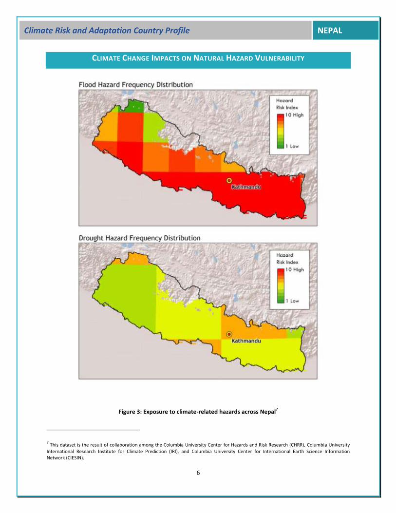
CLIMATE CHANGE IMPACTS ON NATURAL HAZARD VULNERABILITY
Figure 3: Exposure to climate-related hazards across Nepal7
7 This dataset is the result of collaboration among the Columbia University Center for Hazards and Risk Research (CHRR), Columbia University
International Research Institute for Climate Prediction (IRI), and Columbia University Center for International Earth Science Information Network (CIESIN).

7
Climate Risk and Adaptation Country Profile NEPAL
AT A GLANCE
Nepal’s diverse geo-climatic system, which combines heavy monsoons, steep terrain, and remoteness, renders the country vulnerable to natural disasters. The impact of disasters is pronounced in marginal populations, who are already hampered by poverty and disempowerment. Among the most important climate-related disasters in Nepal are the following:
Floods—Together with landslides, floods in Nepal caused an average annual loss of US $14.7 million between 2001 and 2007. These events are triggered by rapid snow and ice melt in the mountains as well as by extreme, torrential rainfall episodes in the foothills during the monsoon season (June-September). One of the most disastrous flood events in Nepal occurred in 1993, when torrential rains in the Terai plains and the hills that feed them triggered dangerous landslides, affecting over 70,000 people and killing over 1,000. Threats also include Glacial Lake Outburst Floods (GLOFS), which cause significant damage in the affected areas. Once such a GLOF event occurred when the Kawari glacial lake burst in 2003, destroying property and livelihoods along the foothills of Annapurna II. Another example is the 1985 GLOF, which brought a 10-15 meter high surge of water and debris on the Bhote Koshi and Dudh Koshi rivers, destroying homes and critical infrastructure along its path. It is estimated that 26 potentially dangerous glacial lakes exist in Nepal. Of these, the most dangerous is considered to be the Tsho Rolpa lake (elevation 4580 m), which feeds the Rolwaling River in the Tama Koshi basin north of Katmandu. A recent UNEP study suggested reducing the Tsho Rolpa lake levels by at least 20 meters to reduce the danger it poses8. Throughout Nepal, the number of casualties from floods and related landsides has increased, with 1,314 lives lost between 2000 and 20059.
Landslides—As noted above, landslides are triggered by rapid snow and ice melt in the mountains as well as by extreme, torrential rainfall episodes in the foothills during the monsoon season (June-September). Landslides threaten the safety and economy of hill communities by destroying homes and blocking critical infrastructure10. A case in point were the landslides experienced in August 2006, which slowed aid deliveries to more remote areas by making critical road networks impassable. Lack of accessibility in already vulnerable areas and unstable terrain make landslides particularly dangerous. Furthermore, landslides reduce both available
8 ICIMOD, Glacial Lakes and Associated Floods in the Hindu Kush, Himalayas. Information Sheet #2/10. 9 CBS, 2006: Environmental Statistics of Nepal, Kathmandu, Nepal, 2006. 10 UN Common Country Report for Nepal 2007.
Table 1: Illustrative impacts of GLOFs since 1981 in Nepal
Date Glacial Lake Impacts
11 July 1981 Zhangzagbo (Boqui) lake in Tibet
Significant damages to Sun Koshi Hydro-electric project, bridges along the Arniko highway destroyed, $3million in damages.
4 August 1985 Dig Tsho, in Khumbul Himal
Destroyed the nearly completed Namche Sall Hydell Project, extensive damage downstream.
7 October 1994
Luggetsho (upstream of Punakha Dzong in Bhutan)
Flash floods on PhoChhu river with extensive material damage and loss of life.

8
Climate Risk and Adaptation Country Profile NEPAL
agricultural land and agricultural productivity, thus increasing the vulnerability of already fragile populations.
Droughts—Droughts are becoming more frequent occurrences in Nepal, particularly during the winter months and in the western Terai plains, which are already characteristically quite dry because of the late arrival of the monsoons. In 2006-2007, when monsoon rainfalls fell to 16% below normal, the following months of drier conditions reduced rice cultivation by 21-30%. Droughts are also risk factors for hydropower generation in the country, particularly in relation to minimum-flow requirements during drought years.
Waterborne diseases—According to the UN’s 2007 Common Country Assessment for Nepal, epidemics such as cholera and diarrhea (diseases manifested from poor water quality) take the largest human toll in Nepal every year. These are compounded by a lack of health facilities and medicine, widespread poverty, and a common lack of hygiene awareness.
SECTORAL CLIMATE RISK REDUCTION RECOMMENDATIONS
Climate variability and change have and will continue to affect Nepal in ways as diverse as the country’s topography. Vulnerability is a key factor that needs to be considered to identify the differential impacts of climate. The poor have limited access to resources and few income-generating opportunities, and their living conditions are often affected by laws, policies, and economic forces over which they have little or no control. Although it is by no means clear whether vulnerable groups (with their pressures to survive) or affluent groups (with their pressures to consume) ultimately lead to the impacts that continue to drive vulnerability, it does seem clear that poor people will not, and cannot, meet the Millennium Development Goals if it requires looking beyond their immediate needs. The most profound impacts of climate variability and change in Nepal will be felt in the sectors discussed below: agriculture and food security, water resources, public health, and energy.
AGRICULTURE, LIVESTOCK, AND FOOD SECURITY
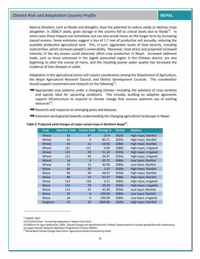
Agriculture provides much needed sustenance to the country’s predominantly rural population, and climate changes are projected to have significant impacts on these farming systems. Reduced water availability during dry periods could exacerbate agricultural water needs, as an estimated 64% of the country’s farmers rely on water from rains of the monsoons. Planting and harvesting seasons have been slowly changing in Nepal, due to the shifting monsoon, and these shifts are likely to become more erratic under a changing climate. Crop yields of major cereals in Nepal are projected to decrease substantially (see Table 1). Over 80% of Nepal’s managed water is used for irrigation11 and 38% of the country’s agricultural land is irrigated. Even high-input, irrigated wheat, maize, and sorghum yields show significant decreases in northwest Nepal under a changing climate in the 2020s, -51.24%, -30.7%, and -25.93%, respectively. Projected rainfall decreases during the winter could impact winter and spring yields, while projected temperature increases are likely to reduce maize and wheat yields.
11 Raksakulthai, 2003. Nepal: Climate Change Vulnerability and Adaptation. Asian Disaster Preparedness Center, presented at the NAPA workshop, Thimpu, Bhutan, 9-11 September 2003.
9
Climate Risk and Adaptation Country Profile NEPAL
Natural disasters, such as floods and droughts, have the potential to reduce yields or destroy crops altogether. In 2006/7 alone, grain storage in the country fell to critical levels due to floods12. In some cases these impacts are immediate, but can also wreak havoc on the longer term by increasing topsoil erosion. Some estimates suggest a loss of 1.7 mm of productive soil annually, reducing the available productive agricultural land. This, in turn, aggravates issues of food security, including malnutrition, which increases people’s vulnerability. Moreover, heat stress and projected increased intensity of the dry season could adversely affect crop production in Nepal. Increased sediment loads, such as those witnessed in the Jegedi watershed region in the Chitwan district, are also beginning to alter the course of rivers, and the resulting poorer water quality has increased the incidence of liver diseases in cattle.
Adaptation in the agricultural sector will require coordination among the Department of Agriculture, the Nepal Agricultural Research Council, and District Development Councils. This coordination should support investment and research on the following13:
Appropriate crop patterns under a changing climate—including the selection of crop varieties and species ideal for upcoming conditions. This includes building an adaptive agronomic support infrastructure to respond to climate change that ensures optimum use of existing resources14.
Research and response on emerging pests and diseases.
Extension work geared towards understanding the changing agricultural landscape in Nepal.
Table 2: Projected yield changes of major cereal crops in Northern Nepal15
.
Crop Baseline Yield Future Yield Change % Period Options
Wheat 63 47 -25.4 2020s High Input, Rainfed
Wheat 63 9 -85.71 2050s High Input, Rainfed
Wheat 63 51 -19.05 2080s High Input, Rainfed
Wheat 121 121 0.00 2080s High Input, Irrigated
Wheat 121 59 -51.24 2020s High Input, Irrigated
Wheat 121 89 -26.45 2050s High Input, Irrigated
Wheat 14 9 -35.71 2080s Low Input, Rainfed
Wheat 20 12 -40.00 2080s Low Input, Rainfed
Maize 89 92 3.37 2020s High Input, Rainfed
Maize 89 48 -46.07 2050s High Input, Rainfed
Maize 89 52 -41.57 2080s High Input, Rainfed
Maize 114 118 3.51 2080s High Input, Irrigated
Maize 114 79 -30.70 2020s High Input, Irrigated
Maize 114 65 -42.98 2050s Low Input, Rainfed
Maize 25 0 -100.00 2080s Low Input, Rainfed
Maize 26 0 -100.00 2080s Low Input, Irrigated
Sorghum 23 29 2609.00 2020s High Input, Rainfed
12 UNWFP, 2007. 13 Practical Action. Promoting Adaptation in Nepal, Policy Brief. 14 Platform for Agro-biodiversity, 2009. Climate Change and Agrobiodiversity in Nepal: Opportunities to include agrobiodiversity maintenance to support Nepal’s National Adaptation Programme of Action (NAPA). 15 World Bank Climate Change Data Portal –Agricultural Model Generated by IIASA.

10
Climate Risk and Adaptation Country Profile NEPAL
Crop Baseline Yield Future Yield Change % Period Options
Sorghum 23 18 -21.74 2050s High Input, Rainfed
Sorghum 23 16 -30.43 2080s High Input, Rainfed
Sorghum 27 28 3.70 2080s High Input, Irrigated
Sorghum 27 20 -25.93 2020s High Input, Irrigated
Sorghum 27 16 -40.74 2050s Low Input, Rainfed
Sorghum 5 0 -100.00 2080s Low Input, Rainfed
Sorghum 4 0 -100.00 2080s Low Input, Irrigated
WATER RESOURCES
Nepal’s water resources are extensive; however, projected reductions in winter snows could reduce available snowmelt levels during spring and summer. Also, increased temperatures could result in greater winter runoff. The behavior of Himalayan glaciers under a changing climate (particularly a climate with higher temperatures) is still a subject of debate, but increased melting will in the long term reduce the country’s water supply, rendering many of the country’s irrigated lands vulnerable. Glacial lake outburst floods (GLOFs) also threaten the country’s water resources, contributing significantly to river sedimentation and thus impacting hydropower generation. The country’s current water management plan posits a significant effort in increasing the country’s irrigated lands, hydropower generation, and domestic water supply. All of these goals should be viewed through a climate variability and change lens in order to avoid mal-adaptation.
In spite of the extensive water resources in the country, poor and inadequate management infrastructure have reduced water quality, particularly in the country’s urban areas, where the population continues to increase at a rate of 5% annually. Water stress and scarcity are now commonplace in Katmandu, and these issues will be exacerbated under a changing climate. Adaptation mechanisms in the water sector should:
Promote water conservation and market-based water allocation.
Increase irrigation efficiency and expand the country’s irrigation and storage capacity.
Mitigate GLOF risks through pumping, building drainage channels, and implementing downstream flood control measures.
PUBLIC HEALTH
Nepal‘s public health sector is vulnerable to climate variability and change, particularly with regard to the increased incidences of nutritional deficiencies, diarrheal, and vector-borne diseases. In 2006, Dengue, Aedes aegypti, previously unrecorded in Nepal, was reported in major urban areas of the Terai, which border India. In 2009, Aedes aegypti Dengue was first reported in Katmandu, and the presence of these diseases has significant ties to a changing climate16. Recent evidence also indicates an elevation migration of the Anopheles fluviatilis malaria vector above elevations of 1500 m, and the number of endemic malaria districts across Nepal has increased from 13 to 52 in recent
16 Gautam I, Dhimal M, Shretha SR, Tamrakar AS. First Record of Aedes Aegypti (L.) Vector of Dengue Virus from Kathmandu, Nepal. Journal of Natural History Museum. 2009:24;156-64.

11
Climate Risk and Adaptation Country Profile NEPAL
years17. Diarrheal diseases are already a significant problem in Nepal, and flooding may exacerbate these and other water quality diseases (such as cholera), by increasing surface water pollution. Addressing the impacts of climate variability and change on the health sector requires addressing issues of poverty, sanitation, nutrition, and environmental degradation, all of which significantly hamper communities’ vulnerability and capacity to adapt. Adaptation recommendations in the health sector include18:
Strengthening the country’s health services—paying particular attention to increasing the system’s rapid response capacity with regards to diseases that have a direct climate link, including monitoring and raising awareness. Increased coordination among the country’s health sector with broader developmental players will ensure that the health concerns related to climate change are mainstreamed into development activities.
Promoting research on climate change and health—there is an urgent need to understand and attribute the health impacts of climate change in Nepal, especially for vulnerable locations.
Securing local drinking water supplies and proper drainage is an essential step towards curbing diseases of water quality19.
ENERGY
In spite of the fact that 78% of the country’s current energy use is derived from fuel wood, Nepal’s hydropower generation potential is significant (noted as 86 GW by Shrestha et al. 1985). Of this, 32% is estimated to be the direct result of glacial melt, with the other 68% coming from monsoon rains. Nepal’s hydropower potential is a function of average flow and vertical drop available, and as noted, the country’s rich topographic diversity encompasses all elevations between 100 and 8848 meters in a north-south trajectory of only 80 km. Micro-hydropower schemes have been planned to complement the country’s development goals, particularly in remote, rural areas. From a climate variability and change perspective, however, hydropower schemes are vulnerable to changes in climate, as projected future warming may change glacial melt availability both due to reduced glacial extent and to increased evapotranspiration. Flows on glacier-fed rivers are first likely to increase as warming occurs and more water is released from glaciers. However, as glaciers begin to recede, less water is available as a source of melt, thus reducing the flow amount. One author suggests that a .06ºC/year warming will first increase Nepal’s hydropower potential (~5.7% by 2030), but this will likely lead to decreases in the later part of the century on the order of 25%. Building a climate-resilient hydropower infrastructure will require significant adaptation in the sector to increased runoff and variability, as well as increased reservoir evaporation and sedimentation. Managing water resources and addressing the damaging risks of floods in general should be a priority in the energy sector.
17 Narain JP. Climate Change and Its Potential Impact on Vector Borne Diseases. Health in South East Asia June 2008 Issue. WHO SEARO; 2008;14. 18 Dhimal, M. and Bhusal, CL. 2009. Impacts of Climate Change on Human Health and Adaptation Strategies in Nepal. J Nepal Health Res Counc 2009 Oct;7(15):140-141. 19 Practical Action. Promoting Adaptation in Nepal, Policy Brief.

12
Climate Risk and Adaptation Country Profile NEPAL
EXISTING ADAPTATION FRAMEWORK/STRATEGY/POLICY AND INSTITUTIONAL SETUP
AT A GLANCE
Nepal has made considerable gains in integrating environmental issues into development plans since the 1980s, including the establishment of a Ministry of Environment in 1990, requiring environmental impact assessments (EIAs), and the implementation of a National Environmental Protection Act, which defines impact standards. Progress in integrating climate change into these frameworks, however, is a relatively recent priority and much work is required to address the potentially harmful impacts of climate change across the country. Adapting to climate risks in the disaster management sector of Nepal will require both a coordinated national planning structure, as well as local and community-level response measures. Several initiatives are already underway to address these issues (see below), but additional efforts are required, as outlined in the National Strategy for Disaster Risk Management, along with five priority actions:
Ensuring that disaster risk reduction is a national and local priority with a strong institutional basis for implementation.
Identifying, assessing, and monitoring disaster risks and strengthening early warning systems.
Improving knowledge management for building a culture of safety and resilience.
Reducing the underlying risk factors.
Enhancing preparedness for effective responses.
Specific efforts aimed at addressing these pillars are outlined below.
Ongoing Efforts—At a Glance
Vulnerability Reduction Description of Project Donor/Agency
Nepal Risk Reduction Consortium
A Consortium of ADB, IFRC, UNDP, UNOCHA, UNISDR, and World Bank was formed in May 2009 to support the Government of Nepal in developing a Disaster Risk Reduction Action Plan building on the National Strategy for Disaster Risk Management (NSDRM). The Nepal Risk Reduction Consortium initiated consultations with key stakeholders to identify disaster risk reduction priorities that are both urgent and viable. Consortium members and government developed a draft program proposal that identified five flagship areas. Consortium members act as coordinators for these flagship areas.
ADB, IFRC, UNDP, UNOCHA, UNISDR, and World Bank
Rural energy projects (REDP and KiND)
REDP and KiND improve rural livelihoods and conduct children’s studies, and remove the wood-collecting burden from women and smoky wood-burning stoves from their homes to improve air quality and lessen reliance on greenhouse gas-emitting and forest-depleting sources of energy.
UNDP

13
Climate Risk and Adaptation Country Profile NEPAL
GEF Small Grants Programme (SGP)
Most SGP projects contribute to the environmental sustainability and to reducing carbon emissions. Many have also improved rural livelihoods and the economic situation of rural people
GEP Small Grants
Conservation and Sustainable Use of Wetlands (CSUWN)
This project conserves the biodiversity of Nepal’s wetlands by building sustainable environmentally-benign livelihoods for the many poor people who rely on and live around these areas.
Mitigating the effects of climate change (NAPA and ECCCA)
Climate change is likely to increase hunger and poverty in developing countries such as Nepal by reducing food production, by causing more natural disasters (to which the poor tend to be most vulnerable), and by causing malaria to spread. These two projects are helping identify and implement measures to mitigate these potential threats.
Disaster risk reduction projects (DRRN and ERRRP)
The vulnerability of many of Nepal’s poor to natural disasters is a large impediment to the achievement of the MDGs. It is the poor and marginalized people who tend to live on steep landslide-prone slopes, on low-lying flood-prone areas, and in flimsy dwellings that collapse during earthquakes, and who have the least resources to recover. These projects are mainstreaming disaster risk reduction into planning across sectors and making buildings more earthquake-resilient.
UNDP, AusAID, EC, OCHA, WB, ADB, IFRCRC,OCHA, and UNDP
Glacial Lake Outburst Flood (GLOF) risk reduction project for the Himalayas
Assessed the impact of a GLOC on two of Nepal's most threatened areas and explored non-structural measures to reduce the risks from GLOFs.
UNDP/EC
Koshi Early Recovery Project (KERP)
UNDP’s coordination of early recovery work and assistance to rebuild livelihoods is helping prevent the victims of the 2008 Koshi floods from sinking into poverty.
UNDP
INSTITUTIONAL AND POLICY GAPS
Making the shift from reactively responding to climate hazards to a more proactive, risk reduction approach requires a significant change in current disaster programming and monitoring in Nepal. One important element in this regard is the establishment of a National Emergency Operation Center. This center opened in 2010, but significant investments will be required to enhance and augment its capacity for monitoring and responding to climate change risks. Learning should be central to the center’s capacity-building initiative, in particular from the experience of similar centers across the world: for example, Mozambique’s National Disaster Management (INGC) Institute.
Mainstreaming climate variability and change into national policy and planning processes is yet to be achieved in Nepal. The government’s current five year plan, as well as the Medium-Term Expenditure Framework (the latter of which was developed to ensure appropriate allocation to different sectors) focus on poverty reduction but lack explicit consideration of climate change risks and suggestions for possible responses.
Development responses that address unique cultural and environmental diversity, as well as its long-term sustainability while reducing vulnerability are lacking for the Himalayan region. By some accounts, the Nepalese government’s long-term development policy for the Himalayas

14
Climate Risk and Adaptation Country Profile NEPAL
lacked grounding in the realities of this sensitive zone, which contains large glaciers, seasonal and perennial snows, and wetlands and peat. As a result, traditional systems of development and construction were replaced by approaches that make the region more vulnerable. For example, dynamite used in mining for cement has been reported to increase the threat of landslides by weakening existing rock structures. The realities and weaknesses of government and local agencies, including remoteness, lack of coordination, and inappropriate response in the Himalayan region have left a large gap between official responses and community requirements.
Engagement of stakeholders at both local and national levels in decision making and the identification of options for addressing climate change risks is required—as is a significant investment in raising public awareness on issues of climate change, which in Nepal is generally low due to limited communication channels and lack of materials available in the requisite local languages. Awareness of climate change and the direct involvement of communities in workshops, meetings, and activities where the identification of adaptation options is conducted is a key pillar in responding to climate change risks.
Appropriate response mechanisms, from a national agency to village-level early warning systems and emergency response capacity, are lacking in all but a few places in Nepal. These systems should be implemented, particularly in the areas vulnerable to GLOFs under a changing climate.
Accountability is lacking under Nepal’s current environmental regulations, as are appropriate monitoring systems to deal with potentially vulnerable populations.
Poor coordination among stakeholders responsible for climate risk management and environmental projection is commonplace across the country. Issues of coordination must be addressed in order to build a system of knowledge transfer within and across organizations and respond proactively and effectively to climate risks, both now and in the future.
The number of trained disaster managers at the central and field levels is inadequate to deal with disaster risks and should be significantly augmented.
RESEARCH, DATA, AND INFORMATION GAPS
Though it remains difficult to pin particular disasters such as floods and storms to the phenomenon of climate change, it is clear that a destabilized climate system, together with other forms of environmental damage, will continue to negatively impact Nepal. Climate change is not just about average values, but rather a matter of extremes. The predicted increases in maximum and minimum temperatures for South Asia, coupled with reduced winter rainfall and increased precipitation during the summer monsoons is likely to render disasters more frequent and severe. Droughts in the winter and floods in the summers, coupled with thawing of perennial snow and ice in the high elevations may further limit already stressed communities. Additional research, data, and information gaps to be addressed in this regard are listed below.
15
Climate Risk and Adaptation Country Profile NEPAL
RESEARCH GAPS
The following research measures could be supportive in reducing the impact of climate change:
Developing a contextually relevant plan (for both the Himalayan and Plains regions) to address natural disasters in these unique and fragile environments requires significant research on current coping strategies, vulnerabilities, and adaptation options (for the Himalayas in particular), rather than applying universal strategies that may not be appropriate for different areas.
Mainstreaming disaster risk management into planning and administration, particularly in a geo-climatically diverse environment such as Nepal, requires further research on appropriate mechanisms for mainstreaming at the administrative level, including studies on the differential effects of climate variability and change on disaster vulnerability, and increased glacial melting and shifting rainfall patterns.
DATA AND INFORMATION GAPS
Meeting the required capacity to respond to climate variability should be grounded in an understanding of the diverse populations and ecosystems of the country, particularly those most vulnerable. Among the most important data and information gaps are the following:
Collection of more disaggregated data by geography, income group, gender, and ethnic group on the effects of natural disasters to gauge their relative impact and for planning purposes.
Improving observation and forecasting in existing climate prediction mechanisms and introduction of appropriate early warning and crop forecasting systems where appropriate.
Map hazards and vulnerabilities—highlighting the location of specific hotspots in the country where climate-related hazards are experienced or likely to be felt is a key step in identifying intervention areas. Risks vary over time and space (even over relatively short distances)—this reflects both the changing probability of the risk occurring and the changing scale of consequence when and if the risk occurs. Proper documentation of existing risks is a critical first step towards understanding the underlying dynamics that lead to disasters. Mapping exercises should document the current hazards, use socio-economic information to characterize the vulnerability of the areas exposed to these hazards, and identify the projected changing dynamics of these hazards in light of changes in climate.

NEPAL
Climate Risk and Adaptation Country Profile
© 2011 THE WORLD BANK GROUP1818 H Street, NWWashington, DC 20433Internet: www.worldbank.orgContact: Milen Dyoulgerov, [email protected]
All rights reserved.
This volume is a product of the World Bank Group. The World Bank Group does not guarantee the accuracy of the data in-cluded in this work. The boundaries, colors, denominations, and other information shown on any map in this work do not imply any judgement on the part of the World Bank Group concerning the legal status of any territory or the endorsement or acceptance of such boundaries.
This Country Profile (http://countryadaptationprofiles.gfdrr.org) is part of a series of 49 priority country briefs developed by the Global Facility for Disaster Reduction and Recovery (GFDRR) and the Global Support Program of the Climate Investment Funds (CIF). The profile synthesizes most relevant data and information for Disaster Risk Reduction and Adaptation to Climate Change and is designed as a quick reference source for development practitioners to better integrate climate resilience in development planning and operations. Sources on climate and climate-related information are linked through the country profile’s online dashboard, which is periodically updated to reflect the most recent publicly available climate analysis.
Acknowledgments: The Country Profiles were produced through a partnership between the Global Facility for Disaster Reduction and Recovery, the Global Support Program of the Climate Investment Funds, and the Climate Change Team of the Environment Department of the World Bank, by a joint task team led by Milen Dyoulgerov (TTL), Ana Bucher (co-TTL), Fernanda Zermoglio, and Claudio Forner. Additional support was provided by Sarah Antos, Michael Swain, Carina Bachofen, Fareeha Iqbal, Iretomiwa Olatunji, Francesca Fusaro, Marilia Magalhaes, Habiba Gitay, Laura-Susan Shuford, Catherine Nakalembe, Manisha Ganeshan, Roshani Dangi, Anupam Anand and Li Xu. IT, GIS, and map production support was provided by Varuna Somaweera, Katie McWilliams, and Alex Stoicof from the Sustain-able Development Network Information Systems Unit (SDNIS). Jim Cantrell provided design. The team is grateful for all comments and suggestions received from the regional and country specialists on disaster risk management and climate change.
E N VTeam
Climate ChangeClimate
Investment Funds