VILLAGE OF NORTHBROOK
16
DEVELOPMENT AND PLANNING SERVICES DEPARTMENT Page 1 MEMORANDUM VILLAGE OF NORTHBROOK TO: RICHARD A. NAHRSTADT, VILLAGE MANAGER FROM: MICHAELA KOHLSTEDT, SENIOR PLANNER DATE: DECEMBER 8, 2015 SUBJECT: PCD-15-04 –1230 VOLTZ ROAD – PLANNED DEVELOPMENT INTRODUCTION On December 8, 2015, the Planning & Zoning Committee will review the revised plans for the Anets Woods planned development, a 34-unit detached single family residential development. This is an application submitted by Edward R. James Partners, LLC, (the “Applicant”) as contract purchaser of the property at 1220 and 1230 Voltz Road (the “Subject Property”) which is owned in trust by Anets Family, LLC (the “Owner”). On August 11, 2015 the Plan Commission recommendation was presented to the Board of Trustees during which time the Board identified some reservations with the plan and directed the item to the Planning & Zoning Committee for further discussion, which occurred on October 20, 2015 and is summarized below. Since the October 20 meeting, the Applicant has met with neighbors and has revised the proposed plan to address comments from Village Trustees and members of the public. OCTOBER 20 PLANNING & ZONING COMMITTEE MEETING SUMMARY & APPLICANT’S RESPONSE On October 20, the Planning & Zoning Committee held a meeting to discuss the proposed Anets Wood planned development. In addition to Committee members Trustee Karagianis, Buehler, and Heller being present, Trustees Scolaro and Israel were also present (for the purpose of this memo we refer to all of those present as “the Committee”). The Committee heard a presentation from the Applicant, heard comments from members of the public, and then discussed the application (the staff report and minutes of that meeting are attached for reference). The Applicant had presented a slightly revised plan from what the Plan Commission reviewed. The revised plan reduced the number of homes from 36 to 34 and included a reconfigured interior road system with a cul-de-sac and restricted connection to Lee Road to the north. The revised plan also incorporated several off-site modifications which remain part of the Applicant’s current request and are discussed later in this report. During the meeting several members of the public spoke primarily of concerns with the proposed development. Some of the concerns raised by members of the public included a need for a discussion between the Applicant and the neighbors to the north of the development (something the Applicant had done with neighbors along Voltz Road), ongoing concerns with the traffic impact the development would have along Voltz Road as well as the traffic impacts along Lee Road if the connection north to Lee was made a through connection. Since the October 20 meeting, staff has received a number of written comments from residents of the area outlining concerns varying from traffic to density, as well as some correspondence supporting the proposed development. All of the correspondence which has been received since October 20 is attached for consideration. After hearing from the public, the Committee members discussed the proposed development and asked the Applicant to address a number of items. Below is a summary of the comments from the Committee, followed by a statement indicating how the Applicant has since addressed the concerns (see
Transcript of VILLAGE OF NORTHBROOK

DEVELOPMENT AND PLANNING SERVICES DEPARTMENT
Page 1
MEMORANDUM VILLAGE OF NORTHBROOK
TO: RICHARD A. NAHRSTADT, VILLAGE MANAGER
FROM: MICHAELA KOHLSTEDT, SENIOR PLANNER
DATE: DECEMBER 8, 2015
SUBJECT: PCD-15-04 –1230 VOLTZ ROAD – PLANNED DEVELOPMENT
INTRODUCTION On December 8, 2015, the Planning & Zoning Committee will review the revised plans for the Anets Woods planned development, a 34-unit detached single family residential development. This is an application submitted by Edward R. James Partners, LLC, (the “Applicant”) as contract purchaser of the property at 1220 and 1230 Voltz Road (the “Subject Property”) which is owned in trust by Anets Family, LLC (the “Owner”). On August 11, 2015 the Plan Commission recommendation was presented to the Board of Trustees during which time the Board identified some reservations with the plan and directed the item to the Planning & Zoning Committee for further discussion, which occurred on October 20, 2015 and is summarized below. Since the October 20 meeting, the Applicant has met with neighbors and has revised the proposed plan to address comments from Village Trustees and members of the public. OCTOBER 20 PLANNING & ZONING COMMITTEE MEETING SUMMARY & APPLICANT’S RESPONSE On October 20, the Planning & Zoning Committee held a meeting to discuss the proposed Anets Wood planned development. In addition to Committee members Trustee Karagianis, Buehler, and Heller being present, Trustees Scolaro and Israel were also present (for the purpose of this memo we refer to all of those present as “the Committee”). The Committee heard a presentation from the Applicant, heard comments from members of the public, and then discussed the application (the staff report and minutes of that meeting are attached for reference). The Applicant had presented a slightly revised plan from what the Plan Commission reviewed. The revised plan reduced the number of homes from 36 to 34 and included a reconfigured interior road system with a cul-de-sac and restricted connection to Lee Road to the north. The revised plan also incorporated several off-site modifications which remain part of the Applicant’s current request and are discussed later in this report. During the meeting several members of the public spoke primarily of concerns with the proposed development. Some of the concerns raised by members of the public included a need for a discussion between the Applicant and the neighbors to the north of the development (something the Applicant had done with neighbors along Voltz Road), ongoing concerns with the traffic impact the development would have along Voltz Road as well as the traffic impacts along Lee Road if the connection north to Lee was made a through connection. Since the October 20 meeting, staff has received a number of written comments from residents of the area outlining concerns varying from traffic to density, as well as some correspondence supporting the proposed development. All of the correspondence which has been received since October 20 is attached for consideration. After hearing from the public, the Committee members discussed the proposed development and asked the Applicant to address a number of items. Below is a summary of the comments from the Committee, followed by a statement indicating how the Applicant has since addressed the concerns (see

Page 2
the attached narrative and updated traffic study submitted by the Applicant). In addition, staff has worked with the Village’s traffic consultant to address some of the concerns expressed by the Committee. Information and findings from Village staff and the Village’s traffic consultant, which is included in the attached memo from the Village’s consultant, are also noted below. Work With Neighbors
Planning & Zoning Committee Comments: Committee members requested that the Applicant continue to work with the neighbors to try to address the neighbors’ concerns; specifically the neighbors to the north of the Subject Property.
Applicant Response: The Applicant states in their attached narrative that they met with the neighbors to the north twice since the October 20 meeting. One of the concerns raised by the neighbors to the north was the proximity of the proposed homes to the existing homes along Country Lane.
The Applicant has increased the setback along the northern property line from 40’ to 45’ for the proposed homes and allows some decks to be up to 40’ from the northern property line. To accommodate the increased setback, the Applicant reduced the width of park area in the center of the development by 5’. Along with this increase in the rear setback to the north, the Applicant has also increased the landscape buffer along the northern property line. Both of these modifications, which are shown below, are discussed in more detail with additional visuals in the material submitted by the Applicant.
Figure 1: Development along the North Property Line
Staff Commentary: With the increase of the building setback from 40’ to 45’, the proposed rear setback for the structures would exceed the minimum district requirement of 40’ for the R-4 Single Family Residential District. The Applicant is also maintaining a minimum separation of 25’ between the homes along the northern property line, which also exceeds the district minimum separation of 18’.
Traffic Impacts on Lee Road
Planning & Zoning Committee Comments: Committee members had yet to reach a consensus as to whether Lee Road should connect to the street within the proposed development as a through street or as a restricted access connection for only emergency vehicles and residents of the development. However, the trustees did state they did not favor restricting access on a public street.
Applicant Response: The Applicant now proposes to make a small portion of the roadway within development that connects north to Lee Road a private street with a controlled access gate for residents and emergency personnel only. The below image shows the area where the proposed

Page 3
road would be private to accommodate the restricted access gate without having a restricted access located on a public street. The rest of the street network within the development would be public streets. The Applicant has provided a more detailed description of the proposed restricted access, as well as additional information in the updated traffic study that has been submitted with their narrative. In summary, the Applicant believes that the restricted access will alleviate the amount of traffic from the development utilizing Voltz Road, while not creating a cut-through traffic scenario along Lee Road to the north had the connection been made an open public connection.
Figure 2: Proposed Connection of Development's Street Network with Lee Road
Staff Commentary: In regards to the connection to Lee Road, the Village traffic consultant has reviewed the impact that making a full public access connection to Lee Road would have on the area to the north. The Village traffic consult has concluded connecting Lee Road to the Anets Woods development as a through street would lead to an increase in cut-through traffic from Dundee Road to Voltz Road/Waukegan Road. The report states that there is already sufficient access in the area with use of Lee Road connecting to Walters Avenue to Waukegan Road and Lee Road connecting to Grant Road to Voltz Road.
Figure 3: Street System in Surrounding Area
Page 4
The material submitted by the Applicant concurs with this decision and, as noted above, the proposed plan incorporates restricted access north to Lee Road for residents and emergency vehicles only. Village staff members that reviewed the Village traffic consultant’s memo also agree that a through street connection from Lee Road south to Voltz Road does not seem necessary, as long as access for emergency vehicles is provided.
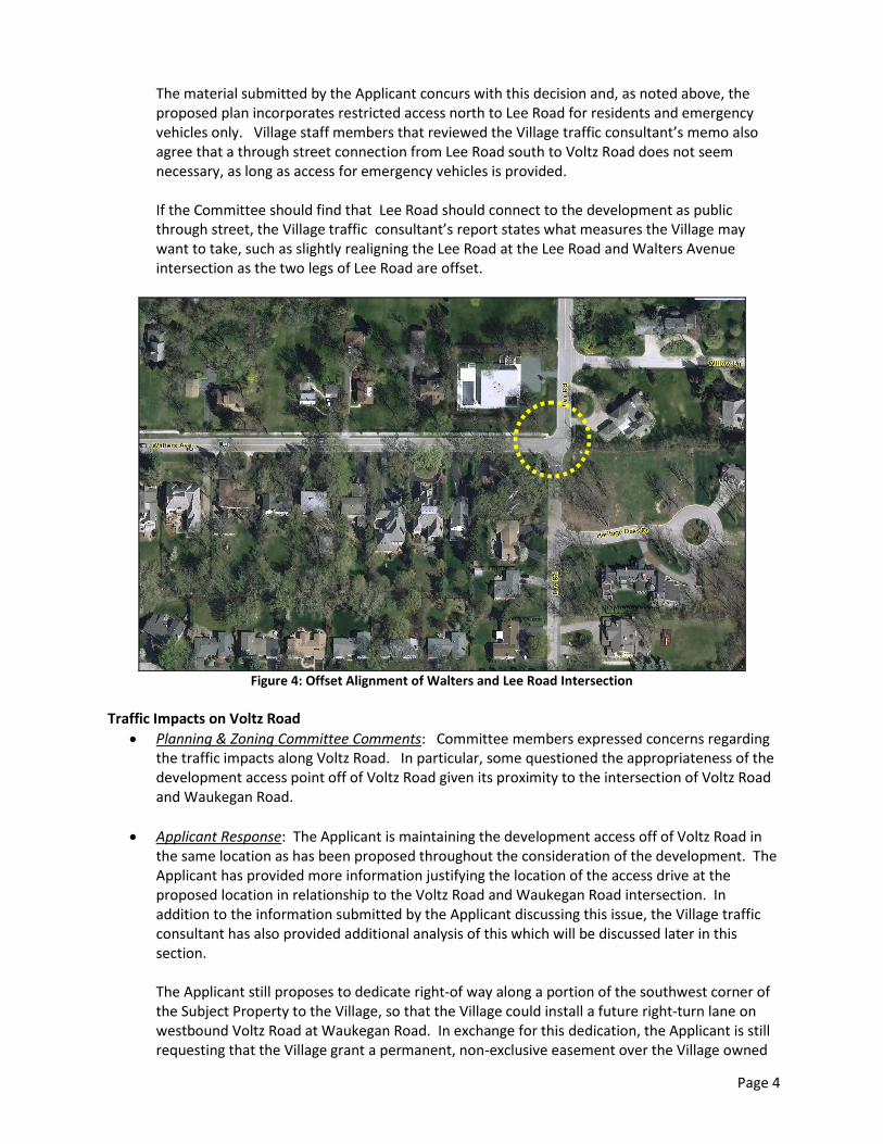
If the Committee should find that Lee Road should connect to the development as public through street, the Village traffic consultant’s report states what measures the Village may want to take, such as slightly realigning the Lee Road at the Lee Road and Walters Avenue intersection as the two legs of Lee Road are offset.
Figure 4: Offset Alignment of Walters and Lee Road Intersection
Traffic Impacts on Voltz Road
Planning & Zoning Committee Comments: Committee members expressed concerns regarding the traffic impacts along Voltz Road. In particular, some questioned the appropriateness of the development access point off of Voltz Road given its proximity to the intersection of Voltz Road and Waukegan Road.
Applicant Response: The Applicant is maintaining the development access off of Voltz Road in the same location as has been proposed throughout the consideration of the development. The Applicant has provided more information justifying the location of the access drive at the proposed location in relationship to the Voltz Road and Waukegan Road intersection. In addition to the information submitted by the Applicant discussing this issue, the Village traffic consultant has also provided additional analysis of this which will be discussed later in this section. The Applicant still proposes to dedicate right-of way along a portion of the southwest corner of the Subject Property to the Village, so that the Village could install a future right-turn lane on westbound Voltz Road at Waukegan Road. In exchange for this dedication, the Applicant is still requesting that the Village grant a permanent, non-exclusive easement over the Village owned

Page 5
parcel at the southeast corner of the Subject Property to accommodate their stormwater (this is discussed later in this memo). In addition to dedicating land for the designated right turn lane on westbound Voltz Road at Waukegan Road, the Applicant has also stated that they support traffic calming measures along Voltz Road.
Staff Commentary: In regards to the location of the access drive for the development, the Village traffic consultant finds that the development access drive off of Voltz Road is in the most appropriate location (1) due to the proximity of the access to the Voltz and Waukegan roads intersection to the west and (2) due to sight distance issues associated with the bend in Voltz Road to the east. The traffic study provided by the Applicant has a similar conclusion.
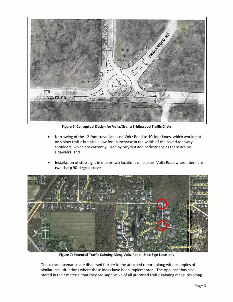
Staff also conducted a meeting with the Village traffic consultant and the Applicant to discuss existing traffic issues along Voltz Road that have been mentioned by residents during the public hearing process of the application. Staff discussed several ways to slow down traffic along Voltz Road with the Village traffic consultant, and three ideas are summarized in the attached Village traffic consultant’s memo:
Installation of a traffic circle at the Voltz/Grant/Bridlewood intersection;
Figure 5: Potential Traffic Calming Along Voltz Road – Possible Traffic Circle Location
Page 6
Figure 6: Conceptual Design for Voltz/Grant/Bridlewood Traffic Circle
Narrowing of the 12-foot travel lanes on Voltz Road to 10-foot lanes, which would not only slow traffic but also allow for an increase in the width of the paved roadway shoulders, which are currently used by bicyclist and pedestrians as there are no sidewalks; and
Installation of stop signs in one or two locations on eastern Voltz Road where there are two sharp 90-degree curves.
Figure 7: Potential Traffic Calming Along Voltz Road - Stop Sign Locations
These three scenarios are discussed further in the attached report, along with examples of similar local situations where these ideas have been implemented. The Applicant has also stated in their material that they are supportive of all proposed traffic calming measures along

Page 7
Voltz Road. Village staff has also reviewed the Village traffic consultant’s report. The interim Village Engineer found the suggestion to narrow the Voltz Road lane widths to be an effective measure which would be easy to implement and benefit all users. The Fire Department also believes that the traffic circle would function successfully for maneuvering their large equipment when the design is refined and detailed.
Tree Preservation & Waiver of Tree Impact Fees
Planning & Zoning Committee Comments: Committee members indicated that they were not interested in waiving any of the tree impact fees as requested by the Applicant.
Applicant Response: The Applicant continues to request that the Village waive $56,000 in tree impact fees to defray the cost of the additional landscaping that the Applicant is installing throughout the development. This is explained further in the material submitted by the Applicant.
Staff Commentary: The attached staff report for the October 20 Planning and Zoning Committee meeting includes the information about the tree replacement fees and removal fees for the development as calculated by the Village Forester when the application last underwent staff review. The site plan has changed since that time, so the preservation of trees may have fluctuated, which could cause the amount of the fees to change when the most recent plan undergoes a more thorough staff review in the future. As a reminder the Village Forester already agreed to waive the removal fees for heritage and landmark trees in poor condition, resulting in a waiver of $73,500 in fees.
Sidewalks Along the Perimeter of the Development
Planning & Zoning Committee Comments: There was discussion from the Committee that the extension of the sidewalk along the Voltz Road frontage was appropriate; however, one Trustee noted that consideration should still be made for installation of a sidewalk along the Waukegan Road frontage of the Subject Property.
Applicant Response: The current plan still proposes a sidewalk along the north side of Voltz
Road along the property frontage; however, the Applicant is still not proposing any sidewalks along Waukegan Road.
Staff Commentary: It should be noted that there is no sidewalk along the east side of Waukegan Road from just south of Walters Avenue all the way south to the other side of railroad overpass. The area without sidewalks is highlighted in yellow on the aerial image below, with the Subject Property outlined in red.

Page 8
Figure 8: Existing Sidewalk Gap Along East Side of Waukegan Road - Noted in Yellow
Stormwater Detention
Planning & Zoning Committee Comments: One trustee asked for a further explanation regarding how detention is being addressed in the revised design
Applicant Response: The Applicant has not provided any additional information regarding how the stormwater functions within the Subject Property. The Applicant will want to address this issue at the Committee meeting. The narrative provided by the Applicant does state that a portion of the stormwater drainage along the northern property line has been modified to ensure that the drainage remains on the property, limiting any impact on the residents to the north of the development.
Staff Commentary: As noted above, the plan still includes the installation and maintenance of a portion of the development’s stormwater on a portion of a Village-owned parcel southeast of the Subject Property. To accommodate this stormwater design, the Applicant continues to request a permanent, non-exclusive easement to be granted to them over the Village-owned parcel. The Applicant requests that this easement be granted in consideration of the dedication of land for the designated right turn lane on westbound Voltz Road. The Village owned parcel is outlined in red below.
Figure 9: Requested Easement for Stormwater Basin on Village Owned Parcel

Page 9
SUMMARY As the Board considers the revised plan, staff suggests the Board focus on the following policy questions:
1. Is the proposed 34-unit single-family detached home planned development on the Subject Property consistent with the property’s R-4 Single Family Residential District zoning?
2. Is the revised development site layout appropriate? a. Are the placement of homes along the north and south property lines appropriate? b. Is the proposed internal roadway configuration appropriate?
i. Is it appropriate that a majority of the road is proposed as a public street, with a small portion being a private street with a restricted access gate for residents and emergency personnel only?
ii. Given the provision of the limited access point to the north to Lee Road, is it appropriate to grant a variation to allow the cul-de-sac length to exceed 1,200 feet?
c. Does the proposed planned development site layout provide a significant public benefit through the preservation of landmark and heritage trees and the provision of community open space and amenities?
3. Are the following off-site improvements appropriate? a. Is the Village Board willing to allow the expansion of the eastern detention basin on the
Subject Property into the adjacent Village-owned parcel by means of a permanent easement?
b. Is it appropriate to accept from the Applicant the dedication of land to accommodate a right-turn lane on east bound Voltz Road (to be installed at Village expense) in exchange for the Village granting an easement on the adjacent Village-owned parcel?
c. Is the proposed sidewalk along the Voltz Road frontage of the Subject Property sufficient for the perimeter of the site?
d. Is it appropriate to consider traffic calming methods along Voltz Road? i. Is installation of a traffic circle at Voltz/Grant/Bridlewood appropriate?
ii. Is it appropriate to narrow the Voltz Road lane widths from 12’ to 10’? iii. Is it appropriate to install one or two stop signs at the eastern 90-degree curves
on Voltz Road?
4. Is it appropriate to grant a waiver of $56,000 in heritage and landmark tree fees? There has been a large public turnout during the public hearings, as well as at the October 20 Planning & Zoning Committee meeting, and we expect members of the public to ask to continue to make statements during the Planning & Zoning Committee review of this request. The Applicant and staff will be present at the December 8 Committee meeting to summarize the proposed revised application and to answer any questions.

Project Traffic Review #3
To: Michaela Kohlstedt, David Schoon, Tom Poupard,Kelly Hamill, & Joe WywrotVillage of Northbrook
From: Bill Grieve
Date: November 20, 2015
Subject: Anets Woods1230 Voltz Road
GEWALT HAMILTON ASSOCIATES, INC. (GHA) has considered various traffic planning alternatives for promoting moreefficient and potentially safer operations in the Anets Woods influence area. These possibilities are discussed below.
Voltz Road
Development AccessAnets Woods proposes its access location on Voltz Road opposite Voltz Court. This a logical location from an accessmanagement perspective, as there would not be another vehicle conflict point introduced on Voltz Road. However,this location is only about 250 feet east of Waukegan Road, which has raised the question if the Anets Woods accessshould be moved further east. Considerations include:
1. The traffic studies prepared by Sam Schwartz Engineering (SSE) analyzed westbound queues on VoltzRoad from Waukegan Road and concluded that traffic would rarely, if ever, back up past the Anets Woodsaccess. They prepared a Synchro traffic model, which supported their findings. In addition, the SSE analysesprobably overestimated the traffic to be generated by Anets Woods, because higher single family home tripequations were used, versus lower empty nester / senior housing. Thus, there will probably be fewer vehiclesentering and exiting Anets Woods from Voltz Road.
2. Moving the Anets Woods access further east poses design challenges. Voltz Road bends about 440 east ofWaukegan Road. And the roadway “climbs” toward the railroad overpass, making vehicle sight distance apotential problem.
Summary Position. Based on the above considerations, we believe that the appropriate location for theAnets Woods access is opposite Voltz Court, where it is currently planned. However, should it be decided toconnect Lee Road through the property to Voltz Road (as discussed in the next section), the traffic analysesshould be updated to determine if an alternate access location should be reevaluated.
Traffic Calming MeasuresThere are currently no locations where Voltz Road traffic has to slow down or stop between Waukegan Road on thewest and Sunset Ridge Road on the east, a distance of about 1 1/3 miles. Village studies have shown that somevehicles travels at speeds higher than the posted speed limit of 30-mph. Slowing down traffic would also benefitpedestrians who walk / bike on Voltz, as there are no sidewalks. Considerations for slowing / calming traffic include:

Anets Woods
1230 Voltz Road
GEWALT HAMILTON ASSOCIATES, INC. - Page | 2
1. To reduce traveling speeds, a roundabout could be constructed at the Voltz Road / Grant Road / BridlewoodRoad intersection. Per the attached exhibit, all entering traffic would yield to any vehicle already traveling inthe roundabout. The design accommodates a Village fire truck and a full sized school bus. The 12-footmountable truck apron will help accommodate occasional larger trucks, such as a moving van.
2. Voltz Road has two 12-foot travel lanes striped and 2-foot (approximate) shoulders. A “traffic calming” toolwould be to restripe Voltz Road for two 10-foot travel lanes. Research has shown that narrower lanes tend toreduce travel speeds. The two feet “saved” in each lane would create 4-foot shoulders, which although notappropriate for sidewalks or bike paths, at least provide more shelter for pedestrians who happen to bewalking or riding a bicycle on Voltz. The following are examples of where narrower lanes have been stripedto help slow down traffic.
Example #1. Golf Road is an east-west collector in Libertyville that is about 36 feet and has an Average
Daily Traffic (ADT) volume of about 5,100 vehicles per day (vpd). Golf was originally striped for two travel
lanes. After many resident complaints and Village traffic studies, parking lanes were striped on both sides of
Golf. Village “after” studies found lower travel speeds. The posted speed limit is 25 mph.
Example #2. When the Village of Northbrook reconstructed Cherry Lane, an east-west collector street, the
pavement section was narrowed and parking lanes and intersection bump-outs added as traffic calming
measures. The ADT on Cherry west of Cedar Lane is 4,800 vpd. The posted speed limit is 25 mph.
Example #3. The Village of Skokie restriped Main Street this year. Travel lanes were narrowed from 12 feet
to 10 feet, so that bike lanes and parking lanes could be striped. The ADT on Main Street is 9,500 vpd. The
posted speed limit on Main Street was reduced from 30 mph to 25 mph in anticipation of the restriping.
Example #4. After reconstructing Dundee Road, the Village of Glencoe took over jurisdiction from the Illinois
Department of Transportation (IDOT). The section of Dundee Road from Green Bay Road to Greenwood
Avenue was reconstructed to provide two 10-foot travel lanes with a 25 mph posted speed limit. The ADT on
Dundee Road just is 14,600 vpd.
3. There are two sharp 90-degree curves toward the east end of Voltz Road that tend to slow traffic down for afew seconds. However, observations indicate that some vehicles travel faster than the posted 10-mph postedspeed limit on the curve sign and some vehicles also travel across the center line of the pavement.
a) The western curve does not have other driveways or streets intersecting with it. A similar location isin Wilmette, where Happ Road bends sharply to the east due in part to high tension wires, where itthen becomes Illinois Road. Although there are no other intersecting streets or drives, Stop signshave been placed on the southbound and westbound approaches. Observations indicate that thistraffic calming strategy works well, particularly as a safety enhancement to keep vehicles fromentering the opposite direction travel lanes while negotiating the tight turn.

Anets Woods
1230 Voltz Road
GEWALT HAMILTON ASSOCIATES, INC. - Page | 3
b) The other 90-degree eastern curve is about 790 feet to the south and has slightly offset intersectionswith Driftwood Lane and South Lane. This location would probably not meet traffic volume warrantsfor an All-way Stop, as published in the manual on Uniform Traffic Control Devices (MUTCD).However, as with the western curve, All-way Stop control could be considered as a safetyenhancement.
Lee Road
In 2007, GHA conducted a study of the Lee Road corridor for the Village that included traffic counts from DundeeRoad on the north, Shermer Road, Grant Road, Walters Road, Waukegan Road, and Voltz Road. That study, whichcontemplated a residential development on the Anets Woods site, was done as part of the Village’s ComprehensivePlan research and concluded that there may be a benefit in connecting the south end of Lee Road to Voltz Road. TheAnets Woods development proposal suggests that the Lee Road issue be revisited. There are two options toconsider:
Option #1 - Extending Lee Road1. There is about 8900 feet of distance between Skokie Boulevard on the east and Waukegan Road on the
west. From a street hierarchy standpoint, Lee Road tends to function as a neighborhood “collector” route.This would suggest that it be extended through the Anets Woods parcel and connect to Voltz Road.
2. If Lee Road is extended, the current Anets Woods site plan does not function well as a collector street, asthere are many driveways directly on the street frontage and there is a forced turn at an internal intersection.In this case, the site plan would be best modified to have a series of cul-de-sacs that intersect thecontinuation of Lee Road to minimize the number of direct access driveways along it.
3. The traffic volume on Lee Road would increase, as drivers would have a direct alternate route to avoid dailypeak period congestion at the Waukegan Road / Dundee Road intersection.
4. The Lee Road / Walters Avenue intersection should be realigned to make Lee Road the “through” route,rather than the current configuration where Lee Road bends slightly, but sharply, into Walters Avenue. All-way Stop control should be considered.
5. If Lee Road is extended, there may be more pressure to improve the Voltz Road westbound approach atWaukegan Road, as more traffic would be drawn to it. As noted, Lee Road would become an alternate routefor motorists to avoid congestion at the Waukegan / Dundee Road intersection. Traffic destined to the southwould turn right onto Voltz Road, then left at Waukegan Road. The increased volume on the westboundapproach could trigger the need for adding a separate left turn lane.
Option #2 - Not Extending Lee Road
1. There are ways to navigate the area south of Dundee Road between Skokie Boulevard and WaukeganRoad. Drivers destined to the south and east can use Grant Road, which links Lee Road with Voltz Road.Drivers destined to the west can use Walters Avenue, which has traffic signal control at Waukegan Road.

Anets Woods
1230 Voltz Road
GEWALT HAMILTON ASSOCIATES, INC. - Page | 4
2. If Lee Road isn’t extended, the Anets Woods site plan effectively serves the proposed development. Theplanned emergency gate at the north end should be coordinated with the Northbrook Fire Department.
3. Appropriate signage at Voltz Road should inform motorists that there is not a through route. Having adifferent street name than Lee Road at Voltz Road would also be beneficial.
4. All-way Stop control should be considered at the Lee Road / Grant Road intersection to help with trafficcontrol for the route to/from Voltz Road.
5. As with the 90-degree turns on Voltz Road, All-way Stop control should be considered at the Lee Road /Walters Avenue intersection as a traffic calming measure to promote operational safety.
Summary Position. Based on the above considerations, it is our opinion that Lee Road should not becontinued through the Anets Woods development to provide a direct connection to Voltz Road. The routeselection flexibility provided by Walters Avenue and Grant Road provides adequate neighborhood accesswithout attracting non-locally generated traffic.
* * * * * * * * * * * * *
This project traffic review conducted by:
William C. Grieve, P.E., PTOESenior Transportation [email protected]


DEVELOPMENT AND PLANNING SERVICES DEPARTMENT
Page 1
MEMORANDUMVILLAGE OF NORTHBROOK
TO: RICHARD A. NAHRSTADT, VILLAGE MANAGER
FROM: MICHAELA KOHLSTEDT, SENIOR PLANNER
DATE: DECEMBER 15, 2015
SUBJECT: PCD-15-04 –1230 VOLTZ ROAD – PLANNED DEVELOPMENT
INTRODUCTIONOn December 15, 2015, the Planning & Zoning Committee will continue to review the revised plans forthe Anets Woods planned development, a 34-unit detached single family residential development. Thisis an application submitted by Edward R. James Partners, LLC, (the “Applicant”) as contract purchaser ofthe property at 1220 and 1230 Voltz Road (the “Subject Property”) which is owned in trust by AnetsFamily, LLC (the “Owner”). On December 8, 2015 the Planning & Zoning Committee met to discuss theapplication; however, due to the timing constraints of the meeting and the number of residents thatappeared to provide public testimony, there was insufficient time for the Committee members andother Board members present to discuss the revised plan.
DECEMBER 8 PLANNING & ZONING COMMITTEE MEETING SUMMARY & APPLICANT’S RESPONSEDuring the December 8 Planning & Zoning Committee meeting the Applicant presented an amendedplan (attached is a copy of the Applicant’s amended submittal as well as a copy of the staff report for theDecember 8 meeting). Following the presentation by the Applicant, staff and the Village trafficconsultant made a brief presentation summarizing the traffic memo provided by the Village trafficconsultant (attached again for reference), and then the Committee heard testimony from members ofthe public.
A majority of the concerns raised by members of the public were:
The development is too dense.
There should only be access for emergency vehicles north to Lee Road from the SubjectProperty.
The restricted access will result in drivers heading south on Lee Road turning around in thedriveways at the end of Lee Road when they are unable to gain access through the restrictedgate.
The development is going to increase the existing traffic problems along Voltz Road.
The development entrance should be placed on Waukegan Road.
There was no time remaining following the public comment for members of the Committee to providecommentary on the revised plan. The meeting was continued to Tuesday December 15, 2015.
Additional correspondence from members of the public received by the Village following the December8 meeting is attached for review.
MATERIALS SUBMITTED BY THE APPLICANTThe Applicant has provided the attached response following the December 8 meeting addressingWaukegan Road access, Lee Road access, tree impact fees, and Voltz Road traffic calming.

Page 2
Regarding Lee Road access, the Applicant has revised the proposed restricted access north to Lee Roadby moving the gate south into the development and creating an area on the Subject Property to allowdrivers to turn around on the Subject Property if they mistakenly end up at the development, whichwould be a restricted access for residents and emergency personnel only. The Applicant also proposesinstalling a sign that states Lee Road is not a through street somewhere north of Walters Avenue on LeeRoad to assist in preventing additional traffic heading south on Lee to the restricted access drive.
Regarding Waukegan Road access, the Applicant has submitted a memo from their engineers as well asfrom their traffic consultant discussing IDOT requirements, significant grade changes on the SubjectProperty along Waukegan Road, and the location of the heritage and landmark trees, all of which theybelieve makes access from Waukegan Road “neither practical, feasible, nor desirable from a publicsafety standpoint.”
SUMMARYStaff, along with the Village traffic consultant, and the Applicant will be present at the December 15meeting to answer any questions the committee may have pertaining to the proposed project, includingthe material attached to this report.
The summary at the end of the attached December 8 staff memo outlines the issues for the Committeeto consider as it prepares its recommendation regarding this application.