Urbanization through Industrialization-a developmental ... Harbour Municipality was added to this...
17
Volume-III, Issue-VI May 2017 382 International Journal of Humanities & Social Science Studies (IJHSSS) A Peer-Reviewed Bi-monthly Bi-lingual Research Journal ISSN: 2349-6959 (Online), ISSN: 2349-6711 (Print) ISJN: A4372-3142 (Online) ISJN: A4372-3143 (Print) UGC Approved Journal (SL NO. 2800) Volume-III, Issue-VI, May 2017, Page No. 382-398 Published by Scholar Publications, Karimganj, Assam, India, 788711 Website: http://www.ijhsss.com Urbanization through Industrialization-A Developmental Approach: A Case Study of South 24 Parganas District, West Bengal Sanat Kumar Purkait Assistant Professor, Department of Geography, Raidighi College West Bengal, India Soumyajit Halder Research Scholar, Department of Geography, University of Calcutta, West Bengal, India Abstract The article trying to explore the future of Urbanization in South 24 Parganas district and the links between Urbanization and Industrialization and their corresponding development policies. It offers an overview regarding the historical process and changes which occurred in the state and approach of planning, discussing the process responsible for the urbanization through industrialization. It also trying to investigate the period of Industrial liberalization (1990-91) and its effect on the industrial setup in this district. It explores situation regarding the stagnating urban development, industrialization and planning as well as the perspectives regarding the integrated planning approach in a wider national context. The article concludes that even if today industrialization is no longer equivalent with urbanization, the (national) industrialization strategies must include the debate regarding integrated urban development. Key words: Industrialization, urbanization, Liberalization, South 24 Parganas. Introduction: Urbanization is a process whereby increasing proportions of the population of a region or a country live in urban areas. Urbanization has become a major demographic issue in the 21st Century not only in India but also all over the world. The level of urbanization in terms of the proportion of urban population to the total is low in India but the urban population in absolute terms is high. Urbanization in India began to accelerate after independence, due to the country's adoption of a mixed economy, which gave rise to the development of the private sector. Urbanisation is taking place at a faster rate in India. Mumbai saw large scale rural-urban migration in the 21st century. Mumbai accommodates 12.5 million people, and is the largest metropolis by population in India, followed by Delhi with 11 million inhabitants. Witnessing the fastest rate of urbanization in the world, as per 2011 census, Delhi's population rose by 4.1%, Mumbai's by 3.1% and Kolkata's by 2% as per 2011 census compared to 2001 census. Estimated population, at the current rate of growth, by year 2015; Delhi stands at 26 million; Mumbai at 24
Transcript of Urbanization through Industrialization-a developmental ... Harbour Municipality was added to this...

Volume-III, Issue-VI May 2017 382
International Journal of Humanities & Social Science Studies (IJHSSS) A Peer-Reviewed Bi-monthly Bi-lingual Research Journal ISSN: 2349-6959 (Online), ISSN: 2349-6711 (Print) ISJN: A4372-3142 (Online) ISJN: A4372-3143 (Print) UGC Approved Journal (SL NO. 2800) Volume-III, Issue-VI, May 2017, Page No. 382-398
Published by Scholar Publications, Karimganj, Assam, India, 788711 Website: http://www.ijhsss.com
Urbanization through Industrialization-A Developmental Approach:
A Case Study of South 24 Parganas District, West Bengal Sanat Kumar Purkait
Assistant Professor, Department of Geography, Raidighi College West Bengal, India
Soumyajit Halder
Research Scholar, Department of Geography, University of Calcutta, West Bengal, India
Abstract
The article trying to explore the future of Urbanization in South 24 Parganas district and
the links between Urbanization and Industrialization and their corresponding development
policies. It offers an overview regarding the historical process and changes which occurred
in the state and approach of planning, discussing the process responsible for the
urbanization through industrialization. It also trying to investigate the period of Industrial
liberalization (1990-91) and its effect on the industrial setup in this district. It explores
situation regarding the stagnating urban development, industrialization and planning as
well as the perspectives regarding the integrated planning approach in a wider national
context. The article concludes that even if today industrialization is no longer equivalent
with urbanization, the (national) industrialization strategies must include the debate
regarding integrated urban development.
Key words: Industrialization, urbanization, Liberalization, South 24 Parganas.
Introduction: Urbanization is a process whereby increasing proportions of the population of a
region or a country live in urban areas. Urbanization has become a major demographic issue in the
21st Century not only in India but also all over the world. The level of urbanization in terms of the
proportion of urban population to the total is low in India but the urban population in absolute terms
is high. Urbanization in India began to accelerate after independence, due to the country's adoption
of a mixed economy, which gave rise to the development of the private sector. Urbanisation is
taking place at a faster rate in India.
Mumbai saw large scale rural-urban migration in the 21st century. Mumbai
accommodates 12.5 million people, and is the largest metropolis by population in India,
followed by Delhi with 11 million inhabitants. Witnessing the fastest rate of urbanization in
the world, as per 2011 census, Delhi's population rose by 4.1%, Mumbai's by 3.1%
and Kolkata's by 2% as per 2011 census compared to 2001 census. Estimated population, at
the current rate of growth, by year 2015; Delhi stands at 26 million; Mumbai at 24

Urbanization through Industrialization-A Developmental Approach:… Sanat Kumar Purkait & Soumyajit Halder
Volume-III, Issue-VI May 2017 383
million, Kolkata at 16 million, Bangalore at 11 million, Chennai, and Hyderabad at 10
million.
Causes of Urbanization:
The main causes of urbanization in India are:
Expansion in government services, as a result of the Second World War
Migration of people during the partition of India
The Industrial Revolution
Eleventh five-year plan that aimed at urbanization for the economic development
of India
Economic opportunities are just one reason people move into cities
Infrastructure facilities in the urban areas
Growth of private sector after 1990.
The Study Area: South 24 Parganas is the
southernmost district of the state occupying
southern part of the Bengal Delta. The district lies
between 21°29'0" north and 22°33'45"north
latitudes and 88°3'45" east and 89°4'50" east
longitudes. South 24 Parganas was part of the
undivided 24 Parganas. On 1 March 1986, 24
Parganas was divided into two separate parts
mainly for administrative convenience. The
northern part became known as North 24
Parganas and the southern part as South 24
Parganas. The district presently has thirty two
Police Stations and twenty nine Community
Development Blocks (C. D. Block). Total area
covered by the district is 9,960 sq.km. It was the
second most populous district of West Bengal
with a total population of 81, 61,961 in
2011.Urban population jumped from 95,627 in
1951 to 20, and 87,773 in 2011, registering a
staggering growth rate of 2083.25 per cent, which
is ten times greater than rural growth rate.
Objective: The basic objective of this paper is to
identify-The trend of urbanization in South 24 Parganas with special focus on pattern of
urban expansion, urban growth rate, components of urban growth, rate of industrial
development and relation between urbanization and industrialization. These have been
discussed elaborately in the following part.
Methodology: The present analysis has been carried out in three parts. Firstly, extensive
survey of literature on varied aspects of urbanization and industrial development was made.
Figure 1.1: Location Map of Study Area

Urbanization through Industrialization-A Developmental Approach:… Sanat Kumar Purkait & Soumyajit Halder
Volume-III, Issue-VI May 2017 384
These include theoretical premises and case studies from West Bengal and India. Relevant
reports, like the Report of the National Commission for Urbanisation (1988); District
Human Development Report of South 24 Parganas (2009); Human Development Report of
West Bengal (2004) etc.were collected from the concerned government authorities.
Secondary data were collected from various sources, like the Census of India; the Bureau of
Applied Economics and Statistics; the Kolkata Municipal Development Authority; the
District Industrial Centre, South 24 Parganas etc. Administrative and thematic maps of
various dimensions were gathered from different sources, like the Census of India and the
National Atlas and Thematic Mapping Organization etc.. Secondly, detailed discussions
were made with various academic, nonacademic and administrative persons, and more
significantly with local residents on different urban-economic issues pertaining to the study
area. Thirdly, compilation and computation of collected data were made. Relevant statistical
techniques were applied. Relevant maps and diagrams were prepared with application of the
Geographical Information System and other relevant software.
Urbanization in South 24 Parganas: The phenomenon of urbanization occurs in South 24
Parganas district in the form of aerial expansion of various new townships (Baruipur,
Sonarpur, Budge Budge, Canning, and Diamond Harbour etc.) in South 24 Parganas. Land
use and Land cover scenario in South 24 Parganas has undergone a radical change since the
introduction of New Economic Policy in early 1990’s and these changes involve a series of
complex interaction between biophysical and socio-economic variables. (Roy and Giriraj,
2008)
Apart from land use/cover change, significant development of the district has taken
place resulting in increased demand for various built-up land e.g., residential,
commercial, industrial purposes etc. There has been a significant change in the
occupational structure of its residents which has also bearing on district’s landscape.
The detailed urbanization process in South 24 Parganas district during the period of
110 years (1901-22011) is explained below:
TABLE
Growth of Population by sex on different Census years in the district of South
24-Parganas
(Population in number)
Year Urban Population
1901 312172
1911 428136
1921 484404
1931 570005
1941 813467
1951 1216152
1961 1997957
1971 2970320

Urbanization through Industrialization-A Developmental Approach:… Sanat Kumar Purkait & Soumyajit Halder
Volume-III, Issue-VI May 2017 385
Figure 1:2
Urban Areas of Different Categories: There has been only one type of statutory town in
South 24 Parganas, i.e. municipality. The oldest municipalities are Jaynagar-Mazilpur and
Baruipur. Both of them were established in 1869. Rajpur (later expanded and renamed as
Rajpur-Sonarpur Municipality) was formed in 1876. Budge Budge Municipality was
created in 1900. Diamond Harbour Municipality was added to this list in 1982. Later two
new municipalities, namely Maheshtala and Pujali, were created in 1993. No further
addition was made in the following decade. Growth of census towns has been really
spectacular in South 24 Parganas. Number of these settlements increased almost
continuously, except during 1990s, i.e. from only 3 in 1951 to 111 in 2011. Outgrowths
have remained less numerous here. South 24 Parganas contains southern part of the Kolkata
Urban Agglomeration, which was truly an urban continuum of the Kolkata Mega City. It
has seven urban units, like Maheshtala, Budge Budge, Pujali and Rajpur-Sonarpur
municipalities, Joka outgrowth and ChataKalikapur, Balarampur, Uttar Raypur census
towns.(Bagch & Chatterjee, 2015)
1981 1348116
1991 760377
2001 1086220
2011 2087773 Note : Base 1901=100 for undivided 24
Parganas from 1901 to 1971 & Base
1981=100 only for South 24-Parganas from
1981onwards
Source : Census of India

Urbanization through Industrialization-A Developmental Approach:… Sanat Kumar Purkait & Soumyajit Halder
Volume-III, Issue-VI May 2017 386
Level of Urbanisation: Level of urbanization has been very low in South 24 Parganas.
Upto 1971 less than 10 per cent of total population of this district was urban dwellers. The
level increased during the following decades and in 2011 one-fourth of total population was
contained in urban areas. Proportion of urban population in this district always remained
much below the state average, though the difference has been narrowing down gradually.
As per the latest census of 2011, South 24 Parganas was the ninth ranking district of the
state in terms of urban proportion of total population. Moreover, among the districts
surrounding the Kolkata Metropolis, the lowest level of urbanization has always been
observed here. Sub-district level analysis shows that Region I have become semi-urban and
it has been followed by gradually urbanizing Region II and largely rural Region III
respectively. The analysis has been done by dividing the period since 1951 into two phases.
The first phase ranges from 1951 to 1981 and the second phase covers from 1991 to2011.
Figure: 1.3

Urbanization through Industrialization-A Developmental Approach:… Sanat Kumar Purkait & Soumyajit Halder
Volume-III, Issue-VI May 2017 387
In 1st Phase, Bishnupur became urbanized only during 1960s which is very low level of
urbanization of 4.25 per cent in 1981. Only two Police Stations in Region II, like Baruipur
and Diamond Harbour and another two Police Stations in Region III, like Canning and
Jaynagar had some urban population between 1951 and 1981. Proportions of urban
population of these Police Stations varied around 10 per cent during this period. In 1981, for
instance, level of urbanization was 11.39 per cent in Baruipur, 11.27 per cent in Canning,
8.86 per cent in Diamond Harbour and
only 6.42 per cent in Jaynagar.
During the 2nd
Phase, level of
urbanization rose remarkably in Region
I with more than three-fifth of total
population living in urban areas in 2011.
Appreciable increase in urban share of
total population also took place in
Region II with 17.67 per cent urban
population in 2011. Urbanisation
remained at a very low level in Region
III having only 7.54 per cent of its
population as urban dwellers. Most of
the previously nonurban C. D. Blocks,
like Diamond Harbour II, Falta, Kulpi,
Mandirbazar and Magrahat I in Region
II and Canning II, Basanti and
Mathurapur I in Region III, got
urbanized, though at varying levels.
Thus in 2011, all C. D. Blocks in
Region I, nine out of ten in Region II
and six out of thirteen in Region III became shareholders of total urban population of the
district. In 2011, Budge Budge I had the highest level of urbanization (86.96 per cent),
being closely followed by Thakurpukur-Maheshtala (85.56 per cent) and Sonarpur (72.73
per cent). The lowest level of urbanization was found in Basanti (1.97 per cent), proceeded
by Diamond Harbour II (2.62 per cent) and Canning II (4.43 per cent) successively (Figure
4). Undoubtedly there has been a greater impact of industrialization & kolkata municipal
area fallen in the north western cluster of south 24 Parganas which results greater rate of
urbanization.
Pattern of Urbanisation: A close look over the locations of urban centres in South 24
Parganas shows that, for a long time, at least upto 1981, urban development in this district
took place largely under the urban influence of Kolkata and its non agricultural activities.
Diffusion started only during 1980s, when new census towns emerged in two other regions
also. In South 24 Parganas five broad patterns in distribution of urban centres can be
identified in 2011, as have been mentioned below. i) Municipalities and adjoining census
Figure: 1.4

Urbanization through Industrialization-A Developmental Approach:… Sanat Kumar Purkait & Soumyajit Halder
Volume-III, Issue-VI May 2017 388
towns; as found around Budge Budge (M), Maheshtala (M), Rajpur-Sonarpur (M) and
Baruipur (M). ii) Agglomeration of census towns near municipalities and larger census
towns, as happened in case of the urban agglomeration in Budge Budge II. iii) Clustered
census towns either surrounding rail-road junctions, as found in Sonarpur, Baruipur,
Magrahat II, Jaynagar I and II or surrounding road crossings as observed in Falta, Magrahat
I, Bishnupur I and II. iv) Group of census towns located in linear fashion along major
transport routes, as noticed in Magrahat II, Mathurapur I, Mandirbazar and Canning I. v)
Scattered urban settlements, as developed in Basanti and Kulpi. Presently four major
regions of urbanisation, found in this district, include: i) Budge Budge-Maheshtala-
Bishnupur Region having three municipalities and thirty six census towns, ii) Sonarpur-
Baruipur-Canning-Bhangar Region having two municipalities and thirty one census towns,
iii) Mandibazar-Mathurapur- Jaynagar Region having one municipality and fifteen census
towns, iv) Magrahat-Diamond Harbour-Falta Region having one municipality and twenty
six census towns.
From the above table, it is clear that till 1951 urbanization mainly limited to Budge
Budge and some part of Maheshtala & Sonarpur. In the decade of 1960-80, the urbanization
takes place in the adjacent block of Kolkata (mainly in Metiabruz, Maheshtala & Budge
Budge) with the effect of industrialization and service sectors. After the era of liberalization
sound industrial development trigger the rate of urbanization. As a result various urban
pockets like Budge Budge, Baruipur, Sonarpur, and Thakurpukur- Maheshtala were
developed.
Degree of Urbanisation: Discussion at C. D. Block level between 1991 and 2011 produces
more interesting results. In 1991 degree of urbanization was very high in Maheshtala, and

Urbanization through Industrialization-A Developmental Approach:… Sanat Kumar Purkait & Soumyajit Halder
Volume-III, Issue-VI May 2017 389
high in Thakurpukur-Metiabruz and Budge Budge I. Canning I was at very low level. Rest
of the urbanised blocks had low degree of urbanisation. Situation changed remarkably
during the following period. Budge Budge I attained very high and exceptionally high
degrees of urbanization in 2001 and 2011 respectively. In fact, both number of urban
centres/ 100 sq. km. and share of urban area in total were the highest in Budge Budge I
among all C. D. Blocks. Another major transition was observed in case of Sonarpur. It
moved from low to moderate and then to high level between 1991 and 2011. Thakurpukur-
Maheshtala also moved towards a very high degree of urbanization in 2011. Another
noticeable feature is gradual upward movement of some C. D. Blocks, namely Bishnupur II,
Baruipur, Bhangar I, Diamond Harbour I, Magrahat II, Budge Budge II, from very low or
low levels to moderate level during this phase. In 2011 C. D. Blocks having low degree of
urbanization were from Region II and Region III, except Bishnupur I. Kulpi and Basanti
had very low degree of urbanization in 2011.
Figure 1:5: Blockwise Change of Urban Population (1991-2011)
Urbanization through Industrialization-A Developmental Approach:… Sanat Kumar Purkait & Soumyajit Halder
Volume-III, Issue-VI May 2017 390
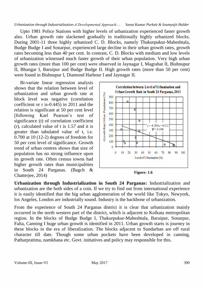
Upto 1981 Police Stations with higher levels of urbanization experienced faster growth
also. Urban growth rate slackened gradually in traditionally highly urbanized blocks.
During 2001-11 three highly urbanized C. D. Blocks, namely Thakurpukur-Maheshtala,
Budge Budge I and Sonarpur, experienced large decline in their urban growth rates, growth
rates becoming less than 40 per cent. In contrast, C. D. Blocks with medium and low levels
of urbanization witnessed much faster growth of their urban population. Very high urban
growth rates (more than 100 per cent) were observed in Jaynagar I, Magrahat II, Bishnupur
II, Bhangar I, Baruipur and Budge Budge II. High growth rates (more than 50 per cent)
were found in Bishnupur I, Diamond Harbour I and Jaynagar II.
Bi-variate linear regression analysis
shows that the relation between level of
urbanization and urban growth rate at
block level was negative (correlation
coefficient or r is-0.445) in 2011 and the
relation is significant at 50 per cent level
[following Karl Pearson’s test of
significance (t) of correlation coefficient
(r), calculated value of t is 1.57 and it is
greater than tabulated value of t, i.e.
0.700 at 10 (12-2) degrees of freedom for
50 per cent level of significance. Growth
trend of urban centres shows that size of
population has no strong influence upon
its growth rate. Often census towns had
higher growth rates than municipalities
in South 24 Parganas. (Bagch &
Chatterjee, 2014)
Urbanization through Industrialization in South 24 Parganas: Industrialization and
urbanization are the both sides of a coin. If we try to find out from international experience
it is easily identified that the big urban agglomeration of the world like Tokyo, Newyork,
los Angeles, London are industrially sound. Industry is the backbone of urbanization.
From the experience of South 24 Parganas district it is clear that urbanization mainly
occurred in the north western part of the district, which is adjacent to Kolkata metropolitan
region. In the blocks of Budge Budge I, Thakurpukur-Maheshtala, Baruipur, Sonarpur,
Falta, Canning I huge urban growth is identified in 2011. Urban growth starts is journey in
these blocks in the era of liberalization. The blocks adjacent to Sundarban are off rural
character till date. Though some urban pockets have been developed in canning,
Patharpratima, namkhana etc. Govt. initiatives and policy may responsible for this.
Figure: 1.6

Urbanization through Industrialization-A Developmental Approach:… Sanat Kumar Purkait & Soumyajit Halder
Volume-III, Issue-VI May 2017 391
We can easily connect the relationship between urban growth and industrial
development. We see that the urban blocks are industrially developed. In falta development
of Falta SEZ, Oil refining factories in budge budge, surgical equipment centre in Baruipur,
Calcutta leather complex in Bantala, canning may trigger the urban development in the
district of South 24 Parganas which is showing in Figure.
Though some big industrial initiatives were shown in this district but mainly this district
was dependent on to MSME's. A large portion of Non-agricultural workers depend on
various small and medium size industries like Food processing, Zari embroidery, silver
filigree, fireworks making etc. From MSME's a huge proportion of revenue was earned. It is
mentioned that West Bengal ranks 1st in MSME development and in this South 24 Parganas
district play a big role.
There is a strong positive relation between level of industrialization and growth of urban
population at block level for the period of 1945-2015. It is clearly shown that rate of
y = 3E-06x + 1.3156 R² = 0.1677
0
10
20
30
0 500000 1000000 1500000 2000000 2500000 3000000 3500000
RA
TE
OF
IN
DU
ST
RIA
LIS
AT
ION
(%)
Urban Population
Fig: 1.8 Relationshipship Between Urban Population & Rate Of
Urbanization(1901-2015)
Figure 1:7: Urbanization through Industrialization in South 24 Parganas

Urbanization through Industrialization-A Developmental Approach:… Sanat Kumar Purkait & Soumyajit Halder
Volume-III, Issue-VI May 2017 392
industrialization strongly influenced the urban growth. With the starting of liberalized
industrial policy urban population may significantly increased. By this a significant part of
Non- agriculture based population triggers the rate of urbanization and a huge migration
occurred in the district to meet the needs of labour force.
Industrial Scenario in South 24 Parganas:
2.1 Existing Status of Industrial Areas in the District of 24 Parganas (South):
Sl.
No.
Name of Ind.
Area
Land
acquired
(In
hectare)
Land
developed
(In hectare)
Prevailing Rate
Per Sqm (In Rs.)
No of
Plots
No of
allotted
Plots
No. of
Units in
Production
1 Behala I.E 15.43 acre 15.43 acre Rs.2/- per Sq.ft.
per month
101 101 99
2 Baruipur I.E 4.70 acre 4.70 acre Rs.30,000/- per
Sq.ft. covered
area & 64,000/-
uncovered
2 2 2
3 Santoshpur
I.E
16.889
acre
16.889 acre Rs.1 lakh per
katha
113 113 113
4 Falta Ph-I 172 acre 109are - - - 20
5 Falta Ph-II 200 acre 41 acre - - - -
6 Falta SEZ 280 acre 280 acre - - - -
7 Food Park at
Santoshpur
12 acre 12 acre - - - -
Source: - WBSIDC & WBIIDC
Industries at a Glance
Sr. No. Head Unit Particulars
1. Registered Industrial Unit No. 6876
2. Employment in Large and Medium Industries No. 416545
3. No. Of Industrial Area No. 7
Source: - District Statistical Handbook of BAES & Economic Review, 2011-12, Govt.of W.B
Details of Existing Micro & Small Enterprises and Artisan Units in the District:
Some Major Large Scale Industries / Public Sector undertakings
List of the units in 24 Parganas (South) & nearby Area
Sl. No. Name of the Unit
1 Down Stream Units of HPL ( 10 Units)
2 Gontermann-Pipers India Ltd.
3 Kohinoor Paper & Newsprint

Urbanization through Industrialization-A Developmental Approach:… Sanat Kumar Purkait & Soumyajit Halder
Volume-III, Issue-VI May 2017 393
4 W.B green Energy Dev. Corpn. Ltd.
5 Jute Mills ( 6 units)
6 K.H.leather Industries, Bantala,24 Pg(S)
7 Mr. Nissat Sakeel & Md. Sakeel, Bantala
8 Paymental Tanniries,bantala
9 S.M enterprises, Bantala
10 Seo sankar Das & B.Ram, Bantala
11 Sip Shing Tannery, Bantala
12 Welcome Leather, Bantala
Growth Trend Industrial projects implemented in the district:
Year No. of Units Invt. (In Cr.)
2008 21 63.88
2009 18 251.01
2010 35 180.94
Source: Economic Review, 2011-12, West Bengal
Vendorisation / Ancillarisation of the Industry: Development of ancillary units depends
upon the establishment of new industrial unit’s mainly large scale/medium scale sector. It is
already stated that about 180 large/medium scale units have been set up in the district, in
addition to 63 electronic units in Salt Lake Electronic Complex. Most of the large scale
unit’s viz. jute mills, engineering units, textile mills, etc. came up in the district during
British period and procure huge quantity of their requirement from SSI sector. Hence, the
process of Ancillarisation can be started by setting up units in the following areas:-
1) Corrugated paper boxes for packing 2) Card board boxes for packing of Hosiery products
and leather shoes 3) Bobbin for jute & textile mills 4) Polythene pouch for milk 5) Printing
of Polythene bags 6) Jute & textile machinery parts 7) Electronic parts 8) Tin container for
paints and varnish 9) Parts for engineering items 10) Basic drug 11) Glass bottles 12)
Plastic containers for paints & varnish 13) Railway wagon parts
Service Enterprises:
Potentials areas: Baruipur, Falta, Canning, Sonarpur, Garia, Joka, Budge Budge, Diamond
Harbour etc.
Potential for new MSMEs: MSE units cater
a wide range of industries. These include
plastic and moulded products, mustard oil,
wheat grinding, readymade garments,
machine tools, corrugated paper, ball point
pen refill, hydraulic equipment, electrical
signaling equipment, ceramic tiles, refueling
of industrial gases, detergent powder,
Figure 1.9: Calcutta Leather Complex, Bantala

Urbanization through Industrialization-A Developmental Approach:… Sanat Kumar Purkait & Soumyajit Halder
Volume-III, Issue-VI May 2017 394
fabrication work, chemical equipment & system, ayurvedic medicine and unani medicine,
glass products, plastic granules, electrical light fittings, leather goods, leather shoe upper,
cotton cloth knitted, thinner, computer stationery, ice block, spice, fibre glass, phenyl,
pharmaceutical products, paints liquid soap, lead ingot, coconut shell powder, taramind seed
powder, jute sticks. Apart from these products, there are some items which are 100 percent
exported manufactured by SSI units at Falta Special Economic Zone. These items cover
base paper, tissue paper, cut paper, cutting tools, garage equipments etc.
Calcutta Leather Complex, Bantala: The integrated leather complex widely known as the
Calcutta leather complex is located at the distance of about 14 km from the main business
hub of kolkata. The complex has a capacity of developing 1000 tonnes of hide per day.
Calcutta leather complex is spread over a sprawling 1100 acres (450 hectares). Presently,
200 tanneries have set up shop in this leather complex at Bantala. Another 30 tanneries are
awaiting the requisite certificate from West Bengal.
Special Economic Zone, Falta: Falta
Special Economic Zone was set up by the
Government of India in the year 1984. This
has now come under the purview of the SEZ
Act & Rules with effect from 10th
February,
2006 in terms of Government of India. The
objective have been set up as generation of
additional economic activity, promotion of
goods and services, promotion of investment
from domestic and foreign sources, creation
of employment opportunities, development
of infrastructural facilities etc.
Growth Center: Falta Industrial Growth Center
Total area : 172 acre
Land for allocation of Industrial units: 121 acre
Access through : NH 117
Land allotted: 103 acre
Lease premium: Rs.22.00 lakh / acre
Location: 50km away from Kolkata, beside Falta Economic Zone
Up‐coming project: Falta Phase‐II:
Area under plan: 260 acre
Land already allotted: 200 acre
Access through : NH 117
Lease premium: Rs.5.75 lakh / acre (during 2007)
Existing Clusters of Micro & Small Enterprise:
Figure 2.0: Falta Sez

Urbanization through Industrialization-A Developmental Approach:… Sanat Kumar Purkait & Soumyajit Halder
Volume-III, Issue-VI May 2017 395
Detail of Major Clusters: Zari Embroidery, Silver Filigree, Surgical Instruments are the
major cluster available in South 24 Parganas district.
Manufacturing Sector Zari Embroidery, Silver Filigree, Surgical Instruments
Details for Identified cluster (Under MSME-DI, Kolkata)
(1) Name of the cluster: - Surgical Equipment Cluster, Baruipur, 24 Pgs (S)
2. Name of the cluster: Zari Embroidery, Silver Filigree, 24 PGS. (S)
Subject Cluster
Zari Embroidery Silver Filigree
Principal product Zari Embroidery Silver ornaments & Filigree products
Name of the
Manufacturer
Budge Budge Block-II Zari
Embroidery cluster Industrial
Co-operative Society Ltd.
The Mograhat Silver Filigree cluster
development Industrial Co-operative
Society Ltd.
No. of Functional
Unit
4500 650
Turnover Rs. 38 Crore Rs. 110 Crore
Employment 12000 1650
Thrust areas Supply of raw materials Designing raw materials, energy
efficient & reducing wastage
1 Principal Products Manufactured in the
Cluster
Surgical Instruments
2 Name of the SPV Baruipur Surgical Instrument Manufacturing
Apex Association (BASIMAA)
3 No. of functional units in the clusters 200
4 Turnover of the Clusters Rs.6,17,368
6 Employment in Cluster 42
7 Average investment in plant &
Machinery
232.27 lakh

Urbanization through Industrialization-A Developmental Approach:… Sanat Kumar Purkait & Soumyajit Halder
Volume-III, Issue-VI May 2017 396
Food Processing Industries: Till 2006-07, number of food processing units in the district
was 157. New units registered since 2007 is as given below. A total of 2505 people are
directly involved in the food processing industry for their livelihoods. Out of which 7.66%
is female worker. According to definition of MSME act 2006, the distribution of the units is
as follows:
Units 2007-08 2008-09 2009-10 2010-11 2011-12 Total
Micro 60 43 41 22 82 248
Small - - 12 2 3 17
Total 60 43 53 24 85 265
FPO licensed food unit in the district:
No of units in the district which acquired FPO license under different food category are
given below:
0
50000
100000
150000
200000
2004-05 2005-06 2006-07 2007-08 2008-09 2009-10 2010-11 2011-12 2012-13
NU
MB
ER
OF
UN
IT A
ND
EM
PL
OY
ME
NT
YEAR
FIG 2.1. NUMBER OF SMALL SCALE INDUSTRIES AND ITS EMPLOYMENT
Unit Employment
0
100000
200000
300000
400000
500000
2005 2006 2007 2008 2009 2010 2011 2012 2013
NU
MB
ER
OF
UN
IT &
IT
S
EM
PL
OY
ME
NT
FIG 2.2: NUMBER OF REGISTERED FACTORIES, STATE GOVT. OFFICES & ITS
EMPLOYMENT
Number Employment State Govt. offices

Urbanization through Industrialization-A Developmental Approach:… Sanat Kumar Purkait & Soumyajit Halder
Volume-III, Issue-VI May 2017 397
Group Name No. of Units
Canned/ fruit /Veg, Jam Group, Pickles, Fruit juice, Squash Group,
Chutney, Non-Fruit Synthetic Syrup, Vinegar, Tomato
Sauce/Ketchup, Other sauce Soyabean Sauce, Non-Fruit vinegar
41
Preserve Candy & Crystallized Fruit & Peel 29
Sweetened aerated water (without Fruit Juice/Pulp) 4
Dehydrated fruits& vegetable Bottled fruits 1
Investment opportunities:
1. The district is very close to Kolkata. Hence marketing of products would not be a
problem.
2. A large scale Sunflower oil processing units can be set up in the district.
3. A big guava processing unit with state of the art machineries can be set up to
manufacture Puree, Pulp, Jam and Jelly.
4. Scheme need to be designed to introduce mechanization in processing of
molaso (date). It has high demand in the domestic market.
5. Cold storage for Sea fish preservation
6. Cold storage for sweet water fish preservation
7. Similarly automation is needed in manufacturing of Karanda. Around 15 such
manufacturing units are found in Atghora of South 24 Parganas.
Conclusion: In the district of South 24 Parganas the process of urbanization mainly are off
Kolkata-centric in nature. Over a vast part of the district urban expansion has been carried
out with the impact of industrialization in the era of liberalization. But this district is mainly
depends onto primary sector and a large number no. of people are poor and non-efficient
rural people, urbanization may inversely affected these people which also have to consider.
However, the recent sudden increase in number of census towns and urban population
thereby in South 24 Parganas highlighted the need for paying more attention to this class of
urban settlements. By this study it is clear that urbanization is mainly depend onto
industrialization, so for urban growth more Govt. initiatives have to be carried out for
investment and industrial development. But it has to be remembered that it should be
sustainable industrial development. More industrial training, establishments of ITI can make
efficient industrial labour force which certainly changes the scenario. Though Govt. take
necessary steps to set up Falta SEZ, Bantala leather complex, industrial training centre,
budge budge etc. and make sound development in MSME sector. But the lack of big
investment is evident which only can change South Parganas into a urbanized district.
Reference:
1. Bagch, E, Chatterjee, K. Nature of the Process of Urbanisation in South 24 Parganas
District of West Bengal, India: A Spatio-temporal Analysis Arch. Appl. Sci. Res.,
2015, 7 (5):73-90

Urbanization through Industrialization-A Developmental Approach:… Sanat Kumar Purkait & Soumyajit Halder
Volume-III, Issue-VI May 2017 398
2. B. Bhattacharya. Urban Development in India, Second Revised Edition, Concept
Publishing Company, New Delhi, 2006, pp. 291-293.
3. Best, R. H. and Coppock, J. T., 1962. The Changing Use of Land in Britain, Faber and
Faber, Chapters 6 and 7.
4. Bosiac, G, Dragoi M. A. Relations between Urbanization and Industrialization in
Hunedoara Municipality Journal of Settlements and Spatial Planning, vol. 3, no. 1
(2012) 27-34
5. Bourne, L.S. and J.W. Simmons, 1978. Systems of Cities: Readings on Structure,
Growth and Policies, Oxford University Press, New York.
6. Brief Industrial Profile of South 24 Parganas district by MSME development Institute,
Kolkata
7. Carter, H., 1981. Urban Geography, Arnold-Heinemann, New Delhi, p. 434.
8. Chauhan, D.S., 1965. Studies in Utilization of Agricultural Lands, Educational
Publishers, Agra, pp.3-33.
9. D. A. Rondinelli. ‘Balanced Urbanization, Spatial Integration, and Economic
Development in Asia: Implications for Policy and Planning’,C. S. Yadav (ed.),
Comparative Urbanization: City Change and Growth, Concept Publishing Company,
New Delhi, 1986, p. 164.
10. Directorate of Agriculture Evaluation Wing, Govt. of W.B.(2013)
11. District Census Handbook, South 24 Parganas (2009)
12. District Census Handbook, South 24 Parganas (2013)
13. Herbert, D., and Thomas, C., 1982: Urban Geography: A First Approach, Jhon Wiley
& Sons, New Delhi.
14. Johnston, J. and Swallow, K. (eds.), 2006. Economics and Contemporary Land use
Policy, Resources for the Future, Washington, DC.
15. MacIver, R.M., 1931. Society: Its Structure and Changes, New York. .
16. M. Pacione. Urban Geography: A Global Perspective, Third Edition, Routledge,
London, 2009, p. 464.
17. Mithaila, M, Banica, C. The myth of Urbanization through industrialisationUrbanism.
Arhitectură. Construcţii Vol. 5 Nr. 1 2014
18. Murphy, R. E., 1966. The American City: An Urban Geography, New York.
19. R. Mohan. ‘Urbanization in India: Patterns and Emerging Policy Issues’, J. Gugler,
(ed.), op. cit., Oxford, 1996, p. 95.
20. S. H. Preston. ‘Urban Growth in Developing Countries: A Demographic Reappraisal’,
J. Gugler (ed.), The Urbanization of the Third World, Oxford University Press,
Oxford, 1988, pp. 16-20.
21. Sivaramakrishnan, K.C and Singh, B.N (2009) Urbanisation
22. Steiner, F. and Butler, K. (eds.), 2007. Planning and Urban Design Standards, New
Jersey.
23. Taylor, Griffith 1949: Urban Geography, Methuen and Co. Ltd., London.
24. Taylor, N., 2007. Urban Planning Theory since 1945, London.