UNDERGROUND WORKS - Pro Iter
74
PROJECT BUILT AROUND PEOPLE UNDERGROUND WORKS
Transcript of UNDERGROUND WORKS - Pro Iter

PROJECT BUILT AROUND PEOPLE
UNDERGROUND WORKS

www.proiter.it 1
COMPANY PRESENTATION Pro Iter - Progetto Infrastrutture Territorio s.r.l. is an entirely private and independent engineering company, active in the market of infrastructure engineering since 1998. The capital stock is owned by professional operative partners with a thirty-year experience in infrastructure design. Pro Iter is one of the leading engineering companies in Italy, which are all entirely private, independent and active in the field of infrastructures’s engeneering services. Since 1999 the company is certified ISO 9001:2008 in "Development of studies and transportation plans - Design of transport infrastructures and civil works" by DNV-GL Business Assurance Italia S.r.l. This brochure provides a summary of the most important engineering services for underground works. For more information please visit the company website: www.proiter.it

www.proiter.it 2
OPERATING SECTORS
TRANSPORTATION ENGINEERING Roads, motorways, urban road networks, railways, mass transportation system, car parks and interchanges.
CIVIL ENGINEERING Civil structures, bridges, viaducts.
UNDERGROUND
ENGINEERING Underground works, tunnels, caverns, mining and TBM excavations.
HYDRAULIC ENGINEERING
River hydraulics, hydraulic network systems, environmental hydraulics.

www.proiter.it 3
POWER PLANTS Hydroelectric and photovoltaic power plants.
ENVIRONMENTAL ENGINEERING
Permitting services, monitoring and environmental controls, environmental management systems, environmental impact assessments, agronomic evaluations, landscape analysis.
TOWN AND REGIONAL PLANNING
Urban planning (parcelling, recovery and integrated plans of action), mobility plans, landscape design, urban parks, infrastructure works.

www.proiter.it 4
SERVICES
INTEGRATED ENGINEERING SERVICES Feasibility study Environmental impact
assessment Preliminary, final and detailed
design For construction design and aid
to contractor during construction Works management Works supervision Safety coordination design and
during construction
CONSULTING AND ASSISTANCE SERVICES Assistance during approval
procedures Project management Aid during the contract
assignment stage Project finance Technical due diligence Technical consulting and legal
advice

www.proiter.it 5
IN THE LAST TEN YEARS WE DESIGNED
ROADS AND RAILWAYS
2.200 km
BRIDGES AND VIADUCTS
250 km
TUNNELS
More than 400 km
URBAN DEVELOPMENTS
3.000.000 mq
TECHNICAL SYSTEMS
Electrical, mechanical, special and energy distribution
HYDROELECTRIC PLANTS
30 MW

www.proiter.it 6
MAIN CUSTOMERS

www.proiter.it 7
COMPANY STRUCTURE

www.proiter.it 8
MANAGEMENT
BOARD MEMBERS AND TECHNICAL MANAGERS
Eng. DIEGO CECCHERELLI Chairman and Technical Director of Pro Iter and Pro Iter Ambiente
Eng. LORENZO BADALACCO Board member and Technical Director of Pro Iter
Eng. RICCARDO FORMICHI Board member and Technical Director of Pro Iter

www.proiter.it 9
Geol. ALESSANDRO PANDOLFI Board member and Technical Director of Pro Iter and Pro Iter Ambiente
Eng. ENRICO MARIA PIZZAROTTI Board member and Technical Director of Pro Iter
Dott. DOMENICO MACERATA Managing and Technical Director of Pro Iter Ambiente

www.proiter.it 10
SUM ARY OF T IMPOR T ENGINEERING SUM ARY OF T IMPOR TSERVICES OF THE LAST TEN YEARS
Page Brenner Base Tunnel Lots Mules II and III 12
Teheran Metro - Line 7 South-North stretch, Line tunnel 14
Railway Tel Aviv - Jerusalem - A1 The tunnels ‘Horesh’ and ‘Hahamisha’ 16
Motorway by-pass of Imperia Works on the S.S.1 ‘Aurelia’ in the municipalities of Imperia and Diano Marina 18
Railway link Laveno - Bellinzona Development of studies for choosing the railway routes “Lugano-Chiasso” and ... 20
Milan tunnel A new underground road system to connect the area north of Milan 22
Highway between Catania and Siracusa Completion of the motorway-like stretch 24
Brixen ring road Design of two tunnels 26
‘Le Croci’ and ‘Case Forno’ tunnels on A1 motorway Expansion in the 3rd lane in Barberino del Mugello - Florence North 28
Hydroelectric plant in Val Boite A new design in the province of Belluno 30
Isca Pantanelle - Polla road ‘D’Ambrosio’ and ‘Leone’ tunnels 32
Brenner Base Tunnel Lot Mules I 34
Brenner Base Tunnel Preliminary Lot Aica-Mules 36
Access system to the EXPO 2015 area New route linking the Western By-Pass Road A50 and the A8 motorway 38
New Milan Outer Eastern By-Pass (T.E.E.M.) A road system for Milan, wider than the current one 40
S.S.64 ‘Porrettana’ Modernization of the main road subject to landslides 42
A1 motorway: Mountain Pass by-pass Upgrading of the Apennine stretch between Sasso Marconi and Barberino del M. 44

www.proiter.it 11
Page Florence North Ring Road Reorganization of the bypass network 46
New route for the S.S.106 ‘Jonica’ Upgrading and widening works on the S.S.106 in the province of Reggio Calabria 48
Albenga-Garessio-Ceva motorway New road system connecting Piemonte and Liguria 50
Alternative route of Cisano Bergamasco A new route on the former S.S.639 ‘dei Laghi di Pusiano e Garlate’ to cross the ... 52
Vicenza tunnel Underground works for the Monti Berici underpass 54
Intermodal corridor Rome-Latina Castel Romano-Aprilia Nord Line 56
‘Via del Nord’ tunnel Reorganization of the road system in the municipality of Milan (Garibaldi-Repubblica) 58
Pedemontana Lombarda motorway A new road system with an overall development of approx. 157 km ... 60
Florence North Ring Road Reorganization of the bypass network 62
S.S.38 ‘della Valtellina’ Alternative route of Tirano (Lot 4) 64
Doubling of railway line Messina-Palermo Fiumetorto-Cefalù-Castelbuono stretch 66
‘Caramanico Terme’ main national road Design of the Caramanico and Fontegrande tunnels 68
Alternative route on S.P.3 Design of two two-lane road tunnels on main provincial road of Val Senales 70
www.proiter.it 12
BRENNER BASE TUNNEL LOTS MULES II AND III
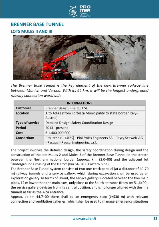
The Brenner Base Tunnel is the key element of the new Brenner railway line between Munich and Verona. With its 64 km, it will be the longest underground railway connection worldwide.
INFORMATIONS Customer Brenner Basistunnel BBT SE Location Alto Adige (from Fortezza Municipality to state border Italy-
Austria) Type of service Detailed Design; Safety Coordination Design Period 2013 - present Cost € 1.400.000.000 Consortium Pro Iter s.r.l. (40%) - Pini Swiss Engineers SA - Poyry Schweiz AG
- Pasquali-Rausa Engineering s.r.l.
The project involves the detailed design, the safety coordination during design and the construction of the lots Mules 2 and Mules 3 of the Brenner Base Tunnel, in the stretch between the Northern national border (approx. km 32.0+00) and the adjacent lot ‘Underground Crossing of the Isarco’ (km 54.0+00 Eastern pipe). The Brenner Base Tunnel system consists of two one-track parallel (at a distance of 40-70 m) railway tunnels and a service gallery, which during excavation shall be used as an exploration gallery. In terms of layout, the service gallery is located between the two main pipes, 12 m lower than the main axes; only close to the South entrance (from km 51.6+00), the service gallery deviates from its central position, and is no longer aligned with the line tunnels as far as the Aica entrance. Approx. at km 44.7+00 there shall be an emergency stop (L=530 m) with relevant connection and ventilation galleries, which shall be used to manage emergency situations

www.proiter.it 13
in case of fire. The stop is connected to the outside by means of a carriageable tunnel that runs parallel to the line tunnel for approx. 5 km and subsequently comes out onto the Mules window (L=1720 m), which connects the work to the outside. The tunnel system is completed by cross galleries that, besides providing an escape between the pipes (one approx. every 333 m), also host the technical rooms and the fire-fighting tanks. For plant-engineering and hydraulic purposes, approx. every 2000 m there shall be vertical shafts for connection of the cross galleries with the underlying service gallery. Close to the Mules window entrance there shall also be an underground ventilation station, directly connected to the outside by means of a shaft (H=60 m). From a geological point of view, the Brenner Base Tunnel develops across the main tectonic units forming the Alpine chain, with a maximum overburden of 1700 m. These units, which consist of several overlapping layers, are what remains of the collision between the European plate and the Adriatic (African) one; in the design area they form a dome, at the center of which it is possible to identify the Pennidic and Subpennidic units of the Tauern window, i.e. the deepest tectonic units that form the core of the Alps. Southward, the Brenner Base Tunnel crosses the fault zone that forms the Periadriatic Lineament, of regional relevance, which separates the Austroalpine basement from the Southern Alpine one. The line tunnels show several applied typical sections, which vary based on both the excavation method (in part using traditional methods, but mainly with the TBM) and the number of tracks (close to the adjacent lot ‘Underground Crossing of the Isarco’ both tunnels become two-track and three-track).
MAIN FEATURES OF THE ROUTE 2 line tunnels (main axes): approx. 22 km 1 service/exploration gallery: approx. 16 km 69 cross galleries with an overall length between 40 and 70 meters 1 emergency stop with relevant connection and ventilation galleries, an access
tunnel and a central gallery (approx. 4500 km) 1 carriageable window for connection with the outside (approx. 1700 meters) 3 chambers to assemble the TBM

www.proiter.it 14
TEHERAN METRO - LINE 7 SOUTH-NORTH STRETCH, LINE TUNNEL
The work concerns the design of a 9 meters diameter tunnel, approx. 13 km long, bored with mechanical excavation (TBM EPB) within the framework of the construction of the Teheran railway, Line 7 - south-north stretch - Line tunnels.
INFORMATIONS Customer Seli S.p.A. Location IRAN Type of service Detailed Design Period 2008 - 2011 Cost € 120.000.000
The work has involved engineering activities related to the construction design of the tunnel with mechanical excavation, combined with technical assistance and updating on the work in progress. A complete and feasible design had to be prepared, including a study of the interference with buildings and facilities next to the line.
www.proiter.it 15
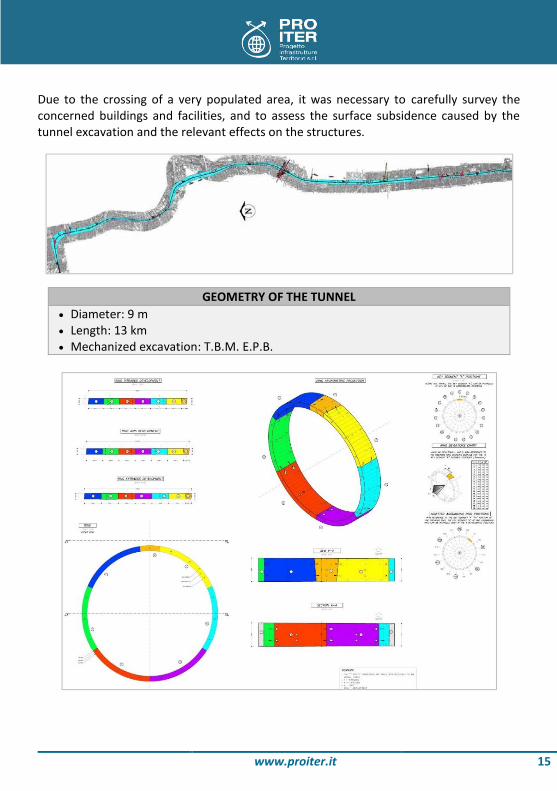
Due to the crossing of a very populated area, it was necessary to carefully survey the concerned buildings and facilities, and to assess the surface subsidence caused by the tunnel excavation and the relevant effects on the structures.
GEOMETRY OF THE TUNNEL Diameter: 9 m Length: 13 km Mechanized excavation: T.B.M. E.P.B.

www.proiter.it 16
RAILWAY TEL AVIV JERUSALEM - A1 THE TUNNELS ‘HORESH’ AND ‘HAHAMISHA’
The designed Tunnels ‘Horesh’ and ‘Hahamisha’ are part of the high-speed railway Tel Aviv-Jerusalem, linking the two most important Israel cities. This new railway link developing along 60 km of the internal regions of Israel, with both underground and open-air stretches, reduces the travel time from Tel Aviv to Jerusalem to just 28 minutes.
INFORMATIONS Customer Impresa Pizzarotti & Co. S.p.A. Location ISRAEL Type of service Preliminary and Detailed Design Period 2010 - 2013 Cost € 42.000.000
The involved area is characterized by an hilly morphology with some peaks; the geological structure is characterized by the presence of sedimentary formations related to Upper Cretaceous. The lower part of the sedimentary sequence is represented by dolomite that passes in to the limestone with marly interbeds towards the upper part; marly and chalky sediments increase in the formations of the upper part of the sedimentary sequence, where soft rocks prevail and the rock quality decreases. The Tunnels are excavated in soft rocks (mainly marl and chalk) from the western portal at km 250, and carbonate formations (mainly dolomite, limestone and marl interbeds) from km 250 to the eastern portal.
www.proiter.it 17
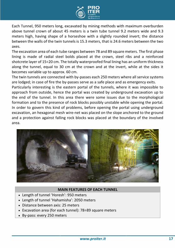
Each Tunnel, 950 meters long, excavated by mining methods with maximum overburden above tunnel crown of about 45 meters is a twin tube tunnel 9.2 meters wide and 9.3 meters high, having shape of a horseshoe with a slightly rounded invert; the distance between the walls of the twin tunnels is 15.3 meters, that is 24.6 meters between the two axes. The excavation area of each tube ranges between 78 and 89 square meters. The first phase lining is made of radial steel bolds placed at the crown, steel ribs and a reinforced shotcrete layer of 15÷20 cm. The totally waterproofed final lining has an uniform thickness along the tunnel, equal to 30 cm at the crown and at the invert, while at the sides it becomes variable up to approx. 60 cm. The twin tunnels are connected with by-passes each 250 meters where all service systems are lodged; in case of fire the by-passes serve as a safe place and as emergency exits. Particularly interesting is the eastern portal of the tunnels, where it was impossible to approach from outside, hence the portal was created by underground excavation up to the end of the tunnel. In this area there were some issues due to the morphological formation and to the presence of rock blocks possibly unstable while opening the portal. In order to govern this kind of problems, before opening the portal using underground excavation, an hexagonal mesh wire-net was placed on the slope anchored to the ground and a protection against falling rock blocks was placed at the boundary of the involved area.
MAIN FEATURES OF EACH TUNNEL Length of tunnel ‘Horesh’: 950 meters Length of tunnel ‘Hahamisha’: 2050 meters Distance between axis: 25 meters Excavation area (for each tunnel): 78÷89 square meters By-pass: every 250 meters

www.proiter.it 18
MOTORWAY BY PASS OF IMPERIA WORKS ON THE S.S.1 ‘AURELIA’ IN THE MUNICIPALITIES OF IMPERIA AND DIANO MARINA
Thanks to the new route it will be possible to decongest traffic in the town of Imperia and in particular in a very critical area where the new (and sole) railway station of Imperia is being constructed.
INFORMATIONS Customer A.N.A.S. S.p.A. Location Province of Imperia Type of service Final Design for Integrated Agreement; Environmental Impact
Assessment Period 2010 - 2012 Cost € 413.000.000 Consortium Pro Iter s.r.l. (51%) - So.Tec. s.r.l. - ProGei s.r.l. - Giugiaro Architecture
This alternative ordinary road will prevent medium and long distance traffic from transiting in the town center. A fast connection to the main roads and the most relevant urban and suburban areas shall also be ensured. In addition, this road will join the existing road network by means of junctions located in places where traffic flows are very high.

www.proiter.it 19
The route, approx. 10 km long, involves the municipalities of Imperia, Diano Castello and Diano Marina. In the municipality of Imperia it develops from the Imperia West exit of the ‘Autostrada dei Fiori’ motorway to the Imperia Est exit, both in tunnels and viaducts. At Imperia Est the route continues in tunnels as far as the San Leonardo mountain from where, in viaducts and parallel to the motorway, it enters the municipality of Diano. The territory of Diano Castello is crossed for a short stretch in the final part of the route. The various difficulties, both constructive and architectural-environmental, due to the several restraints posed by a heavily built-up territory, have been solved thanks to integrated solutions adapted to the orographic and landscape context of the surrounding environment. The definition of the works of art has been strongly influenced by the importance of the territorial context reflected in the choice of valuable constructions, in particular in the most sensitive areas. The viaduct structure ranges from mixed two-beam decks made of steel/concrete to half-through arch bridges. The tunnel entrances, located in small narrow valleys, consist of reduced length portals with continuation walls lined with natural stone. The design of the underground focusses on the aspects of user safety in case of emergency (specific plants and structures, including the presence of an escape pedestrian gallery under the road surface).
The work, due to the very nature of the areas involved, poses mainly environmental problems; although 70% of the route develops in tunnels, environmental compensations and mitigations are an issue in the open-air stretches in small valleys or heavily built-up
areas.
MAIN WORKS OF DESIGN 8 natural tunnels (total length: 7.24 km) 4 viaducts passing through valleys 9 road junctions with roundabouts at single level
www.proiter.it 20
RAILWAY LINK LAVENO-BELLINZONA DEVELOPMENT OF STUDIES FOR CHOOSING THE RAILWAY ROUTES ‘LUGANO-CHIASSO’ AND ‘GRONDA OVEST’
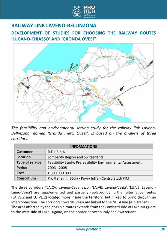
The feasibility and environmental setting study for the railway link Laveno-Bellinzona, named ‘Gronda merci Ovest’, is based on the analysis of three corridors.
INFORMATIONS Customer R.F.I. S.p.A. Location Lombardy Region and Switzerland Type of service Feasibility Study; Prefeasibility Environmental Assessment Period 2006 - 2008 Cost € 800.000.000 Consortium Pro Iter s.r.l. (55%) - Poyry Infra - Centro Studi PIM
The three corridors ('LA.CA: Laveno-Cadenazzo'; 'LA.VE: Laveno-Vezia'; 'LU.VE: Laveno - Luino-Vezia') are supplemented and partially replaced by further alternative routes (LA.VE.2 and LU.VE.2) located more inside the territory, but linked to Luino through an interconnection. The corridors towards Vezia are linked to the NFTA line (Alp Transit). The area affected by the possible routes extends from the Lombard side of Lake Maggiore to the west side of Lake Lugano, on the border between Italy and Switzerland.

www.proiter.it 21
The routes considered shall be approx. 40-50 km long and, as far as the landscape characteristics and the mainly underground altitude profile (90% in tunnel, 10% in the open air) are concerned, the interferences with inhabited areas on the surface are very seldom. Also with respect to the landscape-environmental system, which is characterized by a high natural value, the structural features adopted help to solve any critical conflicts between the new infrastructure and the landscape. The model used for the various solutions consists in supplementing the current historical line with the new single-track line, ensuring an operating performance of 120 trains a day. As to underground works, these include a main single-track tunnel and a safety gallery parallel to the main tunnel, for the safety of users. For both works, a shielded machine should be used. The study and the analysis of the corridors are based on the assessment of all critical elements for a technical-economic definition of the routes (cost, time, length, impact on the territory, working capability and train performance), in order to reach the final comparison phase based on the 'Multi-criteria analysis': thanks to this tool it is possible to compare the various route options, taking into account different criteria so as to establish a ranking of the preference levels of each option and discover the most appropriate one, which in this case is the route Laveno-Vezia with an interconnection towards Luino (LU.VE.2).
MAIN FEATURES OF DESIGN 3 located passageways and 2 layout options Length of layouts: 40÷50 km Tunnel stretches: 90% of the total One-track tunnels and safety parallel tunnel

www.proiter.it 22
MILAN TUNNEL A NEW UNDERGROUND ROAD SYSTEM TO CONNECT THE AREA NORTH OF MILAN
Pro Iter was appointed promoter of the ‘North Milan Link Route’ project in 2006. The project consisted of building a complex system of interconnected tunnels completely integrated into the surface road network in order to carry the traffic flowing from and to the city center, ease congestion of the surface road network and allow redevelopment of areas which are today in a deep state of decay, in compliance with the Milan city traffic plan guidelines.
INFORMATIONS Customer Torno Internazionale S.p.A. Location Milan Type of service Preliminary Design; Project Finance; Prefeasibility
Environmental Assessment Period 2003 - 2005 Cost € 645.700.000
The project stems from further development of the feasibility study drawn up by the Milan City Council. It entails building a 4 km long dual bore tunnel along the Motorways-Garibaldi artery using a tunnel boring machine, constructing an artificial tunnel along the Viale Monte Ceneri artery, and demolishing the existing flyover, which will allow redevelopment and environmental improvement of the surrounding area. The design pursues the following objectives: - to enhance the system of roads feeding into Milan;

www.proiter.it 23
- to make traffic along the relevant main roads more fluid; - to segregate the various modes of travel so that the local network is better available
to citizens; - to decongest urban roads by diverting and distributing the inbound and outbound
traffic.
The project was characterized by: - Attention to the choice of building methods to ensure perfect operation and long
structural life, and minimize the duration of the building operations; - Safety in the tunnel both in ordinary working conditions and in emergencies, with
particular attention to escape routes for users (construction of escape routes under the road surface and building of a road and pedestrian bypass) and tunnel air quality (aeration, and extraction and smoke treatment system in the false ceiling);
- Detailed survey of the expected repercussions of the new infrastructure on the mouth areas;
- Architectural study of the same areas so the tunnel may be correctly integrated into the urban surroundings;
- Optimization of the gradient to avoid interference with the metro and underground railway lines (existing and foreseen), and to avoid damaging the foundations of the buildings above.
MAIN THEMES OF DESIGN Construction methods Safety and air quality Detailed study of the inlets Urban integration work Optimization gradient

www.proiter.it 24
HIGHWAY BETWEEN CATANIA AND SIRACUSA COMPLETION OF THE MOTORWAY-LIKE STRETCH
The project involved completing the motorway-like stretch of road between Catania and Siracusa between Passo Martino, on the city service artery, and km 130.4 on the SS 114 main national road.
INFORMATIONS Customer Impresa Pizzarotti & Co. S.p.A. Location Provinces of Catania and Siracusa Type of service Detailed and for Construction Design Period 2004 - 2007 Cost € 533.000.000
In particular, the operations carried out regarded the geological and geotechnical assessment and geotechnical design along a 25 km section, and drawing up construction documents for 5 natural twin-bore motorway tunnels (about 11 km), 4 artificial tunnels, 20 major structures, a further 40 minor structures (manholes, watercourse crossings and underpasses with openings of up to 16 m), embankments (up to 10.5m in height) and entrenchments (up to 30 m in depth). The section includes the following tunnels (from north to south): S. Demetrio (L=2800 m), Filippella (L=1000 m), Agnone I (L=200 m), Agnone II (L=150 m) and Serena (L=1050 m). The excavation work involved rocks both of sedimentary (Monte Carruba calcarenites, Pleistocene calcarenites and the respective base conglomerate) and volcanic (Pliocene

www.proiter.it 25
volcanic rocks) origin. Lastly the heterogeneity of the rocks comprising the Carlentini formation (Upper Miocene) should be mentioned. For long sections of boring, this entailed passing through fronts of ‘mixed lithotypes’, characterized by contact between rocks with different geomechanical characteristics. A full-section excavation method was constantly used (average cross-sectional area of 160 m2), mainly utilizing mechanical means. After every breakthrough, preliminary stage linings were applied (shotcrete and nails in the crown or shotcrete, steel ribs and nails in the side walls). The geomechanics of the rocks made excavation consolidation with GFRP-RC beams necessary along isolated stretches only. Excavation started at the north mouth of the S. Demetrio tunnel in Spring 2005. The two bores of the S. Demetrio tunnel were the only ones excavated by working on two opposite fronts; the other tunnels were almost entirely excavated by working in parallel along both bores in the same direction. The last wall of rock (north bore of the Filippella tunnel) came down on 24 May 2007.
MAIN WORKS OF DESIGN 5 natural tunnels 4 artificial tunnels 20 major works 40 minor works
www.proiter.it 26
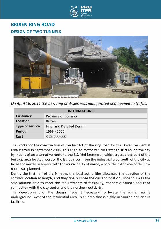
BRIXEN RING ROAD DESIGN OF TWO TUNNELS
On April 16, 2011 the new ring of Brixen was inaugurated and opened to traffic.
INFORMATIONS Customer Province of Bolzano Location Brixen Type of service Final and Detailed Design Period 1999 - 2005 Cost € 25.000.000
The works for the construction of the first lot of the ring road for the Brixen residential area started in September 2006. This enabled motor vehicle traffic to skirt round the city by means of an alternative route to the S.S. ‘del Brennero’, which crossed the part of the built-up area located west of the Isarco river, from the industrial area south of the city as far as the northern border with the municipality of Varna, where the extension of the new route was planned. During the first half of the Nineties the local authorities discussed the question of the corridor location at length, and they finally chose the current location, since this was the sole solution able to meet the requirements of feasibility, economic balance and road connection with the city center and the northern outskirts. The development of the design made it necessary to locate the route, mainly underground, west of the residential area, in an area that is highly urbanized and rich in facilities.
www.proiter.it 27
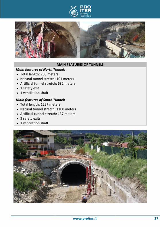
MAIN FEATURES OF TUNNELS Main features of North Tunnel: Total length: 783 meters Natural tunnel stretch: 101 meters Artificial tunnel stretch: 682 meters 1 safety exit 1 ventilation shaft
Main features of South Tunnel: Total length: 1237 meters Natural tunnel stretch: 1100 meters Artificial tunnel stretch: 137 meters 3 safety exits 1 ventilation shaft

www.proiter.it 28
‘LE CROCI’ AND ‘CASE FORNO’ TUNNELS ON A1 MOTORWAY EXPANSION IN THE 3RD LANE IN BARBERINO DEL MUGELLO - FLORENCE NORTH
The Le Croci and Case Forno tunnels are part of the project to widen the A1 Milan-Naples motorway to three lanes along the Barberino del Mugello-Florence North stretch.
INFORMATIONS Customer SPEA Ingegneria Europea S.p.A. Location Tuscan-Emilian Apennines Type of service Detailed Design Period 2006 - 2009 Cost € 119.000.000
The project entails building a new southbound carriageway along a different route to the existing one. It consists of a series of very long tunnels equipped with an underground passage under the road surface for safety and other systems. The Le Croci tunnel is a total of about 1670 m long and has an underground escape passage between the invert and the road surface. The road surface is connected with the underground passage via special pedestrian passages found in safety niches suitably

www.proiter.it 29
equipped for emergencies. The rock formations encountered in building the Le Croci tunnel consist essentially of Monte Morello (alternate marly limestones, malms, clay marls and laminated argillites) and the argillites in the Sillano area (alternate highly laminated marly slates and calcarenites) in their various facies. The water table is above the height of the crown almost everywhere. The maximum ground cover is about 90 m, and the minimum (2 m approx.) is found at a fault in Monte Morello. An intermediate service tunnel is to be dug in this area, which is just before the existing A1 underpass, to create an artificial lay-by and bypass link road with the other motorway carriageway. The adjoining Case Forno tunnel is to have an overall length of about 193 m and will also house the new southbound carriageway. The tunnel passes through high ground about 370 m above sea level with substrates consisting of argillites belonging to the Sillano formation, under its alteration horizon consisting of a layer nearer the surface of eluvial-colluvial deposits.
MAIN FEATURES OF TUNNELS Main features of ‘Le Croci’ tunnel: Natural tunnel Total length: 1670 meters Artificial window for parking area and vehicular bypass
Main features of ‘Case Forno’ tunnel: Artificial tunnel Total length: 193 meters

www.proiter.it 30
HYDRO INSTALLATION ON VAL BOITE NEW INSTALLATION IN THE PROVINCE OF BELLUNO
The design concerns a new run-of-river hydroelectric installation that shall be set up along the Boite torrent in the province of Belluno, with an offtake regulator in the municipality of Cortina d’Ampezzo and a power station in the municipality of Borca di Cadore, along the Vodo artificial lake.
INFORMATIONS Customer Dolomiti Derivazioni s.r.l. Location Municipalities of Cortina d'Ampezzo, Borca di Cadore, Vodo di
Cadore and San Vito di Cadore Type of service Final Design; Environmental Impact Assessment Period 2009 - 2010 Cost € 85.900.000
This final design, along with the environmental impact study, is attached to the application for the granting of water supply for hydro-electric purposes, according to applicable law. The run-of-river hydro installation has a very simple scheme: it consists of a single offtake regulator, located on the Boite torrent in the southern part of the municipality of Cortina d'Ampezzo, just downstream of the point where the brook Federa runs into the Boite. The diverted waters - after being processed to remove sand - run from the offtake regulator into a long natural tunnel (approx. 12.1 km), and reach a filling construction,

www.proiter.it 31
from where a 725 m long buried pressure pipe conducts water to the power station located by the Vodo lake in the municipality of Borca di Cadore. Here water is whirled by two Francis units and returned to the Boite torrent through a short drainage ditch.
FEATURES OF HYDROELECTRIC PLANT Maximum flow to derive: 13.5 mc/s Total annual volume: 182'467'549 mc Average flow to derive: 5.79 mc/s Permanent flow released (DMV): 1.148 mc/s Expected annual production: 103.7 GWh/anno

www.proiter.it 32
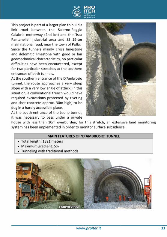
ISCA PANTANELLE - POLLA ROAD ‘D'AMBROSIO’ AND ‘LEONE’ TUNNELS
Detailed design and construction documents with site assistance during the building of the underground structures between km 6.199 and the end of the lot: two tunnels with an overall length of about 6 km.
INFORMATIONS Customer Consorzio Cosviter Location Province of Potenza Type of service For Construction Design; Geological-Geotechnical Design with
Site Assistance Period 1998 - 2005 Cost € 24.300.000
www.proiter.it 33
This project is part of a larger plan to build a link road between the Salerno-Reggio Calabria motorway (2nd lot) and the ‘Isca Pantanelle’ industrial area and SS 19-ter main national road, near the town of Polla. Since the tunnels mainly cross limestone and dolomitic limestone with good or fair geomechanical characteristics, no particular difficulties have been encountered, except for two particular stretches at the southern entrances of both tunnels. At the southern entrance of the D'Ambrosio tunnel, the route approaches a very steep slope with a very low angle of attack; in this situation, a conventional trench would have required excavations protected by riveting and shot concrete approx. 30m high, to be dug in a hardly accessible place. At the south entrance of the Leone tunnel, it was necessary to pass under a private house with less than 10m overburden; for this stretch, an extensive land monitoring system has been implemented in order to monitor surface subsidence.
MAIN FEATURES OF ‘D’AMBROSIO’ TUNNEL Total length: 1821 meters Maximum gradient: 5% Tunneling with traditional methods
www.proiter.it 34
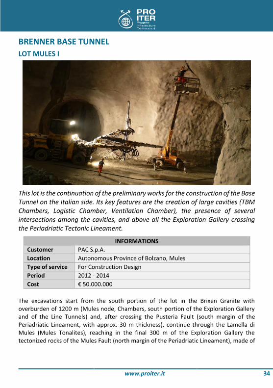
BRENNER BASE TUNNEL LOT MULES I
This lot is the continuation of the preliminary works for the construction of the Base Tunnel on the Italian side. Its key features are the creation of large cavities (TBM Chambers, Logistic Chamber, Ventilation Chamber), the presence of several intersections among the cavities, and above all the Exploration Gallery crossing the Periadriatic Tectonic Lineament.
INFORMATIONS Customer PAC S.p.A. Location Autonomous Province of Bolzano, Mules Type of service For Construction Design Period 2012 - 2014 Cost € 50.000.000
The excavations start from the south portion of the lot in the Brixen Granite with overburden of 1200 m (Mules node, Chambers, south portion of the Exploration Gallery and of the Line Tunnels) and, after crossing the Pusteria Fault (south margin of the Periadriatic Lineament, with approx. 30 m thickness), continue through the Lamella di Mules (Mules Tonalites), reaching in the final 300 m of the Exploration Gallery the tectonized rocks of the Mules Fault (north margin of the Periadriatic Lineament), made of

www.proiter.it 35
a disorderly succession of shale carbons, tectonized paragneiss, quartzite, anhydrites with subvertical arrangement of the various portions. To cross the tectonized areas, special excavation sections have been designed, taking into account the potential mass deformations and the development of significant loads resulting from the poor characteristics of the material and the 600-700 m high overburden.
MAIN FEATURES OF DESIGN Twin rail tunnels at single track (L=2x1200 meters), approx. 10 meters in size
excavation with conventional methods, connected with 3 transversal by-pass Exploration Gallery (L=1200 meters), approx. 6 meters in size excavation with
conventional methods 2 chambers for TBM (180 meters long, 22 meters in diameter, 18 meters high) Logistic chamber (L=40 meters, D=20 meters, H=18 meters) Ventilation chamber (L=20 meters, H=18 meters), connected to outside with an
air shaft (D=6 meters, H=47 meters) and connected at 'Mules Window' with 2 branches gallery (dimensions: 11x10 meters)
Various tunnels of the underground logistic node of Mules

www.proiter.it 36
BRENNER BASE TUNNEL PRELIMINARY LOT AICA-MULES
In a first step, the work has involved the detailed design of the Exploration Gallery Aica-Mules. Subsequently, during the preparation of the construction documents, the Mules Window was redesigned in order to adapt dimensions to the new needs resulting from the ventilation system of the Base Tunnel. Finally, during works, the following steps were planned: restoration and reinforcement of the coating as well as consolidation of the rock mass after the accident occurred approx. at chainage km 6.5 of the Gallery, where the fault zone of Rio Bianco is crossed, which had resulted in collapse of approx. one hundred meters of rings made of pre-cast segments and in the shield being stopped.
INFORMATIONS Customer Brenner Basistunnel BBT SE Location Autonomous Province of Bolzano Type of service Detailed and for Construction Design Period 2005 - 2010 Cost € 80.000.000 Consortium Pro Iter s.r.l. (30%) - Pasquali Rausa Engineering s.r.l. - SWS
Engineering s.r.l. The Exploration Gallery serves both for geologic-geomechanical prospecting during works, for logistic purposes (drainage and discharge of groundwater, conveying of excavated material, logistic access to the south yard), and for serving the Base Tunnel during operation.

www.proiter.it 37
The design has been completed with the development of a monitoring, prospecting, measurement and survey campaign in order to allow the subsequent proper design of the Base Tunnel. The Mules Window is a winze with approx. 10% slope, allowing access to the Base Tunnel from the main excavation site. The Unterplattner tunnel is used to convey the excavated material to the main deposit of Hinterrigger during works. The excavations are entirely located in the so-called Brixen Granite, except for those for the Unterplattner tunnel (Brixen quartziferous Phyllites). The overburden reaches 1200 m.
MAIN FEATURES OF DESIGN Exploration gallery Aica-Mules: excavation with double-shield TBM system
(L=10'500 meters, D=6 meters, lining rings made of pre-cast segments) 'Mules Window': excavation with conventional methods (L=1750 meters, H=9
meters, 10 meters width) Unterplattner tunnel: excavation with conventional methods (L=650 meters,
H=7 meters, 7 meters width)

www.proiter.it 38
ACCESS SYSTEM TO THE EXPO 2015 AREA NEW ROUTE LINKING THE WESTERN BY-PASS ROAD A50 AND THE A8 MOTORWAY
The design is part of the complex set of upgrading and territorial innovation actions promoted at the Universal Exposition 2015, aimed at enhancing the Lombard territory as a whole and, in particular, at ensuring the necessary access roads.
INFORMATIONS Customer Eureca Consorzio Stabile (for Infrastrutture Lombarde S.p.A.) Location Milan Type of service Final, Detailed and for Construction Design Period 2012 - 2015 Cost € 120.000.000 Consortium Pro Iter s.r.l. (43%) - Politecnica - Erre.Vi.A. s.r.l. - Antonio
Citterio & Partners The design pursues full integration of the exhibition center Expo 2015 with the territory, ensuring proper access to the site by means of an expressway with approx. 3 km length, located northwest of Milan, close to the new Exhibition Center in Rho-Pero. From a merely road perspective, the link is a natural continuation of the alternative route to the S.S. 11 'Padana Superiore' in the municipality of Milan, as it originates from the intersection of the latter with the S.S. 33 'del Sempione'. During the upgrading stage, the route initially develops in an artificial tunnel passing under the area of the Integrated Intervention Plan in Cascina Merlata; then it joins the design roads for the new junction on the A4 Milan-Turin as well as with a primary municipal road under development in the municipality of Milan (interdistrict road). Subsequently, passing

www.proiter.it 39
over the FS railway station Milano Certosa of the Milan-Novara line, the A4 motorway and the EXPO 2015 area, it ends with a partial junction on the A8 'Milano Laghi' motorway in north direction. The layout has been designed in such a way that, in the future, an extension would be possible to reach the S.S. 233 'Varesina' and the SP 40 'Rho-Monza'. The main works included in the design are the artificial tunnel passing under the area of the Integrated Intervention Plan in Cascina Merlata and the viaduct originating south of the intersected railway line and ending at the A8 motorway. Built with the characteristic excavation method 'Milan type' (which allows to minimize construction times and impact on the territory during the works) and the innovative system of the 'white tank' (thanks to which waterproof concrete can be obtained already during processing), the artificial tunnel develops for approx. 1 km, bypassing the S.S.33 del Sempione and joining the roads leading to the Western by-pass road at Molino Dorino.The system of bridges and viaducts is made of a series of steel arches: for the bridges on the A4 and A8 motorways, these elements have a structural function; while along the EXPO viaduct they only have an aesthetic function, aimed at making the whole project look organic and well fitted into the urban context of 'EXPO 2015' and creating the so-called 'Door of Milan' (a distinctive element for those who drive on the road from and to the city center). The whole elevated system is made even more homogeneous and characteristic by the covering 'guard' of the decks, an external metal coating of Alucobond that ensures continuity among the works. Thanks to specific lighting studies, the presence of this element helps create an appealing play of light during the evening and in the night.
MAIN WORKS OF DESIGN Artificial tunnel Cascina Merlata: length approx. 1 km; total width 24.70 meters
(2 pipes per driving direction + central gallery) EXPO viaduct: total length 265 meters; 5 spans (53 meters each); mixed
steel/concrete structure; coated with Alucobond panels Aesthetic arches EXPO (‘Door of Milan’): 2 asymmetric arches 21m (L1=200m,
L2=197m) of Corten steel Arched bridges: bridge on the A4 (L=140m, H=35m) and bridge on the A8
(L=97m, H=35m) coated with Alucobond panels RFI viaduct: 2 adjacent decks of steel/concrete, width approx. 210 meters with
4 spans Overpass on the roundabout ‘Merlata’: 2 single-span decks, width 41 meters
(South) and 31 meters (North), coated with Alucobond panels Single-lane viaducts: viaduct ES (L=106m, 2 spans) and viaduct EN (L=56m,
single span) coated with Alucobond panels

www.proiter.it 40
NEW MILAN OUTER EASTERN BY-PASS (T.E.E.M.) A ROAD SYSTEM FOR MILAN, WIDER THAN THE CURRENT ONE
A design aimed at solving more effectively the traffic problems in one of the busiest areas in Italy. A work that will absorb more than 75,000 vehicles per day, 35,000 of which from local traffic, thereby saving 9 million driving hours p.a. A state-of-art achievement in terms of structural features and environmental friendliness.
INFORMATIONS Customer Tangenziale Esterna S.p.A. Location Provinces of Milan, Lodi, Monza & Brianza Type of service Preliminary, Final and Detailed Design Period 2002 - 2012 Cost € 1.200.000.000 Consortium Pro Iter s.r.l. (15%) - SPEA Ingegneria Europea S.p.A. - SINA
S.p.A. - Technital S.p.A. - GIRPA S.p.A. The TEEM and the relevant road system have been designed to provide a concrete answer to the need for fast and safe travels with a low environmental impact in the Eastern area of Milan. They are an integral part of the enhancement of the Milan and Lombard road system, together with the Autostrada Pedemontana Lombarda and the Direttissima Brescia-Bergamo-Milano. The new infrastructure shall directly connect the A4 motorway Turin-Trieste (through the junction of Agrate Brianza) with the A1 motorway Milan-Bologna (in the municipality of Cerro al Lambro), developing over a route of total 32 km. The design of the work envisages a three-lane layout per driving direction with an emergency lane; in addition, the most modern technologies shall be used to ensure maximum safety for travelers and to reduce sound and environmental pollution.

www.proiter.it 41
The TEEM route shall be interconnected with the existing and planned motorways (A1 Milan-Bologna, Bre.Be.Mi. and A4 Turin-Trieste) and also with the ordinary road network in the area (through junctions in Pessano con Bornago, Gessate, Pozzuolo Martesana, Liscate, Paullo and Vizzolo Predabissi). In addition to the motorway route, the design includes 19 modifications of the interconnected secondary road system ('related works') in order to upgrade and implement the major existing crossing roads, providing an infrastructure fully integrated in the territory and significantly improving the road standards and connections between primary and secondary network. Therefore, the design phase of the related works has focused on upgrading and improving the major existing roads, connecting them, if necessary, to the new motorway road and facilitating connection of the latter with the relevant areas in order to decongest the secondary network (otherwise highly penalized). During the design phase, besides the correct choice of the roadway type (based on the features and conformation of the crossed territory), special attention was paid to environmental protection, with notable works of sound insulation and protection of the hydrographic network and the irrigation canals. In addition, several environmental compensations have been introduced, with several areas turned into green spaces with naturalistic function, a proper 'soft mobility' and the identification and design of new footway and cycle lanes.
MAIN FEATURES OF THE ROUTE 32 km motorway stretch 38 km new major roads 15 km upgrading of existing major roads 30 km new cycle lanes 6 interconnection junctions 16 km sound barriers 120 hydraulic works 260 hectare green areas

www.proiter.it 42
S.S.64 ‘PORRETTANA’ MODERNIZATION OF THE MAIN ROAD SUBJECT TO LANDSLIDES
Modernization works of the main road subject to landslides between Silla and Marano in the municipality of Gaggio Montano (2nd sector between Ca’ dei Ladri and Marano).
INFORMATIONS Customer Coopsette Soc. Coop. Location Gaggio Montano Type of service Detailed Design; Environmental Impact Assessment; Safety
Coordination Design Period 2007 - 2008 Cost € 61.120.000 Consortium Pro Iter s.r.l. (73%) - Studio Matildi
The modernization of the S.S.64 ‘Porrettana’ is mainly focused on the 2nd sector (Ca’ dei Ladri-Marano) to which the design of Pro Iter - Studio Matildi refers: this sector, which is located between a sector already completed and one to be still implemented, includes areas where gravitational slope movements have mainly occurred over time (the roadway, at km 41+700 and for approx. 100m, was clearly lowered); in addition, the Reno river is visibly subject to bank erosion for long stretches along the route. The infrastructure includes 6 viaducts with several spans, developing from 100m to 725m, three artificial tunnels, a number of supporting works such as walls and bulkheads, and a significant stabilization work of the slope subject to landslides. The most critical aspect of the design is the presence of an active landslide at viaduct 2bis, where the erosive action of the Reno river has soon caused gravitational movements. In order to verify its state of activity and to determine its depth and speed of movement, inclinometric pipes have been installed during the additional geognostic survey (the
www.proiter.it 43
monitoring lasted approx. 1 year, and it continued during the entire construction phase). The designed stabilization included reinforcement works, surface and deep drainage (3 well drains and relevant draining system) and a bank protection made of boulder-size stones. A post-operam monitoring was also implemented to check effectiveness of the work performed. The longitudinal development of the route, in line with the criteria of the Final Design for Integrated Contract, is approx. 5.30 km (2.40 km viaduct, 0.50 km artificial tunnel and 2.40 km open air). The junctions in Grizzana and Marano are also included, which have been rationalized during execution to limit the burdensome and problematic adaptations of existing works, as well as to adapt to the changes of altitude of the route (necessary according to the hydraulic compatibility study performed). The viaduct piers have indirect well foundations for the piers located in the active bed of the Reno and pile or deep well foundations based on the geomorphic context: the most suitable solution was selected on a case-by-case basis according to in-depth studies on the slope behavior.
MAIN FEATURES AND KEY WORKS Significant stabilization of the slope subject to landslides by means of a deep
and surface draining system, accompanied by a monitoring ante-operam, during execution and post-operam
Bank restoration of the Reno river in agreement with the Reno River Technical Service, made with boulder-size stones
6 viaducts with several span and mixed steel/concrete structure (length between 100 m and 725 m) and indirect pile or deep foundations
2 artificial road tunnels (length 150 m and 270 m) Long stretches with supporting works, opposite bank and retaining wall made
with various technologies (cast in place, pre-cast solutions, coated bulkheads with large diameter piles, etc.)
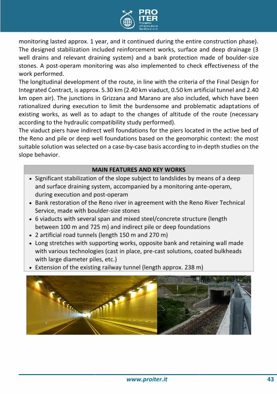
Extension of the existing railway tunnel (length approx. 238 m)

www.proiter.it 44
A1 MOTORWAY: MOUNTAIN PASS BYPASS UPGRADING OF THE APENNINE STRETCH BETWEEN SASSO MARCONI AND BARBERINO DEL MUGELLO
The construction drawings concerned were part of the overall upgrading of the A1 Milan-Naples motorway. They regarded lot 5B, which is an integral part of the Apennine stretch upgrading between Sasso Marconi and Barberino del Mugello.
INFORMATIONS Customer C.M.B. Carpi - Lagaro S.C.A.R.L. Location Val di Sambro Type of service Detailed Design Period 2005 - 2007 Cost € 114.000.000 Consortium Pro Iter s.r.l. (40%) - Politecnica - Electrowatt Infra AG
The lot considered starts inside the Val di Sambro tunnel and ends up near the south mouth of the Grizzana tunnel (lot 5A). It has a total length of about 2412 m. The motorway has two carriageways, each consisting of two traffic lanes and an emergency lane in each direction.

www.proiter.it 45
The main structures which make up the project are the Val di Sambro tunnel and the Lagaro viaduct (L=1200 m approx.). The open stretch winds along the right bank of the Torrent Setta, where solutions were found to the considerable stability problems in the area, characterized by landslides and various types of instability. Considerable consolidation work was carried out to make the infrastructure safe and shafts were dug to house the viaduct foundations. Besides the main road branch, the project includes two service roads to connect the ordinary road network to ‘campo Lagaro’, and other accessory and complementary works (snow clearance vehicle bypass to create a link between the two motorway carriageways so that service and/or emergency vehicles may turn round, VS2 and VS5 service roads to allow traffic caused by the works to flow away, and protection of the banks of the Torrent Setta).
MAIN WORKS OF DESIGN Viaduct ‘Lagaro’: 2 separated decks, built to composite steel and concrete
structure; 12 spans; total length 1161 m (North) and 1195 m (South) Artificial tunnel ‘Val di Sambro’ Natural tunnel ‘Val di Sambro’: 2 separated pipes (North length: 864 m; South
length: 868 m)

www.proiter.it 46
FLORENCE NORTH RING ROAD REORGANIZATION OF THE BYPASS NETWORK
The project aims to create a ring road system around Florence and restore the old city road system arteries to their urban role of service and exchange routes for local traffic.
INFORMATIONS Customer Florence Municipality Location Florence Type of service Feasibility Study Period 2006 Cost € 1.000.000.000
The geognostic surveys and consequent design process set out to achieve maximum integration with the aims of urban redevelopment and overall reorganization of city districts and the road system. The corridor singled out for the alternative proposed routes passes at a tangent to the city of Florence, with origin between Piana di Castello and the Lippi Barsanti district north/north-west of Piana di Castello, and ends up near the Varlungo area.
www.proiter.it 47
The system examined, which was to complete the existing infrastructure network, led to the proposal of three possible alternatives. On the whole, the infrastructures designed were type "B" according to the standards laid down in the Departmental Order of 5 November 2001 and consisted of two separate carriageways each with two 3.75 meter wide traffic lanes and 1.75 meter side verges. Besides complying with a strict analysis of the complex regional planning system, the process of defining the proposed routes was based on a large number of existing surveys including the following: - geology, geomorphology and geotechnical characteristics of the land crossed (with
support assessments drawn up by the Department of Earth Sciences of the University of Florence);
- hydraulic problems (river crossings, drainage criteria and roadbed water destination); - naturalistic aspects; - urban and hill landscape (visual and perceptive features, and guarantee of present
use). Once the different alternative routes were identified, the feasibility study involved carrying out analyses and a multicriteria assessment.
MAIN FEATURES OF PROPOSAL LAYOUT ‘Upper’ layout option: Total length: about 11.3 km (9.71 km in underground) 2 tunnels (‘Careggi’, 4755 meters long; ‘Fiesole’, 4955 meters long) 2 junctions (Castello, Coverciano)
‘Middle’ layout option: Total length: about 10.6 km (7.91 km in underground) 4 tunnels (‘Careggi’, 2935 meters long; ‘Le Fonti’, 140 meters long; ‘La Lastra’,
630 meters long; ‘Fiesole’, 4740 meters long) 4 junctions (Castello, Bolognese, Faentina, Coverciano) 1 viaduct (‘Mugnone’, 80 meters long)
‘Lower’ layout option: Total length: about 10.1 km (7.62 km in underground) 3 tunnels (‘Careggi’, 3015 meters long; ‘La Lastra’, 570 meters long; ‘Fiesole’,
4030 meters long) 4 junctions (Castello, Bolognese, Faentina, Coverciano)

www.proiter.it 48
NEW ROUTE FOR THE S.S. 106 ‘JONICA’ UPGRADING AND WIDENING WORKS ON THE S.S. 106 IN THE PROVINCE OF REGGIO CALABRIA
The project is materially subdivided into two sections, and is characterized by a high number of structural works underground (tunnels) and in the open air (viaducts).
INFORMATIONS Customer A.N.A.S. S.p.A. Location Province of Reggio Calabria Type of service Preliminary Design; Feasibility Study; Environmental Impact
Assessment Period 2004 - 2007 Cost € 2.240.000.000 Consortium Pro Iter s.r.l. (80%) - Electrowatt Infra AG
The new route for the existing S.S. 106 'Jonica', in the sections Melito Porto Salvo - Palizzi and Bova Marina - S. Ilario (in the province of Reggio Calabria), is a part of the E90 European route, and it represents one of the functional mega-lots that make up the important route of quick regional communication between the towns along the Ionian coast, from Reggio Calabria to Taranto. Section 1 starts downstream of the crossing of the Melito torrent in the Prunella district (where it connects to the previous ML05 mega-lot), and it ends in the San Pasquale district, where it connects to the existing S.S. 106: over its length of approx. 16 km it has 4 junctions, 14 viaducts (among which the 'Amendolea' viaduct with 43 spans and a total length of 1.642 meters) and 16 two-pipe tunnels (among which the 'Bova II' tunnel, which extends for approx. 1.8 km). Section 2 starts 1.5 km west of Spopolo, and it ends in the S. Ilario district north of Ardore Marina: over its length, which slightly exceeds 37 km, it has 5 junctions, 28 viaducts (among which the 'Careri' viaduct with 44 spans and a total length of 2.566 meters) and

www.proiter.it 49
23 two-pipe tunnels with a length ranging from 1.540 meters of the 'Principe' tunnel to 95 meters of the 'Vurgia' tunnel. Thanks to this work, it will be possible to move transiting traffic outside the urban areas, and to maintain only the local functions on the current route, so that these areas can experience a significant improvement in environmental terms.
MAIN FEATURES OF DESIGN Main features Line 1: Total length: about 16 km 4 junctions 14 viaducts 16 twin-tube tunnels
Main features Line 2: Total length: about 37 km 5 junctions 28 viaducts 23 twin-tube tunnels

www.proiter.it 50
ALBENGA-GARESSIO-CEVA MOTORWAY NEW ROAD SYSTEM CONNECTING PIEMONTE AND LIGURIA
The study is aimed at creating a road system able to improve the road links between the regions of Piemonte and Liguria, which are currently characterized by a high number of accidents and lack of easy mobility (which is a pre-requisite for economic growth).
INFORMATIONS Customer Autostrada Albenga Garessio Ceva S.p.A. Location Provinces of Savona and Cuneo Type of service Feasibility Study; Environmental Impact Assessment Period 2006 Cost € 2.034.000.000 Consortium Pro Iter s.r.l. (70%) - SO.TEC. s.r.l. - Studio3 Ingegneri Associati
The identified corridor, where the alternative route proposals are located, extends along the Neva (Savona) and Tanaro (Cuneo) river valleys, starting from near the Albenga junction on the A10 Ventimiglia-Savona motorway and ending near the Ceva junction on the A6 Torino-Savona. The system under study, which shall supplement the existing

www.proiter.it 51
infrastructural network, has resulted in the identification of 3 possible alternatives: the project infrastructure consists of 2 distinct carriageways, each one having two driving lanes of 3.75 m and an emergency lane of 3 m. The contents of the feasibility study have been developed with a special focus on the following issues: - territorial and socio-economic setting of the corridor, with a special focus on
geological, traffic (characteristics and distribution of the network and of mobility infrastructures) and environmental issues (presence of parks and protected areas, watercourses and relevant basins);
- traffic study, result of supplementary surveys and simulations related to the considered transport scenarios;
- methodology for the development of the routes and relevant alternatives, measurement and geometrization of the infrastructure and works;
- technical-economic analysis of the routes and definition of the economic feasibility of the work;
- analysis of the main impacts on the environment and territory; - multi-criteria analysis of route alternatives.
LAYOUT DESIGNED Features of Layout A: Total length: about 19 km Trench road sections: 51% Tunnel sections (natural and artificial): 18% Viaduct sections: 31% 2 junctions (toll booths) 1 junction to motorway link
Features of Layout B: Total length: about 26.7 km Trench road sections: 17% Tunnel sections (natural and artificial): 72% Viaduct sections: 11% 1 junction to motorway link
Features of Layout C: Total length: about 26 km Trench road sections: 6% Tunnel sections (natural and artificial): 90% Viaduct sections: 4% 1 junction to motorway link
www.proiter.it 52
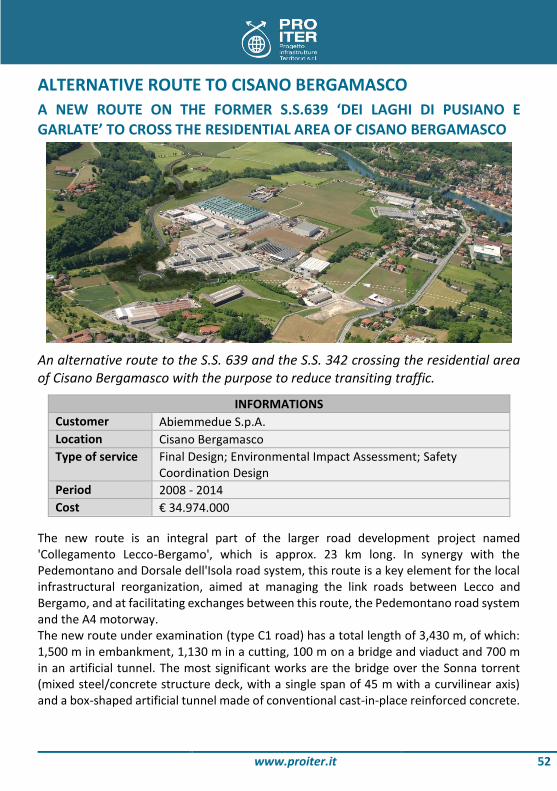
ALTERNATIVE ROUTE TO CISANO BERGAMASCO A NEW ROUTE ON THE FORMER S.S.639 ‘DEI LAGHI DI PUSIANO E GARLATE’ TO CROSS THE RESIDENTIAL AREA OF CISANO BERGAMASCO
An alternative route to the S.S. 639 and the S.S. 342 crossing the residential area of Cisano Bergamasco with the purpose to reduce transiting traffic.
INFORMATIONS Customer Abiemmedue S.p.A. Location Cisano Bergamasco Type of service Final Design; Environmental Impact Assessment; Safety
Coordination Design Period 2008 - 2014 Cost € 34.974.000
The new route is an integral part of the larger road development project named 'Collegamento Lecco-Bergamo', which is approx. 23 km long. In synergy with the Pedemontano and Dorsale dell'Isola road system, this route is a key element for the local infrastructural reorganization, aimed at managing the link roads between Lecco and Bergamo, and at facilitating exchanges between this route, the Pedemontano road system and the A4 motorway. The new route under examination (type C1 road) has a total length of 3,430 m, of which: 1,500 m in embankment, 1,130 m in a cutting, 100 m on a bridge and viaduct and 700 m in an artificial tunnel. The most significant works are the bridge over the Sonna torrent (mixed steel/concrete structure deck, with a single span of 45 m with a curvilinear axis) and a box-shaped artificial tunnel made of conventional cast-in-place reinforced concrete.

www.proiter.it 53
The project pays special attention to the following issues: - road safety and functionality; - tunnel safety (routine and emergency management); - connections with the existing road network; - setting up of building yards and relevant executive phases, in order not to penalize
the functionality of the crossing roads; - soil balancing, with lime soil stabilization, thanks to which it is possible to use the
excavated material again for road embankments; - landscape and environment, with a special focus on the protection of surface and
underground water, sound insulation and landscape setting (a large part of the route crosses the 'Parco Adda Nord').
MAIN WORKS OF DESIGN Bridge on Sonna creek: 46 meters long (single span), 220 meters bending
radius, steel/concrete structure, 14.75 meters wide 2 artificial tunnels opencast built: ‘Cisano’ tunnel (640 meters long, 14 meters
wide, with emergency exit, technical rooms and fire system) and ‘Tre Fontane’ tunnel (55 meters long, 12.63÷15.19 meters wide), box section in reinforced concrete
‘Colombera street’ underpass: box section, 14.6 meters long, 10 meters wide

www.proiter.it 54
VICENZA TUNNEL UNDERGROUND WORKS FOR THE MONTI BERICI UNDERPASS
The project entailed building an underpass under the city of Vicenza in order to relieve city road network congestion and to act as an artery which reorganizes the whole Vicenza area road network.
INFORMATIONS Customer CO.GEN.CO. Location Vicenza Type of service Project Finance Period 2004 - 2005 Cost € 133.900.000
The system consisted of three different stretches: - Main east-west artery (L = 4.0 km); - Link road to the industrial area; - Link road to the railway station and alteration of Mazzini boulevard. The most characteristic structure in the project is the ‘Berici’ tunnel: it is a two-way single bore with 8.00 m wide roadbed (total length of 1866 m).

www.proiter.it 55
The most problematic aspect tackled when drawing up the design was the change in height in the tunnel, which had to take the following into account: - The need to keep as much of the route over the ground-water table as possible in
order to use excavation sections without inverts (cost reduction); - The need to pass under the high speed line being designed; - The need to pass under the River Retorto and River Bacchiglione, whose beds are
about 7 m lower than the natural surface level; - The need to implement longitudinal gradients which are not excessively steep in order
to limit exhaust gases and minimize the flow rates of the ventilation systems required; - The need to place the lay-bys outside the sections under the water table to keep
building costs down. Given the length of the tunnel, a design solution to evacuate users in the event of fire was proposed. It entailed building an underground passage between the road surface and the invert, with internal dimensions of 3.00 x 2.30 m, connected to the carriageway at special access points every 150 m. This proposal ensures that users may reach a safe smoke-free escape route on foot in the event of fire within a maximum distance of 75 m.
MAIN FEATURES OF ‘I BERICI’ TUNNEL Bidirectional bore Total length: 1866 meters Total wide: 8 meters Evacuation tunnel in case of fire (entryways every 150 meters)

www.proiter.it 56
INTERMODAL CORRIDOR ROME-LATINA CASTEL ROMANO-APRILIA NORD LINE
The proposed work (Pontino Rome – Latina Integrated Intermodal System) falls within the context of a new design for a north-south motorway corridor, necessary to decongest the Apennine stretch and to create cross connections between the Tyrrhenian coast and the Adriatic one.
INFORMATIONS Customer Arcea Lazio S.p.A. Location Provinces of Rome and Latina Type of service Final Design Period 2005 Cost € 291.000.000 (Intermodal Corridor Rome-Latina)
€ 184.860.000 (route Cisterna-Valmontone)

www.proiter.it 57
The C.I.R.L. highway covers about 20 km, with cross-section of 2 lanes in each direction of 3.75 m and 2 emergency lanes of 3.00 m; alongside the highway through almost all of the development project run complanar roads (2 lanes in each direction of 3.50 m). It is also provided the creation of a new junction at Castel Romano and a section to bypass the town of Pomezia. The route is characterized by the following main structures : 22 bridges for a total of about 4620 m, with a deck consisting of four beams, spans 35 m long, four tunnels for a development of 300 m, 8 flyovers, 5 underpasses. The route ‘Cisterna-Valmontone’ connects the Rome-Latina project to the A1 motorway and runs for about 11 km, with cross-section of two lanes in each direction of 3.75 m and platforms of 1.75 m. The crossing of the A1 motorway will be solved with a cloverleaf junction in a split-level. The route is characterized by the following main structures: 8 viaducts, for a total of about 3280 m, with a deck consisting of four beams, spans from 35 m to 20 m long, 2 flyovers, 8underpasses.
MAIN FEATURES OF DESIGN Main features of Rome-Latina Line: Total length: 20 km 22 viaducts (total length 4620 meters) 4 artificial tunnels (total length 300 meters) 8 overpasses 5 underpasses
Main features of Cisterna-Valmontone Line: Total length: 11 km 8 viaducts (total length 3280 meters) 2 overpasses 8 underpasses

www.proiter.it 58
VIA DEL NORD’ TUNNEL REORGANISATION OF THE ROAD SYSTEM IN THE MUNICIPALITY OF MILAN (GARIBALDI-REPUBBLICA)
Inaugurated on 15th July 2009, it represents the most important roadway axis among the works planned for the Garibaldi-Repubblica Integrated Intervention Program. It includes the covered crossing of the area between the crossroads of via Melchiorre Gioia on the east side and the Garibaldi station on the west side, and provides access to all the underground car parks of the new Garibaldi-Repubblica complex.
INFORMATIONS Customer Lucchini Artoni (for IN.G.RE. S.p.A.) Location Milan Type of service Detailed and for Construction Design Period 2008 - 2009 Cost € 8.000.000
The coverage makes it possible to freely organize surface connections with limited traffic, the public garden, footways and, at the same time, to perform the functions of a motor vehicle link at the level of the current road system. The tunnel therefore indicates the point of access to the new complex. The work extends over 450 m (of which 285 m covered) with approx. 25 m maximum width; it has a double carriageway with 2 lanes for each driving direction. The expected traffic volume during rush hours (8-9 a.m.) is approx. 1700 vehicles/hour from East to West and 1850 vehicles/hour in the opposite direction. The tunnel is characterized by valuable details (materials and finishing) aimed at improving the quality standard and technological level of the work; the design considers the

www.proiter.it 59
problems related to the location of services, the equipment of lighting systems, traffic control and environmental safety. It also boasts high-level technological performances in terms of safety, air quality, sound insulation and systems and installations. A number of technological systems have been implemented for detection of air quality, vehicle counting, vehicle speed, fixed and variable-message traffic signs, timed and interconnected traffic lights and for signal repetition for mobile phones. Ventilation under the tunnel is natural in ordinary conditions; when the predefined pollution thresholds are exceeded, a powerful mechanical ventilation system is activated, consisting of axial accelerators (longitudinal forced aeration). The tunnel lining is made of highly sound-absorbing panels consisting of elements of aluminum perforated sheet. The work is one of the first national experiences in terms of use of photocatalytic treatments for the removal of pollutants both from the pavement and from the panels on the walls: photocatalysis is activated by a number of built-in UV lamps.
MAIN PARTICULARITIES OF THE WORK Photocatalytic treatment on paving and walls, with UV lamps Lining with sound absorbing panels Automatic detection for air quality and traffic control Natural ventilation in ordinary conditions and induced ventilation over
tolerance values

www.proiter.it 60
PEDEMONTANA LOMBARDA MOTORWAY A NEW ROAD SYSTEM WITH AN OVERALL DEVELOPMENT OF APPROX. 157 KM INVOLVING 5 LOMBARD PROVINCES
The Autostrada Pedemontana Lombarda is a major road infrastructure that crosses a mainly urban, densely populated and heavily built-up territory, which developed disorderly and where there remains very little of the original landscape.
INFORMATIONS Customer Autostrada Pedemontana Lombarda S.p.A. Location Lombardy Region Type of service Preliminary Design; Environmental Impact Assessment Period 2002 - 2004 Cost € 4.300.000.000 Consortium Pro Iter s.r.l. (21%) - SPEA Ingegneria Europea S.p.A. - Other
partners The Pedemontana Lombarda consists of 67 km motorway, making up the main axis from Cassano Magnago to Osio Sotto, 20 km of by-pass roads (divided between the by-pass road systems of Varese and Como, with 11 and 9 km length respectively) and 70 km of related roads that will help decongest the local road network. Of the 67 km motorway, just under 20, from Meda to Vimercate, will have three lanes per driving direction, while the remaining sections (from Busto Arsizio to Meda and from Vimercate to the A4, in addition to the by-pass roads of Como and Varese) and the by-pass roads will have two lanes per driving direction. The related roads will have one lane per driving directions. This is a very complex accomplishment, both in terms of engineering

www.proiter.it 61
and environment, due to the route length, the importance of the infrastructures connected and the kind of territory involved (the densely populated and highly industrialized area north of Milan, from Varese to Bergamo). With the Pedemontana Lombarda, the following objectives shall be achieved: - to strengthen the east-west axis along Corridor 5 of the TEN-T network of the
European Union; - to relieve the current by-pass road system of Milan by means of an outer road link; - to integrate the large regional road network with the interconnection of the major
Milan radial roads into a new orthogonal grid; - to reorganize the whole piedmont road system: by displacing significant traffic
volumes to the new roads, it will be possible to reduce the current problems of the ordinary roads;
- to improve the fragile relationship between infrastructure and environment in a highly critical and environmentally sensitive area, with overall positive effects in terms of landscape and sound and environmental pollution, above all close to inhabited centers.
In order to minimize environmental impact and due to the difficulty of crossing one of the most densely built-up areas in Europe, the route shall develop for almost three quarters of the 87 km of motorway and by-pass roads under the natural surface, almost invisible, in trenches and in natural or artificial tunnels.
MAIN FEATURES OF DESIGN Total length of motorway system: about 85.3 km Main artery: about 65.7 km Varese bypass: about 10.6 km Como bypass: about 9 km

www.proiter.it 62
A1 MOTORWAY: FLORENCE NORTH-SOUTH STRETCH WIDENING TO THREE LANES
The project concerned upgrading the stretch of the A1 motorway between the Florence North and Florence South junctions.
INFORMATIONS Customer SPEA Ingegneria Europea S.p.A. Location Florence Type of service Detailed Design Period 1999 - 2003 Cost € 392.300.000
The measure consists in widening the infrastructure from two to three lanes per driving direction in the stretch of the A1 'Autostrada del Sole' included between the junctions of Florence North and Florence South, implemented by means of (symmetric and asymmetric) widening of the existing motorway or very close to it. In particular, the upgrading consists in: - widening from two to three lanes of the current motorway, in the stretches not
covered by the existing tunnels; - creation of a new three-lane carriageway in south direction, in the stretches covered
by the existing tunnels, between Certosa and Florence South; upgrading of the two existing carriageways, which shall both be opened to traffic in north direction, where the alternative routes originate, in the stretch covered by the existing tunnels between Florence South and Certosa. Along the stretches where the new
www.proiter.it 63
southbound carriageway (Rome direction) follows a different route to the existing one, two important underground natural excavation works were entailed (Melarancio tunnel, L=1096 and Pozzolatico tunnel, L=2420 m); it should be noted that, when designing the underground structures and altering the size of the roadbed, great attention was paid to aspects linked to the safety of users in emergencies (special equipment and structures, such as an underground escape passage for pedestrians under the roadbed). Besides increasing the width of the motorway roadbed, the upgrading entailed several connection and interchange works with the infrastructures and services found in the area. In particular, the connection between the new road (at the Certosa junction), Certosa station and the clearway for Siena is provided by a new stretch of direct link road which runs through three natural tunnels (Le Romite tunnel, L=264 , Poggio Secco Tunnel, L=1231 m and Del Colle Tunnel L=667 m). Furthermore the project included several design and technological solutions to improve the quality of the environment surrounding the new stretch of motorway in order to fit the structures into the landscape and mitigate the environmental impact its use will inevitably have. The project not only reduces current levels of pollution, but also includes additional works, such as rationalization operations on the local road network and park and ride car parks, which contribute towards a more functional development of transport in general and make it easier to upgrade public transport.
MAIN FEATURES OF WORK Total length: 22 km South lane: 2 natural tunnels (‘Melarancio’, 1096 meters long; ‘Pozzolatico’,
2420 meters long) Certosa link: 3 natural tunnels (‘Le Romite’, 264 meters long; ‘Poggio Secco’,
1231 meters long; ‘Del Colle’, 667 meters long) Artificial tunnel ‘Casellina’

www.proiter.it 64
S.S.38 'DELLA VALTELLINA' ALTERNATIVE ROUTE OF TIRANO (LOT 4)
The work entailed drawing up the final design for the integrated contract and performing an environmental impact study on lot 4 of the SS 38 ‘Stelvio’ main national road bypass which skirts around Tirano, as well as the link road to the Poschiavo customs point.
INFORMATIONS Customer Lombardy Region Location Tirano Type of service Final Design for Integrated Contract; Environmental Impact
Assessment Period 2002 - 2003 Cost € 247.300.000 Consortium Pro Iter s.r.l. (77%) - Electrowatt Infra S.A.
The design of the alternative route of Tirano consists in adapting the road system around town center, and is a part of the overall adaptation of the SS 38 'dello Stelvio' from Colico

www.proiter.it 65
to Bormio, in the province of Sondrio. The main route, developing for a total of approx. 6 km and with 10.50 m width (type C1 - Ministerial Decree 5/11/2001), originates at the confluence of Rivalone into the Adda River and ends after Tirano in the area of Campone. In order to fully integrate the relevant lot into the existing road network, also in the absence of the other two downstream measures, the design includes the creation of two connections with the current S.S. 38: a link road between Villa di Tirano and Stazzona with the junctions of Villa di Tirano and Stazzona; and a link road to the SS38 for connection with the town center of Tirano and going on to Switzerland. The main objectives of the designed system can be summarized as follows: - to fill the gap in the infrastructural offer of a territory characterized by high tourist
flows both in winter and in summer; - to improve connection of this territory with the provinces of Lecco and Milan; - to decongest state, province and municipal roads in the province of Sondrio; - to improve the road link with Switzerland and the province of Brescia with the
creation of two ad hoc lines; - to solve the long-lasting problem of accidents affecting the area. The new infrastructure consists of a few mixed steel/concrete road viaducts, necessary mainly to cross the River Adda and the Tirano junction slip roads. It also consists of 3 natural tunnels of between 1500 and 2000 m in length, as well as an artificial tunnel about 1000 m long. Two of the three natural tunnels (Il Dosso, 2044 m in overall length, passing through metamorphic rock formations mainly consisting of mica schists and gneiss, and Cologna, 1998 m in overall length, passing through alluvial cone deposits mainly consisting of lime-sandy gravel) are on the artery which joins the Tirano junction with the Lovero junction, while the third (Ramaione Tunnel, 1560 m in overall length, passing through metamorphic rock formations consisting mainly of mica schists) will become the future branch which connects with the national border in Val Poschiavina. Special attention was paid to the hydrogeological issues concerning a section of the Adda River and the affluent Poschiavino, characterized by a delicate hydrogeological structure. Therefore, the new works have been designed so as not to modify the watercourse system of the territory, in particular without altering the functions of the overflow and runoff areas and allowing flood runoff in the proper areas.
MAIN FEATURES OF WORK Total length: about 15 km 3 natural tunnels (2050 meters, 2000 meters, 1570 meters) 1 artificial tunnel (about 1000 meters) 4 viaducts in steel/concrete
www.proiter.it 66
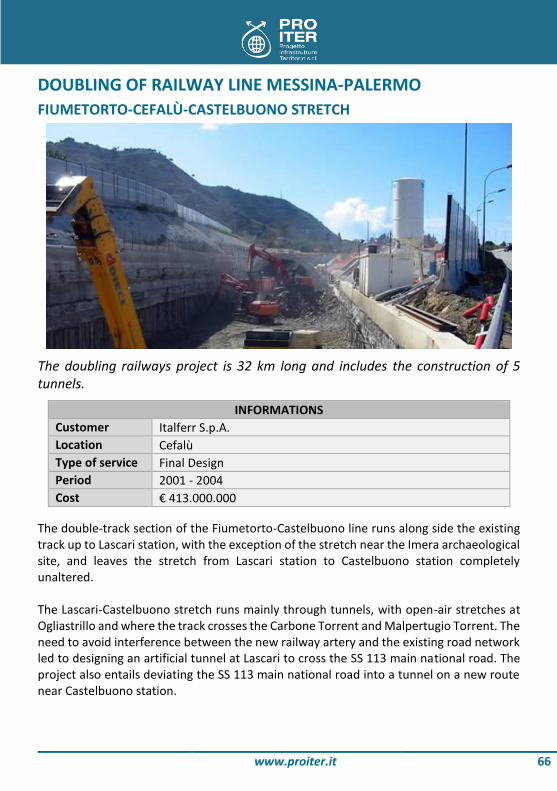
DOUBLING OF RAILWAY LINE MESSINA-PALERMO FIUMETORTO-CEFALÙ-CASTELBUONO STRETCH
The doubling railways project is 32 km long and includes the construction of 5 tunnels.
INFORMATIONS Customer Italferr S.p.A. Location Cefalù Type of service Final Design Period 2001 - 2004 Cost € 413.000.000
The double-track section of the Fiumetorto-Castelbuono line runs along side the existing track up to Lascari station, with the exception of the stretch near the Imera archaeological site, and leaves the stretch from Lascari station to Castelbuono station completely unaltered. The Lascari-Castelbuono stretch runs mainly through tunnels, with open-air stretches at Ogliastrillo and where the track crosses the Carbone Torrent and Malpertugio Torrent. The need to avoid interference between the new railway artery and the existing road network led to designing an artificial tunnel at Lascari to cross the SS 113 main national road. The project also entails deviating the SS 113 main national road into a tunnel on a new route near Castelbuono station.

www.proiter.it 67
Track-doubling also led to transforming Lascari and Cefalù stations into underground stops. Cefalù station is particularly interesting since it is entirely built in a bored tunnel, by widening the existing line tunnel. A special system of tunnels, duly equipped with stairs, ramps, lifts and the technological installations required to ensure rail service users safety and comfort inks with the outside. The station entrance-exit comes out onto the suitably equipped current station square.
MAIN FEATURES OF WORK Total length: 17 km Tunnels: 5 Total length of natural tunnels: 15.5 km Total length of Cefalù station: 420 meters Maximum length of station: about 45 meters
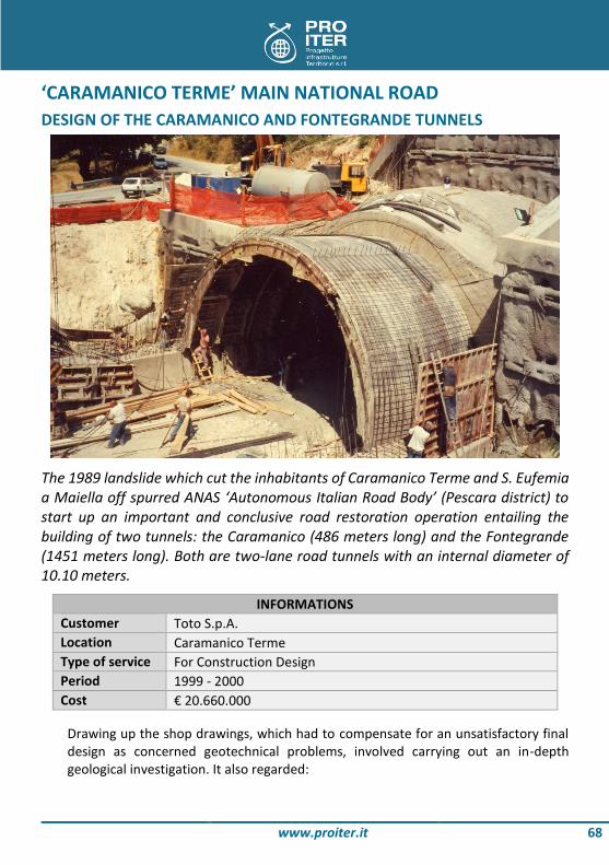
www.proiter.it 68
‘CARAMANICO TERME’ MAIN NATIONAL ROAD DESIGN OF THE CARAMANICO AND FONTEGRANDE TUNNELS
The 1989 landslide which cut the inhabitants of Caramanico Terme and S. Eufemia a Maiella off spurred ANAS ‘Autonomous Italian Road Body’ (Pescara district) to start up an important and conclusive road restoration operation entailing the building of two tunnels: the Caramanico (486 meters long) and the Fontegrande (1451 meters long). Both are two-lane road tunnels with an internal diameter of 10.10 meters.
INFORMATIONS Customer Toto S.p.A. Location Caramanico Terme Type of service For Construction Design Period 1999 - 2000 Cost € 20.660.000
Drawing up the shop drawings, which had to compensate for an unsatisfactory final design as concerned geotechnical problems, involved carrying out an in-depth geological investigation. It also regarded:

www.proiter.it 69
- determining the static and technological dimensions of the natural tunnels to be dug with traditional mechanical means through detrital covering material from gravitational sliding (maximum ground cover of 70 meters - Fontegrande and 40 meters - Caramanico);
- the building of the Caramanico tunnel in particular which involved passing under the town of the same name, with very little ground cover in some places; this unavoidably led to problems with the foundations of buildings along the path, which were brilliantly solved during the work;
- the static design of the mouths and artificial tunnels. Careful and accurate monitoring measurements were carried out during all building stages, which also allowed the most critical steps to be kept under control. Today both tunnels have been successfully completed without damaging either buildings or structures.
MAIN FEATURES OF THE DESIGNED TUNNELS ‘Caramanico’ tunnel: 486 meters long ‘Fontegrande’ tunnel: 1451 meters long Natural tunnels with traditional excavation Internal diameter: 10.10 meters Monitoring during construction phase

www.proiter.it 70
ALTERNATIVE ROUTE ON S.P.3 DESIGN OF TWO TWO-LANE ROAD TUNNELS ON MAIN PROVINCIAL ROAD OF VAL SENALES
The need to keep users of the SP 3 main provincial road through the Val Senales safe from the danger of falling rocks of various sizes led the provincial government to design an alternative route for the aforementioned road.
INFORMATIONS Customer Studio Dr. Ing. Fischer (Merano) Location Naturno Type of service Detailed Design; Works Management Period 1998 - 2002 Cost € 14.000.000
On account of the alpine valley landscape, the bypass mainly passes underground, through two tunnels. From the design point of view, the fact the tunnels are placed in the rock wall meant carrying out a precise study of the stresses in the rocks in order to assess the ratio between the main stresses at the foot of the slope and estimate the degree of breakage of the rock affected by excavation. Owing to the facts mentioned above, the final design involved in-depth geomechanical investigations and analyses of the behavior of the rocks in the conditions before and after the works were carried out. It also involved:

www.proiter.it 71
- establishing the static and technological dimensions of the natural tunnels to be dug through metamorphic rocks under a maximum ground cover of 120 m using traditional excavation methods;
- the static design of the artificial approach tunnels to the underground structures, which also involved works to make both the slope and road safe.
MAIN FEATURES OF WORK Tunnel 1, 800 meters long Tunnel 2, 330 meters long Natural tunnels dug out of the rock Plate walls with tie-rods for upstream opening of the tunnel 2
www.proiter.it 72
PRO ITER S.r.l . Via G.B. Sammartini , 5
20125 Milano IT Tel. +39 02 6787911
Fax +39 02 87152612 [email protected] www.proiter.it

PRO ITER s.r.l.Via G.B. Sammartini, 5 - 20125 MILANO (IT)Tel. +39 02 6787911Email [email protected]. [email protected] 12688370159
Antera Group
Pro Iter s.r.l., operating since 1998, is one of the �rst Italian engineering companies completely indipendent in the �eld of infrastructural design and works management.
Thanks to its expertise achieved over the years, Pro Iter s.rl. is able to comply with its customers’ requires in all the �elds of integrated enginee-ring services, by guaranteeing a high-quality, �exible, e�cient and punctual consultancy service.
www.proiter.it
Member of
Società Italiana GallerieItalian Tunneling Society


![arXiv:1705.08041v2 [cs.CV] 18 Dec 2018 · iter iter iter iter Single Iteration: CNN Prior Figure 1: A proximal gradient ODP network for deblurring under Gaussian noise, mapping the](https://static.fdocuments.in/doc/165x107/5f39be22f6fe290b831f0c4a/arxiv170508041v2-cscv-18-dec-2018-iter-iter-iter-iter-single-iteration-cnn.jpg)