GlobalComServer A MODULAR AND POWERFUL CONCEPT … Unified messaging server.
Minten 41
The Modular System Concept of IGI
HUBERT MINTEN, Kreuztal
ABSTRACT Over the last 15 years IGI expanded its product range from a pure navigation and sensor management (CCNS) solution to a set of products that can be combined to complete aerial survey systems. The integrated sensors include products that are provided by IGI, such as the LiteMapper, the DigiCAM and the DigiTHERM and a number of sensors from other providers like most of the contemporary large format digital and analog cameras. The main emphasis was always given to a deep integration of the different components to provide a save and efficient work flow. Additionally, an optimal flexibility to adapt to different conditions - like different aircraft or sensor combinations - was aspired. With the new Sensor Management Units (SMUs), IGI reaches the next step of integration and flexibility.
1. INTRODUCTION
A survey aircraft including its crew and operational sensor equipment is an expensive asset. The high investment - together with the very specific weather, light and seasonal conditions that have to be fulfilled in order to create a good survey product - creates a strong pressure to the survey company to optimize the usage rate of the expensive crew and equipment and demands an increase of efficiency. With the modular design of its systems and components, IGI provides tools that improve the flexibility of the user, allowing him to adapt his equipment to different survey tasks and assisting him in reaching better efficiency rates. This modular design enables the combination of single sensors to sensor bundles - such as Multi-DigiCAMs - to enhance the coverage of each image. Sensors of different types can be combined to multi sensor systems, like LIDAR plus digital camera, LIDAR plus thermal infrared (ThIR) camera or LIDAR with both, DigiCAM and DigiTHERM. Beyond that, the interoperability allows to use the common components of the survey systems for different sensor installations. For example, the same aircraft, sensor navigation system, GNSS/IMU system, stabilized mount and camera control computer with storage can be used for a photoflight in the day and for a ThIR flight in the night.
2. A MODULAR SYSTEM CONCEPT
IGIs modular system concept allows the customer to start with the investment of basic components and to add components/modules to his assets whenever the market, special projects, new developments or other requirements demand them. The modularity is shown with the four product groups in the IGI portfolio:
Mission planning Flight guidance and sensor management Precise position and attitude determination Aerial sensors
Photogrammetric Week '09 Dieter Fritsch (Ed.) Wichmann Verlag, Heidelberg, 2009

42 Minten
Along with its own products, IGI provides the integration of third party sensors and offers special adaptations and developments on customer request. This paper gives an overview about the new system components that IGI announces in 2009: IGIplan, DigiTHERM, SMU, IMU-IIe and Multi Sensor Systems.
2.1. Mission Planning
IGIplan is IGI's new mission planning software. It offers an intuitive interactive planning of flight missions. By setting mission parameters such as GSD, forward overlap, side ward overlap or area to be covered, IGIplan automatically creates flight lines with photo positions that fulfill the given settings.
The software provides sensor support for digital cameras, analog cameras, LIDAR, line scanners and sensor combinations like a LiteMapper together with a DigiCAM. The user can define sensors of these types and add them to the sensor database. To control the generated mission, the effect of the mission parameters is simulated in IGIplan. Flight lines along with the exposures are shown in a graphical view. The coverages of the sensor can be shown individually or accumulated. Areas with double or triple overlap can be indicated. To check the right positions of the flightlines and exposures, raster maps (tiff, png, jpg, ...)
and vector maps (dxf, shp, dgn, ...) can be added to the view. Automatic web access to satellite images (world wide) and OpenStreetMap (Europe wide) is built into IGIplan. Downloading a referenced background map for a target area is done within seconds. Exporting flight lines, exposures and simulated values can be done in an ASCII tabular format as well as in graphical formats: KML-Format, shape-format, dxf-format, georeferenced raster maps.
Fig. 1: Track Propose: Automatic generation of exposures to cover a track (here a river including riversides).
Minten 43
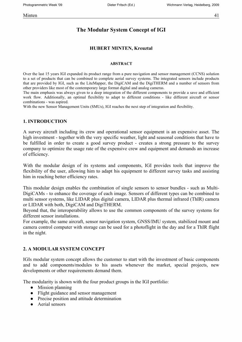
IGIplan has strong Digital Terrain Model (DTM) support. Retrieving a DTM is easy using the built-in web access. Currently supported data-sets are SRTM (about 90m resolution) and GTOP30 (about 1km). Other raster DTM data can be imported manually. Taking the DTM into account, the generation of flight lines and exposures can adapt the ground level, distance of events and flight lines dynamically. Generation of separate flight levels is possible, too. Coverages are formed using the DTM. Statistical informa-tion (min/max/mean) about GSD, dots/m², overlap, GL, AGL are shown in the reports.
2.2. Sensor Management Units (SMUs)
To be able to have all modular components running in one computer environment, IGI decided to develop its new computer product line, the Sensor Management Units (SMUs).
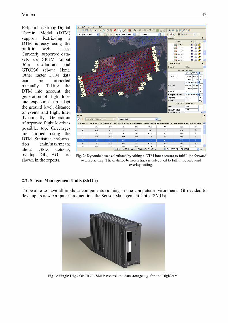
Fig. 3: Single DigiCONTROL SMU: control and data storage e.g. for one DigiCAM.
Fig. 2: Dynamic bases calculated by taking a DTM into account to fulfill the forward overlap setting. The distance between lines is calculated to fulfill the sideward
overlap setting.
44 Minten
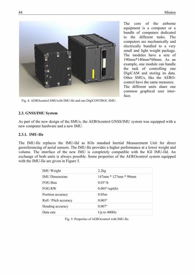
The core of the airborne equipment is a computer or a bundle of computers dedicated to the different tasks. The computers are mechanically and electrically bundled to a very small and light weight package. The modules have a size of 190mm*140mm*60mm. As an example, one module can handle the task of controlling one DigiCAM and storing its data. Other SMUs, like the AERO-control have the same measures. The different units share one common graphical user inter-face.
2.3. GNSS/IMU System
As part of the new design of the SMUs, the AEROcontrol GNSS/IMU system was equipped with a new computer hardware and a new IMU.
2.3.1. IMU-IIe
The IMU-IIe replaces the IMU-IId as IGIs standard Inertial Measurement Unit for direct georeferencing of aerial sensors. The IMU-IIe provides a higher performance at a lower weight and volume. The interface of the new IMU is completely compatible with the IGI IMU-IId. An exchange of both units is always possible. Some properties of the AEROcontrol system equipped with the IMU-IIe are given in Figure 5.
IMU Weight 2.2kg
IMU Dimensions 147mm * 127mm * 98mm
FOG Bias 0.03°/h
FOG RW 0.005°/sqrt(h)
Position accuracy 0.05m
Roll / Pitch accuracy 0.003°
Heading accuracy 0.007°
Data rate Up to 400Hz
Fig. 5: Properties of AEROcontrol with IMU-IIe.
Fig. 4: AEROcontrol SMUwith IMU-IIe and one DigiCONTROL SMU.
Minten 45
2.3.2. AEROcontrol SMU
The new AEROcontrol SMU is shown together with the IMU-IIe in Figure 4. Besides the deeper integration to the other system components via the SMU concept, the new hardware and software of the AEROcontrol enables the realization of multisensor systems with the need of highly precise timestamps for a large number of sensors. Furthermore, the capabilities to control stabilized sensor mounts were improved. The new AEROcontrol has additional interfaces that simplify the implementation of single piece systems for special applications.
2.4. Sensor Systems
Besides the support of third party sensors, such as the Vexcel Imaging UltraCam oder the Z/I Imaging DMC, IGI offers a series of aerial sensors that can be operated either as standalone sensors, or as a part of multi sensor systems.
2.4.1. DigiCAM
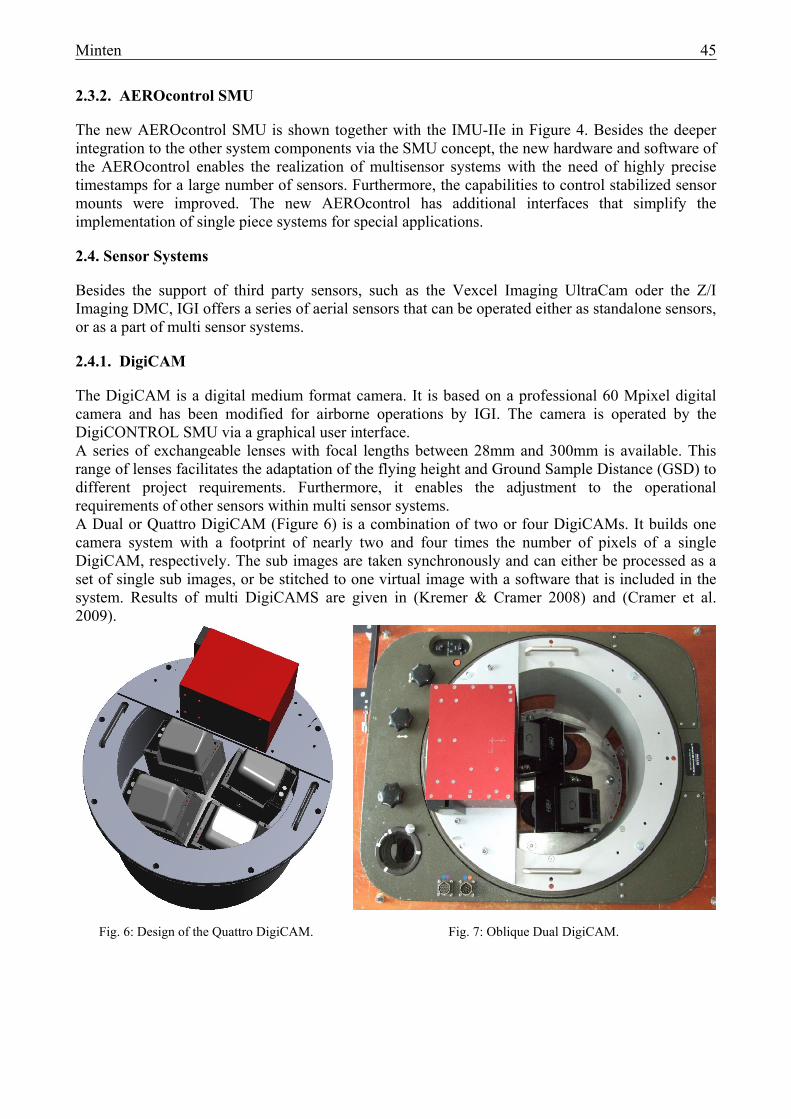
The DigiCAM is a digital medium format camera. It is based on a professional 60 Mpixel digital camera and has been modified for airborne operations by IGI. The camera is operated by the DigiCONTROL SMU via a graphical user interface. A series of exchangeable lenses with focal lengths between 28mm and 300mm is available. This range of lenses facilitates the adaptation of the flying height and Ground Sample Distance (GSD) to different project requirements. Furthermore, it enables the adjustment to the operational requirements of other sensors within multi sensor systems. A Dual or Quattro DigiCAM (Figure 6) is a combination of two or four DigiCAMs. It builds one camera system with a footprint of nearly two and four times the number of pixels of a single DigiCAM, respectively. The sub images are taken synchronously and can either be processed as a set of single sub images, or be stitched to one virtual image with a software that is included in the system. Results of multi DigiCAMS are given in (Kremer & Cramer 2008) and (Cramer et al. 2009).
Fig. 6: Design of the Quattro DigiCAM. Fig. 7: Oblique Dual DigiCAM.
46 Minten
For the efficient recording of oblique images, the DigiCAMs can be mounted in oblique angles according to customers specifications. Figure 7 shows an oblique Dual DigiCAM with an oblique angle of 45°.
2.4.2. LiteMapper
The LiteMapper combines a wide-angle, full waveform digitizing LIDAR with a medium-format digital frame camera. With its laser pulse rate of up to 240kHz and its maximum range of 3000m it is a perfect tool for corridor mapping as well as area mapping. The full waveform digitization feature enables the user to extract the most comprehensive vertical information from the acquired echo signals. The system can be operated in fixed-wing aircraft or in helicopters.
2.4.3. DigiTHERM
The DigiTHERM is a Thermal Infrared (ThIR) camera with an uncooled 640*480 pixel micro-bolometer array. Details about the DigiTHERM are given in (Kremer 09).
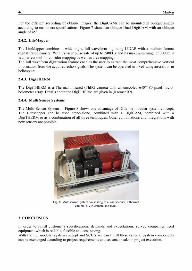
2.4.4. Multi Sensor Systems
The Multi Sensor System in Figure 8 shows one advantage of IGI's the modular system concept. The LiteMapper can be used stand-alone, combined with a DigiCAM, combined with a DigiTHERM or as a combination of all three techniques. Other combinations and integrations with new sensors are possible.
3. CONCLUSION
In order to fulfill customer's specifications, demands and expectations, survey companies need equipment which is reliable, flexible and cost-saving. With the IGI modular system concept and SCU’s we can fulfill these criteria. System components can be exchanged according to project requirements and seasonal peaks in project execution.
Fig. 8: Multisensor System constisting of a laserscanner, a thermal camera, a VIS camera and IMU.

Minten 47
4. REFERENCES
Cramer, M., Krauβ, H., Jacobsen, K., von Schönermark, M., Haala, N. & Spreckels, V. (2009): Das DGPF-Projekt zur Evaluierung digitaler photogrammetrischer Kamerasysteme. Tagungsband 18/2009, Jahrestagung DGPF Jena, 2009.
Kremer, J. (2009): Optimized Data Acquisition with the IGI DigiTHERM Thermal Camera System, Photogrammetric Week '09, this Book.
Kremer, J. & Cramer, M. (2008): Results of a Performance Test of a Dual Mid-Format Digital Camera System. The International Archives of the Photogrammetry, Remote Sensing and Spatial Information Sciences, Vol. XXXVII, Part B1, Commission 1. ISPRS Congress 2008, Beijing, China. P. 1051ff. ISSN 1682-1750.