A pilot scale integrated seaweed (Ulva lactuca) & abalone (Haliotis midae) recirculation system

The Effect of Sea Lettuce (Ulva lactuca) Mats on Sediment Quality
in Three Prince Edward Island Estuaries
January, 1999
Kendall R. Shaw
PEI Department of Technology and Environment
Charlottetown, PEI

i
Executive Summary
Sediment core samples were collected from Covehead, Darnley and Wilmot in Prince
Edward Island (P.E.I.) in July, August and September 1998. Core samples were analyzed
for organic matter content, redox potential, and total sulfide levels. Each sample was
categorized as ulva (under mat of Ulva lactuca) or reference (area removed from Ulva
mat in the same estuary). There were significant differences found between ulva and
reference values for organic matter, redox potential and log total sulfides. It is unknown
whether these significant differences are large enough to have an effect on benthic macro
faunal populations. Ulva and reference values from Covehead Bay were significantly
different for organic matter, redox potential and log total sulfides. In Darnley ulva and
reference values were significantly different for redox potential and total sulfides. No
significant differences between categories were seen in Wilmot. The impact of sea
lettuce mats on underlying sediments may be site specific.

ii
TABLE OF CONTENTS
EXECUTIVE SUMMARY i
TABLE OF CONTENTS ii
LIST OF FIGURES iii
LIST OF TABLES iv
INTRODUCTION 1
MATERIALS AND METHODS 2
Site Selection 2
Sample Collection 2
Core Analysis 2
Statistical Analysis 3
RESULTS 4
Sediment Profiles 4
Seasonal Trends 11
Covehead 13
Darnley 15
Wilmot 17
DISCUSSION 19
CONCLUSION 21
LITERATURE CITED 23
APPENDIX A. MAPS OF SAMPLE LOCATIONS
24
APPENDIX B.. SAMPLE DATA 29

iii
LIST OF FIGURES
Figure 1: OM values for ulva and reference samples 5 Figure 2: Core profile of Eh values for all sites combined 5 Figure 3: Core profile of S values for all sites combined 6 Figure 4: Core profile of Eh values for ulva and reference samples 6 in Covehead Bay Figure 5: Core profile of S values for ulva and reference samples 7 in Covehead Bay Figure 6: Core profile of Eh values for ulva and reference samples 7 in Darnley River Figure 7: Core profile of S values for ulva and reference samples 8 in Darnley River Figure 8: Core profile of Eh values for ulva and reference samples 8 in Wilmot River Figure 9: Core profile of S values for ulva and reference samples 9 in Wilmot River Figure 10: Mean OM values over time for ulva and reference 11
samples Figure 11: Mean Eh values over time for ulva and reference samples 12 Figure 12: Mean S values over time for ulva and reference samples 12 Figure 13: Mean OM values over time for ulva and reference 13
samples in Covehead Bay Figure 14: Mean Eh values over time for ulva and reference samples 14 in Covehead Bay Figure 15: Mean S values over time for ulva and reference samples 14 in Covehead Bay Figure 16: Mean OM values over time for ulva and reference 15
samples in Darnley River
LIST OF FIGURES (Cont./...)

iv
Figure 17: Mean Eh values over time for ulva and reference samples 16 in Darnley River Figure 18: Mean S values over time for ulva and reference samples 16 in Darnley River Figure 19: Mean OM values over time for ulva and reference 17
samples in Wilmot River Figure 20: Mean Eh values over time for ulva and reference samples 18 in Wilmot River Figure 21: Mean S values over time for ulva and reference samples 18 in Wilmot River Figure 22: Relationship between total sulfides and redox potential 21
LIST OF TABLES
Table 1: T-test means and p values for ulva and reference samples 10

1
Introduction
Heavy mats of sea lettuce (Ulva lactuca) tend to collect in upper estuary areas during the
warmest months of the year on Prince Edward Island (P.E.I.). These mats often have
diverse effects on the underlying benthos such as increased anoxia, increased organic
matter sedimentation, decreased circulation and possibly shellfish mortality. During the
spring of 1997, heavy over-winter mortalities of oysters were noted in a number of areas
of P.E.I.. The presence of black discoloration on the shells of some of these oysters could
indicate that anoxic conditions may have been a factor in these mortalities. It has been
suggested that this anoxia could have been caused by decaying algal mats, especially
Ulva sp., that could settle over the oyster beds in the relatively quiescent conditions
under winter ice.
Organic enrichment is one of the most common disturbances of marine benthic
communities (Weston 1990). Variation in the organic input to any area results in changes
in chemical, physical, and biological factors which have effects on the benthic fauna
present (Pearson and Rosenberg 1978). Consequences of the build-up of organic material
include an increase in oxygen consumption by organically enriched sediments, the
formation of anoxic sediments and the production and release of harmful gases to the
water column (Mattson and Linden 1983, Kaspar et al 1985). Most of these conditions
influence the abundance and composition of the benthic community (Schafer et al 1995).
Sulfides are produced from the decomposition of organic matter (Greenberg et al. 1992),
thus total sulfide levels are sensitive indicators of benthic organic enrichment (Hargrave
et al. 1997). A measure of the redox potential (Eh) of sediment cores serves as a guide to
the biological condition of the sediment and the degree of organic loading to which it is
subjected (Pearson and Stanley 1979). Whitfield (1969) describes Eh as a semi-
quantitative indicator of the degree of stagnation of a particular environment.
The objective of this study is to provide an indication of the extent of anoxic conditions
underlying Ulva mats in P.E.I. estuaries. Very little information concerning the effect of
sea lettuce mats on the underlying sediment is available. This study is short term and is

2
not designed to provide insight regarding a long term temporal change in sediment
quality. These results can be used as preliminary data for a more extensive survey
assessing the impact of the over-wintering sea lettuce mats on the benthos and shellfish
growing conditions.
Materials and Methods
Site Selection
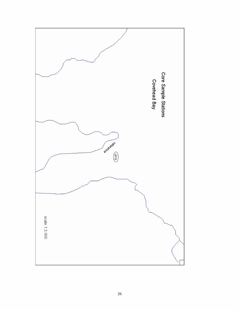
Sample sites were selected in estuaries where an area exposed to a mat of sea lettuce was
adjacent to an area which was relatively clear of sea lettuce. Three sample sites
(estuaries) were selected: Covehead, Darnley and Wilmot. Maps of sample locations are
included in Appendix A. These maps were created using MapInfo.
Sample Collection
Sediment core samples for chemical analysis were collected between July 8, 1998 and
September 15, 1998. Each site was sampled approximately once a week. Duplicate
samples (2 cores) were taken under both the Ulva mat and corresponding reference
location. Reference sample locations were chosen as areas unexposed to sea lettuce
which were in a similar location, and water depth as the corresponding ulva sample.
Samples were taken on foot. Core liners were constructed from PVC tubing in 30 cm
lengths. The liners had holes drilled every 2 cm and were wrapped in duct tape to prevent
water and sediment loss. The core liners were simply inserted into the sediment. Core
catchers were used to retain the sediment while the samples were removed from the
substrate. Upon retrieval, the cores were capped with plastic caps, labeled, kept upright
and transported to the lab.
Core Analysis
All core samples were analyzed within 24 hours of collection, however most were
analyzed immediately upon return to lab. If necessary, samples were refrigerated

3
overnight. Each sample was analyzed for the following three variables: organic matter
content (OM), redox potential (Eh), and total sulfide concentration (S).
Organic matter content was only determined in the surficial sediment layer of each core.
Five ml of sediment were extracted from the surface layer (i.e. the top hole of the core
liner that had underlying sediment) with a 5 ml cut-off syringe The sediment was placed
in a pre-weighed crucible which was put in an Isotemp Incubator; Model 225D, at 60oC
for 48 hours and then weighed to determine sediment dry weight. Finally crucibles were
placed in an Isotemp Muffle Furnace; Model 186A, at 600oC for one hour and weighed to
determine organic matter content expressed as a percentage of sediment dry weight.
S and Eh were measured along the length of the sediment core. For S, measurement, five
ml of sediment were extracted, from the second hole with underlying sediment, with a
cut-off syringe. This was repeated at every fourth hole (every 8 cm). Sediment from each
hole was inserted into a separate 30 ml plastic vial. S concentration was measured with
an Orion 9616BN Combination Silver/Sulfide Electrode. Electrode calibration and
sulfide measurements were performed as described in Hargrave et al. (1995).
Eh was measured at each core liner hole that had underlying sediment using an Orion
9678BN Combination Redox Electrode. Electrode calibration and Eh measurement were
done as described in Hargrave et al. (1995).
Statistical Analysis
All statistical analysis was done using Systat 7. There are two data sets both of which are
assigned a category name:
Name Description
Ulva Samples taken under sea lettuce mat
Reference Samples taken from reference area adjacent to sea lettuce mat

4
OM, Eh, and S values for core profiles are found in Appendix B. The data sets were
arranged so that each ulva core sample is paired with its corresponding reference core
sample. Samples are also paired by sediment depth,
Variable values from the 2 sample categories were compared for all sites combined using
a paired t-test. S data was log transformed for all t-tests. A p-value < 0.05 was considered
to indicate a significant statistical difference. This was also done for each sample site
individually.
Core profiles of Eh and S were created by running a LOWESS smoother line through
scatter plots and deleting plot symbols. Due to high range of S values in Covehead, the x-
axis in Figures 3 and 5 and the y-axis in Figures 12 and 15 are in log format.
Results
Sediment Profiles
When results from all three estuaries were combined, the ulva samples had significantly
higher OM (Figure 1) and LogS (Figure 3) than the reference samples, while Eh was
significantly lower (Figure 2)(Table 1). Similar significant differences were seen for the
Covehead site individually (Table 1). Differences between ulva and reference Eh
(Figure 4) and S (Figure 5) values were consistent throughout the length of the cores in
Covehead.
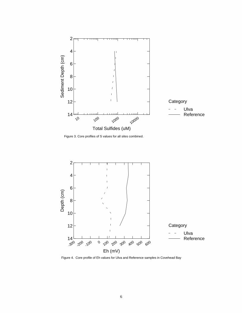
In Darnley, ulva values were significantly higher for S (Figure 5) and significantly lower
for Eh (Figure 6) than reference locations, while OM values (Figure 1) were not
significantly different (Table 1). No significant differences were found between ulva and
reference locations in Wilmot. for OM (Figure 1), S (Figure 7) and Eh (Figure 8, Table
1).

5
CoveheadDarnley
Wilmot
SITE
0
1
2
3
4
5
6
7
8
Org
anic
Mat
ter (
%)
REFERENCEULVA
Category
Ulva
Reference
Figure 1. Mean OM values for ulva and reference samples.
2
4
6
8
10
12
14
Sed
imen
t Dep
th (c
m)
-600 -400 -200 0 200 400 600 800Redox Potential (mV)
ReferenceUlva
Category
Figure 2. Core profile of Eh values for all sites combined.
6
2
4
6
8
10
12
14
Sed
imen
t Dep
th (c
m)
10 1001000
10000
Total Sulfides (uM)
ReferenceUlva
Category
Figure 3. Core profiles of S values for all sites combined.
2
4
6
8
10
12
14
Dep
th (c
m)
-300-200
-100 0 100 200 300 400 500 600
Eh (mV)
ReferenceUlva
Category
Figure 4. Core profile of Eh values for Ulva and Reference samples in Covehead Bay
7
2
4
6
8
10
12
14
Dep
th (c
m)
10 1001000
10000
Total Sulfides (uM)
ReferenceUlva
Category
Figure 5. Core profile of S values for Ulva and Reference samples in Covehead Bay
2
4
6
8
10
12
14
Dep
th (c
m)
-200-100 0 100 200 300 400 500 600 700
Eh (mV)
ReferenceUlva
Category
Figure 6. Core profile of Eh values for Ulva and Reference samples in Darnley River

8
2
4
6
8
10
12
14
Dep
th (c
m)
0 1000 2000 3000 4000Total Sulfides (uM)
ReferenceUlva
Category
Figure 7. Core profile of S values for Ulva and Reference samples in Darnley River
2
4
6
8
10
12
14
Dep
th (c
m)
-500-400
-300-200
-100 0 100 200 300 400
Eh (mV)
ReferenceUlva
Category
Figure 8. Core profile of Eh values for Ulva and Reference samples in Wilmot River

9
2
4
6
8
10
12
14
Dep
th (c
m)
0 1000 2000 3000Total Sulfides (uM)
ReferenceUlva
Category
Figure 9. Core profile of S values for Ulva and Reference samples in Wilmot River

10
Table 1. T-test mean and p values for Ulva and Reference samples ________________________________________________________________________ t-test mean Site Variable Ulva Reference p value ________________________________________________________________________ Total Organic Matter (%) 2.32 1.59 0.010* Total Sulfides (FM) 2158 1144 0.107 LogTotal Sulfides (FM) 3.01 2.80 0.021* Redox Potential (mV) 150 265 0.000* Covehead Organic Matter (%) 2.71 1.15 0.008* Total Sulfides (FM) 3374 1097 0.174 LogTotal Sulfides (FM) 3.07 2.61 0.049* Redox Potential (mV) 73 320 0.000* Darnley Organic Matter (%) 1.82 1.70 0.661 Total Sulfides (FM) 1550 1117 0.046* LogTotal Sulfides (FM) 3.01 2.89 0.058 Redox Potential (mV) 237 282 0.005* Wilmot Organic Matter (%) 2.35 2.25 0.759 Total Sulfides (FM) 1015 1260 0.372 LogTotal Sulfides (FM) 2.89 2.96 0.467 Redox Potential (mV) 71 45 0.676 ________________________________________________________________________ * indicates significant difference
The July 09 Ulva sample in Covehead is an outlier and may be skewing t-test results
When performing the t-test without this outlier, no significant difference was seen
between ulva and reference samples for LogS (p value 0.065) for all sites combined.
There was also no significant difference is seen between ulva and reference LogS
values (p value 0.166) for the Covehead site.

11
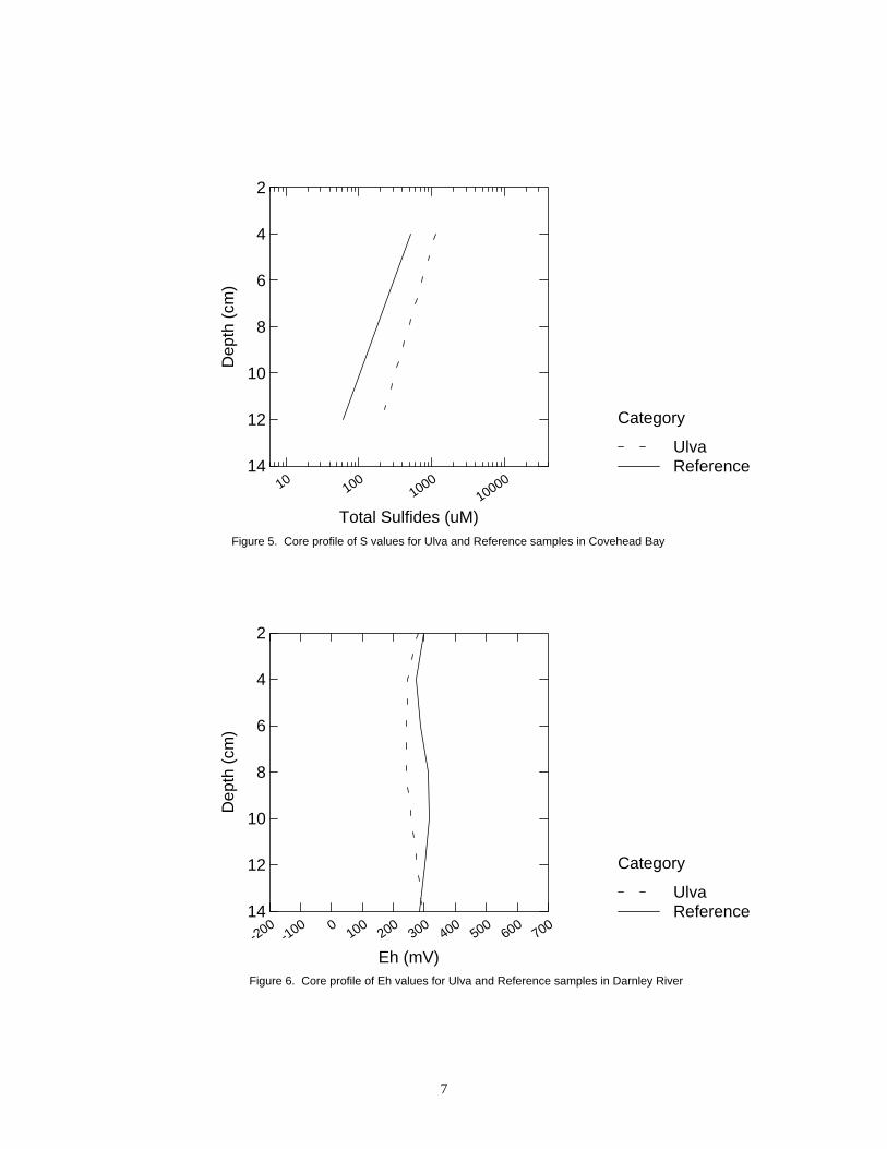
Seasonal Trends
The seasonal trends in OM, Eh and S for all sites combined, are shown in Figures 10-12
Reference samples had consistently lower OM values than ulva samples with the
exception of two sampling dates in July (Figure 10). Ulva Eh values were generally
lower than reference Eh values until late August (Figure 11), while the two categories
produced consistently similar S results with the exception of a large dichotomy on the
first sampling date (Figure 12).
7 8 9 10Time (month)
0
1
2
3
4
5
6
7
8
OM
(%)
ReferenceUlva
Category
Figure 10. Mean OM values over time for Ulva and Reference samples
12
7 8 9 10Time (month)
-600
-400
-200
0
200
400
600
800E
h (m
V)
ReferenceUlva
Category
Figure 11. Mean Eh values over time for Ulva and Reference samples
7 8 9 10Time (month)
10
100
1000
10000
Tota
l Sul
fides
(uM
)
ReferenceUlva
Category
Figure 12. Mean S values over time for Ulva and Reference samples

13
Covehead
In Covehead, reference samples yielded lower OM values than ulva samples throughout
the sampling period (Figure 13). The difference between the two categories was quite
large in July and became less distinct in August and September (Figure 13). With the
exception of two sampling dates, ulva Eh values were consistently lower than reference
Eh values throughout the sampling period (Figure 14). Throughout July, reference S
values were lower than ulva S values with the exception of one sampling date (Figure
15). In August and September, reference S values slightly exceeded their corresponding
ulva S values (Figure 15).
7 8 9 10Time (month)
0
1
2
3
4
5
6
7
8
OM
(%)
ReferenceUlva
Category
Figure 13. Mean OM values over time for Ulva and Reference samples in Covehead Bay

14
7 8 9 10Time (month)
-300
-200
-100
0
100
200
300
400
500
600E
h (m
V)
ReferenceUlva
Category
Figure 14. Mean Eh values over time for Ulva and Reference samples in Covehead Bay
7 8 9 10Time (month)
10
100
1000
10000
Tota
l Sul
fides
(uM
)
ReferenceUlva
Category
Figure 15. Mean S values over time for Ulva and Reference samples in Covehead Bay
15
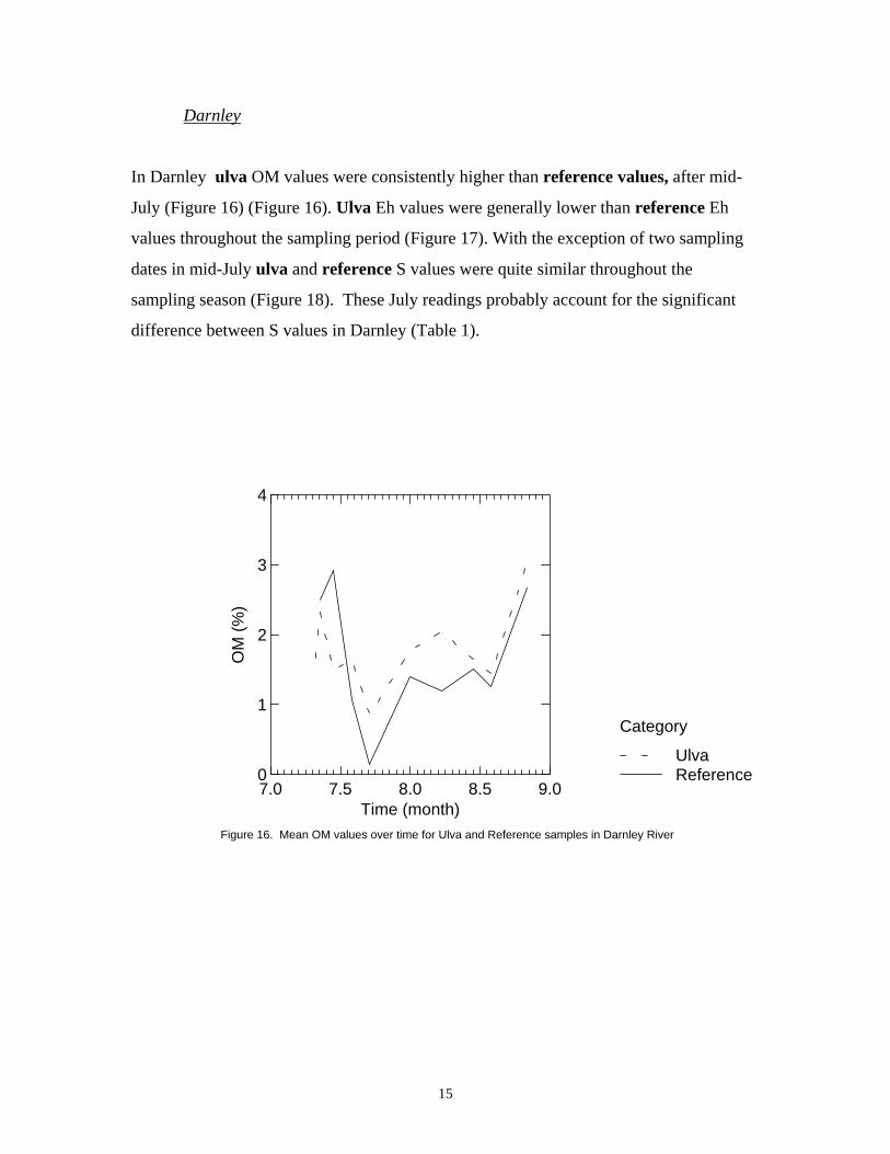
Darnley
In Darnley ulva OM values were consistently higher than reference values, after mid-
July (Figure 16) (Figure 16). Ulva Eh values were generally lower than reference Eh
values throughout the sampling period (Figure 17). With the exception of two sampling
dates in mid-July ulva and reference S values were quite similar throughout the
sampling season (Figure 18). These July readings probably account for the significant
difference between S values in Darnley (Table 1).
7.0 7.5 8.0 8.5 9.0Time (month)
0
1
2
3
4
OM
(%)
ReferenceUlva
Category
Figure 16. Mean OM values over time for Ulva and Reference samples in Darnley River

16
7.0 7.5 8.0 8.5 9.0Time (month)
-200
-100
0
100
200
300
400
500
600
700E
h (m
V)
ReferenceUlva
Category
Figure 17. Mean Eh values over time for Ulva and Reference samples in Darnley River
7.0 7.5 8.0 8.5 9.0Time (month)
0
1000
2000
3000
4000
Tota
l Sul
fides
(uM
)
ReferenceUlva
Category
Figure 18. Mean S values over time for Ulva and Reference samples in Darnley River

17
Wilmot
In Wilmot, ulva OM values were consistently higher than reference OM values after late
July (Figure 19). Ulva Eh values were lower than reference Eh values throughout the
middle of the sampling period but were higher at the beginning and end of sampling
(Figure 21). Reference S values were higher than ulva S values until mid August, after
which time they were similar (Figure 21).
7.5 8.0 8.5 9.0Time (month)
1
2
3
4
5
OM
(%)
ReferenceUlva
Category
Figure 19. Mean OM values for Ulva and Reference samples in Wilmot River

18
7.5 8.0 8.5 9.0Time (month)
-500
-400
-300
-200
-100
0
100
200
300
400E
h (m
V)
ReferenceUlva
Category
Figure 20. Mean Eh values over time for Ulva and Reference samples in Wilmot River
7.5 8.0 8.5 9.0Time (month)
0
1000
2000
3000
Tota
l Sul
fides
(uM
)
ReferenceUlva
Category
Figure 21. Mean S values over time for Ulva and Reference samples in Wilmot River

19
Discussion
Results from the three estuaries combined suggest that there is a difference in sediment
quality between areas exposed to sea lettuce mats and reference areas.
High organic matter content causes a rapid depletion of oxygen and permits the
development of anoxic environments (Bartlett 1973). Although the ulva OM levels were
significantly higher than reference OM levels in this investigation, neither category
produced high OM means (ulva 2.2%, reference 1.6%). These values are lower than
those found on the Swedish west coast (Mattson and Linden 1983, Dahlback and
Gunnarsson 1981) in coastal Maritime Canada (Schafer et al 1995) and in other P.E.I.
estuaries (Shaw 1998).
Samples taken from areas exposed to sea lettuce mats yielded significantly lower Eh
values than reference samples without algal mats. Sediment grain size may be an
important factor in this difference in Eh values as sandy sediment tends to be more
aerobic than muddy sediment and therefore has higher Eh values. Grain size was not
measured in this study.
There is a large variance in S values determined in this study (2.5x10⁷ ), which accounts
for the lack of significant difference in this parameter. Logging the values decreased this
variance (0.368) and a significant difference was found in Log S values. The samples
taken on July 09 had abnormally high S values which are outliers from the remaining
data. There is no significant difference between ulva and reference Log S or S when
these outliers were not included in the t-test.
It is unknown whether the significant statistical differences in OM, Eh and LogS are
substantial enough to impact benthic communities.
The extent of the impact of sea lettuce mats on the underlying sediment seems to be site
specific and may be related to the thickness of the sea lettuce mat to which the sampling

20
area is exposed. Of the three estuaries surveyed, Covehead seems to be the most
impacted by sea lettuce mats. Covehead ulva samples were taken under a thick Ulva mat.
It should be noted however that a rain and wind storm on August 10 washed all of the
sea lettuce ashore. In Darnley, ulva samples were taken under a dense mat of sea lettuce
that was not as thick as the mat in Covehead but which did not move during sampling.
The mat in Wilmot was quite shallow and not as thick as the other two but it also was
consistently in the same position. The difference in t-test means for the parameters in
Wilmot is not large, indicating smaller impacts.
Hargrave et al. (1997) used the relationship between S and Eh (Figure 22) to quantify
benthic enrichment zones. Zones 0 to 3 represent anoxic (grossly polluted), hypoxic
(polluted), oxic (transitory), and normal, respectively. The majority of the samples from
this study fall into the hypoxic zone with some in the anoxic zone (Figure 22). Both ulva
and reference samples are represented in all four enrichment zones but the majority of
the samples falling in the anoxic zone are ulva.
In an effort to sample areas under Ulva mats which were similar to reference areas,
samples were not taken in the deepest areas due to variation in water depth and sediment
type between locations. The deepest areas are subject to the thickest ulva mats and
underlying sediment may be more impacted than sediment under ulva mats in shallower
waters. As a result the ulva samples taken for this study are not likely representative of
the most impacted sediment conditions. It is suggested that for any similar future studies,
sediment samples be taken from three areas: areas unexposed to sea lettuce, areas
exposed to sea lettuce with similar depth and sediment type as reference areas, areas
exposed to the thickest sea lettuce mats. All sampling areas should be in similar estuary
locations.

21
10 1001000
10000
Total Sulfides (uM)
-600
-400
-200
0
200
400
600
800E
h (m
V)
R
R
U UUUU
RR
U
U
RR
UU
U
UU
UR
RRR
U U
R RU U
U
RR
RR
R
R
R
R
UU
RRU
URR
U
U
RR
UU
R
R
R
R
U
UUU
R
R
U
U
U
R
R
R R
R
R
U
U
U
R
R
UU
U
U
RR
U
U
U
UR
U U
R
UUR
U U
R
UU
U
U
U
R
RU
U
U
U
R
R
0123
Figure 22. Relationship between total sulfides and redox potential
This is a short term study designed to provide an indication of sediment health in areas
exposed to ulva growth and senescence. It does not predict long-term effects or assess
temporal change. Long term effects of a sea lettuce mat at a specific location would
depend on the mat being consistently present.
Conclusion
The combined results of the three estuaries surveyed indicate that there is a difference in
sediment quality between areas exposed to sea lettuce mats and unexposed reference
areas. These differences are not found in every estuary and their determining factors may
be site specific. Such factors may include water depth, sediment grain size and thickness

22
of the sea lettuce mat. Covehead appears to be the most impacted by the presence of sea
lettuce while Darnley appears to be the least impacted. It has not been determined
whether the significant differences between the two categories are of a great enough
magnitude to have a biological impact on the benthos.
This study does not assess the long term effects of sea lettuce mats on the underlying
sediments. In order to investigate the temporal change in sediment quality in areas
exposed to sea lettuce, a long term study would be necessary. Samples could be taken
during the winter (under ice), after the spring thaw and during late summer/early autumn.
Over a succession of sampling years, a pattern of seasonal and long term change may be
determined.
23
Literature Cited
Bartlett, G.A. 1973. Environmental analysis and sediment investigation of Georgetown harbour. Department of Regional Economic Expansion. Dahlback, B. and L.A.H. Gunnarsson. 1981. Sedimentation and sulfate reduction under a mussel culture. Mar. Biol. 63:269-275. Greenberg, A.E., L.S. Clesceri, and A.D. Eaton [ed.] 1992. Standard Methods for the Examination of Water and Wastewater, 18th ed. American Public Health Association, Washington, DC. Hargrave, B.T., G.A. Phillips, L.I. Doucette, M.J. White, T.G. Milligan, D.J. Wildish, and R.E. Cranston. 1995. Biogeochemical observations to assess benthic impacts of organic enrichment from marine aquaculture in the Western Isles region of the Bay of Fundy, 1994. Can. Tech. Rep. Fish. Aquat. Sci. 2062. Hargrave, B.T., G.A. Phillips, L.I. Doucette, M.J. White, T.G. Milligan, D.J. Wildish, and R.E. Cranston. 1997. Assessing benthic impacts of organic enrichment from marine aquaculture. Wat., Air, and Soil Poll. 99:641-650. Kaspar, H.F., P.A. Gillespie, I.C. Boyer, and A.L. MacKenzie. 1985. Effects of mussel aquaculture on the nitrogen cycle and benthic communities in Kenepuru Sound, Marlborough Sounds, New Zealand. Mar. Biol. 85:127-136. Mattson, J. and O. Linden. 1983. Benthic macrofauna succession under mussels, Mytilus edulis L. (Bivalvia) cultured on hanging long lines. Sarsia. 68:97-102. Pearson, T. and S.O. Stanley. 1979. Comparative measurement of the redox potential of marine sediments as a rapid means of assessing the effect of organic pollution. Mar. Biol. 53:371-379. Schafer, C.T., G.V. Winters, D.B. Scott, P. Pocklington, F.E. Cole, and C. Honig. 1995. Survey of living foraminifera and polychaete populations at some canadian aquaculture sites: potential for impact mapping and monitoring. J. Foram. Res. 25:236-259. Shaw, K.R. 1998. PEI Benthic Survey. Prince Edward Island Technical Report of Environmental Science No. 4. 94pp Weston, D.P. 1990. Quantitative examination of macrobenthic community changes along an organic enrichment gradient. Mar. Ecol. Prog. Ser. 61:233-244. Whitfield, M. 1969. Eh as an operational parameter in estuarine studies. Limnol. Oceanogr. 14:547-558.

24
APPENDIX A. MAPS OF SAMPLE SITES

25
26

27

28

29
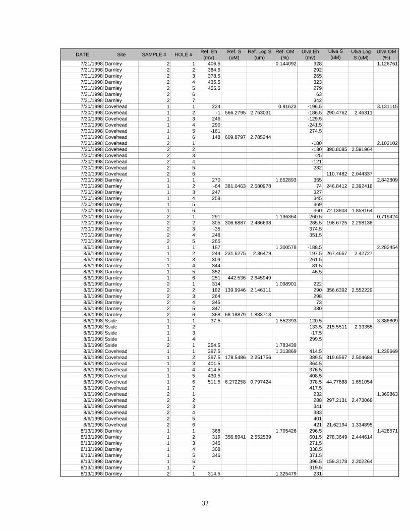
APPENDIX B. SAMPLE DATA

30
DATE Site SAMPLE # HOLE # Ref. Eh (mV)
Ref. S (uM)
Ref. Log S (um)
Ref. OM (%)
Ulva Eh (mv)
Ulva S (uM)
Ulva Log S (uM)
Ulva OM (%)
7/8/1998 Covehead 1 1 362.5 1.077586 -107 3.7647067/8/1998 Covehead 1 2 360.5 573.115 2.758242 -190 8645.959 3.9368137/8/1998 Covehead 1 3 350.5 -2127/8/1998 Covehead 1 4 377.5 -2237/8/1998 Covehead 1 5 -1297/8/1998 Covehead 1 6 -173 22902.88 4.359897/8/1998 Covehead 1 7 -2057/8/1998 Covehead 1 8 -2127/8/1998 Covehead 1 9 -1577/8/1998 Covehead 1 10 -224 32433.14 4.5109897/8/1998 Covehead 1 11 -2097/8/1998 Covehead 1 12 -2167/8/1998 Covehead 2 1 203.5 1.239669 -191.5 2.1563347/8/1998 Covehead 2 2 301.5 1000 3 -203.5 22902.88 4.359897/8/1998 Covehead 2 3 304.5 -141.57/8/1998 Covehead 2 4 59.5 -211.57/8/1998 Covehead 2 5 21.5 -204.57/8/1998 Covehead 2 6 -214.5 28219.51 4.4505497/8/1998 Covehead 2 7 -224.57/8/1998 Covehead 2 8 -227.57/8/1998 Covehead 3 1 294.5 1.238397/9/1998 Darnley 1 1 303.5 203.5 1.3966487/9/1998 Darnley 1 2 242.5 1744.851 3.241758 202.5 3263.896 3.5137367/9/1998 Darnley 1 3 270.5 207.57/9/1998 Darnley 1 4 251.5 177.57/9/1998 Darnley 2 1 241.5 265 1.9490257/9/1998 Darnley 2 2 278.5 2149.897 3.332418 262 1627.565 3.2115387/9/1998 Darnley 2 3 247.5 2287/9/1998 Darnley 2 4 182
7/10/1998 Covehead 1 1 352 2.095808 -214 3.7470737/10/1998 Covehead 1 2 346 231.9448 2.365385 -161 4021.57 3.6043967/10/1998 Covehead 1 3 335 -1887/10/1998 Covehead 1 4 336 -1967/10/1998 Covehead 1 5 325 -1637/10/1998 Covehead 2 1 334 2.03193 -187.5 5.3864177/10/1998 Covehead 2 2 370 30.83266 1.489011 -176.5 3499.097 3.5439567/10/1998 Covehead 2 3 363 -198.57/10/1998 Covehead 2 4 364 -207.57/10/1998 Darnley 1 1 209 2.491694 168 2.127667/10/1998 Darnley 1 2 267 1870.587 3.271978 128 2304.822 3.3626377/10/1998 Darnley 1 3 215 1457/10/1998 Darnley 1 4 155 1217/10/1998 Darnley 1 5 230 1617/10/1998 Darnley 1 6 232 932.7821 2.96978 186 2005.385 3.3021987/10/1998 Darnley 1 7 257 1457/10/1998 Darnley 2 1 311 201.5 2.5117747/10/1998 Darnley 2 2 271 811.5974 2.909341 164.5 2304.822 3.3626377/10/1998 Darnley 2 3 239 48.57/10/1998 Darnley 2 4 197 233.57/10/1998 Darnley 2 5 321 194.57/10/1998 Darnley 2 6 249 811.5974 2.909341 235.5 1232.138 3.0906597/10/1998 Darnley 2 7 2977/13/1998 Covehead 1 1 366 1.246537 -159 4.2606527/13/1998 Covehead 1 2 344 4021.57 3.604396 -196 932.7821 2.969787/13/1998 Covehead 1 3 268 -2107/13/1998 Covehead 1 4 327 -2007/13/1998 Covehead 1 5 -467/13/1998 Covehead 2 1 341 0.68306 -180.5 7.8431377/13/1998 Covehead 2 2 333 5695.01 3.755495 -196.5 1416.116 3.1510997/13/1998 Covehead 2 3 236 -220.57/13/1998 Covehead 2 4 222 -244.57/13/1998 Darnley 1 1 328.5 2.991453 362.5 1.2517397/13/1998 Darnley 1 2 335.5 2470.911 3.392857 348.5 1072.062 3.030227/13/1998 Darnley 1 3 294.5 313.57/13/1998 Darnley 1 4 324.5 336.57/13/1998 Darnley 1 5 302.5 339.57/13/1998 Darnley 1 6 288.5 2304.822 3.3626377/13/1998 Darnley 1 7 301.5
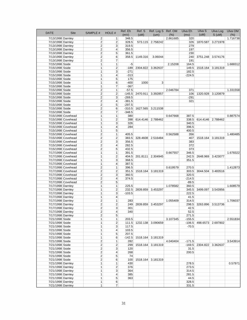
31
DATE Site SAMPLE # HOLE # Ref. Eh (mV)
Ref. S (uM)
Ref. Log S (um)
Ref. OM (%)
Ulva Eh (mv)
Ulva S (uM)
Ulva Log S (uM)
Ulva OM (%)
7/13/1998 Darnley 2 1 348.5 2.861685 320 1.7167387/13/1998 Darnley 2 2 328.5 573.115 2.758242 326 1870.587 3.2719787/13/1998 Darnley 2 3 319.5 2797/13/1998 Darnley 2 4 356.5 1977/13/1998 Darnley 2 5 361.5 2307/13/1998 Darnley 2 6 358.5 1149.316 3.06044 240 3751.248 3.5741767/13/1998 Darnley 2 7 1917/15/1998 Sside 1 1 -5 2.15208 164.5 1.6883127/15/1998 Sside 1 2 -189 2304.822 3.362637 149.5 1518.164 3.1813197/15/1998 Sside 1 3 -271 182.57/15/1998 Sside 1 4 -313 -224.57/15/1998 Sside 1 5 1757/15/1998 Sside 1 6 -400 1000 37/15/1998 Sside 1 7 -3677/15/1998 Sside 2 1 -57.5 2.046784 371 1.3315587/15/1998 Sside 2 2 -145.5 2470.911 3.392857 106 1320.928 3.1208797/15/1998 Sside 2 3 -269.5 -2917/15/1998 Sside 2 4 -381.5 3217/15/1998 Sside 2 5 -297.57/15/1998 Sside 2 6 -310.5 1627.565 3.2115387/15/1998 Sside 2 7 -348.57/15/1998 Covehead 1 1 380 0.647668 387.5 0.8875747/15/1998 Covehead 1 2 398 614.4146 2.788462 338.5 614.4146 2.7884627/15/1998 Covehead 1 3 326 340.57/15/1998 Covehead 1 4 284 396.57/15/1998 Covehead 1 5 400.57/15/1998 Covehead 2 1 405.5 0.562588 356 1.4804857/15/1998 Covehead 2 2 383.5 328.4608 2.516484 407 1518.164 3.1813197/15/1998 Covehead 2 3 356.5 3837/15/1998 Covehead 2 4 282.5 3727/15/1998 Covehead 2 5 432.5 3737/17/1998 Covehead 1 1 391.5 0.667557 346.5 1.6783227/17/1998 Covehead 1 2 404.5 201.8111 2.304945 242.5 2648.969 3.4230777/17/1998 Covehead 1 3 368.5 351.57/17/1998 Covehead 1 4 387.57/17/1998 Covehead 2 1 396.5 0.619579 270.5 1.4128737/17/1998 Covehead 2 2 351.5 1518.164 3.181319 303.5 3044.504 3.4835167/17/1998 Covehead 2 3 360.5 320.57/17/1998 Covehead 2 4 374.5 -214.57/17/1998 Covehead 2 5 -89.57/17/1998 Darnley 1 1 225.5 1.078582 360.5 1.6085797/17/1998 Darnley 1 2 232.5 2839.859 3.453297 345.5 3499.097 3.5439567/17/1998 Darnley 1 3 -103.5 222.57/17/1998 Darnley 1 4 41.57/17/1998 Darnley 2 1 283 1.055409 314.5 1.7060377/17/1998 Darnley 2 2 249 2839.859 3.453297 298.5 3263.896 3.5137367/17/1998 Darnley 2 3 301 42.57/17/1998 Darnley 2 4 340 52.57/17/1998 Darnley 2 5 271.57/21/1998 Sside 1 1 203.5 3.107345 -155.5 2.5518347/21/1998 Sside 1 2 111.5 1232.138 3.090659 -106.5 498.6573 2.6978027/21/1998 Sside 1 3 117.5 -70.57/21/1998 Sside 1 4 103.57/21/1998 Sside 1 5 207.57/21/1998 Sside 1 6 -142.5 1518.164 3.1813197/21/1998 Sside 2 1 282 4.040404 -171.5 3.5439147/21/1998 Sside 2 2 299 1518.164 3.181319 -169.5 2304.822 3.3626377/21/1998 Sside 2 3 120 31.57/21/1998 Sside 2 4 268 200.57/21/1998 Sside 2 5 747/21/1998 Sside 2 6 100 1518.164 3.1813197/21/1998 Darnley 1 1 430 278.5 0.579717/21/1998 Darnley 1 2 376 273.57/21/1998 Darnley 1 3 364 314.57/21/1998 Darnley 1 4 385 281.57/21/1998 Darnley 1 5 363 44.57/21/1998 Darnley 1 6 328.57/21/1998 Darnley 1 7 331.5
32
DATE Site SAMPLE # HOLE # Ref. Eh (mV)
Ref. S (uM)
Ref. Log S (um)
Ref. OM (%)
Ulva Eh (mv)
Ulva S (uM)
Ulva Log S (uM)
Ulva OM (%)
7/21/1998 Darnley 2 1 406.5 0.144092 328 1.1267617/21/1998 Darnley 2 2 384.5 2927/21/1998 Darnley 2 3 378.5 2657/21/1998 Darnley 2 4 435.5 3237/21/1998 Darnley 2 5 455.5 2797/21/1998 Darnley 2 6 637/21/1998 Darnley 2 7 3427/30/1998 Covehead 1 1 224 0.91623 -196.5 3.1311157/30/1998 Covehead 1 2 -1 566.2795 2.753031 -186.5 290.4762 2.463117/30/1998 Covehead 1 3 246 -129.57/30/1998 Covehead 1 4 290 -241.57/30/1998 Covehead 1 5 -161 274.57/30/1998 Covehead 1 6 148 609.8797 2.7852447/30/1998 Covehead 2 1 -180 2.1021027/30/1998 Covehead 2 2 -130 390.8085 2.5919647/30/1998 Covehead 2 3 -257/30/1998 Covehead 2 4 -1217/30/1998 Covehead 2 5 2827/30/1998 Covehead 2 6 110.7482 2.0443377/30/1998 Darnley 1 1 270 1.652893 355 2.8428097/30/1998 Darnley 1 2 -64 381.0463 2.580978 74 246.8412 2.3924187/30/1998 Darnley 1 3 247 3277/30/1998 Darnley 1 4 258 3457/30/1998 Darnley 1 5 3697/30/1998 Darnley 1 6 360 72.13803 1.8581647/30/1998 Darnley 2 1 291 1.136364 260.5 0.7194247/30/1998 Darnley 2 2 305 306.6887 2.486698 285.5 198.6725 2.2981387/30/1998 Darnley 2 3 -35 374.57/30/1998 Darnley 2 4 248 351.57/30/1998 Darnley 2 5 2658/6/1998 Darnley 1 1 187 1.300578 -188.5 2.2824548/6/1998 Darnley 1 2 244 231.6275 2.36479 197.5 267.4667 2.427278/6/1998 Darnley 1 3 309 261.58/6/1998 Darnley 1 4 344 81.58/6/1998 Darnley 1 5 352 46.58/6/1998 Darnley 1 6 251 442.536 2.6459498/6/1998 Darnley 2 1 314 1.098901 2228/6/1998 Darnley 2 2 182 139.9946 2.146111 290 356.6392 2.5522298/6/1998 Darnley 2 3 264 2988/6/1998 Darnley 2 4 345 738/6/1998 Darnley 2 5 347 3308/6/1998 Darnley 2 6 368 68.18879 1.8337138/6/1998 Sside 1 1 37.5 1.552393 -120.5 3.3868098/6/1998 Sside 1 2 -133.5 215.5511 2.333558/6/1998 Sside 1 3 -17.58/6/1998 Sside 1 4 299.58/6/1998 Sside 2 1 254.5 1.7834398/6/1998 Covehead 1 1 397.5 1.313869 414.5 1.2396698/6/1998 Covehead 1 2 397.5 178.5486 2.251756 389.5 319.6567 2.5046848/6/1998 Covehead 1 3 401.5 364.58/6/1998 Covehead 1 4 414.5 376.58/6/1998 Covehead 1 5 430.5 408.58/6/1998 Covehead 1 6 511.5 6.272258 0.797424 378.5 44.77688 1.6510548/6/1998 Covehead 1 7 417.58/6/1998 Covehead 2 1 232 1.3698638/6/1998 Covehead 2 2 288 297.2131 2.4730688/6/1998 Covehead 2 3 3418/6/1998 Covehead 2 4 3838/6/1998 Covehead 2 5 4018/6/1998 Covehead 2 6 421 21.62194 1.334895
8/13/1998 Darnley 1 1 368 1.705426 296.5 1.4285718/13/1998 Darnley 1 2 319 356.8941 2.552539 601.5 278.3649 2.4446148/13/1998 Darnley 1 3 345 271.58/13/1998 Darnley 1 4 308 338.58/13/1998 Darnley 1 5 346 371.58/13/1998 Darnley 1 6 396.5 159.3178 2.2022648/13/1998 Darnley 1 7 319.58/13/1998 Darnley 2 1 314.5 1.325479 231
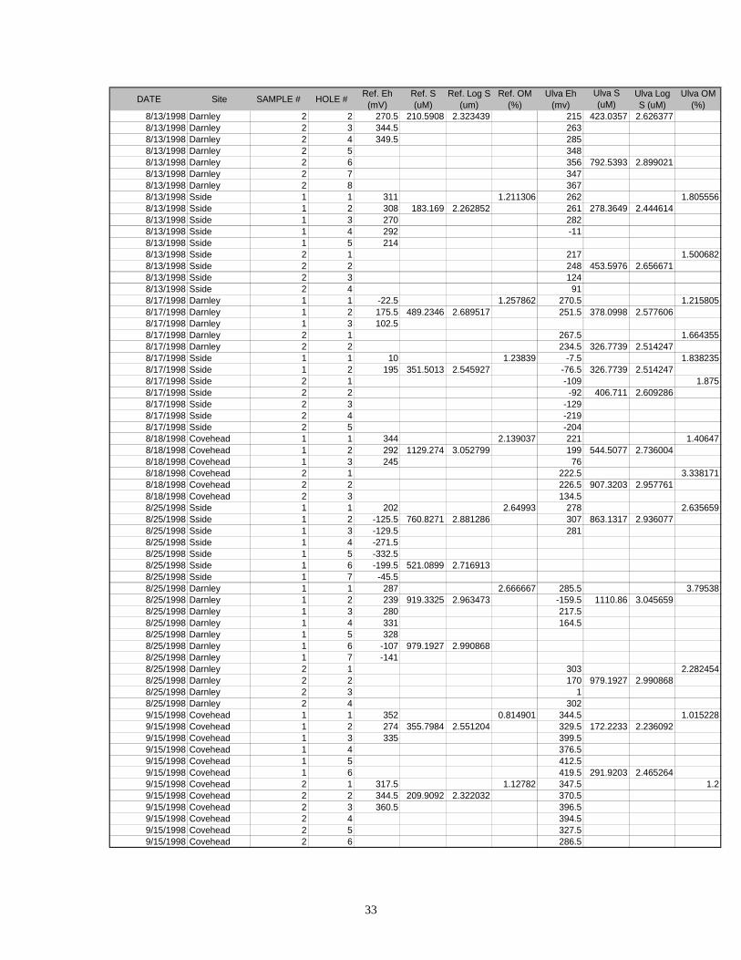
33
DATE Site SAMPLE # HOLE # Ref. Eh (mV)
Ref. S (uM)
Ref. Log S (um)
Ref. OM (%)
Ulva Eh (mv)
Ulva S (uM)
Ulva Log S (uM)
Ulva OM (%)
8/13/1998 Darnley 2 2 270.5 210.5908 2.323439 215 423.0357 2.6263778/13/1998 Darnley 2 3 344.5 2638/13/1998 Darnley 2 4 349.5 2858/13/1998 Darnley 2 5 3488/13/1998 Darnley 2 6 356 792.5393 2.8990218/13/1998 Darnley 2 7 3478/13/1998 Darnley 2 8 3678/13/1998 Sside 1 1 311 1.211306 262 1.8055568/13/1998 Sside 1 2 308 183.169 2.262852 261 278.3649 2.4446148/13/1998 Sside 1 3 270 2828/13/1998 Sside 1 4 292 -118/13/1998 Sside 1 5 2148/13/1998 Sside 2 1 217 1.5006828/13/1998 Sside 2 2 248 453.5976 2.6566718/13/1998 Sside 2 3 1248/13/1998 Sside 2 4 918/17/1998 Darnley 1 1 -22.5 1.257862 270.5 1.2158058/17/1998 Darnley 1 2 175.5 489.2346 2.689517 251.5 378.0998 2.5776068/17/1998 Darnley 1 3 102.58/17/1998 Darnley 2 1 267.5 1.6643558/17/1998 Darnley 2 2 234.5 326.7739 2.5142478/17/1998 Sside 1 1 10 1.23839 -7.5 1.8382358/17/1998 Sside 1 2 195 351.5013 2.545927 -76.5 326.7739 2.5142478/17/1998 Sside 2 1 -109 1.8758/17/1998 Sside 2 2 -92 406.711 2.6092868/17/1998 Sside 2 3 -1298/17/1998 Sside 2 4 -2198/17/1998 Sside 2 5 -2048/18/1998 Covehead 1 1 344 2.139037 221 1.406478/18/1998 Covehead 1 2 292 1129.274 3.052799 199 544.5077 2.7360048/18/1998 Covehead 1 3 245 768/18/1998 Covehead 2 1 222.5 3.3381718/18/1998 Covehead 2 2 226.5 907.3203 2.9577618/18/1998 Covehead 2 3 134.58/25/1998 Sside 1 1 202 2.64993 278 2.6356598/25/1998 Sside 1 2 -125.5 760.8271 2.881286 307 863.1317 2.9360778/25/1998 Sside 1 3 -129.5 2818/25/1998 Sside 1 4 -271.58/25/1998 Sside 1 5 -332.58/25/1998 Sside 1 6 -199.5 521.0899 2.7169138/25/1998 Sside 1 7 -45.58/25/1998 Darnley 1 1 287 2.666667 285.5 3.795388/25/1998 Darnley 1 2 239 919.3325 2.963473 -159.5 1110.86 3.0456598/25/1998 Darnley 1 3 280 217.58/25/1998 Darnley 1 4 331 164.58/25/1998 Darnley 1 5 3288/25/1998 Darnley 1 6 -107 979.1927 2.9908688/25/1998 Darnley 1 7 -1418/25/1998 Darnley 2 1 303 2.2824548/25/1998 Darnley 2 2 170 979.1927 2.9908688/25/1998 Darnley 2 3 18/25/1998 Darnley 2 4 3029/15/1998 Covehead 1 1 352 0.814901 344.5 1.0152289/15/1998 Covehead 1 2 274 355.7984 2.551204 329.5 172.2233 2.2360929/15/1998 Covehead 1 3 335 399.59/15/1998 Covehead 1 4 376.59/15/1998 Covehead 1 5 412.59/15/1998 Covehead 1 6 419.5 291.9203 2.4652649/15/1998 Covehead 2 1 317.5 1.12782 347.5 1.29/15/1998 Covehead 2 2 344.5 209.9092 2.322032 370.59/15/1998 Covehead 2 3 360.5 396.59/15/1998 Covehead 2 4 394.59/15/1998 Covehead 2 5 327.59/15/1998 Covehead 2 6 286.5