Table of Contents: NMGS 24th Field ConferenceGround Water in the Navajo Sandstone in the Black Mesa...
9
Gu ideb ook of Vonument Valley and Vicinity Arizona and Utah Edited by H. L. JAMES NEW MEXICO GEOLOGICAL SOCIETY Twenty-fourth Field Conference October 4-6, 1973
Transcript of Table of Contents: NMGS 24th Field ConferenceGround Water in the Navajo Sandstone in the Black Mesa...
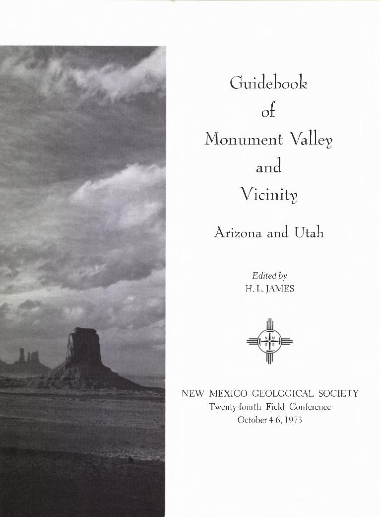
Guidebook
ofVonument Valley
and
Vicinity
Arizona and Utah
Edited by
H. L. JAMES
NEW MEXICO GEOLOGICAL SOCIETY
Twenty-fourth Field Conference
October 4-6, 1973
CONTENTS
President's Message ............................................................................................................................................................................ vi
Foreword ..............................................................................................................................................................................................vii
Committees .........................................................................................................................................................................................viii
Publications ................................................................................................................................................................................ ………x
Schedule .............................................................................................................................................................................................. xi
ROAD LOGSFirst Day: Farmington, New Mexico, to Kayenta, Arizona, via Shiprock, Four Corners, Aneth,
Bluff, Cedar Mesa, Goosenecks and Mexican Hat ........................................................................................................1
Second Day: Kayenta, Arizona, to Black Mesa and Navajo National Monument ................................................................................ 26
Monument Valley Navajo Tribal Park .......................................................................................................................... 37
Third Day: Kayenta, Arizona, to Gallup, New Mexico, via Dinnehotso, Rock Point, Round Rock,Many Farms, Chinle, Canyon de Chelly, Ganado, St. Michaels, Hunters Point and Lupton ....................................... 46
A R T I C L E S
Geomorphology of the Navajo Country .................................................................................................................. W. Lee Stokes 61
Permianland: The Rocks of Monument Valley D L. Baars 68
Triassic Rocks of Northeast Arizona andAdjacent Areas ......................................................................................................... Robert B. O'Sullivan and Morris W. Green 72
Jurassic Rocks of Northeast Arizona andAdjacent Areas ...................................................................................................... Robert B. O'Sullivan and Lawrence C. Craig 79
Cretaceous Stratigraphy of the Four Corners Area ............................................................................................ Robert G. Young 86
Structural Framework and Tectonic Evolution of the Four Corners Regionof the Colorado Plateau ............................................................................................................................................. Lee A. Woodward 94
Vertebrates from the Cutler Group of Monument Valley and Vicinity .............................................................. Peter Paul Vaughn 99
Tertiary Igneous Rocks of the Navajo Country, Arizona,New Mexico and Utah J Paul Fitzsimmons 106
Engineering Geology of the Hogback Monocline: A New Approach to BackslopeDesign in Titled Sedimentary Rocks ...................................................................................................................... Warren T. Bennett 110
Pebbles from the Chinle and Morrison Formations .......................................................................................... Constance Nuss Dodge 114
Regional Stratigraphic Control of the Search for Pennsylvanian Petroleum,Southern Monument Upwarp, Southeastern Utah .......................................................................................... Sherman A. Wengerd 122
The Uranium Deposits of Northeastern Arizona ............................................................... William L. Chenoweth and Roger C. Malan 139
iv
Ground Water in the Navajo Sandstone in theBlack Mesa Area, Arizona E H. McGavock and Gary W. Levings 150
Lexicon of Stratigraphic Names of the Monument Valley-Four Corners Region ................................................................................................................................................. Stuart A. Northrop 157
Ancient Cultures of the Southwest ............................................................................................................................................ Martin Link 177Navajo History: A 3000-year Sketch .............................................................................................................................. Editha L. Watson 181
Hole-in-the-Rock Expedition ................................................................................................................................................ David E. Miller 186
Navajo Rugs: The Regional Style H L. James 192
Movie-Making in Monument Valley .................................................................................................................................. Richard E. Klinck 199
ABSTRACTS
Abstracts of Technical Papers, New Mexico Geological Society, 27th Annual Spring Meeting:Energy Crisis Symposium, May 3-4, 1973, Albuquerque, New Mexico .............................................................................................204
Business and Professional Directory .......................................................................................................................................... 207
PRESIDENT'S MESSAGE
Most presidents of the New Mexico Geological Society end their term of office in a state of shock thatsuch a loosely run organization could function so well. I find myself in the same state of awe. VicePresident Bill Hiss, working with John Shomaker and the officers of several other natural resourcessocieties, put together an excellent symposium on the energy crisis for our annual meeting. Total time fromdecision to event was 31/2 months. Manuscripts from the symposium will be published as a New MexicoState Bureau of Mines and Mineral Resources circular.
The decision to go to Monument Valley with this year's field conference was made at a joint meeting ofthe old and new officers November 3, 1972. Total time from decision to event was 11 months; this is anunusually long time in the N.M.G.S., since we jumped the gun two months before taking office. The trip is aH. L. James creation; he proposed it, selected the committee chairmen, helped with the road logging, did thephotography, and edited the guidebook. All this after having done the same thing for the verysuccessful San Luis Basin trip only two years earlier! He had some outstanding lieutenants, however: SidAsh—General Chairman, Don Baars—Road Log Chairman, Jack Ellingson—Caravan Chairman, J. L.Kunkler—Advertising Chairman, Bob Kelley—Registration Chairman and Martin Link—arrangements withthe Navajo Tribe. In addition, Robert O'Sullivan and Bill Chenoweth made indispensable contributions tothe road logs. Many of these people also contributed papers to the guidebook, as did a host of otherauthors. So the excellent guidebook in your hands and the three days of enjoyable geology, scenery andcamaraderie are the product of many people giving unselfishly of their time and talents. Behind the scenes,however, is the "subsidy" of staff time and resources contributed year after year by the State HighwayDepartment, the United States Geological Survey, the New Mexico Bureau of Mines and Mineral Resources,and the geology departments of the region. It is this "care" that provides the stability of the Society andhas made possible twenty-four successive field conferences. On behalf of the Society, I wish to extend mysincere thanks to all concerned and a hearty welcome to Monument Valley '73.
Charles E. Chapin
vi
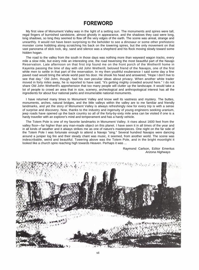
FOREWORDMy first view of Monument Valley was in the light of a setting sun. The monuments and spires were tall,
regal fingers of burnished sandstone, almost ghostly in appearance, and the shadows they cast were long,long shadows, so long they seemed to flow off the very edges of the earth. The scene was unreal, strange andunearthly. It would not have been surprising to the beholder to see a dinosaur or some other prehistoricmonster come hobbling along scratching his back on the towering spires, but the only movement on thatvast panorama of slick rock, sky, sand and silence was a shepherd and his flock moving slowly toward somehidden hogan.
The road to the valley from the south in those days was nothing more than wayward wagon tracks, everymile a slow mile, but every mile an interesting one, the road traversing the most beautiful part of the NavajoReservation. Late afternoon on that first trip found me on the front porch of the Wetherill home inKayenta passing the time of day with old John Wetherill, beloved friend of the Navajos, one of the firstwhite men to settle in that part of the reservation. In my then youthful exuberance I said some day a finepaved road would bring the whole world past his door. He shook his head and answered, "Hope I don't live tosee that day." Old John, though, had his own peculiar ideas about privacy. When another white tradermoved in forty miles away, he is reported to have said, "it's getting mighty crowded around here." I do notshare Old John Wetherill's apprehension that too many people will clutter up the landscape. It would take alot of people to crowd an area that in size, scenery, archeological and anthropological interest has all theingredients for about four national parks and innumerable national monuments.
I have returned many times to Monument Valley and know well its vastness and mystery. The buttes,monuments, arches, natural bridges, and the little valleys within the valley are to me familiar and friendlylandmarks, and yet the story of Monument Valley is always refreshingly new for every trip is with a senseof surprise and discovery. Now, thanks to the industry and ingenuity of young engineers seeking uranium,jeep roads have opened up the back country so all of the forty-by-sixty mile area can be visited if one is ahardy traveller with an explorer's mind and temperament and has a hardy vehicle.
The Totem Pole is one of my favorite landmarks in Monument Valley. It rises about 1600 feet from thevalley floor—far higher than any man-made object on this planet. I have seen it in all times of the year andin all kinds of weather and it always strikes me as one of nature's masterpieces. One night on the far side ofthe Totem Pole I was fortunate enough to attend a Navajo "sing." Several hundred Navajos were dancingaround a juniper log fire and their steady chant was music, it seemed, from another world. The scene wasindescribable, weird and beautiful. Towering above was the Totem Pole, and in the bright moonlight itlooked like a church spire reaching high towards Heaven. Perhaps it was ...
Raymond Carlson, Editor EmeritusArizona Highways
vii
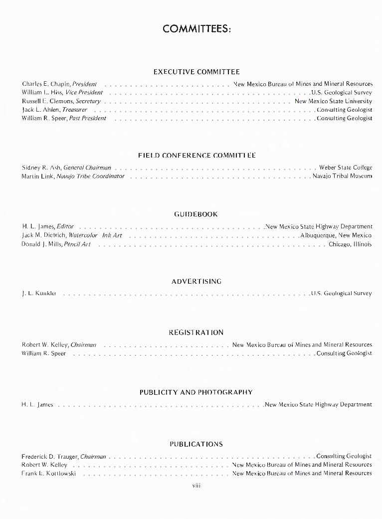
COMMITTEES:
EXECUTIVE COMMITTEE
Charles E. Chapin, President
New Mexico Bureau of Mines and Mineral ResourcesWilliam L. Hiss, Vice President
U.S. Geological Survey
Russell E. Clemons, Secretary
New Mexico State UniversityJack L. Ahlen, Treasurer
Consulting Geologist
William R. Speer, Past President
Consulting Geologist
FIELD CONFERENCE COMMITTEE
Sidney R. Ash, General Chairman Weber State CollegeMartin Link, Navajo Tribe Coordinator Navajo Tribal Museum
GUIDEBOOK
H. L. James, Editor New Mexico State Highway DepartmentJack M. Dietrich, Watercolor—Ink Art Albuquerque, New MexicoDonald J. M i I Is, Pencil Art Chicago, Illinois
ADVERTISING
J. L. Kunkler U.S. Geological Survey
REGISTRATION
Robert W. Kelley, Chairman New Mexico Bureau of Mines and Mineral ResourcesWilliam R. Speer Consulting Geologist
PUBLICITY AND PHOTOGRAPHY
H. L. James New Mexico State Highway Department
PUBLICATIONS
Frederick D. Trauger, Chairman Consulting GeologistRobert W. Kelley New Mexico Bureau of Mines and Mineral ResourcesFrank E. Kottlowski New Mexico Bureau of Mines and Mineral Resources
viii
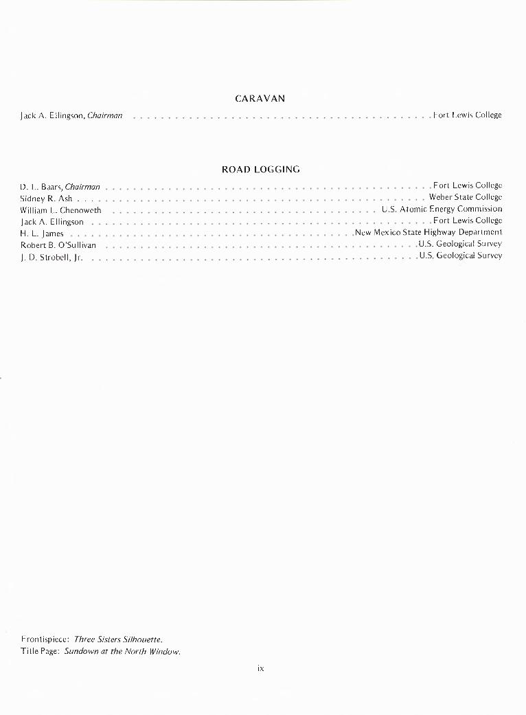
CARAVAN
Jack A. Ellingson, Chairman Fort Lewis College
ROAD LOGGING
D. L. Baars, Chairman Fort Lewis CollegeSidney R. Ash Weber State CollegeWilliam L. Chenoweth U S Atomic Energy CommissionJack A. Ellingson Fort Lewis CollegeH. L. James New Mexico State Highway DepartmentRobert B. O'Sullivan U.S. Geological Survey
J. D. Strobel!, Jr. U.S. Geological Survey
Frontispiece: Three Sisters Silhouette.Title Page: Sundown at the North Window.
ix
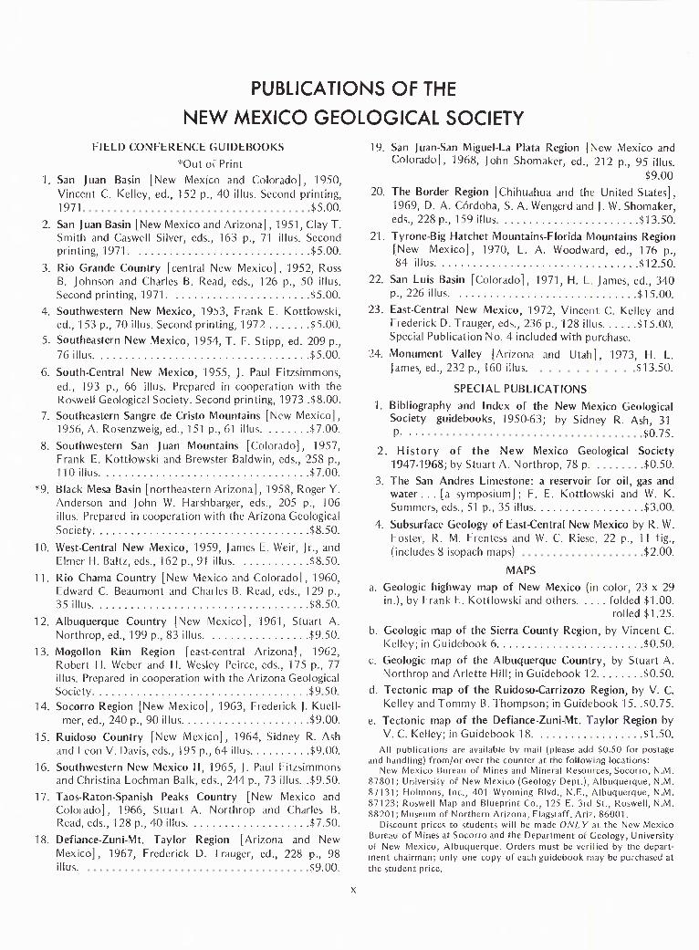
PUBLICATIONS OF THENEW MEXICO GEOLOGICAL SOCIETY
FIELD CONFERENCE GUIDEBOOKS*Out of Print
1. San Juan Basin [New Mexico and Colorado], 1950,Vincent C. Kelley, ed., 152 p., 40 illus. Second printing,1971 $5.00.
2. San Juan Basin [New Mexico and Arizona], 1951, Clay T.Smith and Caswell Silver, eds., 163 p., 71 illus. Secondprinting, 1971. $5.00.
3. Rio Grande Country [central New Mexico], 1952, RossB. Johnson and Charles B. Read, eds., 126 p., 50 illus.Second printing, 1971. $5.00.
4. Southwestern New Mexico, 1953, Frank E. Kottlowski,ed., 153 p., 70 illus. Second printing, 1972 $5.00.
5. Southeastern New Mexico, 1954, T. F. Stipp, ed. 209 p.,76 illus. $5.00.
6. South-Central New Mexico, 1955, J. Paul Fitzsimmons,ed., 193 p., 66 illus. Prepared in cooperation with theRoswell Geological Society. Second printing, 1973 .$8.00.
7. Southeastern Sangre de Cristo Mountains [New Mexico],1956, A. Rosenzweig, ed., 151 p., 61 illus. $7.00.
8. Southwestern San Juan Mountains [Colorado], 1957,Frank E. Kottlowski and Brewster Baldwin, eds., 258 p.,110 illus. $7.00.
*9. Black Mesa Basin [northeastern Arizona], 1958, Roger Y.Anderson and John W. Harshbarger, eds., 205 p., 106illus. Prepared in cooperation with the Arizona GeologicalSociety. $8.50.
10. West-Central New Mexico, 1959, James E. Weir, Jr., andElmer H. Baltz, eds., 162 p., 91 illus. $8.50.
11. Rio Chama Country [New Mexico and Colorado], 1960,Edward C. Beaumont and Charles B. Read, eds., 129 p.,35 illus. $8.50.
12. Albuquerque Country [New Mexico], 1961, Stuart A.Northrop, ed., 199 p., 83 illus.
13. Mogollon Rim Region [east-central Arizona], $9.50.Robert H. Weber and H. Wesley Peirce, eds., 175 p., 77illus. Prepared in cooperation with the Arizona GeologicalSociety $9 50
14. Socorro Region [New Mexico], 1963, Frederick J. Kuell-mer, ed., 240 p., 90 illus $9.00.
15. Ruidoso Country [New Mexico], 1964, Sidney R. Ashand Leon V. Davis, eds., 195 p., 64 illus $9.00.
16. Southwestern New Mexico II, 1965, J. Paul Fitzsimmonsand Christina Lochman Balk, eds., 244 p., 73 illus. .$9.50.
17. Taos-Raton-Spanish Peaks Country [New Mexico andColorado], 1966, Stuart A. Northrop and Charles B.Read, eds., 128 p., 40 illus. $7.50.
18. Defiance-Zuni-Mt. Taylor Region [Arizona and NewMexico], 1967, Frederick D. Trauger, ed., 228 p., 98illus. $9.00.
19. San Juan-San Miguel-La Plata Region [New Mexico andColorado], 1968, John Shomaker, ed., 212 p., 95 illus.
$9.0020. The Border Region [Chihuahua and the United States],
1969, D. A. Cordoba, S. A. Wengerd and J. W. Shomaker,eds., 228 p., 159 illus. $13.50.
21. Tyrone-Big Hatchet Mountains-Florida Mountains Region[New Mexico], 1970, L. A. Woodward, ed., 176 p.,84 illus. $12.50.
22. San Luis Basin [Colorado], 1971, H. L. James, ed., 340p., 226 illus. $15.00.
23. East-Central New Mexico, 1972, Vincent C. Kelley andFrederick D. Trauger, eds., 236 p., 128 illus $15.00.Special Publication No. 4 included with purchase.
24. Monument Valley [Arizona and Utah], 1973, H. L.James, ed., 232 p., 160 illus. $13.50.
SPECIAL PUBLICATIONS1. Bibliography and Index of the New Mexico Geological
Society guidebooks, 1950-63; by Sidney R. Ash, 31 $0.75.
2. History of the New Mexico Geological Society1947-1968; by Stuart A. Northrop, 78 p. $0.50.
3. The San Andres Limestone: a reservoir for oil, gas andwater ... [a symposium] ; F. E. Kottlowski and W. K.Summers, eds., 51 p., 35 illus $3 00
4. Subsurface Geology of East-Central New Mexico by R. W.Foster, R. M. Frentess and W. C. Riese, 22 p., 11 fig.,(includes 8 isopach maps) $2.00.
MAPSa. Geologic highway map of New Mexico (in color, 23 x 29
in.), by Frank E. Kottlowski and others. .... folded $1.00.rolled $1.25.
b. Geologic map of the Sierra County Region, by Vincent C.Kelley; in Guidebook 6 $0.50.
c. Geologic map of the Albuquerque Country, by Stuart A.Northrop and Arlette Hill; in Guidebook 12 $0.50.
d. Tectonic map of the Ruidoso-Carrizozo Region, by V. C.Kelley and Tommy B. Thompson; in Guidebook 15 $0.75.
e. Tectonic map of the Defiance-Zuni-Mt. Taylor Region byV. C. Kelley; in Guidebook 18.
$All publications are available by mail (please add $0.50 for po10s.t5age.and handling) from/or over the counter at the following locations:
New Mexico Bureau of Mines and Mineral Resources, Socorro, N.M.87801; University of New Mexico (Geology Dept.), Albuquerque, N.M.87131; Holmons, Inc., 401 Wyoming Blvd., N.E., Albuquerque, N.M.87123; Roswell Map and Blueprint Co., 125 E. 3rd St., Roswell, N.M.88201; Museum of Northern Arizona, Flagstaff, Ariz. 86001.
Discount prices to students will be made ONLY at the New MexicoBureau of Mines at Socorro and the Department of Geology, Universityof New Mexico, Albuquerque. Orders must be verified by the depart-ment chairman; only one copy of each guidebook may be purchased atthe student price.
x
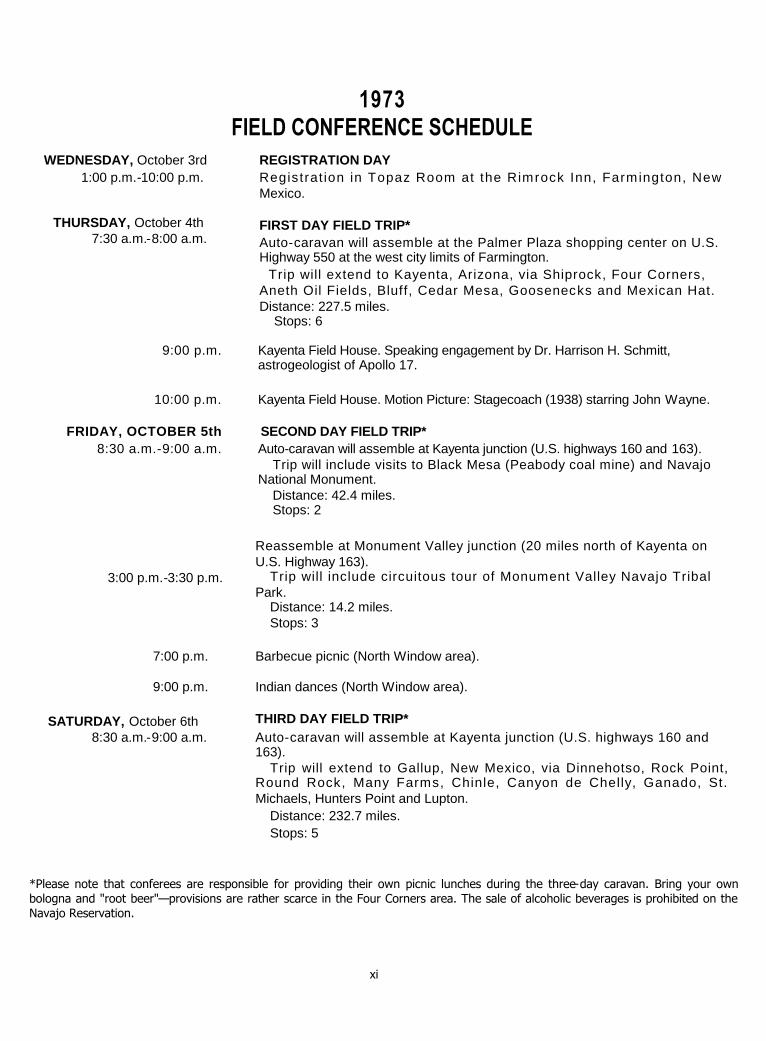
1973FIELD CONFERENCE SCHEDULE
REGISTRATION DAYRegistrat ion in Topaz Room at the Rimrock Inn, Farmington, NewMexico.
FIRST DAY FIELD TRIP*Auto-caravan will assemble at the Palmer Plaza shopping center on U.S.Highway 550 at the west city limits of Farmington.
Trip will extend to Kayenta, Arizona, via Shiprock, Four Corners,Aneth Oil Fields, Bluff, Cedar Mesa, Goosenecks and Mexican Hat.Distance: 227.5 miles.
Stops: 6
9:00 p.m. Kayenta Field House. Speaking engagement by Dr. Harrison H. Schmitt,astrogeologist of Apollo 17.
10:00 p.m. Kayenta Field House. Motion Picture: Stagecoach (1938) starring John Wayne.
FRIDAY, OCTOBER 5th SECOND DAY FIELD TRIP*8:30 a.m.-9:00 a.m. Auto-caravan will assemble at Kayenta junction (U.S. highways 160 and 163).
Trip will include visits to Black Mesa (Peabody coal mine) and NavajoNational Monument.
Distance: 42.4 miles.Stops: 2
Reassemble at Monument Valley junction (20 miles north of Kayenta onU.S. Highway 163).
Trip will include circuitous tour of Monument Valley Navajo TribalPark.
Distance: 14.2 miles.Stops: 3
Barbecue picnic (North Window area).
Indian dances (North Window area).
THIRD DAY FIELD TRIP*Auto-caravan will assemble at Kayenta junction (U.S. highways 160 and163).
Trip will extend to Gallup, New Mexico, via Dinnehotso, Rock Point,Round Rock, Many Farms, Chinle, Canyon de Chelly, Ganado, St.Michaels, Hunters Point and Lupton.
Distance: 232.7 miles.Stops: 5
*Please note that conferees are responsible for providing their own picnic lunches during the three-day caravan. Bring your ownbologna and "root beer"—provisions are rather scarce in the Four Corners area. The sale of alcoholic beverages is prohibited on theNavajo Reservation.
xi
WEDNESDAY, October 3rd1:00 p.m.-10:00 p.m.
THURSDAY, October 4th7:30 a.m.-8:00 a.m.
3:00 p.m.-3:30 p.m.
7:00 p.m.
9:00 p.m.
SATURDAY, October 6th8:30 a.m.-9:00 a.m.