PTC40_Fina Report_final - WMO
160
WORLD METEOROLOGICAL ORGANIZATION AND ECONOMIC AND SOCIAL COMMISSION FOR ASIA AND THE PACIFIC WMO/ESCAP PANEL ON TROPICAL CYCLONES FORTIETH SESSION Colombo, Sri Lanka (25 February – 1 March 2013) FINAL REPORT ESCAP WMO
Transcript of PTC40_Fina Report_final - WMO

WORLD METEOROLOGICAL ORGANIZATION
AND
ECONOMIC AND SOCIAL COMMISSION
FOR ASIA AND THE PACIFIC
WMO/ESCAP PANEL ON TROPICAL CYCLONES
FORTIETH SESSION
Colombo, Sri Lanka
(25 February – 1 March 2013)
FINAL REPORT
ESCAP WMO

1
GENERAL SUMMARY OF THE WORK OF THE SESSION
1. ORGANIZATION OF THE SESSION The fortieth session of the WMO/ESCAP Panel on Tropical Cyclones (PTC) hosted by Sri Lanka was held in Colombo, Sri Lanka from 25 February to 1 March 2013. The session was attended by 33 participants from seven of the eight Members of the PTC, namely, Bangladesh, India, Maldives, Oman, Pakistan, Sri Lanka and Thailand. It was also attended by observers from China and ESCAP/WMO Typhoon Committee, and representatives of United Nations Educational Scientific and Cultural Organization (UNESCO) the Intergovernmental Oceanographic Commission (IOC), International Civil Aviation Organization (ICAO), World Meteorological Organization (WMO), Economic and Social Commission for the Asia and the Pacific (ESCAP) and PTC Secretariat. The list of the participants as well as the capacities in which they attended is given in Appendix I . 1.1 Opening of the session 1.1.1 The opening ceremony of the fortieth session of PTC was commenced at 2:00 p.m. on Tuesday, 26 February 2013 at the Taj Samudra Hotel in Colombo. Representing the Government of Sri Lanka, Hon. Mahinda Amarawera, Minister of Disaster Management, Hon. Duleep Wijesekara, Deputy Minister of Disaster Management, and Ms S. M. Mohamed, Secretary to the Ministry of Disaster Management attended the opening ceremony. 1.1.2 On behalf of the Government of Sri Lanka, Hon. Mahinda Amarawera extended his warmest welcome to all the delegations and participants. He stated that development of meteorological service in Sri Lanka is a prime concern of the government. He informed the Panel that plans have already been developed to start a project to upgrade the Department of Meteorology. In addition, He commended the role played by WMO in prmoting international cooperation in weather, climate and related issues. 1.1.3 Mr Sunil Kariyawasam, Permanent Representative of Sri Lanka with WMO, welcomed all participants. He mentioned that the cooperative and coordinating activities have been successfully maintained since the commencement of the WMO/ESCAP Panel on Tropical Cyclones for the betterment of our society by improving the meteorological and hydrological services. He stressed that the role of Panel of Tropical Cyclones is critical for reducing the risk of tropical cyclone disasters in the region. In fact, Panel Members have managed to decrease the death toll due to meteorological disasters in the past decades. However, climate change and human activity have made the climate and weather pattern more complex. Mr Kariyawasam encouraged the Members to actively tackle the new issues and wished a great success for further development of meteorological and hydrological services in the Panel region. 1.1.4 The Secretary of the Typhoon Committee, Mr Olavo Rasquinho emphasized in his opening address that the realization of a PTC/TC joint session, as proposed by the Typhoon Committee at its 45th Session, would be an excellent opportunity to discuss the implementation of the Synergized Standard Operating Procedures for Coastal Multi-hazards Early Warning System (SSOP) Project that was jointly launched by PTC and TC in August 2012. 1.1.5 Mr. Arif Mahmood, Secretary of the PTC informed the Panel that it is his great pleasure to attend the 40th Session of the WMO/ESCAP Panel on Tropical Cyclones for the Bay of Bengal and the Arabian Sea in Colombo, Sri Lanka. He extended his sincere thanks to the Government of Sri Lanka for hosting the 40th Session of PTC and wished all the distinguished delegates and guests a pleasant and comfortable stay in Colombo, Sri Lanka. He stated that PTC region comprises of diversified and complex topographic features which includes the highest mountains, glaciers, forests, fertile lands, great deserts, and long

2
coastline which is fully exposed to the tropical cyclones and associated storm surges, tsunamis. In the recent past, Hydro-meteorological hazards have gained severity although the frequency of events have reduced a little bit but relocated their boundaries. PTC region is vulnerable both to tropical cyclones, associated storm surges and flash floods. Tropical Cyclones and associated storm surges are considered to be one of the severe hydrometeorological disasters in our part of the world, claiming precious lives and causing damages to property and infra-structure every year. It is the responsibility of National Meteorological and Hydrological Services of PTC region to keep an eye on the changing climate patterns and let the no stone unturned for developing capacities to mitigate these challenges. Moreover, upon the guidance by WMO the adaptation of advanced technology, satellite data & imageries and numerical prediction modeling can make PTC Members capable enough to predict severe weather events. There is no doubt that meteorological community of our region is fully aware of the challenges due to the tropical cyclones and associated storm surges. PTC Members through their individual and collaborative efforts under agreed programmes of action of PTC can further improve their forecasting and warning capabilities for the safety and prosperity of their peoples. He also stated that the present session of PTC is an opportunity to take measures against the hydrometeorological disasters as well as to urge the PTC Members for developing long-term strategies to further improve their early warning systems in order to affectively address the hydrometeorological disaster risk reduction challenges in the PTC region. The establishment of PTC Working Group on Hydrology (WGH) could provide us a platform to coordinate and contribute more effectively in the Hydrological component of the Coordinated Technical Plan of PTC. 1.1.6 On behalf of Ms. Shamika Sirimanne, Chief, ESCAP/IDD, Mr. Alf Blikberg noted that the members of the PTC, and the Asia-Pacific region as a whole, were highly disaster prone. Between 1970 and 2011, almost 75 per cent of all deaths worldwide from natural disasters occurred in the Asia-Pacific region. Likewise, a person living in this region was four times more likely to be affected by a disaster than a person living in Asia, and 25 times more likely than a person living in Europe or North America. Consequently, additional investments in building resilience were required in order to promote development and protect the gains made. He also highlighted the Synergized Standard Operating Procedures (SSOP) project, which had received financial support from ESCAP's Trust Fund for Tsunami, Disaster and Climate Preparedness. This project would be implemented jointly by the TC and the PTC and focus on building resilience to multiple coastal hazards by standardizing operating procedures for early warning systems. Mr. Blikberg described the project as building a bridge between the TC and the PTC, and urged members of both intergovernmental platforms to work closely together. 1.1.7 Speaking on behalf of Mr Michel Jarraud, Secretary-General of WMO, Mr Koji Kuroiwa, Chief of Tropical Cyclone Programme Division, welcomed all the participants and expressed his appreciation to the Government of Sri Lanka for hosting the fortieth session. Mr Kuroiwa also extended his gratitude to Mr Sunil Kariwarasam, Permanent Representative of Sri Lanka with WMO and his staff for the warm welcome and hospitality and for the excellent arrangements made to ensure the success of the session. While praising the Panel for its close adherence to the motivation and great foresight of the predecessors to reduce the risk of cyclone disasters, Mr Kuroiwa stressed that demands to the tropical cyclone forecasts have been increasing in terms of more effectiveness and timeliness and that the society shows serious concern about the increase in frequency and intensity of severe weathers. In this regard, he emphasized that the present session offered an outstanding opportunity for the exchange of views needed to develop appropriate strategies for the coordinated actions and enhanced forecasting services for the total users in the Panel region including the public, media, disaster agencies and decision makers. Assuring the WMO’s support to the activities of the Panel on Tropical Cyclones, Mr Kuroiwa wished the participants for their enjoyable stay in Colombo and for fruitful and successful outcomes of the meeting.

3
1.1.8 Before the end of the opening ceremony, vote of thanks was addressed by Mr Lalith Chandrapala, Director of Department of Meteorology, Sri Lanka. 1.2 Election of the Chairman and Vice-chairman 1. 2.1 Mr Sunil H Kariyawasam (Sri Lanka) and Mr Worapat Tiewthanom (Thailand) were unanimously elected as Chairperson and Vice-chairperson of the Panel, respectively, to hold their posts until the next session. 1. 2.2 Mr Ali Shareef (Maldives) was elected as Chairperson of the drafting committee. 1.3 Adoption of the agenda The Panel adopted the agenda as given in Appendix II. 1.4 Working arrangements The Panel decided on its working hours and the arrangements for the session. 2. FOLLOW-UP ACTION ON PTC-39 2.1 A detailed review of the follow-up actions taken to the recommendations of the thirty-ninth session was carried out based on the action sheet shown in Appendix III . The progress on the activities is incorporated into the relevant paragraphs below. 2.2 The representative of WMO informed the Panel that the new Global Guide to Tropical Cyclone Forecasting will be web-based and has been developed by Mr Chip Guard, Primary Editor with the support of Australian Bureau of Meteorology (BoM). The Global Guide website will be hosted by BoM and the website is near completion. 2.3 Mr Shamsuddin Ahmed, Chairperson of the Working Group on Meteorology (WGM) reported that the workshop for a case study, which the Panel recommended WGM to hold to achieve better coordination among the forecast centers in the region, was successfully organized in Muscat, Oman in December 2012 (see paragraph 5.1,1. 5.1.2). 2.4 The Panel noted with satisfaction that, for implementation of Tropical Cyclone Ensemble Forecast Project in the Panel region, ensemble products including strike probability have become available at the IMD website (www.imd.gov.in). It has been customized to display the products from major NWP centers including European Centre for Medium-Range Weather Forecasts (ECMWF), National Centers for Environmental Prediction (NCEP), United Kingdom National Weather Service (UKMO), Japan Meteorological Agency (JMA) and Meteorological Service of Canada (MSC). 2.5 The Panel was informed by the PTC Secretariat that establishment of the focal points and mailing list of the Working Groups of Hydrology (WGH) and Disaster Prevention and Preparedness (WGDPP) was completed and distributed to the Members. 2.6 Regarding the implementation of Common Alerting Protocol (CAP), some Members expressed a concern about the actual procedures for the implementation. In this regard, the representative of WMO informed the Panel that, at the 15th session of the WMO Regional Association II held in December 2012, it was agreed to apply CAP to the tropical cyclone warning messages. He also advised that start of a dialogue between the forecast section and the communication was the first action to take in this regard. 2.7 While noting that Common Alerting Protocol (CAP) is effective in tropical cyclone warning services for disaster manger, decision makers and stake holders, the Panel felt that the Members are not well aware about CAP. The Panel therefore requested the WMO

4
Secretariat to provide relevant materials such as documents and brochures related to CAP to the Members for their better understanding of the utility of CAP and the necessary actions to be taken for its implementation. 2.8 The Panel noted that AMDAR programmes in the Panel region have made little progress in the past year. Noting that AMDAR data is effective supplement to upper-air observation programme, the Panel encourage the Members to continue to promote collaboration with airlines for developing the regional AMDAR programmes. 2.9 Ways to increase the contribution to the PTC Trust Fund were discussed. Proposed measures including an official request from WMO to the Members for increase of their contributions were further discussed under the agenda item 8 (see paragraphs 8.7 -8.10). 3. REVIEW OF THE 2012 CYCLONE SEASON 3.1 Report of RSMC – Tropical Cyclones New Delhi 3.1.1 The north Indian and adjoining land surface Ocean witnessed the formation of five cyclonic disturbances during the year 2012. Out of five disturbances three formed over the Bay of Bengal and two over the Arabian Sea. Out of the three cyclonic disturbances over the Bay of Bengal, one intensified upto the stage of cyclonic storm, NILAM, two upto the stage of deep depression. Out of two cyclonic disturbances formed over the Arabian Sea, one intensified upto the stage of cyclonic storm, MURJAN and one upto the stage of deep depression. The salient features of the cyclonic disturbances during 2012 were as follows: • The number of total cyclonic disturbances (depression and above) during the year
was significantly below normal, as only five cyclonic disturbances formed during 2012 against the normal of 13. Similarly only two cyclones formed during the year against the normal of about 5.
• Both the cyclones made landfall. The cyclone ‘MURJAN’ made landfall over Somalia, whilw the cyclonic storm, ‘NILAM’ made landfall over Tamilnadu and Puducherry coast.
• The track of the cyclone ‘NILAM’ was rare in nature as it initially moved westwards, come closer to Srilanka coast and remained stationary for about a day and then moved north-northwestwards to cross Tamilnadu coast.
• There were no cyclonic disturbances formed over the north Indian Ocean and adjoining land surface during monsoon season (June-Sep.) against the normal of 7 cyclonic disturbances. There were no cyclonic disturbances over the north Indian Ocean during the pre-monsoon season (March-May), 2012 also.
3.1.2 The summary report on the 2012 cyclone season provided by the RSMC including the tracks of the cyclonic disturbances formed over the north Indian Ocean during the period are shown in Appendix IV . 3.1.3 The Panel underlined that the primary objective of the RSMC advisories is to assist Members’ forecasting services while the warnings to the public are under the responsibility of the respective countries. However, it was of the view that a solid linkage must be maintained between the RSMC and the Members and their regional services should be closely coordinated in order to provide reliable warnings and to avoid unnecessary confusion among the people at risk in the Panel region. In this respect, the Panel recognized the need to further enhance the communication in operational forecasting between the RSMC and the Members and therefore requested the PTC Secretariat and the rapporteur of the Operational Plan to review and reestablish the list of the focal points which is given in the Annex V-A -1 of the Operational Plan.
5
3.1.4 The Panel expressed its appreciation to the RSMC New Delhi for its continued valuable support to the Members. It also expressed its hope that existing cooperation and collaboration between the Members and the RSMC New Delhi will be further strengthened though those activities. 3.2 Reports of Members on the impact of tropical cy clones 3.2.1 The representative of Bangladesh informed the Panel that Bangladesh was affected by a tropical depression in 2012. Maximum surface wind of 22 knots over Hatia, 25 kts over Sandip and 32 knots in gusts/squalls were reported from Chittagong at the time of landfall from a depression that crossed Bangladesh. Widespread rainfall occurred over Bangladesh on 10th and 11th October 2012. Two Special advisory messages were also issued to Storm Warning Centre, Bangladesh before the genesis of depression on 10th October, 2012. Damages occurred by the storm that brought high winds and heavy rains to much of Bangladesh, causing extensive damage. Forty-three people were killed and dozens injured when powerful storms lashed several upzillas of Noakhali, Bhola, Chittagong and Feni districts early yesterday. Over 200 thatched cottages in Hatia were damaged. Scores of trees along the subarnachar and Hatia were uprooted, several fishermen with their fishing trawlers remained missing. Squalls destroyed mosques and educational institutions. 3.2.2 The representative of Oman informed the Panel that Oman was not directly affected by any tropical system during 2012. However, Oman’s Forecasting Center was watching closely two tropical systems that formed and moved towards western Arabian Sea during the second tropical season of 2012. Tropical storm Murjan formed late October and made landfall in Somalian coasts. Another tropical system formed in December and reached a deep depression status according to RSMC also made landfall in the Horn of Africa. The Sultanate was affected last year by other significant weather events. On 19th of March 2012, Northern Oman was affected by a huge dust storm which originated in Southern Iran. Visibility was reduced to less than 400 meters in some areas and Muscat International Airport was closed for some time. Oman Forecasting Center issued warnings also for several flash flooding events that took place during the months of April, October, November and December last year as a result of westerly disturbances affecting Northern Oman. 3.2.3 The representative of Pakistan informed the Panel that no tropical cyclone affected Pakistan during 2012. However, during the inter-sessional period (2012-2013), PMD undertook up-gradations in context of its national responsibilities to provide better services in the fields of meteorology, hydrology, climate change & emerging issues and seismology. 3.2.4 The representative of Sri Lanka informed the Panel that there were no tropical cyclones crossing Sri Lanka during the year. However, Cyclone Nilam developed in the Bay of Bengal, mostly to the east of north eastern coast of the island propagated closer and influenced the weather conditions of the island and North eastern seas during 27th October to 1st November. It became a low pressure area by 27th and deepened in to a depression by 28th and further intensified in to a Tropical cyclone named Nilam by 30th. The system moved in westward at the beginning and then, turned towards the southeast direction getting closer to the Sri Lankan coast and moved away after 30th towards north-northwest direction. Under the influence of the cyclone, north-eastern parts were initially affected and later western and south-western parts were badly affected due to the convergence associated with feeder bands even after entering to the land on 31st October. The recorded strongest wind was 28 knots at Galle (South) on 31st night and the heaviest rainfall was 187.2mm from Kantalai (Eastern Province) on 28th. There were 3 deaths, 49 housed completely damaged and over 69,000 people were reported to be affected. However, there are no reports of casualties from maritime community during this period. 3.2.5 The representative of Thailand informed the Panel that no tropical cyclone around the Indian Ocean entered and affected Thailand in the past year. However, it was hit by a

6
tropical cyclone that was developed from the low pressure cell over the middle of the South China Sea (13.5 °N, 113.0 °E) at 0000 UTC on 30 September, namely tropical storm “Gaemi (1220).” It had peak intensity with maximum wind of 50 knots near its centre over the South China Sea. After its crossing Vietnam and Cambodia, it downgraded into the tropical depression and moved further into Sa Kaew province, Thailand on late 7 October. Gaemi became low pressure cell over the eastern and central regions of Thailand on the following day and intensified the monsoon trough which was lying across central and eastern regions of Thailand. This resulted in plentiful rain mainly over the central and eastern Thailand. The highest daily rainfall was 92.1 mm in Tak Fah District, Nakhon Sawan Province on 8 October. 3.2.6 Myanmar sent a report to the Panel that during 2012, the total number of formations into Low Pressure Areas over the Bay of Bengal was ten, of which two were intensified to depression and one became cyclonic storm “Nilam” which crossed to the southern Coast of India, near Chennai. One Low Pressure Area (LPA) occurred in July, three in August and two in September, and one depression and one Cyclonic Storm “Nilam” occurred in October, and one depression and one LPA formed in November, respectively. Storm frequency occurred in 2012 is lower than in 2011, but the rainfall amount in the whole country was normal. 3.2.7 Detailed descriptions of the 2012 cyclone season review by the Panel Members are given in Appendix V . 4. COORDINATION WITH OTHER ACTIVITIES OF THE WMO TROPICAL CYCLONE
PROGRAMME 4.1 The Panel noted that, at its 64th session (Geneva, June 2012), the WMO Executive Council gave following guidance to the Tropical Cyclone Programme (TCP):
a) Capacity development - Due consideration to developing countries, LDCs in particular.
b) Regional tropical cyclone (TC) bodies and WMO Projects. - Close linkage between TCP and other WMO Programmes through the
relevant WMO projects such as SWFDP and CIFDP. c) Improvement of Operational TC Forecasting
- Extended use of ensemble techniques including multi-model consensus forecasting and ensemble-based probabilistic guidance.
- More objective TC analyses as recommended by IWSATC. - Establishment of TC Forecaster Website.
d) Standardization of the format in TC warnings - Implementation of Common Alerting Protocol (CAP) in TC warnings. - Change of the format of TCAC advisories for aviation from text to
graphic. 4.2 The Panel was informed that all the five regional TC bodies held their annual/biennial sessions during 2012 of which the outcomes are highlighted as follows:
i) The 14th session of the RA V Tropical Cyclone Committee was held in Apia, Samoa from the 16 to 20 July 2012 in conjunction with the 3rd Meeting of the ICG/PTWS Regional Working Group on Tsunami Warning and Mitigation in the South-West Pacific Region (14 July).
ii) The 20th session of the RA I Tropical Cyclone Committee (TCC) was held in Maputo, Mozambique from 3 to 7 September 2012. The Committee carried out a complete reformation of its Technical Plan to make it more strategic. It also reconfirmed the full implementation of the new storm-naming procedures.
iii) The 34th session of the RA IV Hurricane Committee was held in Ponte Vedra Beach, Florida, USA from 11 to 15 April 2012. The Committee re-established the backup arrangements for warning between the Members and decided to conduct an experiment in forecasting of storms before formation.

7
iv) The 45th session of the ESCAP/WMO Typhoon Committee was held in Hong Kong, China from 29 January to 1 February 2013. The Committee published the 2nd Assessment Report on the Influence of Climate Change on TC in the Typhoon Committee Region. It also endorsed the implementation of the SSOP Project jointly with the Panel on Tropical Cyclones.
4.3 For the capacity development in TC forecasting, TCP held a number of workshops and training events, in cooperation with the partner Programmes of WMO, including the RA IV Workshop on Hurricane Forecasting and Warning, and Public Weather Services which was held at RSMC Miami, Florida, USA, from 12 to 23 March 2012. It also organized attachment trainings jointly with the RSMCs Tokyo and New Delhi which invited experts of Philippines/Viet Nam and Bangladesh/Myanmar/Oman, respectively. 4.4 The Panel noted with pleasure that the TC Forecaster Website will be launched in March 2013 with the support of Hong Kong, China as host. The Website is aimed to assist forecasters in their operational forecasting of tropical cyclones. It will function as a portal to various websites offering data/products of TC analyses and forecasts and will also provide research outcomes and training materials, thus serving as a comprehensive source of information for TC forecasters. The Committee also noted that the Global Guide to Tropical Cyclone Forecasting has been updated with Mr Chip Guard of Guam, USA as Chief Editor. The new Guide will be hosted by Australia Bureau of Meteorology and mainly Web-based for widespread access by forecasters. It is also expected to achieve synergetic effect with the TC Forecaster Website. 4.5 As a major part of its collaborations with other WMO Programmes, TCP has been working closely with the Global Data Processing and Forecasting System (GDPFS) for Severe Weather Demonstration Project (SWFDP) in the regions of Africa and South Pacific. The Committee noted with pleasure that SWFDP for the South-east Asia is expected to be fully launched in 2013 with the SWFSP workshop for the Members of the Committee as well as the WMO/ESCAP Panel on Tropical Cyclones, which is planned to be held in Macao, China from 8-19 April 2013. 4.6 The Panel recalled the discussion at the previous session (5-9 March 202, Myanmar) regarding the National Sub-Project for JCOMM/CHy Coastal Inundation Forecasting Demonstration Project (CIFDP) in Bangladesh, denoted as CIFDP-B. It congratulated the Government of Bangladesh on successfully completing the Phase 1 (Information Gathering - Project adaptation) of the project, by finalizing the Definitive National Agreement (DNA) in participation of the key national and regional stakeholders, including the Bangladesh Meteorological Department (BMD), Department of Disaster Management (DDM), Cyclone Preparedness Programme (CPP) and Regional Integrated Multi-Hazard Early Warning System (RIMES). The CIFDP Steering Group (PSG) has completed the review of CIFDP-B Phase 1, based on the progress report prepared by Bangladesh National Coordination Team (NCT), and approved for the implementation of Phase 2 and thereafter. 4.7 The Panel also noted with appreciation that the WMO Secretariat has successfully secured financial resources for the full cycle of CIFDP-B implementation, from the USAID. Based on these progresses, the PSG at its 4th meeting (22-23 February 2012, Fiji) reviewed and approved the workplan for the CIFDP-B Phase 2 (until 2014), pending the further discussion with BMD and system developers. The core component of the Phase 2 would be the development of a (pre-operational) integrated Coastal Inundation Forecasting system, to be operated by BMD after testing and validation. It is expected that, in collaboration with the national technical partners (including BMD), several international partners would participate in the Phase-2 implementation who have been actively assisting BMD to enhance capabilities for marine meteorological and oceanographic forecasting - such as RSMC-TC and JMA.

8
4.8 The Panel recognized that, once the CIFDP-B is completed, the developed coastal inundation forecasting system should be operated and maintained by BMD itself, and therefore the operational structure and procedure should fully take the progress into account in view of ensuring the operation of the coastal inundation forecasting by the NMHS (BMD for the case of CIFDP-B) in the future. In this context, the Panel agreed to continue to collaborate with CIFDP and its outcomes be duly shared by the Members. 4.9 The Panel noted that, among the priority actions of TCP for 2013 and beyond such as organization of regional workshops and TC committees’ sessions, the Programme will give its special emphasis on 1) maximizing the synergies of Tropical Cyclone Forecaster Website and the TCP websites Global Guide on Tropical Cyclone Forecasting and 2) streamlining the training courses and workshops. 5. REVIEW OF THE COORDINATED TECHNICAL PLAN AND CON SIDERATION OF
THE WORK PROGRAMME FOR THE NEXT FOUR YEARS (Agenda item 8) Consideration of CTP for 2013-2015 5.0.1 The Panel considered the 2013 Annual Operating Plan (AOP) of the five components. It adopted the 2013 AOP as shown in the Appendix VI. 5.0.2 As regards the 2013 AOPs of other components, the Panel decided to maintain the 2012 AOPs which were adopted at the 39th session. 5.0.3 For the purpose of promoting the activities of its Working Groups on Meteorology, Hydrology and DRR, formulating more adequate AOPs, as well as developing synergies among the working groups, the Panel decided to organize an integrated workshop in advance of the 41st session with participation of the members of the three working groups. Update of the Coordinated Technical Plan (CTP) for 2014 and beyond will also be discussed at the workshop. 5.0.4 In this regard, the Panel requested the PTC Secretariat to ask for the views and comments from the Members in advance and thereby draft the updated CTP for 2014 and beyond for the discussion on the update of CTP at the workshop. The Panel also requested the PTC Secretariat and the WMO Secretariat to arrange with Members for hosting the workshop. 5.1 Meteorological Component Report of WGM 5.1.1 The Working Group of Meteorology reported the Panel about the Case-study Workshop which was held in Muscat, Oman from 17 to 19 December 2012. 5.1.2 The workshop was attended by 5 experts from the Panel Members and one representative from WMO. It discussed several important issues in operational tropical cyclone forecasting and warning services, and made a list of recommendations for future cooperation among the Members in the region. The details or the outcomes of the workshop can be found in the Appendix VII 5.1.3 The Panel agreed to the proposal of WGM to appoint Mr Khalid Khamis Saif Al-Jahwari (Oman) as Co-Chair of the Working Group. Activities of the Members

9
5.1.4 The representative of Bangladesh informed the Panel that Bangladesh Meteorological Department is in the process of strengthening of its observational network: 1) Introduction of advanced technology for observational systems with induction of automatic weather station (AWS); 2) BMD has installed Two Doppler Weather Radar at Cox’s Bazar & Khepupara for Tropical Cyclone monitoring; 3) BMD has installed one Doppler Weather Radar at Mowlvi Bazar, North-eastern part of Bangladesh for flash flood warning; 4) There are another two Weather Radar at Dhaka and Rangpur for monitoring severe local thunder storm.; 24 AWS will be installed under SAARC STORM programme at different places for Nor’westers. In addition, three Radiosode stations had been upgraded into GPS based operation. For forecast systems, a number of models like WRF, JMA- NHM model, IIT-NewDelhi Storm surge model, MRI model are in operational status, in addition to Installation of Diana by Met Norway. As results, the BMD had improved its forecast services, nowcasting of severe weather events, multi-hazard early warning and better Service delivery, and had increased accuracy of short and medium range forecast, real-time data availability and spatial & temporal coverage. 5.1.5 The representative of India informed the Panel that IMD has well established different types of observational networks, including Surface Observatories, Upper Air observatories, Meteorological Satellite and Telecommunication. They are listed as below:
� There are 709 surface observation Stations, and seventy airports provided with meteorological instruments,13 coastal stations installed with HWSR systems which are equipped with GPRS modems so that the data in real time is available at website “imdaws.com”. Under the modernization Phase - I, there have been installed a TDMA earth station along with 550 AWS and 955 ARGs. Installation of 10 GPS systems has been proposed. Also planned are to install Wind Profilers, Wind Lidars, Microwave Radiometer and GPS based Pilot Balloon Systems. On completion of the modernization phase I, IMD will have 21 DWRs in its observational network. In the II and III phase of modernization, 34 more DWRs will be procured and inducted in the total radar network of 55 DWRs to bring entire country under radar coverage. The program of installation of 20 out of 34 DWRs is expected to be completed by December, 2014.
� Met. Satellites of special relevance to TC analysis over North Indian Ocean are: INSAT and Kalpana and Oceansat-II. INSAT-3D Satellite Scheduled to be launched in 2013. It has a 6-channel Imager almost similar to GOES satellites of USA, and a 19 –channel Sounder similar to GOES satellites. It will be possible to detect night time fog more frequently and its hydro- estimator will be a better estimate of rainfall for flood monitoring etc. Megha-Tropiques mission of ISRO has the following important payloads: a) Microwave Analysis and Detection of Rain and Atmospheric Structures (MADRAS), with five channels of microwave for estimation of atmospheric water parameters in the equatorial belt; b) SAPHIR microwave humidity sounder and radiometer of 6 channels for humidity profile.
� Fifty four stations in IMD are connected with IPVPN connectivity speeds ranging from 256 Kbps to 8 Mbps. These VPN circuits are connected with High Speed Data Terminals, Doppler Weather Radar Stations, AMSS Centres and Regional Centres. one can access current weather and forecast for major Indian cities by dialing Toll free number 1800 180 1717. A network of 26 V-SATs have been installed at selected seismological observatories, Cyclone Radar stations, Cyclone Warning Centres and Meteorological Centers for reception of observational data utilizing communication transponder of INSAT. At present we have wide range of Internet services 45 Mbps. IMD is also connected to NKN (National Knowledge Network) over 1 Gbps link for internet, close user group & Telepresence services.
� India has been designated as an issuing authority under the GMDSS programme for
Meteorological Area VIII(N) India Meteorological Department is transmitting daily

10
two GMDSS bulletins, one at 0900 UTC and other at 1800 UTC. During Cyclone Season additional bulletins (4) are also being issued for GMDSS
� As regards the Meteorological Telecommunication Networks within the GTS, New Delhi telecommunication center is designated as Regional Telecommunication Hub (RTH) located on the Main Trunk Network (MTN). It links WMO together three World Meteorological Centers (WMCs) and 14 other RTHs on the MTN. It links National Meteorological Centres (NMCs) Colombo, Dhaka, Karachi, Kathmandu, Male, Muscat and Yangon in the Regional Meteorological Telecommunication Networks (RMTNs). India Meteorological Department has its National Meteorological Telecommunication Centre (NMTC) with an Automatic Message Switching computer System (AMSS) which is connected to WMO Centers on the GTS. The existing RTH switching system “TRANSMET” is the state-of-the-art technology system. It consists of two Separate Automatic Message Switching System (AMSS) for National and International data exchange. Each AMSS works in hot standby mode for 100% redundancy in case of any failure.
5.1.6 Representative of Maldives informed the Panel of their activities in the meteorological component as below.
• Upper Air Observation: Rawinsonde observations at the Meteorological Office, Gan (WMO # 43599) were done until March 2012 and thereafter due to shortage of consumables rawinsonde observations were terminated. No observations were done at Male’ (WMO # 43555) during 2012 due to unavailability of equipment and consumables. As the location of Maldives in the Indian Ocean happens to be a data sparse area in which shifting of ITCZ and phases of MJO take place. Therefore, upper air observations from both Male’ and Gan are very important to entire meteorological community in the region and globe. Maldives urge assistance from donors and Panel Members to consider rebuilding our upper air observation network.
• Surface, Rainfall and AWS observations: Maldives has 5 meteorological stations all are manned 24 hours, both synoptic and aviation reports are made on all five stations. Only one of them is categorized additionally as upper-air station. Total of 23 Automatic Weather Stations (AWS) has been installed and are in operation. However sustaining of these AWS have become difficult due to financial limitations year after year. As a result, only 9 stations are sending out data to the National Meteorological Centre at present. Across the country, Maldives has 7 rainfall stations which measure only accumulated rainfall for 24 hours and readings are collected at 0300UTC for national use only.
• Meteorological Satellites: Digital Meteorological Data Dissemination (DMDD) system donated by India Meteorological Department (IMD) receives WMO coded GTS data, half hourly cloud imagery from KALPANA and Fax charts in LRIT/HRIT format. With all of its features, DMDD helps forecasters to do more precise predictions. However, this system is facing signal loss therefore nothing has been received during 2012. The High Resolution Satellite Image Receiving System GEOSAT 500 has stopped functioning since 2010. It is required to pay a considerably high amount to the manufacturer to renew its service agreement. Meanwhile, an integrated satellite receiving system generously donated by China Meteorological Agency was installed on 25 October 2012. This CMACast system receives Satellite imageries from FY2E and FY2D series of Chinese geostationary satellites at an interval of 30 minutes. Another component of this system is the application software MICAPS (meteorological data analyzing system) which enables to display satellite pictures, surface & upper air data and NWP products and overlay different products and analysis of various weather phenomena.
11
• Doppler Weather Radar: Doppler Weather Radar received as part of Multi-hazard Early Warning System has been repaired in 2011. However, it needs further calibration of equipment by a professional and local technicians are unable to do the job. MMS have begun the process of hiring an expert to bring this system to normal.
• Numerical Weather Prediction: The system which runs WRF model gives problems time to time as the hardware become old and it is impossible to upgrade them due to financial crisis. Maldives Meteorological Service continues to use NWP output provided by RIMES, ECMWF, IMD and other web based NWP products.
• NMC’s Global Telecommunications System (GTS): MESSIR-COMM message switching system developed by COROBOR is a TCP/IP based multi-channel communication link that is capable of handling vast amount of data. Although this GTS is in operation throughout 2012, Maldives received many complains from other countries and GCOS of not receiving our SYNOP, TEMP messages through GTS. Likewise, the monthly CLIMAT report sent via GTS is also reported not received by users. Efforts have been made in late 2011 – 2012 in consultation with RTH New Delhi in this regard and still this matter needed to be taken care of and work closely to arrive at a sustainable solution.
5.1.7 The representative of Oman informed the Panel that The forecasting center continues to run high resolution Hydrodstatic and Non-Hydrostatic regional models with a plan to run WRF numerical weather prediction model. In addition, The Forecasting Center now runs a weather studio to prepare TV general weather forecasts in Arabic and English. Moreover, the network of weather stations is being expanded through Installation of additional automatic weather stations (44 land stations currently).A network of Doppler weather radars to be installed starting from June 2013. The Met Website will be updated soon with the introduction of a smart phone application for weather forecasts. 5.1.8 The representative of Pakistan informed the Panel that Pakistan Meteorological Department (PMD) during 2012, upgraded its three weather radars located at Islamabad, Karachi and Rahim Yar Khan under Japan International Cooperation Agency (JICA) / Government of Japan assisted project “Upgradation of Weather Radars Network of PMD”. JICA experts also conducted short training course for PMD technical staff. It was informed that PMD received donation of Met Instruments from China Meteorological Administration (CMA) under WMO VCP in order to further strengthen the meteorological observational network of PMD in the aftermath of devastating flooding in Pakistan during summer monsoon season 2010. The donation includes various meteorological instruments and the installation process is underway. The Panel was also informed that PMD has been using High resolution Regional Model (HRM) of DWD (the National Meteorological Service of Germany) as an operational model for Numerical Weather Prediction (NWP) since January, 2007. Initially, the model was run with 28 Km resolution which was improved to 22 Km in March 2008 and to 11 Km in September, 2010. Now, PMD has also planned to implement COSMO (COnsortium for Small-scale MOdelling) with higher resolution for NWP. Further, PMD has also established a linkage with CMA via ftp to access their NWP products. The Panel was further informed that JICA/Government of Japan under the project “Establishment of Specialized Medium Range Forecasting Centre (SMRFC) and Strengthening of Early Warning and Dissemination Network” would provide State-of-the-Art technology in order to further improve the forecasting and early warning system of PMD. The Panel has also been informed that PMD has been extending direct dialing Interactive Voice Response System facility for weather related information to general public and relevant stakeholders. 5.1.9 Representative of Sri Lanka informed the Panel that data and information exchange with RTH New Delhi internet lease line operated throughout. The system is integrated with SADIS and there are three visualizing terminals. It also provides the warning with alarm in case of information provided by PTWC, JMA and RTSP, INCOIS with regard to potential

12
tsunami situation. Strom surge model, as per WMO/ESCAP training received, is operational as a routine at the NMC. The observational activities are as follows:
• Synoptic Observations: Data reception from 22 operational stations with the two stations commenced in 2009 namely, Polonnaruwa and Moneragala (No WMO number assigned yet) was very good. Observations taken and sent in plain language by Sri Lanka navy at Trincomalee (43418) are coded at NMC. Out of RBCN stations, silent climate TEMP data, Colombo (43466), due to non-availability of continuous data and nine RBSN stations are operational. Problems of equipments/sensors of 35 Automatic Weather Systems have been mostly settled with the supplier. Another AWS was installed at Ampara at the beginning of the year. Eleven new rainfall stations were commenced in Anuradhapura district in the north central parts of Sri-Lanka
• Upper Air Observations: Radiosonde observations were conducted three times a week at 1200 GMT with GPS sondes until May and then it started to do at 0600UTC considering utilization for weather day to day forecasting. Pilot balloon observations were conducted at, Hambantota(43497) and Polonnaruwa(new station) at 0000,0600 and 1200 GMT and at Colombo at 0000GMT and at 0600 and 1200 GMT to supplement the radar wind observations ( to fill the gaps of any failures of the equipments). From January, the Pilot balloon observations were resumed at Mannar (43413) where temporary suspended due to security reasons. At Puttalam (43424) where pilot observations were performed to fill the gap due to absence of the same at Mannar was terminated with resumption of the same at Mannar.
• Meteorological Satellites: The satellite imageries through internet were utilized throughout the year.Under a bilateral agreement with KOICA, a project to install a receiving system of Communication, Ocean and Meteorological Satellites (COMS) at Colombo was installed and commissioned in May. The necessary training in hardware and software were also provided by KOICA. Chinese FENYUNGCast system was fully operational and was upgraded by CMACast in September.
• Ships and Aircraft Reports: Ship observations are still not received at Colombo radio shore station. However, many are received through GTS. Reception of AIREPS at Airport Meteorological office remains poor as the data are downloaded through ADS (aircraft data survillience) with other aeronautical data at the Domestic Airport at Ratmalana and as there is no proper mechanism to sort out the AIREPS.
• Improvement of Facilities/Technical Advancement: Civil constructions with regard to Doppler Weather Radar were continued throughout the year. The location and ground condition of the site made it much difficult task for the completion although the site is very much appropriate for radar. Construction of new buildings for Jaffna Meteorological office was commenced. A block of land has been acquired for the construction of Trincomalee (43418) Meteorological office and construction of new buildings has been commenced. An expert committee formed taking the leading role of Department of Meteorology to “investigate to minimize the damages due to lightning” continued its activities. Government of Sri-Lanka is planning to commence another International Airport at Mattala in Hambantota district in the south eastern part of Sri Lanka and hence new synoptic station and Meteorological Watch Office will be commenced at the airport premises to fulfill the aero meteorological requirements. In addition, links with RIMES was continued for Reducing Risks of Tsunami, Strom surges, Large Waves and other natural hazards in low elevation coastal zone. Under this program, to improve the forecasting capability of department activities on training and utilizing WRF model has commenced. Issuing of seasonal rainfall forecast under experimental basis was commenced.
13
5.1.10 The representative of Thailand informed the Panel that Thai Meteorological Department (TMD) carried out activities that may be listed as below:
� Weather Forecasting Service: Thailand issues the routine day-to-day weather forecast and the tropical cyclone warning. For public awareness and advice, much more weather advisories are issued at frequent interval if cyclones form in areas of the Indian Ocean and the North Pacific Ocean, and transmitted to public and related agencies by elephone, fax, e-mail, website, and mass media. TMD used primitive method, Dvorak technique and NWP products (EPS) in making forecasting decisions of tropical cyclones. The accuracy of severe weather forecast and warning, and movement were associated with technique and instrument. Data were exchanged through GTS Circuit with various meteorological centers, such as the JMA and the JTWC. These exchanged data were proved very effective and useful to adjust more accuracy of the storm’s course and intensity.
� Ocean wave and Storm Surge Forecasting: Marine Meteorological Center under Thai Meteorological Department has been responsible for running Ocean wave and Storm surge model. In part of Storm Surge model, TMD has been using JMA Storm Surge Model, COHERENS and SMS model as operational in order to do warning people in the Gulf of Thailand and the Andaman Sea. The model products have shown the sea level changes or the maximum storm surge height map due to the influence of wind and low air pressure along the Gulf’s coast. You can visit our webpages http://www.marine.tmd.go.th/wam.html , http://www.oceansky.tmd.go.th/ for details.
� Satellite Reception: The satellite ground receiving station had been enhanced with application program for meteorological data in different platforms through satellites, for example, MTSAT, FY-2, TIROS (NOAA), and Terra/Aqua Direct Broadcast (MODIS). About severe weather monitoring, these products would support more accurate analysis. Now it is in the process of verification.
� Surface weather stations: A total of 124 surface weather stations (74 synoptic stations, 16 hydro-Met stations and 34 Agro-Met Stations) were employed throughout Thailand. Some stations are assigned for WMO-RBSN, RBCN, GSN and GUAN stations. Almost all surface stations were operated 8 times daily (00UTC, O3UTC, 06UTC, 09UTC, 12UTC, 15UTC, 18UTC, 21UTC). Mixed standard manual and modern automatic weather instruments were used. Coded messages are sent from the observing stations manually. Data quality assurance/control was performed both real-time (on message programing) and non-real-time. Data are recorded manually at the station in a log-book and on PC to be sent as WMO-coded messages to the head quarter in Bangkok to further distributed via GTS and kept as archive at the climatological data section. Real-time automatic weather reports are available to the forecasters and public (via web) and separately archived. If we divided by region, northern part has 31 stations, north eastern part has 28 stations, central part has 21 stations, south western part has 8 stations and south eastern part has 21 stations.
� Upper-Air Observatory: Routine upper-air observations at 11 stations across Thailand were released four times a day at 00, 06, 12, 18 UTC for Met-data, for examples, pressure, temperature, humidity, and wind speed and direction at vertical levels up to altitude about 16-25 km. Each station has different types of observatory.
� Telecommunication: 1) Replacement of old analog with digital system improves the linkage of the GTS and the AFTN; 2) Control systems of telecommunication networks increased the development of a national early warning system and enhanced the data-collection system of meteorological stations across the country; 3) The GTS connected the TMD with the National Disaster Warning Centre (NDWC)

14
for scattering DART BUOY, installed in the Indian Ocean, to the WMO’s member countries. It also helped in-and-out data exchange improve in Table-Driven Code Form (TDCF). This project supported the TMD to be the RTH Bangkok WIS portal in Southeast Asia.
� Awareness Activities: Public awareness was designed to educate students, teachers and public all about weather as seen successful projects, namely, “Meteorological Roaming” and “Training Teachers of Meteorology.” Otherwise, we stressed on news distribution through public via media.
� Information Access: The official website of the Thai Meteorological Department is http://www.tmd.go.th. Information on weather forecasts, warnings, tracks, meteorological reports, aviation weather charts and earthquake reports can be found there. Marine meteorological information such as ocean wave forecast product, storm surge model products etc. can be found at http://www.marine.tmd.go.th.
5.1.11 The Panel learnt from the report by Myanmar that during the period of Pre monsoon, there was no cyclone form over Bay of Bengal. Southwest monsoon set in to Southern Myanmar on 18 May and retreat from the whole Country on 11 October 2012. Total monsoon period was observed 127 days. During the mid monsoon period, the monsoon intensity was moderate to strong with regional heavy rainfalls in lower Myanmar areas and isolated heavy rainfall in Upper Myanmar areas. Out of ten low pressure areas, three were intensified further into Depression and one into very Cyclonic storm “Nilam.” The Depression in October crossed between Bangladesh Coasts near Hatia. Myanmar experienced La Nina in 2012, but was not severely affected by it. Activities of WMO Regional Basic Synoptic Network (RBSN) 5.1.12 The representative of WMO reported status and monitoring results about the Integrated WWW Monitoring (IWM) that continued to provide information on the performance level of the observing and telecommunication systems. As per the average results of the IWM exercise carried out on a quarterly basis during the period July 2011 to April 2012, the availability of expected SYNOP reports on the Main Telecommunication Network (MTN) from a total of 298 surface stations (an increase of one station during the intersessional period) in the RBSN operated by Members of the WMO/ESCAP Panel on Tropical Cyclones is given in the table below. The average availability of SYNOP reports ranged from 62% to 98% during this period. The availability of SYNOP reports continued to be more than 70% for all countries, except for the Maldives, which nevertheless showed a very positive increase from 9% to 62% during this period. Overall, the total availability of reports increased from 86% in the previous year to 88% during this period. 5.1.13 The availability of expected TEMP reports on the MTN from a total of 53 upper-air stations (52 stations - 2010/2011) in the RBSN operated by Members of the WMO/ESCAP Panel on Tropical Cyclones according to the results of the IWM exercise carried out on a quarterly basis from July 2011 to April 2012 is also provided in the table below. The average availability of TEMP reports ranged from zero to 70% with decreased availability in most countries. As during the previous period, the availability of TEMP reports from Myanmar remains at zero along with Sri Lanka which included one new station during this period. Overall, with the reduction in the number of reports received from a majority of Panel Members the average percentage of the total number of TEMP reports received declined from 38% to 32% during this period. 5.1.14 It is pertinent to note that investigations into dissemination of especially upper-air data indicate that some countries perform observations at non standard times of

15
observations (the four main standard times of observations for surface synoptic stations included in the RBSN are 00, 06, 12 and 18 UTC and for upper-air synoptic stations carrying out radiosonde and radiowind observations it is 00 and 12 UTC) resulting in the possible non inclusion of availability in the Integrated WWW Monitoring (IWM) results. Marine and Ocean Meteorological Observations 5.1.15 The Observations Programme Area (OPA) work plan of the Joint WMO-IC Technical Commission for Oceanography and Marine Meteorology (JCOMM) is aligned with the ocean chapter of the GCOS Implementation Plan for the Global Observing System for Climate in support of the UNFCCC (GCOS-138 in its 2010 update). The implementation goals provide specific implementation targets for building and sustaining an initial global ocean observing system representing the climate component of the Global Ocean Observing System (GOOS) and the ocean component of the Global Climate Observing System (GCOS). Although the baseline system proposed under the implementation goals was designed to meet climate requirements, non-climate applications, such as NWP, tropical cyclone prediction, global and coastal ocean prediction, and marine services in general, will be improved by implementation of the systematic global observations of Essential Climate Variables (ECVs) called for by the GCOS-138 plan. 5.1.16 The fourth session of the joint WMO-IOC Technical Commission for Oceanography and Marine Meteorology (JCOMM, Yeosu, Republic of Korea, May 2012) has updated the implementation goals for its Observations Programme Area (OPA) according to the latest developments with regard to (i) the outcome and recommendations from the OceanObs’09 Conference; (ii) the outcome of the Third World Climate Conference (WCC-3); and (iii) non-climate requirements arising from the CBS Rolling Review of Requirements, including Statements of Guidance and gap analysis. 5.1.17 Implementation of marine observing network in the region is realized thanks to role of WMO Members, including with support from Members in the region. Globally, the ocean in situ observing system is now 62% implemented. All data are being made freely available to all Members in real-time. However, progress has been slowing down recently, and completion will require substantial additional yearly investment by the Members/Member States, including in WMO Regional Association II (RA-II). 5.1.18 The global surface buoy network coordinated through the Data Buoy Cooperation Panel (DBCP) is now essentially complete and being sustained (1292 global units in November 2012) although technical problems with regard to the drifter life-times and their drogues have been noted since 2011. Efforts are being made to increase robustness of the drifters, and the number of those reporting sea level pressure (585 global units in November 2012). Regions such as the North West Indian Ocean, the Mozambique Channel, the SouthWest Pacific Ocean and the Southern Ocean appear relatively data sparse. Barometer drifters are currently not being deployed in the tropical regions. Cost-effective technology exists for surface drifters equipped with thermistor strings and designed to be deployed in tropical cyclone conditions. However, no such drifters are being deployed operationally in area of interest from the Regional Association. 5.1.19 The Argo profiling float programme reached completion in November 2007 and is now providing essential upper ocean thermal and salinity data for Tropical Cyclones research, monitoring and forecast activities. 3626 floats were operating worldwide in December 2012 but the core mission targets are just recently reached (3000 floats operating 60N/60S, no marginal seas), as some floats are operating a pilots in non-core regions. Argo is still short of requirements in the far Southern Ocean. Regions such as the South China Sea, the East China Sea, the Mozambique Channel, the Gulf of Aden, and around Indonesia appear poorly covered. Efforts are necessary to ensure adequate geographical coverage and ensure sustainability of the array (requiring around 800 new floats each year). While over 20 nations deploy Argo floats, the program is still overly dependent on a small number of
16
national programs and thus Argo must strive to increase contributions from a larger number of nations. 90% of Argo profiles reach the GTS within 24 hours of collection and efforts to reduce delays in the GDACs data distribution are increasing their timeliness. Most Argo data centres are meeting the requirements for throughput of delayed-mode quality control. Argo is regularly auditing the data stream for consistent formatting, pressure bias removal, consistency with altimetric data, and for outliers in the realtime data stream. The profiling float technology is evolving and new generations of instruments are emerging. Their long term performance will not be known for several years and diligence in monitoring the array performance is required. Currently 15% of active floats use high bandwidth two-ways telecommunication systems and this is projected to rapidly increase. Pilot deployments of bio-optical-geochemical sensors and ice-avoidance capabilities continue. Several groups are developing and field testing “deep floats”. The evolution of Argo to pursue new and additional missions is being discussed at various workshops and by the Argo Steering Team. 5.1.20 The Tropical Pacific Ocean moored buoy array (TAO/TRITON) is now complete, and salinity is available nearly on every mooring site. The Research Moored Array for African-Asian-Australian Monsoon Analysis and Prediction (RAMA) is still developing in the Indian Ocean to complete coverage of the tropical oceans - the heat engine of global climate and weather patterns. RAMA consists of a basin scale network of 46 deep ocean moorings that provide essential data to complement other existing satellite and in situ observations in the region. Plans for 2013 are to maintain 30 sites (i.e. 65% of the 46 target) and add 2 more sites. The primary data telemetered in real time from surface moorings in the arrays are daily or hourly mean surface measurements (wind speed and direction, air temperature, relative humidity and sea surface temperature and salinity) and subsurface temperatures. Moorings provide optional enhanced measurements, which include precipitation, short and long wave radiation, barometric pressure, salinity, and ocean currents. These enhancements provide heat, moisture and momentum flux measurements at 4 Tropical Indian ocean moorings. High temporal resolution (10-min or hourly) measurements are available in delayed mode. 5.1.21 Voluntary Observing Ships (VOS) provide for valuable marine meteorological observations in the region. However the tropical regions remain relatively data sparse. Efforts are being made to increase the number of Automatic Weather Stations installed on ships to improve real-time reporting for weather forecasting and climate. A new VOSClim class of vessel has recently been introduced in the VOS Scheme for delivering high quality observational data for climate related applications. The target is to have at least 25% of the operational VOS fleet comprised of VOSClim class vessels. On average, in excess of 100,000 VOS reports from more than 2,000 ships are distributed on the GTS per month worldwide, predominantly in the Northern Hemisphere. 5.1.22 The Ship of Opportunity Programme (SOOP) addresses both scientific and operational goals for building a sustained ocean observing system with oceanographic observations mainly from cargo ships. It provides for valuable upper ocean thermal data through 41 global high resolution and frequently repeated Expendable Bathythermograph (XBT) lines now fully occupied (target is 51 lines). Globally, approximately 22,000 XBTs are deployed every year (target is 37,000 units) under the SOOP, of which over 15,000 are distributed in real-time on GTS to end users. There are approximately 40 ships participating in the XBT network. A large number of XBTs deployed by non-US agencies are the result of donations from the US (NOAA), thereby making the operation highly dependent on the continuing support of one single institution. International collaboration is key to the success to the implementation of the XBT network, where the operations are related to ship recruiting, deployment of probes, data transmission, data quality control, and archiving. There are approximately 30 ships transmitting Thermosalinograph (TSG) data, most of which are operated by French institutions and by the US/NOAA research and SOOP fleet. 5.1.23 The Global Sea Level Observing System (GLOSS) has expanded beyond the original aim of providing tide gauge data for understanding the recent history of global sea level rise and for studies of interannual to multi-decadal variability. Tide gauges are now

17
playing a greater role in regional tsunami warning systems and for operational storm surge monitoring. The GLOSS tide gauge network is also important for the ongoing calibration and validation of satellite altimeter time series, and as such is an essential observing component for assessing global sea level change. The number of sea level stations reporting to the GLOSS Data Centres has increased markedly over past last ten years, particularly for stations that report in near real-time. Just over 75% of the GLOSS Core Network (GCN) of 293 stations can be considered operational in May 2012, and there are focused efforts to address the remaining 25% of stations not currently on-line. 5.1.24 Panel members are invited to explore enhanced contributions of WMO Members in the region in support of the implementation of the buoy networks in the tropical Indian Ocean in particular (RAMA Array). Of particular interest is the provision of ship time to assist in the deployment and servicing of RAMA buoys, and for the deployment of drifters and XBTs. Members interested to contribute are invited to contact the Technical Coordinator of the Data Buoy Cooperation Panel (DBCP), Ms Kelly Stroker ([email protected]). Aircraft-Based Observations 5.1.25 The WMO aircraft-based observing system, comprising the AMDAR observing system supplemented by aircraft observations derived from ICAO systems, now produces well over 300,000 upper air observations per day on the WMO GTS, with the AMDAR system contributing the vast majority and around 300,000 observations from 38 participating airlines and a global fleet of over 30000 aircraft. This critical sub-system of the WMO Integrated Global Observing System produces both en-route and vertical profile (from AMDAR aircraft at airport locations) high quality, upper air data, that continues to demonstrate a significant positive impact on global, regional and high resolution NWP and other forecasting and meteorological applications. 5.1.26 The figure below shows a filtered coverage map, with vertical profile locations indicated in red and illustrates the limited coverage over Western Asia and the Bay of Bengal. 5.1.27 The CBS Implementation Plan for the Evolution of Global Observing Systems identifies several actions related to the development and expansion of the Global AMDAR Programme in order to support greater and wider utilisation of AMDAR as a contribution to derivation of high quality upper air data and vertical profiles. CBS is also overseeing the production of a study on airline capabilities for future AMDAR participation, which will identify the key target airlines that might contribute to AMDAR data coverage improvement over this region. Such growth and enhancement would be expected to have a significant additional positive impact on tropical cyclone forecasting and monitoring skills and applications. Surface-Based Remotely-Sensed observations 5.1.28 Of critical importance for severe weather and tropical cyclone monitoring and prediction are weather radar systems and the data and products derived from them. WMO and the Commission for Basic Systems (CBS) have overseen a recent development, led by the Turkish State Meteorological Service (TSMS), resulting in the operational implementation of the WMO Weather Radar Database (WRD) (http://wrd.mgm.gov.tr/default.aspx?l=en). This database will make an important contribution to the WIGOS Information Resource and the WMO Information System as a source of radar metadata. WMO is encouraging its Members to nominate WMO radar metadata focal points to ensure that all weather radars are included and routinely maintained and updated in the WRD. 5.1.29 Planning has commenced for a Workshop in early 2013 on the Regional and Global Exchange of Weather Radar Data. It is expected that the outcomes from this workshop would provide clear guidance to enable Members to meet the requirements for the international exchange of Doppler radial winds and reflectivity data, which was a clear

18
recommendation from the fourth WMO Workshop on the impact of various observing systems on Numerical Weather Predictions. WMO Information System (WIS/GTS) 5.1.30 The WMO Global Telecommunications System (GTS) comprises a dedicated network of surface-based and satellite-based telecommunication links and centres operated by countries, interconnecting all NMHSs for the round-the-clock rapid and reliable collection and distribution of all meteorological and related data and forecasts. The GTS also provides for the exchange of weather, water and climate-related warnings, supporting the distribution of multi-hazard alerts and advisories and exchange of related information. The GTS is fully operational in the countries Members of the Panel on Tropical Cyclones, interconnecting all NMHSs. RTHs Bangkok and New Delhi are the lead GTS centres in the area. 5.1.31 The current GTS is evolving towards the WMO Information System (WIS) to provide new and more flexible functionality to support all NMHSs core activities. This includes ensuring the rapid exchange of warnings and information to support national Early Warning Systems. The WIS implementation plan is progressing well, with two parts being developed and implemented in parallel: Part A consisting of consolidation and further improvements of the GTS for time-critical and operation-critical data, including its extension to meet operational requirements of all WMO Programmes, and Part B, consisting of the extension of the information services through flexible data discovery, access and retrieval services to authorized users, as well as flexible timely delivery services. For the WIS-GTS real-time network structure, the concept of Area Meteorological Data Communication Networks (AMDCN) has been developed, in which each WIS Global Information System Centre (GISC) is responsible for ensuring that telecommunication links and data flow in its area of responsibility are coordinated appropriately. Also, the global DVB-S infrastructure of the Integrated Global Data Dissemination Service (IGDDS) is progressing well with the implementation of inter-regional data exchange mechanisms and user support services. 5.1.32 WIS has been operational from January 2012, with five GISCs (Beijing, Exeter, Offenbach, Tokyo and Toulouse) now offering services. More GISCs are planned, including one in New Delhi. These are supported by Data Collection or Production Centres. GISCs Beijing and Tokyo are offering an interim metadata management service that centres can use to manage their WIS Discovery Metadata until their principal GISC becomes operational. The Manual on WIS (WMO No. 1060) and amendments to include WIS in the Technical Regulations (WMO No. 49) have been published. These combined with a Guideline to WIS and guidelines for WMO Metadata for WIS (http://wis.wmo.int/page=WmoCoreMetadata) will allow all Members to begin to implement the new WIS functionality. It is expected that GISC New Delhi will take the leading role in ensuring Members of the Panel on Tropical Cyclones also implement and benefit from the new functionality of WIS. 5.1.33 The Common Alerting Protocol (CAP, ITU Recommendation X.1303) is a content standard designed for all-hazards and all-media public alerting. CAP is used in the disaster response community for delivering information about a large variety of events, and it is suitable for the dissemination of weather, climate and water related alerts and warnings. Thus CAP will now be supported in the virtual all hazards network within the WIS-GTS. 5.1.34 For Members to benefit fully from WIS, it is essential that NMHS implement plans to deploy WIS functionality in their programme plans and that committees such as the Panel on Tropical Cyclones work with the GISCs and WMO secretariat to ensure their programmes include WIS implementation as a priority activity over this WMO 16th financial period Space-Based Observing System (SBOS) 5.1.35 The space-based observing system includes constellations of operational satellites in geostationary or Low-Earth Orbit (LEO). Environmental Research and Development (R&D)

19
satellites provide a useful complement to these operational observations when available in near-real time. Of particular importance for tropical cyclones are geostationary imagery for continuous monitoring, infra-red and microwave imagery from LEO satellites to derive sea surface temperature, microwave sounding from LEO satellites to derive total precipitable water, microwave imagery associated with active microwave sensors for precipitation rate (like TRMM and the future GPM), scatterometry (e.g. with Metop/ASCAT) to derive ocean surface wind fields, and radar altimetry (e.g. Jason-2) to derive sea state. An updated summary status of satellite missions contributing to the Global Observing system is available on: http://www.wmo.int/pages/prog/sat/satellitestatus.php. 5.1.36 Current constellations of geostationary meteorological satellites of primary relevance for the Asia-Pacific region include: MTSAT-2 operated by Japan at 145°E; COMS-1, operated by the Republic of Korea at 128.2°E; FY-2E and FY-2D, operated by China at 105°E and 86.5°E respectively; Kalpana and INSAT-3A operated by India. Furter coverage is provided on the West by Meteosat-7, operated by EUMETSAT, and on the East by GOES-15, operated by the United States. The constellation of operational meteorological satellites in polar-orbit include METOP-A of EUMETSAT; FY-3A and FY-3B of China; NOAA-18, NOAA-19 and Suomi-NPP of the USA; and Meteor-M1 of the Russian Federation. Additional satellites are in back-up position, or undergoing commissioning. Several satellites are planned for launch in 2013, including: FY-2G and FY-3C by China, and INSAT-3D by India. The ocean surface altimetry satellites Jason-1 and JASON-2, a cooperation among Europe (EUMETSAT), France (CNES) and the USA (NASA and NOAA), are operated on a 66° inclination orbit with respect to the equatorial plane. 5.1.37 The new-generation geostationary satellites in preparation by China, Japan and the USA will represent a major breakthrough for tropical cyclone observations. Japan plans to launch in 2014 the Himawari-8 spacecraft carrying an enhanced imaging instrument capable of providing 16-channel full-disc imagery every 10 minutes, and more frequent images on limited areas. The USA plan to launch GOES-R by the end of 2015 with a similar instrument. China plans to launch in 2015 the FY-4A spacecraft carrying a 14-channel Visible and Infrared imager with 15-minute full-disc repeat cycle and, for the first time on a geostationary satellite, an interferometric infrared sounder. It is important to anticipate these new capabilities in developing new applications. 5.1.38 Among the R&D or other environmental missions that provide a valuable contribution to operational tropical cyclone activities, one should note in particular: NASA’s Aqua and Terra missions; NASA-JAXA’s TRMM (with precipitation radar, microwave imager and lightning mapper); China’s HY-2A ocean monitoring satellite (with scatterometer, altimeter and microwave radiometer), ISRO’s Oceansat-2 (with scatterometer, ocean colour monitor and radio-occultation) and CNES-ISRO’s Megha-Tropiques (with microwave imager and sounder for precipitation estimation); and JAXA’s GCOM-W1 missions (with microwave imager providing all-weather sea surface temperature measurements) launched in 2012. The ISRO-CNES SARAL (with an altimeter) is planned for launch in 2013. As concerns the Global Precipitation Measurement (GPM) programme, the launch of its core satellite is planned for 2014. 5.1.39 A detailed inventory of satellite and instrument characteristics is maintained in the “OSCAR” on-line database: http://www.wmo.int/oscar . It also contains gap analyses for the different components of the GOS. For example the planned availability of scatterometers, capable of providing ocean surface wind observations over the next 20 years is presented in: http://www.wmo-sat.info/oscar/observingmissions/view/12 and summarized in Table 1 for the next 10 years. (It is underlined that this information reflects the planned availability of certain instruments on orbit; the actual availability of the data furthermore depends on the actual status of instruments and spacecraft, on the operation of the ground segment and on the open access to the data.)

20
5.1.40 Data accessibility issues are reviewed in the context of the Integrated Global Dissemination Service (IGDDS) project. One objective of this project is to implement a quasi-global coverage of WMO Regions by multipurpose telecommunications satellite-based broadcasting services using the Digital Video Broadcast (DVB) standard (See WIS/GTS below). In this regard, the CMACast dissemination system, operated by China, covers Asia and part of the south-western Pacific area with up to 70Mbps data rate to disseminate data and products from various FY-2 and other satellites, and NWP outputs. Other operators are disseminating data and products either through Direct Broadcast from the meteorological spacecraft, or via the Internat. Japan makes MTSAT-2 HRIT and LRIT data and JPEG satellite images available over the Internet. KMA disseminates COMS data by Direct Broadcast in HRIT and LRIT standard. India activates the Cyclone Warning Dissemination System (CWDS), during the cyclone season, to disseminate selected data through the INSAT-3C communication satellite. 5.1.41 The Panel showed its appreciation to EUMETSAT for its support to the Members’ observation of disturbances over the Indian Ocean. However, concerns were expressed by Oman and other Members about the life time of MeteoSat-7 which is supposed to end in 2016. Noting the importance of the coverage of MeteoSat-7 of the Indian Ocean for monitoring the cyclones, the Panel requested the WMO Secretariat to take actions to avoid the disruption of the satellite observation over the Indian Ocean. 5.1.42 The Panel also thanked India for its continued support to the PTC Member countries through provision of the satellite data over the Inidan Ocean. Meanwhile, It requested India to allow the PTC Members to access the real time operational satellite data from INSAT. The Panel was pleased to be informed by the Indian representative that the IMD would be ready to provide satellite imageries in real time basis if necessary arrangements for provision of such data were made in more details. ICAO 5.1.43 ICAO presented information about the implementation of the tropical cyclone advisories, including graphics, issued by tropical cyclone advisory centres (TCACs) for international air navigation, the continued desire for day-to-day operational coordination between the world area forecast centres (WAFCs) and the TCACs using a web-based chat room facility hosted by WAFC Washington, the requirements for the establishment and implementation of quality management systems (QMS) and trends in the provision of meteorological service for international air navigation. Proposed recommendations:
a) TCAC New Delhi to fully implement the provisions related to the content, format and dissemination of tropical cyclone advisories, in particular tropical cyclone advisories in graphical format, as contained in ICAO Annex 3/WMO Technical Regulations [C.3.1];
b) TCAC New Delhi to participate, as resources allow and particularly during tropical cyclone season(s), in routine coordination sessions with the WAFCs, hosted by WAFC Washington four times per day using a web-based chat room facility;
c) PTC Members to review the provisions contained in Amendment 75 to Annex 3/WMO Technical Regulations [C.3.1] pertaining to the establishment and implementation, as a Standard, of QMS for the meteorological information supplied to the users, which became applicable on 15 November 2012, noting that the QMS should provide users of the meteorological information supplied with the assurance that it complies with the stated requirements (such as forecaster competencies), and to provide any available updates through their respective Meteorological Authorities to assist with ICAO's assessment of the regional implementation of QMS for aeronautical meteorological information supplied to the users; and

21
d) To note near-term intentions concerning the migration to the use of XML/GML for the digital exchange of operational meteorological (OPMET) information to support international air navigation, and medium term intentions to include other meteorological information (such as tropical cyclone advisories) in such developments.
5.1.44 ICAO thanked the members of PTC for their reports and noted with interest the information provided by Oman on the impact of a major dust storm that affected the State in March 2012, the planned installation of a Doppler weather radar network in Oman commencing in June 2013 and the planned upgrade to the Meteorology Website to include smart-phone application for access to METAR messages. The advance issue of warnings for the significant dust storm, which resulted in the closure of Oman International Airport, and the advancements in the provision of warnings that may arise form the Dust Storm Conference in Kuwait in 2012 may be seen as positive developments by ICAO. Similarly, the enhanced availability of meteorological information resulting from the developments in the radar network and the Meteorology Website, which would be useful for flight planning and safety, are likely also to be seen as positive developments by ICAO. 5.1.45 ICAO also noted with particular interest the continuing developments reported by Thailand of weather radar data on the TMD Website and progress towards a radar composite map. Along with the improvements to weather radar information reported by other members, ICAO would view such initiatives as positive developments, particularly in terms of the improvement to the availability of real-time meteorological information, which can enhance common situational awareness and is used for the purposes of flight planning and safety. Such benefits are noted by ICAO in addition to the enhanced tropical cyclone detection, monitoring and forecasting capabilities resulting from the development of improved weather radar networks and data. UNESCO/IOC 5.1.46 Mr Tony Elliott (UNESCO/IOC) commented that there were about 70 sea level gauges in the Indian Ocean GLOSS network contributing sea level data in near real time via the Global Telecommunications Network. This data was invaluable for tsunami warning purposes and UNESCO/IOC is keen to increase the network size. He encouraged Panel Member countries to consider connecting as many of their sea level gauges as possible to the GLOSS network to enhance real time sea level availability in the region. 5.2 Hydrological Component Activities of the Members 5.2.1 The representative of Bangladesh informed the Panel that Bangladesh Meteorological Department (BMD) is providing the necessary technical and operational support, weather forecast, Rainfall data, Doppler Weather Radar observations to Flood Forecasting & Warning Center of Bangladesh Water Development Board. Flood Meteorological unit of BMD provides input to FF&WC of Bangladesh. 5.2.2 The representative of India informed the Panel that the IMD Hydrology division carries out compilation of rainfall statistics, hydrometeorological analysis of different river catchments for project authorities and provides meteorological support for flood warning and flood control operations to field units of Central Water Commission. The main annual activities of this division are Design Storm Studies,Rainfall Monitoring,Flood Meteorological Service and Model based Quantitative Precipitation Forecast. Flood Meteorological Service provides the inputs on rainfall to Central Water Commission (CWC) through 10 Flood Meteorological Offices (FMOs) established in different parts of India for operational Flood Forecasting. QPF (Quantitative Precipitation Forecast) are issued by FMOs and supplied to CWC for flood forecasting purposes of 42 rivers and their 75 sub-basins. During this
22
monsoon year 2012 QPF was issued by all the FMOs as and when required to the Central Water Commission and other related agencies. Sub-basin wise Quantitative Precipitation Forecast (QPF) for day-1, day-2, day-3 using NWP model, operational WRF ARW (9 km x 9km) and Multi-model Ensemble (0.25° X 0.25°), are computed and uploaded on the IMD’s website www.imd.gov.in operationally during flood season 2012 for 71 flood prone river sub-basins. 5.2.3 The representative of Oman informed the Panel that there are 362 rain gauges ( 277 Automatic and 85 of standard type ), of which 80 rainfall stations are fitted with telemetry using GSM modems. During the 2012 The maximum annual accumulated rainfall was 365 mm in Interior region. In North Oman there recorded 298 mm in AL Batinah and 167 mm in Musindam . While in the east (Sharqiyah) 144 mm, at the Capital ( Muscat ) was 176 mm. In 2012 the Monsoon was weak . Rainfall at in Dhofar region south of the country was less than 100 mm. Furthermore, there are 167 wadi gauge stations to measure wadi flow, and to compute flood volumes, in addition to 25 stations to measure the peak height of the wadi flows. In year 2012 all wadi flow were in North Oman The highest recorded was (214Mm3) in Al Batinah region . The total flood volumes during 2012 was estimated 211 million cubic meters (Mm3). In addition, Oman operates a network of 2107 groundwater wells which are able to measure water levels. Analysis of the data showed that as a result of decrease in rainfall and recharge there was a gradual decrease in water levels in most areas of the Sultanate, except Muscat and East regions where recharge as a result of Cyclone Phet is still in progress. 5.2.4 The representative of Pakistan informed the Panel that in the aftermath of 2010 Super Floods in Pakistan, UNESCO’s Division of Water Sciences, UNESCO Paris Office has been implementing a project “Strategic Strengthening of Flood Warning and Management Capacity of Pakistan” in order to upgrade early flood warning capabilities as well as capacity development of the country in hydrology with financial support by the JICA/Government of Japan. Pakistan Meteorological Department, SUPARCO and NDMA are the main national key partners and implementing organizations in Pakistan. The project aims to address the following three inter-related focus areas: Strategic Augmenting of Flood Forecasting and Hazard Mapping Capacity; Knowledge Platforms for Sharing Transboundary and Community Data; Capacity Development for Flood Forecasting and Hazard Mapping. The project has been benefited from the technical expertise of the International Centre for Water Hazard and Risk Management (ICHARM), Japan under the auspices of UNESCO. ICHARM has developed an Integrated Flood Analysis System (IFAS) using data provided by satellites. The development of Indus-IFAS (i.e. IFAS for the Indus River system in Pakistan) is also part of the project. Under this project two (02) PMD scientists have recently completed their MS in Hydrology and Flood related Disaster Management at ICHARM, Japan, while three (03) PMD scientists have been doing their Master in GIS/Remote Sensing at SUPARCO, Karachi. He further informed that the International Centre for Integrated Mountain Development (ICIMOD), Nepal, under its project “Establishment of Regional Flood Information System in the Hindu Khush Himalayan Region (HKH-HYCOS)” has also been assisting PMD to further improve its flood forecasting capabilities by installing two (02) AWS in the flood affected areas. The Panel has also been informed that Finnish Meteorological Institute donated ten (10) Automatic Weather Stations to PMD under WMO VCP in November 2012, for further improving its flood monitoring/forecasting capabilities for effectively addressing the hydrometeorological disaster risk reduction challenges in Pakistan. The FMI also arranged two weeks AWS Factory installation/operation training for three PMD technicians in Finland during October, 2012. 5.2.5 The representative of Sri Lanka informed the Panel that Irrigation Department (ID) is the mandated Institution working with hydrological issues in Sri Lanka. It is the pioneer organization responsible for developing land and water resources for Irrigated agriculture while providing necessary assistance for other organizations responsible for water related infrastructure development. Main Responsibilities and Functions of ID are: 1) Preparation of master plans for river basin development; 2) Planning, design, construction and management

23
of Irrigation, Drainage and Flood Control works, 3) Conducting research works and providing specialized services in Hydrology, Hydraulics, Engineering Geology etc. to other organizations. With the ID, the Hydrology Division (HD) is mainly responsible for data collection, processing and managing hydro-meteorological information system for the requirements of water resources planning, water management, disaster management and flood mitigation works. Hydrometric network managed by HD comprises of 35 permanent stations which record hourly water levels and 40 peripheral stations record data, at 12 hour intervals. HD maintains 19 rainfall stations and receives rainfall data regularly from the Department of Meteorology. Processed data and information are issued to the various organizations and individuals who are engaged in water related development and research works. However, the present hydrometric network of HD is confined to 18 river basins (out of 103) which are most important in the hydrological point of view. This is not sufficient for present and future requirements of flood forecasting and disaster management works. The major constraint in expanding the network was high labor costs involved, since most of the existing stations are operated manually. In response to the constraint, the Government of Sri Lanka has planned to strengthen the Hydro-meteorological information System (HMIS) under the ongoing ‘Dam Safety and Water Resources Planning Project (DSWRP), financed by World Bank. The main objectives of the project are: 1) Modernization and upgrading of the country’s hydro-meteorological data collection and processing system; 2) Implementation of a robust and modern database in the Hydrology Division; and 3) Enhancement of capacity of key government agencies to undertake surface water monitoring, analyzing and providing flood & drought forecasts. With the above improvements, the HD will be able to enhance the flood warning capabilities and hazard mapping covering all major river basins. Parallel to the proposed improvements in meteorological component, these services could be expanded for ‘Flash Flood Forecasting’ which is a crucial requirement of the country. 5.2.6 Myanmar sent a country report to the session that Department of Meteorology and Hydrology (DMH) is the responsible agency for flood forecasting and warning in the country. There are eight major rivers in Myanmar. DMH maintains 27 Hydrological Stations and 44 Hydro-meteorological stations and issues flood forecasts for 30 stations in Myanmar. During 2012, there were floods at downstream of Ayeyarwady river, upstream of Chindwin river, Thanlwin river, Sittoung river, Bago river, Shwegyin river and Ngawun river. These floods were normal flood, with flood magnitude about 2 to 4 feet and flood duration about 2 to 9 days, except in Madauk of Sittoung River where the flood was the second highest record during last 47 years, Shwegyin of Shwegyin River – the third highest during last 48 years, and Hpa-an of Thanlwin river where there happened twice of floods exceeding the danger level by 4.5 feet and lasting about 22 days. The DMH used both simple and advanced techniques for issuing flood warning and bulletin to the users and public, and was also applying empirical models based on single and multiple regression analysis for forecasting peak flood level along Ayeyarwady and Chindwin rivers. The lead time for issuing flood warning is about one to two days for short range forecast and about five days for long range forecast. DMH also organized training course for hydrology. In addition, in 2012, a new instrument for discharge measurement was installed to measure the river discharge. Activities of WMO WMO Flood Forecasting Initiative 5.2.7 Notable progress had been made in the implementation of the Flood Forecasting Initiative including to establish an overarching Advisory Group for the Flood Forecasting Initiative (FFI-AG), as decided by Congress (Resolution 15 (Cg-XVI), aiming to ensure adequate monitoring, evaluation and guidance with respect to the implementation of the Strategy and Action Plan on the Flood Forecasting Initiative. 14 RA-II had encouraged Members to further develop national and regional projects that would contribute to the achievement of the objectives of the initiative. The Association felt in particular that principal tiers in implementation would be: strengthened institutional capacities; use of state-of-the art

24
observation platforms; upgraded monitoring networks; use of modeling approaches; and joint development of requirements-driven forecasting products including urban floods. 5.2.8 Considerable progress had been made in the development and implementation of Flash Flood Guidance Systems (FFGS) particular in the Mekong River Basin (system is operational) and the South Asia region including Afghanistan, Bangladesh, Bhutan, India, Nepal, Pakistan and Sri Lanka. A planning meeting was held successfully in November 2012. Myanmar will be shortly included in benefitting from the system operation. 5.2.9 Efforts are under way to establish closer links between the Severe Weather Forecasting Demonstration Project (SWFDP) and the FFGS with the intent to establish a predictive capability for flash floods. 5.2.10 Further, a draft report on the Intercomparison of Flood Forecasting Models developed by a Task Team, established as a result a workshop on this topic held in Koblenz, Germany in September 2011 and a draft report has been prepared for the development of a methodology to improve the effectiveness of flood forecasting services. 5.2.11 Progress has been made in the implementation of WHYCOS projects and in particular the Mekong-HYCOS that ended by November 2012 and the Hindu Kush Himalayan (HKH) HYCOS project that is currently being implemented. The objective of both HYCOS projects is the establishment of regional flood information systems. Associated Programme on Flood Management (APFM) 5.2.12 The Associated Programme on Flood Management (APFM) that promotes the concept of Integrated Flood Management practices has progressed largely and in particular the development of Tools on a wide variety of flood management issues and the HelpDesk established under the programme since June 2009. National workshops on the development of flood management strategies were held in Thailand in March 2012 and Laos PDR in April 2012. A considerable number of tools have been developed under the APFM that can be downloaded from www.apfm.info. Substantial support has far been provided by the Governments of Japan, Switzerland, Italy and Germany to the success of the Programme. USAID pledged additional funds in support of the APFM. WMO Quality Management Framework for Hydrology 5.2.13 The World Meteorological Organization (WMO) and the International Organization for Standardization (ISO) have agreed to increase their cooperation in the development of international standards related to meteorological and hydrological data, products and services. The Association agreed that the recognition of WMO as an international standardizing body for technical standards provided a valuable opportunity to further emphasize the role and benefits of applying the Quality Management Framework–Hydrology and providing Members with the necessary guidance on technical standards from data collection through to service delivery. 5.2.14 A draft publication: “A Practical Guide for the Implementation of a Quality Management System for National Meteorological and Hydrological Services” is available at http://www.wmo.int/pages/prog/amp/aemp/documents/QM_Guide_NMHSs_V10.pdf. It represents the most authoritative blueprint for WMO Members to follow in pursuing a quality management approach to the delivery of their services. 5.2.15 The following publications are seen as of particular interest for the PTC namely: the Manual on Estimation of Probable Maximum Precipitation (PMP) (WMO No. 0145), the Manual on Stream Gauging (WMO No. 1044), the Manual on Flood Forecasting and Warning (WMO No. 1072), the Guidelines for the Assessment of Uncertainty of Hydrometric Measurements, the Technical Report on Climate and Meteorological Information

25
Requirements for Water Management (WMO No. 1094), the Technical Report on Water Quality Monitoring, and the Technical Report on Technical Material for Water Resources Assessment (WMO No. 1095). All these publications are available online at http://www.wmo.int/pages/prog/hwrp/index_en.php Working Group on Hydrological Services 5.2.16 Participants noted that 14 RA-II agreed on the following theme areas for its Working Group Hydrological Services:
• Strengthening the capability of Members to assess their water resources: Water Resources Assessment, its Variability and Use;
• Improve accuracy and timeliness of forecasting floods of different cause and origin through enhanced cooperation between NMSs and NMHSs – within the context of the WMO Flood Forecasting Initiative;
• Hydrological Aspects of Drought, including Drought Monitoring, Assessment of Water scarcity and Deficits;
• Hydrological responses to climate variability and change and promotion of the use of climate information by water managers;
• Improved Accuracy of Hydrometric and Sediment Observations including Space-based Technologies;
• Sediment disasters and mass movements. Recommendations 5.2.17 Recognizing the importance of hydrological forecasting in connection to activities of the PTC it is recommended that the PTC:
• Establishes closer links with the RA-II WGH on the working level and with individual experts;
• Develops a Requirements Document for hydrological services in support of current and planned PTC activities;
• Makes use of services provided through CHy and the WMO Flood Forecasting Initiative in particular as well as proposals for new HYCOS components;
• Further provides suggestions for activities to be carried out in support of PTC needs in hydrology;
• Makes use of the services provided by the APFM in the area of Integrated Flood Management;
5.2.18 Following the successfully links made between the WG-Hydrology of the Typhoon Committee and the WMO RA-II Working Group Hydrology, PTC requests WMO to invite a member of the newly established WG Hydrology of the PTC to the next meeting of the RA-II Working Group Hydrology to foster linkages between the two working groups. 5.3 Disaster Prevention and Preparedness (DPP) Comp onent Activities of the Members 5.3.1 The representative of Bangladesh informed the Panel that Bangladesh Meteorological Department (BMD) is the authoritative organization in the country for issuing advisories and warnings related to Meteorological, Hydrological, and earthquake information, Tropical Cyclones, Storm Surges and Coastal Inundation etc. All Government Organizations, Department of Disaster Management, NGO’s, Public and Print Media receive advisories and warnings from Bangladesh Meteorological Department. A Disaster Management Law has been enacted in Bangladesh from 2012 with a view to creating the legislative tool under which disaster risks and emergency management actions are being undertaken in Bangladesh and providing the legal basis under which activities and actions are identified, undertaken and managed.

26
5.3.2 The representative of India informed the Panel that main responsibility of RSMC New Delhi are reduction of cyclone disasters depends on several factors including hazard analysis, vulnerability analysis, preparedness & planning and, early warning and mitigation. The early warning is a major component as evident from a survey conducted for the south Asian region. There is a strong linkage with disaster management authorities. At National Level it is with the Concerned Ministry ,National Disaster management authority, higher officials linked with disaster management including port,shipping, transport, telecom authorities, national press and electronic media. At State level it is with the chief secretary, special relief commissioner, sdma, registered warnees, fishermen ,fishery officials, ports, coastal Ship ,local press and electronic media. At District level it is with the District collectors and,registered warnees . For Last mile connectivity it is with the help of cyclone warning dissemination system (CWDS) placed at office of tehsildar/school/post offices,cyclone shelters and All india radio. For promoting public education and conducting outreach activities such as talks, exhibitions, TV documentary series and publicity campaigns are also made as they are effective in raising public awareness and improving their understanding of the warning services, as well as the challenges of TC forecasting and the associated impacts. 5.3.3 The representative of Oman informed the Panel that as part of implementing its national disaster management program, Oman had carried out various activities during 2012 aiming at enhancing its national and regional DR capabilities. These activities included;
1- Establishing the national emergency preparedness and response system; 2- Enhancing governorates emergency response system; 3- Adopting unified incident command system: 4- Training: Toward enhancing human recourses capabilities, training program was
carried out focusing on the following aspects: a) Incident command system training. b) Specialized sector /function programs ( search and rescue, medical
response, relief and shelter management, critical infrastructure continuity, etc)
c) Participation in regional and international meetings, exercises and training programs.
5- Risk Reduction activities: Various risk reduction activities were executed during 2012 including the following: a) Enhancing coordination and cooperation with the national multi hazard early
warning center project; especially with regard to public warning and information sharing.
b) Education for risk reduction strategy: working with NOUNSICO in developing a national strategy that aims at enhancing DRR public awareness and education.
c) Academic and scientific research: coordination with local universities and academic research centers were made toward allocating certain percentage of their annual research project toward DRR activities specially that pertaining to risk mapping, land use, etc.
d) Community vulnerability assessment and mapping. 6- Emergency Information Management system: Phase II of SOEMIS project was
completed with the collection of partial and statistical data of the whole country .in January 2013, phase III started aiming at developing an intelligent decision support system that will utilize data collected in risk redaction, response, and recovery activities.
5.3.4 The representative of Pakistan informed the Panel that National Disaster Management Authority (NDMA) of Pakistan with assistance by the Japanese government through JICA has prepared a National Disaster Management Plan for 2012-2022. It is a long term and holist policy document for disaster risk management at national level. The Plan has

27
been developed in harmony with Hyogo Framework of Action (HFA) 2005-2015 as agreed in UN-WCDR (January, 2005). It contains all the aspects of disaster management policy, strategies and actions including: National Hazard and Vulnerability Assessment; Human Resource Development; Community Based Disaster Risk Management; Multi-Hazard Early Warning System; Disaster Management Operation by type of Disaster such as earthquake, flood, drought, cyclone, tsunami, etc.; and Action Programs of Disaster Management for 10 Years. Multi-Hazard Early Warning System is one of the components of the Plan and PMD is the main national focal organization for this component. It was informed that NMDA has prepared National Monsoon Contingency Plan July-September 2012. The main objective of the contingency plan is to promote better preparedness with a view to reduce risks and to respond to any disaster situation in a most befitting manner. He further informed that under a Chinese assisted project “Pak-China Seismograph Network” PMD has established ten (10) new broad-band seismic stations and these new seismic stations have been integrated with the existing seismic network of PMD, making the total number of such stations twenty (20). The project aims at strengthening of seismic monitoring network in Pakistan for better monitoring of earthquakes and precise earthquake hazard assessment. The representative also reported that PMD and Agency for Technical Cooperation & Development (ACTED) recently signed a Framework, for cooperation to develop and implement GIS-enabled Meteorological Information System. This would help end users for effective response and timely mitigation measures in case any natural hazard is likely to affect vulnerable communities. The GIS enabled web tools will ingest near real-time meteorological data and products and would help in vulnerability assessment of locations along with population density which is the critical information for effective response system. 5.3.5 The representative of Sri Lanka informed the Panel that the Disaster Management Centre (DMC) is the coordinating body under the Ministry of Disaster Management. It involve in disseminating the warnings and advisories from the technical agencies to the grass root level, conducting public and awareness programmes and preparedness and planning activities for prevention of the disasters with the respective agencies. District disaster preparedness plans have been completed for 16 districts and 573 plans for Grama Niladhari (lowest level in the administration)divisional level plans were completed. 117 mock drills were also completed. Cyclone hazard mapping has been completed with technical support from Department of Meteorology and financial support from UNDP. In addition, Landslide hazard mapping, Drought Hazard Mapping, Flood Hazard Mapping also conducted. Structural measures for land slides are also conducted with National Building Research Organization. Dam Safety & Water Resources Planning project under the Ministry of Irrigation & Water Management is a major project to enhance the capacity of department of Irrigation with regard to Hydrological disaster and expected to be commencing soon. Local authorities in the disaster prone areas have been strengthen to face for the disaster by providing necessary equipment by the DMC. National safety day celebration was performed on 26th December in Badulla (landslide prone district) concentrating preparedness activities and public awareness. In the event of a Natural or Manmade disaster, Emergency Operation Centre EOC coordinates rescue operations, distribution of resources and emergency relief supplies with the assistance of Armed Forces, Police, Red Cross, UN systems and other relevant stakeholders to ensure quick evacuation and efficient distribution of relief items. EOC presently functions with a skeleton staff and plans to improve the operations with the recruitment of additional staff. UNDP, UNICEF, UNCHR, WFP, UNESCAP, UNOCHA, Red Cross and IOM have been supporting Disaster Management Centre continuously in Disaster Emergency Response and relief distribution activities while National Disaster Relief Services Centre, under the ministry provides the relief for affected community. DMC has all together 77 commissioned along the coast in addition to the telephone, cell broadcast and number of modes of communicating the warning and another 25 towers have been planned. Very successful and efficient evacuation process were introduced with utilizing the assistance of farces. 5.3.6 The Panel learnt from the report from Myanmar that Relief and Resettlement Department (RRD) under Ministry of Social Welfare, Relief and Resettlement had been

28
implementing its responsibilities with effort in line with its objectives in order for Myanmar to be a resilient country with sustainable development, in collaboration with related Departments, UN, INGO, NGO. Like other countries, Disaster Management is priority for Myanmar. Therefore, as RRD is a focal point for Disaster Management in Myanmar, it has been decided to successfully implement its future plans, to try for the country to be safer from devastating disasters, to try to be peaceful and healthy one in collaboration with international communities around the world, UN, INGO and NGO. 5.3.7 Noting that “Disaster Risk Reduction” has been more commonly used instead of “Disaster Prevention and Preparedness”, such as in WMO, the Panel unanimously agreed to rename “Working Group on Disaster Prevention and Preparedness” to “Working Group on Disaster Risk Reduction (WGDRR). 5.3.8 The Panel was informed that the next IOTWS/ICG will be held in Bangladesh or Oman in 2014 or 2015. The Panel decided to send the PTC Secretary to the meeting to represent the Panel on Tropical Cyclones. UNESCO/IOC 5.3.9 Mr Tony Elliott (Intergovernmental Oceanographic Commission of UNESCO) provided an update on the status of the Indian Ocean Tsunami Warning and Mitigation System (IOTWS). He reminded the Panel about the governance structure of the Intergovernmental Coordination Group for the IOTWS and reported on the outcomes of the 9th Session of the ICG/IOTWS, held in Jakarta in November 2012. He acknowledged the participation of the PTC Secretary, Dr Qamar-uz-Zaman Chaudhry, and noted that his intervention had been recorded in the meeting report, which would be submitted to the IOC Assembly in July 2013. He informed the Panel that the ICG had assessed the performance of the three Regional Tsunami Service Providers (RTSPs), Australia, India and Indonesia, in the period 12 October 2011 to 28 October 2012 and found that the performance indicators set by the ICG had been achieved. The ICG had therefore requested the RTSPs to assume full operational responsibility for tsunami advisories in the Indian Ocean region from 31 March 2013. The ICG also requested the Interim Advisory Service operated by the Japan Meteorological Agency (JMA) and the Pacific Tsunami Warning Center (PTWC) to cease providing advisories to the IO region as of 31 March 2013. Mr Elliott encouraged the Panel member states to inform the ICG/IOTWS Secretariat of any changes in their Tsunami Warning Focal Points (TWFP) to ensure that they continue to receive RTSP advisory messages. 5.3.10 Mr Elliott reminded the Panel of IOC UNESCO’s global coordination role in the establishment and governance of regional tsunami warning systems and in this context called for closer cooperation and collaboration between the IOC and the five Tropical Cyclone Programme Regional Bodies. There had already been good cooperation in the northern Indian Ocean, southwest Pacific and the Caribbean regions and Mr Elliott suggested that this could be extended to other regions and broadened to potentially include joint training programmes in areas of common interest. 5.3.11 Mr Elliott thanked the Panel for inviting IOC UNESCO to attend this session and gave IOC UNESCO’s assurance that it would continue to liaise and collaborate with the Panel in areas of mutual benefit. 5.3.12 The Panel was informed that the next IOTWS/ICG will be held in Bangladesh or Oman in 2014 or 2015. The Panel decided to send the PTC Secretary to the meeting to represent the Panel on Tropical Cyclones.

29
5.4 Training Component Activities of the Members 5.4.1 The representative of Bangladesh informed the Panel that weather forecasters of Bangladesh Meteorological Department were trained in a project “Human capacity on operational weather analysis”- supported by JICA to build capacity in NWP. A PC cluster has been installed in the Storm Warning Center of BMD for training on NWP under JICA project. JMA-NHM model has been installed in the Storm Warning Center (SWC) of BMD. A training program was held from 21-28 Nov. 2012 in Bangladesh Meteorological Department, Dhaka under the project “Institutional support and capacity building for mitigation of weather and climate hazards in Bangladesh”. The project is supported by Norwegian Meteorological Institute. Diana was installed in the National Weather Forecasting Centre of Bangladesh Meteorological Department (BMD). Meteorologist of Bangladesh Meteorological Department received hands on training on the use of Diana as a tool for weather forecasting conducted by the Operational Forecaster/Meteorologist of Norwegian Meteorological Institute. Climatologist of BMD also received a hands on training on the analysis of Climate data by using R- Software. 5.4.2 The representative of India informed the Panel that The regular courses running at Central Training Institute Pashan, Pune are Advanced Meteorological Training Course in General Meteorology ,Forecasters Training Course in General Meteorology, Intermediate Training Course in General Meteorology. In addition to these courses, the refresher courses on the thematic topics are also being conducted. During the year 2012, advance refreshers course on ‘Application of DWR products on NWP’ was conducted at CTI, Pune during 19 November -24 November 2012. Under World Bank aided Hydrology Project Phase II, the Basic Hydromet Observer Course are running regularly. As a future plan , Advanced refresher training course of duration ranging from 2-4 weeks for the meteorological personnel of developing/under developed countries in the RA-II region on different important topics like NWP, Tropical Cyclone, Aviation Meteorology, Agrimet, Sat. Met, DWR etc are being designed and organised , advanced refresher training course of 10 weeks duration for the forecasters of Rwanda Met. Agency are being designed and organised. e-learning in training programme to be introduced . The infrastructure of training institute & Trainees Hostel to be upgraded. The syllabus /Course contents of the different training courses to be revised. WMO Cyclone forecasters training was conducted for the forecasters from WMO/ESCAP Panel countries and ACWCs and CWCs. Precyclone lecture series was also conducted in April and September. 5.4.3 The representative of Maldives informed the Panel that For the last 3 years Maldives couldn't secure funds for any training activities. However, with kind cooperation of WMO, ESCAP, India and China, MMS have received some scholarships hence we are very grateful. Maldives also wishes to get additional support for the coming years as India's future plane consists various and useful training programs.
5.4.4 The representative of Oman informed the Panel that a lot of research and training activities took place last year for Met personal. Oman has successfully hosted a workshop on tropical cyclones with the participation of several PTC members. The Center of Excellence in Oman also hosted the eight’s session of satellite training for Middle East countries in cooperation with Eumetsat. 5.4.5 The representative of Pakistan informed the Panel that PMD has been putting maximum efforts for human resource development at PMD. PMD has been seeking higher education and training opportunities abroad for its scientists in the fields of meteorology, seismology and climate sciences since 2006 for the capacity building PMD. So far, nineteen (19) officers have joined back to PMD after completion of their higher studies (MS/PhD) from United Kingdom, Canada, Norway, China and Thailand. In 2012, four (04) scientists joined back to PMD after completion of their higher studies in Hydrology and Flood related Disaster
30
Management at International Centre for Water Hazard and Risk Management (ICHARM), Japan. Two of these scientists completed their MS under the auspicious of JICA while the other two under the auspicious of UNESCO with Japanese support under a UNESCO project which aim to improve flood alters in Pakistan. One more scientist completed his JICA sponsored postgraduate studies in seismology from Japan during 2011-2012. During 2012, three (03) scientists have proceeded abroad for their Ph.D in Meteorology at the Nanjing University of Information Science and Technology (NUIST), China with partial financial support by the China Meteorological Administration and NUIST and the remaining support by the Government of Pakistan while two (02) scientists are still going through their Ph.D studies in Meteorology in China. They are expected to join back at PMD after completion of their PhD during 2013. In addition, two (02) scientists have been doing their Ph.D studies at the Chinese Academy of Sciences, China, Sejong University, South Korea respectively on scholarships since 2011, while one scientist has been doing 3-years M.Sc (Hydrology) at Russian State Hydrometeorological University, St. Petersburg, Russian Federation under WMO scholarship. During 2012, one (01) more PMD scientist has proceeded abroad for Ph.D in Earth System and GeoInformation Science under Ph.D Fellowship Scheme (HKPFS) at the Chinese University of Hong Kong, China, while two (02) scientists have been proceeded abroad for undertaking M.Sc (Meteorology) at King Abdul Aziz University (KAU), Jeddah, Saudi Arabia on scholarship offered by the Government of Saudi Arabia / KAU. 5.4.6 The representative of Sri Lanka informed the Panel that Department of Meteorology organized WMO workshop on Quality Management Systems for Aviation Meteorological Services Two meteorologists are currently receiving post graduate training at University of Phillipines under the fellowship of WMO and another one has returned after the completion of M.S degree in meteorology at the University of Philippines. The Following short term training workshop/seminars organized/cosponsored by WMO were attended by the scientific staff of the department.
1. Training on Storm Surge Experts with IIT, Delhi 10-21 Dec 2012; 2. Competence Assessment of Aviation Forecasters and Observers -29/10- 02/11
2012, Israel; 3. Tropical Cyclone forecasting attachment to RSMC, 20/02-02/03 /2012, India; 4. Tropical Cyclone analysis, 17/12-19/12 – 2012, Oman; 5. Technical Planning Workshop on Severe Weather Forecasting Demonstration
Project (SWFDP) Development for the Bay of Bengal Region (RA ll – South Asia), 23/01-27/01/2012, India;
6. International Training Workshop on use and Interpretation of NWP prediction model, 03-07/12/2012, India;
7. Ocean Observation and instrument calibration, 19-21/November , 2012, India; 8. SASCOF-3 meeting and Workshop on seasonal prediction of southwest
monsoon rainfall, 16-20 April 2012, India; 9. SW Indian Ocean Climate Outlook Forum – SWIOCOF, 24/09 to 03/10/2012 ,
La Reunion. In addition, scientific and engineering staff members also participated for short period training program arranged by JICA, KOICA, JMA, RIMES, ADPC and SMRC. Two training workshops were conducted by the Department for Agro meteorology data collecting personals. Two training workshop were also conducted for meteorological technicians under Continual Education and Training program. Two years duration training program for newly recruited trainee grade of Meteorological Technicians were completed in the year 2012. 5.4.7 The representative of Thailand informed the Panel that In 2012, Thai Meteorological Department had sent officers to training workshops on various topics to apply their knowledge in order to develop routine job. Details of the training are listed below.
- Two TMD officers joined the Training on Radar Composite Map Technique, held in Tokyo, Japan, 18-23 November 2012;

31
- One TMD officer joined Climate Prediction Training Program 2012, held in Busan, Republic of Korea, 18-30 November 2012;
- One TMD officers joined International Training Workshop on “The Latest Development on the Use an Interpretation of Numerical Weather Prediction (NWP) Models”, held in Hong Kong, China, 2-8 December 2012;
- One TMD officer joined ASEAN Training Course on Earthquake Monitoring, Tectonic Deformation, Seismic Zoning Methods and Tsunami Early Warning System, held in Jakarta & West Java, Indonesia, 17 November-1 December 2012;
- One TMD officer joined International Training Course for Weather Forecasters, held in Nanjing, China, 16-27 September 2012;
- One TMD officer joined the Ewha International School on Data Assimilation (EISDA 2012), held in Seoul, Republic of Korea, 21-24 August 2012;
- Two TMD officers joined Climate Prediction and Application Training Program for Green Growth in Developing Countries 2012, held in Busan, Republic of Korea, 3-15 June 2012;
- One TMD officer joined Training on Natural Disaster Management, held in Nakhonpathom, Thailand, 28 May-15 June 2012;
- Two TMD officers joined Training Program on Consultancy Needs and Services in Disaster Management in Thailand, held in Bangkok, Thailand, 19-20 March 2012;
- One TMD officer joins Training on Operational Tropical Cyclone Forecasting, held in New Delhi, India, 19 February-March 2012;
- One TMD officer joins International Training Course on McIDAS-V Software Application in Satellite Meteorology, held in Beijing, China, 11-21 June 2012;
- Two TMD officers joined Capacity Building in Regional Numerical Weather Prediction Based on the COSMO Model, held in Langen, Germany, 16-27 July 2012;
- One TMD officer joined APEC Training Course on Quantitative Precipitation Estimation/Forecasting (QPE/QPF), held in Quezon City, Philippines, 27-30 March 2012;
- One TMD officer joined the 8th Post Graduate Course in Satellite Meteorology and Global Climate, held in Ahmedabad, India, August 2012 - 30 April 2013;
- One TMD officer joined Typhoon Committee Research Fellowship Scheme 2012, held in Seoul, Republic of Korea, 1 May-29 June 2012;
- One TMD officer joined Capacity Building on Acid Deposition and Impact Assessment Analysis, held in Tokyo, Japan, 5-16 March 2012;
- One TMD officer joined International Training Seminar on “Methods for Short-term Climate Prediction”, held in Nanjing & Beijing, China, 26 March-7 April 2012;
- One TMD officer joined International Training Course on Weather Radar Operation and Data Utilization, held in Seoul, Republic of Korea, 4-17 March 2012.
5.4.8 The Panel learnt from the Myanmar report that during 2012, DMH undertook training programs on seasonal and weather forecasting, Meteorological hazards early warning for developing countries, reinforcement of meteorological services, flood hazard mapping, operating management of earthquake, tsunami and eruption observation system, climate change adaptation, environment impact assessment, etc. Approximately 9 staff were sent for foreign training and a number of staffs and officers for workshops and meetings during 2012. At present, one staff is undertaking a long-term training of Master’s Degree on “Tsunami Disaster Mitigation” with the support of JICA in Japan. Another staff officer from DMH worked together with RIMES’ staff as secondment on seismological field. In addition, there were other training activities arranged for/by DMH in WRF model and disaster management, etc.
32
5.4.9 The Panel express its gratitude to RSMC New Delhi and Indian Institute Technology for their continued support for developing capacity of the PTC Members in forecasting of tropical cyclones and storm surges, respectively. 5.4.10 PTC Members who have received CMACAST and MICAPS from CMA felt that they require further training of the systems. It would be highly appreciated that experts from CMA could visit each country to conduct this training or arrange a Regional Workshop where 1 forecaster, 1 technician and 1 software/data officer be invited for training. Activities of WMO 5.4.11 The Panel noted that, at its 64th Session held in Geneva in June-July 2012, the Executive Council (EC) of WMO reconfirmed the status of the WMO Regional Training Centre (RTC) in India, and also recognized the National Water Academy (NWA) in Pune as a new component of the RTC in India. 5.4.12 The Panel also noted that, at the same session, the EC recognized the training facilities of the Meteorological, Climatological and Geophysical Agency (BMKG) and the Research Centre for Water Resources (RCWR) in Indonesia as two components of a new RTC in Indonesia to at least 31 December 2015 with possible extension for an additional four years. 5.4.13 The Panel noted the training events and workshops which were organized in 2012 for the benefit of its Members. Since its last session, the Panel had benefited from education and training activities of WMO through the provision of fellowships, attachments, relevant training courses, workshops, seminars, and the provision of advice and assistance to Members. 5.4.14 The Panel noted the forthcoming training events planned for 2013, and the Members were encouraged to make maximum benefit of the training seminars, workshops and courses to be organized or co-sponsored by WMO. 5.4.15 The Panel also noted that the Cooperative Program for Operational Meteorology, Education and Training (COMET) has produced new training resources. The Panel Members were encouraged to make maximum benefit of these available training resources in English (https://www.meted.ucar.edu/training_detail.php?page=1&topic=8&language=1&orderBy=publishDateDesc) and Spanish (https://www.meted.ucar.edu/training_detail.php?page=1&topic=8&language=6&orderBy=publishDateDesc) languages, especially the online Tropical Textbook – a comprehensive guide to understanding tropical weather. 5.4.16 The Panel was encouraged to consider reviewing and adapting the competency approach being used by Tropical Cyclone Centres outside of ESCAP (e.g. the Bureau of Meteorology in Australia) and then identifying regional and national training requirements based around the competencies. 5.4.17 The Panel noted that WMO has consolidated information on available annual fellowships opportunities which is available to members on ETRP Website: http://www.wmo.int/pages/prog/dra/etrp/fellowships/fellowsintouch.php. 5.4.18 The Panel also noted that the WMO Regional Training Centres (RTCs) and national training institutions offer training courses time-to-time and they are made available on ERTP Website: http://192.91.247.60/etr/aspscripts/search_subject_n.asp 5.4.19 The Panel underscored the contributions of WMO to human resources development of many NMHSs in least developed and developing countries through its short- and long-term fellowships and expressed appreciation for the open and transparent way in which the

33
selection process is being carried out. It noted that as the WMO fellowships would remain an important facility for capacity development, Members should be encouraged to raise resources themselves and also seek more partners to cooperate with WMO in augmenting the available resources for fellowships in specialized areas. 5.4.20 The Panel express its appreciation and gratitude to RSMC New Delhi and Indian Institute Technology for their continued support for developing capacity of the PTC Members in forecasting of tropical cyclones and storm surges, respectively. TC Competencies 5.4.21 The Panel was informed by WMO Secretariat that Tropical Cyclone Competencies is part of overall WMO Competency Standards in response to implementation of WMO Quality Management System (QMS), and corresponding requirements of capacity developments of the Member countries. The Tropical Cyclone Competencies describes the essential skills and competencies necessary for a TC forecaster to acquire for his/her successful carrying out operational duties in tropical cyclone circumstances. It is a structural approach to systematic requirements of TC forecasting centres of the Member countries. The Panel appreciated the information on Tropical Cyclone Competencies, and requested the WMO Secretariat to duly inform the Panel of any progress and development in this important aspect. 5.5 Research Component Activities of the Members 5.5.1 The Panel was informed that Bangladesh Meteorological Department has carried out research studies in the following topics by the members of the Department:
� Analysis of extreme rainfall events � Analysis of Tropical cyclone “NILAM”. � Analysis of significant Nor‘wester events. � BMD provides information on significant weather and new developments related
to meteorology through BMD’s newsletters 5.5.2 The representative of India informed the Panel that The basic version of the model HWRFV (3.2+) which was operational at EMC, NCEP was ported on IBM P-6/575 machine, IMD, New Delhi with nested domain of 27 km and 9 km horizontal resolution and 42 vertical levels .The model has special features such as vortex initialization, coupled with Ocean model. As per the advice from WMO to provide a guidance of tropical cyclone forecasts in near real-time for the ESCAP/WMO members based on the TIGGE Cyclone XML (CXML) data, under the joint project of World Weather Research Program (WWRP) and Tropical Cyclone Program (TCP). TC homepage was developed by JMA and the same software was implemented in IMD and put up in the IMD website. A project on ‘Tropical Cyclone Rainfall Analysis for North Indian Ocean - TCRAIN’ was recently undertaken rainfall characteristics of 43 Tropical Cyclones that affected North Indian Ocean during the period 2000-2010 were determined using TRMM data. Forecast Demonstration Project (FDP) on Tropical Cyclone, Continental Tropical Convergence Zone (CTCZ) and Severe Thunderstorm Observation and Regional Modeling (STORM) was continued. Third meeting of South Asian Climate Outlook Forum (SASCOF-3) was organized by IMD / IITM during 19-20 April which was attended by representatives from seven South Asian countries. A 3 days capacity building training workshop on “Seasonal Prediction of Southwest Monsoon Rainfall” conducted at the India Meteorological Department Pune during 16-18 April, 2012.The second WMO International Conference on Indian Ocean Tropical and Cyclone Change (IOTCCC) was held at New Delhi during 14-17 February 2012. 5.5.3 The Panel was informed that PMD is also committed in promoting research activities in the field of meteorology and related disciplines for improving meteorological services for

34
the benefit of the people. As part of its efforts, PMD started publication of its biennial research journal namely “Pakistan Journal of Meteorology” in 2004. During 2012, PMD published two issues (No. 16 & 17) of “Pakistan Journal of Meteorology”. These issues contain 19 research papers which were mainly contributed by the scientists of PMD as well as some foreign researchers. Scientists of PMD also contributed (both as lead authors and co authors) in around ten (10) research papers which have been published in various international journals like Climate Dynamics, Science International, Atmospheric and Climate Sciences, Atmospheric Ocean and/or presented at international scientific conferences and have been published in the proceedings of the these conferences/ seminars. A number of research work/small projects related to forecasting techniques, climate change, climate modeling, downscaling for seasonal and monthly prediction, verification of High resolution Regional Model (HRM), were also carried out by the scientists of PMD and they presented their research work at various conferences/ symposia / seminars / workshops at national and international levels during 2012. 5.5.4 The representative of Sri Lanka informed the Panel that the following research studies were conducted by the Department during the year 2012.
1. Validation and verification studies on WRF 2. Analysis of Rainfall Trend for the period of 1990-2010 3. Analysis of trends in Temperature 4. Development of display and decoding the synoptic observations 5. Development of display system for AWS 10 minutes Data 6. Effect of moon face on onset of Southwest Monsoon 7. Studies on 3 day forecast by utilizing WRF model 8. Tuning the WRF model by changing the Physics 9. Decadal Rainfall Analysis (1951-2010) 10. Decadal Mean Temperature Analysis(1900-2010) 11. Calculation of Extra-terrestrial radiation pattern over Sri Lanka 12. Identification of monsoon failures & extremes using SPI index (1951-2010) 13. Prediction of seasonal rainfall
5.5.5 The representative of Thailand informed the Panel that the following research studies were conducted by Marine Meteorological Center under Thai Meteorological Department during the year 2012:
� Wind-wave Characteristics Generated by Tropical Cyclone Activity in the Gulf of Thailand.
� Virtual Wave : an Algorithm for Visualization of Ocean Wave Forecast in the Gulf of Thailand.
� Understanding the Simple Model of Tsunami Propagation by SiTProS Model. � Decision Support System for Flash Flood Warning Management using Artificial
Neural Network. � A Neural Network Model for Surface Air Temperature Estimation over the
Eastern Part of Thailand in 2004. � Implementation of Neural Network for Spatial-Temporal Interpolation of Sea
Surface Temperature in the Gulf of Thailand. � Wind-Wave and Tsunami Model in Thailand. � Analysis of Coastal Erosion by Using Wave Spectrum. � Forecasting Tropical Cyclone Movement by Neural Network. � Decision Support System for Prediction Air Temperature in Northern Part of
Thailand by using Neural Network. � The Simulation of Wave model Under North-East Monsoon Along Coastline of
Thailand � Coupling of high-resolution meteorological and wave models over the Gulf of
Thailand.
35
� Affected by the northeast monsoon and the influence of the cyclone in the Indian Ocean induced Huge Wave along the eastern coastline of southern part of Thailand during December 25 - 28, 2011.
� Alternative sites for HF Radar location along the shores of the Gulf of Thailand and the Andaman Sea.
5.5.6 The Panel learnt from Myanmar reoport that Department of Meteorology and Hydrology organized “Research and Development Team” with the purpose for building capacity of younger generation and enhancing research activities of DMH. A number of Research work and small projects related to tropical storms, Climate trend, Climate Change, drought events and other meteorological and hydrological hazards are carried out by scientists of DMH and they presented their research work at various conferences/ symposia / workshops at national and international levels during 2012. Activities of WMO 5.5.7 A training workshop for tropical cyclone forecasters in South East Asia was organized in 2012 by WMO’s World Weather Research Programme (WWRP) in collaboration with the Tropical Cyclone Programme (TCP) under the 2010 Typhoon Landfall Forecast Demonstration Project (Shanghai, 12-14 Jun 2012). Fifty-two junior forecasters from 5 NMHSs in Southeast Asia were trained on new tropical cyclone forecasting techniques developed during the said FDP. The workshop report (CD format) was published in 2012. 5.5.8 The Expert Team on Climate Impacts on Tropical Cyclones held a meeting in New Delhi on 17 February 2012 to discuss future activities of the working group especially on the possible issuance of an updated statement on the climate impacts on tropical cyclones. 5.5.9 The 2nd International Conference on Indian Ocean Tropical Cyclones & Climate Change was successfully held in New Delhi from 14-17 Feb 2012. The conference was attended by 268 tropical cyclone forecasters & researchers (of the total 47 were graduate students & 65 early career scientists) from 15 Members of WMO. The Conference Proceedings including a list of recommendations on future research directions will be printed in 2013. 5.5.10 Another successful event held in 2012 was the International Conference on Opportunities and Challenges in Monsoon Prediction in a Changing Climate (Pune, 21-25 Feb 2012) which was attended by 350 monsoon forecasters and researchers (150 graduate students & early career scientists) from 21 Members of WMO and which also included some tropical cyclone experts. 5.5.11 During the two conferences above, the experts discussed the scientific basis of the projected increase of high-impact weather events (tropical cyclones and monsoons) and the complexities inherent in combating their hazardous impacts. Discussions during the conference resulted to a number of recommendations which will be forwarded to the writing teams working on IPCC’s Fifth Assessment Report (AR5) due in 2014. 5.5.12 Late in the year, the " 2nd International Workshop on Unusual Behaviour of Tropical Cyclones" was held in Haikou, China from 5 to 9 November 2012. The Workshop was focused on improving the theoretical understanding and forecast capability of the rapid change phenomena in tropical cyclones and also stimulates future research work in this field. The workshop covered a range of topics (observations, prediction, research and field programs etc.) related to the unusual behavior of tropical cyclones. 5.5.13 Also organized during the year was the Second Monsoon Heavy Rainfall Workshop (Petaling Jaya, Malaysia, 10 to 12 December 2012). Recent research results on the observation, modelling and prediction of heavy rainfall in the monsoon region (including heavy rainfall associated with tropical cyclone events) were presented and discussed during
36
the workshop. It also provided training to heavy rainfall NMHS forecasters in the monsoon region. The oral session included invited lectures and selected contributed papers. A planning meeting for the proposed international field and modelling project, Southern China Monsoon Rainfall Experiment (SCMREX), was also held during the said Workshop. 5.5.14 Steps are being taken to organize a meeting of the Working Group on Tropical Meteorology Research tentatively in Macao, China from 26-27 October 2013. The working group will also hold in the same venue a meeting with another WWRP working group, the Joint Working Group on Forecast Verification Research. Discussions during the joint meeting will focus on projects and activities of common interest to the two working groups. 5.5.15 Also underway are preparations for the 5th WMO/CAS International Workshop on Monsoons (IWM-V) (tentative: Macao, China, 28-30 Oct 2013). The IWM series is a part of the WMO major quadrennial symposia and workshop series under the World Weather Research Programme (WWRP). It provides a forum for monsoon researchers and forecasters to discuss recent advances and current issues covering all time scales (meso, synoptic, intraseasonal, climate) that are relevant to the forecast of high-impact weather in the world’s monsoon regions. The three previous workshops in the series were held in Bali (Feb 1997), New Delhi (Mar 20101), Hangzhou (Nov 2004) and Beijing (Oct 2008). One of the topics of the workshop will be on tropical cyclones and monsoons. 5.5.16 The 5th WWRP/WGTMR/MP Training Workshop on Monsoons will be held in conjunction with the IWM-V tentatively in Hong Kong, China on 1 November 2013. This one-day workshop on operational monsoon research and forecast issues is a means to transfer new science and technology to National Meteorological and Hydrological Services in monsoon-affected regions. 5.5.17 Plans are to hold the eighth International Workshop on Tropical Cyclones (IWTC-VIII) in the Republic of Korea in November 2014. The IWTC is one of WMO’s major quadrennial workshop series organized by its World Weather Research Programme (WWRP) and Tropical Cyclone Programme (TCP). The quadrennial workshop is a special and unique gathering of tropical cyclone researchers and warning specialists from all regions affected by tropical cyclones, including those from Members belonging to the WMO TCP regional bodies. The main objectives of these workshops are 1) to examine current knowledge, forecasting and research trends on tropical cyclones from an integrated global perspective and 2) to report on these aspects and to offer recommendations for future forecasting studies and research with special regard to the varying needs of different regions. 5.5.18 Now online within the Indian Meteorological Department website is a webpage which provides the Tropical Cyclone THORPEX Interactive Grand Global Ensemble (TIGGE) Ensemble Forecast whenever a tropical cyclone is within the area of responsibility of TC RSMC New Delhi. The webpage was developed in association with WMO’s North Western Pacific Tropical Cyclone Ensemble Forecast Project. 5.5.19 WWRP is pleased to announce that the first World Weather Open Science Conference will be held in Montreal, Canada from 17 to 23 August 2014. It will highlight recent advances in weather science and in the science practice of weather prediction. The Conference will also consider areas where a predictive capability is emerging, including a range of aspects of the natural environment, to provide predictions of importance in a range of different socio-economic sectors. 5.5.20 In 2012, the 64th Session of the WMO Executive Council (Geneva, 25 June to 3 July) approved the establishment of two The Observing System Research and Predictability Experiment (THORPEX) legacy projects. The first one is the 5-year Subseasonal to Seasonal Prediction (S2S) Joint Research Project (WWRP/THORPEX/WCRP) whose main goal is to improve forecast skill and understanding on the subseasonal to seasonal timescale, and promote its uptake by operational centres and exploitation by the applications

37
community. Special attention will be paid to the risk of extreme weather, including tropical cyclones, droughts, floods, heat waves and the waxing and waning of monsoon precipitation. The second project is the 10-year Polar Prediction Project (PPP) whose aim is to promote cooperative international research enabling development of improved weather and environmental prediction services for the polar regions, on time scales from hourly to seasonal. The said project constitutes the hourly to seasonal research component of the WMO Global Integrated Polar Prediction System (GIPPS). More information about the two projects are available online at: http://www.wmo.int/pages/prog/arep/wwrp/new/S2S_project_main_page.html http://www.wmo.int/pages/prog/arep/wwrp/new/polar_prediction_research_project_main_page.html 5.5.21 Under development is a High-Impact Weather project which will serve as legacy to THORPEX emphasizing the improvement of high-impact weather predictions on the hours-to-weeks timescales with a stronger focus on shorter time and space scales. The project will profit from the international experience gained in THORPEX. This proposed project will have links with the Polar Prediction and Subseasonal to Seasonal Projects mentioned above. 5.6 Publications Panel News 5.6.1 As per schedule, two (2) issues of PTC newsletter “Panel News” (No.33 and 34) were published during 2012 for distribution among the PTC Members, WMO, ESCAP and other concerned. The electronic versions of these issues have also been made available on the PTC website on the web link: http://www.ptc-wmoescap.org/newsLetters.htm. The publication of next issue of PTC newsletter has been scheduled in April 2013. The Panel therefore, requested the Members to provide their contributions in the form of news material related to development activities, science news, training workshops, research reports etc. in their respective countries to PTC Secretariat through their Panel News Correspondents for timely publication of the next issues. The PTC Secretariat requested the Panel Member countries to carefully review the current Panel News issues, and send their views/comments to PTC Secretariat for further improving the quality of the Panel News. 6. REVIEW OF THE TROPICAL CYCLONE OPERATIONAL PLAN 6.1 The Panel reviewed and updated the List of Important Addresses and Telephone Numbers Connected with Tropical Cyclone Warning in the Panel Countries (ANNEX V-A-1) which was re-established in 2012 by Mr. B. K. Bandayopadhyay, rapporteur of Tropical Cyclone Operational Plan (TCOP) with the support of the PTC Secretariat and in response to the recommendation of the Panel made at the 39th session in Myanmar. 6.2 The Panel also requested Mr Bandayopadhyay to update other sections of the TCOP to produce its 2013 version as early as possible. To this end, the Panel urged all the Members to make a careful review of TCOP and inform the PTC Secretariat of the updates/additions/amendments, if any, before the end of March 2013. 6.3 The Panel noted that non-Members of the Panel in the RSMC New Delhi’s area of responsibility, affected by tropical cyclones particularly Yemen and Somalia, have confronted the threat of cyclones recently. In view of better preparedness in those vulnerable countries, the Panel requested the WMO Secretariat to elucidate the best communication means for the advisories from the RSMC.
38
7. PTC SECRETARIAT 7.1 The Panel expressed its congratulation to Mr Arif Mahmood who has been designated as the new Secretary to the PTC, and Mr. Imran Akram of PMD as the new Meteorologist of PTC Secretariat, since 1 January 2013. It also appreciated the services being rendered by them. 7.2 Secretary of PTC offered his thanks to the Panel on the confidence that Panel imposed on him and Pakistan with regards to the hosting of the PTC Secretariat. 7.3 The Panel was briefed by Mr. Arif Mahmood on the activities of PTC Secretariat during the intersessional period. The Panel expressed its satisfaction with the work of the PTC Secretariat. The summary of the activities of PTC Secretariat is given in Appendix VIII . 7.4 The PTC Secretariat provided the Panel with a detailed breakdown of its expenses incurred during the Intersessional period (see Appendix IX ). Keeping in view some savings, PTC Secretariat requested the Panel for provision of US$ 4,000 for its expenses during the year 2013-2014. 8. SUPPORT FOR THE PANEL’S PROGRAMME 8.1 The Panel was informed of the technical cooperation activities of WMO in support of the programmes of the Panel carried out in 2012, including the WMO Voluntary Cooperation Programme (VCP), Trust Fund arrangements, Emergency Assistance Fund scheme and Technical Cooperation among Developing Countries (TCDC) activities, and expressed its appreciation to WMO, ESCAP and collaborating partners for providing assistance to Members of the Panel. 8.2 The Panel noted that, in 2012, Maldives made a cash contribution to the Voluntary Cooperation Fund (VCP(F)). An expert mission for training on MTSAT data utilization and feasibility investigations for the future projects of the Bangladesh Meteorological Department took place in January 2012. Two VCP projects were implemented in Pakistan for the restoration of Automatic Weather Stations (AWSs) and meteorological observation stations damaged by the severe flooding in July-August 2010. 8.3 The Panel was informed that, within the Trust Fund project “Installation of a Doppler radar system in Sri Lanka”, two factory training courses, Factory Acceptance Tests, a Coordination Meeting were conducted at the premises of the supplier of the radar. The installation of the radar and relevant training are scheduled for the first half of 2013. 8.4 The first national Sub-Project of the Coastal Inundation Forecasting Demonstration Project (CIFDP) in Bangladesh (CIFDP-B) was supported by USAID-OFDA as part of a 7 million USD multi-regional and multi-annual DRR programme. The CIFDP progress is building collaborative arrangements for CIFDP-B implementation with the Panel on Tropical Cyclones, the regional Severe Weather Forecasting Demonstration Project (SWFDP) and Regional Integrated Multi-Hazard Early Warning System for Africa and Asia (RIMES). 8.5 The Panel took note of the presentation made by the Secretary of Typhoon Committee, Mr Olavo Rasquinho, on the status of the project Synergized Standard Operating Procedures (SSOP) for Coastal Multi-hazards Early Warning System, funded by the ESCAP Trust Fund for Disaster and Climate Preparedness for the Indian Ocean and Southeast Asian Countries, in which he reported the efforts that are being done for organizing the first workshop on Standard Operating Procedures, which will be held in Bangkok, tentatively on 8 and 9 May 2013. 8.6 The Committee was informed that experts from organizations and institutions involved in projects under the same Trust Fund, such as the Asia-Pacific Broadcasting Union

39
(ABU), the Asian Disaster Preparedness Center (ADPC), the Regional Integrated Multi-Hazard Early Warning System for Africa and Asia (RIMES) and other organizations, namely the Asian Disaster Reduction Center (ADRC) and the Intergovernmental Oceanographic Commission (IOC) of UNESCO have been invited to share their experience on Early Warning System with the participants of the workshop on SSOP. Panel on Tropical Cyclones Trust Fund (PTCTF) 8.7 The Panel reaffirmed that the Panel on Tropical Cyclones Trust Fund (PTCTF) should be used for achieving self-reliance of the Panel and thus be used not only for the provision of institutional support but also as funding support to the representatives of the Panel Members attending training events and conferences. 8.8 Noting the recent extension of its activities through the establishment of WGM, WGH and WGDRR, the Panel fully recognized the necessity of some actions to take to increase the revenue of the Trust Fund. While it recognized that PTCTF is based on the voluntary contributions, the Panel was of the view that the current amount of 2,000 USD of the Members’ annual contribution is not sufficient to carry out the Panel’s annual operating plans to attain the objectives of the Coordinated Technical Plan. 8.9 After due consideration, the Panel decided to request the WMO Secretariat to arrange an official letter addressed to the governments of the Panel Member countries requesting to increase their annual contributions to PTCTF from the current 2,000 to 3,000 USD. Considering that such a letter would be sensitive to the governments, the Panel asked the WMO Secretariat to circulate a draft of the letter through the Members prior to the transmission. 8.10 The Panel also considered the increase of its membership not only for PTCTF but also for enhancement of its activities. The Panel was aware that such countries in this region as Iran, Saudi Arabia, UAE and Bhutan are interested in the Panel’s activities. It therefore requested the WMO Secretariat to approach those countries and encourage them to become the Member of the Panel. 8.11 A detailed financial report of the Trust Fund as of 31 December 2012 was submitted by WMO to the Panel (see Appendix X ) 8.12 The Panel endorsed the use of the Trust Fund for 2013 for the following specific purpose:
① Support for the attachment training at RSMC New Delhi for per diem of the participants (US$ 6,000)
② Support for the attachment training at IIT Delhi for per diem of the participants (US$ 4,000)
③ Support to PTC Secretariat for its operating expenses including those for printing Panel News and running PTC-website. (US$ 4,000)
④ Support for participation of PTC in the 10th Session of ICG/IOTWS (US$3,000) ⑤ Support for participation of PTC in the ESCAP Commission (US$3,000) ⑥ Support for organizing a PTC Integrated Workshop (US$45,000)
8.13 Considering the strict budget situation of the PTCTF, the Panel requested the Secretariats of PTC, WMO and ESCAP for mobilizing resources for a adequate funding for the Integrated Workshop. Any other emergency expenditure that can be justified for the use of the PTCTF requires the concurrence of both the Secretary of PTC and the Chairman of the Panel on Tropical Cyclones.

40
9. SCIENTIFIC LECTURES 9.1 The Panel devoted a session for presentation of scientific lectures. The list of all the presentations is as follows:
� Alternative sites for HF Radar location along the shores of the Gulf of Thailand and the Andaman Sea
- Dr. Wattana Kanbua (Thailand)
� Operational progress and challenges in TC monitoring, forecast and warning in China
- Mr Chuanhai Qian (China) � Ocean Observations for Cyclone Studies
- Mr. B. K. Bandyopadhyay (IMD)
� A Brief Introduction to SCMREX -- a WMO RDP - Dr Yihong Duan (China)
� Decision Support System for Flood Warning System By using Artificial Neural Network in Thailand
- Dr. Wattana Kanbua (Thailand)
� Regional features associated with failure of the southwest monsoon rainfall in Sri Lanka- 2012
- Mr Sunil Kariyawasam (Sri Lanka) 9.2 The Panel expressed its deep appreciation to the above lecturers for their informative and excellent presentations. PPT files of the presentations will be available on the PTC Website. 10. DATE AND PLACE OF THE FORTY-FIRST SESSION 10.1 The Panel noted with appreciation that the Typhoon Committee proposed to hold a joint session with PTC in 2014. The Panel basically agreed to the proposal. The representative of Bangladesh proposed to host the 41st session of PTC in Bangladesh in 2014 subject to its government’s approval. The dates of the 41st session will be determined based on the consultation between Bangladesh, WMO, ESCAP, Chairman of the Panel and Secretary of PTC. In this regard, the possible joint session with the 46th session of ESCAP/WMO Typhoon Committee should be taken into consideration. 11. ADOPTION OF THE REPORT 11.1 The report of the fortieth session was adopted at 11:00 hours on Friday, 1st March 2013. 12. CLOSURE OF THE SESSION 12.1 The Panel expressed its sincere appreciation to the Government of Sri Lanka, the host country, for providing the excellent facilities, the venue, other arrangements and its warm hospitality. The Panel also expressed its deep appreciation to Mr Sunil H Kariyawasam, Chairperson of the Panel, Mr Worapat Tiewthanom Vice-chairperson of the Panel as well as Mr Ali Shareef, Chairperson of the Drafting Committee, for their successful conduct of the session. The Panel also wished to express its gratitude to the Local Organizing Committee led by Mr Sunil H Kariyawasam for their hard work in organizing the session, assistance provided to the participants and producing a session report.

41
12.2 The fortieth session of the Panel was concluded at 12:00 hours on Friday, 1st March 2013.

42
LIST OF APPENDICES Appendix I List of Participants Appendix II Agenda Appendix III Action Sheet Appendix IV 2012 Cyclone Season Summary Appendix V Country Report of the Members Appendix VI AOPs Appendix VII Final Report of the Workshop on Tropical Cyclone
Analysis and Forecasting, Muscat, Oman, (17 - 19 December 2012)
Appendix VIII Summary of the activities of PTC Secretariat Appendix IX Statement of PTC Secretariat Accounts Appendix X Statement of Account of the Panel’s Trust Fund

APPENDIX I
LIST OF PARTICIPANTS
MEMBERS PARTICIPANTS
BANGLADESH
Shamsuddin Ahmed Assistant Director Bangladesh Meteorological Department [email protected]
INDIA
Mr B.K. Bandyopadhyay Deputy Director General Inida Meteorological Department [email protected]
MALDIVES
Ali Shareef Deputy Director General Maldives Meteorological Service [email protected]
MYANMAR -
OMAN
Mr Khalid Khamis Saif Al-Jahwari Assistant Director of Forecasting and Observing Practices Department [email protected] Mr Musallam Said Ali AlMaashani Assistant Director/ Salalah Meteorology Office [email protected] Mr Hamid Ahmed Sulaiman Al-Brashdi Head of Meteorological Media Services Section [email protected] Mr Said Mubarak Ali AlZahaibi Senior Forecaster [email protected] Mr Faisal Salim Hamed Al-Harjri Director of Executive Office/ National Committe for Civil Defence [email protected] Khatir Khamis Rabe'a AlFarsi Director of Water Resources Monitoring Department [email protected]
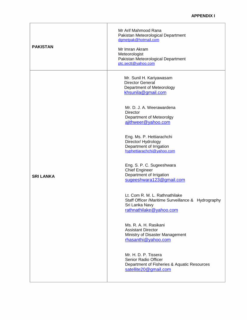
APPENDIX I
PAKISTAN
Mr Arif Mahmood Rana Pakistan Meteorological Department [email protected] Mr Imran Akram Meteorologist Pakistan Meteorological Department [email protected]
SRI LANKA
Mr. Sunil H. Kariyawasam Director General Department of Meteorology [email protected]
Mr. D. J. A. Weerawardena Director Department of Meteorolgy [email protected] Eng. Ms. P. Hettiarachchi Director/ Hydrology Department of Irrigation [email protected] Eng. S. P. C. Sugeeshwara Chief Engineer Department of Irrigation [email protected] Lt. Com R. M. L. Rathnathilake Staff Officer /Maritime Surveillance & Hydrography Sri Lanka Navy [email protected] Ms. R. A. H. Rasikani Assistant Director Ministry of Disaster Management [email protected] Mr. H. D. P. Tissera Senior Radio Officer Department of Fisheries & Aquatic Resources [email protected]

APPENDIX I
THAILAND
Mr Worapat Tiewthanom Director General Thai Meteorological Department [email protected] Mr Charoon Laohalertchai Director of Northern Meteorological Centre Thai Meteorological Department [email protected] Dr Wattana Kanbua Director of Marine Meteorological Center Marine Meteorological Center [email protected] Mr Pisit Bumpenkij Senior Professional Hydrologist Royal Irrigation Department [email protected] Mr Somkid Saphaokham Hydrologist Royal Irrigation Department [email protected] [email protected] Ms Supinda Wattanakarn Senior Hydrologist Professional Level Royal Irrigation Department [email protected]
OBSERVERS
CHINA
Mr Qian Chuanhai Director/Typhoon and Marine Weather Forecast Center China Meteorological Administration [email protected]
ESCAP/WMO TYPHOON COMMITTEE
Mr Olavo Rasquinho Secretary of the Typhoon Committee [email protected]
INTERNATIONAL ORGANIZATIONS
ICAO
Mr Peter Dunda Regional Officer ICAO, Asia and Pacific Office, Bangkok [email protected]

APPENDIX I
UNESCO/IOC
Mr Tony Elliot Head of ICG/IOTWS Secretariat [email protected]
CAS/WMO
DR. Duan Yihong President of Chinese Academy of Meteorological Sciences/ CMA [email protected]
SECRETARIAT
PTC SECRETARIAT
Mr Arif Mahmood Rana Director General Pakistan Meteorological Department [email protected] Mr Imran Akram Meteorologist Pakistan Meteorological Department [email protected]
WMO SECRETARIAT
Mr Koji Kuroiwa Chief Tropical Cyclone Programme Division/WMO [email protected] Dr Taoyong Peng Tropical Cyclone Programme Division [email protected]
ECONOMIC AND SOCIAL COMMISSION FOR ASIA AND THE PACIFIC (UN-ESCAP)
Mr Alf Blikberg Programme Officer/UN-ESCAP Disaster Risk Reduction Section of the ICT [email protected] Mr Michio Ito Officer/UN-ESCAP Disaster Risk Reduction Division [email protected]
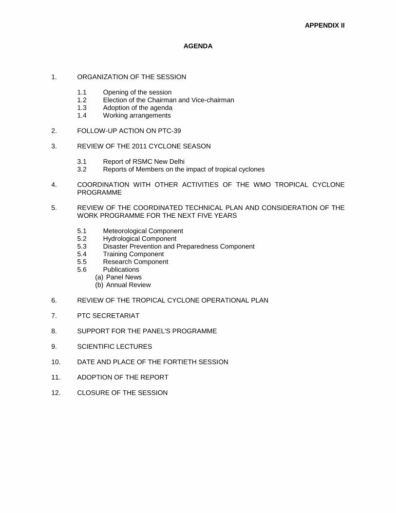
APPENDIX II
AGENDA
1. ORGANIZATION OF THE SESSION 1.1 Opening of the session 1.2 Election of the Chairman and Vice-chairman 1.3 Adoption of the agenda 1.4 Working arrangements 2. FOLLOW-UP ACTION ON PTC-39 3. REVIEW OF THE 2011 CYCLONE SEASON 3.1 Report of RSMC New Delhi 3.2 Reports of Members on the impact of tropical cyclones 4. COORDINATION WITH OTHER ACTIVITIES OF THE WMO TROPICAL CYCLONE
PROGRAMME 5. REVIEW OF THE COORDINATED TECHNICAL PLAN AND CONSIDERATION OF THE
WORK PROGRAMME FOR THE NEXT FIVE YEARS 5.1 Meteorological Component 5.2 Hydrological Component 5.3 Disaster Prevention and Preparedness Component 5.4 Training Component 5.5 Research Component 5.6 Publications
(a) Panel News (b) Annual Review
6. REVIEW OF THE TROPICAL CYCLONE OPERATIONAL PLAN 7. PTC SECRETARIAT 8. SUPPORT FOR THE PANEL'S PROGRAMME 9. SCIENTIFIC LECTURES 10. DATE AND PLACE OF THE FORTIETH SESSION 11. ADOPTION OF THE REPORT 12. CLOSURE OF THE SESSION

APPENDIX III
Action Sheet for the 39 th session of the Panel
Para. No. Subject Action Required Responsible Deadl ine Remarks
4.3 Update of the Global Guide to Tropical Cyclone Forecasting
The updated version of the Global Guide to be published, and linked to the “Tropical Cyclone Forecaster’s website”.
WMO (TCP) End of 2012 Ongoing
4.8 WMO Coastal Inundation Forecasting Demonstration Project (CIFDP)
To include in PTC’s Annual Operating Plan (AOP) an action to develop a collaborative linkage with CIFDP-B
Members MMoP
5.0.3 Coordinated Technical Plan (CTP)
Members were urged to give their suggestions and feedback on the content of the CTP for adoption of the CTP for the next four years 2012-2015.
Members
5.0.4 Development of the Annual Operating Plan (AOP) for 2012 for the five
develop the Annual Operating Plan (AOP) for 2012 for the five components to achieve the goals and objectives of the Coordinated Technical Plan (CTP)
Members
5.0.6 A workshop for a case study To organize it during 2012. PTC Working Group on Meteorology (WGM)
End of 2012 Done
5.0.7 Working Group on Hydrology To identify a focal point from each member country to develop the working group.
PTC Secretariat
5.0.8 Working Group on Disaster Prevention and Preparedness (WGDPP)
To set up online group and a mailing list. PTC Secretariat
5.1.2 Doppler weather radar in the Maldives Meteorological Service (MMS)
Request PTC and WMO to explore the possibility to assist MMS to find ways to calibrate the radar system
PTC and WMO
5.1.3 Upper Air Observation Network and Aeronautical Meteorological Services in Myanmar
To enhance Upper Air Observation Network and upgrade Aeronautical Meteorological Services in Myanmar.
WMO/ICAO
5.1.12 Common Alerting Protocol (CAP)
Consideration of early implementation of CAP in the Panel Members for their warning services
Members

APPENDIX III
Para. No. Subject Action Required Responsible Deadl ine Remarks
5.1.17 SWFDP-Bay of Bengal To design and develop it for its first demonstration period.
WMO As soon as possible.
DPFS
• Considers the establishment of a Working Group Hydrology (WGH) in analogy to the highly successful WGH of the ESCAP/WMO Typhoon Committee (TC) with active involvement of hydrologists and seeks to enhance full collaboration with the TC;
PTC/WMO/ESCAP
Done.
• Establishes closer links with the RA-II WGH on the working level and with individual experts;
PTC/WMO/ESCAP
• Develops a Requirements Document for hydrological services in support of current and planned PTC activities;
PTC/WMO/ESCAP
To be discussed in WGH.
• Makes use of services provided through CHy and the WMO Flood Forecasting Initiative in particular as well as proposals for new HYCOS components;
PTC/WMO/ESCAP
To be discussed in WGH.
• Further provides suggestions for activities to be carried out in support of PTC needs in hydrology;
PTC/WMO/ESCAP
To be discussed in WGH.
5.2.14 Recommendations for the PTC
• Makes use of the services provided by the APFM in the area of Integrated Flood Management
PTC/WMO/ESCAP
To be discussed in WGH.
5.4.7 The RSMC and IIT attachment trainings
To request the RSMC New Delhi and IIT to continue to host the training for the coming years.
WMO/PTC Secretariat
Done.
5.4.13 Competency approach To consider reviewing and adapting the competency approach being used by Tropical Cyclone Centres.
WMO To be discussed in WGM.

APPENDIX III
Para. No. Subject Action Required Responsible Deadl ine Remarks
5.6.1 PTC Newsletter • To provide their contributions in the form news material related to development activities, science news, training workshops, research reports etc. • To update information about Members’ News Correspondents.
Members.
5.6.3 On assessment of the impact of climate change on tropical cyclone activities in the PTC region.
To search for the knowledge and research papers on the impact of climate change on tropical cyclone activities available in their respective countries and updated feedback and research papers/reports on the issue may again be sent to the PTC secretariat during 2012.
To request RSMC, New Delhi for sending to the PTC Secretariat the outcomes of the Second International Conference on Indian Ocean Tropical Cyclones and Climate Change (New Delhi, India, 14-17 February 2012)
Members, PTC Secretariat RSMC, New Delhi
6.1 Amendments of the Operational Plan
To communicate the Members’ amendments, if any, to Mr. Bandayopadhyay
Members 31 March 2012 Done.
6.2 The list of focal points of the forecast centers.
To re-establish it PTC Secretariat
8.14 Trust Fund To enhance Members’ contributions to the Trust Fund
Members/WMO To be discussed at PTC-40.

APPENDIX IV
CYCLONIC ACTIVITIES OVER NORTH INDIAN OCEAN DURING 2012 The north Indian and adjoining land surface Ocean witnessed the formation of five cyclonic disturbances during the year 2012. Out of five disturbances three formed over the Bay of Bengal and two over the Arabian Sea. Out of the three cyclonic disturbances over the Bay of Bengal, one intensified upto the stage of cyclonic storm, NILAM, two upto the stage of deep depression. Out of two cyclonic disturbances formed over the Arabian Sea, one intensified upto the stage of cyclonic storm, MURJAN and one upto the stage of deep depression. Tracks of the cyclonic disturbances formed over the north Indian Ocean during the period are shown in Fig 2.1. The salient features of the cyclonic disturbances during 2012 were as follows: • The number of total cyclonic disturbances (depression and above) during the year was
significantly below normal, as only five cyclonic disturbances formed during 2012 against the normal of 13. Similarly only two cyclones formed during the year against the normal of about 5.
• Both the cyclones made landfall .While cyclone ‘MURJAN’ made landfall over Somalia, the cyclonic storm, ‘NILAM’ made landfall over Tamilnadu and Puducherry coast.
• The track of the cyclone ‘NILAM’ was rare in nature as it initially moved westwards, come closer to Srilanka coast and remained stationary for about a day and then moved north-northwestwards to cross Tamilnadu coast.
• There were no cyclonic disturbances formed over the north Indian Ocean and adjoining land surface during monsoon season (June-Sep.) against the normal of 7 cyclonic disturbances. There were no cyclonic disturbances over the north Indian Ocean during the pre-monsoon season (March-May), 2012 also.
(a) Cyclonic Storm, “MURJAN” over the Arabian Sea (23-26 October, 2012.)
The cyclonic storm, Murjan formed over the south Arabian Sea in association with an active inter tropical convergence zone during last week of October 2012. It was the first cyclone over the north Indian Ocean during this year. Moving west southwestwards, it crossed Somalia coast between 1700 and 1800 UTC of 25th October near lat. 9.80N and 50.80E. The salient features of this cyclone are given below. (i) It was the first cyclonic storm to hit Somalia after 1994. A severe cyclonic storm crossed
Somalia coast on 19th November 1994 near lat. 8.00N. (ii) The cyclonic storm, Murjan caused heavy rainfall and strong wind over Somalia and Ethiopia. (iii) Though predicted by most of the numerical weather prediction (NWP) models to gradually
weaken before landfall, it maintained its cyclonic storm intensity till landfall. (b) Cyclonic Storm, ‘NILAM’ over the Bay of Bengal (28 October- 1 November) A cyclonic storm, NILAM crossed Tamilnadu coast near Mahabalipuram (south of Chennai) in the evening of 31st October 2012 with a sustained maximum wind speed of 70-80 knots. The salient features of this storm are as follows. (i) It followed a unique track with many rapid changes in direction of movement. It initially moved
westwards, remained practically stationary for quite some time near Sri Lanka coast and then moved north-northwestwards till landfall. It moved west-northwestwards initially over land upto south interior Karnataka and then moved northwest and northwards. The remnant low pressure area moved northeastwards
(ii) It moved very faster on the day of landfall, i.e. 31st October 2012. (iii) Over the land surface, the cloud mass was significantly sheared to the northeast of system
centre during its dissipation stage leading to rainfall activity over entire Andhra Pradesh and adjoining Odisha

APPENDIX IV
(iv) Maximum rainfall occurred over southwest sector of the system centre and heavy to very heavy rainfall extended upto 300 km.
The statistics of the cyclonic disturbances formed during 2012 are given in Table 2.1. The characteristic features of these disturbances are given in Table 2.2. The intraseasonal variation in frequency of genesis, intensification and life period of the disturbances is shown in Table 2.3.
Table 2.1: Cyclonic disturbances formed over north Indian Ocean and adjoining land areas
during 2012
1. Deep Depression over Bay of Bengal 10-11 October 2012
2. Cyclonic storm ‘MURJAN’ over Arabian Sea 23-26 October 2012
3. Cyclonic storm ‘NILAM’ over Bay of Bengal 28 October- 1 November 2012
4. Deep Depression over Bay of Bengal 17-19 November 2012
5 Deep Depression over Arabian sea 22-25 December 2012
Table 2.2: Some Characteristic features of cyclonic disturbances formed over north Indian Ocean and adjoining region during 2012
Cyclonic Storm / Depression
Date, Time & Place of genesis (Lat.0N/ Long.0E)
Date, Time (UTC) place (Lat./Long.) of landfall
Estimated lowest central pressure, Time & Date (UTC) & latoN / longoE
Estimated Maximum wind speed (kt), Date & Time
Max. T.No. Attained
Deep Depression over the Bay of Bengal 10-11 October 2012
10 October 2012 at 1200 UTC over northeast Bay of Bengal near 21.0/91.0
Crossed Bangladesh coast near Hatia between 0000-0100 UTC of 11 October 2012
1002 hPa at 1800 UTC of 10 October 2012 near 22.0/91.0
30 knots at 1800 UTC of 10 October 2012
T-2.0
Cyclonic Storm ‘MURJAN’ over Arabian Sea (23-26 October 2012)
23 October 2012 over southeast Arabian Sea near 11.0/65.0
Crossed Somalia coast near latitude 9.50N/longitude 50.80E) between 1700-1800 UTC of 25 October 2012
1000 hPa at 1200 UTC of 24 October 2012 near 10.5/56.5
40 Knots at 1800 UTC of 24 October 2012
T-2.5
Cyclonic Storm ‘NILAM’ over Bay of Bengal (28 October- 1 November 2012)
28 October at 0600 UTC over southeast Bay of Bengal near 9.5/86.0
Crossed Tamil Nadu coast Near Mahabalipuram (near latitude 12.60N/longitude 80.20E) between 1600-1700 UTC of 31 October 2012
990 hPa at 0000 UTC of 31 October 2012 near 10.5/811.5
45 knots at 0000 UTC of 31 October 2012
T-3.0
Deep Depression over the Bay of Bengal (17-19 November 2012)
17 November 2012 at 0600 UTC near 15.5/90.0
Weakened into a Well Marked Low Pressure area over west central Bay of Bengal at 1500 UTC of 19 November 2012
1002 hPa at 1200 UTC of 17 November 2012 near 16.0/89.0
30 Knots at 1200 UTC of 17 November 2012
T-2.0
Deep Depression over Arabian sea (22-25 December 2012)
22 December 2012 at 0900 UTC near 9.0/63.0
Weakened into a Well Marked Low Pressure area over southwest Arabian sea off Somalia coast
1002 hPa at 0000 UTC of 23 december 2012 near 9.0/60.5
30 knots at 0000 UTC of 23 December 20112
T-2.0

APPENDIX IV
Table 2.3: Statistical data relating to cyclonic di sturbances over the north Indian Ocean during 2012
A) Monthly frequencies of cyclonic disturbances (CI ( 1.5)
S.N Type Jan Feb Mar Apr May Jun Jul Aug Sep Oct Nov Dec
1. D
2. DD ( ( ↔↔↔↔
3. CS ↔↔↔↔
↔↔↔↔
↔↔↔↔ Peak intensity of the system B) Life time of cyclonic disturbances during 2012 at d ifferent stages of intensity
S. No. Type Life Time in (Days)
1. D 5.2 2. DD 5.9 3. CS 2.9 4. SCS 0 5. VSCS 0
6. SuCS 0
Total Life Time in (Days) 14.0
C) Frequency distribution of cyclonic disturbances with different intensities based on
satellite assessment
CI No.
(1.5 (2.0 (2.5 (3.0 (3.5 (4.0 (4.5
(5.0
No. of disturbances 5 5 2 1 0 0 0 0
D) Basin-wise distribution of cyclonic disturbances
Basin Number of cyclonic disturbances
Bay of Bengal 3 Arabian Sea 2
Land depression 0
Table 2.4. Cyclonic disturbances formed over the no rth Indian Ocean and land areas of India during 1997-2012
Year Basin D DD CS SCS VSCS
SuCS
Total
BOB 1 4 1 1 1 0 8
ARB 1 0 0 0 0 0 1
Land 0 0 0 0 0 0 0 1997
Total 9 BOB 0 3 0 1 2 0 6 ARB 0 1 1 1 1 0 4
1998
Land 1 0 0 0 0 0 1

APPENDIX IV
Total 11 BOB 2 2 1 0 1 1 7
ARB 0 0 0 0 1 0 1
Land 1 0 0 0 0 0 1 1999
Total 9 BOB 1 1 2 -- 2 0 6
ARB 0 0 0 0 0 0 0
Land 1 0 0 0 0 0 1 2000
Total 7 BOB 2 0 1 0 0 0 3
ARB 0 0 2 0 1 0 3 Land 0 0 0 0 0 0 0
2001
Total 6 BOB 1 1 2 1 0 0 5
ARB 0 0 0 0 0 0 1 Land 0 0 0 0 0 0 0
2002
Total 6 BOB 2 2 0 1 1 0 6
ARB 0 0 0 1 0 0 1 Land 0 0 0 0 0 0 0
2003
Total 7 BOB 2 0 0 0 1 0 3
ARB 0 2 0 3 0 0 5
LAND 2 0 0 0 0 0 2 2004
Total 10 BOB 2 3 4 0 0 0 9
ARB 2 0 0 0 0 0 2
LAND 1 0 0 0 0 0 1 2005
Total 12 BOB 5 2 1 0 1 0 9
ARB 0 1 0 1 0 0 2
LAND 1 0 0 0 0 0 1 2006
Total 12 BOB 3 4 1 0 1 0 9
ARB 0 1 1 0 0 1 3
Land 0 0 0 0 0 0 0 2007
Total 12
BOB 1 2 3 0 1 0 7
ARB 1 1 0 0 0 0 2
LAND 1 0 0 0 0 0 1 2008
Total 10
BOB 0 2 2 1 0 0 5
ARB 2 0 1 0 0 0 3
LAND 0 0 0 0 0 0 0 2009
Total 8 BOB 2 1 0 2 1 0 6
ARB 0 0- 1 0 1 0 2
LAND 0 0 0 0 0 0 0 2010
Total 8

APPENDIX IV
BOB 2 2 0 0 1 0 5
ARB 1 2 1 0 0 4
LAND 1 0 0 0 0 0 1 2011
Total 10 BOB 0 2 1 0 0 0 3
ARB 0 1 1 0 0 0 2
LAND 0 0 0 0 0 0 0 2012
Total 5 D: Depression DD: Deep Depression, CS: Cyclonic Storm, SCS: Severe Cyclonic Storm, VSCS: Very Severe Cyclonic Storm, SuCS: super Cyclonic Storm BOB: Bay of Bengal, ARB: Arabian Sea
Fig. 2.1 Tracks of the cyclonic disturbances formed over the north Indian Ocean during the year, 2012

APPENDIX V
Country Report of the Members – Bangladesh Meteorological Component Bangladesh Meteorological Department is in the process of strengthening of its observational
network:
• Itroduction of advanced technology for observational systems with induction of automatic weather station (AWS). • BMD has installed Two Doppler Weather Radar at Cox’s Bazar & Khepupara for Tropical Cyclone monitoring. • BMD has installed one Doppler Weather Radar at Mowlvi Bazar, North-eastern part of Bangladesh for flash flood warning. • There are another two Weather Radar at Dhaka and Rangpur for monitoring severe local thunder storm. • 24 AWS will be installed under SAARC STORM programme at different places for Nor’westers.
Upper Air Observation
• GPS based Radiosode-3
Forecast System
• WRF, JMA- NHM model, IIT-NewDelhi Storm surge model, MRI model • Installation of Diana by Met Norway
Outcomes of the program: • Improved Forecast Services • Now casting of severe weather events • Increased accuracy of short and medium range forecast • Multi hazard early warning • Real Time Data Availability • Spatial & Temporal Coverage • Better Service Delivery
Hydrological Component
Bangladesh Meteorological Department (BMD) is providing the necessary technical and operational support, weather forecast, Rainfall data, Doppler Weather Radar observations to Flood Forecasting & Warning Center of Bangladesh Water Development Board. Flood Meteorological unit of Bangladesh Meteorological Department (BMD) provides input to FF&WC of Bangladesh.
Disaster Prevention and Preparedness (DPP)
Bangladesh Meteorological Department (BMD) is the authoritative organization in the country for issuing advisories and warnings related to Meteorological, Hydrological, and earthquake information, Tropical Cyclones, Storm Surges and Coastal Inundation etc. All Government Organizations, Department of Disaster Management, NGO’s, Public and Print Media receive advisories and warnings from Bangladesh Meteorological Department. A Disaster Management Law has been enacted in Bangladesh from 2012 with a view to creating the legislative tool under which disaster risks and emergency management actions are being undertaken in Bangladesh and providing the legal basis under which activities and actions are identified, undertaken and managed.

APPENDIX V
TRAINING COMPONENT
• To build capacity in NWP, weather forecasters of Bangladesh Meteorological
Department were trained in a project “Human capacity on operational weather analysis”- supported by JICA. A pc cluster has been installed in the Storm Warning Center of BMD for training on NWP under JICA project. JMA-NHM model has been installed in the Storm Warning Center (SWC) of BMD.
• A training program was held from 21-28 Nov. 2012 in Bangladesh Meteorological
Department, Dhaka under the project “Institutional support and capacity building for mitigation of weather and climate hazards in Bangladesh”. The project is supported by Norwegian Meteorological Institute. Diana was installed in the National Weather Forecasting Centre of Bangladesh Meteorological Department (BMD). Meteorologist of Bangladesh Meteorological Department received hands on training on the use of Diana as a tool for weather forecasting conducted by the Operational Forecaster/Meteorologist of Norwegian Meteorological Institute. Climatologist of BMD also received a hands on training on the analysis of Climate data by using R- Software
Research/Publications
Research studies have been carried out in the following topics by the members of the Department-
� Analysis of extreme rainfall events � Analysis of Tropical cyclone “NILAM”. � Analysis of significant Nor‘wester events. � BMD provides information on significant weather and new developments related to
meteorology through BMD’s newsletters

APPENDIX V
Country Report of the Members – India
3. A REVIEW OF THE 2012 CYCLONE SEASON 3.1 Report of RSMC- Tropical cyclone, New Delhi A report on cyclonic disturbances over the north Indian Ocean during the year 2012 has been published by RSMC, New Delhi. However an overall review based on seasonal summary is given in Appendix-I. Behaviors of individual cyclones and forecast performance of RSMC, New Delhi have been presented in the technical report published by RSMC, New Delhi. 4. COORDINATION WITH OTHER ACTIVITIES OF THE WMO TROPICAL CYCLONE PROGRAMME Appendix-II gives the respective sources for obtaining the action taken report. 5. Review of coordinated technical plan and consideration of the work programme for the next five years (2012-2016) 5.1 Meteorology A brief description of different types of observational network of IMD and observations collected from networks are given below: a. Surface Observatories The network of surface meteorological observatories consists of total 709 Stations. The break-up of various categories is as follows: CATEGORY OF DEPARTMENTAL OBSERVATORIES
CLASS RMC Delhi
RMC Chennai
RMC Kolkata
RMC Mumbai
RMC Nagpur
RMC Guwahati
Total
I , II (a), IV, VI & SMO (Deptt.)
57 53 31 29 17 17 204
II (b), II (c), II (d), III & IV, V, VI Io & EMO (Non Deptt.)
106 71 47 30 47 25 326
V (Non Deptt. HMO)
64 17 54 21 12 11 179
TOTAL 227 141 132 80 76 53 709
AIRPORT METEOROLOGICAL INSTRUMENTS There are seventy airports where meteorological instruments have been provided. The international and national airports are equipped with additional instruments such as: 1) Laser Ceilometers 2) Transmissometer

APPENDIX V
3) Current Weather Instrument System 4) Distant Indicating Wind Equipment At present, CWIS at all airports is working satisfactorily. Performance of DIWEs has been more or less satisfactory during the year. Integrated Automatic Aviation Meteorology System (IAAMS) are functional at Mumbai, New Delhi, Jaipur, Hyderabad, Bangalore, Chennai, Guwahati and Amritsar. High Wind Speed Recorders (HWSRs) HWSR system has been installed and operational at 13 coastal stations. These are Digha, Visakhapatnam, Chennai, Nellore, Machilipatnam, Karaikal, Puri, Balasore, Gopalpur, Paradip, Mumbai (Colaba), Veraval & Dwarka. These are not functional at Puri, Balasore & Veraval. All HWSR stations are being equipped with GPRS modems so that the data in real time is available at website “imdaws.com”. AWS Network Under the modernization Phase - I, a TDMA earth station along with 550 AWS has been installed. Data from AWS sites are being received at Pune Receiving Earth Station. From Pune Receiving Earth Station, hourly data is being sent to AMSS Mumbai through dedicated lease line for onward transmission through GTS to different users. Quality of AWS data from new AWS stations is under evaluation. Under the project 1350 ARGs, 955 ARGs have been installed. Recent Achievements
1. Completion of installation of 550 AWS Project in February 2012. 2. Augmentation of surface ozone network: Installation of Surface Ozone Instruments at 10
stations. 3. Comparison of AWS data received through Kalpana – 1 Satellite with Co- located obsy.
data is in progress. 4. Installation of sky radiometers at 13 stations. 5. GPRS based modules interfaced with Sutron data logger at 15 radiation stations to facilitate
transmission of the data on the website. Thus real time data can be accessed at any location on the website.
Future Plan 12th Five Year Plan (2012-2017) 1. Projects under AOSN
I. Commissioning of TDMA type receiving Earth Station at IMD Pune II. Commissioning of 50 Lightning Detection Sensors III. Commissioning of 50 ship based Automatic Weather Stations IV. Augmentation of Radiation Network. V. Procurement of Digital Station Barometers (500Nos.).
VI. Procurement of spares for maintenance of Radiation network stations

APPENDIX V
VII. Up-gradation of the manufacturing facility for Surface Meteorological Instruments at IMD Work Shop- Procurement of Induction Furnace, Powder Coating machine and CNC Machine
VIII. Procurement and installation of Fire Alarm system in AWS Building 2. Projects under Weather Services – Aviation Airport Meteorological Instruments (AMI)
I. Commissioning of Automatic Weather Observing System (AWOS) at -46 airports. II. Commissioning of AWOS at 20 new airports. III. Commissioning of Automatic Weather Observing System for safety of helicopter
operations at 20 heliports. IV. Procurement of spares for in house maintenance of AMIs, such as Current Weather
Instrument System, ceilometers and Transmissometers. V. Commissioning of 10 additional transmisometers for the airports
b. Upper Air observatories (A) RADAR Network Originally India Meteorological Department was maintaining a network of 39 RADARs. Based on their usage, they are categorized as Storm Detection and Cyclone detection RADARs. Cyclone Detection radars located along the east and west coast operate in S-band and storm detection radars located all over the country operate in X-band frequency range. Optimum network requirements - 55 Doppler Weather Radars. (a) Cyclone Detection Radars (CDRs) :- Present Status: Prior to Mod. Phase-I – 5 Nos S-Band Doppler Weather Radars and under Mod. Phase-I & Ongoing - 12 S-Band (METSTAR), 2C-Band (Vaisala) & 2 S-Band(BEL). 1. KOCHI CDR Station BEL 2. BHUJ CDR Station BEL India 3. KARAIKAL CDR Station S-Band 4. PARADEEP CDR Station S-Band 5. MUMBAI Doppler Weather Radar BEL 6. CHENNAI Doppler Weather Radar Germany 7. KOLKATA Doppler Weather Radar Germany 8. MACHILIPATNAM Doppler Weather Radar Germany 9. VISAKHAPATNAM Doppler Weather Radar Germany 10. SHAR Doppler Weather Radar ISRO India 11. HYDERABAD Doppler Weather Radar MetStar China 12. LUCKNOW Doppler Weather Radar MetStar China 13. MOHANBARI Doppler Weather Radar MetStar China 14. NAGPUR Doppler Weather Radar MetStar China 15. PALAM Doppler Weather Radar MetStar China 16. PATIALA Doppler Weather Radar MetStar China 17. PATNA Doppler Weather Radar MetStar China

APPENDIX V
18. AGARTALA Doppler Weather Radar MetStar China 19. HQ NEWDELHI Doppler Weather Radar VAISALA 20. JAIPUR Doppler Weather Radar VAISALA
(i) Procurement of 2 Nos. of DWRs from M/s BEL Bangalore IMD is in the process of procuring two nos. of DWRs from M/s BEL, Bangalore under an ongoing scheme for replacement of existing radars at Bhuj and Kochi. The radar meant for Kochi has been installed at Mumbai due to some technical reasons. The RADAR is under installation at Bhuj. (ii) Commissioning of 12 Nos. of DWRs: In first Phase of modernization plan of IMD, 12 Nos DWRs procured from M/s Beijing Metstar, China are installed at Delhi (Palam), Hyderabad, Patna, Mohanbari, Patiala and Lucknow, and are yet to be installed at Bhopal, Goa, Paradip, and Karaikal. (iii) Procurement of 2 C-band DWRs:- IMD has procured 2 C-band dual polarized DWRs for installation in the IMD's radar network. These C-band DWR are installed at Delhi (HQ), Mausam Bhawan and at M.C Jaipur and commissioned. (b) Storm Detection Radars (SDRs):- NAGPUR Weather Radar BEL DELHI Weather Radar S-Band JAISALMER Weather Radar S-Band SRIGANGANAGAR Weather Radar S-Band LUCKNOW Weather Radar X-Band BEL MUMBAI Weather Radar X-Band BEL CHENNAI Weather Radar X-Band EEC GUWAHATI Weather Radar X-Band EEC KOLKATA Weather Radar X-Band EEC RANCHI Weather Radar X-Band EEC (c.) Wind Finding Radars:- KARAIKAL Wind Finding Radar BEL India MACHILIPATNAM Wind Finding Radar BEL India THIRUVANANTHAPURAM Wind Finding Radar BEL India GOA Wind Finding Radar EEC (d.) Weather cum Wind Finding Radars:- CHENNAI Weather & Wind Finding Radar BEL DELHI Weather & Wind Finding Radar BEL HYDERABAD Weather & Wind Finding Radar BEL PATIALA Weather & Wind Finding Radar BEL AHMEDABAD Weather & Wind Finding Radar EEC BANGALORE Weather & Wind Finding Radar EEC BHUBANESWAR Weather & Wind Finding Radar EEC MANGALORE Weather & Wind Finding Radar EEC VISAKHAPATNAM Weather & Wind Finding Radar EEC Under modernization, on-going schemes, their present status and future plans are as follows:-

APPENDIX V
On-going schemes and their present status
� Installation of the 10 GPS systems. Present proposal is for installation at the 10 locations where MODEM GPS were installed namely TRV, PBL, MBR, Goa, VSK, PTN, Chennai, SRN, MNC & HYD.
� Induction of other advanced measurement techniques in the observational network. � Plan is to install Wind Profilers, Wind Lidars, Microwave Radiometer and GPS based Pilot
Balloon Systems. � As per the recommendations of the NWP division it has been decided to install one of
each system at Delhi, Chennai, Nagpur, Kolkata and Mumbai airports in the pilot phase. � For further augmentation of DWR network, a committee has been constituted by
Secretary, MoES, to decide radar network in 2nd phase of modernization. � For calibration/validation a Disdrometer with each DWR (SRRG and ARG available near or
around 100 Km radius of DWR site) is planned in 2nd phase. � Commissioning of 34 Nos. or more S/C band Polarimetric DWRs through global tendering
in 2nd Phase of Modernization during 12th Five Year Plan is under process of approval. � A committee is constituted to work out and recommend the detailed requirements for
radars, data mosaicing, archival/storage system for seamless on line data dissemination to all its end users .
Future Plans : (a) Modernisation phase II & Phase III :-
On completion of the modernization phase I, IMD will have 21 DWRs in its observational network. In the II and III phase of modernization, 34 more DWRs will be procured and inducted in the total radar network of 55 DWRs to bring entire country under radar coverage. Locations for 20 DWR installations have already been identified. The program of installation of 20 out of 34 DWRs is expected to be completed by December, 2014. (b) Establishment of National Weather Radar Operation Centre (NWROC) at New Delhi (HQ) Action for setting up National Weather Radar Operation Centre (NWROC) has already been initiated. The committee constituted by DGM to give recommendations for establishment of NWROC has submitted its report. Detailed project report has also been submitted. EFC for the establishment of NWROC has also been prepared .The scheme has been included in the IInd phase of modernization under networking of radars. (c) Establishment of National Radar Data Centre (ENRDC) at New Delhi (HQ):- Action for setting up National Radar Data Centre (ENRDC) has already been initiated. The committee is being constituted for the same. (B) Status of Upper Air Instrument Network: At present, ascents with GPS Radiosonde are taken at Chennai, Srinagar & Hyderabad. IMD stations collocated with Indian Navy/IAF at 7 stations Nal, Aadampur, Kumbhigram, Arakkonam, Goa, Visakhapatnam & Kochi will transmit the observation taken from Indian Navy/IAF. Attempts are being made to start the manufacturing the Mark-IV radiosonde using solid state pressure sensor. Out of 39 RS/RW stations, priority “A” stations will take one ascent.

APPENDIX V
A scheme is proposed to improve the quality of observations at all 39 RS/RW stations under Modernization of IMD phase -1. To provide the data from high quality radiosonde, 25 RS/RW stations of the network will be operating with the GPS radiosondes procured through global tender.
� GPS based radio sounding system installed at Ahmedabad, Bhubaneswar, Bhopal, Kolkata and Nagpur.
� GPS radiosonde for Delhi has been obtained from IITM on loan basis � Supply order placed for manufacturing of 4000 nos. of Indigenous GPS based radio
sounding systems. Supply not yet received. � Supply order placed for 8000 GPS sondes with 10 numbers of ground systems. The items
will be received by end of February 2013. The Global Climate Observing System (GCOS) Upper-Air Network (GUAN) is a subset of the global radiosonde network and comprises about 170 stations worldwide, to establish national commitments for the preservation of a minimum set of upper-air stations. At present, no Indian upper air station is part of GUAN and 6 RMCs namely New Delhi, Kolkata, Mumbai, Chennai, Guwahati & Nagpur are proposed to be part of GUAN. The induction of Indigenous GPS radiosonde will be done in a phased manner. Indigenously developed radiosonde will be introduced at 14 stations in the first year for the extensive trial. Radiosonde will be manufactured in the workshop after procuring the required sensors package, GPS module, PCBs, Battery & housing. Radio receivers to decode the data from these radiosonde will be manufactured under MoU with M/s SAMEER or ISRO. Manufacturing facilities of IMD at Agra and New Delhi will be up graded as per ISO standards. Even though, there is no replacement for the radiosonde measurement but various remote sensing instruments like wind profilers & Lidars have been introduced as alternatives to Pilot balloon observation in the global network to supplement high temporal resolution data suitable for NWP models. Another system named Microwave radiometer is also introduced to calculate a variety of surface and atmospheric parameters. These systems can operate unattended 24 hrs and in nearly all weather conditions and also capable of providing data nearly in all weather conditions. c) Meteorological Satellite Present status: Met. Satellites of special relevance to TC analysis over North Indian Ocean are: INSAT and Kalpana Oceansat-II DMSP NOAA METEOSAT METOPs MODIS Payload from AQUA/TERRA. TRMM All processed, VHRR/CCD images are analyzed and advisories based on the imageries and derived products are provided to main forecasting centre of IMD. Normally 3-hourly satellite bulletins are prepared and sent on GTS for use of everyone. In case of severe weather, special satellite bulletins are issued. During the occurrence of tropical cyclones, the cyclone center, and intensity are determind using Dvorak Technique every hour and communicated to the main forecasting centres of IMD and are also disseminated to other Met. Offices. Efforts are on to use Objective Dvorak Technique provided by SAC,ISRO in future cyclones. Future plans:

APPENDIX V
1. INSAT-3D: INSAT-3D Satellite Scheduled to be launched in 2013. Payloads a. It has a 6-channel Imager almost similar to GOES satellites of USA . b. It has a 19 –channel Sounder similar to GOES satellites. c. It has a Data Relay Transponder (DRT) similar to Kalpana-1 and INSAT-3A. INSAT-3D being an advanced satellite has better resolution and hence more accurate in monitoring weather and generating all other products and its vertical profile of temperature and humidity will make a great impact on weather forecasting by conventional and NWP methods and similarly on other applications. It will be possible to detect night time fog more frequently and its hydro- estimator will be a better estimate of rainfall for flood monitoring etc. 2. Megha-Tropiques mission of ISRO: Polar orbiting: It has the following payloads:
a) Microwave Analysis and Detection of Rain and Atmospheric Structures (MADRAS), with five channels of microwave for estimation of atmospheric water parameters in the equatorial belt. b) SAPHIR microwave humidity sounder and radiometer of 6 channels for humidity profile. c) SCARAB-broadband radiation measurement for measurement of Radiation fluxes.
Megha-tropique will give surface wind speed and convective rains over oceans and will be used in weather forecasting. Vertical profile derived from Radio occultation will be used in NWP models. 3. Planning to determine Central Pressure, Maximum Sustained Wind of Tropical systems using Brightness Temperatures like other countries. 4. Direct access of Meteosat-7 data & products. (d) Prediction Models in operational use during the year 2012 NWP Division of India Meteorological Department (IMD) operationally runs three regional models WRF (ARW), WRF (NMM) and Quasi-Lagrangian Model (QLM) for short-range prediction and one Global model (GFS T574/L64) for medium range prediction (7 days). The WRF-VAR model is run at the horizontal resolution of 27 km and 9 km with 38 Eta levels in the vertical and the integration is carried up to 72 hours over three domains covering the area between lat. 25o S to 45o N long 40o E to 120o E. Initial and boundary conditions are obtained from the IMD Global Forecast System (IMD GFS) at the resolution of 25 km. The boundary conditions are updated at every six hours interval. The QLM model (resolution 40 km) is used for cyclone track prediction in case of cyclone situation in the north Indian Ocean. IMD also makes use of NWP products prepared by some other operational NWP Centres like, ECMWF (European Centre for Medium Range Weather Forecasting), GFS (NCEP), JMA (Japan Meteorological Agency), UKMO etc. A multimodel ensemble (MME) for predicting the track of tropical cyclones for the Indian Seas is developed. The MME is developed applying multiple linear regression technique using the member models WRF, QLM, GFS (NCEP), ECMWF and JMA. NWP division also provides six hourly intensity forecasts and genesis potential inputs during cyclone conditions. Recently, Hurricane WRF (HWRF) and TC Ensemble Forecast products are also added for improving cyclone forecast service of IMD. Models in the experimental mode

APPENDIX V
Operational NWP Support for Cyclone Warning Service Following Numerical Weather Prediction Models are used for monitoring and prediction of tropical cyclones over north Indian Ocean: Global Models:
1. IMD GFS (T-574) 2. National Centre for Environmental Prediction (NCEP) GFS Model 3. European Centre for Medium-Range Weather Forecasts (ECMWF) Model 4. Japan Meteorological Agency (JMA) Model 5. Meteo France ARPEGE Model 6. UK Met Office (UKMO) Model
Regional models:
1. Quasi-Lagrangian Model (QLM) 2. Weather Research Forecast (WRF) IMD 3. Hurricane Weather Research & Forecast Model (HWRF)
Ensemble Systems:
1. Multi Model Ensemble Prediction Model (MME) 2. Single Model Ensemble Prediction System including:
• Global Ensemble Forecast System Model (GEFS) • European Centre for Medium-Range Weather Forecasts (ECMWF) Model • UK Met Office (UKMO) Model • Japan Meteorological Agency (JMA) Model • MCH Canada
The following initiatives implemented at IMD during 2012 India Meteorological Department operationally runs three regional models WRF (ARW), WRF (NMM) and Quasi-Lagrangian Model (QLM) for short-range prediction and one Global model (T382L64) (current version T574) for medium range prediction (7 days). The WRF-VAR model is run at the horizontal resolution of 27 km and 9 km with 38 Eta levels in the vertical and the integration is carried up to 72 hours over three domains covering the area between lat. 25o S to 45o N long 40o E to 120o E. Initial and boundary conditions are obtained from the IMD Global Forecast System (IMD GFS) at the resolution of 35 km. The boundary conditions are updated at every six hours interval. The QLM model (resolution 40 km) is used for cyclone track prediction in case of cyclone situation in the north Indian Ocean. IMD also makes use of NWP products prepared by some other operational NWP Centres like, ECMWF (European Centre for Medium Range Weather Forecasting), GFS (NCEP), JMA (Japan Meteorological Agency), UKMO etc. A multimodal ensemble (MME) for predicting the track of tropical cyclones for the Indian Seas is developed. The MME is developed applying multiple linear regression technique using the member models WRF, QLM, GFS (NCEP), ECMWF and JMA. NWP division also provides six hourly intensity forecasts and genesis potential inputs during cyclone conditions. Cyclone track prediction skill of these models are summarized here in Tabular form in the verification section. Hurricane WRF for Indian Seas The basic version of the model HWRFV (3.2+) which was operational at EMC, NCEP was ported on IBM P-6/575 machine, IMD, New Delhi with nested domain of 27 km and 9 km horizontal

APPENDIX V
resolution and 42 vertical levels with outer domain covering the area of 800x800 and inner domain 60x60 with centre of the system adjusted to the centre of the observed cyclonic storm. The model has special features such as vortex initialization, coupled with Ocean model to take into account the changes in SST during the model integration, tracker and diagnostic software to provide the graphic and text information on track and intensity prediction for real-time operational requirement. HWRF model was tested to run the model in cycling mode at IMD, New Delhi. In this run only the atmospheric model (HWRF) was tested. The Ocean Model (POM-TC) and Ocean coupler requires the customization of Ocean Model for Indian Seas. IMD is expecting to implement the Ocean cupping in collaboration with INCOIS, Hyderabad. The model is presently under testing for experimental operational implementation. HWRF forecast of maximum wind, track, intensity of maximum wind and Pmin. during cyclonic storm NILAM are shown in Fig. 3.
Fig.3 HWRF forecast of maximum wind, track, intensity of max. wind and Pmin.
TC Ensemble Forecast for Indian Sea As per the advice from WMO to provide a guidance of tropical cyclone forecasts in near real-time for the ESCAP/WMO members based on the TIGGE Cyclone XML (CXML) data, under the joint project of World Weather Research Program (WWRP) and Tropical Cyclone Program (TCP). TC homepage was developed by JMA and the same software was transferred to IMD to generate similar page for RSMC, New Delhi. The software was implemented at NWP Division, IMD, New Delhi and ensemble TC products from ECMWF, UKMO, NCEP and JMA will be provided experimentally during the post-monsoon cyclone season 2011 for ESCAP/WMO members of RSMC, New Delhi region. Products as per TIGGE ensemble run during CS NILAM based on 0000 UTC of 31st Oct. 2012 are shown in Fig.4.

APPENDIX V
Fig.4 Deterministic and probabilistic track and strike probability during Cyclonic storm NILAM as per TIGGE ensemble run based on 0000 UTC of 31st Oct. 2012 c) Implementation of Global Forecast System (GFS) Global Forecast System (GFS, based on NCEP) at T574L64 resolution has been implemented at NHAC, IMD HQ on IBM based High Power Computing Systems (HPCS). In horizontal, it resolves 574 waves (≈ 25 Km in the tropics) in spectral triangular truncation representation (T574). The model has 64 vertical levels (hybrid; sigma and pressure). This new higher resolution global forecast model and the corresponding assimilation system are adopted from NCEP, USA. The horizontal representation of model variables are in spectral form (spherical harmonic basis functions) with transformation to a Gaussian grid for calculation of nonlinear quantities and physics. In the operational mode, the Global Data Assimilation (GDAS) cycle runs 4 times a day (00 UTC, 06 UTC, 12 UTC and 18 UTC). The assimilation system for GFS T574 is a global 3-dimensional variation technique, based on NCEP Grid Point Statistical Interpolation (GSI 3.0.0; Kleist et al

APPENDIX V
2009) scheme, which is the next generation of Spectral Statistical Interpolation (SSI). The major changes incorporated in T574 GDAS compared to T382 GDAS are: use of variational quality control, flow dependent re-weighting of back ground statistics, use of new version and coefficient for community radiative transfer model, improved tropical cyclone relocation algorithm, changes in the land, snow and ice skill temperature and use of some new observations in the assimilation cycle. The data presently being pre-processed for Global Forecast System at IMD are Upper air sounding – TEMP, GPS & PILOT, Land surface – SYNOP, SYNOP MOBIL & AWS, Marine surface – SHIP, Drifting buoy – BUOY, Sub-surface buoy – BATHY, Aircraft observations - AIREP & AMDAR, Automated Aircraft Observation - BUFR (ACARS), Airport Weather Observations – METAR, Satellite winds – SATOB, High density satellite winds - BUFR (EUMETSAT & Japan), Wind profiler observations - BUFR (US/Europe), Surface pressure Analysis - PAOB (Australia), Radiance (AMSU-A, AMSU-B, HIRS-3 and HIRS-4, MSU, IASI, SSMI, AIRS, AMSRE, GOES, MHS, GPS Radio occultation, Rain Rate (SSMI and TRMM) Meso-Scale Assimilation System (WRF-VAR) The regional mesoscale analysis system WRF (ARW) was implemented on the HPCS at HQ of IMD, Delhi with its all components namely, pre-processing programs (WPS and REAL), data assimilation program (WRF-Var), boundary condition updating and forecasting model (WRF) and NCL for display. The pre-processed observational data from GTS and other sources prepared for the Global Forecast System in the BURF format (PREPBUFR of step 2 in GFS) is also used in case of WRF assimilation. In the WRF-Var assimilation system, all conventional observations over a domain (200S to 450N; 400E to 1150E) which merely cover Regional Specialized Meteorological Centre (RSMC), Delhi region are considered to improve the first guess of GFS analysis. Assimilation is done with 27 km horizontal resolution and 38 vertical eta levels. The boundary conditions from GFS forecasts run at IMD are updated to get a consistency with improved mesoscale analysis. WRF model is then integrated for 75 hours with a nested configuration (27 km mother and 9 km child domain) with physics including cloud microphysics, cumulus, planetary boundary layer and surface layer parameterization. The post-processing programs ARW post and WPP are also installed on HPCS to generate graphical plots and grib2 out for MFI-SYNERGIE system respectively. WRF at 3 km resolution was implemented for National Capital Region of Delhi Region. High resolution WRF has been in operational at other ten regional centres. (d) Telecommunication Network in IMD Present Status of Circuits in the GTS connected with RTH, New Delhi 1. India Meteorological Department has its National Meteorological Telecommunication Centre (NMTC) with an Automatic Message Switching computer System (AMSS) which is connected to WMO Centers on the GTS. The existing RTH switching system “TRANSMET” is the state-of-the-art technology system. It consists of two Separate Automatic Message Switching System (AMSS) for National and International data exchange. Each AMSS works in hot standby mode for 100% redundancy in case of any failure. During the period 2012-2013 following new data sets were received from different circuit and submitted on GTS
(i) BUFR data from Pakistan (ii) Storm Information, Forecast and Advisories messages from RSMC NEW Delhi in
Text and Graphical form. (iii) ASCII AWS/ARG data received from SI, Pune and routed to GTS. (iv) BUFR AWS/ARG data reception is under progress. (v) Request has been sent for AIREP, AMDAR and ACARS data as per user
requirement to the concerned Centres.
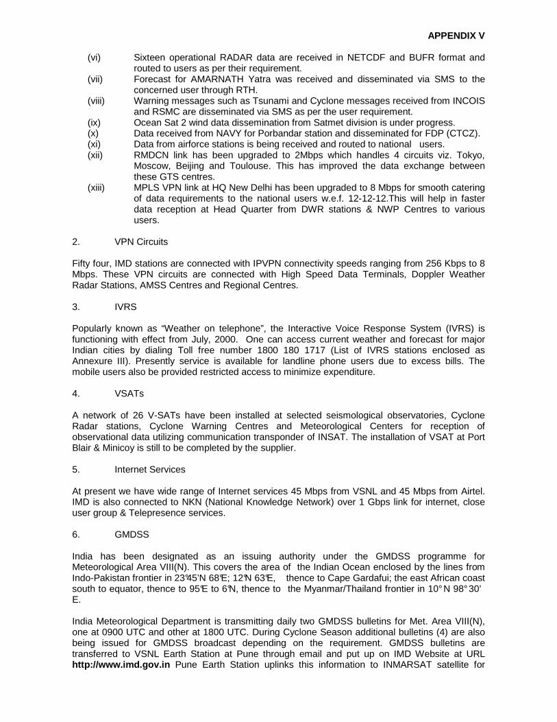
APPENDIX V
(vi) Sixteen operational RADAR data are received in NETCDF and BUFR format and routed to users as per their requirement.
(vii) Forecast for AMARNATH Yatra was received and disseminated via SMS to the concerned user through RTH.
(viii) Warning messages such as Tsunami and Cyclone messages received from INCOIS and RSMC are disseminated via SMS as per the user requirement.
(ix) Ocean Sat 2 wind data dissemination from Satmet division is under progress. (x) Data received from NAVY for Porbandar station and disseminated for FDP (CTCZ). (xi) Data from airforce stations is being received and routed to national users. (xii) RMDCN link has been upgraded to 2Mbps which handles 4 circuits viz. Tokyo,
Moscow, Beijing and Toulouse. This has improved the data exchange between these GTS centres.
(xiii) MPLS VPN link at HQ New Delhi has been upgraded to 8 Mbps for smooth catering of data requirements to the national users w.e.f. 12-12-12.This will help in faster data reception at Head Quarter from DWR stations & NWP Centres to various users.
2. VPN Circuits Fifty four, IMD stations are connected with IPVPN connectivity speeds ranging from 256 Kbps to 8 Mbps. These VPN circuits are connected with High Speed Data Terminals, Doppler Weather Radar Stations, AMSS Centres and Regional Centres. 3. IVRS Popularly known as “Weather on telephone”, the Interactive Voice Response System (IVRS) is functioning with effect from July, 2000. One can access current weather and forecast for major Indian cities by dialing Toll free number 1800 180 1717 (List of IVRS stations enclosed as Annexure III). Presently service is available for landline phone users due to excess bills. The mobile users also be provided restricted access to minimize expenditure. 4. VSATs A network of 26 V-SATs have been installed at selected seismological observatories, Cyclone Radar stations, Cyclone Warning Centres and Meteorological Centers for reception of observational data utilizing communication transponder of INSAT. The installation of VSAT at Port Blair & Minicoy is still to be completed by the supplier. 5. Internet Services At present we have wide range of Internet services 45 Mbps from VSNL and 45 Mbps from Airtel. IMD is also connected to NKN (National Knowledge Network) over 1 Gbps link for internet, close user group & Telepresence services. 6. GMDSS India has been designated as an issuing authority under the GMDSS programme for Meteorological Area VIII(N). This covers the area of the Indian Ocean enclosed by the lines from Indo-Pakistan frontier in 23°45’N 68°E; 12°N 63°E, thence to Cape Gardafui; the east African coast south to equator, thence to 95°E to 6°N, thence to the Myanmar/Thailand frontier in 10° N 98° 30’ E. India Meteorological Department is transmitting daily two GMDSS bulletins for Met. Area VIII(N), one at 0900 UTC and other at 1800 UTC. During Cyclone Season additional bulletins (4) are also being issued for GMDSS broadcast depending on the requirement. GMDSS bulletins are transferred to VSNL Earth Station at Pune through email and put up on IMD Website at URL http://www.imd.gov. in Pune Earth Station uplinks this information to INMARSAT satellite for

APPENDIX V
broadcast to all ships in Met Area VIII(N). 7. Regional Telecommunication Hub (RTH) Regional Telecommunication Hub became operational in the year 1971. RTH New Delhi was automated and first DS- 714 Philips Computer System became operational in the year 1976. This RTH Computer has been replaced by VAX- 11/ 750 Computer in 1988. In July, 2000 RTH New Delhi has installed a SUN E- 250 Computer. Latest system has been installed in the year 2010 by Meteo France International (MFI). This is connected to WMO Centres on the GTS. The existing RTH computer system is driven primarily by dual HP server working on the state-of-the-art distributed networking technology. The whole system has been designed to handle high speed data circuits, message exchange through web interface, through SMS & Email. It has also fax interface and audio alarm. NMTC New Delhi is connected to HPCS of NCMRWF through NKN and the HPCS computer at Regional Specialised Meteorological Centre (RSMC) New Delhi for instantaneous transmission of global observational data and processed information received via GTS. As regards the Meteorological Telecommunication Networks within the GTS, New Delhi telecommunication center is designated as Regional Telecommunication Hub (RTH) located on the Main Trunk Network (MTN). The MTN is the core network of GTS. It links WMO together three World Meteorological Centers (WMCs) and 14 other RTHs on the MTN. The Centre is also a National Meteorological Centre (NMC) for telecommunication purposes within the framework of GTS. RTH New Delhi is directly connected with World Meteorological Centre (WMC) Moscow, RTH Tokyo and RTH Cairo on the MTN. RTH New Delhi is also directly connected with RTH Beijing, RTH Jeddah and WMC Melbourne located on the MTN; RTHs Bangkok and Tehran and National Meteorological Centres (NMCs) Colombo, Dhaka, Karachi, Kathmandu, Male, Muscat and Yangon in the Regional Meteorological Telecommunication Networks (RMTNs). Automatic Message Switching Systems (AMSS) are also operational at the major International airports viz. Mumbai, Delhi, Kolkata, Chennai and Guwahati. The circuits linking New Delhi (Palam), Mumbai, Kolkata, Chennai and Guwahati Airport computers with the NMTC New Delhi are working at high speed. Under the Modernization programme of India Meteorological Department, following systems have been installed at RTH New Delhi:-
a. Central Information Processing System (CIPS). High end database management system having task centre to develop, test and operationalize meteorological tasks for real time generation of meteorological products.
b. Transmet: Automatic Message Switching System (AMSS) to receive, check and route the meteorological data and products according to WMO standards/requirements.
c. Public Weather System (PWS): To deliver High quality weather products and alerts to end users like print media and Television.
d. Clisys Climatological data storage system with scalable management tool for effective utilization of these data.
e. Synergie: Decision support system for forecasters to gather, visuslize, interact and value add meteorological forecasts and products.
New AMSS System at Nagpur and Guwahati has been installed and accepted and is under the stage of completion. The process of procurement and installation of Mirror RTH at Pune which will act as Disaster Recovery Centre (DRC) which should be able to take over all the responsibilities of RTH New Delhi in case of any catastrophe at RTH New Delhi. Stores have been received for the Mirror RTH at Pune and equipments are likely to be commissioned by 31st March, 2013 at site. This will also act as WMO WIS GISC for South East Asia and cater to all data needs for Indian users and all other WMO GISC centres in real time with 24 hours cache for all data. 8. Website of IMD

APPENDIX V
Website of IMD is operational since 1st June, 2000. It contains static & dynamically updated information on all India Weather and forecasts, special monsoon report, local weather forecasts for 200 cities, satellite cloud pictures (updated every half an hour), animated satellite cloud pictures, Dynamical Model (LAM) generated products and prognostic charts, special weather warnings, tropical cyclone information and warnings, daily, weekly and monthly rainfall distribution maps, earthquake reports, etc. This also contains a lot of static information including temperature and rainfall normals over the country and a brief overview of the activities and services rendered by India Meteorological Department. This site can be accessed round the clock with the URL: http://www.imd.gov.in. The Regional Meteorological Centres have also their own websites. IMD is also providing 100 Indian city forecast on the WMO Website daily at http://worldweather.wmo.int/066/m066.htm India Meteorological Department developed its own intranet website with the address http://metnet.imd.gov.in exclusively for the use of IMD staff. All employees can access this site using their login ID. This is a very useful site and all IMD officials are accessing this site all over the country for numerous applications on office matters. The list of email addresses are available at IMD website. 9. Information Technology Cell Considering the ever growing influence of Information Technology in day - today affairs of the department, a new division was formed, initially, to coordinate the various IT related activities of the department. However, considering the administrative aspects as well as the inter-operability of communication and IT, this was brought, later, under the umbrella of Information System and Services Division (ISSD). The objectives of IT Unit are: a) Coordination of IT initiatives of the department. b) Supervise various IT projects to be implemented. c) Asserting the IT literacy and imparting suitable mechanisms for its improvement. d) Development of various in-house softwares for routine activities. Conforming to these objectives, IT Division has developed an intra - IMD Portal, which is considered as the first step towards e-governance implementation in the department. Following are the services operational through this portal: i) Procurement Monitoring System ii) Personal Information System iii) IT Inventory System iv) File Tracking System v) Leave Management vi) Meteorological Photograph & Document Sharing System vii) Abroad Visitor’s Information System viii) IMD Directory Search System ix) DGM’s engagement Monitoring System x) Upper Air observatories Monitoring System xi) Mausam Journal catalogue xii) Salary and Miscellaneous payment’s display xiii) Progress Report Display and Upload xiv) Forecasting facilities xv) Fault Monitoring and Lodging System xvi) Biometric Attendance Record Updation xvii) Pensioner’s Corner viii) PROMAN Ver 2.0- Project Monitoring System xix) MIMS Ver 1.0- Met. Instruments Monitoring System

APPENDIX V
xx) DAKIA- Dak Inventory Application xxi) IMD AWAS- Online Guest House Booking and Management System xxii) APARNA Ver 1.0- Annual Performance Appraisal Report Notation & Administration. In addition, using the portal provision is made to: a) To publish seniority list, Office orders and other documents of interest to IMD employees. b) Publish Mausam Catalogue for reference. c) Download various forms for use by employees. 10. Annual Global Monitoring Annual Global Monitoring during the period 1-15th October, 2012 and the result sent to WMO via Internet. The % of SYNOP was 97.72% and TEMP 40.60%. Video Wall was commissioned in NWFC with three years comprehensive Warranty w.e.f 30-8-2010. Video Conferencing Facility with H.Q.NWFC to 8- Forecasting offices at RMCs & Pune is established. The Intra IMD Portal popularly called METNET was launched on 27th July, 2008, by the IT Unit functioning under the Information System and Service Division, India Meteorological Department as a first initiative to have coordinated approach to standardize data base and various in house e-governance related administrative with the following objectives:
• To implement e- governance concepts in IMD, • To create a suitable platform for sharing of Administration information in IMD, • To Co-Ordinate the IT efforts of various sub office of the Department, • Bring efficiency and transparency in Office work, • To reduce the delay in exchange information and making it available in proper
format, • Create an organizational setup which is tuned to use IT to optimize administrative
and scientific. Ongoing projects: Provision of adequate communication system for data and product transmission: a. Under modernization programme, India Meteorological Department procured Automatic
Message Switching System (AMSS), Central information processing System(CIPS) which will store almost all observational data , Clysis (to store Climatologcal data),High Performance Computer System (HPCS) to run the numerous numerical weather prediction model etc. Mirror RTH, Pune is a part of the WMO Information System (WIS) implementation, which includes design, development, integration with existing systems like CIPS, Clisys, AMSS, HPCs, supply and installation of WMO Information System which will act as Global Information System Centre (GISC) and Data Collection and Processing Centre(DCPC) with disaster recovery centre at Pune
� As per guideline of WMO, RTH New Delhi applied for GISC as well as DCPC for South
Asia. � Conducted training cum workshop on WMO information system and WMO expert delivered
the lecture. � After installation Mirror RTH Pune, WMO member will be invited to declare as GISC &
DCPC. � WIS for New Delhi is also under process.

APPENDIX V
� GISC/DIPC Will be functional at Mirror RTH, Pune by June,2013. b. Up Gradation of AMSS (Automatic Message Switching Systems) at Guwahati, Nagpur and
Mirrror RTH at Pune. c. On line Briefing System at Chennai & Delhi (Palam). d. Development of Centralized GIS Based content managed Website of IMD. e. Development of Met GIS – Web based GIS Portal. Maintenance of operational forecast system, delivery system for forecast and other services
(a) Maintenance and Expansion of Improved Operational Numerical Weather Prediction for Short to Medium range Weather Forecasting.
(b) Expansion and Improvement of Operational Nowcast and very short range forecast system.
(c) GIS based rainfall analysis for development of flood prone map zonation and Urban Flood forecasting model.
(d) Android based applications for dissemination of weather forecast and warning products.
(e) Establishment of IMD Pune Archives. Training activities of Telecom Training Centre(TTC) during 2012
a. Telecommunication Training Centre (TTC) was established in New Delhi September, 1977 for imparting training in Meteorological Telecommunications. It is one of the international training centres in the field of meteorological telecommunication recognized by the World Meteorological Organisation (WMO).
b. The centre has lecture rooms and Lab equipped with all state of art facilities like multimedia projector and work station in LAN. WI-FI connectivity is also available in the lecture room & computer lab.
c. The centre provides facilities for conference/ Workshops arranged by various divisions of IMD.
d. Syllabi of various Meteorological Telecommunication courses were revised keeping in view of the provision of self study/ E-Learning at working place of trainees nominated for the courses.
e. The centre has so far imparted training to 1235 departmental personnel and 88 foreign personnel sponsored under various technical cooperation programmes such as ITEC, SAARC, Colombo Plan, UNDP and WMO.
The centre conducts the following courses:-
(i) Elementary Training Course in Met. Information System (Level-I)
(Duration – 4 months)
(ii) Intermediate Course in met. Information System (level- II)
(Duration- 4 months)
(iii) Advanced course in Met. Information System (level- III)
(Duration- 6 months)
(iv) Short term course for Mechanics/Radio- Mechanics
(Duration- 1 month)
(v) Familiarisation Course in IT & Met. Telecommunication Technique
(duration- 1 month)
(vi) Short term course in Fundamental of IT & PC applications
(Duration- One month afternoon only)

APPENDIX V
5.2 Hydrology IMD provides the necessary technical and operational support to various Central/State Govt. Organisations and other agencies in the field of Hydromet design flood forecasting, water management and agricultural planning purposes. In the performance of these activities, this discipline carried out compilation of rainfall statistics, hydro meteorological analysis of different river catchments for project authorities and provided meteorological support for flood warning and flood control operations to field units of Central Water Commission. Research Programmes in (a) Design Storm Analysis, (b) Rainfall Frequency Analysis and (c) Quantitative Precipitation Forecast are the ongoing hydro meteorological activities. The main activities of the Division are; Rainfall Monitoring Real time monitoring of district wise daily rainfall is one of the important functions of IMD. A network comprising a large number of raingauge stations is utilized under District wise Rainfall Monitoring Scheme (DRMS). Based on real time daily rainfall data, weekly district wise, sub-divisionwise and statewise/seasonwise rainfall distribution summaries are prepared in the form of rainfall tables and maps. District wise and sub-divisionwise rainfall statistics provides important information useful to the agricultural scientists, planners and decision makers. The software used for preparation of districtwise rainfall summary has been modified to get outputs in Excel Format. Preparation of weekly sub-divisionwise/ districtwise/statewise rainfall reports including the statistics for the country as a whole as well for the four regions viz., North-West India, South Peninsula, Central India and North East India. During the Monsoon Season 2012 daily sub-division rainfall report were prepared and supplied to the Cabinet Secretary and other users. Distrctwise reports for last 5 years were put up on IMD Website and creation of sub-divisional rainfall maps was automated. The seasonal statistics for the year 2012 is as follows: • Winter season (Jan-Feb) 2012:- During Winter season the updated rainfall statistics is, the
country as a whole received 4% less rainfall of LPA. Out of 36 sub-divisions 8 subdivisions recorded excess rainfall, 2 recorded normal rainfall, 12 recorded deficient rainfall 11 recorded scanty rainfall and 3 subdivision recorded nil rainfall.
• Pre- monsoon (March-May) 2012:- During Pre- monsoon the updated rainfall statistics is, the country as a whole received 31% less rainfall of LPA. Out of 36 sub-divisions 1 recorded excess rainfall, 5 recorded normal rainfall, 20 recorded deficient rainfall and remaining 10 sub-divisions recorded scanty rainfall.
• SW monsoon (June-Spt.) 2012:- During the monsoon season the real-time rainfall statistics for the country as a whole received was 8% less than the LPA. East & NE India, Southern peninsula, NW India and, Central India experienced rainfall of 89%,90%,93% and 96% of LPA respectively. Out of 36 sub-divisions 1 recorded excess rainfall, 22 recorded normal rainfall and remaining 13 sub-divisions recorded deficient rainfall.
NWP modeling for heavy rainfall forecast The following modeling initiatives have been implemented at IMD during 2012. Operational implementation of ARPS model

APPENDIX V
Fig.6 IMD ARPS 850 hPa Winds and reflectivity Advance Regional Prediction System (ARPS) Model for North East Monsoon has been introduced in 2012. It is run using Initial and boundary condition from IMD Global Forecasting system (GFS). The radial velocity and reflectivity data of DWR are assimilated in ARPS Model through ADAS data assimilation package. The assimilation is performed as a sequence of intermittent cycles of 20 minutes. Reflectivity (dBZ) overlaid on wind field (knots) at 850 hPa (Fig.6), is plotted for next 3 hours updated at every hour round the clock Real time forecast from ARPS Model with Radar Data assimilation are available on http://www.imd.gov.in/section/nhac/dynamic/ARPS_NE_MON.htm. (a) Model based Quantitative Precipitation Forecast
Fig.7 QPF Forecast using NWP models
Sub-basin wise Quantitative Precipitation Forecast (QPF) for day-1, day-2, day-3 using NWP model, operational WRF ARW (9 km x 9km) and Multi-model Ensemble (0.25° X 0.25°), are computed and uploaded on the IMD’s website www.imd.gov.in operationally during flood season 2012 for 71 flood prone river sub-basins. An example is shown in Fig.7. MME for district wise heavy rainfall forecasting Under Integrated Agromet Advisory Services (IAAS) scheme, district level weather forecast upto 5 days is being issued for seven weather parameters, viz., rainfall, wind speed and direction, maximum temperature, minimum temperature, relative humidity and cloud cover. In addition, weekly cumulative rainfall forecast is also provided. IMD, New Delhi generates these products based on a Multi Model Ensemble (MME) technique using forecast products available from number of models of India and other countries. These include T-799 model of European Centre for Medium Range Weather Forecasting (ECMWF), National Centre for Environmental Prediction (NCEP), USA and Japan Meteorological Agency (JMA), Japan and IMD and NCMRF models. The products are disseminated to Regional Meteorological Centres and Meteorological Centres of IMD
APPENDIX V
located in different states. These offices undertake value addition to these products and communicate to 130 Agromet Field Units (AMFUs) located at State Agricultural Universities (SAUs), institutes of Indian Council of Agricultural Research (ICAR), IIT, etc. During 12th Five Year Plan, IMD proposes to generate block level weather forecast for issuing block level Agromet advisories using NWP products. For this, pilot studies have been undertaken in collaboration with various organizations. Flood Meteorological Service Flood Meteorological Service of IMD provides the inputs to Central Water Commission through their 10 FMO established in different parts of India for operational flood forecasting. This unit is mainly engaged in developing Quantitative Precipitation Forecast (QPF) model using different dynamical models for river basins during flood season. Design Storm Studies Design Storm Studies are being conducted to evaluate design storm estimates (rainfall magnitude and time distribution) for various river catchments/projects in the country, for use as main input for design engineers in estimating design flood for hydraulic structures, irrigation projects, dams etc. on various rivers. This estimation of design values is required for safe and optimum design of storage and spillway capacity. On the request of Central Govt. / State Govt. and Private Agencies, design storm values (Standard Project Storm, Probable Maximum Precipitation along with Time Distribution) are being provided for users as main input. For Govt. agencies, these studies are being carried out free of cost and for private/profit earning agencies on payment basis. The design storm studies for 36 projects have been completed and results communicated to the concerned project authority. The detailed project reports are being sent in respect of the projects completed on payment basis. The work of preparation of PMP Atlas for Krishna Basin has been initiated. Major Activities of Central Water Commission (CWC) CWC is charged with the general responsibility of initiating, coordinating and furthering in consultation with the State Governments concerned, schemes for the control, conservation and utilization of water resources in the respective State for the purpose of flood management, irrigation, drinking water supply and water power generation. The Commission, if so required, can undertake the construction and execution of any such scheme. In exercise of the above responsibilities, following are the main functions of CWC:
1. To carry out Techno-economic appraisal of Irrigation, flood control & multipurpose projects proposed by the State Governments.
2. To collect, compile, publish and analyze the hydrological and hydrological data relating to major rivers in the country, consisting of rainfall, runoff and temperature, etc. and to act as the central bureau of information in respect of these matters;
3. To collect, maintain and publish statistical data relating to water resources and its utilization including quality of water throughout India and to act as the central bureau of information relating to water resources;
4. To provide flood forecasting services to all major flood prone inter-state river basins of India through a network of 175 flood forecasting stations.
5. Monitoring of selected major and medium irrigation projects, to ensure the achievement of physical and financial targets. Monitoring of projects under Accelerated Irrigation Benefit Programme (AIBP), and Command Development (CAD) programme has also been included in its field of activities.
APPENDIX V
6. To advise the Government of India and the concerned State Governments basin-wise development of water resources;
7. To undertake necessary surveys and investigations as and when so required prepare designs and schemes for the development of river valleys in respect of power generation, irrigation by gravity flow or lift, flood management and erosion control, anti-water logging measures, drainage and drinking water supply;
8. To undertake construction work of any river valley development scheme on behalf of the Government of India or State Government concerned;
9. To advise and assist, when so required, the State Governments (Commissions, Corporations or Boards that are set up) in the investigation, surve1 preparation of river valley and power development schemes for particular and regions;
10. To advise the Government of India in respect of Water Resources Development regarding rights and disputes between different States for the conservation and utilization and any matter that may be referred Commission in connection with river valley development;
11. To impart training to in-service engineers from Central and State Organizations in various aspects of water resource development;
12. To initiate studies on socio-agro-economic and ecological aspects of irrigation projects for the sustained development of irrigation;
13. To conduct and coordinate research on the various aspects of river development schemes such as flood management, irrigation, navigation, power development, etc., and the connected structural and design features;
14. To promote modern data collection techniques such as remote sensing technology for water resources development, flood forecasting and development of related computer software;
15. To conduct studies on dam safety aspects for the existing dams and stand related instrumentation for dam safety measures;
16. To carry out morphological studies to assess river behaviour, bank erosion/coastal erosion problems and advise the Central and State Governments on all such matters;
17. To promote and create mass awareness regarding the progress and achievements made by the country in the water resources development, use and conservation.
5.3. Disaster prevention and preparedness 5.3.1. Cyclone Warning Services The extensive coastal belts of India are exposed to cyclonic storms, which originate in the Bay of Bengal and the Arabian Sea every year. These cyclones, which are accompanied with very heavy to extremely heavy rain, gales and storm surges cause heavy loss of human lives and cattle. They also cause extensive damage to standing crops and properties. It is the endeavour of India Meteorological Department (IMD) to minimise the loss of human lives and damage to properties due to tropical cyclones by providing early warnings against the tropical cyclones. Cyclone warning is one of the most important function of the IMD and it was the first service undertaken by the department in1865. The cyclone warnings are provided by the IMD from the Area Cyclone Warning Centres (ACWCs) at Kolkata, Chennai & Mumbai and Cyclone Warning Centres (CWCs) at Vishakhapatnam, Bhubaneswar and Ahmedabad. The complete Cyclone Warning Programme in the country is supervised by the Cyclone Warning Division (CWD) at Head Quarter Office of the Director General of Meteorology at New Delhi. The CWD monitors the cyclonic disturbance both in the Bay of Bengal and Arabian Sea and advises the Government of India at the Apex level. Information on cyclone warnings is furnished on a real time basis to the Control Room in the Ministry of Home Affairs, Government of India, besides other Ministries & Departments of the Central Government. This Division provides cyclone warning

APPENDIX V
bulletins to Doordarshan and All India Radio (AIR) station at New Delhi for inclusion in the National broadcast/telecast. Bulletins are also provided to other electronic and print media and concerned state govts. The Deputy Director General of Meteorology (Cyclone Warning) and Deputy Director General of Meteorology (Weather Forecasting) Pune monitor technical aspects and review the standard practices in the area of cyclone forecasting. 5.3.2. Cyclone warning bulletins The following is the list of bulletins and warnings issued by ACWCs/CWCs for their respective areas of responsibility:
1. Sea area bulletins for ships plying in High Seas. 2. Coastal weather bulletins for ships plying in coastal waters. 3. Bulletins for Global Marine Distress and Safety System (GMDSS). Broadcast through
Indian Coastal Earth Stations. 4. Bulletins for Indian Navy. 5. Port Warnings. 6. Fisheries Warnings. 7. Four stage warnings for Central and State Govt. Officials. 8. Bulletins for broadcast through AIRs for general public. 9. Warning for registered users. 10. Bulletins for press. 11. Warnings for Aviation (issued by concerned Aviation Meteorological Offices). 12. Bulletins for ships in the high seas through Navtex Coastal Radio Stations.
The cyclone warnings are issued to state government officials in four stages. The First Stage warning known as "PRE CYCLONE WATCH" issued 72 hours in advance contains early warning about the development of a cyclonic disturbance in the north Indian Ocean, its likely intensification into a tropical cyclone and the coastal belt likely to experience adverse weather. This early warning bulletin is issued by the Director General of Meteorology himself and is addressed to the Cabinet Secretary and other senior officers of the Government of India including the Chief Secretaries of concerned maritime states. The Second Stage warning known as "CYCLONE ALERT" is issued at least 48 hrs in advance of the expected commencement of adverse weather over the coastal areas. It contains information on the location and intensity of the storm likely direction of its movement, intensification, coastal districts likely to experience adverse weather and advice to fishermen, general public, media and disaster managers. This is issued by the concerned ACWCs/CWCs and CWD at HQ. The Third Stage warning known as "CYCLONE WARNING" issued at least 24 hours in advance of the expected commencement of adverse weather over the coastal areas. Landfall point is forecast at this stage. These warnings are issued by ACWCs/CWCs/and CWD at HQ at 3 hourly interval giving the latest position of cyclone and its intensity, likely point and time of landfall, associated heavy rainfall, strong wind and storm surge alongwith their impact and advice to general public, media, fishermen and disaster managers. The Fourth Stage of warning known as "POST LANDFALL OUTLOOK" is issued by the concerned ACWCs/CWCs/and CWD at HQ at least 12 hours in advance of expected time of landfall. It gives likely direction of movement of the cyclone after its landfall and adverse weather likely to be experienced in the interior areas. Different colour codes as mentioned below are being used in since post monsoon season of 2006 the different stages of the cyclone warning bulletins as desired by the National Disaster Management.

APPENDIX V
Stage of warning Colour code Cyclone Alert Yellow. Cyclone Warning - Orange. Post landfall out look Re d. During disturbed weather over the Bay of Bengal and Arabian Sea, the ports likely to be affected are warned by concerned ACWCs/CWCs by advising the port authorities through port warnings to hoist appropriate Storm Warning Signals. The Department also issues "Fleet Forecast" for Indian Navy, Coastal Bulletins for Indian coastal areas covering up to 75 km from the coast line and sea area bulletins for the sea areas beyond 75 km. The special warnings are issued for fishermen four times a day in normal weather and every three hourly in accordance with the four stage warning in case of disturbed weather. The general public, the coastal residents and fishermen are warned through State Government officials and broadcast of warnings through All India Radio and Doordarshan telecast programmes in national and regional hook-up. A system of warning dissemination for fishermen through World Space Digital Based radio receivers is being planned. Specific objectives A revised stages of cyclone warning (7 stages instead of the present 4 Stages of Warning) has been suggested by NDMA of Govt. of India headed by top officials of the government. The same is being deliberated further and with some modifications will be implemented from the ensuing cyclone season. It is also proposed to modify the format of Cyclone Warning bulletins to make it more comprehensive for the use of Disaster Managers. The possibility of automation in generating the bulletins through a suitable software whereby several different bulletins which are focused towards the needs of specific groups such as fishermen, shipping, AIR, press, port etc. which could be generated from a single bulletin format is being pursued by Cyclone Warning Division at New Delhi. 5.3.3 Cyclone Warning Dissemination Cyclone warnings are disseminated through a variety of communication media, such as, radio, television, print media, telephones, fax, telex, telegrams, police, wireless network. A specially designed Cyclone Warning Dissemination System (CWDS) which works via the INSAT Satellite provides area-specific service even when there is a failure of conventional communication channels. A set of 250 analog and 100 digital CWDS receivers have been employed in vulnerable coastal areas in the east and west coast. Orders are being placed shortly for 300 new CWDS (Cyclone Warning Dissemination Systems), which are modern and easy to maintain. 5.3.4 Disaster Management National Disaster Management Authority (NDMA ) About 8% of the area in the country is prone to cyclone-related disasters. Recurring cyclones account for large number of deaths, loss of livelihood opportunities, loss of public and private property and severe damage to infrastructure, thus seriously reversing developmental gains at regular intervals. Broad-scale assessment of the population at risk suggests that an estimated 32 crore people, which accounts for almost a third of the country’s total population, are vulnerable to cyclone related hazards. Climate change and its resultant sea-level rise can significantly increase the vulnerability of the coastal population. As mandated by Disaster Management Act, 2005, the Government of India (GoI) created a multi-tiered institutional system consisting of the National Disaster Management Authority (NDMA) headed by the Prime Minister, the State Disaster Management Authorities (SDMAs) by the

APPENDIX V
respective Chief Ministers and the District Disaster Management Authorities (DDMAs) by the District Collectors and co-chaired by Chairpersons of the local bodies. These bodies have been set up to facilitate a paradigm shift from the hitherto relief centric approach to a more proactive, holistic and integrated approach of strengthening disaster preparedness, mitigation and emergency response. Guidelines for the Management of Cyclones The NDMA has prepared Guidelines for the Management of Cyclones to assist ministries and departments of GoI and state governments to prepare their DM plans. The guidelines are presented in nine chapters as detailed below:
i. Chapter 1 provides an introductory overview that reflects the risk and vulnerability of the country to cyclones, including the dimensions and magnitude of the problem.
ii. Chapter 2 discusses the Early Warning Systems (EWS) for cyclones. In this chapter, the present status of EWSs has been discussed and the gaps have been identified. Requirement to bring them up to international standards and making them state-of-the-art systems has been recommended.
iii. Chapter 3 deals with the present status of Warning Communication and Dissemination, its gaps and future improvements required towards making it fail-proof and modern.
iv. Chapter 4 covers structural measures for preparedness and mitigation, covering cyclone shelters, buildings, road links, culverts and bridges, canals, drains, saline embankments surface water tanks, cattle mounds and communication/power transmission networks.
v. In Chapter 5, important aspects of the management of coastal zones and its relevance to CDM, including some other non-structural mitigation options have been presented. This chapter discusses issues related to coastal zone management, sustainability of coastal resources, bioshields, coastal flood plain management, coastal erosion, natural resources management, etc.
vi. Chapter 6 deals with various aspects of awareness generation related to CDM as an important preparedness measure.
vii. Chapter 7 covers Disaster Risk Management (DRM) issues, risk assessment and vulnerability analysis, hazard zoning and mapping, data generation, including the use of GIS tools, and capacity development.
viii. Chapter 8 deals with CDM-related response and relief strategies. A detailed account of several issues related to effective response such as response platforms, linking risk knowledge with response planning, evolving disaster response capabilities, etc., is brought out in this chapter.
ix. In Chapter 9, guidelines and implementation strategies have been discussed. x. Salient initiatives recommended for implementation as part of the National Guidelines for
Management of Cyclones are listed for undertaking action by various relevant Departments. xi. The detail Guideline is hoisted in the NDMA website.
CURRENT STATUS
1. Meetings related to cyclone preparedness and disaster management conducted by the State Govt. departments are regularly attended by IMD officers to provide necessary briefings and inputs.
2. Frequent lectures on Disaster Preparedness and Mitigation are delivered to educate the State Govt. officials and NGOs.
3. Exhibits on Statistics on frequencies of landfalling Tropical Cyclones over the coastal belts of North Indian Ocean, Cyclone Warning procedures employed by IMD, Damages caused

APPENDIX V
due to landfalling cyclones etc. are prepared every year with updated data and displayed in the meteorological exhibition conducted during the WMO Day and National Science Day.
4. Exhibits are also supplied to schools and other academic/ govt. institutions for display during scientific programmes. IMD officials also participate in such exhibitions.
On-going Projects 1. WMO-RIMES project on Reducing risks of tsunami, storm surges, large waves and other natural hazards in low elevation coastal zones IMD works in collaboration with WMO and Regional Integrated Multi-hazard Early Warning System for Africa and Asia (RIMES) on an applied research project -‘Reducing risks of tsunami, storm surges, large waves and other natural hazards in lo w elevation coastal zones ’ which is supported by United Nations Economic and Social Commission for Asia and the Pacific (ESCAP). The project aims to reduce tsunami, storm surges, large waves and other hazard risks in low elevation coastal zones by strengthening institutional systems for end-to-end warning, and building institutional capacities for the application of warning information products in decision-making. The project is being implemented initially in Bangladesh, India, Maldives, Myanmar, Sri Lanka and Thailand from May 2011 to April 2013. While in other project countries, the activities are at the national level, considering India’s vastness and complexity, Tamil Nadu has been chosen as the representative state, and based on the experiences; the activities could be replicated in other parts of India. The key aspect of this project is that it will assist in strengthening application of IMD products in Tamil Nadu and in obtaining feedback for further refining our products to meet user-specific information requirements from key sectors in Tamil Nadu such as agriculture, fisheries, animal husbandry and water resources. CWRC, RMC, Chennai coordinates the project. A project working group meeting on ‘Integrating IMD Forecast Information products into planning and programmes of climate sensitive sectors’ was convened on 21st February 2012 at Regional Meteorological Centre, Chennai. Tamil Nadu State Govt. officials from the departments of agriculture, fisheries, public works and disaster management participated in the meeting. 2. Supply of Cyclone eAtlas-IMD CD (a) Cyclone eAtlas – IMD , a software for generation of tracks and statistics of cyclones and depressions over the North Indian Ocean was brought out by IMD during 2008. The database for the software is updated and sent to all buyers of the CD every year. (b) Web eAtlas: The web enable eAtlas of tracks and statistics of cyclonic disturbances since 1891 is made available on IMD Website(www.imd.gov.in) on Cyclone page.
3. Cyclone Hazard Prone Districts Map of India

APPENDIX V
Fig.5 Cyclone Hazard Prone Districts Map of India
As per the recommendations of the sub-committee constituted by National Disaster Management Authority (NDMA), the Cyclone Hazard Prone Districts Map of India has been prepared based on frequency of cyclones affecting the districts, frequency of severe cyclones affecting the districts, probable maximum precipitation over the districts, maximum wind strength over the districts due to the cyclone and probable maximum storm surge over the districts (Fig.5). 4. Experimental efforts are on for Cyclone Intensity and Track prediction based on WRF model. Track and Intensity predictions were generated on real time basis (experimental) and validated in respect of the Cyclonic Storm Nilam over the Bay of Bengal during 28 October -01 November 2012. 5. Dr.S.Balachandran, Scientist-E, participated in the inaugural day proceedings of ‘Climate Risk Management Farmers’ Field School ’ organised by the Regional Integrated Multi-hazard Early Warning System, Thailand and Centre for Ecology and Research, Thanjavur at the Tamil Nadu Rice Research Institute, Aduthurai on 3rd July 2012 and delivered a technical talk on the occasion. 5.4 Training (a) International Level: RSMC, New Delhi is regularly conducting training on operational Tropical Cyclone Forecasting since 2005 for the Panel member countries. In year 2012, three participants from Sri Lanka, Thailand and Maldives were given training during 20 February to 2 March, 2012. (a) National Level: The training activities at RMTC Pune are as follows: I) Current Status: The following regular courses are running at Central Training Institute Pashan,Pune
i) Advanced Meteorological Training Course in General Meteorology ii) Forecasters Training Course in General Meteorology iii) Intermediate Training Course in General Meteorology

APPENDIX V
In addition to these courses, the refresher courses on the thematic topics are also being conducted. During the year 2012, advance refreshers course on ‘Application of DWR products on NWP’ was conducted at CTI, Pune during 19 November -24 November 2012. II) On going projects: Under World Bank aided Hydrology Project Phase II, the following regular courses are running:
i) Basic Hydromet Observer Course ii) Hydromet Supervisor’s Course iii) Senior Level refresher course
III) Future Plans:
a. To design and organise advanced refresher training course of duration ranging from 2-4 weeks for the meteorological personnel of developing/under developed countries in the RA-II region on different important topics like NWP, Tropical Cyclone, Aviation Meteorology, Agrimet, Sat. Met, DWR etc.
b. To design and organise advanced refresher training course of 10 weeks duration for the forecasters of Rwanda Met. Agency.
c. To introduce e-learning in training programme. d. To upgrade the infrastructure of training institute & Trainees Hostel. e. To revise the syllabus /Course contents of the different training courses.
Annual Training Calendar for the Year 2012 – 2015 is given below: Routine Courses in IMD S. No.
Course Name Duration Date of commencement
Eligibility Criteria
1. Advanced Met Training Course
One year Second Monday of September of every year
B.Sc*. (with Physics or Maths as main subject) /M.Sc./B.E./ B.Tech.
2. Forecasting Training Course
Six months Second Monday of March and September every year
B.Sc. (with Physics or Math as main subject) and after successful completion of Intermediate Met. Training course
3. Intermediate course in General Meteorology (For Basic Met Training course trained personnel)
Three months
Four batches per year starting in February, May, August and November every year
B.Sc. (with Physics or Maths as main subject) after successful completion of Basic Met. Training course.
4 Integrated Basic Training Course
Six months Ab-initio training Fresh recruited Scientific Asst. with B.Sc.(Phy., Math) qualification
5 Lab Assist Modular Course
Two months Second Monday of February, June and October every year
Departmental Met. Attendant who have passed SSC and working in same cadre for 5 years
6 Training Course for Radio Mech. / Mech. Asst/ Mech. Grade I
3 weeks Twice in a year Departmental candidates with I T I qualification
Courses under Hydrology Project Phase II S.N. Name of the Course Frequency/year Duration
1 Basic Hydromet Observer’s Course for Observers 3 batches per year 19 days

APPENDIX V
2 Hydromet Supervisor Course for Asst/Section Engineers 2 batches per year 12 days
3 Senior Level Refresher Course for Executive Engineers 1 batches per year 5 days
Note: At least three Refresher Courses are being conducted at this Institute per year, the themes for the same will be decided as per the requirement projected by the USER Agencies. Future Plan: 1. The seminars/workshops will be conducted for the cyclone forecasters in India during March and September 2013 as pre-cyclone exercise. 5.5 Research 1. Forecast Demonstration Project on landfalling cyclones over the Bay of Bengal Cyclone Warning & Research Centre (CWRC) at Regional Meteorological Centre (RMC), Chennai is the Field Operational Centre (FOC) of the project and is involved in co-ordinating with the participating scientific organisations, IMD’s coastal field stations and Sagar Kanya cruise regarding notification of Intense Observation Periods (IOP) by the National Operational Centre (NOC) functioning from IMD, New Delhi. IMD personnel are deputed on tour to some non-regular field stations to cover special observations. Daily and weekly reports on status of observations are sent to NOC regularly. 2. Forecast Demonstration Project (FDP) on Continental Tropical Convergence Zone (CTCZ) The monsoon rainfall mainly depends on the activity of monsoon trough. The part of monsoon trough lying over the land region is called as CTCZ. The CTCZ is responsible for spatio-temporal variability of monsoon rainfall over India. So, for better understanding and prediction of characteristic features of CTCZ and associated rainfall, an FDP on CTCZ has been taken up since 2010 as a multi-institutional campaign. This year the programme was conducted during (1 July-30 Sep) in Monsoon season. 3 Forecasting System for Thunderstorm and Hailstorm During 2012, the following initiatives have been implemented at IMD for forecast of thunderstorm and hail storm (i) Meso-scale model ARPS The storm scale model ARPS (Advanced Regional Prediction System) was implemented for the Delhi and Kolkata region at the horizontal resolution of 9 km with the assimilation of Doppler Weather Radar observations. (ii) Nowcasting and very short range forecasting systems (0-6 hours) For nowcasting purposes, application software called “Warning Decision Support System Integrated Information (WDSS-II)”, developed by National Severe Storm Lab, USA has been used in experimental mode. For mesoscale forecasting, radar data has been assimilated into the ARPS mesoscale model. With the ingesting of Indian DWR observations, the application software is capable of detecting and removing anomalous propagation echoes. Apart from the above, Doppler Weather Radar (DWR) is very helpful in nowcasting of severe weather events like thunderstorm and hailstorm. DWR gives number of derived products (images) from the three base products viz. Reflectivity, Velocity and Spectrum Width products which can be readily used for nowcasting and more accurate monitoring and warnings for severe weather events

APPENDIX V
like flash floods, thunderstorms, dust storms, heavy rainfall, Gale winds, hail etc. Timely warnings of these severe weather events can save more lives and minimize the damages to properties. Frequency of observations: Doppler Weather Radars which are installed & commissioned operating round the clock (24x7) at 10 minutes interval. So far 550 AWS, 878 ARGs systems have been installed & commissioned at various sites. One TDMA type AWS data receiving station has been installed also under the project 550 AWS. The data recorded by these AWS proved to be very useful in issuing operational weather forecast in very short range.
(iii) Forecast Demonstration Project (FDP) on Severe Thunderstorm Observation and Regional Modeling (STORM)
The thunderstorm is a natural hazard for the country, especially over east and north east India. Many people die every year due to thunderstorm. In order to improve monitoring and prediction of these thunderstorms, an FDP on STORM has been taken up since 2007. Since 2011, the SAARC countries like Bangladesh, Nepal and Bhutan are also participating in this programme. The FDP on STORM was continued during 2012 and special observational and forecast demonstration campaign was conducted during 15 April- 31May 2012. CURRENT STATUS Research works pertaining to statistical, climatological and dynamical aspects of Tropical Cyclones of North Indian Ocean are undertaken regularly. Some recent efforts are listed below: 1. Statistical prediction of seasonal Tropical Cyclone over the North Indian Ocean An experimental outlook on the seasonal Tropical Cyclone activity over the North Indian Ocean for the period October-December 2012 was prepared on real-time basis (during September 2012) and validated at the end of the season. Efforts are on for improving the prediction model. 2 Project TCRAIN A project on ‘Tropical Cyclone Rainfall Analysis for North Indian Ocean - TCRAIN’ was recently undertaken at CWRC, RMC Chennai and rainfall characteristics of 43 Tropical Cyclones that affected North Indian Ocean during the period 2000-2010 were determined using TRMM data. The necessary software for generation of percentage frequency distribution of rain rates, azimuthally averaged radial profiles of rain rates and quadrant-wise mean rain rates around a cyclone centre and with respect to the direction of movement of the cyclone using 3hrly TRMM data has been developed in-house. The products are generated for different stages of intensity of the system viz., (i) Depression, (ii) Cyclonic Storm and (iii) Severe Cyclonic Storm and above during its growth as well as decay for all the 43 cyclones. The products are displayed through menu-driven user interface and are proposed to be uploaded in the RMC Chennai website shortly. ON-GOING PROJECTS 1. A brain storming session on Tropical Cyclone Research in India is proposed to be conducted by CWRC, RMC Chennai. FUTURE PLANS 1. Cyclone Warning & Research Centre, functioning from the Regional Meteorological Centre, Chennai is proposed to be upgraded as National Tropical Cyclone Research Centre , during the next five years. 5.5.1. Papers published in Mausam

APPENDIX V
1. Statistical Prediction of Seasonal Cyclonic Activity over North Indian Ocean by S.
Balachandran and B. Geetha 2. Satellite Derived Sea Surface Temperature Variability in the Bay of Bengal by O. P. Singh. 3. Investigation of Features of May, 2001 Tropical Cyclone over the Arabian Sea through
IRS-P4 and other Satellite Data by P. N. Mahajan, R. M. Khaladkar, S. G. Narkhedkar, Sathy Nair, Amita Prabhu And M. Mahakur
4. Rainfall Estimation of Landfalling Tropical Cyclones over Indian Coasts through Satellite Imagery By Charan Singh, Sunit Das, R. B.Verma, B. L. Verma And B. K. Bandyopadhyay.
5. Cyclones and Depressions over the North Indian Ocean During 2011 by Dr. Medha Khole, Sunitha Devi S. and M. V. Mande.
6. Doppler Weather Radar Analysis of Short Term Cyclonic Storm by D. Pradhan, U. K. De. 7. The Relationship between Geopotential Height and Movement & Landfall of Tropical
Cyclone in the Bay of Bengal Region By G. K. Das, S. K. Midya, G. C. Debnath, S. N. Roy.
8. Outcomes and Challenges of Forecast Demonstration Project (FDP) on Landfalling Cyclones over the Bay of Bengal by M. Mohapatra, D. R. Sikka, B. K. Bandyopadhyay And Ajit Tyagi.
9. Large-Scale Characteristics of Rapidly Intensifying Tropical Cyclones over the Bay Of Bengal and A Rapid Intensification (RI) Index by S. D. Kotal And S. K. Roy Bhowmik.
10. Comparison of Best Track Parameters of RSMC, New Delhi with Satellite Estimates over North Indian Ocean by Suman Goyal, M. Mohapatra and A. K. Sharma.
11. Barotropic Energetics analysis of Tropical Cyclone Khai Muk by S. Balachandran. 12. Track, Intensity and few Dynamical Aspects of ‘Aila’ as Simulated by Operational NWP
Model of The IAF by T. P. Srivastava and Anil Devrani. 13. A Case Study for Cyclone ‘Aila’ for Forecasting Rainfall Using Satellite Derived Rain Rate
Data by Habibur Rahaman Biswas, P. K. Kundu And D. Pradhan. 14. Studies On VIF Atmospherics during the Tropical Cyclone “Aila” and several Monsoon
Period Thunderstorms over North-East India by Rakesh Roy, Anirban Guha, Barin Kumar De And Abhijit Choudhury.
15. Observational Aspects including Weather RADAR for Tropical Cyclone Monitoring by S. Raghavan.
16. Recent Advances in Observational Support from Space-Based Systems for Tropical Cyclones by R. C. Bhatia and A. K. Sharma.
17. Estimation of Intensity of Tropical Cyclone over Bay of Bengal using Microwave Imagery by T. N. Jha, M. Mohapatra and B. K. Bandyopadhyay.
18. A Study on High Resolution Mesoscale Modeling Systems for Simulation of Tropical Cyclones over the Bay of Bengal by U. C. Mohanty, Krishna K. Osuri And Sujata Pattanayak.
19. Impact Of Cyclone Bogusing And Regional Assimilation on Tropical Cyclone Track And Intensity Predictions by Manjusha Chourasia, R. G. Ashrit And John P. George.
20. Tropical Cyclone Genesis Potential Parameter (GPP) and its application over the North Indian Sea by S. D. Kotal And S. K. Bhattacharya.
21. A Preliminary Study about the prospects of Extended Range Forecast of Tropical Cyclogenesis over the North Indian Ocean during 2010 Post-Monsoon Season by D. R. Pattanaik, M. Mohapatra, B. Mukhopadhyay and Ajit Tyagi
22. Ocean Atmospheric Coupled Model to Estimate Energy and Path of Cyclone near the Coast by Ramkrishna Datta.
23. Numerical Simulation of Storm Surge associated with Severe Cyclonic Storms in the Bay of Bengal during 2008-11 by S. K. Dube, Jismy Poulose and A. D. Rao.
The following research papers have been communicated to journals for publication:
i. A paper entitled “Decadal variations in translational speeds of cyclonic disturbances over North Indian Ocean” by B. Geetha and S. Balachandran in Mausam.

APPENDIX V
ii. A paper entitled “Characterisation and Asymmetry analysis of Rainfall distribution associated with Tropical Cyclones over Bay of Bengal: NISHA (2008), LAILA (2010) and JAL (2010) by S. Balachandran and B. Geetha in Mausam.
iii. A paper entitled “Energetics of Super Cyclone ‘Gonu’ and Very Severe Cyclonic Storm ‘Sidr’ ” by Sunitha Devi S, Somenath Dutta and K. Prasad in Mausam.
5.5.2 Workshop/Seminar/lectures organised in India
1. The second WMO International Conference on Indian Ocean Tropical and Cyclone Change (IOTCCC) was held at New Delhi during 14-17 February 2012. The conference was inaugurated by Hon’ble Vice Chairman Sh. M. Shashidhar Reddy on 14th February 2012 and Dr. Shailesh R. Nayak, Secretary, Ministry of Earth Sciences presided over the inaugural function. About 150 delegates including 32 foreign delegates participated in the conference. There were four plenary sessions, 14 parallel technical sessions, two panel discussions and a concluding session. There were invited talks by the eminent scientists in the field of cyclone and climate change impact on cyclones over the Indian Ocean in the plenary sessions and beginning of each parallel, technical sessions. The several recommendations have been adopted at the end of the conference for further action. During the inaugural function following two books were released:
2. Agricultural Meteorology Division, India Meteorological Department, Pune, World Meteorological Organisation, Geneva and SAARC Agriculture Centre, Bangladesh jointly organized the Consultation Meeting on “Operational Agrometeorological Services in SAARC and other countries in RA II region” at National Meteorological Training Institute, Pune from 20-21 April 2012. A number of high level dignitaries viz. Dr. A. K. Azad, Director, SAARC Agriculture Centre, Mr. Robert Stefanski, Chief Agricultural Meteorology Division, WMO, Geneva, Prof. R. R. Kelkar, Former DGM, AVM (Dr.) Ajit Tyagi, Former DGM, Dr. K. J. Ramesh, Sc.‘G’, DST, Dr. S. Sardesai, Sc.’G’, NIC participated in the meeting. The objective of the meeting was to share the ideas and understanding of agromet advisories services among the agrometeorologist from SAARC and non-SAARC countries in the RA-II which will ultimate boost the agriculturist activities and also benefit both the group of countries
3. A 3 days capacity building training workshop on “Seasonal Prediction of Southwest Monsoon Rainfall” conducted at the India Meteorological Department Pune during 16-18 April, 2012. The training workshop was attended by representatives from 7 South Asian countries, namely, Bangladesh, Bhutan, India, Maldives, Myanmar, Nepal, and Sri Lanka. An expert from (SAARC Meteorological Research Centre, Dhaka Bangladesh), also participated. Experts from the IMD and the Indian Institute of Tropical Meteorology, Pune and international experts from UK Met. Office and Japan Meteorological Agency participated in the training workshop as resource persons.
4. Third meet of South Asian Climate Outlook Forum (SASCOF-3) was organized by IMD / IITM during 19-20 April which was attended by representatives from 7 South Asian countries, experts from IMD and IITM, Pune and international experts from UK Met Office, Japan Meteorological Agency and Korea Meteorological Administration. Representatives from the WMO and scientists from C-DAC, Pune, and Centre for Mathematical Modelling and Computer Simulation, Bangalore, took active part in deliberations for finalizing the consensus outlook for the summer monsoon rainfall over South Asia. There were 42 participants from 9 countries. In addition, around 20 experts from the national agro- meteorological services of the SAARC nations and an expert from the WMO also joined the forum.
5. The Agromet Core course meant for university Professors, Readers, Scientists from various agricultural/ agrometeorological research organizations/ICAR institutions/ universities was conducted from 24th April to 14th May, 2012. Total 14 participants (Professors/Scientists) from various Agricultural Universities throughout the country joined the course. The course content included various aspects of Agricultural Meteorology including climate change impact on crops, crop simulation modeling, crop yield forecasting, and application of remote sensing in addition to operational Agromet Advisory Service.

APPENDIX V
6. On-the-job Training of Intermediate (Gen. Met.) Batch No. 226 has been imparted to trainees at RC Kolkata as per schedule of NMTI, Pune during 30 April to 5 May 2012.
7. A training programme was arranged by Hydromet division on mkRAIN software during 3-4th May, 2012 at training centre, New Delhi. The officers from RMCs, MCs, and FMOs attended the programme. Inaugural address was given by Dr. L. S. Rathore, DGM followed by training lectures given by officers from Hydromet Division. During the period a lecture on DRMS Rainfall Data Processing through mkRAIN software was arranged.
8. A training program on ’Vrishti’, a Geographical Information System for river basin rainfall data processing was held by Hydromet division, New Delhi in three phases, during 30 May-1 June and 4-6 June at HQ, New Delhi and during 12-14 June 2012 at Kolkata. The trainee participants were from the Flood Met. Offices and also from RMCs/MCs.
9. Three weeks Agromet Observers’ course meant for grass-root level observers, was conducted from 4 June 2012 to 22 June 2012. Eight participants from the vast network of various Agromet. and other observatories under different State Agricultural Universities/ICAR Institutions, State Department of Agriculture participated in the course.
10. Dr. Medha Khole, DDGM (WF), participated in ‘Web Portal Review Meeting “ on 11th and 16th of January 2012 at C-DAC, Pune.
11. Dr. Medha Khole, DDGM (WF), delivered a lecture on “Extreme Weather Phenomena” at NFAI Auditorium, Law College Road, Pune organized by Vishwa Scientific and National Film Archive of India in association with Vigyan Prasar, Govt. Of India on 20th - 22nd.
12. Dr. Medha Khole, DDGM (WF), delivered a lecture on “Services rendered by IMD: An Overview” at a seminar hosted by C-DAC on Interdisciplinary application of Weather and Climate-Computational perspective.
13. Shri P.H.R. Rao, A.M.II, Shri M. V. Mande, SA, Shri Jhonson Samuel and Shri V.B. Kadam, S.A. attended the Training Workshop cum National Seminar on “Challenges Developments and Opportunities in Nowcasting” at New Delhi during 27th – 29th January 2012.
14. Mr. Michel Jarraud, Secretary General, World Meteorological Organization, Geneva, Switzerland visited IMD, Pune, on 21st. Dr. Medha Khole, DDGM (WF), participated in the meeting of Secretary General, World Meteorological Organization with IMD officers and made a presentation on ‘Activities of O/o DDGM (WF)’. The Secretary General also visited Weather Central and INOSHAC and was briefed upon the operational activities of the section and utilization of SYNERGIE workstation in Weather Forecasting during his visit alongwith AVM Dr. Ajit Tyagi (Ex. DGM).
15. Members of the 25th Session of WMO EC Panel of experts on Education and Training visited Weather Section on 29th. They were briefed about activities of Weather Section and INOSHAC related to Training.
16. Dr.Medha Khole, Scientist E, DDGM(WF) delivered an invited lecture on the topic , “Early warning systems of IMD pertaining to Cyclones” at YASHADA, Pune on 8th at the Maharashtra State Government’s one day Workshop on Monsoon Preparation and Hydro Meteorological Hazards.
5.5.3 Workshop/Seminar/lectures attended outside India Dr. S. K. Roy Bhowmik Sc. ‘F’ was on deputation to SAARC Meteorological Research Centre, Dhaka to attend Meeting of the Focal Points on “Formulation of Inter-Governmental Monsoon Initiative Programme” held in SAARC Meteorological Research Centre, Dhaka, Bangladesh during 30 to 31 May 2012. Shri R. K. Giri, Scientist ‘D’ visited Kathmandu, Nepal during 23 to 25 May, 2012 to attend the HCOS project 4th regional steering committee meeting. Shri N.K. Pangasa Scientist ‘F’ visited Cairo, Egypt during 29 to 31 May, 2012 to attend Seventeenth Meeting SADISOPGS (Satellite Distribution operator group system) organized by ICAO Montreal.
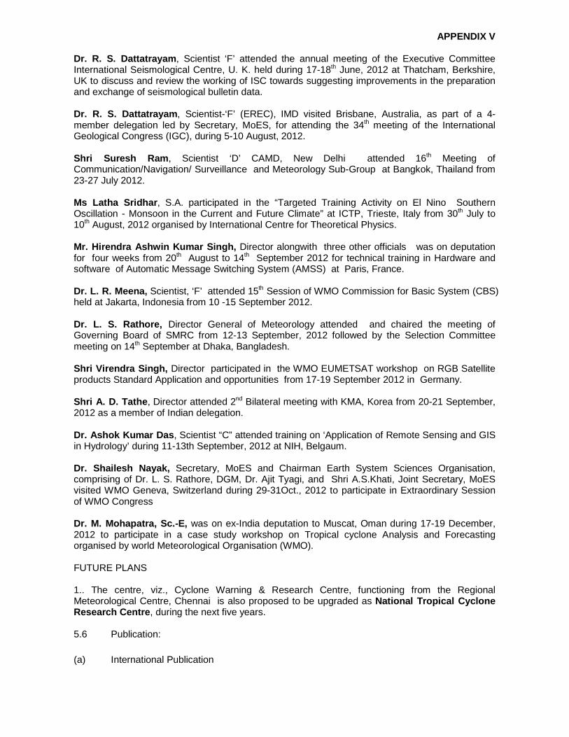
APPENDIX V
Dr. R. S. Dattatrayam , Scientist ‘F’ attended the annual meeting of the Executive Committee International Seismological Centre, U. K. held during 17-18th June, 2012 at Thatcham, Berkshire, UK to discuss and review the working of ISC towards suggesting improvements in the preparation and exchange of seismological bulletin data. Dr. R. S. Dattatrayam , Scientist-‘F’ (EREC), IMD visited Brisbane, Australia, as part of a 4-member delegation led by Secretary, MoES, for attending the 34th meeting of the International Geological Congress (IGC), during 5-10 August, 2012. Shri Suresh Ram , Scientist ‘D’ CAMD, New Delhi attended 16th Meeting of Communication/Navigation/ Surveillance and Meteorology Sub-Group at Bangkok, Thailand from 23-27 July 2012. Ms Latha Sridhar , S.A. participated in the “Targeted Training Activity on El Nino Southern Oscillation - Monsoon in the Current and Future Climate” at ICTP, Trieste, Italy from 30th July to 10th August, 2012 organised by International Centre for Theoretical Physics. Mr. Hirendra Ashwin Kumar Singh, Director alongwith three other officials was on deputation for four weeks from 20th August to 14th September 2012 for technical training in Hardware and software of Automatic Message Switching System (AMSS) at Paris, France. Dr. L. R. Meena, Scientist, ‘F’ attended 15th Session of WMO Commission for Basic System (CBS) held at Jakarta, Indonesia from 10 -15 September 2012. Dr. L. S. Rathore, Director General of Meteorology attended and chaired the meeting of Governing Board of SMRC from 12-13 September, 2012 followed by the Selection Committee meeting on 14th September at Dhaka, Bangladesh. Shri Virendra Singh, Director participated in the WMO EUMETSAT workshop on RGB Satellite products Standard Application and opportunities from 17-19 September 2012 in Germany. Shri A. D. Tathe , Director attended 2nd Bilateral meeting with KMA, Korea from 20-21 September, 2012 as a member of Indian delegation. Dr. Ashok Kumar Das , Scientist “C” attended training on ‘Application of Remote Sensing and GIS in Hydrology’ during 11-13th September, 2012 at NIH, Belgaum. Dr. Shailesh Nayak, Secretary, MoES and Chairman Earth System Sciences Organisation, comprising of Dr. L. S. Rathore, DGM, Dr. Ajit Tyagi, and Shri A.S.Khati, Joint Secretary, MoES visited WMO Geneva, Switzerland during 29-31Oct., 2012 to participate in Extraordinary Session of WMO Congress Dr. M. Mohapatra, Sc.-E, was on ex-India deputation to Muscat, Oman during 17-19 December, 2012 to participate in a case study workshop on Tropical cyclone Analysis and Forecasting organised by world Meteorological Organisation (WMO). FUTURE PLANS 1.. The centre, viz., Cyclone Warning & Research Centre, functioning from the Regional Meteorological Centre, Chennai is also proposed to be upgraded as National Tropical Cyclone Research Centre , during the next five years. 5.6 Publication: (a) International Publication

APPENDIX V
Annual Review of Tropical Cyclones The Annual Review for the year 2011 has been published by WMO. The Annual Review for the year 2012 is in progress and will be completed by the end of February and will be sent to Chief of PTC by the first week of March, 2013. Dr. M. Mohapatra will work as National Editor and Mr. B. K. Bandyopadhyay will work as Chief Editor for the Annual Review for the year 2013. Tropical Cyclone Plan The Tropical Cyclone Plan (TCP-21) edition 2012 has been completed and being published by WMO.
(b) National Publications
1. The proceeding of two days conference on Bay of Bengal Tropical Cyclone Experiment (BoBTEX-2011) were published in special issue of journal “Mausam”
2. Vision Document of DDGM (UI) -Completed 3. Standard Operation Procedure (SOP) on Weather Forecasting and Warning has been
published 4. Standard Operation Procedure (SOP) on Cyclone Warning in India has been completed
and under publication 5. Radar Manual -Completed 6. Standard Operational Procedure (SOP) – Completed for Metstar DWR(Palam). 7. Radar Maintenance Manual (Gematronik) by DWR Chennai completed.
6. REVIEW OF THE TROPICAL CYCLONE OPERATIONAL PLAN Tropical Cyclone Plan for 2012 has been given to WMO for publication. India was rapporteur for this purpose. India would like to continue to act a rapporteur for the year 2013.
7. PTC SECRETARIAT No comments 8. SUPPORT FOR THE PANELS’ PROGRAMME India has paid its annual contribution US $ 4000 to Trust Fund for WMO/ESCAP Panel on Tropical Cyclones in February, 2013.
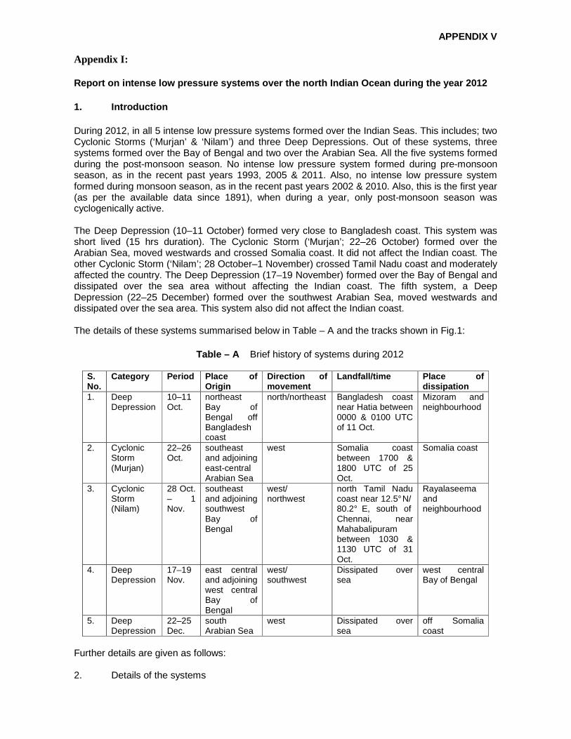
APPENDIX V
Appendix I: Report on intense low pressure systems over the nor th Indian Ocean during the year 2012 1. Introduction During 2012, in all 5 intense low pressure systems formed over the Indian Seas. This includes; two Cyclonic Storms (‘Murjan’ & ‘Nilam’) and three Deep Depressions. Out of these systems, three systems formed over the Bay of Bengal and two over the Arabian Sea. All the five systems formed during the post-monsoon season. No intense low pressure system formed during pre-monsoon season, as in the recent past years 1993, 2005 & 2011. Also, no intense low pressure system formed during monsoon season, as in the recent past years 2002 & 2010. Also, this is the first year (as per the available data since 1891), when during a year, only post-monsoon season was cyclogenically active. The Deep Depression (10–11 October) formed very close to Bangladesh coast. This system was short lived (15 hrs duration). The Cyclonic Storm (‘Murjan’; 22–26 October) formed over the Arabian Sea, moved westwards and crossed Somalia coast. It did not affect the Indian coast. The other Cyclonic Storm (‘Nilam’; 28 October–1 November) crossed Tamil Nadu coast and moderately affected the country. The Deep Depression (17–19 November) formed over the Bay of Bengal and dissipated over the sea area without affecting the Indian coast. The fifth system, a Deep Depression (22–25 December) formed over the southwest Arabian Sea, moved westwards and dissipated over the sea area. This system also did not affect the Indian coast. The details of these systems summarised below in Table – A and the tracks shown in Fig.1:
Table – A Brief history of systems during 2012
S. No.
Category Period Place of Origin
Direction of movement
Landfall/time Place of dissipation
1. Deep Depression
10–11 Oct.
northeast Bay of Bengal off Bangladesh coast
north/northeast Bangladesh coast near Hatia between 0000 & 0100 UTC of 11 Oct.
Mizoram and neighbourhood
2. Cyclonic Storm (Murjan)
22–26 Oct.
southeast and adjoining east-central Arabian Sea
west Somalia coast between 1700 & 1800 UTC of 25 Oct.
Somalia coast
3. Cyclonic Storm (Nilam)
28 Oct. – 1 Nov.
southeast and adjoining southwest Bay of Bengal
west/ northwest
north Tamil Nadu coast near 12.5° N/ 80.2° E, south of Chennai, near Mahabalipuram between 1030 & 1130 UTC of 31 Oct.
Rayalaseema and neighbourhood
4. Deep Depression
17–19 Nov.
east central and adjoining west central Bay of Bengal
west/ southwest
Dissipated over sea
west central Bay of Bengal
5. Deep Depression
22–25 Dec.
south Arabian Sea
west Dissipated over sea
off Somalia coast
Further details are given as follows: 2. Details of the systems

APPENDIX V
2.1 Deep Depression over the Bay of Bengal (10–11 October 2012) 2.1.1 Under the influence of a cyclonic circulation over northwest and adjoining west central Bay of Bengal, a low pressure area formed over the same area on 7 October. It became well marked over northeast Bay of Bengal off Bangladesh coast on 10 morning. Moving northwards, it subsequently concentrated into a Depression at 1200 UTC of 10 and lay centred near Lat 21.0o N/Long. 91.0o E, about 350 kms southeast of Kolkata and into a Deep Depression at 1800 UTC and lay centred near Lat. 22.0° N / Long. 91.0° E . It moved northeastwards and crossed Bangla Desh coast near Hatia (Bangla Desh) between 0000 & 0100 UTC of 11 October and lay centred at 0300 UTC of 11 near Lat. 23.0° N / Long. 91.5° E, a bout 100 kms south of Agartala over Bangla Desh and adjoining areas of Tripura as Depression . It moved northeastwards and weakened into a well marked low pressure area over Mizoram & neighbourhood at 0600 UTC of 11 and further weakened into a low pressure area and lay over Manipur and neighbourhood at 1200 UTC. It became less marked on 12th.
2.1.2 Other features observed The lowest Estimated Central pressure (ECP) was 1002 hPa from 1800 UTC of 10 to 0000 UTC of 11. The maximum estimated mean wind speed was 30 kts during the same period. The lowest observed pressure of 1002 hPa was reported by Chittagong at 0000 UTC of 11, when the system was to the west of Chittagong. Bangladesh reported sustained wind of 22 kts over Hatia, 25 kts over Sandip and 32 kts over Chittagong. The system intensified into a deep depression before landfall, though it was lying very close to coast. The salient features of this deep depression are as follows.
(i) It formed from a remnant of low pressure system from the South China Sea which moved across Vietnam and Myanmar and emerged into the northeast and adjoining east central Bay of Bengal. (ii) It was short lived with the life period of about 15 hrs. (iii) It intensified into a deep depression before landfall, though it was lying very close to coast.
2.1.3 Weather and damage caused System caused extensive damage in Bangladesh taking a toll of 43 human lives. Fairly widespread rainfall with isolated heavy falls occurred over Arunachal Pradesh, Assam & Meghalaya and Nagaland-Manipur-Mizoram-Tripura on 10 & 11. The significant amounts of rainfall (in cms, > 7 cm) are given below:
11 Oct. 2012: Tripura Belonia 9, Bagafa 7. 12 Oct. 2012 Mizoram Lengpui 9. Assam – Matizuri 9, Kajalgaon (AWS) 7.
2.1.4 Satellite and RADAR observations The system was tracked with the help of satellite (Kalpana–1) cloud imageries from 1200 UTC of 10 to 0600 UTC of 11. The maximum intensity of T No 2.0 was reported from 1500 UTC of 10 to 2000 UTC of 10.

APPENDIX V
The satellite imageries showed a developing low level circulation centre associated with increasing deep convection over the region. It was seen as a vortex with T 1.0 from 0300 to 0800 UTC 10. The T number of 1.5 was assigned at 0900 UTC and T 2.0 at 1500 UTC on the same day. The lowest Cloud Top Temperature (CTT) was about –80° C recorded during night of 10. The system was also tracked by DWRs Khepupara, Cox’s Bazar (Bangladesh) and Agartala. The DWR imageries from Agartala indicated that the wind speed was higher in the southern quadrant of the deep depression at the time of landfall. The radial wind of about 25–30 meter per second (48-58 kts) has been reported. It indicates that Agartala experienced 15–20 knots wind at the surface level during 0100–0300 UTC. 2.2 Cyclonic Storm (Murjan) over the Arabian Sea (22 – 26 October 2012) 2.2.1 A trough of low at mean sea level extended from southeast Arabian Sea to south Maharashtra coast on 20 and from Lakshadweep area to south Gujarat Region on 21. Under its influence, a low pressure area formed over southeast Arabian Sea and neighbourhood on 22. It lay as a well marked low pressure area over the same area in the evening of 22. It concentrated into a Depression and lay centred near Lat 11.0° N/Long. 66.5° E at 2100 UTC of 22. Moving westwards, it lay centred near Lat 11.0° N/Long. 65 .0° E, 800 kms east of Amini Divi at 0300 UTC of 23 October and near Lat 11.5° N/Long. 64.0° E at 1200 UTC. It further moved westwards and intensified into a Deep Depression and lay over southwest and adjoining west central Arabian Sea centred near Lat. 11.5° N /Long. 63.5° E at 1500 UT C of 23. Moving slightly west-southwestwards, it lay over southwest and adjoining west central Arabian Sea and centred near Lat. 11.0° N /Long. 59.0° E at 0300 UTC of 24. Moving west–southwestwar ds, it further intensified into a Cyclonic Storm (Murjan) and lay centred near Lat. 10.5° N /Long. 56.5° E, a bout 1750 kms west-southwest of Amini Divi at 1200 UTC of 24 October. Then, it moved westwards and lay at 0300 UTC of 25 October near Lat. 10.5° N / Long. 53.5° E, about 21 00 kms west–southwest of Amini Divi and near Lat. 9.5° N / Long. 51.5 ° E, about 2300 kms west–s outhwest of Amini Divi at 1200 UTC. It further moved westwards and crossed Somalia coast near Lat. 9.5° N / Long 50.8° E between 1700 & 1800 UTC and further weakened into a Deep Depression and lay centred near Lat. 9.5° N / Long. 50.5° E at 1800 UTC of 25. Moving further westwards , it weakened into a Depression and lay centred at 0000 UTC 26 October over Somalia near Lat. 9.5° N / Long. 49.5° E and lay centred at 0300 UTC of 26 October near Lat. 9.5° N / Long. 48. 5° E. It further weakened into a low pressure area over Somalia and adjoining Ethiopia and became unimportant in the evening of 26 October. 2.2.2 Other features observed The lowest Estimated Central Pressure (ECP) was 998 hPa and estimated maximum sustained surface wind of 40 kts at 1800 UTC of 24. A ship with call sign 2FUB4 (13.5/56.6) reported wind 070°/35 kts at 1200 UTC of 24. There was no meteoro logical observation available from Somalia. The system generally moved in a westerly direction. 2.2.3 Weather and damage caused As the system moved away from the Indian coast, no damage was reported due to this system. However, under its influence, widespread/fairly widespread rainfall with isolated heavy falls occurred over Lakshadweep area from 21 to 23, when the system lay as a low pressure area in its vicinity. 2.2.4 Satellite and RADAR observations According to INSAT imagery, a vortex formed over southeast Arabian Sea with T1.0 and lay centered at 1200 UTC of 22 October near lat. 10.00N/ 68.00E. Wind shear was 10-20 Kt at 1200 UTC of 23rd indicating further intensification of the system. The system intensified further with intensity T2.0 at 1700 UTC of 23rd at centre 11.3N/63.3E. Moving in the westerly direction it intensified again into a cyclonic storm with intensity T 2.5 and centre 10.5N/56.5E.

APPENDIX V
System moved rapidly after 0900 UTC of 25th. With speed nearly 30 km/hr and crossed the coast at 1600 UTC of 25th October 2012 at 9.5N/50.6E. The system was of shear pattern till 0600 UTC of 23rd. Then it changed into curved band pattern till landfall of the system. The maximum intensity of the system according to Dvorak’s classification was T 2.5 from 1200 of 24 to 1500 UTC of 25 October 2012.
2.3 Cyclonic Storm (Nilam) over the Bay of Bengal (28 October–01 November 2012) 2.3.1 A low pressure area over southeast Bay of Bengal and neighbourhood concentrated into a Depression over the same area and lay centred at 0600 UTC of 28 near Lat. 9.5° N/Long. 86.0° E, about 730 kms southeast of Chennai. Moving westwards, it lay centred at 1200 UTC of 28 over southwest Bay of Bengal near Lat. 9.5° N/Long. 85.0 ° E, about 650 kms southeast of Chennai. It continued to move westwards and intensified into a Deep Depression and lay centred at 0000 UTC of 29 over southwest Bay of Bengal near Lat. 9.5° N/Long. 84.0° E, about 550 kms southeast of Chennai. Continuing the westward movement, it lay centred at 0300 UTC over southwest Bay of Bengal near Lat. 9.5° N/Long. 83.5° E, about 530 km s southeast of Chennai and at 1200 UTC of 29 near Lat. 9.0° N/ Long. 82.5° E, about 500 kms s outh-southeast of Chennai. It further intensified into a Cyclonic Storm (Nilam) and lay centred at 0300 UTC of 30 over southwest Bay of Bengal near Lat. 9.0° N / Long. 82.0° E, about 500 kms sou th–southeast of Chennai. Further, it moved northwards and lay centred at 1200 UTC of 30 near Lat. 9.5° N/ Long. 82.0° E, about 450 kms south-southeast of Chennai. It moved northwestwards and lay centred at 0300 UTC of 31 over southwest Bay of Bengal near Lat. 11.0° N/Long. 81. 0° E, about 260 kms south-southeast of Chennai. Moving north-northwestwards, it crossed north Tamil Nadu coast near Lat. 12.5° N / Long. 80.2° E, south of Chennai, near Mahabalipuram between 1030 and 1130 UTC of 31 and lay centred at 1200 UTC of 31 near Lat. 12.7° N/Long. 7 9.8° E, about 50 kms south–southwest of Chennai. It moved northwestwards and weakened into a Deep Depression over north Tamil Nadu and adjoining areas of Rayalaseema and interior Karnataka and lay centred at 1800 UTC of 31 October, near Lat. 13.0° N / Long. 78.5° E, about 180 kms west–northwest of Ch ennai. It further moved northwestwards and weakened into a Depression over Rayalaseema and adjoining areas of south interior Karnataka and lay centred at 0000 UTC of 1 November 2012 near Lat. 13.0° N / Long. 77.5° E, about 75 kms, south of Anantpur and at 0300 UTC over south Interior Karnataka, near Lat. 13.5° N / Long. 77.0° E, close to Chitrad urga. It remained practically stationary at 1200 UTC near Lat. 14.0° N/ Long. 77.0° E, near Chitradu rga. Moving slightly northwards it lay centred at 1800 UTC of 1 November 2012 near Lat. 14.5° N/ L ong. 77.0° E. It further weakened into a well marked low pressure area over Rayalaseema and neighbourhood in the morning of 2. 2.3.1 Other features observed The lowest estimated central pressure (ECP) was 986 hPa (post cyclone survey report). The lowest observed pressure was 987.8 hPa at 1040 UTC of 31 October at Kalpakkam (ISRO-AWS, located south of Chennai, (Post Cyclone Survey report)). The maximum estimated mean wind speed was 45 knots. Maximum sustained wind speed of 74 kmph (40 kts) has been reported over Chennai (NBK) at 1110 UTC of 31. The HWSR at Karaikal reported maximum wind speed of westerly/37 kts on 31st October. The salient features of this storm are as follows.
(i) The cyclone followed a unique track with many rapid changes in direction of movement. It initially moved westwards, remained practically stationary for quite some time near Sri Lanka coast and then moved north–northwestwards till landfall. It moved west–northwestwards initially over land upto south interior Karnataka and then moved northwestwards and northwards. The remnant low pressure area moved northeastwards (ii) It moved very fast on the day of landfall, i.e. 31st October 2012.

APPENDIX V
(iii) Over the land surface, the cloud mass was significantly sheared to the northeast of system centre during its dissipation stage leading to rainfall activity over entire Andhra Pradesh and adjoining Odisha. (iv) Maximum rainfall occurred over southwest sector of the system centre and heavy to very heavy rainfall extended upto 300 km.
2.3.2 Weather and damage caused Rainfall at most places with scattered heavy to very heavy rainfall occurred over north coastal Tamil Nadu. Rainfall at most places with isolated heavy to very heavy rainfall also occurred over north interior Tamil Nadu. Also, remnant of the system as a depression and subsequently as a low pressure area caused heavy to very heavy rainfall over Karnataka, Andhra Pradesh and Odisha. Six persons died in Andhra Pradesh. Two houses were fully damaged and 32 houses were severely damaged in Guntur district of Andhra Pradesh. Also, crops in 250 acres of Agricultural as well as 250 acres of Horticultural land were inundated due to heavy rains. Chief amounts of 24 hrs rainfall in cms (7 cm or more) ending at 0830 hrs IST of 01 November 2012 are given below. 31. 10. 2012 Tamil Nadu & Puducherry: Vedaranniyam and Mahabalipuram 13 each, Trangambadi 10, Ennore AWS, Chennai (Nungambakkam), Nagapattinam, Kalpakkam and Tiruvarur 9 each, Madavaram AWS, Thiruthuraipoondi and Nannilam, Kelambakkam and Chennai Airport, Karaikal and Anna University 8 each, Tambaram, Sirkali and Mayiladuthurai, Kodavasal and Muthupet, Marakkanam and Vanur, Chengalpattu, Cholavaram, Puducherry 7 each. Andhra Pradesh: Srikalahasthi 11, Tirumalla 8, Chittoor 7. 01. 11. 2012 Tamil Nadu & Puducherry Yercaud 24, Alangayam 20, Vandavasi 19, Tirukoilur 14, Vanur and Tindivanam 13 each, Gingee, Villupuram and Mylam AWS, Ambur and Tirupattur and Valangaiman 11 each, Sirkali, Kodavasal, Polur, Sethiathope and Tozhudur, Thali, Melalathur and Naduvattam 10 each, Parangipettai, Trangambadi and Kolli dam, Penucondapuram, Needamangalam and Arani 9 each, Chengam and Tiruvannamalai, Mayiladuthurai, Mannargudi, Kolachel, Chidambaram and Cuddalore, Pallipattu and Tirukattupalli 8 each, Aravakurichi, Barur, Hosur, Denkanikottai, Krishnagiri, Uthangarai and Pochampalli, Kattumannarkoil, Chidambaram AWS and Neyveli AWS, Thanjavur, Thiruvidaimaruthur, Kumbakonam, Madukkur, Vallam, Aduthurai AWS and Grand Anaicut, Sankarapuram, Nannilam and Thiruthuraipoondi, Vaniaymbadi, Puducherry, Pappireddipatti and Dharmapuri, Thuvakudi and Pullambadi, Eraniel and Kothagiri 7 each Andhra Pradesh: Vinjamur 16, Tirumalla and Ongole 15 each, Darsi 14, Addanki, Darsi and Kaveli 13 each, Rapur, Bhimunipatnam and Podili 12 each, Venkatagirikota, Kaveli (a) and Venkatagiri Town 11 each, Udayagiri and Avanigadda 10 each, Rajampet and Chittoor 9 each, Thambalapalli and Arogyavaram, Madakasira, Atmakur, Gudur and Nellore 8 each, Srikalahasthi, Punganur and Puttur, Amarapuram, Penukonda and Kadiri, Seetharampuram and Kakinada 7 each, Karnataka: Bagepalli 14, Koratagere 11, Kolar, Rayalpadu, GKVK, Hoskote 10 each, Srinivaspura, Doddaballapura, Nayakanahatti, CN Halli, Madhugiri, Thondebhavi, Gudibande 9 each, MM Hills, Mulbagal, Bangarpet, Bengaluru City, Bengaluru HAL AP, Nelamangala, Hiriyur, Kibbanahalli, Kunigal, Bargur, Chintamani, Gowribidanur 8 each, Panchanahalli, Kadur, Arasikere, Bandipura,

APPENDIX V
Maddur, Malur, TG Halli, Devanahalli, 6 Jagalur, Hosanagara, Chitradurga, Gubbi, Sira, Sidlaghatta, Magadi, Channapatna, Kanakapura, Ramanagara 7 each. 02.11. 2012 Andhra Pradesh Sattenapalle, Salur 14 each, Vijawada 13, Prathipadu, Nandigama, Nuzivid 11 each, Atchampeta, Bobbili, Koderu, Gudivada 10 each, Vizianagaram, Vuyyur, Gajapathinagaram, Addanki, Darsi, S. Kota, Tuni 9 each, Tuni, Kakinada, Ongole, Tiruvur, Chintapalle, Palasa, Bapatla, Araku, Tanuku, Avanigadda, Cheepurupalle 8 each, Guntur, Kaikalur, Bapatla, Mancherail, Podili, Yelamanchili, Tenali, Eluru 7 each. 2.3.3 Satellite and RADAR observations The system was monitored mainly with satellite supported by meteorological buoys, coastal and island observations. It was also monitored by Doppler Weather RADAR (DWR), Chennai and CDR Karaikal. The maximum intensity of the system according to Dvorak’s classification was T 3.0 from 0000 to 1100 UTC of 31 Oct. The system was of curved band pattern till 1800 UTC of 30th October then it changed into CDO pattern. It further intensified (T3.0) at 0000UTC of 31st and continued to move in the same direction to cross the north Tamil Nadu coast around 1200 UTC of 31 October 2012 near12.5E/80.0E. DWR Chennai monitored the system from the night of 29 October, when the cyclonic storm was about 500 km southeast of Chennai. Prominent features of Eye could not be seen persistently. RADAR-echoes in some parts of spiral bands were stronger than the eye-wall echoes on many occasions. Maximum observed reflectivity was around 55 dBZ. The wind field was less symmetric to the eye. Maximum velocity of about 30 mps observed in the cyclone field was associated with the spiral band. Coastal surface observations were recorded on hourly basis, the half hourly INSAT/ Kalpana imageries and every 10 minutes DWR imageries and products were used for monitoring of cyclonic storm. CDR Karaikal monitored the system from 27th Oct. No overlays were fitted for fixing centre of the cyclone. Observations were not recorded from 0000 UTC of 31 due to technical problem. 2.3.4 Performance of RADAR/Telecommunications Channels DWR Chennai: The DWR performance during the cyclone surveillance period had been very good with optimum power output, sensitivity and stability without any trouble except during the period from 0615 to 0710 UTC – Radome door inter lock switch opened due to strong wind. Performance of all telecommunication facilities viz., VPN connectivity, broadband internet connectivity, telephone, and tele-fax was good. CDR Karaikal: RADAR worked satisfactorily during the storm period 26th to 30th Oct. The performance of all communication systems and standby generator was good. 2.4 Deep Depression over the Bay of Bengal (17–19 November 2012) 2.4.1 The well marked low pressure area over east central and adjoining southeast and west central Bay of Bengal concentrated into a Depression over the same area and lay over east central Bay of Bengal at 0600 UTC of 17, centered near Lat. 15.5° N/Long. 90.0° E. It moved slightly northwestwards and intensified further into a Deep Depression over the same region at 0900 UTC and lay centered near Lat. 15.5° N / Long. 89.5° E and near Lat. 16.0° N / Long. 89.0° E at 1200 UTC of 17, about 1000 kms east-northeast of Chennai. It remained practically stationary

APPENDIX V
and lay centred at 0300 UTC of 18 near Lat. 16.0° N /Long. 88.5° E, about 950 kms east-northeast of Chennai. Moving westwards, it lay centred at 1200 UTC of 18 over west central Bay of Bengal near Lat. 16.0° N/Long. 87.5° E, about 800 kms east northeast of Chennai. It moved southwestwards and weakened into a Depression and lay centred at 0000 UTC of 19 near Lat. 15.5° N / Long. 87.0° E, about 750 kms east–northea st of Chennai and near Lat. 15.0° N / Long. 86.5° E, about 700 kms east–northeast of Chennai at 0300 UTC. It moved slightly westwards and lay centred at 1200 UTC of 19 near Lat. 15.0° N/Lon g. 86.0° E, about 650 kms east–northeast of Chennai. It further weakened into a well marked low pressure area over the west central Bay of Bengal at 1500 UTC of 19. 2.4.2 Other features observed It formed from the remnant of low pressure system of south China Sea, which emerged into Bay of Bengal across Thailand. The lowest Estimated Central Pressure (ECP) was 1002 hPa from 1200 UTC of 17 to 1800 UTC of 18. The maximum estimated mean wind speed was 30 knots during the same period. The Maximum Sustained Wind (MSW) was reported as 31 knots by Buoy (23093, 16.5/88.0) at 0900 UTC of 18. The lowest central pressure of 1002.3 hPa was reported by the same Buoy at the same period. The salient features of this storm are as follows:
1. The system moved westwards initially and then west-southwestwards under the influence of the middle tropospheric steering ridge. 2. The system weakened over the sea due to entrainment of cold and dry air from Indian main land in middle tropospheric levels and gradual increase in the vertical wind shear resulting in the northeastward shearing of convection from the low level circulation centre. 3. There existed a well defined low level circulation centre with banding features though the convection was significantly sheared to northeast under the influence of high wind shear on 18th and 19th November.
2.4.3 Weather and damage caused There was no damage due to the deep depression, as it weakened over the sea. Heavy rainfall occurred over Andhra Pradesh, Puducherry and Tamil Nadu due the remnant low pressure area of this depression. The chief amount of 24 hrs cumulative rainfall in cms (5 cm or more) ending at 0300 UTC of date are given below: 22 November 2012 Tamil Nadu & Puducherry Sathanur Dam-10, Padalur-6, Sankarapuram-5, 23 November 2012 Coastal Andhra Pradesh Tada-7 Rayalaseema Tirupati (AP)-14, Perumallapalli and Puttur-7 each, Tirupati and Rajampet-6 each, Pakala-5, Tamil Nadu & Puducherry: Pallipattu-6 24 November 2012 Tamil Nadu & Puducherry

APPENDIX V
Chengalpattu-14, Watrap and Tuticorin-10 each, Usilampatti, Bodinaickanur, Virudachalam-7 each, Coonoor-6, Viralimalai, Maduranthagam, Kothagiri, Ulundurpet, Vellore, Sirkali and Keeranur-5 each, 25 November 2012 Tamil Nadu & Puducherry Manimutharu-14, Thenkasi-12, Shencottah and Maniyachi-6 each, Illuppur-5. 2.4.4 Satellite and RADAR observations The maximum intensity of the system according to Dvorak’s classification was T 2.0 from 0900 of 17 Nov. to 0800 UTC of 18th Nov. The cyclogenesis technique based on Oceansat-2 winds of 15
November showed that the system will develop into a cyclone. The system was away from DWR Chennai range all through its life period. 2.5 Deep Depression over the Arabian Sea (22–25 December 2012) 2.5.1 The trough of low at mean sea level over southwest Bay of Bengal off Sri-Lanka coast lay over Maldives area and adjoining southeast Arabian Sea on 20 and over southeast Arabian Sea and neighbourhood on 21. It organized into a low pressure area and lay over southeast and adjoining southwest Arabian Sea on 22 morning. It rapidly concentrated into a Depression and lay centered at 0600 UTC of 22 over central parts of south Arabian Sea near Lat. 9.0° N and Long. 64.0° E. It moved westwards and lay over southwest Arabian Sea near Lat. 9.0° N and Long. 62.5° E at 1200 UTC of 22. Further moving westwards, it intensified into a Deep Depression and lay over southwest Arabian Sea near Lat 9.0° N and Long . 60.5° E, about 1400 kms west-southwest of Amini Divi (Lakshadweep) at 0000 UTC of 23 and near Lat 9.0° N and Long. 60.0° E, about 1450 kms west-southwest of Amini Divi (Lakshadweep) at 0300 UTC. Moving west-southwestwards, it lay centered at 1200 UTC of 23 near Lat 8.5° N and Long. 57.0° E about 1700 kms west-southwest of Amini Divi (Lakshadweep). Then, it moved westwards and lay centered at 0300 UTC of 24 near Lat 8.0° N and Long. 54.0° E. Further, it moved wes t-southwestwards and weakened into a Depression and lay centred near Lat 7.0° N and Long. 52.0° E a t 1200 UTC of 24 and near Lat 6.5° N and Long. 50.0° E at 0000 UTC of 25. Further moving west-southwestwards, it weakened into a well marked low pressure area over southwest Arabian Sea off Somalia coast on 25 morning and subsequently became unimportant. 2.5.2 Other features observed The lowest Estimated Central Pressure (ECP) was 1002 hPa from 0000 UTC of 23 to 1100 UTC of 24. The maximum estimated mean wind speed was 30 knots. The Maximum Sustained Wind (MSW) was reported as 23 knots by ships A8KX4 at 0600 UTC of 22 and by A8ZE4 at 1200 UTC of 24. The lowest central pressure of 1007.2 hPa was reported by the ship 2FUB2 (0.4/58.7), Buoy 23494 (8.4/73.0) and Amini Divi at 1200 UTC of 22. 2.5.3 Weather and damage caused No damage was reported due to this system. 2.5.4 Satellite and RADAR observations The maximum intensity of the system according to Dvorak’s classification was T 2.0 from 0000 of 23rd Dec. to 1200 UTC of 24th Dec. The cyclogenesis technique based on Oceansat-2 winds did not show any sign of formation of cyclone.

APPENDIX V
Fig.1: Tracks of Cyclones and Depressions over North Indian Ocean during the year 2012

APPENDIX V
Appendix II Review of action taken on the final report of the 39th session of WMO/ESCAP Panel on Tropical Cyclones held during 5 – 9 March 2012 at Nay Pyi Taw, Myanmar Para No. Progress 2.6 May be obtained from DDGM (NWP), New
Delhi 3.1.4 to 3.1.6, 4.1, 6.2 May be obtained from DDGM (S)/CWD, New
Delhi 4.1, 5.4.10, 8.8 May be obtained from DDGM (O), New Delhi

APPENDIX V
Country Report of the Members – Maldives
TheCyclone Season – 2012
Low pressure systems/ depressions and cyclonic activity “Murjan” (18 to 21 Oct 2012) and “Nilam” (21 to 31 Oct 2012) resulted severe weather phenomenon in Maldives and caused damages at many islands. The drivers, characteristics, impacts of severe weather system are discussed in the following section. 1. Weather Drivers’ Features
Inter Tropical Convergence Zone (ITCZ), Sub Tropical Westerly Jet (STWJ), Sub Tropical
Ridge are the major drivers for the severe weather event. During October 23rd to 31st Madden Julian Oscillation (MJO) with its enhanced activity in Indian Ocean region also aggravated severe weather conditions. 2. Impact of weather drivers on synoptic features
Under the influence of weather drivers described above, two lows were seen 20 October
2012 18 UTC and 27 October 2012 18 UTC which caused the heavy rainfall episodes during 21 to 31 October 2012. Low seen on 20 October 2012 18 UTC near southern Maldives caused heavy rainfall during 22 October 2012 in southern and central part of Maldives. This low intensified and moved west of Maldives and manifested as cyclone ‘MURJAN’ and made a land fall on Somalia Coast on 25 October. Further, another Low developed near northern Maldives during 27 October 2012 18 UTC brought heavy rainfall episodes in Northern part of Maldives. 3. Manifestation of Weather features on Maldives
Under the influence of synoptic scale weather systems described above the Maldives
experienced 82 mm of rain to GAN - ADDU CITY on 22nd October and since then the severe weather system remained active over the country. It became more enhanced on 24th October by causing heavy rain over southern and central atolls. KADHDHOO – LAAMU ATOLL received 119 mm of rain on that day. The trough further oscillated south to central to north and rain showers were distributed through many atolls during next few days.
Rainfall at KADHDHOO – LAAMU ATOLL and HANIMAADHOO – HAADHAALU were 62 –
65 mm on 27th followed by 115 and 145 mm recorded at HANIMAADHOO on 29 October and 30 October, respectively. The October monthly mean rainfall at Hanimaadhoo is 199 mm. Even a much higher intensity/ amount of rainfall is expected in its neighbourhood. HOARAFUSHI and NOLHIVARANFARU reported most destruction due to floods on the same day. Considering the impact level and recorded rainfall nearby (Hanimaadhoo&Kelaa 128mm), Maldives Meteorological Service estimate 200mm of rainfall for Hoarafushi’s flooding. In the south, KAADEHDHOO – HUVADHU ATOLL recorded 120 mm on 31 October 2012. The October monthly mean rainfall at Kaadehdhoo is 253 mm.
As the trough gets intensified the low level winds begin to pick-up from 28th October
onwards. Strong winds were prevalent to central atolls and approximately 7 hours of steady 20knot wind were reported at the National Meteorological Centre for 28th October. The strong wind duration was prolonged further until end of October and part of southern atolls also reported strong wind on 31st October. The first tornado hit HULHUMEEDHOO – ADDU CITY on the afternoon hours of 29th October and the second one around 6 pm in FEYDHOO – ADDU CITY. Both funnel clouds brought successive damages and huge losses.
The flood event in Fuvahmulah – 6 November 2012

APPENDIX V
The Inter Tropical Convergence Zone (ITCZ) shifted southwards close to equator on 5th November and very intense convective clouds formed over southern Maldives. Torrential rain and severe flooding were reported in Fuvahmulah measuring 132 millimeters on 6th November 2012.
4. Forecasting Global Numerical Weather Production products
Products of various numerical weather prediction (NWP) models and dynamical-statistical
models received through internet. RIMES Experimental Forecast
RIMES shared its experimental forecast on 29th October 2012 for NILAM Cyclone about
the characteristics of the cyclone, The landfall of Cyclone NILAM on 31October 2012 was well predicted by RIMES WRF experimental forecast. The six hourly forecast simulations for wind speed and rainfall parameters were shared to MMS. 5. Damages
The observed impacts during the period reported by Atoll/ Island Councils, National
Defense Force (MNDF), Police, NDMC and media were huge and fairly widespread affecting many households, crops, and water sewerage systems.The cost of the damage caused by flooding and tornado are expected to rise to millions. Meteorological Component
Upper Air Observation
Radio-Sonde observations at the Meteorological Office, Gan (WMO # 43599) were done until March 2012 and thereafter due to shortage of consumables Radio Sonde observations were terminated. No observations were done at Male’ (WMO # 43555) during 2012 due to unavailability of equipment and consumables. As the location of Maldives in the Indian Ocean happens to be a data sparse area in which shifting of ITCZ and phases of MJO take place. Therefore, upper air observations from both Male’ and Gan are very important to entire meteorological community in the region and globe. Maldives urge assistance from donors and Panel Members to consider rebuilding our upper air observation network. Surface, Rainfall and AWS observations
Maldives has 5 meteorological stations all are manned 24 hours, both synoptic and aviation
reports are made on all five stations. Only one of them is categorized additionally as upper-air station. Total of 23 Automatic Weather Stations (AWS) has been installed and are in operation.

APPENDIX V
However sustaining of these AWS have become difficult due to financial limitations year after year. As a result, only 9 stations are sending out data to the National Meteorological Centre at present.Across the country, Maldives has 7 rainfall stations which measure only accumulated rainfall for 24 hours and readings are collected at 0300UTC for national use only. Meteorological Satellites.
Digital Meteorological Data Dissemination (DMDD) system donated by India Meteorological
Department (IMD) receives WMO coded GTS data, half hourly cloud imagery from KALPANA and Fax charts in LRIT/HRIT format. With all of its features,DMDD helps forecasters to do more precise predictions. However, this system is facing signal loss therefore nothing has been received during 2012. The High Resolution Satellite Image Receiving System GEOSAT 500 has stopped functioning since 2010. It is required to pay a considerably high amount to the manufacturer to renew its service agreement.
An integrated satellite receiving system generously donated by China Meteorological Agency was installed on 25 October 2012. This CMACast system receives Satellite imageries from FY2E and FY2D series of Chinese geostationary satellites at an interval of 30 minutes.
Another component of this system is the application software MICAPS (meteorological data
analyzing system) which enables to display satellite pictures, surface & upper air data and NWP products and overlay different products and analysis of various weather phenomena. Doppler Weather Radar
Doppler Weather Radar received as part of Multi-hazard Early Warning System has been repaired in 2011. However, it needs further calibration of equipment by a professional and local technicians are unable to do the job. MMS have begun the process of hiring an expert to bring this system to normal. Numerical Weather Prediction
The system which runs WRF model gives problems time to time as the hardware become old and it is impossible to upgrade them due to financial crisis. Maldives Meteorological Service continues to use NWP output provided by RIMES, ECMWF, IMD and other web based NWP products. NMC’s Global Telecommunications System (GTS)
MESSIR-COMM message switching system developed by COROBOR is a TCP/IP based multi-channel communication link that is capable of handling vast amount of data. Although this GTS is in operation throughout 2012, Maldives received many complains from other countries and GCOS of not receiving our SYNOP, TEMP messages through GTS. Likewise, the monthly CLIMAT report sent via GTS is also reported not received by users. Efforts have been made in late 2011 – 2012 in consultation with RTH New Delhi in this regard and still this matter needed to be taken care of and work closely to arrive at a sustainable solution. Disaster Prevention and Preparedness Component
Maldives Meteorological Service is mandated for issuing advisories and warnings related to meteorological, hydrological, tectonic and oceanographic disasters. To accomplish these tasks, MMS has prepared the Standard Operating Procedures (SOP) to act upon any likely event of meteorological, hydrological, tectonic and oceanographic disasters. MMS acquired a High Resolution Satellite Image Receiving System, Doppler Weather Radar, number of Automatic Weather Stations, broadband and short-period seismometers within the framework of establishing a National Multi-Hazard Early Warning System.

APPENDIX V
Warnings and Advisories
During 2012 Cyclone Season, the severe weather was monitored locally through the 5 Met. Stations, 9 Automatic Weather Stations and SATELLITE image receiving system. Products of various numerical weather prediction (NWP) models and dynamical-statistical models received through internet were utilized to predict the variations in local atmosphere. Experimental forecast from RIMES and Bulletins from RSMC – New Delhi were used to predict the intensity and track of the Bay of Bengal System. MMS issued 42 WHITE Alerts, 7 YELLOW Alerts and 1 RED Alert during 2012 Cyclone Season. Apart from these, interviews, briefing to sea travelers, fisherman, national defense, police, NDMC and various media were conducted.
MMS in collaboration with RIMES convened a Monsoon Forum during 2012. This forum serves as a national platform for its dialogue process between forecast providers and users, with the following objectives:
1. Ensure that forecasts/ warning information products, including their uncertainties and limitations, are communicated to and understood by users.
2. Encourage the use of forecasts to mitigate risks in climate-sensitive sectors, including, but not limited to agriculture, water resources, disaster management, and health.
3. Receive user feedback for improving usability of forecast products. 4. Provide a platform for inter-agency coordination of policies, and sectoral plans and
programs for dealing with potential impacts of hydro-meteorological hazards. 5. Provide a platform for long-term process of understanding risks posed/opportunities
brought about by past, current, and future climate.
The first forum convened in Fuvahmulah proved as a success when the November 2012 flood event occurred there. Training and Support
To build the capacity of MMS further and in accordance with the mandate and action plan, we urgently need to train our personnel. Coordination is required in Meteorology, Aviation, and Satellite Met, WRF/WAM, climate, tsunami propagation and storm-surge modeling.
Maldives is in need of financial and technical assistance in strengthening its observational
network, especially upper air observation, Automatic Weather Station and Radar Meteorology. Research
Maldives is hosting a Collaborative Climate Research in its Addu City – A scientific Project in the Indian Ocean to better understand Global Climate & Weather Systems – Endorsed by World Climate Research Programme.
The Madden-Julian Oscillation (MJO) is a 30 to 90 day tropical weather cycle that alternates between large, strong rain storms and relatively quiet periods, moving from the Indian Ocean eastward to the Pacific Ocean. The MJO no tonly plays an important role in local weather in the tropics, affecting regional monsoon rains, but also impacts weather and climate in other parts of the world. Improved understanding of this important event will help short- and long-term weather forecasting and climate predictions across the globe. Dynamics of the Madden-Julian Oscillation (DYNAMO) study is being conducted from October 2011 – March 2012,which is the most frequent time for the onset of the MJO.
DYNAMO will provide researchers with vital observations of the MJO, a poorly
understood phenomenon, particularly during the initiation phase. The results will help researchers to more accurately forecast the weather and climate of the equatorial Indian Ocean and around the world. Large-scale weather events, such as the MJO, create pulses that have direct effects on regional weather patterns around the world. During the field campaign land, ocean

APPENDIX V
and atmosphere based observations will simultaneously be taken by using various radars, balloon launches, research vessels and research airplanes.

APPENDIX V
Country Report of the Members – Myanmar
The impact of tropical cyclones Introduction
During 2012, the formation of total Low Pressure Areas over the Bay of Bengal were (10) and (2) intensified to depression and one become cyclonic storm “Nilam” which crossed to the southern Coast of India, near Chennai. One Low Pressure Area (LPA) occurred in July, (3) LPA formed in August, (2) LPA occurred in September, (1) depression and (1) Cyclonic Storm “Nilam” occurred in October and (1) Depression and (1) LPA formed in November. Storm frequency occurred in 2012 is lowest since 2011 but the rainfall amount of in the whole country are normal condition.
Depression and Cyclones occurrence in 2012 October 7th to 12th Tropical Depression
According to the observation at 1200Z, a low pressure area has formed over Northwest Bay
and adjoining west central Bay of Bengal. The LPA intensified into a Depression on 11th October at 2300Z and crossed to Hatiya (Bangladesh) at 0630Z and remained practically stationary as land depression. That land depression became unimportant near Manipur (India) on 12th October at 0000Z. Some significant features of about Tropical Depression are as follow:
(a) The tropical depression formed during withdrawing of southwest monsoon (b) The tropical depression crossed land rapidly (c) The tropical depression persisted over the land as land depression and became
unimportant.
October 27th to November 1st Cyclonic Storm
According to the observation at 0700Z, a low pressure area formed over southeast Bay of Bengal. It was further intensified into a tropical depression at 1200Z on 28th October and centered at about (400) miles southeast of Chennai (India). The tropical depression intensified into a Cyclone “Nilam” on 30th October at 0800Z and centered at about (250) miles southeast of Chennai (India). On 31st October, it crossed South coast of India and became unimportant on 1st November at 2300Z. Some significant features of about Tropical Depression are as follow:
(a) The cyclone “Nilam” formed after the southwest monsoon withdrawal from the whole country by (16) days.
(b) “Nilam” is only one naming storm of Bay of Bengal in 2012. (c) It was not strong too much compare with last year cyclones. (d) The tropical depression persisted over the land as land depression and become
unimportant.
November 14th to November 23th Tropical Depression
According to the observation at 1200Z on 14th November, a low pressure area formed over
southeast Bay of Bengal and intensified into a depression at 0900Z of 17th November over south Bay and adjoining central Bay near latitude 15.5N and longitude 90E, about (250) miles West of Pathein(48094) and about (320) miles Southwest of Kyaukpyu(48071). It moved Southwestwards at 0000Z on 19th November, about (420) miles West of Pathein and about (400) miles Southwest of Kyaukpyu and weakened into a low pressure area in the morning of 20th November. Some significant features of about Tropical Depression are as follow:

APPENDIX V
(a) The depression occurred after the southwest monsoon withdrawal from the whole country by (1) month
(b) It stayed very long time as a depression in the Bay (c) The depression did not cross the land and weakened into a LPA in the southwest Bay
and adjoining west central Bay of Bengal.
Salient Points for 2012Tropical Cyclone Season over Bay of Bengal
(a) As the past (21) years (1991-2011), none of the Storm formed in the Bay of Bengal of January, February and March and other months are occurred storms. Only (3) Depression and Cyclonic Storm formed during the season of 2001 and 2012.
(b) The tropical depression crossed land rapidly on 7th October. No new rainfall recorded for that depression but noteworthy amount of rainfall recorded were (183)mm in Maungdaw (48061) on 11th October and (152)mm in Homalin(48010) on 12th October.
(c) Out of 2 Depression, one further intensified into a cyclone “Nilam” on October. A cyclonic storm “Nilam” is only one naming storm of Bay of Bengal in 2012 and crossed southern Coast of India. During that time, no maximum rainfall occurred in Myanmar.
(d) Phyarpon(48101) observed New rainfall recorded data associated with Low Pressure Area that formed over Andaman Sea and adjoining Southeast Bay of 30th November.
Meteorological Component 2012 Weather Summary
During the period of Pre monsoon, there was no cyclone form over Bay of Bengal. Southwest monsoon set in to Southern Myanmar (18) May and retreat from the whole Country (11) October 2012. Total monsoon period was observed (127) days. During the mid monsoon period, the monsoon intensity was moderate to strong with regional heavy falls in lower Myanmar areas and isolated heavy fall in Upper Myanmar areas .Out of (10) low pressure areas, (3) intensified further into Depression and (1) intensified into very Cyclonic storm “Nilam”. October Depression crossed between Bangladesh Coasts near Hatia. 2012 experienced for La Nina but not severely affect. 2012 New Records of Meteorological Parameters
During the year 2012, average annual rainfall for whole country was about normal. Heaviest annual rainfall was observed (262.09) inches at Dawei station (48108) and lowest annual rainfall was (14.64) inches at Chauk station (48052). The country’s (24) hour heaviest rainfall of (16.61) inches was observed at the Maungdaw (48061), Northwestern Coastal areas of Rakhine State on 27 June 2012. The highest maximum temperature during the summer was (46.4 °C) at Chauk station (48052) on 19 May, 2012. (12) stations set the new rainfalls recorded during 2012. 2012 summer and Winter Temperature
In summer season, the day temperatures were below normal in Upper Myanmar areas, about normal in central and lower Myanmar areas for 1st decade of March but above normal in northwestern part of Myanmar for 2nd decade. It was above normal in the whole country except Deltaic areas for 3rd decade. In April, the day temperatures were above and about normal in the whole country except extreme northern Myanmar areas. It was generally above normal in the whole country except eastern Myanmar areas for 1st & 2nd decade of May. In this period, the new recorded maximum temperature was observed in central Myanmar areas.
In winter season, the night temperatures were generally above normal in the whole country
for the 1st & 2nd decade of January but below normal for 3rd decade. In February, the temperatures

APPENDIX V
were below normal in Upper Myanmar for 1st decade, about and above normal in the whole country for 2nd and 3rd decade. It was below normal in northwestern part of Myanmar but about and above normal in the whole country for November. In December, the temperatures were about normal in the whole country for 1st decade but below normal in Eastern and Deltaic areas in 2nd decade. It was about and above normal in the whole country except western Myanmar areas in 3rd decade of December.
Improvement/Upgrading of Meteorological Facilities
Multifunctional Satellite Image(MTSAT) ground receiving system and related computer facilities, JMA GSM GRIB data, soft wares, JMA storm surge model, one high accurate digital barometer, technical guidance methods were provided under the Japan International Cooperation Program’s Improvement of Storm Forecasting Project (2010-2012). GTS Message Switching System is operating normal condition. Recently DMH Head Office Nay Pyi Taw and RTH New Delhi, RTH Bangkok were linked. Procedures are being undertaken to test transmission via new Japan Meteorological satellite. Upper Air Observation System is still single observation station and need to establish more observatories. (10) Location specific Meteorological information like EPSgram, provided by WMO and ECMWF, were utilized for daily weather forecast, and WMO/RAII City Weather Forecast from Hong Kong Meteorological Services provided Meteogram for (12) cities. Meteorological services of DMH were very supported by these tools, on job training to the daily weather forecast and severe weather analysing and forecasting. GFS GRIB2 data based WRF Model is operating once per day and (30) images are updated and posed on DMH Website daily for agriculture, general public, transportation, etc. The WRF Modelling system is the first NWP activities and to be carried out for Regional Climate Model in near future. Meanwhile, Norwegian government’s technical assistance for the development program of weather forecasting including NWP based DIANA Model will be collaborated in March 2013. Disaster reduction activities
Main responsibility of Department of Meteorology and Hydrology (DMH) is to provide early warning to the higher authorities, local government, and disaster risk reduction relevant agencies, media, INGOs, Myanmar NGOs and general public. DMH officials actively cooperate with National Disaster Management agencies for Hyogo Framework of Action Plan preparation, disaster risk reduction activities, workshops and training program to implement community awareness, risk reduction, public education programme and officials interviewed with State run TV and mass media about public awareness program, existing weather and climate phenomenon and role of early warning, adverse weather phenomenon in Myanmar.
National Monsoon Forum jointly organized with twice annually with the collaboration with
regional partner agencies, FAO, RIMES and stakeholders for Seasonal Climate Outlook and reviewed hydro-meteorological disasters. Director General of Department of Meteorology and Hydrology comprise as a member National Advisory Committee of Disaster Prevention and Preparedness.
Meteorological articles about current weather events, significant weather, and updated
information of La Nina were published in State Newspapers, Ministry of Transport’s Journal and other private Journals. DMH established a link first time in 2011 with Myanmar RADIO for live radio broadcasting about early warning and advisories while depression approaching Myanmar Coastal areas. Latest position, expected weather, suggested actions were informed to general public effectively.
DMH owned weather studio for effective communication with clear, understandable weather
information and DMH official website www.moezala.gov.mm and (2) automatic weather answering phones fulfil early warning system with updated warning and news. Early Warning decision making processes were accomplished with valuable support and close cooperation with WMO and its Regional office, RSMC, New Delhi, WMO GTS, GFS forecast, CIMSS’s analysis, WNO SWFDP

APPENDIX V
products and neighbouring NMHSs for the early warning, training and other technical support for Myanmar. Hydrological Component Occurrences of Floods in 2012
Department of Meteorology and Hydrology (DMH) is the responsible agency for flood
forecasting and warning in the country. There are eight major rivers in Myanmar, which are Ayeyarwady, Chindwin, Sittoung, Thanlwin, Bago, Dokehtawady, Shwegyin and Ngawun rivers. DMH maintains 27 Hydrological Stations and 44 Hydro-meteorological stations and issues flood forecasts for 30 stations in Myanmar. During 2012, there were floods at downstream of Ayeyarwady river, upstream of Chindwin river, Thanlwin river, Sittoung river, Bago river, Shwegyin river and Ngawun river. These floods except Madauk of Sittoung River, Shwegyin of Shwegyin River and Hpa-an of Thanlwin river were normal flood, which the flood magnitude were about 2 to 4 feet and flood duration was about 2 to 9 days.
In August, the big flood occurred at Madauk of Sittoung river and this flood was the second highest record during last 47 years and at Shwegyin of Shwegyin River was the third highest during last 48 years. Similarly, the flood occurred two times at Hpaan of Thanlwin in 2012 and the first flood wave exceeded the danger level by 4.5 feet and stayed about 22 days. Due to this flood inundated the wards of 1, 2, 3, 4, 5, 6, 7 and the neighboring low land area. DMH has issued (23) flood warnings and (61) flood bulletins during 2012 flood season. Hydrological services
Hydrological Division of DMH is responsible for issuing daily river forecast and flood
forecast along 8 major rivers: Ayeyarwady, Chindwin, Sittaung, Thanlwin, Dokehtawady, Bago, Shwegyin and Ngawun. Whenever warnings are issued from River Forecasting Section (RFS) of D.M.H, the message is sent to the respective stations by telephone or Single Side Band (SSB) transceiver. As soon as head of the station receive the message of warning, he immediately inform the local authorities and other related departments in order to carry out the necessary action. At the same time the warnings are disseminated through the radio and television as well as through the Newspaper for general public.
RFS of D.M.H is using both simple and advanced techniques for issuing flood warning and
bulletin to the users and public, and is also applying empirical models based on single and multiple regression analysis for forecasting peak flood level along Ayeyarwady and Chindwin rivers. The lead time for issuing flood warning is about one to two days for short range forecast and about five days for long range forecast, especially for deltaic area of Ayeyarwady. Flood usually occurs in each and every year at one river system or another. The occurrences of floods in Myanmar can be generally expressed as 6% in June, 23% in July, 49% in August, 14% in September and 8% in October. According to the previous 47 years’ observation, severe flood years were noted as 1973, 1974, 1976, 1979, 1988, 1991, 1997, 2002, 2004 and 2007.
Regarding the training course for Hydrology, Initial Course of GIS (1 September to 1
November 2012), the hydrological Grade (I) course (10 December, 2012 to 9 January 2013) and grade (II) course (4 February to 7 March 2013) were held at Department of Meteorology and Hydrology in order to develop the knowledge of new generation of DMH and capacity development.
Discharge Measurement
In 2012, the new instrument for discharge measurement, which is River Surveyor, was
purchased to measure the discharge. In order to provide runoff data, discharge and sediment discharge measurements are carried out every year at four sites in the selected three rivers by Hydrological Division, Upper Myanmar Division and Lower Myanmar Division. At the year 2012,

APPENDIX V
measurements of discharge, sediment discharge and bed profile were implemented at Nyaung U and Myinmu for Ayeyarwady river, Mingin for Chindwin River and Bago for Bago river.
Acid Deposition Monitoring
As a national monitoring center of EANET (Acid Deposition Monitoring Network in East
Asia), DMH is responsible to monitor not only Wet deposition of rain water but also Dry deposition of air concentration in Yangon. The water quality Laboratory of DMH has been able to analyze not only the ion contents such as Cation NH4
+, Na+, K+,Ca2+,Mg2+ and Anion SO42-, NO3
-,Cl- for dry deposition but also the ion contents such as Cation NH4
+, Na+, K+,Ca2+,Mg2+ and Anion SO42-, NO3
-
, Cl- and measured pH and EC for wet deposition. In November 2012, the three experts from Asia Center for Air Pollution Research –
ACAP(former ADORC) have visited to the laboratory of DMH and they implemented the activities in accordance with the objectives of the mission: to exchange views and information on the data quality on the acid deposition monitoring of EANET in Myanmar, to exchange views and information on the soil and vegetation monitoring in Myanmar as Future activities of EANET, to confirm the implementation of Filter Pack sampling and other,
The Scientific Advisory Committee (SAC) and the Intergovernmental Meeting (IG) on the
Acid Deposition Monitoring Network in East Asia (EANET) were held these section (SAC-2012) and (IG-2012) as co-host Country during the period of 20-28, November 2012 in Yangon, Myanmar, DMH, Laboratory summit the Annual Monitoring Data on Wet & Dry Deposition to the ACAP (Network Center) in the end of June of year. And also, summit the Inter-laboratory Comparison Project-2012 on wet & dry deposition data to the ACAP (Network Center) the end of February of year.
GIS application in Hydrology
GIS application in Department of Meteorology and Hydrology is initial stage at the present.
The government has invested about 100 million Kyats for establishment of GIS application in DMH. In 2012, Flood Hazard Map for Homalin City was produced by the technical assistant of Geoinformatic Center of Asia Institute of Technology and financial assistant by Japan Aerospace exploration Agency. During 2012, DMH has developed flood simulation by using IFAS for small catchments and ungauged catchments. DMH is also implementing geomorphological parameters of Myanmar river systems. Disaster Prevention and Preparedness Component Introduction
Myanmar, one of the disaster prone countries in the world, is a member of ASEAN Committee on Disaster Management (ACDM). Here, Relief and Resettlement Department (RRD) is a focal point of ACDM. Moreover, Myanmar is a signatory country to the ASEAN Agreement on Disaster Management and Emergency Response (AADMER), and also joined World Conference on Disaster Reduction (WCDR) in Kobe, Japan in January 2005. Therefore, Myanmar has to do follow up actions under Hyogo Framework for Action adopted by WCDR. National Mechanism for Disaster Management in Myanmar
In Myanmar, the lead organization for Disaster Management is Myanmar Disaster
Preparedness Agency (MDPA) which was reformed according to the Notification No.(23/2011) dated (20.4.2011) of the President Office of the Republic of the Union of Myanmar. In MDPA, the Union Minister for Social Welfare, Relief and Resettlement is taking as a Chairman, the deputy Ministers for Defence and for Home affairs are as Vice Chairmen, Deputy Minister for Social Welfare, Relief and Resettlement as Secretary and Director General for Relief and Resettlement as Joint-secretary, and it comprises of 8 members.

APPENDIX V
Under MDPA, there is Myanmar Disaster Preparedness Management Working Committee
and (14) Sub-Committees. Myanmar National Search and Rescue Committee(MNSRC) was also constituted and in which Chairman is Union Minister for Home Affairs, Vice Chairmen are Union Minister for SWRR and for President office, Secretary is chief of Myanmar Police Force and Joint-Secretary is Head of Police Officers, and comprises of 20 members. Roles and Responsibilities for all these Agency, Committee and Sub-Committee have been already designed and ready to function.
Under the lead of National Disaster Preparedness Agency, Disaster Preparedness
Committees have been organized at the State/ Region/ District/ Township level and up to Village Tract level. All of these Committees at different levels have to follow the designed functions of before/during and after disaster. Functions of Relief and Resettlement Department for Disaster Risk Reduction
Relief and Resettlement Department have implemented with effort Disaster Risk Reduction activities such as Preparedness (Prevention), Response and Rehabilitation.
As part of Preparedness (Prevention), for the sake of effective public awareness, Relief and
Resettlement Department has conducted Training of Trainers (TOT), Disaster Management Courses (DMC), Educative Talks in village level, and Workshops in collaboration with State and Regional Authorities, related Departments, UN, INGO and NGO. Moreover, with the intention of public widely know about natural disasters, RRD has produced and published pamphlets and posters into the community.
In order to rapidly provide relief items to the affected people in emergency situation, (8)
kinds of relief items such as longyi for man, longyi for woman, blanket, pot, bowl, scraf, T shirt and Caborlit soap for (61500) households have been stand by stored at every RRD Ware houses in every State and Region. Moreover, RRD has provided shelters to the victims for their temporary living.
RRD has provided (50000) Kyats for per dead child (under 18 years), (100000) Kyats for
per dead adult (18years and above), (50000) Kyats for per damaged house, (60000) Kyats for per damaged religious building. For the current nutrition of victims, RRD has provided (4.875) pounds of rice to per affected adult (12 years and above), (2.438) pounds of rice to per affected child (under 12 years). RRD had also provided a robe to each affected monk and nun.
Then, in collaboration with other related Departments, UN, INGO and NGO, RRD have
implemented such rehabilitation activities as providing MEC zincs for building houses, infrastructure, livelihoods, constructing cyclone shelters, school cum shelters, hill locks, etc in the affected areas.
For Nation-wide awareness, on every October(13), Relief and Resettlement Department
under Ministry of Social Welfare, Relief and Resettlement have annually celebrated International Day for Disaster Risk Reduction at Myanmar International Convention Centre, Nay Pyi Taw since 2010 in collaboration with UN, INGO and NGO.
For effective early warning system, Relief and Resettlement Department have collaborated
with Meteorology and Hydrology Department, General Administration Department, other related Departments and Organizations to widely spread early warning and weather or disaster information into the community through fax and phone. Relief and Resettlement Department had also already drawn Flood Plans and published to every State and Region.
Achievement in Disaster Risk Management Policy and Practice In collaboration with other related Departments, Organizations, Relief and Resettlement Department had already drawn Standing Order on Natural Disaster Management (2009), Disaster

APPENDIX V
Management Law (2011), Hazard Profile, Institutional Arrangements for Disaster Management in Myanmar, Guideline for Township Disaster Management, and Myanmar Action Plan on Disaster Management (MAPDRR) has already endorsed and now the priorities of MAPDRR have been implementing. Moreover, Relief and Resettlement Department, Planning Department and Asian Disaster Preparedness Centre (ADPC) have been jointly organizing the National Training Course on Mainstreaming DRR into Development Planning. Disasters happened in Myanmar and RRD’s Functions during 2012 During 2012, (422) times of disaster had happened in Myanmar. So, there were (190890) affected persons, (127) dead persons, (121) injured persons, (486.58) Million (Kyat) for damage and loss. Relief and Resettlement Department had already provided (444.09) Million (Kyat) for all The most famous disasters in 2012 are Rakhine conflict, flood and Thabeik Kyin earthquake. Rakhine conflict happened two times. On (8.6.2012), the conflict firstly happened in Sittwe, Myaut U, Kyaut Taw, Minpya, Pauk Taw, Maung Taw, Yathae Taung, Buthi Taung, Yanbyae and Ponena Kyune. In this first time, there were (89) dead persons, (124) injured persons, (5338) damaged houses. So, Relief and Resettlement Department opened (19) relief camps in Rakhine. On (21.10.2012), the conflict secondly happened in Myaut U, Kyaut Taw, Minpya, Pauk Taw, Yathae Taung, Yanbyae, Kyaut Phyu and Myaybon. In this second time, there were (111) dead persons, (144) injured persons, and (5351) damaged houses. So, Relief and Resettlement Department opened (22) relief camps in Rakhine. During 2012, July to September, Myanmar was extremely striken by flood especially in Kayin, Sagaing, Tanintharyi, Nay Pyi Taw, Bago, Mandalay, Mon, Yangon, Shan and Ayeyarwaddy. In this flood, there were (139319) affected persons and altogether (167.297) Million (Kyat) had already provided. Thabeik Kyin earthquake happened on (11.11.2012) with (6.8) Richter scale in Sagaing and Mandalay. In this earthquake, there were (18) dead persons, (116) injured persons, (2496) damaged houses, (1633) other damaged infrastructure. So, Relief and Resettlement Department had already provided (44.426) Million (Kyat).
During 2012, for Capacity Generating of officers from related Departments who have participated in Disaster Management, Relief and Resettlement Department could have already conducted (7) times of Capacity Generating Trainings for Disaster Management in every State and Region such as Kayah, Kayin, Chin, Bago, Magway, Mon and Shan, and then also (46) times of duplicate trainings in every state and region, and (52) workshops. Moreover, Relief and Resettlement Department could have provided Disaster Management lecture at the trainings of Central Institute of Civil Services, and other trainings. GIS and Remote Sensing Trainings could also have been conducted in Nay Pyi Taw in collaboration with UN-SPIDER and ADPC. During 2012, altogether (89700) pamphlets and (13755) posters had already distributed in all these trainings, workshops, and also to the public.
In 2012, October (13), Relief and Resettlement Department under Ministry of Social
Welfare, Relief and Resettlement could celebrate 3rd Commemoration of International Day for Disaster Risk Reduction at Myanmar International Convention Centre, Nay Pyi Taw. At this commemoration, Honorable Vice President, Dr. Sai Mauk Kham delivered speech and High representative of UN delivered remarks. Moreover, here, like former times, Public participated Tsunami Drill video for (10) minutes which were conducted in Tsunami prone areas such as Ayeyarwaddy Region have been shown, and the competitions of essay, article, poem, and cartoon for Disaster Management have also been held, and rewarded prizes to the winners. Ways Forward Relief and Resettlement Department has objectives to implement the following projects:

APPENDIX V
- to establish Disaster Management Training School in Hinthada township of Ayeyarwaddy Region
- to establish Emergency Operation Centre - to construct (45) Cyclone Shelters in Ayeyarwaddy Region - to build hill locks in Pharpone and Laputta Districts - to implement assessment and research activities - to implement community based Disaster Risk Reduction Conclusion Relief and Resettlement Department under Ministry of Social Welfare, Relief and Resettlement has been implementing its responsibilities with effort in line with its objectives in order to Myanmar be a resilience and sustainable development country in collaboration with related Departments, UN, INGO, NGO. Like the international countries, Disaster Management is priority for Myanmar. Therefore, as RRD is a focal point for Disaster Management in Myanmar, we have decided to successfully implement our future plans, to try to our country be safer from devastating disasters, to try to our World be peaceful and healthy one in collaboration with international countries around the world, UN, INGO and NGO. Training Component Training programs were undertaken on seasonal and weather forecasting, Meteorological hazards early warning for developing countries, reinforcement of meteorological services, flood hazard map, operating management of earthquake, tsunami and eruption observation system, climate change adaptation, environment impact assessment, etc. DMH has sent approximately 9 staff for foreign training and a number of staffs and officers for workshops and meetings during 2012. At present, one staff is undertaking a long-term training of Master’s Degree on “Tsunami Disaster Mitigation” with the support of JICA in Japan. During the year, one staff officer from DMH works together with RIMES’ staff as secondment on seismological field. Training Workshop on WRF Model by ADPC Experts on 16-18 November 2012, held in Meteorological Division of DMH Myanmar. (7) Participants from Meteorological and Hydrological Divisions were conducted science of WRF Modelling with practical works. A degree offering program in the field of Meteorology and Hydrology has been carried-out by DMH since 1996 in collaboration with Dagon and Yangon Universities. Instructors from DMH have been conducted Disaster Management Course for Disaster Managers in collaboration with the Department of Relief and Resettlement and Airline Transport Pilot Licence Course (ATPL), Commercial Pilot Licence (CPL) Course and Air Traffic Control (ATC) in aviation meteorology for air force. Training are held for DMH' staff on Meteorological Grade I, II, III Course, Hydrological Grade I,II Course and for Navy and Air Force as their request. Other Activities and Development
Myanmar Department of Meteorology and Hydrology(DMH) successfully set up high computing facilities to achieve the WRF and RegCM Model with National Budget in March 2012 and this system was completely installed WRF Model by ADPC Experts during the Training Workshop on 16-18 November 2012, held in Meteorological Division of DMH Myanmar. (7) Participants from Meteorological and Hydrological Divisions were conducted science of WRF

APPENDIX V
Modeling with practical works. Now, WRF Model is running with GFS data by DMH’s Forecasters. The WRF output products are regularly launched at the DMH website (www.moezala.gov.mm) starting from 15-1-2013. The (3) day outlook WRF products such as minimum temperature, sea level pressure, surface wind, rainfall and upper level wind are updated once per day based on 0000UTC GFS Data. National Monsoon Forum jointly organized twice annually with regional partner agencies and stakeholders for climate outlook and disaster risk reduction. Research Component
Department of Meteorology and Hydrology organized “Research and Development Team
(R and D Team)” with the purpose for building capacity of younger generation and enhancing research activities of DMH. A number of Research work and small projects related to tropical storms, Climate trend, Climate Change, drought events and other meteorological and hydrological hazards are carried out by scientists of DMH and they presented their research work at various conferences/ symposia / workshops at national and international levels during 2012. For example;
- Research studies on SW Monsoon and NE Monsoon have been carried out yearly with
the emphasis on changing of onset/withdrawal phase, duration, intensity, monsoon rain, storm frequency and shiftment of their seasonal tracks, dry spell and wetspell, drought, extreme events etc;
- Research works on aspect of agro-meteorology and their practical applications
(evapotranspiration, water balance etc.) to agricultural sectors of the nation, are carried out in co-operation with agriculturists
- Research works on many aspects of hydrology and their applications to important
economic sectors of the nation are carried out in co-operation with the responsible personnel from other agencies concerned
- In 2005, DMH became a member of Acid Deposition Monitoring Network for East Asia
(EANET). Since then, DMH had established a laboratory to monitor the air and water quality of Myanmar. During 2012, November, “The Scientific Advisory Committee (SAC) of Acid Deposition Monitoring Network in East Asia (EANET)” held its session in 2012 (SAC2012) and “The Intergovernmental Meeting on (EANET)” held its Fourteenth Session (IG14)”. At these sessions, regular monitoring works and research on acid rain and the findings are presented and discuss on the way forward.
- Myanmar enable to fulfil its commitments and obligations as required by Articles 4.1
and 12.1 of the Convention by preparing and reporting its Initial National Communication (INC) under the execution of National Commission for Environmental Affairs (NCEA).For this project, DMH has taken responsibilities for “Research and Systematic Observation” and “Vulnerability and Adaptation on Climate Change” sectors. It has now been approved by UNEP.
- Climate Change activities have been undertaken in DMH. At the currently, DMH is
taking to implement the National Adaptation Programme of Action (NAPA) Project as an executing agency.
- With the support of WMO program and JICA, DMH has installed two storm surge
models; IIT Storm Surge Model and JMA Storm Surge Model. A number of research activities are carrying out by using these two models as well as DMH’ empirical methods.
- In order to improve the disaster risk reduction in Myanmar, JICA had been provided
short-term experts dispatch program starting from 2009 to 2012 on the Improvement of Tropical Storm Forecasting and Warning to DMH. After completion of Expert Dispatch program, DMH received its own capacity for more precise cyclone and storm surge

APPENDIX V
forecasting and warning by using advanced technology and sophisticated equipments and research activities are promoted by the staff.
- DMH has run the Model for Assessment of Greenhouse gas Induced Climate
Change/SCENario GENerator (MAGICC/ SCENGEN) for climate scenarios of Myanmar for the year 2020, 2050 and 2100. Based on these climate scenarios, research activities have been done by the scientists with their concern.
- With the purpose of improvement of early warning system as well as research works,
DMH successfully set up high computing facilities to achieve the WRF and RegCM Model with National Budget in March 2012 and this system now running by DMH forecasters.
- On WMO Day and DMH’s Diamond Jubilee Ceremony of 2012, Paper Reading Session
was accompanied to strengthen research activities. At that session, about fifty numbers of research papers were presented on various meteorological, hydrological and seismological points of view.
Needs and Requirements for Research and Development To enhance research activities technical/ financial/ expertise support will be necessary from various international/ regional organizations. Especially, the research programmes in DMH should also aim to maintain and develop international links that ensure collaboration with international research programmes and contribution to rapidly emerging new global technologies. The observational instruments must be replaced by automatic or computerized facilities to control quality of data and to provide quality information to regional/global climatic centre. The technology enhancement must be promoted by the usage of numerical models and data analysis. Workshop/ Forum must be performed frequently to raise awareness and response strategies and to deliver opportunities to researchers.

APPENDIX V
Country Report of the Members – Myanmar Review of the 2012 Cyclone Season
1. Meteorological Events Cyclones
Oman was not directly affected by any tropical system during 2012. However, Oman’s Forecasting Center was watching closely two tropical systems that formed and moved towards western Arabian Sea during the second tropical season of 2012. Tropical storm Murjan formed late October and made landfall in Somalian coasts as shown in the satellite image in figure 1 below. Another tropical system formed in December and reached a deep depression status according to RSMC also made landfall in the Horn of Africa.
Figure 1: Tropical Storm Murjan approaching Somalian Coasts October 2012.
The Sultanate was affected last year by other significant weather events. On 19th of March
2012, Northern Oman was affected by a huge dust storm which originated in Southern Iran as shown in figure 2 below. Visibility was reduced to less than 400 meters in some areas and Muscat International Airport was closed for some time.
Figure 2: The Huge Dust Storm Affecting Northern Oman on 19th of March 2012

APPENDIX V
Oman Forecasting Center issued warnings also for several flash flooding events that took place during the months of April, October, November and December last year as a result of westerly disturbances affecting Northern Oman. Figure 3 below shows the rain forecast from Oman regional model for 19th of April 2012.
Figure 3: Rainfall forecast from Oman Regional Model on 19th April 2012.
Some deaths were reported during April’s flash flooding event and a lot of property damage as
shown in figure 4 below.
Figure 4: Floods in Northern Oman on 19th April 2012
Table 1 below shows some noticeable 24 hour rainfall amounts recorded in the Met stations
during 2012.
Station Date 24 hour rainfall amount
Um Zamaim 17/Apr/2012 107mm
Ras Al-Had 17/Apr/2012 99 mm
Bidayah 19/Apr/2012 40.6 mm
Ibra 19/Apr/2012 33 mm
Ibra 2nd December 2012 86 mm

APPENDIX V
Review of the Coordinated Technical Plan 2 Meteorological Facilities 2.1 Upper Air Observation
The Sultanate of Oman operates two upper air-observing stations, viz. Muscat (41256) and
Salalah (41316). Both these are equipped with Vaisala’s Digicora GPS wind finding system. The radiosonde used is Visalla RS92 equipment. One flight is launched from each of these stations in a day. 2.2 Ship Weather Reports
Weather Reports from Ships are received through GTS as well as from Muscat Coastal Radio
Station. In addition Ship reports are also received from the Royal Oman Navy. 2.3 Wave Measurements
One wave radar measurement station was installed offshore of Qalhat (Sur)- Oman liquid Gas
Company- an other two wave measurement stations located offshore of Sohar Station and Mina Salalah Station and the collected data is inserted on the GTS every three hours. Seven tide gauges were installed at Diba, Sohar, Wudam, Quriyat, Sur, Alashkhara and Duqm.
2.4 Synoptic Land Stations
There are a total of 44 meteorological stations out of which 23 are listed in the WMO’s
Regional Basic Synoptic Network (RBSN) including 2 radiosonde stations, 12 Regional Basic Climatological Network (RBCN) stations out of which 3 listed in Global Climate Observing System Surface Network.
2.5 Telecommunication
All the meteorological stations operated by the Directorate General of Meteorology and Air
Navigation (DGMAN) are connected to the MSS computer located at the Central Forecasting Office at Muscat International Airport by a reliable dial-up telephone link (Telephone lines and GSM Network).
The MSS is connected to the RTH Jeddah by a dedicated link at 64 kbps based on TCP/IP
protocol. In addition a 4 Mbps Internet leased line has been established as well as for transmitting and
receiving meteorological data with different meteorological centers as New Delhi and Abu Dhabi. A bilateral Internet Circuit, which was established between these centers and the Directorate
General of Meteorology and Air Navigation (DGMAN) for the exchange of meteorological data, has proved to be very effective, useful and most stable.
Beside that this connection is used to receive the boundary data initiated from the German
weather service to be used for the Omani model. This connection have in it’s structure different servers as ftp server which is used for serving different users with special meteorological data. All these servers are protected by a firewall. 2.6 Satellite reception
The Department installed Second Generation Satellite ground receiving station and the
ground-receiving stations for intercepting High Resolution images from Polar Orbiting satellites

APPENDIX V
operated by NOAA as well as from geostationary satellites operated by EUMETSAT. Also meteorological data are being received through Satellite distribution (SADIS) receiver.
2.7 Data Visualization
The Directorate General of Meteorology and Air Navigation (DGMAN) is using a visual
weather application for visualizing the meteorological data and GRIB1, GRIB2 and BUFR format coded data. It is proved to be a useful tool for visualization, analyzing and forecasting the weather. 2.8 Computer Workstations: 2.8.1 Data Processing System
Global Numerical Weather Prediction NWP products are received via Internet, GTS, DWD Sat.
We receive products from MDD, ECMWF, UK met office and German Weather Service DWD. Current processing capabilities consist of a PC Cluster of 72 nodes with total of 144
processors. Quad-coreAMD Opteron 3.2 is used for each node. This make a total of 756 processing core. All nodes are connected via very fast Interconnection network using 144-port Infiniband switch with guarantees 3Gbps full duplex.
Local Oman Regional Model ORM was established with the kind cooperation of National
Weather Service of Germany DWD since 1999. The details of the model versions as follow: A High Resolution Model HRM is Hydrostatic limited-area numerical weather prediction model
for meso-α and meso-β. Main prognostic variables are: Surface pressure (ps), Temperature (T), Water vapour (qv) Cloud water (qc), Cloud ice (qi), Ozone (optional), Horizontal wind (u, v) and Several surface/soil parameters. More details are available on the model website (http://www.met.gov.om/hrm/index.php ).
DGMAN runs HRM with two model resolutions: ORM_14: 14x14 km resolution. It covers the area between 30.0 E, 7.0 N (lower left corner) to
78.0E, 35.25 N (Upper right corner) with mesh size of 0.125 degree. There are 385x227 grid points and 40 vertical layers. The model is running on 10 nodes from the PC Cluster. It produces up to 120-h forecast at 00 and 12 UTC. The following figure shows the domain area.
• B] Consortium for Small-scale Modeling COSMO is a non-Hydrostatic limited-area numerical weather prediction model for meso-α and meso-β. Main prognostic variables are: pressure perturbation (p‘), Temperature (T), specific humidity (qv) Cloud water (qc), Cloud

APPENDIX V
ice (qi), Horizontal/virtical wind (u, v) and Several surface/soil parameters. More details are available on the model website (http://cosmo-model.cscs.ch )
DGMAN run a operational version of COSMO model . It runs on 7x7 km covers the same
domain of ORM_14 and 2.8km resolution covering Oman. COSMO was introduced to enhance the accuracy of predicting local rainfall over Hajar Mountains and adjoining area during summer and to compare the forecast with the forecast of ORM_07.
• C] A WAM based wave model was established with the kind cooperation of GKSS of
Germany, which covers the Arabian Sea, gulf of Oman and Arabian gulf. WAM model run of 14km resolution and nested into 3.5km resolution and it runs on 8 processors on the PC cluster.
• E] Tsunami Model for the Gulf of Oman and India Ocean: Comit Model from IOC is used to develop some hypothetical experiments to simulate tsunami waves propagation and indentation.
2.8.2 Module Output Statistics (MOS)
The Directorate General of Meteorology and Air Navigation (DGMAN) successfully established
a MOS based on HRM model at 7km resolution. MOS output is generated with each Model run. MOS is an approach to incorporate NWP forecasts information into statistical weather forecast. After installing MOS we noted improvement in Temperature and wind forecast. In addition we were able to get a probability forecast for thunderstorms and fog. 2.8.3 Verification Package
The Directorate General of Meteorology and Air Navigation (DGMAN) managed successfully to
develop its own verification package. The developed system verifies the continuous weather parameters such as T_2m, TD_2m and for the categorical weather parameters such as Total precipitation. The system generates different statistical scores such as Hit rate with a margin of error, Bias, Root Mean Squared Error (RMSE). The package provides a friendly UGI to allow the user to select different choices (Model type, stations list, observation time, weather element and statistical score) to be verified. This system will help find the systematic errors in the Model output, which can be tuned.
The package is being in several countries such as UAE, Brazil, Jordan, Malaysia, Hungary,
Vietnam, Iran, University of Berlin, Kenya and Madagascar. Panel Members may get a copy also if they request Oman's P.R. 3. Aeronautical Services
In order to meet ICAO recommended practices and to fulfill the requirements for Aviation the
Directorate General of Meteorology and Air Navigation (DGMAN) installed a SADIS workstation as early as 1996. Effective few year the Department started to pay to the UK Met Office the annual contributions for obtaining SADIS data and Products. In addition all the SADIS data and products are also received thru an FTP Server from UK as a back up. A new service was also established for the provision of en-route flight folders for all Airlines operating in the Sultanate to be accessed on our web portal.
4. Other Important Achievements and Future Projects
• The Forecasting Center runs now a weather studio to prepare TV general weather forecasts in Arabic and English.
• Installation of additional automatic weather stations (44 land stations currently). • A network of Doppler weather radars to be installed starting from June 2013. • Plan to run WRF numerical weather prediction model • Update of the Met Website as well as introducing a smart phone application for weather.

APPENDIX V
5. Training/Research
Oman has successfully hosted a workshop on tropical cyclones with the participation of several PTC members. The Center of Excellence in Oman also hosted the eight’s session of satellite training for Middle East countries in cooperation with Eumetsat. Other important Workshops, Seminars, Research and Training Courses attended by the Met personnel during the year 2012 were as follows:-
Workshop/Seminar/Training/ Research Course Country No. of
Persons PhD. In Climate change UK 1 PhD. In wind power Oman 1 EUMETSAT Satellite Application Course Oman 10 Tropical Cyclone Workshop Oman 10 Tsunami Indonesia 2 Tsunami workshop Oman 10 Dust Conference Kuwait 3 Radar Meteorology China 1 database systems CLDB Slovakia 1 numerical weather forecasts Germany 1 Production of weather graphics for TV Egypt 1
6. Hydrological Component Water Resources Assessment and monitoring
The Ministry of Regional Municipalities and Water Resources is responsible for the hydrological measurements and the management of the water resources for the Sultanate Of Oman .
The Ministry worked in establishing the hydrometric network in different regions of the Sultanate and developing and upgrading them with latest equipments. In this context, the total number of the monitoring points within the national network were 4681 monitoring stations at the end of 2012, which monitor the water sources such as rainfall, wadi and falaj flows and groundwater levels In addition to monitoring the changes in groundwater salinity and quality.
The hydrological data collected from these monitoring satiations used in the water studies conducted to manage and develop the water resources. It also coordinates in preparing the studies for planning and designing of recharge dams, roads and the general and private premises which can serve in the development of the country. Measuring of Rainfall:
There are 362 rain gauges (277 Automatic and 85 of standard type). Eighty of these rainfall stations are fitted with telemetry using GSM modems. During the 2012 The maximum annual accumulated rainfall was 365 mm in Interior region. In North Oman recorded 298 mm in AL Batinah and 167 mm in Musndam while in the east (Sharqiyah) 144 mm, at the Capital ( Muscat ) was 176 mm. In 2012 the Monsoon was weak. Rainfall at in Dhofar region south of the country was less than 100 mm . Telemetry Monitoring Stations:
The Ministry installed (52) stations operated by the telemetry system to end of 2011. In 2012 the number of Telemetry stations increaseed to 80 stations, that are rainfall and Wadi flows gauges.
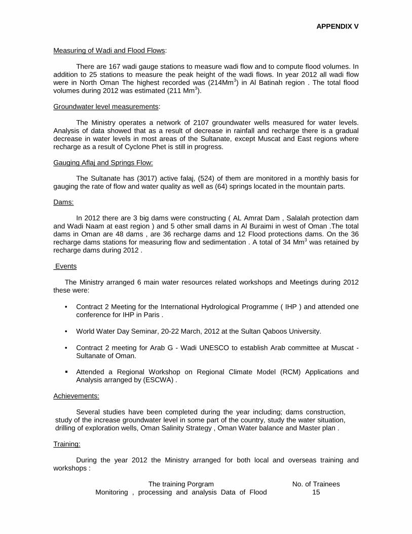
APPENDIX V
Measuring of Wadi and Flood Flows:
There are 167 wadi gauge stations to measure wadi flow and to compute flood volumes. In addition to 25 stations to measure the peak height of the wadi flows. In year 2012 all wadi flow were in North Oman The highest recorded was (214Mm3) in Al Batinah region . The total flood volumes during 2012 was estimated (211 Mm3). Groundwater level measurements:
The Ministry operates a network of 2107 groundwater wells measured for water levels. Analysis of data showed that as a result of decrease in rainfall and recharge there is a gradual decrease in water levels in most areas of the Sultanate, except Muscat and East regions where recharge as a result of Cyclone Phet is still in progress. Gauging Aflaj and Springs Flow:
The Sultanate has (3017) active falaj, (524) of them are monitored in a monthly basis for gauging the rate of flow and water quality as well as (64) springs located in the mountain parts.
Dams:
In 2012 there are 3 big dams were constructing ( AL Amrat Dam , Salalah protection dam and Wadi Naam at east region ) and 5 other small dams in Al Buraimi in west of Oman .The total dams in Oman are 48 dams , are 36 recharge dams and 12 Flood protections dams. On the 36 recharge dams stations for measuring flow and sedimentation . A total of 34 Mm3 was retained by recharge dams during 2012 .
Events
The Ministry arranged 6 main water resources related workshops and Meetings during 2012 these were:
• Contract 2 Meeting for the International Hydrological Programme ( IHP ) and attended one conference for IHP in Paris .
• World Water Day Seminar, 20-22 March, 2012 at the Sultan Qaboos University.
• Contract 2 meeting for Arab G - Wadi UNESCO to establish Arab committee at Muscat -
Sultanate of Oman.
� Attended a Regional Workshop on Regional Climate Model (RCM) Applications and Analysis arranged by (ESCWA) .
Achievements:
Several studies have been completed during the year including; dams construction,
study of the increase groundwater level in some part of the country, study the water situation, drilling of exploration wells, Oman Salinity Strategy , Oman Water balance and Master plan . Training:
During the year 2012 the Ministry arranged for both local and overseas training and workshops :
No. of Trainees The training Porgram 15 Monitoring , processing and analysis Data of Flood

APPENDIX V
instruments 14 Study and account of Floods and its impacts Direct &
indirect Method measurements 15 Wadi Hydrology 21 Analysis of Rainfall gauge Data
7. Disaster Prevention and Preparedness Component
As part of implementing its national disaster management program, Oman has carried out
various activities during 2012 aiming at enhancing its national and regional DR capabilities. These activates can be divided into the following categories;
1) Establishing the national emergency preparedness and response system; In 2011, Oman's national emergency response system was restructured with a new multi-
hazard cluster function based approach /system. In 2012, efforts were directed toward continuing the organizational and institutional aspects of the system components (sectors, regional committees, and national emergency management center). Activities included, identifying sectors organizational structure (Government agencies, NGOs, and the private sector) their representatives, and TOR. Coordination and communications activities were initiated toward developing strategic plans for each sector beside developing and exercising preparedness and response plans. In 2013, focus will be on developing integrated operational process by which different ERS components can work together in harmony toward achieving rapid and effective disaster response.
2) Enhancing governorates emergency response system : Another critical aspect of ER system development in Oman was the enhancement of regional
emergency management system with focus in the enhancement of community first response capabilities. Regional emergency management committees were restructured as per the national response system with clear identification of rules and responsibilities among stakeholders. Revised disaster preparedness and response plans are under development.
3) Adopting unified incident command system: Realizing the importance of having a common incident command system among various
responding sectors, Oman has started the development and implementation of a standard incident command system that aims at having a unified incident response structure and process among different levels of response/responders.
4) Training: Toward enhancing human recourses capabilities, training program was carried out focusing on
the following aspects:
d) Incident command system training.
e) Specialized sector /function programs ( search and rescue, medical response, relief and shelter management, critical infrastructure continuity, etc)
f) Participation in regional and international meetings, exercises and training programs. 5) Risk Reduction activities
Various risk reduction activities were executed during 2012 ncluding the following:

APPENDIX V
e) Enhancing coordination and cooperation with the national multi hazard early warning center project; especially with regard to public warning and information sharing.
f) Education for risk reduction strategy: working with NOUNSICO in developing a national strategy that aims at enhancing DRR public awareness and education.
g) Academic and scientific research: coordination with local universities and academic research centers were made toward allocating certain percentage of their annual research project toward DRR activities specially that pertaining to risk mapping, land use, etc.
h) Community vulnerability assessment and mapping
6) Emergency Information Management system: Phase II of SOEMIS project was completed with the collection of patial and statistical data of
the whole country .in January 2013, phase III started aiming at developing an intelligent decision support system that will utilize data collected in risk redaction, response, and recovery activities.
7) National search and rescue team: Oman Urban Search & Rescue Team was classified as international medium level S &R team
as per INSARAG guidelines and methodology and now ready to be deployed to international search and rescue missions.
8) Public Warning and hazard Information :
One the most effective DRR activities (that was tested during various climate situation Oman experienced during 2012) was developing standard operating procedures among Metrology, Hydrology, Emergency Management Authorities, and media. Coordination with PA for Radio and Television and other media stakeholders was made to achieve effective public warning through the provision of life data in both in TV and radio stations. Data provided included weather forecast, raining activities, flash flooded areas, hazardous area, highways and main roads blocked. Sharing of such data with effective warning campaign proved to be extremely effective way of reducing losses in lives.
Another activity, was the coordination with telecommunication industry to send bulk warning
messages to people (mobile numbers) that are nearby high risk zones (thus saving time and resources needed by directing warning activities toward affected populations only.

APPENDIX V
Country Report of the Members – Sri Lanka 1. REVIEW OF TROPICAL CYCLONES
There were no tropical cyclones crossing Sri Lanka during the year. However, Cyclone Nilam developed in the Bay of Bengal, mostly to the east of north eastern coast of the island propagated closer and influenced the weather conditions of the island and North eastern seas from 27 October to 1 November. It was first indicated in the satellite imageries on 26 October and alert messages were issued since then. It became a low pressure area by 27 October and deepened in to a depression by 28 October and further intensified in to a Tropical cyclone named Nilam by 30 October. The system moved in westward at the beginning and then, turned towards the southeast direction getting closer to the Sri Lankan coast and moved away after 30 October towards north-northwest direction. Under the influence of the cyclone, north-eastern parts were initially affected and later western and south-western parts were badly affected due to the convergence associated with feeder bands even after entering to the land on 31 October. The recorded strongest wind was 28 knots at Galle (South) on 31 October’s night and the heaviest rainfall was 187.2mm from Kantalai (Eastern Province) on 28 October. There were 3 deaths, 49 housed completely damaged and over 69,000 people were reported to be affected. However, there are no reports of casualties from maritime community during this period. 2. GENERAL WEATHER DURING THE YEAR 2012 Northeast monsoon conditions which commenced in December, 2011 continued 28 March. The monsoon was not active in terms of rainfall although some convective activity taken place in the latter part of February and in March. Overall most parts of the island received below average rainfall. Convective activity that prevailed during the inter monsoon period afterwards the Northeast monsoon until latter part of May was severe and caused strong lightning strikes and localised strong winds (down draft or tornadoes). However, the rainfall was continued to be lower than the average at most places. 32 human lives and one elephant were reported to be lost due to lightning activity by the end of May. There were a number of episodes of localised strong winds (down draft or tornados) damaging the properties during this period. The southwest monsoon got established on 06 June over the island without bringing usual heavy downpour in the setting on phase and, the monsoon was also a failure in terms of rainfall until the latter part of September (tail end). The total monsoon rainfall (May to September) was below average almost everywhere, especially over the central hills where major rivers originate and hydropower catchments are situated. The rainfall in central hills during the monsoon was around 40 % of average and most parts of the country showed large variation of rainfall ranging from 20% to 80 % of the average. Prolong deficiency in rainfall resulted in drought conditions in many parts of the country affecting badly the major paddy cultivation areas in the North Central, Uva, and Eastern provinces. The southwest monsoon winds weaken paving the inter-monsoon conditions by 14 October and fairly widespread rain associated with convection was reported afterwards. Total number of lightning rose to 45 by the end of October according to the media and other sources of information. A low pressure area developed in the Bay of Bengal by 27 October and moved towards north-eastern coast intensifying in to a tropical cyclone – Nilam and moved away. Rains with strong winds were reported over Sri Lanka and around seas from 28 October to 01 November causing floods in Western and southwester parts. The inter-monsoon conditions were active with the association of weak trough at low levels and there were number of days with very heavy rainfalls. Kalatuwawa in the western province recorded 328.8 mm of rain on 27 November. Thirteen lives and 5 pigs were reported to be
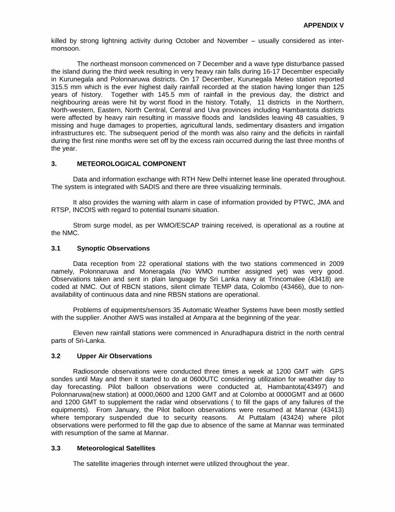
APPENDIX V
killed by strong lightning activity during October and November – usually considered as inter-monsoon. The northeast monsoon commenced on 7 December and a wave type disturbance passed the island during the third week resulting in very heavy rain falls during 16-17 December especially in Kurunegala and Polonnaruwa districts. On 17 December, Kurunegala Meteo station reported 315.5 mm which is the ever highest daily rainfall recorded at the station having longer than 125 years of history. Together with 145.5 mm of rainfall in the previous day, the district and neighbouring areas were hit by worst flood in the history. Totally, 11 districts in the Northern, North-western, Eastern, North Central, Central and Uva provinces including Hambantota districts were affected by heavy rain resulting in massive floods and landslides leaving 48 casualties, 9 missing and huge damages to properties, agricultural lands, sedimentary disasters and irrigation infrastructures etc. The subsequent period of the month was also rainy and the deficits in rainfall during the first nine months were set off by the excess rain occurred during the last three months of the year. 3. METEOROLOGICAL COMPONENT
Data and information exchange with RTH New Delhi internet lease line operated throughout. The system is integrated with SADIS and there are three visualizing terminals.
It also provides the warning with alarm in case of information provided by PTWC, JMA and RTSP, INCOIS with regard to potential tsunami situation.
Strom surge model, as per WMO/ESCAP training received, is operational as a routine at the NMC. 3.1 Synoptic Observations
Data reception from 22 operational stations with the two stations commenced in 2009 namely, Polonnaruwa and Moneragala (No WMO number assigned yet) was very good. Observations taken and sent in plain language by Sri Lanka navy at Trincomalee (43418) are coded at NMC. Out of RBCN stations, silent climate TEMP data, Colombo (43466), due to non-availability of continuous data and nine RBSN stations are operational.
Problems of equipments/sensors 35 Automatic Weather Systems have been mostly settled with the supplier. Another AWS was installed at Ampara at the beginning of the year.
Eleven new rainfall stations were commenced in Anuradhapura district in the north central parts of Sri-Lanka. 3.2 Upper Air Observations
Radiosonde observations were conducted three times a week at 1200 GMT with GPS sondes until May and then it started to do at 0600UTC considering utilization for weather day to day forecasting. Pilot balloon observations were conducted at, Hambantota(43497) and Polonnaruwa(new station) at 0000,0600 and 1200 GMT and at Colombo at 0000GMT and at 0600 and 1200 GMT to supplement the radar wind observations ( to fill the gaps of any failures of the equipments). From January, the Pilot balloon observations were resumed at Mannar (43413) where temporary suspended due to security reasons. At Puttalam (43424) where pilot observations were performed to fill the gap due to absence of the same at Mannar was terminated with resumption of the same at Mannar. 3.3 Meteorological Satellites
The satellite imageries through internet were utilized throughout the year.

APPENDIX V
Under a bilateral agreement with KOICA, a project to install a receiving system of Communication, Ocean and Meteorological Satellites (COMS) at Colombo was installed and commissioned in May. The necessary training in hardware and software were also provided by KOICA. Chinese FENYUNGCast system was fully operational and was upgraded by CMACast in September. 3.4 Ships and Aircraft Reports
Ship observations are still not received at Colombo radio shore station. However, many are received through GTS. Reception of AIREPS at Airport Meteorological office remains poor as the data are downloaded through ADS (aircraft data surveillance) with other aeronautical data at the Domestic Airport at Ratmalana and as there is no proper mechanism to sort out the AIREPS. 3.5 Improvement of facilities / Technical Advanceme nt
Civil constructions with regard to Doppler Weather Radar were continued throughout the year. The location and ground condition of the site made it much difficult task for the completion although the site is very much appropriate for radar. Construction of new buildings for Jaffna Meteorological office was commenced. A block of land has been acquired for the construction of Trincomalee (43418) Meteorological office and construction of new buildings has been commenced.
An expert committee formed taking the leading role of Department of Meteorology to “investigate to minimize the damages due to lightning” continued its activities.
Government of Sri-Lanka is planning to commence another International Airport at Mattala in Hambantota district in the south eastern part of Sri Lanka and hence new synoptic station and Meteorological Watch Office will be commenced at the airport premises to fulfill the aero meteorological requirements.
Links with RIMES was continued for Reducing Risks of Tsunami, Strom surges, Large Waves and other natural hazards in low elevation coastal zone. Under this program, to improve the forecasting capability of department activities on training and utilizing WRF model has commenced.
Issuing of seasonal rainfall forecast under experimental basis was commenced.
4. HYDROLOGICAL COMPONENT
The Department of Irrigation is the mandated institution working with hydrological issues in Sri Lanka. It is the pioneer organization responsible for developing land and water resources for Irrigated agriculture in the country while providing necessary assistance for other organizations responsible for water related infrastructure development.
Main Responsibilities and Functions of Irrigation Department: I. Preparation of master plans for river basin development; II. Planning, design, construction and management of Irrigation schemes;
III. Planning, design, construction and management of drainage and flood control
works;
IV. Conducting research works and providing specialized services in Hydrology, Hydraulics, Engineering Geology, Engineering Materials and Land Use fields to other government and private organizations.
4.1 Hydrology Division of Irrigation Department

APPENDIX V
Hydrology Division (HD) of Irrigation Department is mainly responsible for data collection,
processing and managing hydro-meteorological information system for the requirements of water resources planning, water management (in irrigation schemes), Disaster Management and flood mitigation works carried out by the department and other related organizations.
Hydrometric network managed by HD comprises of 35 permanent stations which record hourly water levels by the employees of Irrigation Department and other 40 stations which record data, twice a day, with the help of casual employees recruited from nearby villages. HD maintains 19 rainfall stations throughout the island and receives rainfall data from the Department of Meteorology and Plantation Sector also. Processed data and information are issued to the various organizations and individuals who are engaged in water related infrastructure development and research works. Summary of such information are published in the ‘Hydrological Annual’ the annual magazine of Hydrology Division.
However, the present hydrometric network maintained by HD is confined to 18 river basins (out of 103) which are most important in the hydrological point of view. This is not sufficient for present and future requirements flood forecasting and disaster management works. The major constraint in expanding the network was high labour costs involved since most of the existing stations are operated manually.
Therefore, the Government of Sri Lanka has planned to strengthen the Hydro-meteorological information System (HIMS) under the component II of ongoing ‘Dam Safety and Water Resources Planning Project (DSWRP). The main objectives of the project are:
1. Modernization and upgrading of the country’s hydro-meteorological data collection and processing system;
2. Implementation of a robust and modern database in the Hydrology Division; 3. Enhancement of capacity of key Government Agencies to undertake surface water
monitoring as well as to analyze available data and provide Flood & water supply forecasts.
Accordingly, Component II of DSWRP has a number of subcomponents as follows: I. Establishment and/or upgrading of 122 hydrometric stations; II. Establishment of a central database system for automatic data acquisition, processing,
archiving and dissemination of hydro-meteorological data and information;
III. Provision of flood forecasting and reservoir management tools and improving the analytical capacity of staff with necessary training.
Preliminary works have been already completed and instrumentation will be commenced by March 2013 and expected to be completed within 2 years. With the above improvements, the Hydrological Division of the Irrigation Department will be able to fulfil the future requirements of the country by enhancing hydro-meteorological Information system, flood warning capabilities and hazard mapping covering all major river basins of the country. 5. DISASTER PREPAREDNESS & PLANNING - WILL BE SENT LATER
The Disaster Management Centre (DMC) is the coordinating body under the Ministry of Disaster Management. It involve in disseminating the warnings and advisories from the technical agencies to the grass root level, conducting public and awareness programmes and preparedness and planning activities for prevention of the disasters with the respective agencies. District disaster preparedness plans have been completed for 16 districts and 573 plans for GramaNiladhari(

APPENDIX V
lowest level in the administration)divisional level plans were completed. 117 mock drills were also completed. Cyclone hazard mapping has been completed with technical support from Department of Meteorology and financial support from UNDP. In addition, Landslide hazard mapping, Drought Hazard Mapping, Flood Hazard Mapping also conducted. Structural measures for land slides are also conducted with National Building Research Organization. Dam Safety & Water Resources Planning project under the Ministry of Irrigation & Water Management is a major project to enhance the capacity of department of Irrigation with regard to Hydrological disaster and expected to be commencing soon. Local authorities in the disaster prone areas have been strengthen to face for the disaster by providing necessary equipment by the DMC. National safety day celebration was performed on 26th December in Badulla (landslide prone district) concentrating preparedness activities and public awareness. In the event of a Natural or Manmade disaster,Emergency Operation Centre EOC coordinates rescue operations, distribution of resources and emergency relief supplies with the assistance of Armed Forces, Police, Red Cross, UN systems and other relevant stakeholders to ensure quick evacuation and efficient distribution of relief items. EOC presently functions with a skeleton staff and plans to improve the operations with the recruitment of additional staff. UNDP, UNICEF, UNCHR, WFP, UNESCAP, UNOCHA, Red Cross and IOM have been supporting Disaster Management Centre continuously in Disaster Emergency Response and relief distribution activities while National Disaster Relief Services Centre, under the ministry provides the relief for affected community. DMC has all together 77 commissioned along the coast in addition to the telephone, cell broadcast and number of modes of communicating the warning and another 25 towers have been planned. Very successful and efficient evacuation process were introduced with utilizing the assistance of farces. 6. TRAINING COMPONENT
The Department of Meteorology organized a WMO workshop on Quality Management Systems for Aviation Meteorological Services.
Two meteorologists are currently receiving post graduate training at University of Phillipines under the fellowship of WMO and another one has returned after the completion of M.S. degree in meteorology at the University of Philippines.
The following short term training workshop/seminars organized/cosponsored by WMO were attended by the scientific staff of the department:
1. Training on Storm Surge Experts with IIT, Delhi 10-21 Dec 2012;
2. Competence Assessment of Aviation Forecasters and Observers -29/10- 02/11 2012, Israel;
3. Tropical Cyclone forecasting attachment to RSMC, 20/02-02/03 /2012, India;
4. Tropical Cyclone analysis, 17/12-19/12 – 2012, Oman;
5. Technical Planning Workshop on Severe Weather Forecasting Demonstration Project (SWFDP) Development for the Bay of Bengal Region (RA ll – South Asia), 23/01-27/01/2012, India;
6. International Training Workshop on use and Interpretation of NWP prediction model, 03-07/12/2012, India;
7. Ocean Observation and instrument calibration, 19-21/November, 2012, India;

APPENDIX V
8. SASCOF-3 meeting and Workshop on seasonal prediction of southwest monsoon
rainfall, 16-20 April 2012, India;
9. SW Indian Ocean Climate Outlook Forum – SWIOCOF, 24/09 to 03/10/2012 , LA reunion.
In addition, scientific and engineering staff members also participated for short period in
training programmes arranged by JICA, KOICA, JMA, RIMES, ADPC and SMRC.
Two training workshops were conducted by the Department for Agro meteorology data collecting personals.
Two training workshop were also conducted for meteorological technicians under Continual Education and Training program. Two years duration training program for newly recruited trainee grade of Meteorological Technicians were completed in the year 2012. 7. RESEARCH & DEVELOPMENT
The following research studies were conducted by the Department during the year 2012:
1. Validation and verification studies on WRF;
2. Analysis of Rainfall Trend for the period of 1990-2010;
3. Analysis of trends in Temperature;
4. Development of display and decoding the synoptic observations;
5. Development of display system for AWS 10 minutes Data;
6. Effect of moon face on onset of Southwest Monsoon;
7. Studies on 3 day forecast by utilizing WRF model;
8. Tuning the WRF model by changing the Physics;
9. Decadal Rainfall Analysis (1951-2010);
10. Decadal Mean Temperature Analysis(1900-2010);
11. Calculation of Extra-terrestrial radiation pattern over Sri Lanka;
12. Identification of monsoon failures & extremes using SPI index (1951-2010);
13. Prediction of seasonal rainfall.
_____

APPENDIX V
Country Report of the Members – Thailand 1. REVIEW OF TROPICAL CYCLONES
No tropical cyclone around the Indian Ocean entered and affected Thailand in the past year.
In 2012, there were 29 tropical cyclones formed in the region of North West Pacific, South China Sea and Bay of Bengal, which covered in the synoptic weather map of Thailand region (Latitude 15°S to 45°N and longitude 65°E to 150°E) . However, only 13 had origin or came across the area that might have an impact on the weather of Thailand (latitude 0°-25°N and Longitude 90°-120°E). Table 1 presents the detail of all trop ical cyclones, include its period, formation and decay.
Table 1: All Tropical Cyclones came across Western Pacific No. Period Sources Dissipated area
1. TD1 17 – 21 Feb Lower South China Sea Lower South China Sea
2. PAKHAR 1201 29 Mar – 2 Apr Lower South China Sea Cambodia
3. TALIM 1205 17 – 21 Jun Northwest Pacific The North coast area of Taiwan
4. DOKSURI 1206 25 – 20 Jun Northwest Pacific Southern China
5. VICINTI 1208 19 – 26 Jul Northwest Pacific Border of China Myanmar and Laos
6. SAOLA 1209 27 Jul – 3 Aug Northwest Pacific Fujian, China
7. KAI-TAK 1213 12 – 19 Aug Northwest Pacific South China near Myanmar border
8. TEMPIN 1214 18 – 31 Aug Northwest Pacific Northern China
9. GAEMI 1220 30 Sep – 8 Oct Central South China Sea Thailand
10. SON-TINH 1223 22 – 30 Oct Northwest Pacific Southern China
11. TD2 13 – 16 Nov Central South China Sea Near Southern Vietnam coast
12. BOPHA 1224 25 Nov – 9 Dec Northwest Pacific Philippines
13. WUKONG 1225 24 – 28 Dec Northwest Pacific Southern China
Figure 1: Tracks of Tropical Cyclones from Pacific Ocean in 2012 Source: Climatological Center, Thai Meteorological Department

APPENDIX V
During the period 1 January to 31 October 2012, only one tropical cyclone hit Thailand, namely tropical storm “Gaemi (1220)”, which developed from the low pressure cell over the middle of the South China Sea (13.5 °N, 113.0 °E) at 0000 UTC on 30 September. This depression had moved northwards on the first day and then northeastward. It intensified into a tropical storm at 0600 UTC on 1 October and turned southeastward and eastward, respectively. It continued to develop to a severe tropical storm and reached its peak intensity with the maximum wind of 50 knots near its centre. A gradual turn to the west occurred on 4 October and continued its westerly track towards Vietnam before making landfall in Qui Nhon, Vietnam on 6 October. It then entered Cambodia and downgraded into the tropical depression and moves further into Sa Kaew province, Thailand on late 7 October. Gaemi became low pressure cell over the eastern and central regions of Thailand on the following day and intensified the monsoon trough, lying across central and eastern regions of Thailand. This resulted in plentiful rain mainly over the central and eastern Thailand. The highest daily rainfall was 92.1 mm in Tak Fah District, Nakhon Sawan Province on 8 October. For the track of Gaemi and accumulated amount of rainfalls are as in figure 3 below. Table 2 shows only the tropical cyclone which made its way through the regions of Thailand.
Table 2: Tropical Cyclone came across came across Thailand
Tropical Cyclone came across Thailand
Dissipated area No.
Intensity Province Date
Tropical Cyclone came
across Region Date 1. GAEMI Depression Sa Kaew 7 Oct - Thailand 8 Oct
Figure 2: Track of Tropical Storm GAEMI (1220), 2012 Source: Climatological Center, Thai Meteorological Department

APPENDIX V
Figure 3: Accumulated amount of rainfalls from 6 October until 8 October 2012 Source: Climatological Center, Thai Meteorological Department
2. METEOROLOGICAL COMPONENT
In 2012, internal offices of the Thai Meteorological Department (TMD) carried out activities
in enhancing and raising projects to reach success; someway, some problems occurred. 2.1 Weather Forecasting Service
Thailand issues the routine day-to-day weather forecast and the tropical cyclone warning. For public awareness and advice, much more weather advisories are issued at frequent interval if cyclones form in areas of the Indian Ocean and the North Pacific Ocean. The bureau will then transmit weather products to public and related agencies by telephone, fax, e-mail, website, and mass media.
Based on analyzing and forecasting tools, still the TMD uses primitive method, Dvorak
technique and NWP products (EPS) in the growth of tropical cyclones. The accuracy of severe weather forecast and warning, and movement are related to technique and instrument.

APPENDIX V
Depended on the internet, data were exchanged through GTS Circuit with various meteorological centers, such as the JMA and the JTWC. These exchanged data were proved very effective and useful to adjust more accuracy of the storm’s course and intensity.
2.2 Ocean wave and Storm Surge Forecasting
Marine Meteorological Center under Thai Meteorological Department has been responsible for running Ocean wave and Storm surge model. In part of Storm Surge model, TMD has been using JMA Storm Surge Model, COHERENS and SMS model as operational in order to do warning people in the Gulf of Thailand and the Andaman Sea. The model products have shown the sea level changes or the maximum storm surge height map due to the influence of wind and low air pressure along the Gulf’s coast. You can visit our webpages as below:
http://www.marine.tmd.go.th/wam.html , http://www.oceansky.tmd.go.th/ 2.3 Satellite Reception
The satellite ground receiving station had been enhanced with application program for
meteorological data in different platforms through satellites, for example, MTSAT, FY-2, TIROS (NOAA), and Terra/Aqua Direct Broadcast (MODIS). About severe weather monitoring, these products would support more accurate analysis. Now it is in the process of verification.
2.4 Surface weather stations
A total of 124 surface weather stations (74 synoptic stations, 16 hydro-Met stations and 34 Agro-Met Stations) are employed throughout Thailand, mostly surface weather. Some stations are assigned for WMO-RBSN, RBCN, GSN and GUAN stations. Almost all surface stations are operated 8 synoptic times daily (00UTC, O3UTC, 06UTC, 09UTC, 12UTC, 15UTC, 18UTC, 21UTC). Mixed standard manual and modern automatic weather instruments are used. Coded messages are sent from the observing stations manually. Data quality assurance/control is performed both real-time (on message programing) and non-real-time. Data are recorded manually at the station in a log-book and on PC to be sent as WMO-coded messages to the head quarter in Bangkok to further distributed via GTS and kept as archive at the climatological data section. Real-time automatic weather reports are available to the forecasters and public (via web) and separately archived. If we divided by region, northern part has 31 stations, north eastern part has 28 stations, central part has 21 stations, south western part has 8 stations and south eastern part has 21 stations. 2.5 Upper-Air Observatory
Routine upper-air observation at 11 stations across Thailand is released four times a day
at 00, 06, 12, 18 UTC for Met-data, for examples, pressure, temperature, humidity, and wind speed and direction at vertical levels up to altitude about 16-25 km. Each station has different types of observatory as shown in Table 3 below: Table 3

APPENDIX V
2.6 Telecommunication
- Replacement of old analog with digital system improves the linkage of the GTS and the AFTN;
- Control systems of telecommunication networks increased the development of a
national early warning system and enhanced the data-collection system of meteorological stations across the country;
- The GTS connected the TMD with the National Disaster Warning Centre (NDWC) for
scattering DART BUOY, installed in the Indian Ocean, to the WMO’s member countries. It also helped in-and-out data exchange improve in Table-Driven Code Form (TDCF). This project supported the TMD to be the RTH Bangkok WIS portal in Southeast Asia.
2.7 Awareness Activities
Public awareness was designed to educate students, teachers and public all about weather as seen successful projects, namely, “Meteorological Roaming” and “Training Teachers of Meteorology”. Otherwise, we stressed on news distribution through public via media. 2.8 Information Access
The official website of the Thai Meteorological Department http://www.tmd.go.th serves
people very well. They can surf and access to weather forecasts, warnings, tracks, meteorological reports, aviation weather charts and earthquake reports. You can access marine meteorological information such as ocean wave forecast product, storm surge model products and so on at http://www.marine.tmd.go.th . 3. HYDROLOGICAL COMPONENT
3.1 Enhancement of Facility
Water management in Thailand comes under the care of two government agencies: Royal Irrigation Department (RID) and Department of Water Resource (DWR). The RID has strategies for flood prevention and mitigation, as well as impacts in urban and cultivated areas, with aims to reduce the loss of lives and properties of population at risk. Management plans are set in terms of monitoring, predicting and warning by establishment of

APPENDIX V
Water Watch and Monitoring System for Warning Center (WMSC) to examine flood situations 24 hours. In addition, the collaborations with national related agencies for implementation plan cope with local flood protections in economic zones where severe flood may occur. The state-of-art technologies were established, such as telemetry and flood forecasting systems. Similar to 571 manual river gauges and 2,294 manual rain gauges, 24 of 25 main river basins have 711 telemetric stations installed for water resources management and flood prevention and mitigation, RID have 2 projects to improvement of Flood Observation and Forecasting System by
1. Integrate the tele-metering system of 10 river basins - Ping Basin
- Wang Basin - Yom Basin - Nan Basin - Chao Phraya Basin - Thachin Basin - Sakaekrang Basin - Pasak basin - Prachinburi-Bangpakong Basin - Maeklong Basin
The project will be completed on September 24, 2012 (Figure 4:)

APPENDIX V
Figure 4: Integrate the tele-metering system of 10 river basins
2. RID data Center (Figure 5:)
Hydrological Data (rainfall, water level and flow) are sending every 15-minute with Automatic Real-time from the 23 river basins of telemetry systems (Thailand has 25 river basins)
Involved in natural rivers and steep-slope upstream watershed, the DWR has developed and installed the early warning systems with automatic flood-warning sirens in 458 of 2,370 villages in disaster areas throughout Thailand. Last 2011, 7 of 37 existing telemetric systems were additionally installed with flood models of both hydrometeorology and hydrodynamic, such as MIKE11, MIKEGIS, INFOWORK and AIT River network. The risk of floods are mitigated and reduced in three steps following.
• First, the total 711 telemetric systems installed in 24 of 25 river basins throughout Thailand monitor real-time hydrological data for flood forecasting;
• Second, the forecast was issued and transmitted to regional offices, local agencies and
public through website, radio broadcasting or media;
• Last, after flood events, water drainage pumping begins to reduce high water level or inundation. The headquarters and regional offices then provide equipment for flood recovery, such as 1200 mobile pumps, 121 impeller pumps, 37 backhoes, 17 dredgers, 29 tractors 44 trucks, 295 water trucks and 6 boats.
APPENDIX V
Figure 5: RID data Center 3.2 Achievement RID’s staff attending training, workshop and conference both local and oversea have acquired more knowledge on technology relating flood forecasting and water resource management. 4. DISASTER PREVENTION AND PREPAREDNESS COMPONENT 4.1 Key Members on Work Key agencies involved in disaster preparedness and protection includes the National Disaster Prevention and Mitigation Committee (NDPMC) and the Department of Disaster Prevention and Mitigation (DDPM). Under the Ministry of Finance, the NDPMC determines the regulations of payment in mitigation and prevention activities of all related agencies regarding the national disaster prevention and mitigation plan. The Department of Disaster Prevention and Mitigation (DDPM), under the Ministry of Interior, is a primary government agency in disaster management, responsible for imposing and implementing program policy, formulating operational guidelines and establishing criteria on disaster management. The DDPM requires promoting disaster prevention and preparedness, assisting disaster management with specialists, hardware, and software, and also assists in loss reduction of life and negative impact of all disasters. In addition, it organizes and conducts training activities related to all disaster management by collaboration with local and international organizations, such as ADRC, ADPC, JICA, GTZ, UNDP UNISDR, UNOCHA, UNEP, and so on. The DDPM cooperated with United Nation International Strategy for Disaster Reduction (UNISDR) and Asian Disaster Preparedness Centre (ADPC) to formulate Strategic National Action Plan (SNAP) for Disaster Risk Reduction for Thailand and set up the working group composed of representatives from agencies concerned to draft SNAP. The draft plan is now submitting to the Cabinet for approval. 4.2 Framework of Early Warning System An early warning system in Thailand is divided into 2 levels: national and local level. In the national level, the disaster warnings and forecasts from related agencies will be spread to people through mass media. The DDPM will put them into the mechanism of the Ministry of Interior scattered to provinces, districts and local agencies. In the local level, the low cost rain gauge simple to use and manual disaster siren have been installed in the flooded areas to observe and notify disaster forecasts and warnings. The villagers, as trainees, will learn how to measure, record and read daily rainfall amount. If the rainfall exceeds the predefined normal level, the village headmen will be notified to spread warnings through the broadcasting centers by the manual siren device. 4.3 Enhancement of Disaster Management Several projects have launched for enhancing the efficiency in disaster management. Community Based Disaster Risk Management (CBDRM)
For improving public safety in risk areas, the CBDRM increases public capacity in disaster
management. The DDMP cooperated with local agencies and international agencies to generate

APPENDIX V
public awareness, as seen at present, more than 60,000 people in risk communities have been trained on this approach. In this year, the DDPM focuses on 18 communities selected from overall country to be retrained for sustainable community on disaster prevention. Mr Disaster Warning
Flashflood and Mudslide Warning Program aims for enhancement of local capacity in risk
assessment and early warning collaborated with the Department of Provincial Administration, the Department of Local Administration, Meteorological Department, National Park Wildlife and the Plant Conservation Department, and National Disaster Warning Centre. Mr Warning is the voluntary villager functioning as a vigilant, a fore warner and a coordinator, now, having 20,296 persons in flood prone areas. Disaster Prevention and Mitigation Academy (DPMA)
As a national training center, the DPMA has begun since 2004 to develop curricula and
mobilize technologies for standard training with collaboration of national and international agencies. This is to increase in capacity of the persons in charge of disaster management. The curricula of 6 campuses consists the Fire Fighting, Building Collapse (Search and Rescue), Hazmat Emergency Management, Civil Defense Volunteer and Disaster Management. One Tambon One Search and Rescue Team
The Project of “One Tambon (sub-district) One Search and Rescue Team (OTOS)”
stresses on the establishment, training and long-term maintenance in sub-district communities. It cooperates with various agencies, such as, the Department of Local Administration, Health Insurance Office, the Office of Health Promotion and Support Fund, and Thai Red Cross.
The objectives are (1) to ensure safety, and the rapid, efficient search and rescue; (2) to
increase effective search and rescue team at every place throughout the country; (3) to build up capacity and effective search and rescue team by technical training and drilling; and (4) to provide first aid treatment and rapid transfer to medical. Last year, 73,371 persons throughout the country were 85% complete involved in OTOS program. Capacity-Building of Civil Defense Volunteer
Recruited from local residents aged over 18 years, the civil defense volunteers have been trained the 5-day course on Civil Defense Volunteer to assist disaster management with now 1,200,176 volunteers in the country.
This program aims to increase public capacity on disaster prevention including search and
rescue activities. After the training, the volunteers will organize officially locating at their communities and assist the government in case of emergency. 5. RESEARCH COMPONENT
The following research studies were conducted by Marine Meteorological Center under Thai Meteorological Department during the year 2012:
� Wind-wave Characteristics Generated by Tropical Cyclone Activity in the Gulf of Thailand
� Virtual Wave : an Algorithm for Visualization of Ocean Wave Forecast in the Gulf of Thailand
� Understanding the Simple Model of Tsunami Propagation by SiTProS Model � Decision Support System for Flash Flood Warning Management using Artificial Neural
Network

APPENDIX V
� A Neural Network Model for Surface Air Temperature Estimation over the Eastern Part of Thailand in 2004
� Implementation of Neural Network for Spatial-Temporal Interpolation of Sea Surface Temperature in the Gulf of Thailand
� Wind-Wave and Tsunami Model in Thailand � Analysis of Coastal Erosion by Using Wave Spectrum � Forecasting Tropical Cyclone Movement by Neural Network � Decision Support System for Prediction Air Temperature in Northern Part of Thailand
by using Neural Network � The Simulation of Wave model Under North-East Monsoon Along Coastline of
Thailand � Coupling of high-resolution meteorological and wave models over the Gulf of Thailand � Affected by the northeast monsoon and the influence of the cyclone in the Indian
Ocean induced Huge Wave along the eastern coastline of southern part of Thailand during December 25 - 28, 2011
� Alternative sites for HF Radar location along the shores of the Gulf of Thailand and the Andaman Sea
6. TRAINING COMPONENT
In 2012, Thai Meteorological Department has sent officers to training workshops on various topics to apply their knowledge in order to develop routine job. Details of the training are listed below.
- 2 TMD officers joined the Training on Radar Composite Map Technique, held in Tokyo, Japan, 18-23 November 2012;
- 1 TMD officer joined Climate Prediction Training Program 2012, held in Busan, Republic of Korea, 18-30 November 2012;
- 1 TMD officers joined International Training Workshop on “The Latest Development on the Use an Interpretation of Numerical Weather Prediction (NWP) Models”, held in Hong Kong, China, 2-8 December 2012;
- 1 TMD officer joined ASEAN Training Course on Earthquake Monitoring, Tectonic Deformation, Seismic Zoning Methods and Tsunami Early Warning System, held in Jakarta & West Java, Indonesia, 17 November-1 December 2012;
- 1 TMD officer joined International Training Course for Weather Forecasters, held in Nanjing, China, 16-27 September 2012;
- 1 TMD officer joined the Ewha International School on Data Assimilation (EISDA 2012), held in Seoul, Republic of Korea, 21-24 August 2012;
- 2 TMD officers joined Climate Prediction and Application Training Program for Green Growth in Developing Countries 2012, held in Busan, Republic of Korea, 3-15 June 2012;
- 1 TMD officer joined Training on Natural Disaster Management, held in Nakhonpathom, Thailand, 28 May-15 June 2012;
- 2 TMD officers joined Training Program on Consultancy Needs and Services in Disaster Management in Thailand, held in Bangkok, Thailand, 19-20 March 2012;
- 1 TMD officer joins Training on Operational Tropical Cyclone Forecasting, held in New Delhi, India, 19 February-March 2012;
- 1 TMD officer joins International Training Course on McIDAS-V Software Application in Satellite Meteorology, held in Beijing, China, 11-21 June 2012;
- 2 TMD officers joined Capacity Building in Regional Numerical Weather Prediction Based on the COSMO Model, held in Langen, Germany, 16-27 July 2012;

APPENDIX V
- 1 TMD officer joined APEC Training Course on Quantitative Precipitation Estimation/Forecasting (QPE/QPF), held in Quezon City, Philippines, 27-30 March 2012;
- 1 TMD officer joined the 8th Post Graduate Course in Satellite Meteorology and Global Climate, held in Ahmedabad, India, August 2012 - 30 April 2013;
- 1 TMD officer joined Typhoon Committee Research Fellowship Scheme 2012, held in Seoul, Republic of Korea, 1 May-29 June 2012;
- 1 TMD officer joined Capacity Building on Acid Deposition and Impact Assessment Analysis, held in Tokyo, Japan, 5-16 March 2012;
- 1 TMD officer joined International Training Seminar on “Methods for Short-term Climate Prediction”, held in Nanjing & Beijing, China, 26 March-7 April 2012;
- 1 TMD officer joined International Training Course on Weather Radar Operation and Data Utilization, held in Seoul, Republic of Korea, 4-17 March 2012.
______

APPENDIX VI
AOPs
Coordinated Technical Plan (CTP) for the WMO/ESCAP Panel on Tropical Cyclones - Annual Operating Plan for 2013 -
Expected Result Strategic Goal Activity
ER-1 (Meteorology) Enhanced capabilities of Members to produce better forecasts and warnings of tropical cyclones and storm surges.
1-a To improve and expand the observing system of surface, upper-air, ship, buoy, aircraft, radar and satellite observations in the Member countries.
To strengthen of the cooperative relationship with the Airlines for development of the regional AMDAR programme (Members, WMO).
1-b To implement and operate adequate Members’ connection to the WMO Information System (WIS) for operation-critical data exchange through dedicated telecommunication means of the GTS, and through broadband Internet access for Data Discovery, Access and Retrieval service.
Members to implement plans to deploy WIS functionality.
1-c To increase accuracy, timeliness and usefulness of tropical cyclone forecasts and warnings.
1) To conduct case studies on the events where gaps were found in TC intensity analysis between RSMC and the Members (Oman, RSMC). 2) To establish and enhance the communication between the operational forecasters in RSMC and the Members (RSMC, PTC-S). 3) To develop collaborative links with the Severe Weather Forecasting Demonstration Project and the Coastal Inundation Forecasting Demonstration Project of WMO (Members, PTC-S, WMO) 4) To promote the use of Common Alerting Protocol (CAP) in partnership with WGDPP (WMO, Members). 5) To implement TC Landfall Forecast FDP (RSMC, Members) 6) To prepare an assessement report on the current status and needs of the Members with respect to data, products, analytical and forecasting procedures.
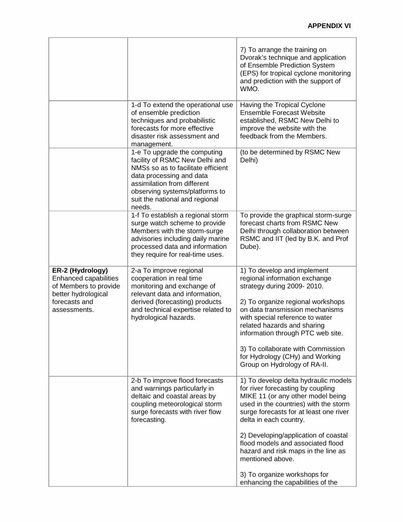
APPENDIX VI
7) To arrange the training on Dvorak’s technique and application of Ensemble Prediction System (EPS) for tropical cyclone monitoring and prediction with the support of WMO.
1-d To extend the operational use of ensemble prediction techniques and probabilistic forecasts for more effective disaster risk assessment and management.
Having the Tropical Cyclone Ensemble Forecast Website established, RSMC New Delhi to improve the website with the feedback from the Members.
1-e To upgrade the computing facility of RSMC New Delhi and NMSs so as to facilitate efficient data processing and data assimilation from different observing systems/platforms to suit the national and regional needs.
(to be determined by RSMC New Delhi)
1-f To establish a regional storm surge watch scheme to provide Members with the storm-surge advisories including daily marine processed data and information they require for real-time uses.
To provide the graphical storm-surge forecast charts from RSMC New Delhi through collaboration between RSMC and IIT (led by B.K. and Prof Dube).
ER-2 (Hydrology) Enhanced capabilities of Members to provide better hydrological forecasts and assessments.
2-a To improve regional cooperation in real time monitoring and exchange of relevant data and information, derived (forecasting) products and technical expertise related to hydrological hazards.
1) To develop and implement regional information exchange strategy during 2009- 2010. 2) To organize regional workshops on data transmission mechanisms with special reference to water related hazards and sharing information through PTC web site. 3) To collaborate with Commission for Hydrology (CHy) and Working Group on Hydrology of RA-II.
2-b To improve flood forecasts and warnings particularly in deltaic and coastal areas by coupling meteorological storm surge forecasts with river flow forecasting.
1) To develop delta hydraulic models for river forecasting by coupling MIKE 11 (or any other model being used in the countries) with the storm surge forecasts for at least one river delta in each country. 2) Developing/application of coastal flood models and associated flood hazard and risk maps in the line as mentioned above. 3) To organize workshops for enhancing the capabilities of the

APPENDIX VI
countries.
2-c To enhance regional capabilities relating to flood hazard mapping in delta and coastal regions through continued interaction with the user agencies.
1) To undertake flood hazard mapping at least in one major delta/coastal area in each country during the next five years. 2) To organize workshops for capacity building. 3) To collaborate and share experiences with Typhoon Committee.
2-d To improve management of water resources, including assessment of surface and ground water resources in relation to tropical cyclones.
-
ER-3 (DPP) Enhanced capabilities of Members to promote tropical cyclone disaster resilient communities through providing guidance on multi-hazard early warning dissemination and response mechanism.
3-a To improve regional cooperation in policies and strategies on DPP, especially those related to tropical cyclones.
-
3-b To promote regional information system to support development of policies and strategies on DPP at the regional level as well as at the national level.
-
3-c To improve public awareness of the impacts of tropical cyclones and possible mitigation and response actions through effective communication with the media prior to, during, and after tropical cyclone occurrences.
-

APPENDIX VI
3-d To Improve coordination and interaction between meteorological/hydrological services on the one hand and emergency management/disaster response agencies on the other hand through integrated emergency management, disaster response and preparedness programmes.
-
3-e To strengthen regional cooperation on DPP information exchange through networking.
-
3-f To improve multi hazard disaster risk management, especially those related to cyclone-related disaster preparedness.
-
ER-4 (Training) Development of a strategic approach to capacity building with a regional perspective.
4-a To arrange training programmes on the use of NWP model products and their application in Cyclone (track and intensity) and storm surge prediction.
To produce a prioritized list of training needs and opportunities of PTC Members through a survey from PTC Secretariat (PTC-S, WMO, ESCAP) and advise WMO for reporting, planning and implementation purposes.
4-b To arrange training programmes on media coordination during disasters and their effectiveness on “human response”.
-
4-c To arrange training programmes on theuse of Doppler Weather Radar products in Cyclone forecasting.
-
4-d To exchange visits of faculty members among Member countries to share their experiences and expertise on cyclone & related disaster management aspects.
-
4-e To enhance WMO’s fellowship support on tropical cyclone related programmes.
-
ER-5 (Research) Enhanced capabilities of Members to cope with high impact weather through research.
5-a To produce regional assessment of the impact of climate change on tropical cyclones.
To collect data/materials/papers from the Member countries which are relevant to the regional assessment.

APPENDIX VI
5-b To develop storm surge and river flood coupling model over specific river basins for forecasting of coastal inundation.
-
5-c To update vulnerability maps for various parameters like wind force/peak storm surge etc., based on latest available database.
-
ER-6 (Partnership) Enhanced use of forecasts and warnings for tropical cyclones and storm surges for decision making and implementation by Members and partner organizations.
6-a To promote exchange of information and data among Members to enhance regional cooperation in meteorology, hydrology, DPP, training and research.
-
6-b To enhance cooperation with other regional bodies, organizations, service providers and sectors for more effective provision of the forecasts and warnings.
-
6-c To develop proposals of joint projects in the areas of five components including resource mobilization.
-
ER-7 (Management and Governance) Effective management and functioning of the Panel.
7.a To improve the coordination and decision making process of the Panel.
-
7.b To enhance effectiveness in implementation of CTP and AOPs.
-
7.c To ensure effective and collaborative relationships among working groups of Meteorology, Hydrology and DPP.
-
7-d To improve coordinated technical planning process as well as monitoring and evaluation.
-

APPENDIX VII
Final Report of Workshop on Tropical Cyclone Analys is and Forecasting
Muscat, Oman, (17 - 19 December 2012)
1. INTRODUCTION At the kind invitation of the Government of Oman, Workshop on the Tropical Cyclone Analysis and Forecasting was held in Muscat, Oman from 17 to 19 December 2012. The workshop was organized by the Working Group on Meteorology (WGM) of the WMO/ESCAP Panel on Tropical Cyclones (PTC) according to the recommendation of the 39th session of PTC (5-9 March, 2012; Nei Pyi Taw, Myanmar). 2. BACKGROUND AND OBJECTIVE At the 39th session, a problem was presented by the Members about inconsistencies between the advisories of RSMC New Delhi and the forecasts of NMHSs of the Members which were found in some cases of the tropical cyclones affecting the region during the 2011 cyclone season. In view of more adequate and consistent forecasting/warning services in the region, PTC decided to hold a face-to-face meeting of WGM with participation of RSMC and the Members concerned for achieving the better coordination among the Panel Members in the operational tropical cyclone analysis and forecasting procedures. 3. ORGANIZATION OF THE WORKSHOP The workshop was attended by the forecasters of Bangladesh, India, Myanmar, Oman, Pakistan and Sri Lanka. The list of the participants is given in section 3.1. It was also attended by the staff members of the Meteorology and Air Navigation of Oman as observers. Workshop was focused mainly on 1) RSMC advisories distributed to the Members, 2) operational forecasting procedures in RSMC and the Members, 3) case studies on the cyclones with significant discrepancies between RSMC and the Members forecasts, and 4) general discussion for improvement of the situation and recommendations. The programme and agenda of the workshop can be found in section 3.2. Members’ reports summarizing their forecasting procedures are given in section 3.3. Members of different participating countries appreciated the cooperation extended by RSMC, New Delhi, especially in terms of issue of bulletins like tropical weather outlook & tropical cyclone advisory bulletins, cyclone best track data and graphics in electronic form available in IMD website and the reports on individually cyclonic disturbances prepared by RSMC, New Delhi and shared with the member countries. The analytical consideration of the current problems with respect to consistency in RSMC advisory bulletin and bulletin issued by member countries are given in section 3.4 and recommendations of the workshop are in section 3.5. PowerPoint presentations made by RSMC and the Members during the workshop are also available from the WMO/TCP website together with this final report at http://www.wmo.int/pages/prog/www/tcp/Activities.html.

APPENDIX VII
3.1 LIST OF PARTICIPANTS
MEMBERS PARTICIPANTS
BANGLADESH
Mr Shamsuddin AHMED Bangladesh Meteorological Department [email protected] [email protected]
INDIA
Dr. M. MOHAPATRA India Meteorological Department [email protected]
MYANMAR
Mr Kyaw Lwin OO
Department of Meteorology and Hydrology [email protected]
OMAN
Mr Khalid Khamis Saif ALJAHHWARI Department of Meteorology [email protected]
PAKISTAN
Mr Muhammad HANIF Pakistan Meteorological Department [email protected]
WMO SECRETARIAT
Mr Koji KUROIWA Tropical Cyclone Programme [email protected]

APPENDIX VII
3.2 WORKSHOP PROGRAMME

APPENDIX VII

APPENDIX VII
3.3 INCONSISTENCIES BETWEEN RSMC ADVISORIES AND NMHSS FORECASTS Current status :
Various agencies involved in monitoring and prediction of tropical cyclones (TCs) over different Ocean basins perform analysis of TCs to determine the best estimate of a TC’s position and intensity during its lifetime. This process is described as “best tracking”. However, the best tracking process is temporally inhomogeneous by construction because available data and techniques and general knowledge have changed over time. Furthermore, it is also inhomogeneous spatially, as procedures and data availability differ at each agency. Thus, the resulting best track and intensities from any Regional Specialised Meteorological Centre (RSMC) sometimes vary from those estimated by National Meteorological and Hydrological Services (NMHSs). These differences in estimates create problems for disaster managers and public to combat with the disasters due to cyclones.
Currently, the location of the centre of the system is determined based on (a) Synoptic,
(b) Satellite and (c) radar observations. The satellite is the main source of locating centre of cyclonic disturbances (CDs) over the mid-oceanic region. However, the observational data from ships and buoys support the decision sometimes. It is the case when the CD is far away from the coast and not within the radar range. When the system comes closer to the coast, radar position gets maximum preference followed by the satellite. When the system is very close to coast or over the land surface, the coastal observations get the highest preference followed by radar and satellite observations.
Intensity of a CD is generally reported as the maximum sustained surface wind (MSW)
over a specified time period. Operationally, the value of MSW is almost never measured. The procedure followed in estimating the intensity necessarily deals with estimation of associated MSW, estimated central pressure and pressure drop at the centre with the available observations in the region. Currently, the intensity estimation takes into consideration (a) satellite (Geostationary, Polar and scatterometer etc), (b) Radar (conventional S-band cyclone detection radar and S-band Doppler weather radar) and (c) synoptic analyses. Like the location of the system, when the system is far away from the coast and not within the radar range, satellite estimated intensity based on Dvorak’s technique (Dvorak, 1984) gets maximum weight. When the system comes closer to the coast, radar estimated intensity is considered along with satellite estimated intensity. When the system is very close to coast or over the land surface, the coastal observations get the highest preference followed by radar and satellite observations for estimating the intensity.

APPENDIX VII
3.4 REASONS FOR DIFFERENCE IN ESTIMATES OF RSMC AND NMHSS
(i) Observational data
Operational procedures to produce TC best track depend on the way the data are estimated and reported. The data available to forecasting centres at the time of decision making may be different for different centres. (a) While most of the GTS data are common for all NMHSs and concerned RSMC, there
may be the situation of availability/ non-availability of those data through failure of GTS link or slow speed of the link.
(b) Synoptic data may not be available to all centers on real time basis (c) Data through special campaigns e.g. Ocean Cruise etc. during cyclone period by any
agency may not be available to others (d) The availability of latest observational tools like Doppler weather radar and high wind
speed recorder, meteorological buoys etc may not be uniform at all centres.
(ii) Tools and techniques
The tools and techniques available for analysis of various layers of data including surface, upper air, satellite and radar etc are not uniform for all the NMHSs and the concerned RSMC. (a) The data plotting and analysis procedure is still subjective and manual in certain centers
whereas, it is very objective in some centers. (b) The location and intensity estimates by Dvorak’s technique vary from centre to centre,
as availability of the satellite imagery and products may vary from centre to centre. (c) While some centres use microwave imageries to fine tune the Dvorak’s estimates, some
are still using manual estimation from visible/IR imageries. Some are also using objective Dvorak’s technique (ODT).
(iii) Analysis procedure (a) The criteria for classification also vary from centre to centre yielding different
nomenclature for the same intensity of the system (b) While some countries maintain round the clock watch and analyze every three hourly,
some maintain dawn to dusk watch. Some countries though maintain round the clock watch, issue the bulletins twice a day or four times a day. As a result there may be variation in timing of up gradation/degradation of intensity of the system by different centers.
(iv) Decision making
The decision regarding the location and intensity of the system mainly depends on above factors. However, the human factor also plays a dominant role. (a) The experience and expertise of the cyclone forecaster in decision making differ within
and among the NMHSs and RSMC. (b) Local knowledge and experience also helps in proper diagnosis of the system.

APPENDIX VII
Recognizing the facts and circumstances it appears that (i) Panel member countries National Tropical Cyclone Warning center (NTWC’s) should
be set up or prepared in such a way that National Tropical Cyclone Warning Center (NTWC’s) can provide reliable and timely early warning independently to its own national authority to save lives and reduce loss of properties incase of communication cut off/failure among RSMC and National Tropical cyclone warning center (NTWC’s) during tropical cyclone or any disaster situation.
(ii) During the last 40 years NWP and Satellite communication has developed
tremendously and more high computing technology compared to the past are available now. Projects should be undertaken to develop location specific ( Bay of Bengal & Arabian Sea) Tropical Cyclone Model that can address climate change in the region for the benefit of the panel member countries.
(iii) More lead time for early warning can be obtained from high resolution NWP. Upper
Air Observation or vertical profile of the atmosphere is one of the most important input for three dimensional analysis of weather systems and NWP model. Members should take initiative to strengthen upper air observations.
(iv) For the introduction and inclusion of the last 40 years progress and achievements in
the field of science of meteorology into the NTWC’s of panel countries, an in-depth gap analysis or need assessments of the NTWC’s with respect to Physical infrastructure , data, products, analytical and forecasting procedures is required.
3.5 RECOMMENDATIONS 1) The workshop reiterated that analysis and forecasting of tropical cyclone should be
performed based on the scientifically agreeable data and procedures. 2) There should be a mechanism to ensure sharing of all available data and products on real
time basis among the RSMC and all members of panel countries, such as Website (RSMC and member countries websites – V-Lab etc…) in addition to GTS. It will ensure the uniformly available information to all forecasting centers to arrive at decision making.
3) There should be a discussion forum through internet or telephonic conversations, where
the opinions of forecasters can be exchanged. In the absence of such discussion forum, a group mail can be created. Oman has volunteered to create a discussion forum within V-Lab project.
4) A status and need assessment reports of various NMHSs with respect to data, products,
analytical and forecasting procedures to be prepared by WGM of WMO/ESCAP Panel on Tropical Cyclones (PTC).
5) PTC is requested to coordinate regionally for tools and technology transfer among panel
member countries and to improve the tropical cyclone monitoring and prediction based on need assessment reports prepared by WGM. It also request WMO to carry out such technology transfers between the panel and other regional committees. Expert from the countries outside PTC can be invited for sharing of knowledge in future workshops.

APPENDIX VII
6) The training of cyclone forecasters of panel members may be arranged on Dvorak’s technique and application of various tools including Ensemble Prediction System (EPS) for tropical cyclone monitoring and prediction by PTC Members support from WMO.
7) The workshop reaffirmed that upgrade of a storm from deep depression to cyclonic storm is
consistent between the members and RSMC. 8) At the end of the year post-analysis should be carried out internally by all PTC Members
and RSMCs to determine the best track and intensity of a system. In case of the discrepancies between RSMC and NMHSs, those can be presented in the annual Review Meeting conducted each year and final decision can be taken on best track and intensity. The same will be published in the Annual RSMC Report for all purposes. Feedback from member countries on post analysis should be sent to RSMC.
9) A resource library on research studies with respect to tropical cyclones over north Indian
Ocean may be created. Oman volunteered to host and maintain this library within the V-Lab project as part of the panel PTC activities. In this regard PTC will promote research activities of the members. There should be research on short-lived suddenly intensifying cyclonic disturbances near the panel members countries coasts.
10) The participants felt that such case study workshops are very useful for sharing of
knowledge and expertise also to improve tropical cyclone monitoring and prediction systems. Hence, such workshops may be conducted in regular basis, preferably once a year.
Appenndix VIII
Activities of the PTC Secretariat During Intersessi onal Period (March 2012 to February 2013)
Summary of the PTC activities during intersessional period March 2012 to February, 2013 is given below.
• As decided by PTC at its 39th Session (Nay Pyi Taw, Myanmar from 5 - 9 March, 2012), the
PTC Secretariat developed the web space for the PTC Working Group on Hydrology (WG-H) and requested the Panel Member countries (through their respective PRs with WMO) for nomination of appropriate focal points from their respective NMHSs or the Offices responsible for the provision of hydrological services in their countries. Response from the member countries is awaited. On receipt of the nominations from Members, PTC Secretariat would prepare the list of experts/ Focal Points for WG-H and the same would be communicated to NMHSs of all Member countries, the Chair and Co-chair of WG-H, Focal Points for WG-H, UNESCAP and WMO. The information pertaining to WG-H is available at the following web link: www.ptc-wmoescap.org/working group
• PTC Secretariat collected the contributions from Member countries for PTC Newsletters and
published two issues of PTC Newsletter “Panel News” (Issue No.33 and 34) and distributed these issues among the PTC Member countries, UNESCAP, WMO and the other concerned international organizations. The electronic versions of the PTC Newsletters were also uploaded on the PTC website at the following web link: www.ptc-wmoescap.org/newsletters
• As decided by PTC at its 39th Session (Nay Pyi Taw , Myanmar from 5 - 9 March, 2012), WMO
made arrangements with the Indian Institute of Technology (IIT), New Delhi for the attachment of two storm surge experts - one each from Oman and Sri Lanka. PTC Secretariat extended invitation for this training to both countries through their P Rs with WMO. The training for Storm Surge Experts was hosted by IIT, New Delhi during the period from 10 - 21 December, 2012. Financial support in lieu of travel and per diem was provided to the participants from the PTC Trust Fund through WMO.
• As per recommendation of PTC during its 39th Session, WMO in cooperation with Oman made
arrangement to organize a workshop in order to conduct case study by participation of RSMC New Delhi and the PTC Members concerned. The primary purpose of the workshop was to allow the RSMC and the PTC Members to fully share the scientific bases for the operational tropical cyclone forecasting and thereby enhance the warning services in the PTC region. The workshop was hosted by Oman from 17-19 December, 2012 and the PTC Secretariat extended invitation to RSMC, New Delhi and PTC member countries Bangladesh, India, Myanmar, Oman, Pakistan and Sri Lanka. Financial support in lieu of travel and per diem was provided to the participants from the PTC Trust Fund through WMO.
• PTC has been collaborating with Typhoon Committee (TC) in the implementation of joint
project “Synergized Standard Operating Procedures for Coastal Multi-Hazards Early Warning System (SSOP). PTC Secretariat strongly urged the Panel beneficiary countries to actively participate in the activities of SSOP project in order for its successful implementation within time frame.
• With the support of Panel, Secretary of PTC represented the PTC during the 9th Session of the
Intergovernmental Coordination Group for Indian Ocean Tsunami Warning and Mitigation (ICG/IOTWS-IX) (27-30 November, 2012, Jakarta, Indonesia). The purpose of his participation was to promote and enhance the cooperation between the two organizations and to complement each other’s programmes and activities. The opportunity was also used to share PTC programmes and activities, especially related to the development of integrated multi hazard early warning system for the coastal areas of the Bay of Bengal and the Arabian Sea countries. The ICG/IOTWS Secretariat acknowledged the activities of PTC Secretariat and showed their interest in project as being complementary to ICG/IOTWS objectives.
Appenndix VIII
• As decided by PTC at its 39th Session (Nay Pyi Taw Myanmar from 5-9 March, 2012) WMO made arrangements with the RSMC, New Delhi for the attachment of three Tropical Cyclone Forecasters - one each from Bangladesh, Myanmar and Oman. PTC Secretariat extended invitation for this training to these countries through their P Rs with WMO. The training for the Tropical Cyclone Forecasters will be hosted by RSMC, New Delhi, India during the period from 01-12 April, 2013. Financial support in lieu of travel and per diem would be provided to the participants by WMO and from PTC Trust Fund.
• PTC at its 39th Session (Nay Pyi Taw, Myanmar from 5-9 March, 2012) (as per Para 5.6.3 of the Final Report of PTC-39) urged PTC Members to again collect the valuable knowledge and research papers on the impact of climate change on tropical cyclone activities available in their respective countries and send their updated feedback and research papers/reports to the Ad-hoc Group (established during PTC-38, under the Chairmanship of the Secretary of PTC). The preliminary report has been prepared on the basis of feedback received from Panel Member countries and supplemented with information obtained from other sources. The same has been uploaded on PTC Website alongwith relevant research papers/reports at the following weblink: http://www.ptc-wmoescap.org/AdhocGroup_workingGroups3.htm
• Information regarding financial support by WMO from the PTC Trust Fund and detailed breakup of expenses incurred by PTC Secretariat during the intersessional period (2012-2013) is attached as Appendix IX.

APPENDIX IX
Statement of PTC Secretariat Accounts
(2012 - 2013)
Sr. No.
Opening Balance and Receipts Amount in Pak. Rs.
1. Balance after 39th Session of PTC 494,000/-
Total 494,000/=
Expenditures
1. Printing of 33rd and 34th Issues of the Panel News 90,000/-
2. PTC Website Hosting Fee etc. 10,000/-
3. Services for PTC website design/updation support 10,000/-
4. Services for compilation work of Panel News Issues 35,000/-
5. Stationery, envelops, postages and other miscellaneous items etc.
15,000/-
6. Honorarium to Meteorologist-PTC Secretariat @ US$150/= per month (equivalent to Pak Rupees)
153,900/-
7. Purchase of Cooler Toner for Colour Laser Jet printer Nil
Total 313,900/=
Net Balance in hand 180,100/=
____________________

APPENDIX X
Statement of Account of the Panel’s Trust Fund

APPENDIX X