Project Database - HEALTHY FUTURES€¦ · The software Geoportal Server uses US English and these...
27
www.healthyfutures.eu HEALTHY FUTURES Health, environmental change and adaptive capacity; mapping, examining & anticipating future risks of water-related vector-borne diseases in eastern Africa Collaborative Project Seventh Framework Programme Cooperation Deliverable D2.3 Project Database Grant Agreement no. 266327 The research leading to these results has received funding from the European Community’s Seventh Framework Programme (FP7/2007-2013) under grant agreement no 266327. This publication reflects the views only of the author, and the European Union cannot be held responsible for any use which may be made of the information contained therein.
Transcript of Project Database - HEALTHY FUTURES€¦ · The software Geoportal Server uses US English and these...
www.healthyfutures.eu
HEALTHY FUTURES
Health, environmental change and adaptive capacity; mapping, examining & anticipating future risks of water-related vector-borne
diseases in eastern Africa
Collaborative Project Seventh Framework Programme
Cooperation
Deliverable D2.3
Project Database
Grant Agreement no. 266327
The research leading to these results has received funding from the European Community’s Seventh Framework Programme
(FP7/2007-2013) under grant agreement no 266327. This publication reflects the views only of the author, and the European Union cannot be held responsible for any use which
may be made of the information contained therein.
HEALTHY FUTURES FP7: 266327 – D2.3 Project database
2 | P a g e
Work Package WP2 - Disease information & database construction
Task Task 2.7 Creation of an online project database (information platform)
Dissemination level Public
Restricted to other programme partners (including the Commission Service)
Restricted to a group specified by the consortium (including the Commission Service)
Confidential, only for members of the consortium (including the Commission Service)
Publishing date Contractual: M36 Actual: M39
Deliverable 2.3 Version 1 Draft Final
WP/Task Leader TCD
Contact person Laragh Larsen, Stefan Kienberger
Contributors Richard Schörghofer, Stefan Kienberger
Short summary This document includes the user manual for the HEALTHY FUTURES online database and describes the objectives of the database and the design of its construction
Keywords metadata portal, online database
Document HEALTHYFUTURES_D2_3.docx
History Chart
Issue Date Changed page (s) Cause of change Implemented by
v.1 05/03/2014 all creation Richard Schörghofer
All rights reserved
This document may not be copied, reproduced or modified in whole or in part for any purpose without the written permission from the HEALTHY FUTURES Consortium. In addition to such written permission to copy, reproduce or modify this document in whole or part, an acknowledgement of the authors of the document and all applicable portions of the copyright must be clearly referenced.
HEALTHY FUTURES FP7: 266327 – D2.3 Project database
3 | P a g e
Table of Contents
1 Abbreviations ................................................................................................................. 3
2 Summary ....................................................................................................................... 4
3 Scope & Objectives ........................................................................................................ 4
4 Technical Implementation .............................................................................................. 4
4.1 Linux Server / Debian 6 .......................................................................................... 6
4.2 Apache Tomcat ....................................................................................................... 6
4.3 Esri Geoportal Server ............................................................................................. 6
4.3.1 Installation ....................................................................................................... 6
4.3.2 Configuration ................................................................................................... 7
4.3.3 Customisation .................................................................................................. 7
4.4 ApacheDS (LDAP) .................................................................................................. 8
4.5 Linux Server / CentOS – FTP ................................................................................. 8
4.6 MySQL .................................................................................................................... 8
5 Conclusion ..................................................................................................................... 8
6 ANNEX 1 ....................................................................................................................... 9
1 Abbreviations
CSW Catalogue Service for the Web
FDGC Federal Geographic Data Committee
FTP File Transfer Protocol
GIS Geographic Information System
HF HEALTHY FUTURES
HTTP Hypertext Transfer Protocol
HTML Hypertext Markup Language
ICTP International Centre for Theoretical Physics
LDAP Lightweight Directory Access Protocol
ILRI International Livestock Research Institute
IP Internet Protocol
ISO International Organization for Standardization
JSP JavaServer Pages
OGC Open Geospatial Consortium
OS operating system
PLUS Paris Lodron University of Salzburg
SQL Structured Query Language
URL Uniform Resource Locator
WAN Wide-area network
WAR Web application Archive
WP Work package
XML Extensible Markup Language
HEALTHY FUTURES FP7: 266327 – D2.3 Project database
4 | P a g e
2 Summary This deliverable produced an online database comprising data collected, quality assured and collated within Work Package (WP) 2 as well as other WPs in the HEALTHY FUTURES project. The database includes metadata of the produced output datasets as well direct access to data. Where restrictions apply, relevant contacts are identified. Initially only accessible to members of the HEALTHY FUTURES consortium and to non-consortium members of the project’s Executive Committee, the information platform will subsequently be made open access at the end of the project and will help allow access and dissemination of results and data produced in HEALTHY FUTURES. In summary, deliverable 2.3 designed the online database and developed its structure, identified a metadata profile, implemented and programmed the online database with open source software products, and currently integrates the results from the various outputs of HEALTHY FUTURES in the online database.
3 Scope & Objectives One aim of the HEALTHY FUTURES project is to set up a metadata portal to summarize existing outcomes of different projects or topics in one inventory. First of all this speeds up the searching time. Instead of searching through many different sources, the database now stands as one source holding all the required information. Another advantage is that it reduces redundancy as the same metadata or data do not need to be uploaded again elsewhere. Additionally, the database provides an overview (cataloguing) and access to data produced in HEALTHY FUTURES (sharing & searching). The major objective of summarizing metadata and correlating data this way is to provide a standardized format that enables interoperability with other metadata systems, or systems that are able to read metadata, that uses ISO and FDGC standards. The standardized metadata is query-able via the OGC CSW standard. The portal is also a collaboration-enabled tool as users can work simultaneously and the entries are posted in near real time. There are several different roles implemented to categorize the users. The basic one is a registered user who can save and search results. Editors are those who either enter metadata from scratch or upload an existing metadata file (xml) to the Geoportal. Finally, administrators can create and manage user roles, and most importantly they make metadata records publicly accessible after quality control.
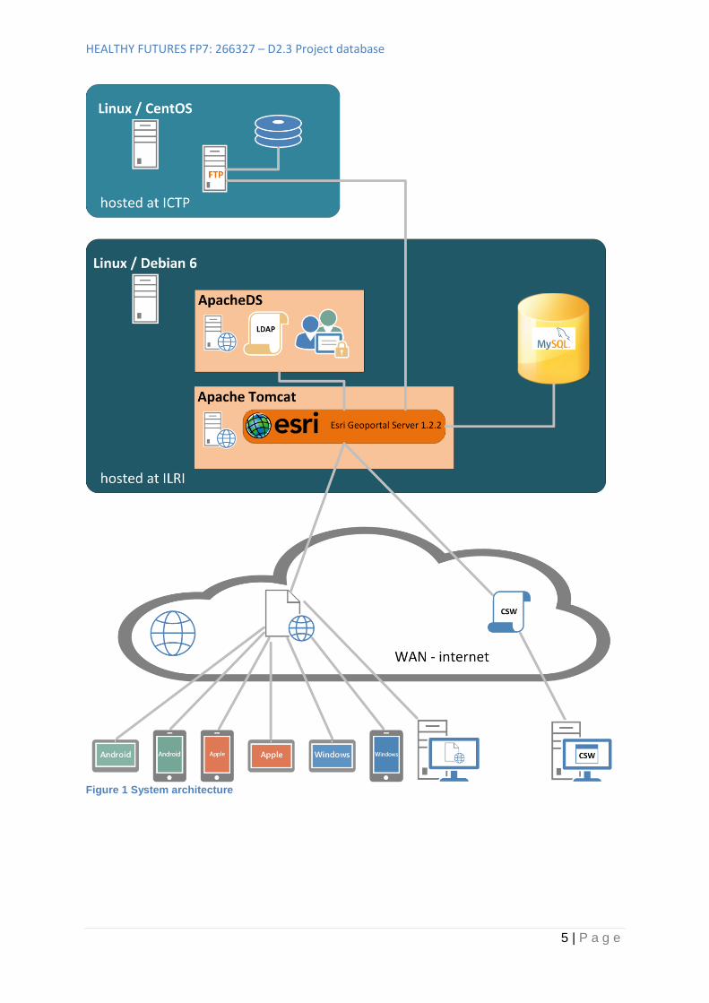
4 Technical Implementation The system and all depending applications which run this metadata portal are set up and hosted at the International Livestock Research Institute (ILRI) in Nairobi, Kenya. The link to this portal is: http://41.204.190.50/geoportal/catalog/main/home.page. The Paris Lodron University of Salzburg (PLUS) performed the portal customisations and related programming. The data is stored in a File Transfer Protocol (FTP) system that is only accessible via the portal. The International Centre for Theoretical Physics (ICTP) hosts the FTP server, as this was the only institution with enough data storage space. A technical overview is presented in Figure 1. The software Geoportal Server uses US English and these terms are used in this document to keep the original wording and to find it in the folder structure.
HEALTHY FUTURES FP7: 266327 – D2.3 Project database
5 | P a g e
Figure 1 System architecture

HEALTHY FUTURES FP7: 266327 – D2.3 Project database
6 | P a g e
4.1 Linux Server / Debian 6 All components to run this metadata portal are hosted on a GNU/Linux server (a real physical machine) with Debian 6 as operating system. ILRI hosts and administrates/maintains this server. Debian is developed by Debian Project and is a free operating system (OS) that is called Debian GNU/Linux. The word “free” has here two meanings, first and most important it is free of charge and second it is open source, which means that you can adapt everything you like to your needs.
4.2 Apache Tomcat The installed version on this Linux server is Apache Tomcat 6.0.35. Apache Tomcat is software that is an open source web server and servlet container. The Apache Software Foundation offers this software free of charge. This server is not a physical server, but the software acts like a server on any server or client. The special thing about this web server is the possibility of hosting websites (HTTP server) as well as JavaScript files (JavaServer Pages that are translated into servlets) to display/execute them on client-side or to run tasks backend on the real Linux server. This web server provides a folder that can be accessed via the internet if the port is unlocked by the firewall. The Apache Tomcat offers several installation options. The server and especially the applications to run on this web server need a Java installation.
4.3 Esri Geoportal Server ESRI is an American company that develops geographic information system (GIS) software. ESRI is known for proprietary products but also for quality. ESRI developed the ESRI Geoportal Server that is a metadata storage system. The Geoportal Server is free of charge and open source. The server also follows the Catalogue Service for the Web standard (CSW) of the Open Geospatial Consortium (OGC). ESRI describes the Geoportal this way: “ESRI Geoportal Server is a free, open source product that enables discovery and use of geospatial resources including datasets, rasters, and Web services. It helps organizations manage and publish metadata for their geospatial resources to let users discover and connect to those resources. The Geoportal Server supports standards-based clearinghouse and metadata discovery applications.”1
4.3.1 Installation The Geoportal Server is packed into a Web application ARchive (WAR - file). To install it the .war file is put in the “webapps” folder of Apache Tomcat. The Tomcat must now be changed from stopped mode to the running mode. It is no problem if the tomcat is already running. After placing the .war file into this folder Apache Tomcat starts to deploy it and makes a new folder that is named with the name of the .war file. This creation process takes a while in the background. After approximately one minute, the installation is ready to use. By default, the Geoportal server uses a simple login feature that can be extended by the use of Lightweight Directory Access Protocol (LDAP). The Geoportal Server is now accessible via internet:
<servername> name of the server where the Apache Tomcat runs, locally this could be
localhost or the IP address (Internet Protocol, for example: 41.204.190.50).
1 http://www.esri.com/software/arcgis/geoportal
HEALTHY FUTURES FP7: 266327 – D2.3 Project database
7 | P a g e
8080 this is the default port of Apache Tomcat
http://<servername>:8080/geoportal/catalog/main/home.page
The HF portal is now available through:
http://41.204.190.50/geoportal/catalog/main/home.page
4.3.2 Configuration To make the Geoportal accessible from anywhere of the world via the internet, change the port to 80, this is the default port for HTTP and is open or needs to be set open if it is not by default in the firewall. The Uniform Resource Locator (URL) then changes because the port 80 does not need to be specified any longer and a specific IP instead of local host have to be taken.
http://41.204.190.50/geoportal/catalog/main/home.page
4.3.3 Customisation The Geoportal contains a Wiki where ESRI offers help for the customisation. The following topics have been customised by PLUS:
Theme: There is an option to apply a custom theme. Therefore, we have taken an existing
theme (a Cascading Style Sheets file (.css)) and applied the colours of the logo etc. The size
and type of the text can be adjusted as well as the position of the elements like the banner,
navigation bar or the footer. All design relevant modifications can be applied in this file.
gpt.xml: Here the LDAP adapter is registered, which manages user access. By default, a
simple adapter is preconfigured and used when first launching. The roles are defined inside
the xml file. When more people are using this, especially with online access, an LDAP
adapter solution is favoured.
gpt.properties: This is a file that associates textblocks to internal variables (placekeeper) that
are going to be represented on the final HTML side. There we made changes to make the
metadata requirements more comprehensive for the editors, or we adjusted general text
blocks like the footer.
Folder ‘catalog’: This folder contains all content that is presented when the Geoportal is
opened. Here is the place where the website content can be adjusted. The websites are
generated with JSP files that contains also Java code snippets.
HEALTHY FUTURES FP7: 266327 – D2.3 Project database
8 | P a g e
4.4 ApacheDS (LDAP) In order to use this Geoportal a Lightweight Directory Access Protocol (LDAP) authentication server is setup, in this case an Apache Directory Studio was chosen. The LDAP defines users and groups, the main user maintenance can be done in the Geoportal itself, which user belongs to which group. The groups also indicate the access level, normally starting from a registered user, to an editor and finally a reviewer. In this Geoportal the reviewer is also the administrator.
4.5 Linux Server / CentOS – FTP ICTP hosts the FTP server. The server is used in this project to store data that belongs to the metadata. The decision not to host it on the ILRI server was made because of the expected big amount of data and the slow internet connection. One big advantage is also that ICTP already hosts a large amount of climate data which therefore do not have to be moved. PLUS implemented the FTP upload functionality into Geoportal Server. The editor of a metadata entry can now directly upload data that belongs to this metadata. First the data has to be selected on the local computer. After selecting, the editor presses the upload button and the data are immediately available online. The data stored with the FTP can be accessed from the website (http://clima-dods.ictp.it/d10/HEALTHY_FUTURES/FTP_UPLOAD/ ) for viewing and downloading data but uploading new data is only possible if you are logged in and use an ftp program. The login process and uploading data is done by a JSP file that cannot be accessed online.
4.6 MySQL The Geoportal Server uses a MySQL database. The Geoportal could also use different up-to-date databases, but ILRI has decided to use this database. When downloading the Geoportal Server several database scripts are included that contain different SQL statements to create the required tables.
5 Conclusion The HEALTHY FUTURES metadata portal is currently available and will now be filled with data entries by the different partners in the consortium. Therefore a user manual has been designed which is attached to this deliverable as Annex 1. Once the database is filled, the portal will be made accessible to the public which will be accompanied by dissemination in different newsletters etc. Currently links have been established to the Eastern African Community (EAC) and its activities in regard to climate change adaptation to maintain long term sustainability of the portal.
HEALTHY FUTURES FP7: 266327 – D2.3 Project database
9 | P a g e
6 ANNEX 1
FUTURE WITH GEOINFORMATION > www.uni-salzburg.at/zgis/
Salzburg, 21.03.2014
Metadata
Catalogue
Editor manual
Organisation Paris-Lodron Universität Salzburg (PLUS)
Department of Geoinformatics (Z_GIS)
International Livestock Research Organisation
(ILRI)
University of Rwanda, Centre for Geographic
Information Systems (UR-CGIS)
Author(s) Richard Schörghofer
Stefan Kienberger
Period 06-12/2013
Delivery date 25.02.2014
Status V2
Distribution level Project Internal
European Union’s Seventh Framework Programme (FP7/2007-2013)
The research leading to these results has received funding from the European Union’s Seventh Framework Programme (FP7/2007-2013)
FUTURE WITH GEOINFORMATION > www.uni-salzburg.at/zgis/ 2
"The only way to discover the limits of the possible
is to go beyond them into the impossible"
(Arthur C. Clarke)
For Data Publisher
Table of Contents
TABLE OF CONTENTS ........................................................................................................................................ 2
1 INTRODUCTION ....................................................................................................................................... 3
2 ADD AND MANAGE THE METADATA ....................................................................................................... 4
2.1 ADD/CREATE OR UPLOAD NEW METADATA ...................................................................................................... 4
Add metadata manually ................................................................................................................................. 5
Enter/Change metadata ................................................................................................................................. 7
Upload existing metadata to the geoportal ................................................................................................. 10
2.2 MANAGE YOUR METADATA ........................................................................................................................ 11
3 SEARCH METADATA ...............................................................................................................................13
Step1: Navigate to the search page .............................................................................................................. 13
Step2: Execute the search ............................................................................................................................. 14
4 STANDARD VALIDATION OF A XML FILE TO UPLOAD TO THE GEOPORTAL..............................................15
Step1: Select the file ...................................................................................................................................... 15
Step2: Validation........................................................................................................................................... 15
5 OTHER INFORMATION ............................................................................................................................17
Personal Information .................................................................................................................................... 17
6 CONTACT ................................................................................................................................................18
FUTURE WITH GEOINFORMATION > www.uni-salzburg.at/zgis/ 3
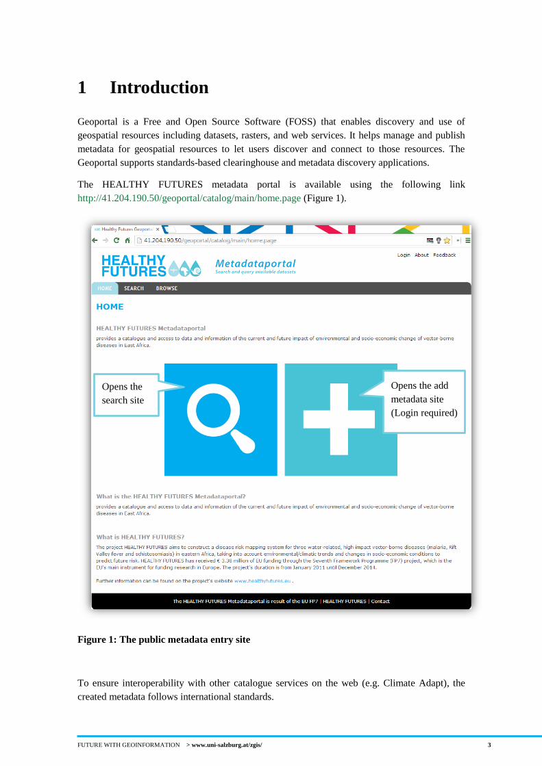
1 Introduction
Geoportal is a Free and Open Source Software (FOSS) that enables discovery and use of
geospatial resources including datasets, rasters, and web services. It helps manage and publish
metadata for geospatial resources to let users discover and connect to those resources. The
Geoportal supports standards-based clearinghouse and metadata discovery applications.
The HEALTHY FUTURES metadata portal is available using the following link
http://41.204.190.50/geoportal/catalog/main/home.page (Figure 1).
Figure 1: The public metadata entry site
To ensure interoperability with other catalogue services on the web (e.g. Climate Adapt), the
created metadata follows international standards.
Opens the
search site
Opens the add
metadata site
(Login required)
FUTURE WITH GEOINFORMATION > www.uni-salzburg.at/zgis/ 4
The ISO 19139 Metadata Standard has been taken and extended to achieve the potential
connection to other portals.
Searches on all publicly available metadata entries can be requested without registering at the
application as shown in Figure 18. Subsequently, search results are presented in a list. By
default a metadata record is presented in "simple-view" presenting only the abstract and some
contact info. By choosing another view-mode the user is able to view all the entered attributes.
2 Add and manage the metadata
This section includes a description on how to add new metadata records. It is possible to create
this manually step-by-step or to upload existing metadata information directly as a XML
file.There is also a description on how to edit your created metadata entries.
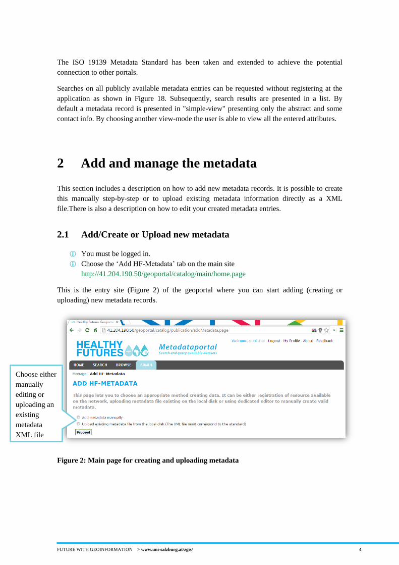
2.1 Add/Create or Upload new metadata
You must be logged in.
Choose the ‘Add HF-Metadata’ tab on the main site
http://41.204.190.50/geoportal/catalog/main/home.page
This is the entry site (Figure 2) of the geoportal where you can start adding (creating or
uploading) new metadata records.
Figure 2: Main page for creating and uploading metadata
Choose either
manually
editing or
uploading an
existing
metadata
XML file
FUTURE WITH GEOINFORMATION > www.uni-salzburg.at/zgis/ 5
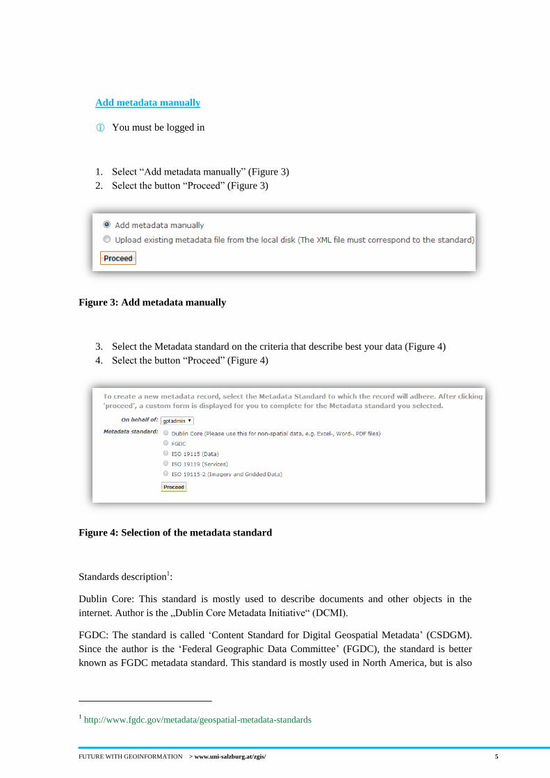
Add metadata manually
You must be logged in
1. Select “Add metadata manually” (Figure 3)
2. Select the button “Proceed” (Figure 3)
Figure 3: Add metadata manually
3. Select the Metadata standard on the criteria that describe best your data (Figure 4)
4. Select the button “Proceed” (Figure 4)
Figure 4: Selection of the metadata standard
Standards description1:
Dublin Core: This standard is mostly used to describe documents and other objects in the
internet. Author is the „Dublin Core Metadata Initiative“ (DCMI).
FGDC: The standard is called ‘Content Standard for Digital Geospatial Metadata’ (CSDGM).
Since the author is the ‘Federal Geographic Data Committee’ (FGDC), the standard is better
known as FGDC metadata standard. This standard is mostly used in North America, but is also
1 http://www.fgdc.gov/metadata/geospatial-metadata-standards
FUTURE WITH GEOINFORMATION > www.uni-salzburg.at/zgis/ 6
used in the rest of the world. The newest FGDC standard generation will be based on ISO
19115.
ISO 19115: The basic ISO metadata standard for the description of geographic information and
services.
ISO 19119: Extensions of the service metadata model. An affiliate standard that supports the
detailed description of digital geospatial services including geospatial data portals, web
mapping applications, data models and online data processing services. The standard can be
used in conjunction with ISO 19115 to document services associated with a specific data
set/series or independently to document a service.
ISO 19115 – 2: Extensions for imagery and gridded data. The basic ISO 19115 metadata
standard plus extended elements for the description of imagery, gridded data and data collected
using instruments, e.g. monitoring stations and measurement devices. These extensions also
include improved descriptions of lineage and processing information.
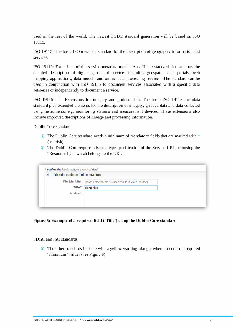
Dublin Core standard:
The Dublin Core standard needs a minimum of mandatory fields that are marked with *
(asterisk)
The Dublin Core requires also the type specification of the Service URL, choosing the
“Resource Typ” which belongs to the URL
Figure 5: Example of a required field (‘Title’) using the Dublin Core standard
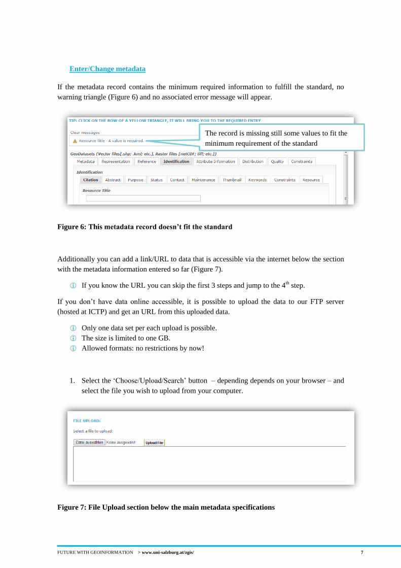
FDGC and ISO standards:
The other standards indicate with a yellow warning triangle where to enter the required
“minimum” values (see Figure 6)
FUTURE WITH GEOINFORMATION > www.uni-salzburg.at/zgis/ 7
Enter/Change metadata
If the metadata record contains the minimum required information to fulfill the standard, no
warning triangle (Figure 6) and no associated error message will appear.
Figure 6: This metadata record doesn’t fit the standard
Additionally you can add a link/URL to data that is accessible via the internet below the section
with the metadata information entered so far (Figure 7).
If you know the URL you can skip the first 3 steps and jump to the 4th step.
If you don’t have data online accessible, it is possible to upload the data to our FTP server
(hosted at ICTP) and get an URL from this uploaded data.
Only one data set per each upload is possible.
The size is limited to one GB.
Allowed formats: no restrictions by now!
1. Select the ‘Choose/Upload/Search’ button – depending depends on your browser – and
select the file you wish to upload from your computer.
Figure 7: File Upload section below the main metadata specifications
The record is missing still some values to fit the
minimum requirement of the standard
FUTURE WITH GEOINFORMATION > www.uni-salzburg.at/zgis/ 8
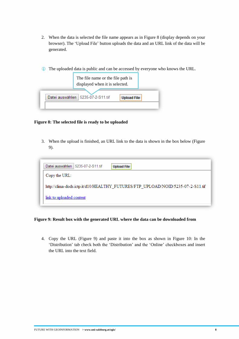
2. When the data is selected the file name appears as in Figure 8 (display depends on your
browser). The ‘Upload File’ button uploads the data and an URL link of the data will be
generated.
The uploaded data is public and can be accessed by everyone who knows the URL.
Figure 8: The selected file is ready to be uploaded
3. When the upload is finished, an URL link to the data is shown in the box below (Figure
9).
Figure 9: Result box with the generated URL where the data can be downloaded from
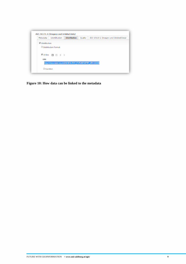
4. Copy the URL (Figure 9) and paste it into the box as shown in Figure 10: In the
‘Distribution’ tab check both the ‘Distribution’ and the ‘Online’ checkboxes and insert
the URL into the text field.
The file name or the file path is
displayed when it is selected.
FUTURE WITH GEOINFORMATION > www.uni-salzburg.at/zgis/ 9
Figure 10: How data can be linked to the metadata
FUTURE WITH GEOINFORMATION > www.uni-salzburg.at/zgis/ 10
Upload existing metadata to the geoportal
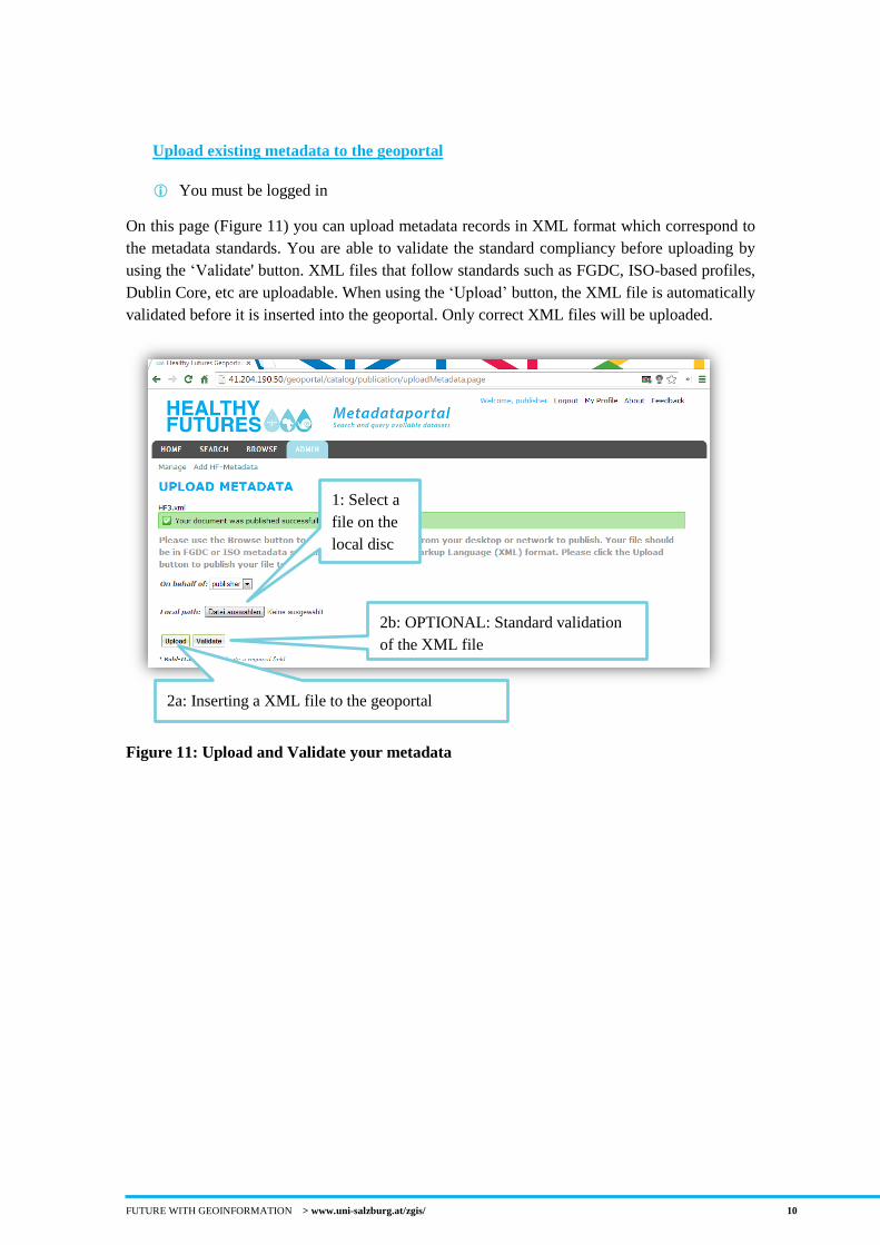
You must be logged in
On this page (Figure 11) you can upload metadata records in XML format which correspond to
the metadata standards. You are able to validate the standard compliancy before uploading by
using the ‘Validate' button. XML files that follow standards such as FGDC, ISO-based profiles,
Dublin Core, etc are uploadable. When using the ‘Upload’ button, the XML file is automatically
validated before it is inserted into the geoportal. Only correct XML files will be uploaded.
Figure 11: Upload and Validate your metadata
1: Select a
file on the
local disc
2a: Inserting a XML file to the geoportal
2b: OPTIONAL: Standard validation
of the XML file
FUTURE WITH GEOINFORMATION > www.uni-salzburg.at/zgis/ 11
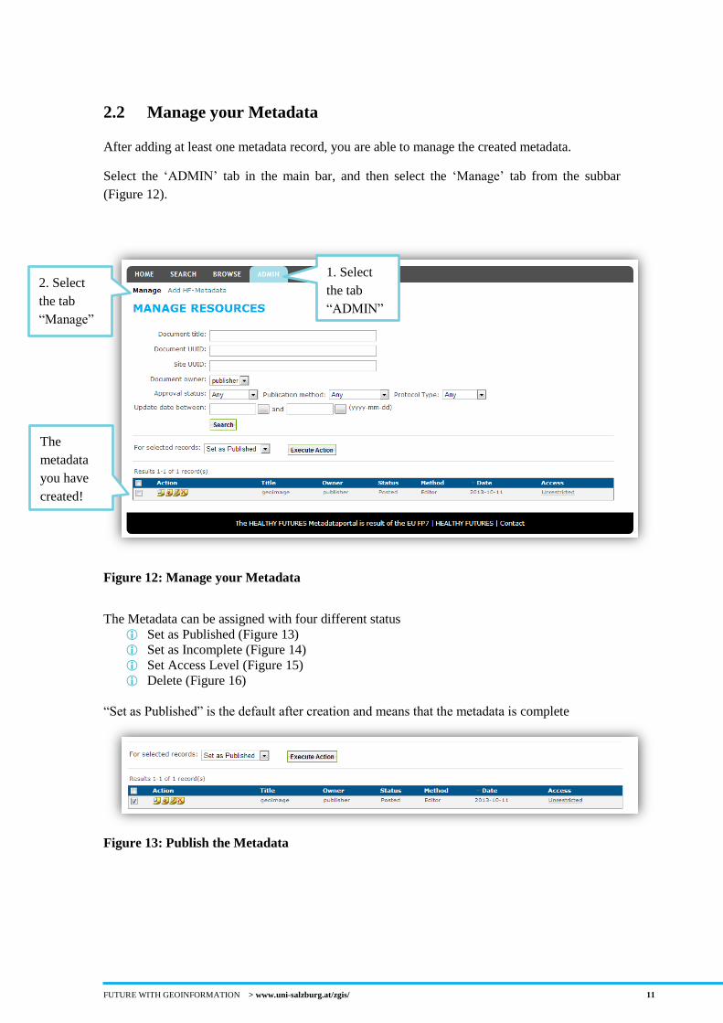
2.2 Manage your Metadata
After adding at least one metadata record, you are able to manage the created metadata.
Select the ‘ADMIN’ tab in the main bar, and then select the ‘Manage’ tab from the subbar
(Figure 12).
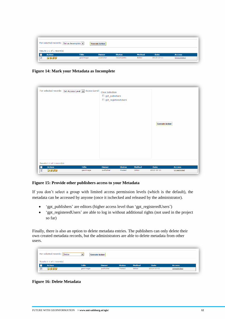
Figure 12: Manage your Metadata
The Metadata can be assigned with four different status
Set as Published (Figure 13)
Set as Incomplete (Figure 14)
Set Access Level (Figure 15)
Delete (Figure 16)
“Set as Published” is the default after creation and means that the metadata is complete
Figure 13: Publish the Metadata
The
metadata
you have
created!
2. Select
the tab
“Manage”
1. Select
the tab
“ADMIN”
FUTURE WITH GEOINFORMATION > www.uni-salzburg.at/zgis/ 12
Figure 14: Mark your Metadata as Incomplete
Figure 15: Provide other publishers access to your Metadata
If you don’t select a group with limited access permission levels (which is the default), the
metadata can be accessed by anyone (once it ischecked and released by the administrator).
‘gpt_publishers’ are editors (higher access level than ‘gpt_registeredUsers’)
‘gpt_registeredUsers’ are able to log in without additional rights (not used in the project
so far)
Finally, there is also an option to delete metadata entries. The publishers can only delete their
own created metadata records, but the administrators are able to delete metadata from other
users.
Figure 16: Delete Metadata
FUTURE WITH GEOINFORMATION > www.uni-salzburg.at/zgis/ 13
3 Search Metadata
No Login required to see approved metadata records
With Login, all metadata records are displayed
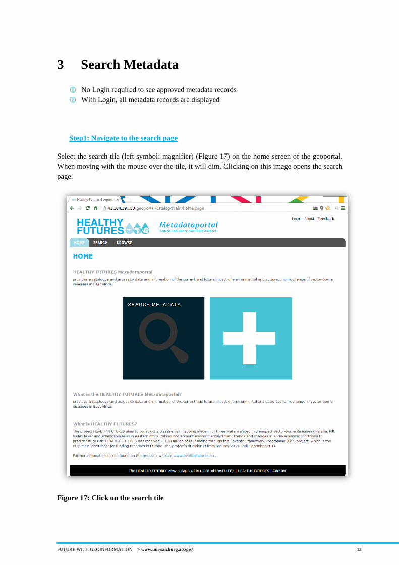
Step1: Navigate to the search page
Select the search tile (left symbol: magnifier) (Figure 17) on the home screen of the geoportal.
When moving with the mouse over the tile, it will dim. Clicking on this image opens the search
page.
Figure 17: Click on the search tile
FUTURE WITH GEOINFORMATION > www.uni-salzburg.at/zgis/ 14
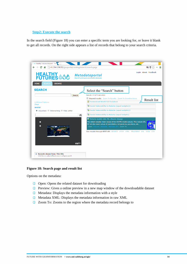
Step2: Execute the search
In the search field (Figure 18) you can enter a specific term you are looking for, or leave it blank
to get all records. On the right side appears a list of records that belong to your search criteria.
Figure 18: Search page and result list
Options on the metadata:
Open: Opens the related dataset for downloading
Preview: Gives a online preview in a new map window of the downloadable dataset
Metadata: Displays the metadata information with a style
Metadata XML: Displays the metadata information in raw XML
Zoom To: Zooms to the region where the metadata record belongs to
Select the “Search” button
Result list
FUTURE WITH GEOINFORMATION > www.uni-salzburg.at/zgis/ 15
4 Standard validation of a XML file to upload
to the geoportal
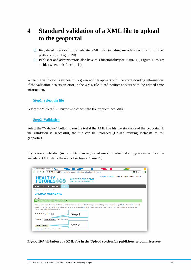
Registered users can only validate XML files (existing metadata records from other
platforms) (see Figure 20)
Publisher and administrators also have this functionality(see Figure 19, Figure 11 to get
an idea where this function is)
When the validation is successful, a green notifier appears with the corresponding information.
If the validation detects an error in the XML file, a red notifier appears with the related error
information.
Step1: Select the file
Select the “Select file” button and choose the file on your local disk.
Step2: Validation
Select the “Validate” button to run the test if the XML file fits the standards of the geoportal. If
the validation is successful, the file can be uploaded (Upload existing metadata to the
geoportal).
If you are a publisher (more rights than registered users) or administrator you can validate the
metadata XML file in the upload section. (Figure 19)
Figure 19:Validation of a XML file in the Upload section for publishers or administrator
Step 1
Step 2
FUTURE WITH GEOINFORMATION > www.uni-salzburg.at/zgis/ 16
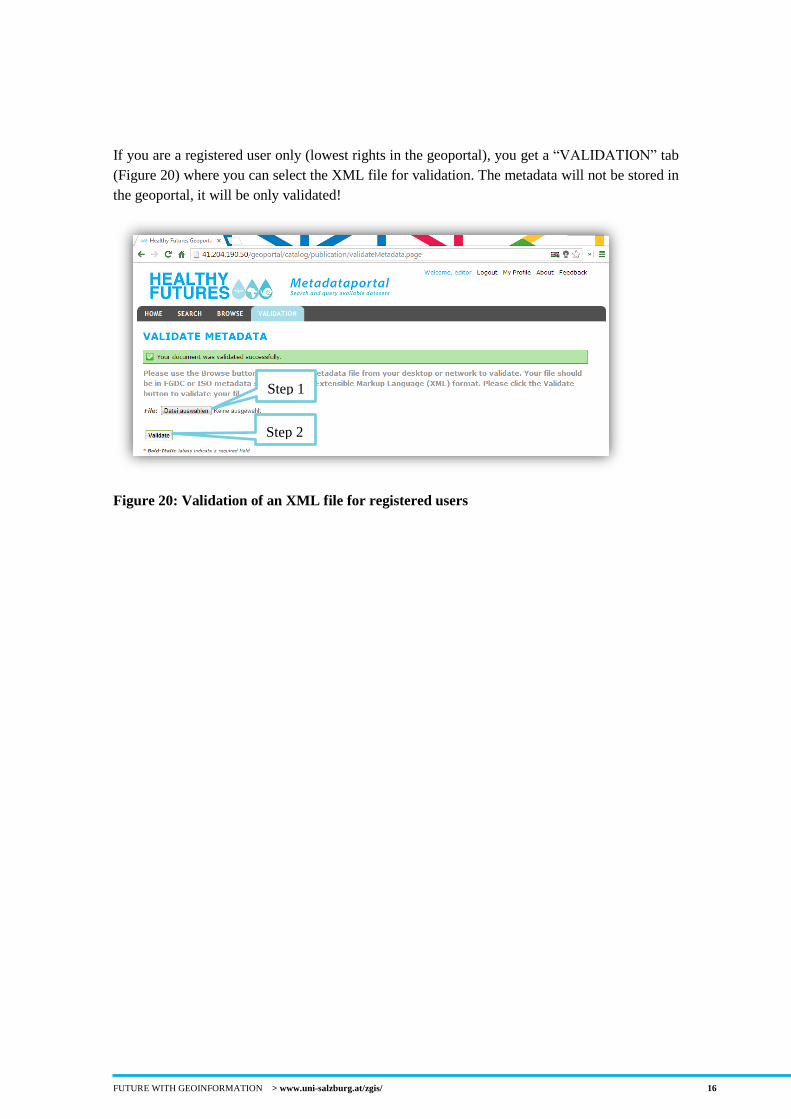
If you are a registered user only (lowest rights in the geoportal), you get a “VALIDATION” tab
(Figure 20) where you can select the XML file for validation. The metadata will not be stored in
the geoportal, it will be only validated!
Figure 20: Validation of an XML file for registered users
Step 1
Step 2
FUTURE WITH GEOINFORMATION > www.uni-salzburg.at/zgis/ 17
5 Other Information
Personal Information
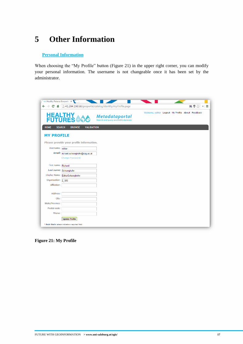
When choosing the “My Profile” button (Figure 21) in the upper right corner, you can modify
your personal information. The username is not changeable once it has been set by the
administrator.
Figure 21: My Profile
FUTURE WITH GEOINFORMATION > www.uni-salzburg.at/zgis/ 18
6 Contact
Richard Schörghofer
University of Salzburg
Interfaculty Department of Geoinformatics
[T] +43 662 8044 7592
Dr. Stefan Kienberger
University of Salzburg
Interfaculty Department of Geoinformatics
[T] +43 662 8044 7567