Hornsea Offshore Wind Farm Project One - Planning … Offshore Wind Farm Project One Environmental...
21
Hornsea Offshore Wind Farm Project One Environmental Statement Volume 6 – Onshore Annex 6.3.2 Phase 1 Intertidal, Sand Dune and Salt Marsh Phase 1 Habitat Survey PINS Document Reference: 7.6.3.2 APFP Regulation 5(2)(a) July 2013
Transcript of Hornsea Offshore Wind Farm Project One - Planning … Offshore Wind Farm Project One Environmental...
Hornsea Offshore Wind Farm Project One
Environmental Statement Volume 6 – Onshore
Annex 6.3.2 Phase 1 Intertidal, Sand Dune
and Salt Marsh Phase 1 Habitat Survey
PINS Document Reference: 7.6.3.2
APFP Regulation 5(2)(a)
July 2013
sdf
i
SMart Wind Limited Hornsea Offshore Wind Farm Project One – Environmental Statement Volume 6 Annex 6.3.2 – Intertidal, Sand Dune and Salt Marsh Phase 1 Habitat Survey
SMart Wind Limited 11th Floor 140 London Wall London EC2Y 5DN Tel 0207 7765500 Email [email protected]
Copyright © 2013 All pre-existing rights reserved.
Liability This report has been prepared by RPS, with all reasonable skill, care and diligence within the terms of their contracts with SMart Wind Ltd or their subcontractor to RPS placed under RPS’ contract with SMart Wind Ltd as the case may be.
Document release and authorisation record
PINS Document Reference 7.6.3.2
Report Number UK04-050700-REP-0023
Date July 2013
Client Name SMart Wind Limited
Client contact(s)
Chris Jenner Penny Pickett Rachael Mills Rosemary Tingle Liam Leahy Sheelagh Guilmartin Ditte Bilde

sdf
ii
Table of Contents
1 Introduction .......................................................................................................................... 1
1.1 Background to the Project ..................................................................................... 1
1.2 Scope of Survey ................................................................................................... 1
1.3 Survey Objectives ................................................................................................. 1
1.4 Horseshoe Point ................................................................................................... 1
2 Methodology ........................................................................................................................ 3
2.1 Lower Intertidal Phase 1 Habitat Survey ............................................................... 3
2.2 Upper Intertidal Phase 1 Habitat Survey ............................................................... 3
2.3 Timing ................................................................................................................... 3
3 Results ................................................................................................................................. 4
3.1 Site Context .......................................................................................................... 4
3.2 Intertidal Biotopes ................................................................................................. 4
3.3 Intertidal Survey Limitations .................................................................................. 4
3.4 Upper Intertidal Habitat Survey Findings .............................................................. 7
3.5 Fauna .................................................................................................................. 11
4 Discussion ......................................................................................................................... 13
4.1 Habitats ............................................................................................................... 13
5 Conclusion and Recommendations ................................................................................... 16
6 References ........................................................................................................................ 17
Table of Figures
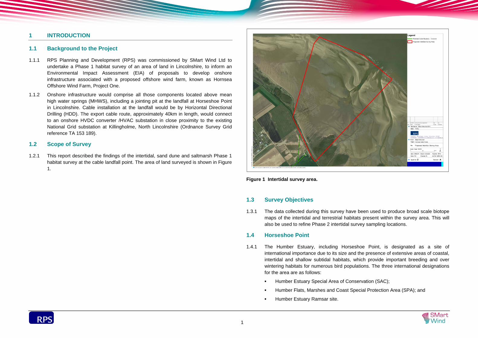
Figure 1 Intertidal survey area..................................................................................................... 1
Figure 2 Horseshoe Point landfall survey – intertidal habitats. .................................................... 5
Figure 3 Horseshoe Point landfall survey – terrestrial habitats. .................................................. 7
Table of Plates
Plate 1 Main saltmarsh habitat in southern section of site. ........................................................ 8
Plate 2 Common cord-grass (northern edge of main block of saltmarsh). ................................. 8
Plate 3 Damaged upper saltmarsh vegetation (vehicle access). ................................................ 8
Plate 4 Linear sand dune habitat showing semi-fixed and embryo dune habitat. ....................... 9
Plate 5 Saltmarsh / sand transition ........................................................................................... 10
sdf
iii
Table of Tables
Table 1 International designations in the vicinity of the Hornsea proposed cable landfall site at
Horseshoe Point. ................................................................................................... 2
Table 2 Low tide times at Immingham, 5th and 6th July 2011. .................................................. 3
Table 3 Littoral Biotopes recorded (adapted from Connor et al., 2004). .................................... 6
Acronyms
Acronym Full term
EIA Environmental Impact Assessment
HDD Horizontal Directional Drilling
JNCC Joint Nature Conservation Committee
RPS RPS Planning and Development
SAC Special Area of Conservation
SPA Special Protection Area
WCA 1981 Wildlife and Countryside Act 1981 (as amended)
sdf
1
1 INTRODUCTION
1.1 Background to the Project
1.1.1 RPS Planning and Development (RPS) was commissioned by SMart Wind Ltd to undertake a Phase 1 habitat survey of an area of land in Lincolnshire, to inform an Environmental Impact Assessment (EIA) of proposals to develop onshore infrastructure associated with a proposed offshore wind farm, known as Hornsea Offshore Wind Farm, Project One.
1.1.2 Onshore infrastructure would comprise all those components located above mean high water springs (MHWS), including a jointing pit at the landfall at Horseshoe Point in Lincolnshire. Cable installation at the landfall would be by Horizontal Directional Drilling (HDD). The export cable route, approximately 40km in length, would connect to an onshore HVDC converter /HVAC substation in close proximity to the existing National Grid substation at Killingholme, North Lincolnshire (Ordnance Survey Grid reference TA 153 189).
1.2 Scope of Survey
1.2.1 This report described the findings of the intertidal, sand dune and saltmarsh Phase 1 habitat survey at the cable landfall point. The area of land surveyed is shown in Figure 1.
Figure 1 Intertidal survey area.
1.3 Survey Objectives
1.3.1 The data collected during this survey have been used to produce broad scale biotope maps of the intertidal and terrestrial habitats present within the survey area. This will also be used to refine Phase 2 intertidal survey sampling locations.
1.4 Horseshoe Point
1.4.1 The Humber Estuary, including Horseshoe Point, is designated as a site of international importance due to its size and the presence of extensive areas of coastal, intertidal and shallow subtidal habitats, which provide important breeding and over wintering habitats for numerous bird populations. The three international designations for the area are as follows:
Humber Estuary Special Area of Conservation (SAC);
Humber Flats, Marshes and Coast Special Protection Area (SPA); and
Humber Estuary Ramsar site.
sdf
2
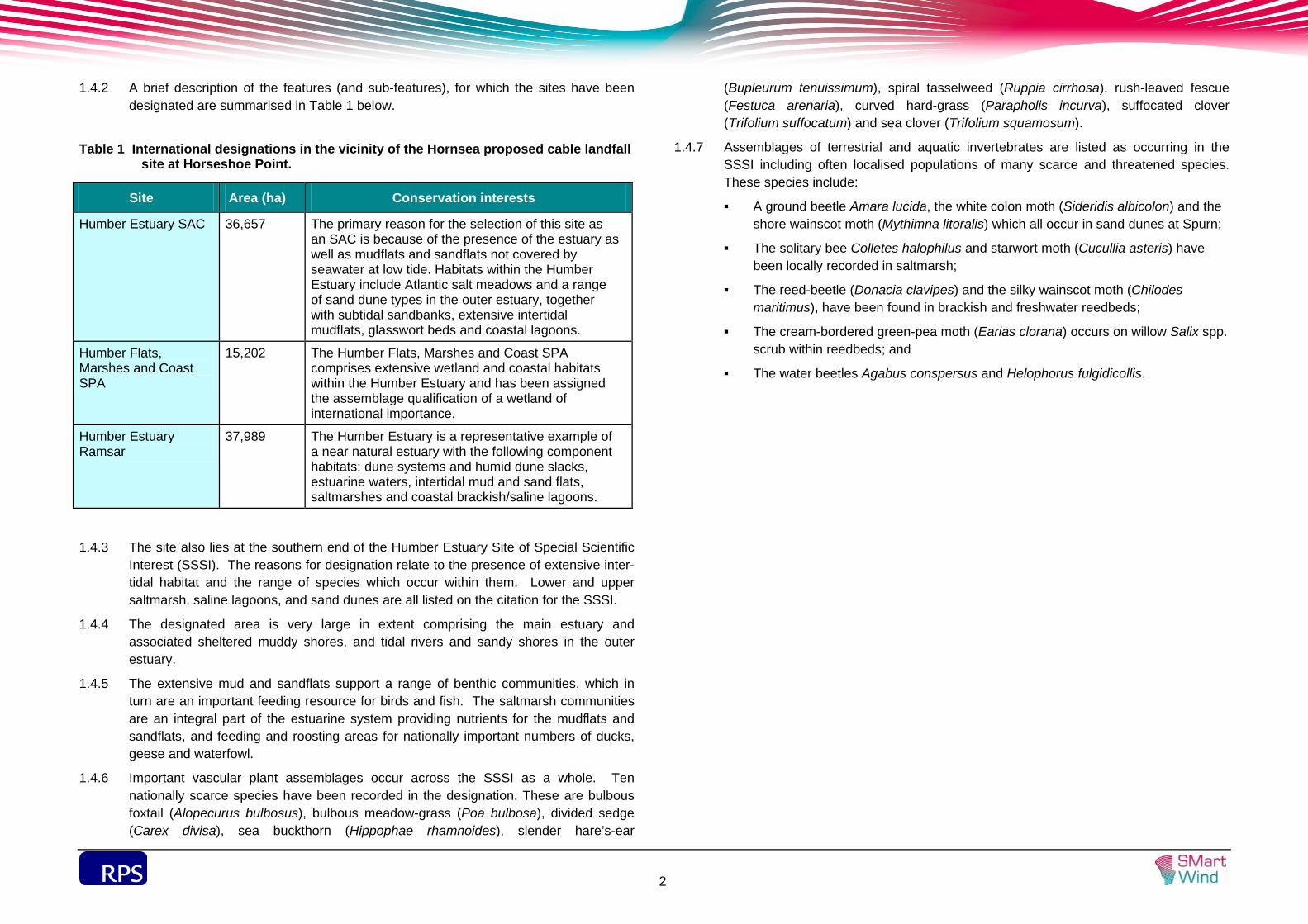
1.4.2 A brief description of the features (and sub-features), for which the sites have been designated are summarised in Table 1 below.
Table 1 International designations in the vicinity of the Hornsea proposed cable landfall
site at Horseshoe Point.
Site Area (ha) Conservation interests
Humber Estuary SAC 36,657 The primary reason for the selection of this site as an SAC is because of the presence of the estuary as well as mudflats and sandflats not covered by seawater at low tide. Habitats within the Humber Estuary include Atlantic salt meadows and a range of sand dune types in the outer estuary, together with subtidal sandbanks, extensive intertidal mudflats, glasswort beds and coastal lagoons.
Humber Flats, Marshes and Coast SPA
15,202 The Humber Flats, Marshes and Coast SPA comprises extensive wetland and coastal habitats within the Humber Estuary and has been assigned the assemblage qualification of a wetland of international importance.
Humber Estuary Ramsar
37,989 The Humber Estuary is a representative example of a near natural estuary with the following component habitats: dune systems and humid dune slacks, estuarine waters, intertidal mud and sand flats, saltmarshes and coastal brackish/saline lagoons.
1.4.3 The site also lies at the southern end of the Humber Estuary Site of Special Scientific Interest (SSSI). The reasons for designation relate to the presence of extensive inter-tidal habitat and the range of species which occur within them. Lower and upper saltmarsh, saline lagoons, and sand dunes are all listed on the citation for the SSSI.
1.4.4 The designated area is very large in extent comprising the main estuary and associated sheltered muddy shores, and tidal rivers and sandy shores in the outer estuary.
1.4.5 The extensive mud and sandflats support a range of benthic communities, which in turn are an important feeding resource for birds and fish. The saltmarsh communities are an integral part of the estuarine system providing nutrients for the mudflats and sandflats, and feeding and roosting areas for nationally important numbers of ducks, geese and waterfowl.
1.4.6 Important vascular plant assemblages occur across the SSSI as a whole. Ten nationally scarce species have been recorded in the designation. These are bulbous foxtail (Alopecurus bulbosus), bulbous meadow-grass (Poa bulbosa), divided sedge (Carex divisa), sea buckthorn (Hippophae rhamnoides), slender hare’s-ear
(Bupleurum tenuissimum), spiral tasselweed (Ruppia cirrhosa), rush-leaved fescue (Festuca arenaria), curved hard-grass (Parapholis incurva), suffocated clover (Trifolium suffocatum) and sea clover (Trifolium squamosum).
1.4.7 Assemblages of terrestrial and aquatic invertebrates are listed as occurring in the SSSI including often localised populations of many scarce and threatened species. These species include:
A ground beetle Amara lucida, the white colon moth (Sideridis albicolon) and the shore wainscot moth (Mythimna litoralis) which all occur in sand dunes at Spurn;
The solitary bee Colletes halophilus and starwort moth (Cucullia asteris) have been locally recorded in saltmarsh;
The reed-beetle (Donacia clavipes) and the silky wainscot moth (Chilodes maritimus), have been found in brackish and freshwater reedbeds;
The cream-bordered green-pea moth (Earias clorana) occurs on willow Salix spp. scrub within reedbeds; and
The water beetles Agabus conspersus and Helophorus fulgidicollis.
sdf
3
2 METHODOLOGY
2.1 Lower Intertidal Phase 1 Habitat Survey
2.1.1 A lower intertidal Phase 1 walkover survey was conducted between the 5 and 6 July 2011 at the proposed cable route landfall site at Horseshoe Point, which covers a survey corridor at the mouth of the Humber Estuary (Figure 2) with a width of approximately 1km at the landward side and 2 km at mean low water.
2.1.2 The survey was conducted by suitably qualified marine ecologists and followed guidance set out in the Joint Nature Conservation Committee (JNCC) Marine Monitoring Handbook (Davies et al., 2001), i.e. Procedural Guideline No. 3-1 In situ intertidal biotope recording, and in the Handbook for Marine Intertidal Phase 1 Biotope Mapping Survey (Wyn et al., 2006).
2.1.3 The survey was conducted two hours either side of low tide to ensure that as much of the intertidal zone as possible was surveyed. Notes were made on the shore type, wave exposure, sediments/substrates present, descriptions of species/biotopes present and the spatial relationships between these. All biotopes present were identified and their extents mapped with the aid of aerial photography and using hand held GPS recorders. Notes were also made on the presence of features in the intertidal zone, e.g. shellfish beds, drainage channels, potential Annex I habitats (e.g. Sabellaria alveolata reefs), and, where present, these were target noted in the intertidal biotope map.
2.1.4 On-site sediment sampling and analysis was undertaken in soft sediment habitats, which involved the collection of two spade loads (approximately 0.02 m2) of sediment dug to a depth of 20-25 cm and sieved through a 0.5 mm mesh. All species present were identified and enumerated on site. As well as recording the species present and abundances, field notes were also made on the physical characteristics including sediment type and presence of anoxic layers in the sediment.
2.2 Upper Intertidal Phase 1 Habitat Survey
2.2.1 The survey of upper intertidal habitats was undertaken by an experienced terrestrial ecologist and coastal botanist. The walkover survey was conducted in accordance with The Handbook for Phase 1 Habitat Survey (Joint Nature Conservation Committee, 2010), and included searches for signs of protected species, as described in Guidelines for Baseline Ecological Assessment (Institute of Environmental Assessment, 1995). During the walkover of the site the vegetated habitats within the survey area were classified and described with respect to their structure and floristic composition.
2.2.2 Consideration was given to habitats adjoining the survey boundary in order to assess:
The ecological context of the survey area in the wider landscape; and
The likelihood of the site being used by protected or notable non-marine faunal species.
2.2.3 Signs indicating the presence of faunal species, such as droppings, burrows, tracks and evidence of feeding, were noted during the site walkover. Any features within the site with the potential to support legally protected or otherwise notable flora and non-marine fauna were also noted.
2.2.4 Any invasive non-native plant species listed on the revised Schedule 9 of the Wildlife and Countryside Act 1981 (as amended) (WCA 1981), adopted in April 2010, were identified and mapped. Botanical nomenclature in this report follows that laid out by Stace (1997).
2.3 Timing
2.3.1 The lower intertidal survey was undertaken during the optimal survey period for intertidal and saltmarsh biotope mapping surveys of April to October (Wyn et al., 2006) to allow for macroalgal and plant spring growth.
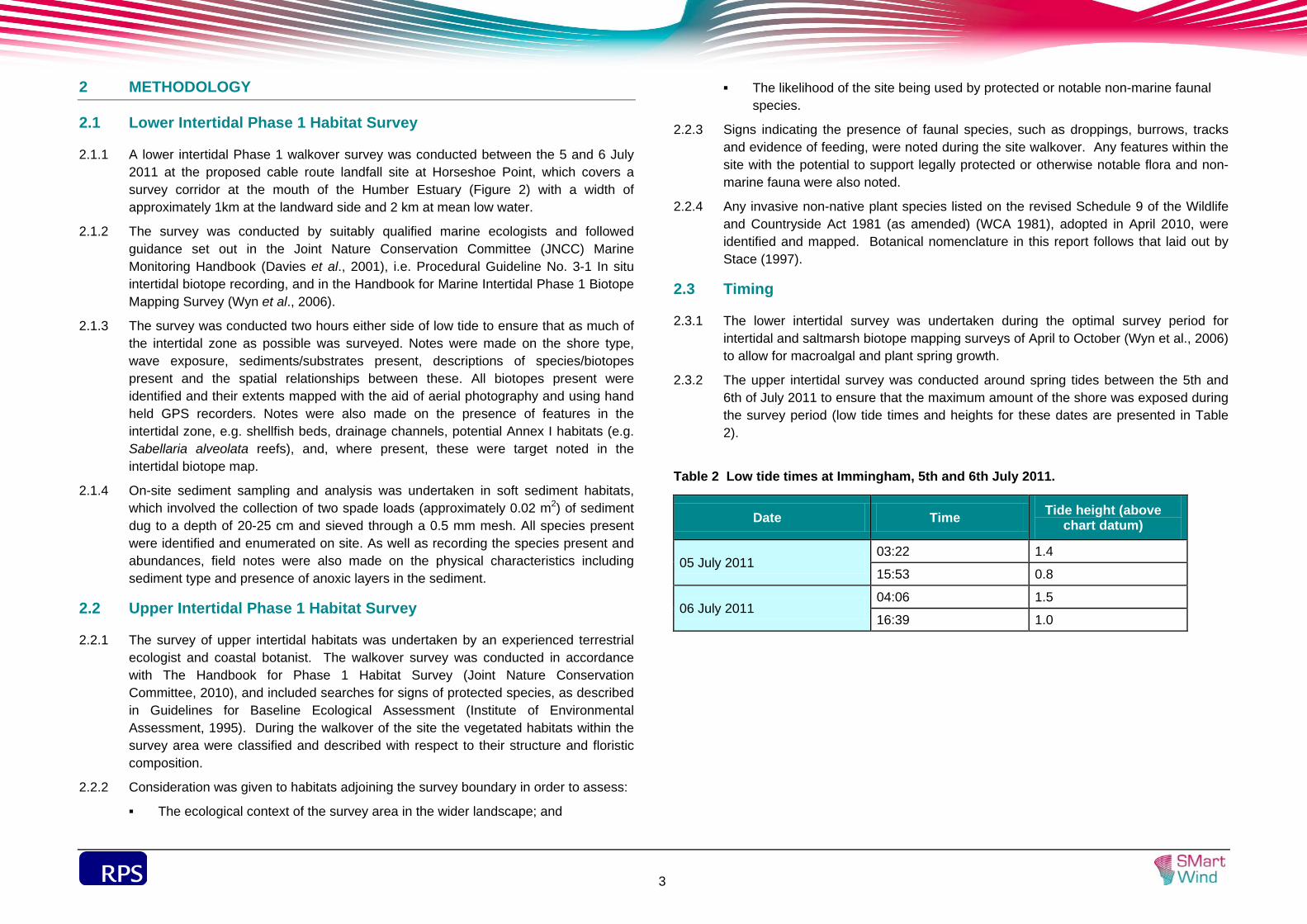
2.3.2 The upper intertidal survey was conducted around spring tides between the 5th and 6th of July 2011 to ensure that the maximum amount of the shore was exposed during the survey period (low tide times and heights for these dates are presented in Table 2).
Table 2 Low tide times at Immingham, 5th and 6th July 2011.
Date Time Tide height (above chart datum)
05 July 2011 03:22 1.4
15:53 0.8
06 July 2011 04:06 1.5
16:39 1.0

sdf
4
3 RESULTS
3.1 Site Context
3.1.1 The survey area at Horseshoe Point is primarily a large expanse of sandflat located between the sea wall and the low tide line. Saltmarsh habitat recorded within the survey area is continuous with extensive saltmarsh habitat in the outer estuary to the north and south.
3.1.2 The extent of saltmarsh habitat within the survey area is relatively small, but it is part of an extensive area of intertidal saltmarsh habitat which overlaps the survey area. Saltmarsh plants extend into the sandflat to the north-west of the main saltmarsh habitat.
3.1.3 Extensive saltmarsh lies outside the survey area to the northwest. Connected to this is a permanent open water channel bounded by saltmarsh vegetation and strip of mobile sand dune located between the saltmarsh and the sandflat. A further strip of sand dune habitat occurs on the seaward side of the southern section of the sea wall within the survey area.
3.1.4 Arable farmland lies inland of the survey area with a deep brackish ditch defining the arable field margin at the base of the landward side of the sea wall.
3.2 Intertidal Biotopes
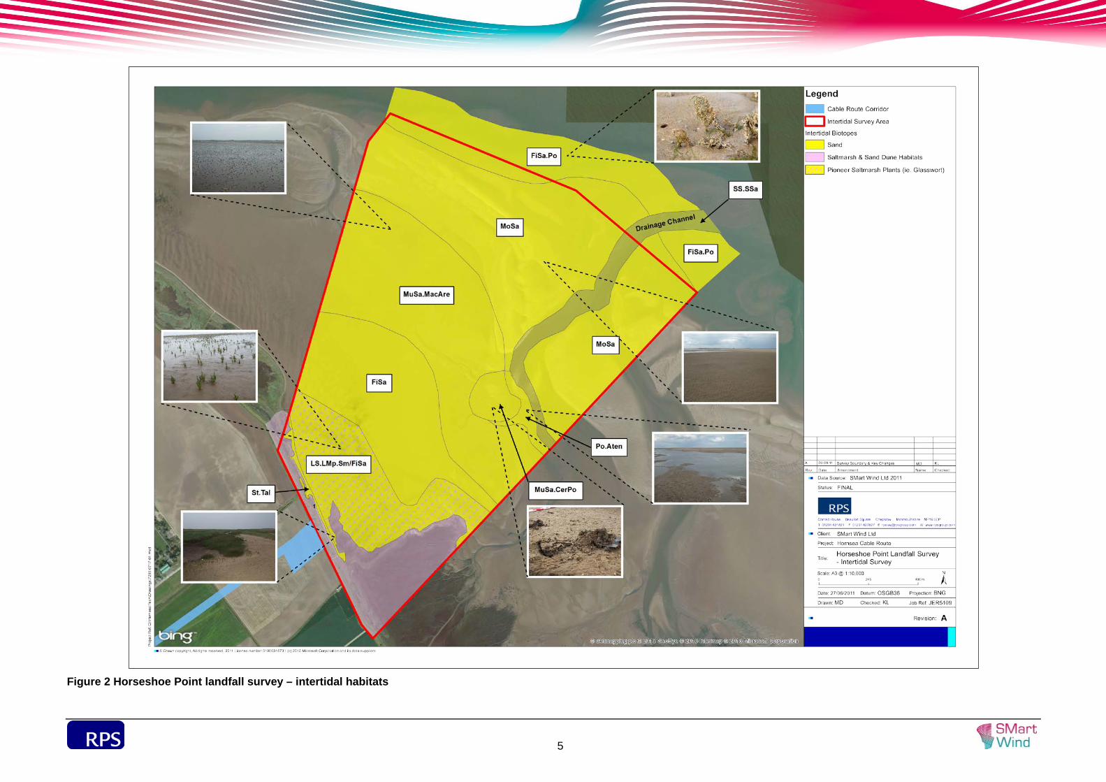
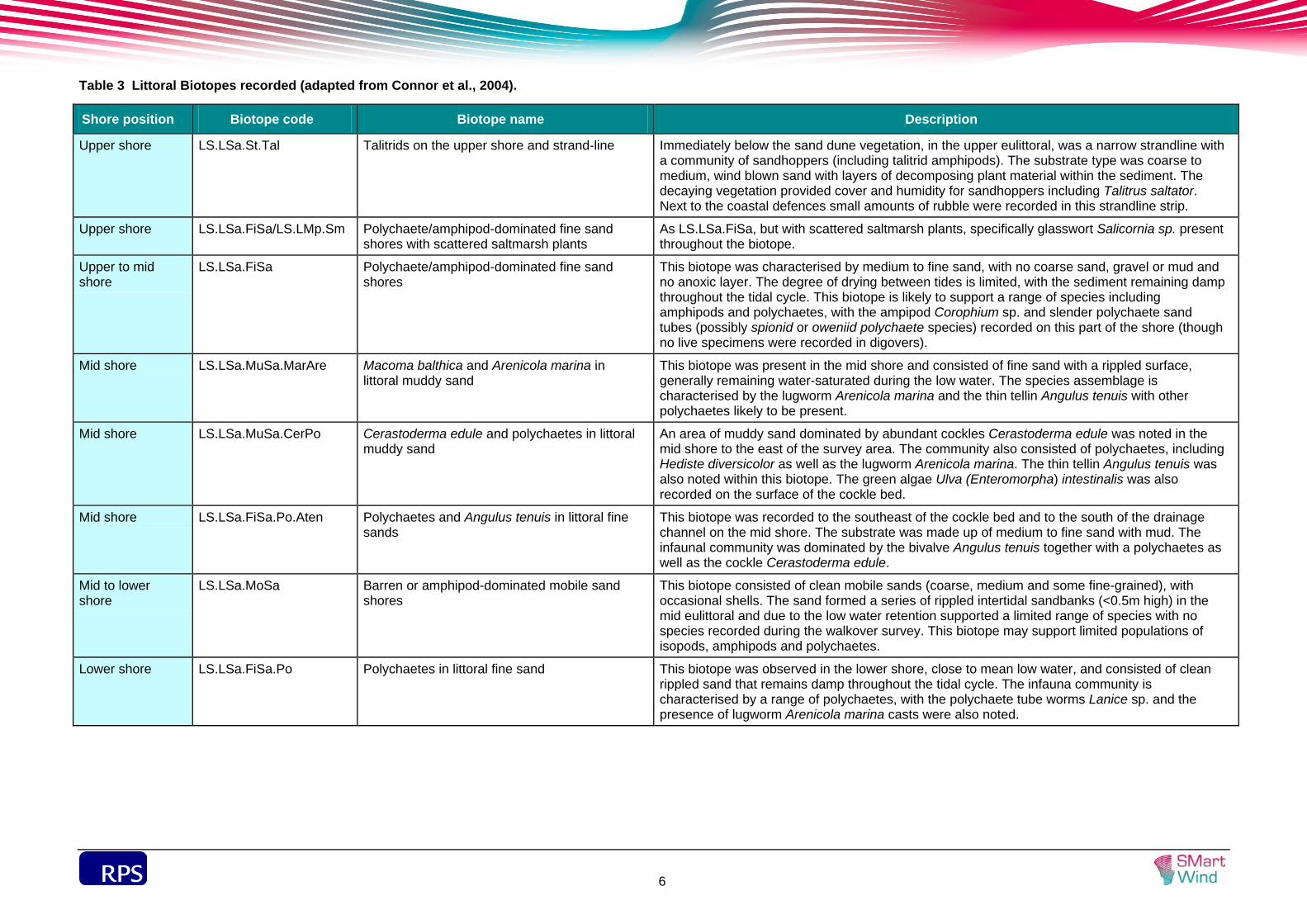
3.2.1 The lower intertidal zone was dominated by sandy sediments with areas of saltmarsh and sand dune habitats on the landward side of the shore (see Figure 2). Figure 2 presents the intertidal biotopes present at the intertidal landfall site and a description of each biotope is presented in Table 3 .
3.2.2 Immediately below the sand dune habitats, in the upper eulittoral, was a thin strandline of wind-blown sand and rotting detritus and vegetation with talitrid amphipods (LS.LSa.St.Tal). Immediately below this was an area of medium and fine sandy sediments which were characterised by tube building polychaetes and amphipods (LS.LSa.FiSa). Numerous polychaete tubes (possibly spionid or oweniid polychaete species) were recorded in the digover samples, though no actual polychaetes were recorded and therefore identification could not be confirmed. Approximately half of this biotope, on the landward side, was also characterised by scattered saltmarsh plants, i.e. glasswort Salicornia sp. typically measuring less than 5cm height, which were present at densities of 10 to 50 individual plants per m2.
3.2.3 Below this biotope was an area characterised by medium to fine sands with lugworm Arenicola marina at densities of 30 to 50 individuals per m2 (LS.LSa.MuSa.MacAre). Digover sampling also recorded the thin tellin Angulus tenuis, though at much lower densities. A small cockle bed Cerastoderma edule was recorded to the southeast of the LS.LSa.MuSa.MacAre biotope. In this biotope (LS.LSa.MuSa.CerPo), cockle
abundances of hundreds of individuals per m2 were recorded along with thin tellins and the polychaete Hediste diversicolor which were present at lower abundances. The green algae Ulva (Enteromorpha) was also recorded on the surface of the cockle bed.
3.2.4 Adjacent to the cockle bed at low tide was a drainage channel approximately 5 to 10 m wide, with a depth of 20 to 40 cm, flowing in a north to northeasterly direction into the sea. The sediments at the edge of this channel (adjacent to the cockle bed) were characterised by medium to fine sand with a small mud fraction. Species recorded in digover sampling were similar to those recorded in the cockle bed, though cockles were recorded at much lower abundances (LS.LSa.FiSa.Po.Aten). This biotope is often recorded in sandy sediments adjacent to cockle beds (Connor et al., 2004). The drainage channel was characterised by medium to fine sand. However no digovers were undertaken in the channel and as such no record of the species present was made.
3.2.5 An area of barren mobile sandy sediment, with occasional shells, formed into a series of rippled sandbanks approximately 0.5 m high was present either side of the drainage channel. No fauna was recorded in this biotope (LS.LSa.MoSa). It is likely that these sandbanks provide some shelter from wave action for the biotopes on the landward side of them. On the seaward side of these sandbanks, close to mean low water, was an area characterised by clean rippled medium sand, with species recorded during the walkover survey including the sand mason Lanice conchilega, polychaete sand tubes (as above, possibly spionid or oweniid polychaete species) and scattered lugworm casts LS.LSa.FiSa.Po. These species were recorded at much lower abundances than in previous biotopes. Records of sand mason were generally scattered and not at abundances high enough to classify the biotope as the LS.LSa.MuSa.Lan (Lanice conchilega in littoral sand) biotope.
3.3 Intertidal Survey Limitations
3.3.1 The survey was undertaken within the export cable route corridor and only included the intertidal environment, i.e. no subtidal ecology was included within the survey. The survey also did not include the (subtidal) drainage channel and due to restricted access (unable to cross the channel) the area to the east of this channel. However, from a visual assessment the area appeared to be of a similar biotope to that noted on the western side of the drainage channel i.e. LS.LSa.FiSa.Po close to the mean low water along the lower shore with LS.LSa.MoSa immediately above this biotope.
sdf
5
Figure 2 Horseshoe Point landfall survey – intertidal habitats
sdf
6
Table 3 Littoral Biotopes recorded (adapted from Connor et al., 2004).
Shore position Biotope code Biotope name Description
Upper shore LS.LSa.St.Tal Talitrids on the upper shore and strand-line Immediately below the sand dune vegetation, in the upper eulittoral, was a narrow strandline with a community of sandhoppers (including talitrid amphipods). The substrate type was coarse to medium, wind blown sand with layers of decomposing plant material within the sediment. The decaying vegetation provided cover and humidity for sandhoppers including Talitrus saltator. Next to the coastal defences small amounts of rubble were recorded in this strandline strip.
Upper shore LS.LSa.FiSa/LS.LMp.Sm Polychaete/amphipod-dominated fine sand shores with scattered saltmarsh plants
As LS.LSa.FiSa, but with scattered saltmarsh plants, specifically glasswort Salicornia sp. present throughout the biotope.
Upper to mid shore
LS.LSa.FiSa Polychaete/amphipod-dominated fine sand shores
This biotope was characterised by medium to fine sand, with no coarse sand, gravel or mud and no anoxic layer. The degree of drying between tides is limited, with the sediment remaining damp throughout the tidal cycle. This biotope is likely to support a range of species including amphipods and polychaetes, with the ampipod Corophium sp. and slender polychaete sand tubes (possibly spionid or oweniid polychaete species) recorded on this part of the shore (though no live specimens were recorded in digovers).
Mid shore LS.LSa.MuSa.MarAre Macoma balthica and Arenicola marina in littoral muddy sand
This biotope was present in the mid shore and consisted of fine sand with a rippled surface, generally remaining water-saturated during the low water. The species assemblage is characterised by the lugworm Arenicola marina and the thin tellin Angulus tenuis with other polychaetes likely to be present.
Mid shore LS.LSa.MuSa.CerPo Cerastoderma edule and polychaetes in littoral muddy sand
An area of muddy sand dominated by abundant cockles Cerastoderma edule was noted in the mid shore to the east of the survey area. The community also consisted of polychaetes, including Hediste diversicolor as well as the lugworm Arenicola marina. The thin tellin Angulus tenuis was also noted within this biotope. The green algae Ulva (Enteromorpha) intestinalis was also recorded on the surface of the cockle bed.
Mid shore LS.LSa.FiSa.Po.Aten Polychaetes and Angulus tenuis in littoral fine sands
This biotope was recorded to the southeast of the cockle bed and to the south of the drainage channel on the mid shore. The substrate was made up of medium to fine sand with mud. The infaunal community was dominated by the bivalve Angulus tenuis together with a polychaetes as well as the cockle Cerastoderma edule.
Mid to lower shore
LS.LSa.MoSa Barren or amphipod-dominated mobile sand shores
This biotope consisted of clean mobile sands (coarse, medium and some fine-grained), with occasional shells. The sand formed a series of rippled intertidal sandbanks (<0.5m high) in the mid eulittoral and due to the low water retention supported a limited range of species with no species recorded during the walkover survey. This biotope may support limited populations of isopods, amphipods and polychaetes.
Lower shore LS.LSa.FiSa.Po Polychaetes in littoral fine sand This biotope was observed in the lower shore, close to mean low water, and consisted of clean rippled sand that remains damp throughout the tidal cycle. The infauna community is characterised by a range of polychaetes, with the polychaete tube worms Lanice sp. and the presence of lugworm Arenicola marina casts were also noted.
sdf
7
3.4 Upper Intertidal Habitat Survey Findings
Sandflat
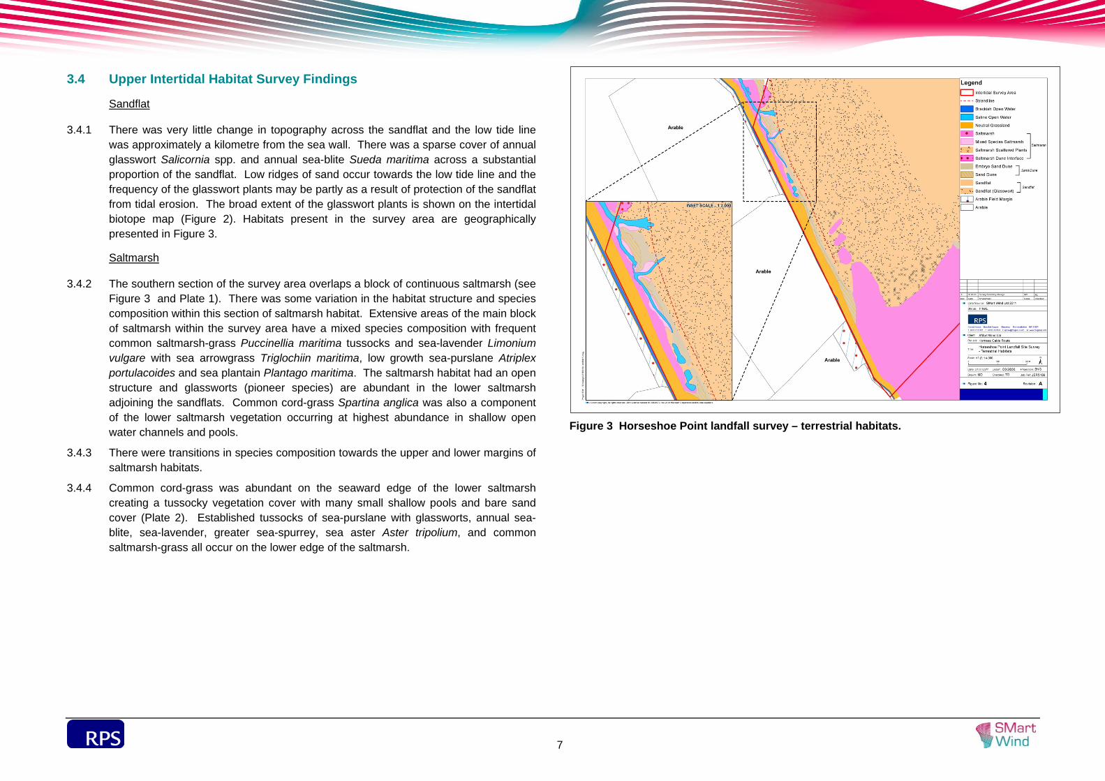
3.4.1 There was very little change in topography across the sandflat and the low tide line was approximately a kilometre from the sea wall. There was a sparse cover of annual glasswort Salicornia spp. and annual sea-blite Sueda maritima across a substantial proportion of the sandflat. Low ridges of sand occur towards the low tide line and the frequency of the glasswort plants may be partly as a result of protection of the sandflat from tidal erosion. The broad extent of the glasswort plants is shown on the intertidal biotope map (Figure 2). Habitats present in the survey area are geographically presented in Figure 3.
Saltmarsh
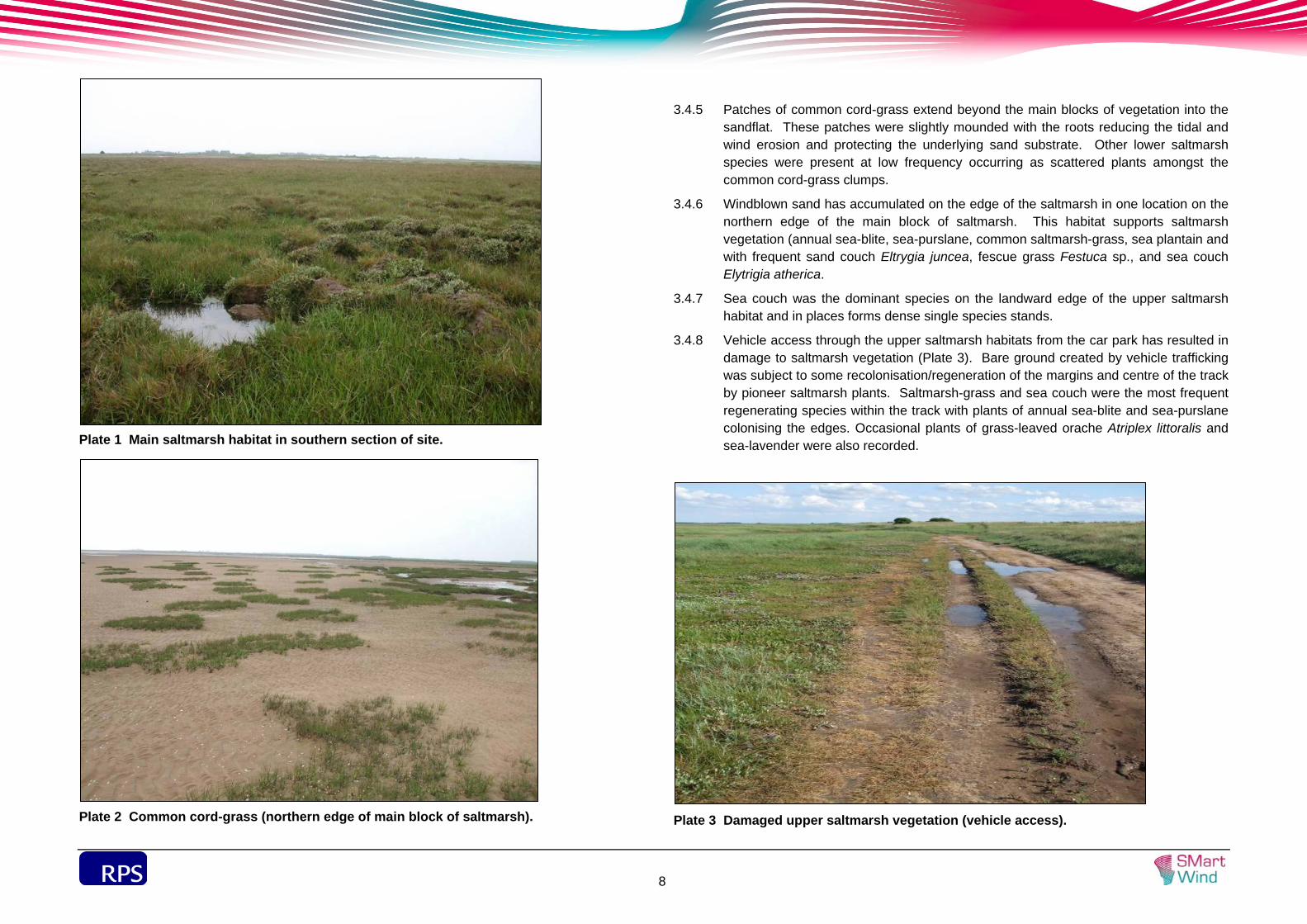
3.4.2 The southern section of the survey area overlaps a block of continuous saltmarsh (see Figure 3 and Plate 1). There was some variation in the habitat structure and species composition within this section of saltmarsh habitat. Extensive areas of the main block of saltmarsh within the survey area have a mixed species composition with frequent common saltmarsh-grass Puccinellia maritima tussocks and sea-lavender Limonium vulgare with sea arrowgrass Triglochiin maritima, low growth sea-purslane Atriplex portulacoides and sea plantain Plantago maritima. The saltmarsh habitat had an open structure and glassworts (pioneer species) are abundant in the lower saltmarsh adjoining the sandflats. Common cord-grass Spartina anglica was also a component of the lower saltmarsh vegetation occurring at highest abundance in shallow open water channels and pools.
3.4.3 There were transitions in species composition towards the upper and lower margins of saltmarsh habitats.
3.4.4 Common cord-grass was abundant on the seaward edge of the lower saltmarsh creating a tussocky vegetation cover with many small shallow pools and bare sand cover (Plate 2). Established tussocks of sea-purslane with glassworts, annual sea-blite, sea-lavender, greater sea-spurrey, sea aster Aster tripolium, and common saltmarsh-grass all occur on the lower edge of the saltmarsh.
Figure 3 Horseshoe Point landfall survey – terrestrial habitats.
sdf
8
Plate 1 Main saltmarsh habitat in southern section of site.
Plate 2 Common cord-grass (northern edge of main block of saltmarsh).
3.4.5 Patches of common cord-grass extend beyond the main blocks of vegetation into the sandflat. These patches were slightly mounded with the roots reducing the tidal and wind erosion and protecting the underlying sand substrate. Other lower saltmarsh species were present at low frequency occurring as scattered plants amongst the common cord-grass clumps.
3.4.6 Windblown sand has accumulated on the edge of the saltmarsh in one location on the northern edge of the main block of saltmarsh. This habitat supports saltmarsh vegetation (annual sea-blite, sea-purslane, common saltmarsh-grass, sea plantain and with frequent sand couch Eltrygia juncea, fescue grass Festuca sp., and sea couch Elytrigia atherica.
3.4.7 Sea couch was the dominant species on the landward edge of the upper saltmarsh habitat and in places forms dense single species stands.
3.4.8 Vehicle access through the upper saltmarsh habitats from the car park has resulted in damage to saltmarsh vegetation (Plate 3). Bare ground created by vehicle trafficking was subject to some recolonisation/regeneration of the margins and centre of the track by pioneer saltmarsh plants. Saltmarsh-grass and sea couch were the most frequent regenerating species within the track with plants of annual sea-blite and sea-purslane colonising the edges. Occasional plants of grass-leaved orache Atriplex littoralis and sea-lavender were also recorded.
Plate 3 Damaged upper saltmarsh vegetation (vehicle access).
sdf
9
3.4.9 Patches of common saltmarsh-grass have developed on the north-western side of the main saltmarsh with further small clumps of saltmarsh-grass extending into the sandflat on the seaward side. In addition to glasswort, annual sea-blite and greater sea-spurrey were locally frequent with sea-purslane, sea-lavender, sea aster and red fescue all occurring at lower frequency. There was a build up of sand beneath saltmarsh-grass with the patches likely to be expanding through vegetative spread and accumulations of sand.
Sand Dune
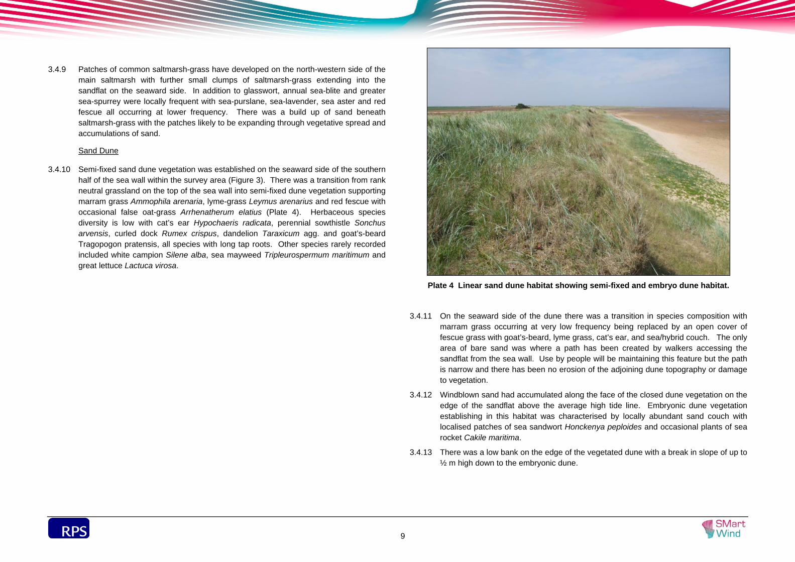
3.4.10 Semi-fixed sand dune vegetation was established on the seaward side of the southern half of the sea wall within the survey area (Figure 3). There was a transition from rank neutral grassland on the top of the sea wall into semi-fixed dune vegetation supporting marram grass Ammophila arenaria, lyme-grass Leymus arenarius and red fescue with occasional false oat-grass Arrhenatherum elatius (Plate 4). Herbaceous species diversity is low with cat’s ear Hypochaeris radicata, perennial sowthistle Sonchus arvensis, curled dock Rumex crispus, dandelion Taraxicum agg. and goat’s-beard Tragopogon pratensis, all species with long tap roots. Other species rarely recorded included white campion Silene alba, sea mayweed Tripleurospermum maritimum and great lettuce Lactuca virosa.
Plate 4 Linear sand dune habitat showing semi-fixed and embryo dune habitat.
3.4.11 On the seaward side of the dune there was a transition in species composition with marram grass occurring at very low frequency being replaced by an open cover of fescue grass with goat’s-beard, lyme grass, cat’s ear, and sea/hybrid couch. The only area of bare sand was where a path has been created by walkers accessing the sandflat from the sea wall. Use by people will be maintaining this feature but the path is narrow and there has been no erosion of the adjoining dune topography or damage to vegetation.
3.4.12 Windblown sand had accumulated along the face of the closed dune vegetation on the edge of the sandflat above the average high tide line. Embryonic dune vegetation establishing in this habitat was characterised by locally abundant sand couch with localised patches of sea sandwort Honckenya peploides and occasional plants of sea rocket Cakile maritima.
3.4.13 There was a low bank on the edge of the vegetated dune with a break in slope of up to ½ m high down to the embryonic dune.
sdf
10
Saltmarsh / Sand Dune mosaic
3.4.14 Linear saltmarsh and sand dune vegetation was present alongside the northern half of the section of sea wall included within the survey area (Figure 3). A channel of saline open water (see Section 4.1.20 below) was bounded by saltmarsh vegetation.
3.4.15 There was a defined transition of habitats between the sea wall and the open sandflat in this part of the survey area as described below:
Sea couch dominated grassland on the lower slope of the sea wall and adjoining parts of the channel of saline water;
More species-rich saltmarsh vegetation on the sides of the saline channel;
Sea couch dominated grassland on accumulated sand with false oat grass and lyme grass on the seaward side of the saline channel;
Open water connections between the main saline channel and the sandflat where there were gaps in the linear dune vegetation. These were bounded by a mixture of sand dune and saltmarsh vegetation plants; and
Accumulating windblown sand with embryo sand dune and saltmarsh species.
3.4.16 Dense stands of sea couch and hybrid sea couch covered much of the ground on both the landward and seaward side of the saline channel but distinct areas of more species-rich saltmarsh vegetation also occurs on the sides of the channel. Fat hen Chenopodium album is one of the few herbaceous species growing within the dense couch grass sward.
3.4.17 The mixed species saltmarsh varied between the edge of the sandflat and the dense sea couch grassland with a gradation from red fescue grassland to a saltmarsh-grass fringe on the lowest lying areas with longest periods of tidal inundation. Sea arrowgrass and saltmarsh rush Juncus gerardi were locally abundant between the two with sea-purslane, sea-lavender, English scurvygrass Cochlearia anglica, sea plantain, common scurvygrass Cochlearia officinalis, sea aster, sea-milkwort Glaux maritima and occasional sea thrift Armeria maritima and golden-samphire Inula crithmoides.
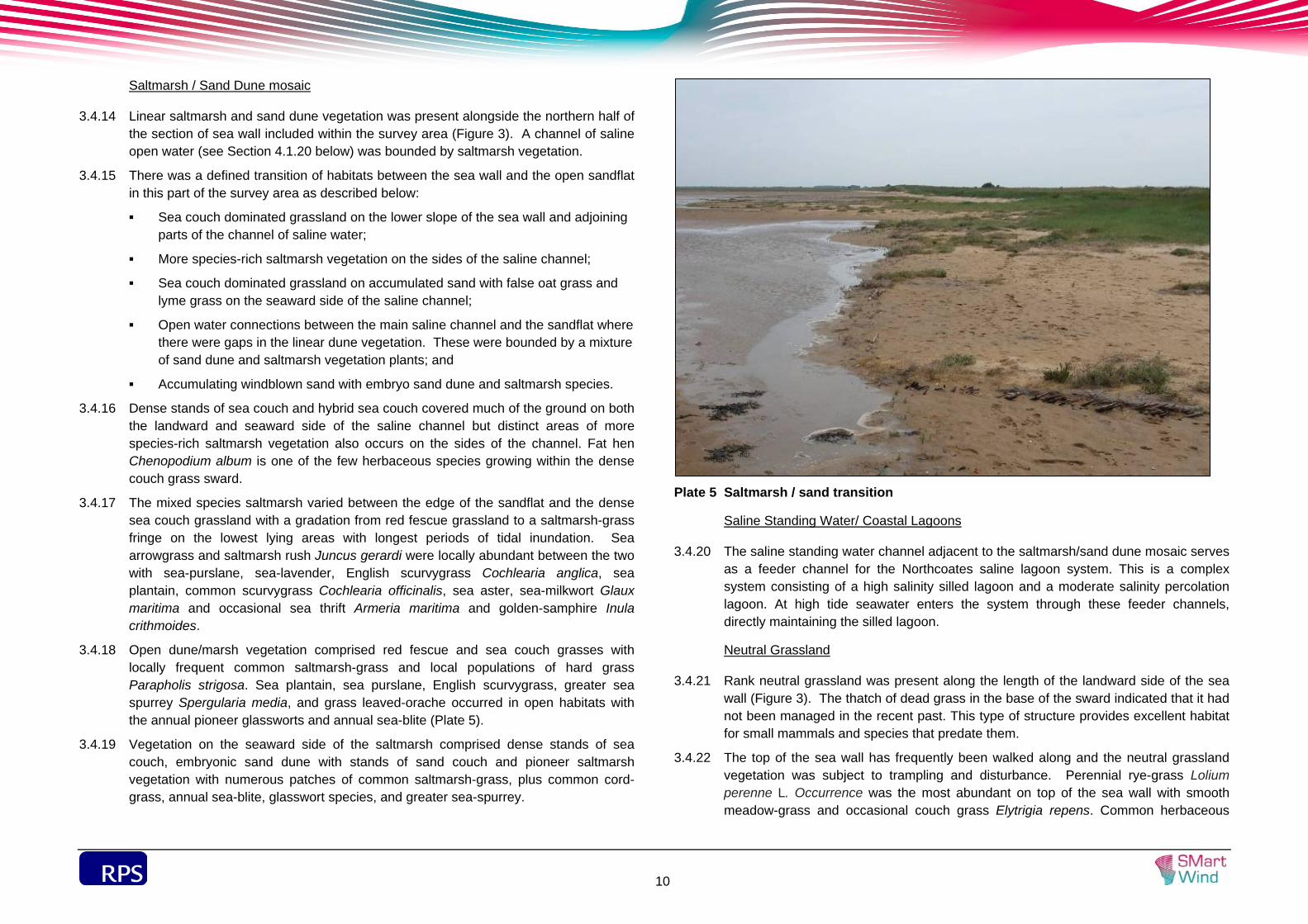
3.4.18 Open dune/marsh vegetation comprised red fescue and sea couch grasses with locally frequent common saltmarsh-grass and local populations of hard grass Parapholis strigosa. Sea plantain, sea purslane, English scurvygrass, greater sea spurrey Spergularia media, and grass leaved-orache occurred in open habitats with the annual pioneer glassworts and annual sea-blite (Plate 5).
3.4.19 Vegetation on the seaward side of the saltmarsh comprised dense stands of sea couch, embryonic sand dune with stands of sand couch and pioneer saltmarsh vegetation with numerous patches of common saltmarsh-grass, plus common cord-grass, annual sea-blite, glasswort species, and greater sea-spurrey.
Plate 5 Saltmarsh / sand transition
Saline Standing Water/ Coastal Lagoons
3.4.20 The saline standing water channel adjacent to the saltmarsh/sand dune mosaic serves as a feeder channel for the Northcoates saline lagoon system. This is a complex system consisting of a high salinity silled lagoon and a moderate salinity percolation lagoon. At high tide seawater enters the system through these feeder channels, directly maintaining the silled lagoon.
Neutral Grassland
3.4.21 Rank neutral grassland was present along the length of the landward side of the sea wall (Figure 3). The thatch of dead grass in the base of the sward indicated that it had not been managed in the recent past. This type of structure provides excellent habitat for small mammals and species that predate them.
3.4.22 The top of the sea wall has frequently been walked along and the neutral grassland vegetation was subject to trampling and disturbance. Perennial rye-grass Lolium perenne L. Occurrence was the most abundant on top of the sea wall with smooth meadow-grass and occasional couch grass Elytrigia repens. Common herbaceous
sdf
11
species were present at low abundance with white cover and ribwort plantain the most frequent.
3.4.23 Species composition was consistent across the habitat with abundant/dominant false oat-grass being the principal grassland component throughout. Red fescue Festuca rubra, smooth meadow grass Poa pratensis and creeping bent Agrostis stolonifera were also constant components but at low frequency along with the herbaceous species hogweed Heracleum sphondylium, tufted vetch Vicia cracca, upright hedge-parsley Torylis japonica, couch grass, common nettle Urtica dioica, goat’s-beard and fool’s parsley Aethusa cynapium.
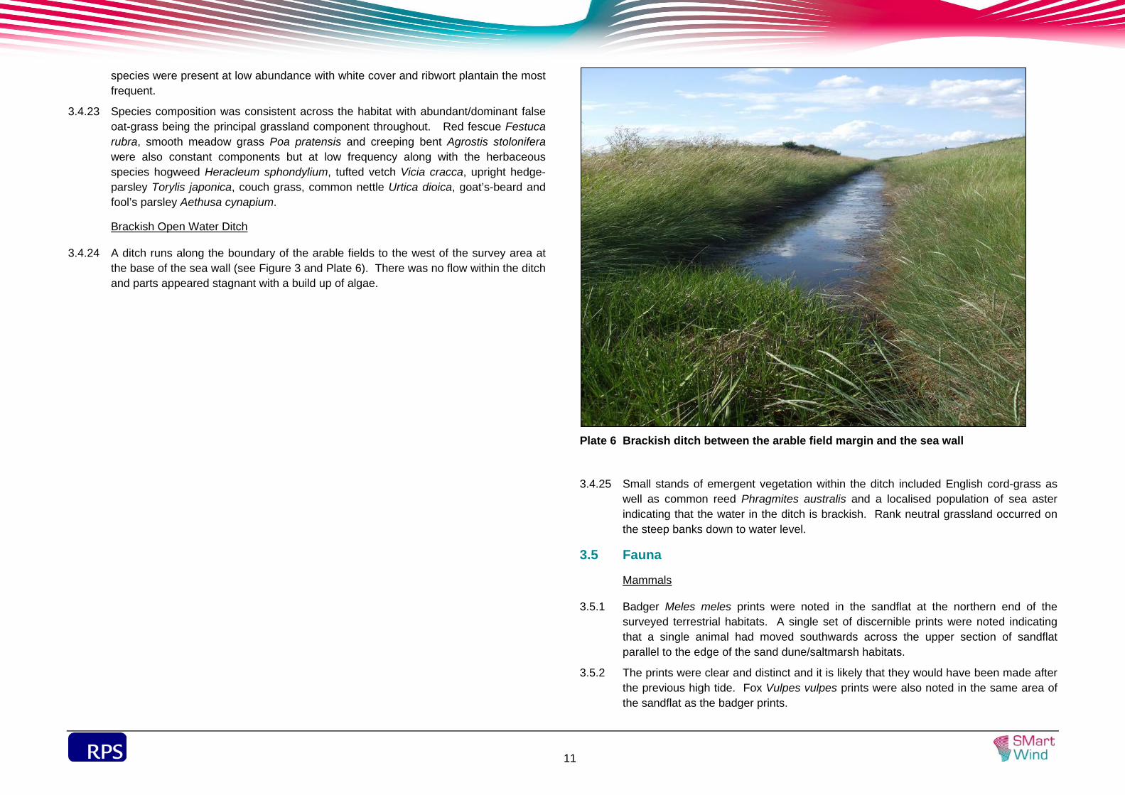
Brackish Open Water Ditch
3.4.24 A ditch runs along the boundary of the arable fields to the west of the survey area at the base of the sea wall (see Figure 3 and Plate 6). There was no flow within the ditch and parts appeared stagnant with a build up of algae.
Plate 6 Brackish ditch between the arable field margin and the sea wall
3.4.25 Small stands of emergent vegetation within the ditch included English cord-grass as well as common reed Phragmites australis and a localised population of sea aster indicating that the water in the ditch is brackish. Rank neutral grassland occurred on the steep banks down to water level.
3.5 Fauna
Mammals
3.5.1 Badger Meles meles prints were noted in the sandflat at the northern end of the surveyed terrestrial habitats. A single set of discernible prints were noted indicating that a single animal had moved southwards across the upper section of sandflat parallel to the edge of the sand dune/saltmarsh habitats.
3.5.2 The prints were clear and distinct and it is likely that they would have been made after the previous high tide. Fox Vulpes vulpes prints were also noted in the same area of the sandflat as the badger prints.
sdf
12
3.5.3 A juvenile stoat Mustela erminea was briefly observed on the top of the sea wall close to the northern edge of the survey area.
Birds
3.5.4 Limited territorial bird activity was noted during the walkover surveys. Redshank Tringa totanus gave repeated alarm calls on the north-western edge of the main block of saltmarsh indicating the presence of a nest or young.
3.5.5 Yellowhammer Emberiza citrinella and corn bunting Miliaria calandra were calling from cover on the sides of the sea wall and will have bred or held territory in the survey area. Both are species of high conservation concern having suffered significant declines in their breeding populations across the UK.
3.5.6 Barn owl Tyto alba was observed flying northwards into the survey area before dusk. The rank neutral grassland is a foraging habitat of high potential value for barn owl because of the abundance of small mammals that can be supporting beneath a dense thatch of dead grass.
3.5.7 Meadow pipit Anthus pratensis was recorded in drier grassland and saltmarsh habitat across the survey area and a pair of reed bunting Emberiza schoeniclus seen feeding on the main block of saltmarsh. Small numbers of wading birds were heard in and around the survey area during the walkover survey.
sdf
13
4 DISCUSSION
4.1 Habitats
Overview
4.1.1 The European Council Directive 92/43/EEC on the Conservation of Natural Habitats and Wild Fauna and Flora (The Habitats Directive), was adopted by the EU in response to the Berne Convention. It aims to protect all habitats listed within Annex I and all species within Annex II of the Directive. The survey area lies within the Humber Estuary SAC, which is designated primarily for the presence of the following Annex I habitats: estuary, mudflats and sandflats not covered by seawater at low tide, coastal lagoons, salicornia and other annuals colonising mud and sand, Atlantic salt meadows (Glauco-Puccinellietalia maritimae), and sand dunes (embryonic shifting dunes, shifting dunes with Ammophila arenaria (“white dunes”), fixed dunes with herbaceous vegetation ‘grey dunes’, and dunes with Hippophae rhamnoides).
4.1.2 Coastal saltmarsh is also listed in Annex 1 of the European Habitats Directive 1994 (as Atlantic Salt Meadows), indicative of their importance at a European scale. Coastal Saltmarsh is a UK BAP priority habitat and a habitat of principal importance in England. Local Authorities have special duties to further their conservation under Section 41 of the Natural Environment and Rural Communities Act 2004.
4.1.3 Sand dune habitats are also a UK BAP priority habitat and listed as a habitat of principal importance in England. Sand dunes consist of a variety of different habitat types. Fixed dune and dune heath are particularly threatened and are priorities under the EC Habitats Directive 1994. Semi-fixed dune and embryo dunes are also listed as Annex I habitats under the Habitats Directive (i.e. 2110 Embryonic shifting dunes and 2120 Shifting dunes along the shoreline with Ammophila arenaria (`white dunes`)).
4.1.4 The saltmarsh and sand dune habitats within the site are part of a complex of intertidal habitats. Although described separately below they should be viewed as inter-dependent parts of the same intertidal ecosystem.
4.1.5 The saline water channel within the saltmarsh/sand dune mosaic habitat represents a feeder channel for the Northcoates saline lagoon system. Coastal lagoons are listed as Annex I priority habitats under the EC Habitats Directive and the Northcoates saline lagoon system is one of the two lagoon systems within the Humber Estuary SAC (for which this habitat is a qualifying feature).
Intertidal
4.1.6 The intertidal zone in the survey area was dominated by predominantly sandy sediments. The upper shore was characterised by tube building polychaetes and amphipods and generally remained water-saturated throughout the low water tide. Within this upper shore community, scattered saltmarsh plants, specifically glasswort Salicornia sp. was also noted.
4.1.7 The upper to mid shore was characterised by a rippled surface, which also remained water-saturated during the low water tide. The species assemblage was dominated by the lugworm Arenicola marina and the thin tellin Angulus tenuis. An area of muddy-sand was also identified in the mid shore area, which was dominated by the cockles Cerastoderma edule. In contrast, the mid to lower shore was identified as an area of rippled intertidal sandbanks, which due to the low water retention support a limited range of species. The lower shore consists of clean rippled sand that remains damp throughout the tidal cycle and is characterised by a range of polychaetes including Lanice sp and Arenicola marina.
Saltmarsh
4.1.8 The saltmarsh plant communities are typical of the Lincolnshire coast with frequent common sea lavender and sea aster. The diversity of plant species is locally high with a range of specialist plants creating species-rich saltmarsh turf with localised populations of saltmarsh rush, sea arrowgrass, sea-milkwort, hard-grass and occasional plants of sea wormwood Seriphidium maritimum, grass-leaved orache and golden samphire. The transitional habitat of pioneer sand dune and saltmarsh vegetation also comprises a similar species assemblage. Small patches of saltmarsh vegetation have colonised the upper sections of sandflat.
4.1.9 The saltmarsh vegetation also appears to be extending into the sand flat from the main block of saltmarsh habitat to the south. There was a build up of sediment around the patches of saltmarsh-grass and common cord-grass occurring in the sandflat.
4.1.10 Glasswort plants extended across the entire upper section of sandflat in the survey area. The established and expanding saltmarsh habitats and pioneer vegetation directly contribute to the value of the SSSI and its national conservation status.
Sand Dune
4.1.11 The large expanse of sandflat which partially dries out at low tide creates the conditions that allow the accumulation of windblown sand and establishment of pioneer sand dune vegetation.
4.1.12 The extent of embryo dune within the survey area is likely to be typical of intertidal zones in Lincolnshire where the development of embryo dunes is more common than in other areas of the UK.
4.1.13 The semi-fixed sand dune vegetation was very limited in extent in the survey area. It has developed on sand trapped against the sea wall defence, but this results in an over-stablisation of the dune. There was an absence of mobile sand within the narrow strip of sand dune vegetation with abundant marram grass. In comparison a more natural system would have a much greater extent of mobile bare sand and a fixed dune grassland would have developed on the landward side of the marram grass, fed by windblown sand from the mobile dune phase.

sdf
14
4.1.14 The overstabilised dune is preventing the natural dynamism of a dune system and this is likely to have significantly limited the potential biodiversity value of the habitat within the site with fewer niches for specialist dune species to utilise.
Neutral Grassland
4.1.15 The neutral grassland comprises common grass and herbaceous species and was typical of a very common habitat which can be found across the local area. The value of the habitat for biodiversity will relate to the faunal species that are associated with it as discussed under the individual species groups.
4.1.16 The rank neutral grassland was dominated by a single coarse grass and does not directly contribute to the value of the SSSI and the habitat is likely to have value for nature conservation at no more than the local level.
Vascular Plants
4.1.17 The Humber Estuary as whole supports an important vascular plant assemblage, including at least ten nationally scarce species occurring in coastal and wetland habitats.
4.1.18 Grassland dominated couch grasses (primarily sea couch) was recorded in several areas. There is a coastal sub-species of common couch Elytrigia repens ssp. arenosa that has been included as a notable taxon in the SSSI citation. Common couch may have been under-recorded and this sub-species could be present in the survey area.
4.1.19 Sea buckthorn Hippophae rhamnoides was confirmed to be absent from the survey area but is known to be present in nearby saltmarsh/sand dune habitat to the north.
4.1.20 Much of the fescue grass vegetation was identified to species/sub-species level and it is possible that rush-leaved fescue Festuca arenaria, a nationally scarce plant, could be locally present amongst the more open sand dune vegetation and/or in sand dune/saltmarsh transitional habitat.
4.1.21 Nationally scarce saltmarsh and embryonic sand dune species recorded in the SSSI are bulbous foxtail Alopecurus bulbosus, bulbous meadow-grass Poa bulbosus, suffocated clover Trifolium suffocatum, curved hard-grass Parapholis incurva and spiral tasselweed Ruppia cirrhosa. None of these species were found during the walkover survey but their presence/absence could not be definitively confirmed during the walkover survey.
4.1.22 The other nationally scarce plant species in the SSSI; divided sedge Carex divisa, and slender hare’s-ear Bupleurum tenuissimum, and sea clover Trifolium squamosum typically occur in types of grassland that are not represented in the survey area.
Fauna
Mammals
4.1.23 There is likely to be a badger sett in the vicinity of the site and individuals will use the sandflats at low tide to find food. Badgers are omnivorous and will take a wide variety of prey species.
4.1.24 The only badger activity noted was close to the northern boundary and it is likely that the sett will be to the north of the survey area. There is extensive saltmarsh habitat in this area but the sett will need be located at a site that will always remain above the highest tides.
Birds
4.1.25 Bird surveys are currently being undertaken by RPS and will be issued separately to this report.
4.1.26 During the intertidal, sand dune and saltmarsh survey relatively little bird activity was noted but of the species recorded several have high conservation status, including yellowhammer and corn bunting, with their breeding populations across the UK suffering significant declines in their breeding populations. The saltmarsh, sand dune and neutral grassland will all be used by nesting birds or to help support the breeding bird assemblage in the site and its immediate surroundings.
Amphibians
4.1.27 The closest known natterjack toad Bufo calamita population lies over a kilometre from the survey area. The limited extent of sand dune and absence of any freshwater dune slack pools means that there is no good potential breeding habitat for this species. The open water associated with the saltmarsh will be inundated during each tidal cycle and are unsuitable for this species due to the salinity.
4.1.28 The closest off-site lagoon located in the saltmarsh to the north of the survey area was completely dry at the time of the survey in early July. If this dries up in summer each year it would not provide a breeding habitat that would sustain a natterjack toad population.
Invertebrates
4.1.29 Sand dunes and saltmarsh are also good habitat for invertebrates and support specialist species many of which have localised distributions and some have status as being nationally rare or scarce.
4.1.30 The saltmarsh and embryonic sand dune communities are locally botanically diverse and the potential exists for rare species to occur within the site.
sdf
15
4.1.31 Rarer species associated with more established sand dunes are less likely to be present due to the relative limited habitat extent and the absence of fixed dune grassland and slacks
4.1.32 Wall butterfly, a UK BAP priority species, has been recorded in several locations in the wider area in the past. This species is primarily found in coastal areas typically in grassland, wasteland, cliff edges and hedgerows. Some of this species’ primary larval foodplants were recorded in the neutral grassland (including bent grass species Agrostis spp., cock's-foot Dactylis glomerata, and Yorkshire-fog Holcus lanatus) but at low frequency. The neutral grassland on the sea wall has the potential to support this species.
sdf
16
5 CONCLUSION AND RECOMMENDATIONS
5.1.1 The habitats within the survey area directly contribute to the value and status of the Humber Estuary SAC and SSSI.
5.1.2 As a dynamic semi-natural ecosystem maintained by tidal inundation, it would be sensitive to change and damage. The intertidal mudflat and sandflat, saltmarsh and sand dune habitats are interdependent and any impact on one habitat could indirectly impact on parts of the wider ecosystem. For example, an adverse effect in one location would have the potential to result in a longer term impact through subsequent wind and/or tidal erosion.
5.1.3 Protection of saltmarsh and sand dune vegetation should be built into the design of any activity in the intertidal area of the SSSI. This would include embryonic dunes and areas where patches of saltmarsh-grass have colonised the sandflat habitat. An appropriate level of protection will help to safeguard the botanical and terrestrial invertebrate species assemblages in the survey area.
5.1.4 In order to protect the cockle bed noted on the mid shore, which has the potential to be of commercial value, works in this area should be avoided where possible.
5.1.5 Any activities on the sandflat should limit the impact on the glasswort plant community. The glasswort species and annual sea-blite are annual plants which reproduce by seed which is subsequently spread by wind and water. Therefore, the very localised loss of these plants on the sandflat should only result in a very short term effect of negligible significance.
5.1.6 Areas of activity including access routes to the sandflat should be located away from the locations of highest glasswort abundance (generally adjoining the main saltmarsh vegetation). An ecological clerk of works with experience of the marine environment should define permitted access routes and working areas to ensure that all potential measures are taken to minimise the magnitude and duration of localised impacts on the sandflat habitat.
sdf
17
6 REFERENCES
Connor, D. W., Allen, J. H., Golding, N., Howell, K. L., Lieberknecht, L. M., Nothern, K. O. and Reker, J. B. (2004). The Marine Habitat Classification for Britain and Ireland Version 04.05 Joint Nature Conservation Committee.
Davies, J., Baxter, J., Bradley, M., Connor, D., Khan, J., Murray, E., Sanderson, W., Turnbull, C. and Vincent, M. (2001). Marine Monitoring Handbook. UK Marine SACs Project, Joint Nature Conservation Committee.
Gregory, R. D., Wilkinson, N. I., Noble, D. G., Robinson, J. A., Brown, A. F., Hughes, J., Proctor, D. A., Gibbons, D. W. and Galbraith, C. A. (2002). The population status of birds in the United Kingdom, Channel Islands and the Isle of Man: an analysis of conversation concern 2002-2007. British Birds 95:410-450.
Institute of Environmental Assessment (1995). Guidelines for Baseline Ecological Assessment. Institute of Environmental Assessment.
Joint Nature Conservation Committee (2010). The Handbook for Phase 1 habitat survey. Joint Nature Conservation Committee.
Stace, C. (1997). New Flora of the British Isles 2nd Edition. Cambridge University Press.
BRIG Maddock, A.(ed.) (2008). UK Biodiversity Action Plan; Priority Habitat Descriptions. Wyn, G., Brazier, P., Birch, K., Bunker, A., Cooke, A., Jones, M., Lough, N., McMath, A. and Roberts, S. (2006). Handbook for Marine Intertidal Phase 1 Biotope Mapping Survey. Countryside Council for Wales.