MARDIE SALT/POTASH PROJECT (J05265) PRELIMINARY MINE ...
105
MARDIE SALT/POTASH PROJECT (J05265) PRELIMINARY MINE CLOSURE PLAN Ver. 1.3 EGS NAME: MARDIE CRYSTALLISATION PONDS / BCI EGS CODE: S0236066 TENEMENT(S): [M 08/525, M08/526, M 08/527, L08/184, L08/185] Pending COMPANY NAME: MARDIE MINERALS PTY LTD (ACN 152 574 457) a wholly owned subsidiary of BCI Minerals Limited (ACN 120 646 924) TENEMENT HOLDER(S): MARDIE MINERALS PTY LTD REGISTRATION ID: 85779 DATE: 17 November 2020 VERSION: 1 REVISION: 3 CONTACT: Neil Dixon Manager Approvals BCI Minerals Ltd 08 6311 3427 [email protected] This document has been prepared in accordance with “Statutory Guidelines for Mine Closure Plans in Western Australia ” (DMIRS, 2020).
Transcript of MARDIE SALT/POTASH PROJECT (J05265) PRELIMINARY MINE ...

MARDIE SALT/POTASH PROJECT (J05265)
PRELIMINARY MINE CLOSURE PLAN Ver. 1.3
EGS NAME: MARDIE CRYSTALLISATION PONDS / BCI
EGS CODE: S0236066
TENEMENT(S): [M 08/525, M08/526, M 08/527, L08/184, L08/185] Pending
COMPANY NAME: MARDIE MINERALS PTY LTD (ACN 152 574 457) a wholly owned subsidiary of BCI Minerals Limited (ACN 120 646 924)
TENEMENT HOLDER(S): MARDIE MINERALS PTY LTD
REGISTRATION ID: 85779
DATE: 17 November 2020
VERSION: 1
REVISION: 3
CONTACT: Neil Dixon Manager Approvals BCI Minerals Ltd 08 6311 3427 [email protected]
This document has been prepared in accordance with “Statutory Guidelines for Mine Closure Plans in Western Australia ” (DMIRS, 2020).


Mardie Minerals Pty Ltd
Mine Closure Plan: Mardie Project (2020)
Mine Closure Checklist and Corporate Endorsement
Q # Mine Closure Plan Checklist Y/ N/ NA
Page # Comments
1 Has the Checklist been endorsed by a senior representative within the tenement holder/operating company? (See bottom of checklist.)
Y Endorsed at the end of this checklist.
PUBLIC AVAILABILITY
2 Are you aware that from 2015 all MCPs will be made publicly available?
Y
3 Is there any information in this MCP that should not be publicly available?
N
4 If “Yes” to Q3, has confidential information been submitted in a separate document/ section?
NA
COVER PAGE, TABLE OF CONTENTS
5 Does the MCP cover page include: Project Title Company Name Contact Details (including telephone numbers and email addresses) Document ID and version number Date of submission (needs to match the date of this checklist)
Y
SCOPE AND PURPOSE
6 State why the MCP is submitted (e.g. as part of a Mining Proposal, a reviewed MCP or to fulfil other legal requirements)
NA Part of MP
PROJECT OVERVIEW
7 Does the project summary include: Land ownership details (include any land management agency responsible for the land / reserve and the purpose for which the land/ reserve [including surrounding land] is being managed) Location of the project; Comprehensive site plan(s); Background information on the history and status of the project.
Y Section 2
LEGAL OBLIGATIONS AND COMMITMENTS
8 Does the MCP include a consolidated summary or register of closure obligations and commitments?
Y Section 3
STAKEHOLDER ENGAGEMENT
9 Have all stakeholders involved in closure been identified? Y Section 4
10 Does the MCP include a summary or register of historic stakeholder engagement with details on who has been consulted and the outcomes?
Y Section 4

Mardie Minerals Pty Ltd
Mine Closure Plan: Mardie Project (2020)
Q # Mine Closure Plan Checklist Y/ N/ NA
Page # Comments
11 Does the MCP include a stakeholder consultation strategy to be implemented in the future?
Y Sect 4 Also Attachment 2
POST-MINING LAND USE(S) AND CLOSURE OBJECTIVES
12 Does the MCP include agreed post-mining land use(s), closure objectives and conceptual landform design diagram?
Y Sect 6
13 Does the MCP identify all potential (or pre-existing) environmental legacies, which may restrict the post mining land use (including contaminated sites)?
Y Sect 6.3
14 Has any soil or groundwater contamination that occurred, or is suspected to have occurred, during the operation of the mine, been reported to DER as required under the Contaminated Sites Act 2003?
NA
DEVELOPMENT OF COMPLETION CRITERIA
15 Does the MCP include an appropriate set of specific completion criteria and closure performance indicators?
Y Sect 8
COLLECTION AND ANALYSIS OF CLOSURE DATA
16 Does the MCP include baseline data (including pre-mining studies and environmental data)?
Y Sect 5
17 Has materials characterisation been carried out consistent with applicable standards and guidelines (e.g. GARD Guide)?
Y Sect 5.3 No ASS/ARD
18 Does the MCP identify applicable closure learnings from benchmarking against other comparable mine sites?
Y Sect 5.8
19 Does the MCP identify all key issues impacting mine closure objectives and outcomes (including potential contamination impacts)?
Y Sect 7.4
20 Does the MCP include information relevant to mine closure for each domain or feature?
Y Sect 9
IDENTIFICATION AND MANAGEMENT OF CLOSURE ISSUES
21 Does the MCP include a gap analysis/risk assessment to determine if further information is required in relation to closure of each domain or feature?
Y Sect 7 & 9.2
22 Does the MCP include the process, methodology, and has the rationale been provided to justify identification and management of the issues?
Y Sect 7
CLOSURE IMPLEMENTATION
23 Does the MCP include a summary of closure implementation strategies and activities for the proposed operations or for the whole site?
Y Sect 9.6

Mardie Minerals Pty Ltd
Mine Closure Plan: Mardie Project (2020)
Q # Mine Closure Plan Checklist Y/ N/ NA
Page # Comments
24 Does the MCP include a closure work program for each domain or feature?
Y Sect 9.2 & 9.6
25 Does the MCP contain site layout plans to clearly show each type of disturbance as defined in Schedule 1 of the MRF Regulations?
Y Figure 20
26 Does the MCP contain a schedule of research and trial activities?
N Preliminary Plan – closure 60 years time
27 Does the MCP contain a schedule of progressive rehabilitation activities?
N Preliminary Plan – closure 60 years time
28 Does the MCP include details of how unexpected closure and care and maintenance will be handled?
Y
29 Does the MCP contain a schedule of decommissioning activities?
N Preliminary Plan – closure 60 years time
30 Does the MCP contain a schedule of closure performance monitoring and maintenance activities?
N Preliminary Plan – closure 60 years time
CLOSURE MONITORING AND MAINTENANCE
31 Does the MCP contain a framework, including methodology, quality control and remedial strategy for closure performance monitoring including post-closure monitoring and maintenance?
NA Preliminary Plan – closure 60 years time
FINANCIAL PROVISIONING FOR CLOSURE
32 Does the MCP include costing methodology, assumptions and financial provision to resource closure implementation and monitoring?
Y Section 11
33 Does the MCP include a process for regular review of the financial provision?
Y As part of Corporate fiscal systems
MANAGEMENT OF INFORMATION AND DATA
34 Does the MCP contain a description of management strategies including systems and processes for the retention of mine records?
Y Sect 12
I hereby certify that to the best of my knowledge, the information within this Mine Closure Plan and checklist is true and correct and addresses all the requirements of the Guidelines for the Preparation of a Mine Closure Plan approved by the Director General of the Department of Mines and Petroleum.
Name: Michael Klvac
Position: BCI Manager Corporate Affairs
Signed: _______________________________ Date:

Mardie Minerals Pty Ltd
Mine Closure Plan: Mardie Project (2020)
Page i
Table of Contents
1 SCOPE AND PURPOSE ......................................................................................................................................... 6
1.1 SCOPE .................................................................................................................................................................. 6
2 PROJECT SUMMARY ........................................................................................................................................... 8
2.1 PROJECT LOCATION ................................................................................................................................................ 8 2.2 PROJECT DESCRIPTION ............................................................................................................................................ 8
2.2.1 Processing and production ............................................................................................................................ 8 2.2.2 Site access and product export ..................................................................................................................... 8 2.2.3 Project domains and Mining Activities .......................................................................................................... 8
2.3 LAND TENURE...................................................................................................................................................... 10 2.4 APPROVALS AND AGREEMENTS ............................................................................................................................... 12
3 IDENTIFICATION OF CLOSURE OBLIGATIONS AND COMMITMENTS .................................................................. 13
3.1 LEGAL OBLIGATIONS ............................................................................................................................................. 13 3.2 APPROVAL DOCUMENTS ........................................................................................................................................ 13
3.2.1 Mining Proposal .......................................................................................................................................... 13 3.2.2 Mardie Project Trial Pond ........................................................................................................................... 14 3.2.3 Works Approval ........................................................................................................................................... 14 3.2.4 EPBC Act ...................................................................................................................................................... 14 3.2.5 Rights in Water and Irrigation Act .............................................................................................................. 14 3.2.6 Gas pipeline crossing ................................................................................................................................... 14
3.3 MCP PLANNING GUIDELINES ................................................................................................................................. 14
4 STAKEHOLDER ENGAGEMENT .......................................................................................................................... 16
4.1 INTRODUCTION .................................................................................................................................................... 16 4.2 CONSULTATION STRATEGY ...................................................................................................................................... 16
4.2.1 Key stakeholders ......................................................................................................................................... 16 4.2.2 Consultation and Engagement Program ..................................................................................................... 17 4.2.3 Summary of stakeholder feedback and outcomes ...................................................................................... 17 4.2.4 Effectiveness ............................................................................................................................................... 17
5 BASELINE AND CLOSURE DATA AND ANALYSIS ................................................................................................. 19
5.1 CLIMATE ............................................................................................................................................................. 19 5.2 LANDSCAPE AND TOPOGRAPHY ............................................................................................................................... 19
5.2.1 Topography ................................................................................................................................................. 19 5.3 GEOLOGY AND SOILS ............................................................................................................................................. 20
5.3.1 Soils ............................................................................................................................................................. 20 5.4 GEOTECHNICAL INFORMATION ................................................................................................................................ 21
5.4.1 Study scope and effort ................................................................................................................................ 21 5.4.2 Geotechnical units ....................................................................................................................................... 21 5.4.3 Soil permeability ......................................................................................................................................... 24
5.5 HYDROLOGY ........................................................................................................................................................ 25 5.5.1 Introduction ................................................................................................................................................ 25 5.5.2 Tidal cycle .................................................................................................................................................... 25 5.5.3 Intertidal zone flow regimes ....................................................................................................................... 26 5.5.4 Influence of cyclones and tropical lows ....................................................................................................... 29 5.5.5 Storm surges ............................................................................................................................................... 29 5.5.6 Tidal creeks ................................................................................................................................................. 29 5.5.7 Surface water .............................................................................................................................................. 30 5.5.8 Groundwater ............................................................................................................................................... 33
5.6 BIODIVERSITY ...................................................................................................................................................... 35 5.6.1 Survey effort ................................................................................................................................................ 35 5.6.2 Flora ............................................................................................................................................................ 38

Mardie Minerals Pty Ltd
Mine Closure Plan: Mardie Project (2020)
Page ii
5.6.3 Vegetation .................................................................................................................................................. 38 5.6.4 Benthic communities and habitats ............................................................................................................. 43 5.6.5 Terrestrial fauna habitats ........................................................................................................................... 48 5.6.6 Terrestrial fauna ......................................................................................................................................... 48 5.6.7 Marine fauna .............................................................................................................................................. 53
5.7 SOCIAL VALUES .................................................................................................................................................... 55 5.7.1 Aboriginal Heritage ..................................................................................................................................... 55 5.7.2 European Heritage ...................................................................................................................................... 55 5.7.3 Recreation and amenity .............................................................................................................................. 56
5.8 OTHER CLOSURE RELATED DATA .............................................................................................................................. 60 5.8.1 Mardie Salt Trial Pond and Ancillary Works................................................................................................ 60 5.8.2 Study: Shorebird Foraging Ecology in Northwestern Australian Saltworks ................................................ 60 5.8.3 Study: South Bay Salt Pond Restoration Project ......................................................................................... 61
6 POST-MINING LAND USE .................................................................................................................................. 62
6.1 CONSIDERATIONS ................................................................................................................................................. 62 6.2 SELECTION APPROACH .......................................................................................................................................... 62 6.3 CONSIDERATIONS OF OFFSETS ................................................................................................................................ 62 6.4 POST MINING LAND USE ....................................................................................................................................... 63
7 CLOSURE RISK ASSESSMENT ............................................................................................................................. 64
7.1 OVERVIEW .......................................................................................................................................................... 64 7.2 METHODOLOGY ................................................................................................................................................... 64
7.2.1 Scope ........................................................................................................................................................... 64 7.2.2 Risk Assessment Criteria ............................................................................................................................. 64
7.3 RISK ANALYSIS ..................................................................................................................................................... 66 7.4 IDENTIFICATION OF CLOSURE ISSUES ......................................................................................................................... 71
7.4.1 Breaching Pond Walls ................................................................................................................................. 71 7.4.2 Brine Seepage ............................................................................................................................................. 71 7.4.3 Established Ecosystems ............................................................................................................................... 71 7.4.4 Landform Stability ....................................................................................................................................... 71 7.4.5 Catchment flows ......................................................................................................................................... 71 7.4.6 Re-vegetation and Habitat Recreation ....................................................................................................... 72 7.4.7 Weed Infestations ....................................................................................................................................... 72 7.4.8 Residual Hydrocarbons ............................................................................................................................... 72
8 CLOSURE OUTCOMES AND COMPLETION CRITERIA .......................................................................................... 73
8.1 IDENTIFYING ASPECTS AND DEFINING OUTCOMES ....................................................................................................... 73 8.2 ESTABLISHING REFERENCE ...................................................................................................................................... 73 8.3 ATTRIBUTE IDENTIFICATION .................................................................................................................................... 74 8.4 COMPLETION CRITERIA .......................................................................................................................................... 74
9 CLOSURE IMPLEMENTATION ............................................................................................................................ 77
9.1 LAND DISTURBANCE ............................................................................................................................................. 77 9.2 CLOSURE WORKS PROGRAM ................................................................................................................................... 81 9.3 RESEARCH, INVESTIGATIONS AND TRIALS ................................................................................................................... 83 9.4 PROGRESSIVE REHABILITATION ................................................................................................................................ 83
9.4.1 Inactive areas .............................................................................................................................................. 83 9.4.2 Contaminated sites ..................................................................................................................................... 83
9.5 UN-PLANNED CLOSURE .......................................................................................................................................... 84 9.6 DECOMMISSIONING .............................................................................................................................................. 84
9.6.1 Condenser ponds ......................................................................................................................................... 84 9.6.2 Seawater intake .......................................................................................................................................... 85 9.6.3 Crystalliser ponds ........................................................................................................................................ 85 9.6.4 Process infrastructure ................................................................................................................................. 86 9.6.5 Borrow pits and surface excavations .......................................................................................................... 86

Mardie Minerals Pty Ltd
Mine Closure Plan: Mardie Project (2020)
Page iii
9.6.6 Transport corridors ..................................................................................................................................... 86 9.6.7 Drainage channels and stormwater diversion ............................................................................................ 86 9.6.8 Ancillary infrastructure ............................................................................................................................... 87 9.6.9 Site buildings and amenities ....................................................................................................................... 87 9.6.10 Power generation ................................................................................................................................... 87 9.6.11 Laydown hardstand ................................................................................................................................ 88 9.6.12 Village accommodation .......................................................................................................................... 88 9.6.13 Workshops and service facilities ............................................................................................................. 88 9.6.14 Landfill .................................................................................................................................................... 89
10 CLOSURE MONITORING AND MAINTENANCE ................................................................................................... 90
11 FINANCIAL PROVISIONING FOR CLOSURE ......................................................................................................... 91
12 MANAGEMENT AND REVIEW OF DATA ............................................................................................................ 92
12.1 INFORMATION REQUIREMENTS AND USE .................................................................................................................. 92 12.2 DATA MANAGEMENT PROCESSES ............................................................................................................................ 92
13 REFERENCES ..................................................................................................................................................... 93
ATTACHMENTS ......................................................................................................................................................... 95
List of Tables
Table 1: Lands affected by the proposal ......................................................................................................... 10 Table 2: Legislation Relevant to Mardie Minerals Mine Closure Plan ............................................................. 13 Table 3: Stakeholders consulted during the mining development process. ................................................... 16 Table 4: Summary of the Stakleholder Engagement and Communicatons for the Mardie Project – Mine Closure Plan. .................................................................................................................................................... 18 Table 5: Published geological units of the Project area .................................................................................. 20 Table 6: Summary of Permeability Testing ...................................................................................................... 25 Table 7: Estimate flood flows (m3/s) ............................................................................................................... 32 Table 8: Vegetation associations within the Mardie Project disturbance envelope (Phoenix, 2019a) .......... 39 Table 9: Benthic community habitats associated with the Mardie Project (from O2 Marine, 2019) ............. 43 Table 10: Terrestrial fauna habitat types and their proportion of the study area .......................................... 48 Table 11: Summary of desktop and field terrestrial fauna species recorded ................................................. 49 Table 12: Migratory bird species recorded within the MSSA .......................................................................... 50 Table 13: Key marine fauna of conservation significance potentially present in the tidal creeks at Mardie . 53 Table 14: Registered Sites and Other Heritage Places .................................................................................... 57 Table 15: Risk criteria matrix: Likelihood of impact occurring ........................................................................ 64 Table 16: Risk criteria matrix: Consequence of impact occurring ................................................................... 65 Table 17: Risk criteria matrix: Risk levels......................................................................................................... 66 Table 18: Mine Closure; Mardie Project Environmental and Heritage Risk Assessment ................................ 67 Table 19: Aspects and Outcomes Identified for the Mardie Project ............................................................... 73 Table 20: Completion criteria and monitoring/timeframes associated with identified MCP outcomes. ....... 75 Table 21: Mining Activities for each mining domain as per MRF Categories described in schedule 1 of the MRF Regulations 2013 ............................................................................................................................................. 79 Table 22; Closure works program identifying management gaps, research, premature closure tasks and monitoring required for each domain. ............................................................................................................ 81
List of Figures
Figure 1: Regional location of the Mardie Project .............................................................................................. v

Mardie Minerals Pty Ltd
Mine Closure Plan: Mardie Project (2020)
Page iv
Figure 2: Map of Mardie Project process overview .......................................................................................... 9 Figure 3: Map of current land tenure influencing the Mardie Project. ........................................................... 11 Figure 4: Mardie climate data (average monthly temperature and rainfall records) ..................................... 19 Figure 5: Locations of geotech study sites ...................................................................................................... 22 Figure 6: Measured water level data from inshore Aquadopp location November 2018 .............................. 26 Figure 7: Example of a Mardie tidal creek and intertidal areas, with views inland towards the east ............ 26 Figure 8: Tidal inundation-frequency graph for Mardie (2.75 mLAT = 0.00 mAHD) ....................................... 27 Figure 9: Modelled inundation on low tide and high spring tides (RPS, 2019a) ............................................. 28 Figure 10: Mardie Creek – tidal creek located adjacent to the Proposal ........................................................ 30 Figure 11: Surface water catchments (RPS, 2019b) ........................................................................................ 31 Figure 12: Photo of Mardie Pool, a permanent water body ........................................................................... 33 Figure 13: Schematic hydrogeological cross-section across the development envelopes (east/west) (from Soilwater Consultants, 2019b) ........................................................................................................................ 34 Figure 14: Boundaries of different Study Areas .............................................................................................. 36 Figure 15: Locations of conservation significant flora (Phoenix, 2019a) ........................................................ 37 Figure 16: Site vegetation types (from Phoenix, 2019a) ................................................................................. 40 Figure 17: West Pilbara Mesquite Infestation Map – Prepared for DPIRD by PMMC September 2019 ......... 42 Figure 18: BCH distribution across the survey areas ....................................................................................... 47 Figure 19: Migratory bird records ................................................................................................................... 52 Figure 20: Native Title areas and Registered Heritage Sites ........................................................................... 59 Figure 21: Mining Activities for Key Mining Activites and Other Mining Activites as per MRF Categories described in schedule 1 of the MRF Regulations 2013 ................................................................................... 78

Mardie Minerals Pty Ltd
Mine Closure Plan: Mardie Project (2020)
Page v
Figure 1: Regional location of the Mardie Project

Mardie Minerals Pty Ltd
Mine Closure Plan: Mardie Project (2020)
Page 6
1 SCOPE AND PURPOSE
The Mardie Minerals Preliminary Mine Closure Plan (MCP) has been prepared by Mardie Minerals Pty Ltd (Mardie Minerals), a wholly-owned subsidiary of BCI Minerals Ltd, for the purposes of developing the Mardie Salt/Potash Project (J05265), located on the coast between Karratha and Onslow (Figure 1)
1.1 Scope
The MCP applies to those components of the Mardie Project that are located within Mining Lease Applications: M08/525, M08/526, M08/527 and M08/528
This MCP is submitted as part of the requirements of Section 84AA of the Mining Act 1978 (Mining Act). This version of the MCP has been developed to support the Mardie Mineral’s Salt and Potash Mining Proposal and has been prepared in accordance with the Guidelines for the Preparation of a Mine Closure Plan (DMIRS, 2020) and submitted in the format proposed under the Statutory Guidelines for Mine Closure Plans in Western Australia (DMIRS, 2020). In accordance with these guidelines, the MCP has been established to ensure the Mardie Project will meet the following principal closure objectives.
• all disturbed areas should be rehabilitated such that they are rendered physically safe to humans and animals, geotechnically stable, geo-chemically non-polluting/non-contaminating and capable of sustaining an agreed post-mining land use (DMIRS); and
• premises are decommissioned and rehabilitated in an ecologically sustainable manner (EPA).
The purpose of the MCP is to provide a strategic plan that will facilitate closure activities throughout the life of the Mardie Project. The approach that has been taken includes:
• Identifying those aspects related to decommissioning and closure which may impact on environment and health and safety outcomes and which may be of concern to stakeholders;
• Providing a basis for consultation with identified stakeholders (including regulators) regarding post-mining land use and developing agreed completion criteria;
• Outline objective criteria for measuring closure performance;
• Developing strategies based on site knowledge and industry experience and research which will be implemented during the life of the Project (from the feasibility stage through to post-closure) to minimise impacts and closure requirements;
• Evaluating financial provisions, as accurately as possible, to assess the liabilities associated with closure; and
• Outlining processes required for closure rehabilitation monitoring, the maintenance of data and the ability to report showing progress towards closure criteria.
The MCP describes the long-term elements of the mine planning cycle and the relationship to shorter term, responsive operational needs, as well as dealing with project and environmental uncertainties. The MCP follows an approach of structured adaptive management, from a strong information and performance baseline, with an emphasis on continual improvement.
This MCP is limited to the works included in the mining proposal and therefore works outside of the plan have been excluded. Such works include; bitterns disposal pipelines and outfall, trestle jetty export facility and transhipment channel.
At an early stage of mine closure planning the key mine closure activities are likely to include:
• Decommission of the concentrator ponds including removing excessive hypersaline material, breaching external walls to restore water movement across the landscape and stabilising closure landforms.
• Remove hypersaline material from crystalliser ponds, cover and rehabilitate.

Mardie Minerals Pty Ltd
Mine Closure Plan: Mardie Project (2020)
Page 7
• Reinstating landscape drainage.
• Recover any hypersaline groundwater plumes, where present and likely to Mardie Pool.
• Removal of all processing, conveying/stockpiling and miscellaneous infrastructure.
• Investigate and remediate sources of contamination.
• Rehabilitate roads, transport corridors and all other miscellaneous open areas not required by other parties.
• Remove safety hazards.

Mardie Minerals Pty Ltd
Mine Closure Plan: Mardie Project (2020)
Page 8
2 PROJECT SUMMARY
2.1 Project Location
The Proposal is located in the western Pilbara region of WA, approximately 80 km south west of Karratha (Figure 1).
2.2 Project Description
The proposed Mardie Salt/Potash Project (Mardie Project or the Project) will include solar concentration ponds, crystallisation ponds and processing plants, capable of producing up to 4 million tonnes per annum (tpa) of industrial-grade salt (NaCl) and up to 100,000 tpa of sulphate of potash (SOP), all being derived from seawater.
2.2.1 Processing and production
A process overview diagram for the concentration of seawater and production of salt and SOP has been included in Figure 2. The process starts with water being abstracted from the ocean via a screened seawater intake. Through natural evaporation, the seawater is condensed into a brine within a series of nine concentrator ponds. The brine from the final concentrator pond is pumped into the primary crystalliser ponds, where halite (NaCl) salts are harvested. Remaining brine is decanted and sent to the secondary crystalliser ponds, where further halite salts are recovered.
Following harvesting, halite salts from both crystallisation ponds are transported to the salt wash plant, where impurities (mainly gypsum and dust) are washed out of the salt. The secondary crystalliser ponds also produce kainite type mixed salt (KTMS) crystals, which is harvested, stockpiled and then processed through the SOP plant. Remaining brines, including washwater from the salt wash plant, is ultimately sent to a bitterns dilution pond prior to being diluted with seawater and discharged out to sea through a multi-port diffuser, located along the export jetty, outside of the mining tenements.
2.2.2 Site access and product export
Vehicular access to the project area is via Mardie Road, which connects to the North West Coastal Highway, approximately 22 km distant. The highway provides road access to Karratha in the north, and Onslow to the south (Figure 1).
Salts and SOP from the project will be exported seaward using a purpose-built offshore export facility, consisting of a 3.5 km long trestle jetty, a shiploader berthing area and a 4 km long dredge channel. These will be designed and constructed to specifications stipulated by the Pilbara Ports Authority (PPA), which will hold tenure over the export facility.
2.2.3 Project domains and Mining Activities
The Mardie Project has been divided up into closure domains which consist of feature that share similar decommissioning and closure requirements/objectives. These closure domains include:
1. Concentrator Ponds 2. Crystalliser Ponds 3. Process Infrastructure 4. Borrow Pits and Surface Excavations 5. Transport Corridors 6. Drainage Channels and Stormwater Diversion 7. Ancillary Infrastructure

Mardie Minerals Pty Ltd
Mine Closure Plan: Mardie Project (2020)
Page 9
Figure 2: Map of Mardie Project process overview

Mardie Minerals Pty Ltd
Mine Closure Plan: Mardie Project (2020)
Page 10
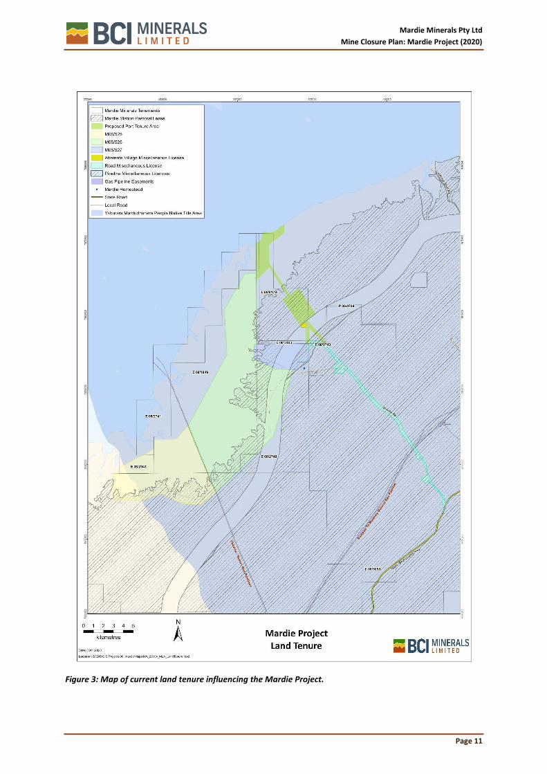
2.3 Land Tenure
The lands that fall within the project area, as defined by the four lease areas, are listed in Table 1 and shown in Error! Reference source not found.. The two dominant tenure types are Unallocated Crown Land (UCL), which is managed by LandGate, and the Mardie Pastoral Lease, which is held by Pastural Management Pty Ltd (PMPL). The four lease areas do not intersect any petroleum or geothermal titles or assets. All underlying Mining Act tenure is held by Mardie Minerals.
Table 1: Lands affected by the proposal
Land ID Purpose/Name 08/525 08/526 08/527 L08/184 L08/185
UCL Unallocated Crown Land (UCL) 3624.9178 7021.9718 125.2381 46.2 0.5
PL N050076 Pastoral Lease (C) Mardie 1186.2658 2489.9448 621.6231 19.1
Water (UCL) Unallocated Crown Land (UCL) 0.7735
R 9701 “C” Class Reserve (De Grey Mullawa Stock Route)
1036.3066 443.0665
R 379 “C” Class Reserve (Watering Place for Travellers and Stock)
39.4317
Closed Road Road Reserves Closed 8.8116
FNA 14693 File Notation Area: Proposed Section 91 LAA Licence
FNA 14731 File Notation Area: Onshore Port Investigation Area
0.3936 16.3979 46.2 19.6
Mardie Minerals Pty Ltd
Mine Closure Plan: Mardie Project (2020)
Page 11
Figure 3: Map of current land tenure influencing the Mardie Project.

Mardie Minerals Pty Ltd
Mine Closure Plan: Mardie Project (2020)
Page 12
2.4 Approvals and Agreements
The Mardie Project is currently undergoing environmental impact assessment under Part IV of the (WA) Environmental Protection Act 1986 (EP Act) and the (Cth) Environment Protection and Biodiversity Conservation Act 1999 (EPBC Act). At a suitable juncture, Mardie Minerals will then apply for several secondary approvals, such as a Works Approval under Part V of the EP Act.
With regards to Aboriginal Heritage and Native Title agreements and permits, Mardie Minerals has secured land access agreements with Yaburara Mardudhunera (YM) People and Kuruma Mardudhunera (KM) People (see section 5.7). In addition to legislative requirements, Mardie Minerals has a land access agreement with PMPL, the leaseholder and commercial operator of Mardie Station.

Mardie Minerals Pty Ltd
Mine Closure Plan: Mardie Project (2020)
Page 13
3 IDENTIFICATION OF CLOSURE OBLIGATIONS AND COMMITMENTS
3.1 Legal Obligations
Mardie Minerals recognises its legal responsibilities as described in statutory documentation, including general provisions of the following legislation and regulation relevant to closure of the project. Further to the existing legislative requirements for mine closure in Western Australia (WA) created under the Mining Act; and Environmental Protection Act 1986 (EP Act), the requirements of a number of additional statutes and regulations also create legal obligations and/or considerations of relevance to the rehabilitation and closure of the Mardie project are listed in Table 2. Table 2: Legislation Relevant to Mardie Minerals Mine Closure Plan
Type Title
Environmental Legislation Environmental Protection Act 1986.
Environmental Protection Regulations 1987.
Environmental Protection (Clearing of Native Vegetation) Regulations 2004.
Environmental Protection (Controlled Waste) Regulations 2004.
Contaminated Sites Act 2003.
Biodiversity Conservation Act 2016
Soil and Land Conservation Act 1945
Environment Protection and Biodiversity Conservation Act 1999 (Commonwealth).
Mining and Safety Legislation
Dangerous Goods Safety Act 2004.
Mining Act 1978.
Mining Regulations 1981.
Mines Safety and Inspection Act 1994.
Mines Safety and Inspection Regulations 1995.
Occupational Safety and Health Act 1984.
Mining Rehabilitation Fund Act 2012.
Mining Rehabilitation Fund Regulations 2013.
Health Act 1911
Indigenous Legislation Aboriginal Heritage Act 1972.
Aboriginal Heritage Regulations 1974.
Native Title Act 1993 (Commonwealth).
Land/Pastoral Legislation Land Administration Act 1997.
Conservation and Land Management Act 1984.
Biosecurity and Agricultural Management Act 2007.
Land Administration (Land Management) Regulations 2006.
Land Administration Regulations 1998.
Water Legislation Rights In Water and Irrigation Act 1914.
These statutes form part of a legal obligations register for the MCP (Attachment 1). that will be maintained for the operational life of the salt field, including a live legal obligation register and closure works program register for closure requirements. The updated and current legal obligations register will be included in the future revisions of this MCP.
3.2 Approval Documents
3.2.1 Mining Proposal
The Mardie Project Mining Proposal will enable Mardie Minerals to develop the Mardie Project, which was referred to the (WA) Environmental Protection Authority (EPA) in April, 2018 and is currently undergoing environmental impact assessment under the processes set out in Part IV of the EP Act).

Mardie Minerals Pty Ltd
Mine Closure Plan: Mardie Project (2020)
Page 14
3.2.2 Mardie Project Trial Pond
Minor activities such as such as evaporative salt trial ponds have been conducted under Section 41(A) of the EP Act which enables proponents to carry out minor or preliminary work associated with the proposal with the consent of the EPA. In addition, Mardie Minerals have received EPA consent to conduct a large scale trial works (as per PoW Reg ID 81611) to test geotechnical and engineering requirements to build the evaporative pond system.
3.2.3 Works Approval
The Mardie Project will require a number of works approvals in order to operate. Works Approvals for the following categories will be sort:
• Category 14: Solar Salt Manufacturing
• Category 64: Class II Landfill
• Category 85: Sewerage Facility
• Category 52: Power Generation >10MW
Currently a salt production pilot study (Category 14) is in progress at the site and operating under Works Approval W6172/2018/1.
3.2.4 EPBC Act
The Project was referred to the Department of the Environment and Energy (DotEE) on 15 June 2018 (EPBC 2018/8236). The DotEE determined that the Proposal was a ‘controlled action’ and required assessment and approval under the Environment Protection and Biodiversity Conservation Act 1999 (Cth) (EPBC Act), due to the potential impacts on the following relevant controlling provisions:
• Listed threatened species and communities (sections 18 & 18A); • Listed migratory species (sections 20 & 20A); and • Commonwealth marine areas (sections 23 & 24A).
DotEE provided comment and input into the content of the (ESD).
The Project will be assessed as an ‘accredited assessment’ under Part IV of the EP Act. Section 87 of the EPBC Act makes provisions for the EPA to undertake this accredited assessment of the potential impacts to Matters of National Environmental Significance (MNES) on behalf of DotEE.
3.2.5 Rights in Water and Irrigation Act
Mardie Minerals has been advised by the Department of Water and Environment Regulation (DWER) that a permit to disturb the banks of the seawater intake tidal creek, or for the abstraction of seawater, is not required under the Rights in Water and Irrigation Act 1914.
3.2.6 Gas pipeline crossing
Accessing the works site will require crossing of the SANTOS and Chevron Varanus Island to DBNGP Onshore gas pipeline. Mardie Minerals is currently negotiating access agreements with SANTOS and Chevron regarding the interaction of the Mardie Project with the gas pipeline and associated licences and easements. Mardie Minerals has also applied for two Mining Act miscellaneous licences to secure authority to cross the gas pipelines with a road, brine pipelines (carrying brine from pond 2 to pond 3) and water management infrastructure. Mardie Minerals has designed the gas pipeline crossings to ensure that the integrity of the gas pipelines is maintained and risks to the pipeline are reduced.
Mardie Minerals expect that the access agreements will be executed in Q2 2020 and miscellaneous licences granted within the same quarter.
3.3 MCP Planning Guidelines
The primary policy framework relevant to this document is the DMP and EPA (2019) guidelines for preparing mine closure plans. The DMP and the then Office of the Environmental Protection Authority (OEPA) jointly prepared these guidelines for mine closure planning. The following government policy

Mardie Minerals Pty Ltd
Mine Closure Plan: Mardie Project (2020)
Page 15
documents and industry standards were also considered in developing the preliminary closure planning framework for the Mardie project:
• Guidelines for Mining Proposals in Western Australia (DMP 2020); • Strategic Framework for Mine Closure (ANZMEC 2000); • A Framework for Developing Completion Criteria (WABSI 2019) • Mine Rehabilitation (DOITR 2006a); and • Mine Closure and Completion (DOITR 2006b).
Mardie Minerals Pty Ltd
Mine Closure Plan: Mardie Project (2020)
Page 16
4 STAKEHOLDER ENGAGEMENT
4.1 Introduction
This section describes the stakeholder consultation and engagement process that has been undertaken to assist in all phases of the project, from development through closure. The opportunity to provide input and feedback about the Mardie Project has been made to a range of individuals and organisations, including all three levels of government, industry, landholder, and community stakeholders, and the opportunity continues to be available.
4.2 Consultation strategy
Mardie Minerals has a Consultation Strategy with the principle objective of the early identification of issues and opportunities for consideration in the Project’s closure planning. The strategy involves the following processes:
1. Identification of key external stakeholders and their potential relationship to the Project; 2. develop and implement a consultation and engagement program, appropriate to the phase
of the Project and relevant stakeholders; 3. record and, if suitable, respond to stakeholder inputs and feedback; and 4. monitor the effectiveness of the strategy.
4.2.1 Key stakeholders
A list of key stakeholders was developed early in the Project development process and is continually reviewed and expanded during the implementation of the consultation and engagement program. The range of stakeholders that have been provided with the opportunity to participate in the process is shown in Table 3.
Table 3: Stakeholders consulted during the mining development process.
Category Stakeholder
Cth. Government Department of the Environment and Energy (DotEE)
Department of Industry Innovation and Science (DIIS)
Minister for Resources and Northern Australia.
WA Government DWER (EPA Services, Industry Regulation, Water)
Department of Jobs, Tourism, Science and Innovation (DJTSI)
Department of Mining, Industry Regulation and Safety (DMIRS)
Department of Biodiversity, Conservation and Attractions (DBCA)
Department of Transport (DoT)
Department of Planning, Lands and Heritage (DPLH)
Department of Primary Industries and Regional Development (DPIRD)
Minister of Mines and Petroleum; Commerce and Industrial Relations; Electoral Affairs; Asian Engagement
Minister for Regional Development and Ports
Minister for State Development
Minister for the Environment and Water
Vince Catania - WA National Member for North West
Main Roads WA
Pilbara Ports Authority
WA Marine Science Institute (WAMSI)
Local Government City of Karratha
Pilbara Development Commission
Traditional Owner Yaburara Mardudunera People (YM People)
Kuruma Marthudunera People (KM People)

Mardie Minerals Pty Ltd
Mine Closure Plan: Mardie Project (2020)
Page 17
Category Stakeholder
Industry CITIC Pacific Mining
SANTOS Ltd
Chevron Australia
WA Fishing Industries Council
Leichhardt Industrial Minerals Pty Ltd
Landholder Pastoral Management Pty Ltd (Pastoral lease holder for Mardie Station)
Community Groups Pilbara Mesquite Management Committee (PMMC)
Conservation Council WA
Australian Nature Conservation Agency / Australian Wildlife Conservancy
Birds Australia / Birdlife Australia
Greening Australia
Pilbara Corridors
Rangelands Natural Resource Management WA
Wildflower Society
King Bay Sporting Fishing Club
Nickol Bay Sporting Fishing Club
Hampton Harbour Boat and Sailing Club
4.2.2 Consultation and Engagement Program
The Mardie Consultation and Engagement Program has been designed to reflect current and future Project phases, where opportunities to act on feedback remain open. Communication tools, pathways and methods all aim to maximise opportunities for feedback from stakeholders. These include:
• Face-to-face meetings;
• telephone conversations;
• information packs, with invitations to provide comment or request additional information;
• presentations and other inputs to stakeholder forums; and
• newspaper and journal articles.
4.2.3 Summary of stakeholder feedback and outcomes
All relevant feedback is captured, collated and analysed by the Project team. Where appropriate, key issues have been considered in the process of studying, designing and assessing preferred project options. Key issues raised are listed below, with all relevant feedback summarised in stakeholder communications register Table 4. The complete Mardie Consultation Register for the entire project has been included in Attachment 3.
• Direct and indirect impacts to mangrove, algal mat and tidal samphire communities, including maintenance of sea and stormwater movement;
• potential impacts to migratory shorebirds;
• potential impacts to groundwater availability and quality;
• management of weeds (Mesquite);
• impacts to Mardie Pool (Wirawundi Pool) and other heritage places;
• long-term employment and contracting opportunities for the regional communities, including Traditional Owner groups; and
• increased stability of City of Karratha as a result of increased permanent population within the region.
4.2.4 Effectiveness
Mardie Minerals tracks the effectiveness of its consultation strategy to ensure the stakeholder register is sufficiently comprehensive and representative of the total target audience, and that, where

Mardie Minerals Pty Ltd
Mine Closure Plan: Mardie Project (2020)
Page 18
feedback has been received from a stakeholder, that the stakeholder is reasonably satisfied with the processes and response.
Table 4: Summary of the Stakleholder Engagement and Communicatons for the Mardie Project – Mine Closure Plan.
Stakeholder Engagement Register for the Mardie Project Mine Closure Plan
Date Stakeholder Contact Outcome
21/01/2020 DMIRS Meeting Overview of the current Mardie mining tenement applications and the supporting MP & MCP, including how the two documents relate to the Environmental Review Document (ERD) that is currently being finalised through the EPA
2020 - Ongoing Mardie Station Meeting; Emails; Letters
Ongoing meetings to discuss and correpsondance to discuss project status and timing. Items include; approvals to date, future applications, studies undertaken and key findings, indigenous contracting and employment opportunities.
11/02/2020 DMIRS MCP lodgement
BCI (Neil Dixon) lodged the MARDIE SALT-POTASH PROJECT (J05265) INITIAL MINING PROPOSAL, V1.1
30/4/2020 DMIRS Letter REQUESTED FURTHER INFORMATION REGARDING MINING PROPOSAL AND MINE CLOSURE PLAN – MARDIE MINERALS LIMITED – M08/525, M08/526, M08/527, L08/184 AND L08/185 – MARDIE SALT-POTASH / BCI – J05265 - REGISTRATION ID 85779
15/5/2020 PMMC Phone Discussion regarding extent of Mesquite within the western pilbara. Jo Williams (Project Manager) provided additional information including map of Mesquite infestation.
4/05/2020 DMIRS Phone DMIRS RFI Discussion - ID85779

Mardie Minerals Pty Ltd
Mine Closure Plan: Mardie Project (2020)
Page 19
5 BASELINE AND CLOSURE DATA AND ANALYSIS
5.1 Climate
The Pilbara bioregion has an arid to tropical climate with average maximum temperatures over 40°C from November to February and an average maximum of 25°C during the winter months (Leighton, 2004; McKenzie et al., 2009). Annual rainfall across the broader Pilbara region averages approximately 290 mm and is most prevalent over the summer months in association with cyclonic activity to the north and northwest, though annual rainfall is highly variable (McKenzie et al., 2009).
A BoM weather station is located at Mardie Homestead (Site number 005008), immediately east of the Proposal. Mardie records its highest maximum mean monthly temperature (37.9°C) in January and lowest (25.3°C) in February, with its highest minimum mean (27.7°C) and lowest (11.8°C) in July. Average annual rainfall is 278.7, with highest monthly average rainfall recorded in February (62.7 mm) and March (49.0 mm) (BoM 2018) (Figure 4).
Figure 4: Mardie climate data (average monthly temperature and rainfall records)
5.2 Landscape and topography
The Mardie Project is located approximately 80 km south west of Karratha, between the towns of Onslow and Dampier on the Pilbara coast, in the north-west of WA (Figure 1). The main mining feature, being evaporation ponds, will be constructed on mud flats on the landward side of the coastal mangroves, approximately 2 km below the mapped shoreline.
5.2.1 Topography
The Project area is typically low in the landscape, ranging between 1.5 m and 2.0 mAHD with minimal gradients (down to 0.02%). Localised areas of higher elevation (to approximately 10 mAHD) exist across the sand mounds that are present within the Project area.
Mardie Minerals has generated a detailed Digital Elevation Model (DEM) of the project area and surrounds, using several different sources, including several digital orthophotography fly-overs. Datasets were combined and ground-truthed to ensure the reliability of environmental and engineering studies utilising the DEM.

Mardie Minerals Pty Ltd
Mine Closure Plan: Mardie Project (2020)
Page 20
5.3 Geology and soils
Generally speaking, the majority of the Project area is characterised by coastal silt and evaporite material of estuarine, lagoonal and lacustrine deposits (Qe lithology), with gypsum dominating. Further away from the coastline, the area is dominated by channel and flood plain alluvium (locally calcreted) of gravel, sand, silt and clay (Qa lithology); and clay-silt-sand with sheet and nodular kankar (Qrc lithology).
Published information
The 1:250,000 published geological series maps titled ‘Yarraloola’ (Sheet SF 50-6, 1968) provides an indication of the geological units of the project area (Table 5)
Table 5: Published geological units of the Project area
Geological Unit Summary Description
Alluvium Flats Unconsolidated fluviatile sediments; beach sand; silt on high tide flats.
Flood Deposits Unconsolidated fluviatile and sheet deposits on levees and river terraces.
Aeolian Sand Fixed, well vegetated coastal dunes and sand.
Eluvium and alluvium Residual ‘high level’ clay and sandy clay plain; residual deposits of sand,, gravel and pebbles.
Geological model
CMW (2019) developed a geological model for the project, based on surface topography, landform, CPT, testpit and borehole records, and published geologyThe model outputs can be summarised as “ inter and supratidal flats located east of a littoral fringe and west of an area of alluvial outwash”. CMW defines the terms used, as follows:
• intertidal flats are covered during ordinary tidal events, albeit at Mardi the main flats are covered only on spring or equinox tidal highwater events;
• supratidal flats, which lie further to the east, are covered only during exceptional events such a highest astronomical tide, storm surges, cyclones and during times of high inland flow discharge coinciding with high tides; and
• the alluvial outwash zone is dominated by gravel, gravelly clay and sandy clay, likely represent the different energy levels of sheet-wash and channelized flood events that laid down these deposits.
Towards the western edge of the intertidal flats some relatively thin soft to firm clays are present and these thicken as noted in CPTs further west in the littoral fringe. Some organics are noted in these materials. In addition, along the western edge of the intertidal/supratidal flats cemented strata (calcareous sandstone and calcarenite) are noted in boreholes at elevations between -3 and -5 mAHD.
5.3.1 Soils
SWG conducted laboratory analysis on samples collected from the top 0.5 m of the various soil profiles of the project area (SWG, 2019c). The soil types described by SWG that are applicable to the trial are clays and clay loams. These two soil types exhibited similar physical and chemical properties, namely:
• both had a fine texture, being dominated by silt and clay, and had very low hydraulic conductivities;
• both were moderately alkaline and highly – extremely saline;
• both were highly sodic and exhibited high cation exchange capacity.
The different soils were difficult to distinguish in the field, and no organic crust or topsoil layer was evident.

Mardie Minerals Pty Ltd
Mine Closure Plan: Mardie Project (2020)
Page 21
Acid Sulphate Soils
SWG completed a Desktop Acid Sulphate Soils (ASS) Assessment for the Mardie project area (SWG, 2019b). This desktop assessment reviewed the following documents / information:
• DWER-053 Acid Sulfate Soil Risk Map, Pilbara Coastline;
• Stantec (2017) Stage A: Acid Sulfate Soils Investigation – Mardie Salt Project;
• SWC (2019) Mardie Salt and SOP Project – Soils Assessment and Seepage Modelling; and
• Results and field logs from recent Geotechnical Survey (CWM, 2019).
Although the DWER-053 ASS Risk Map shows that the majority of the Mardie Project is classified as having a High to Moderate Risk of ASS, shallow ASS sampling and testing to a depth of 1 m by Stantec (2017) showed that none of the soils were considered ASS, with pHF and pHFOX test results were all circum-neutral to highly alkaline, with negligible difference in pH (i.e. < 1 pH unit). Stantec (2017) attributed this to the prevalence of gypsum across the intertidal area.
The more recent work completed by SWG (2019b) showed that the supratidal flats were formed by alluvial and fluvial deposition from the various river systems traversing the Mardie Project area, with these sediments deposited onto a pre-existing calcarenite surface. The nature of the surface soils sampled by Stantec (2017) is therefore representative of the alluvial and fluvial sediments throughout the supratidal flats, and thus it is expected that gypsum is dominant throughout the profile, with low to negligible risk of ASS occurring. In addition, the hypersaline nature of the sediment prevents vegetation growth and therefore there is insufficient organic material to host or support ASS in this environment (SWG, 2019b).
5.4 Geotechnical information
5.4.1 Study scope and effort
CMW Geosciences Pty Ltd (CMW) was commissioned over the 2018 – 2019 period to conduct a geotechnical study program of increasing detail over the project area, for the purposes of providing factual information on the soil, rock and groundwater conditions encountered and providing detailed level geotechnical models of embankment alignments and process infrastructure. The program commenced with desktop reviews of previous studies of the project site and concluded with several fieldwork campaigns, involving 142 CPT and 6 DCP tests, 121 test pits, 54 borehole tests, the installation of 81 piezometers, deep diamond cores, dissipation testing, falling head tests, and the collection of samples for follow-up laboratory test work (Figure 5). All fieldwork was carried out under the supervision of Engineering Geologists and Geotechnical Engineers from CMW Geosciences Pty Ltd and in general accordance with AS1726 (2017), Geotechnical Site Investigations.
5.4.2 Geotechnical units
The ground conditions encountered by CMW were categorised into six separate units, as detailed below. It is important to note that Units 2, 3, 4 and 6 have been split into sub-units typically based on differing strengths. Similarly, the formation of the lower units (Units 5 and 6) is a function of variable cementation, as described above. Because of this, the units presented below are not necessarily sequential and are not necessarily present at all borehole locations.
UNIT 1 – Surficial Outwash
This unit is generally found east of the 2 m contour and comprises a thin (200-300 mm) surficial deposit of loose clayey sandy gravel that represents deposition of material during high flow rainfall and outwash events (with particles dropping out based on the energy of the inflow).
In the north around the northern crystallizer pond this material is represented by low lying gravelly islands which are indicative of the previously significant amounts of fines and sand being washed away during high tides and / or overland flow resulting in a higher proportion of gravel material.

Mardie Minerals Pty Ltd
Mine Closure Plan: Mardie Project (2020)
Page 22
Figure 5: Locations of geotech study sites

Mardie Minerals Pty Ltd
Mine Closure Plan: Mardie Project (2020)
Page 23
UNIT 2 – Aeolian/Beach Sand/Calcarenite
Unit 2 comprises of aeolian dune sand and beach sand deposits. In some locations these have been cemented to form calcarenite. These deposits are found across the site in elevated areas, generally within the islands encountered across the site and along the eastern fringe of the proposed ponds. This unit generally extends to the depth of the dunes and was encountered to a depth in excess of 3 m within the north eastern section of the concentrator ponds.
Classification testing indicates Unit 2 comprises between 80% to 99% sand and gravels with fines contents of between 1% and 20% by weight. The calcium carbonate content results ranged from 60.9% to 83.9%.
This unit has been separated into Unit 2a and Unit 2b. The upper part of the unit (2a) likely represents a coastal foredune depositional environment, deposited mostly by aeolian processes with the lower part of the unit (2b) likely represents a shallow marine/beach depositional environmental.
Unit 2a generally comprises of sand that also contains some cemented gravel sized particles in some areas. Unit 2b generally comprises sand and gravels composed of shells. The sands are typically medium dense to dense. Both units have cemented layers in some locations forming rock strength materials like calcarenite.
UNIT 3 – Clay/Sandy Clay
This upper unit is variable in nature and typically denotes the layers of the intertidal and supratidal flats west of the elevated dune sand deposits, as described above. It typically comprises medium to high plasticity dark brown clays. This unit is typically very soft to soft at the surface (0.0m to 1.5m) and becomes firm to very stiff at depth. Locally it has variability in secondary and minor constituents, becoming classified as “with sand” to “sandy” and “trace gravel or gravelly” in some locations. Generally, the unit is 1 – 3 m in thickness but is up to approximately 4.5 m in some places.
The classification testing indicated that Unit 3 predominantly comprises clays and sandy clay. Median fines content was 61% (ranging between 16% and 89%), median sand content was 27% (ranging between 10% and 70%) and median gravel content was 4.5% (ranging between 0% and 67%). Atterberg limits displayed a variability in behaviour for Unit 3 from non-plastic silts to liquid limits as high as 70%. Following exclusion of the non-plastic silts the median liquid limit for Unit 3 was 43% (ranging between 7% and 70%) and the median plasticity index was 25% (ranging between 4% and 45%). These Atterberg Limits generally indicate medium to high plasticity clays.
This unit has been separated on the cross sections into Unit 3A where it has been encountered as very soft to soft and Unit 3B for material with an inferred consistency of firm or stiffer. Typically, Unit 3A has been encountered towards the western side of the site, generally below areas with a ground elevation of approximately 2m AHD. This unit is generally thickest in the west and thins out towards the east and is typically not present where ground levels are above 2m AHD. Unit 3b is generally present across the entire site, either underlying the softer Unit 3a or directly below the overlying units where Unit 3a is absent (i.e. generally above ground levels of 2m AHD).
The SPT values of Unit 3a are generally less than 10 (as low as 0) with an average of approximately 3.7, indicating an average undrained shear strength of less than 15 kPa. The SPT values of Unit 3b are generally between 20 and 35 with an average of approximately 30, indicating an average undrained shear strength approximately 100 kPa to 125 kPa.
UNIT 4 – Clayey Gravel/Gravelly Clay
Beneath Unit 3 a very stiff/hard/very dense unit of gravelly clay/clayey gravel was encountered. This unit has been interpreted from the CPT probes as causing refusal. SPTs undertaken within this unit also frequently met with refusal, although they did range from 20 to 50 generally within the top 4 m depth.
This unit also contains cemented layers/zones that were encountered at different elevations and locations across the site. These layers are typically a calcareous conglomerate with a variable
Mardie Minerals Pty Ltd
Mine Closure Plan: Mardie Project (2020)
Page 24
cementation and strength typically from hard clay to medium strength rock (Unit 5, below). They also comprise some discrete lenses of calcareous claystone.
Unit 4 was encountered over a variable depth and thickness, generally ranging from approximately 4 m to 8 m thick, but increasing to almost 15 m in some locations. The base of the unit was also variable, being found as shallow as 2 mAHD and as deep as -5 mAHD.
The laboratory test results indicate that Unit 4 generally comprises a mixture of clayey gravels and gravelly clays with a fines content varying from approximately 7% to 87%, an average across the range of 32%. Gravel content varied from approximately 1% to 81% with an average of 45%. The Atterberg Limits also indicate a variety of behaviours with materials being low to high plasticity with one sample below the A-line (clay and silt behaviour exhibited).
Rock sections (Unit 5 below) within Unit 4 are generally variable in strength with poorly defined trends in strength vs depth/elevation.
UNITS 5 & 6 – Impure Calcilutite/ Calcareous Conglomerate/Clay
This material was typically encountered as a pale yellow and grey mottled red and brown. The upper layers (Unit 5) typically exhibit variable cementation, strength and composition with lenses, seams and bands of Unit 4 material plus hard clay/sandy clay to very low to medium strength rock. As discussed above, the variability in Unit 5 was often observed around the circumference of the core and it was not practical to provide a single material type. Therefore, in many instances the strata encountered was given both a rock and soil description. The rock zones of this unit mostly comprise calcareous conglomerate but was also logged as impure calcilutute and calcareous claystone. In the lower strata (Unit 6), the cementation and strength increased to generally a low to high strength (locally very high) rock. Within this unit there was less variability around the circumference of the core and limited seams and bands of soil noted. The indicators between the two units have been taken as Unit 5 comprising a variable description from soil to rock, whereas Unit 6 comprises of predominantly rock material of higher quality and strength. Unit 6 typically comprises of impure calcilutite but was also logged as impure calcisiltite, impure calcirudite and calcilutite.
The Atterberg Limits undertaken on the soil section of Unit 5 indicate medium high plasticity clay, with fines contents of between approximately 30% to 70%. The calcium carbonate testing undertaken on samples within Unit 5 and 6 indicates a minimum value of 58%, a maximum value of 72% and an average value of 67%. This indicates that this material is calcareous. SPT tests undertaken in this unit typically met with refusal and only three SPTs undertaken had less than >50 blows (26, 31 and 33). These SPTs were undertaken within stiff soil lenses of Unit 4 within these units.
The rock sections of these units are generally variable in strength with poorly defined trends in UCS strength vs depth/elevation. However, strength does appear to increase with depth, generally being very low to low strength to a depth of approximately 12m, however, some areas of medium and high strength are present. Beneath this depth a general increase to above medium strength, with some areas up to very high strength being observed. The point load index test results show a no trend in strength with depth and an approximate correlation of PLI to UCS of approximately 16 is appropriate with strengths approximately medium to high.
Unit 6 has been separated into 6A and 6B based on the degree of cementation and associated strength. Where rock has been encountered consistently as high to very high strength, with cementation in places of a crystalline nature, the material has been designated Unit 6B on the cross sections.
5.4.3 Soil permeability
Soil permeability is a key driver in the funding and design process for this project. The base of the ponds requires low permeability material to be present in order to minimise loss of product from seepage through the base of the pond. Similarly, the material used for embankment fill also requires low permeability in order to reduce seepage of product through embankments.
Permeability testing has been completed for this project comprising the following:

Mardie Minerals Pty Ltd
Mine Closure Plan: Mardie Project (2020)
Page 25
• Dissipation testing during CPTu probes;
• Falling head permeability testing;
• Double Ring Infiltrometer testing;
• Laboratory triaxial testing during the consolidation phase;
• Laboratory consolidation testing;
• Laboratory constant head permeability testing.
The results of the permeability tests are presented in
Table 6: Summary of Permeability Testing
Permeability Testing Type
Unit
Permeability (m/sec)
Minimum Maximum Average
Dissipation 3 1.2 x 10⁻¹⁰ 7.5 x 10⁻⁸ 6.2 x 10⁻⁹
Lab Permeability Tests
3 7.5 x 10⁻¹¹ 5.9 x 10⁻⁹ 8.5 x 10⁻¹⁰
4 5.1 x 10⁻⁹ 1.4 x 10⁻⁷ 7.1 x 10⁻⁸
Falling Head Tests 4 8.1 x 10⁻⁷ 9.4 x 10⁻⁶ 3.8 x 10⁻⁶
5.5 Hydrology
5.5.1 Introduction
The Mardie Project sits at the interface of two different hydrological influences: marine (tidal and storm pulses) and ephemeral catchment flows. The intertidal mudflats and saltflats in which the majority of the project is situated can be viewed as a very large, continuous basin, with regular marine and episodic freshwater inputs, which either discharge to the ocean or evaporate, with only minor infiltration to groundwater.
The hydrology of the project area, in terms of water levels, water chemistry and frequency of inundation, is recognised as being fundamental to the maintenance of the significant ecological values and processes of the area, including the provision of habitat resources for migratory seabirds and protected near-shore marine fauna.
5.5.2 Tidal cycle
The Mardie Project experiences a semi-diurnal tide (two highs and two lows a day) and the tidal planes have been defined by the National Tide Centre (NTC) based on field measurements completed for the Proposal in late 2018 (Baird, 2019a). The Mardi Gauge (MardiLAT18) datum definition completed by the NTC shows that the offset between Lowest Astronomical Tide (LAT) and Mean Sea Level (MSL) is 2.75 m and the total tidal range is 5.185 m. The mean tide range is 3.6 m in springs and 1 m in neaps.
Mardie Minerals commissioned a network of metocean monitoring stations off the Mardie coast to collect data on currents and tides, as well as water quality information. The metocean data has been used to calibrate a hydrodynamic model of the coastal processes to aid in project design and environmental impact assessment (Baird, 2019a). Measured data from an inshore Aquadopp in November 2018 is shown in Figure 6, illustrating the water level time series through the spring and neap cycles. It is noted that the instrument could not measure tide levels below -2m MSL, owing to its location.

Mardie Minerals Pty Ltd
Mine Closure Plan: Mardie Project (2020)
Page 26
Figure 6: Measured water level data from inshore Aquadopp location November 2018
Baird (2019) produce an inundation-frequency graph (Figure 8), based on tide levels over the period October 2019 – March 2020 and shows the proportion of time (x-axis) that the tide will be higher than a certain elevation (y-axis). For the evaporation ponds, where the typical ground elevation is 2.0 mAHD, the graph indicates that the site will be affected by tides approximately 5% of the time. The lower-lying work areas (1.7 mAHD) will be inundated approximately 12% of the time.
5.5.3 Intertidal zone flow regimes
Seawater floods the intertidal areas through the mangrove zone or out of the tidal creeks via multiple low points that occur along the full length of the creeks (Figure 7). This occurs when tidal levels offshore are approaching +1.2 m MSL or higher (RPS, 2019).
Figure 7: Example of a Mardie tidal creek and intertidal areas, with views inland towards the east

Mardie Minerals Pty Ltd
Mine Closure Plan: Mardie Project (2020)
Page 27
Figure 8: Tidal inundation-frequency graph for Mardie (2.75 mLAT = 0.00 mAHD)

Mardie Minerals Pty Ltd
Mine Closure Plan: Mardie Project (2020)
Page 28
The seawater delivered from the multiple pathways tends to merge over the land surrounding the creeks and then flood out to form a shallow lake over the clay pan area. The water floods out over the clay pan as a surge. The extent of the flooded area varies with:
• Tidal level offshore, which generates the head of water to force the surge;
• The rate at which the water can flood out over the surrounding land (e.g. the tidal water moves faster if the soils have been wetted by previous tidal flows); and
• The elevation of the landscape, relative to the level of the tidal surge.
Conversely, as the tide offshore begins to drop, so do water levels in the tidal creeks, and water in the intertidal zone begins to drain back to the creeks via the multiple drainage channels.
Computer model simulations developed by RPS (2019; Figure 25 and Figure 26) indicate that:
• Flood surges commence just as the tide is peaking during higher tides and that if sufficient water volume is released onto the flood plain, the flood waters surge out over the clay pan area over a period of the order of 40 - 45 minutes;
• Most of the water drains back on a receding tide, although remnants of the water may be retained in localised dips in the topography;
• Near the coast, the drainage of water back towards the sea begins immediately after the tidal peak passes; hence, the inland flood surge is still occurring after the peak tide;
• Water drains back from the clay pan areas more slowly than the flood surge arrives, requiring 3 - 5 hours depending upon the tide level;
• Drainage is complete by the time that low tide is reached at the coast and as a consequence, most of the flooding area does not appear to hold surface water over subsequent tides;
• During the highest spring tides, the claypan areas were overtopped by water for periods of 4 - 6 hours every 12 hours; and
• During the lowest neap tides, no flooding occurs and these conditions can last for 7 – 10 days straight.
RPS (2019) showed that, in addition to the fluctuations in water depth over the claypans, fluctuations in tidal levels would have consequences for the retention of moisture in the soil within the algal mat areas. A review of time-lapse imagery also indicated that salt precipitates over the ground surface when the ground does not wet after 2 - 3 days, including those areas supporting algal mats.
Figure 9: Modelled inundation on low tide and high spring tides (RPS, 2019a)

Mardie Minerals Pty Ltd
Mine Closure Plan: Mardie Project (2020)
Page 29
5.5.4 Influence of cyclones and tropical lows
In addition to strong winds and significant rainfall, tropical cyclones also result in storm surges that are an important feature of the Mardie landscape. The Mardie coastline is protected from strong tropical cyclone swell by the Monte Bello Islands to the north, Barrow Island to the northwest, and the very extensive Barrow Shoals to the west and southwest. The only tropical cyclone swell of significance which would influence the Mardie coastline, would arrive from the north-northeast after having refracted past the Dampier Archipelago and Cape Preston (RPS, 2017a).
Just off the Mardie coast, there are several islets and reefs which offer further protection from wave attack, and mitigation of storm surge. Official bathymetry in the nearshore zone is in areas classified as unsurveyed and is likely to vary under the occasional cyclone.
5.5.5 Storm surges
A storm surge is a rise above the normal water level along a shore resulting from strong onshore winds and / or reduced atmospheric pressure. Storm surges accompany a tropical cyclone as it comes ashore. The combination of storm surge and normal (astronomical) tide is known as a 'storm tide' (BoM, 2018). The worst impacts occur when the storm surge arrives on top of a high tide. Storm surge influences are often amplified by pounding waves generated by the powerful winds.
RPS (2017a) analysed available data to calculate storm surge and extreme water levels for the Proposal. The outcomes from that study indicated the following return period guidance:
• 100-year still water sea level is 4.2 - 4.3 m above MSL, which is about 2 m higher than Highest Astronomical Tide (HAT); and
• 10-year sea level is in the range 3.5 - 3.7 m above MSL, which is about 1.3 m higher than HAT.
These levels incorporate an allowance of 0.2 m for sea level rise to 2050. Based on the terrain a storm surge would flood the coastline for several kilometres inland.
5.5.6 Tidal creeks
Tidal creeks are meandering and bifurcating drainage channels that connect the landward inter-tidal flat basins (claypans) with the ocean, through a series of banks and washes, and play an important role in the movement of water and sediment. Tidal creek systems and associated tidal flats display the majority of tide-driven coastal changes in the Pilbara, with rapid switching between erosion and accretion in response to changing metocean conditions (DPLH, 2013).
Freshwater inputs are virtually absent in tidal creeks and marine water is largely contained within channels on inundating adjacent mudflats during spring tides. These systems are dominated by high levels of tidal energy. Catchment derived sediments and nutrients are limited in tidal flats and creeks, with fine material only delivered by sheet runoff during rain events and coarser material during extreme storms. Marine sediments and nutrients dominate and are deposited in inter-tidal habitats, although strong tidal energy leads to erosion of finer sediments in sub-tidal habitats (Hadwen et al., 2012).
Tidal channels are frequently interconnected and flanked by large areas of low-gradient intertidal flats, mangroves, saltmarsh, and salt flat environments. The coastal mudflats that generally surround tidal creeks tend to be at or above the limit of high tide, and seawater is mainly confined to the tidal channel, except during spring tides (Ryan et al., 2003).
Evaporation is a significant process in tidal creeks due to the extensive intertidal area and extreme climatic conditions. Saltflats environments are inundated rarely (e.g. 3 - 4 days per month), resulting in hypersaline groundwater and often a saline crust on the surface. Ebb flows from these areas can cause tidal creeks to become hypersaline, but typically only for short periods of time, due to strong tidal flushing (Ryan et al., 2003).
There are 15 tidal creeks of varying size that can be identified along the 26 km coastline west of the Proposal, which is typical of the region (DPLH, 2013). The smaller creeks are 1 – 2 km long, while the

Mardie Minerals Pty Ltd
Mine Closure Plan: Mardie Project (2020)
Page 30
largest creek (known colloquially as Mardie Creek or Mardie Creek East; Figure 10) contains over 100 ha of open water at MSL. Only those creeks with a bed level below about -1.5 to -2 m MSL retain water during low tides, except where the creek bed is blocked by mobile sediments, allowing tidal pools to form.
Some of the creeks, such as the one where the seawater intake is proposed (Figure 10), are connected to other tidal creeks by way of its main channel; however, almost all of the tidal creeks in the area become connected during spring tides when they flood their banks and spread over the tidal flats.
Figure 10: Mardie Creek – tidal creek located adjacent to the Proposal
5.5.7 Surface water
The project area interfaces with several ephemeral creeks, with catchment sizes ranging from 33 to 422 km2 (Figure 11). The salt ponds are situated on very flat terrain at the point where the upgradient creeks discharge to the coastal mudflats. Seasonal discharges from ephemeral creeks that drain the upper catchment following rainfall events tends to flood the intertidal mudflats and basins (RPS, 2019b), and subsequently drain from the landscape via the extensive network of tidal creeks.
Peak flow estimates
There are no relevant streamflow gauging data / gauged catchments from which flood estimates may be made directly. Flood estimation therefore relies on Australian Rainfall and Runoff (ARR) flood estimation methods for ungauged catchments, or an individual customised rainfall runoff model for each catchment. In this case the RAFTS nonlinear rainfall / runoff program has been used.

Mardie Minerals Pty Ltd
Mine Closure Plan: Mardie Project (2020)
Page 31
Figure 11: Surface water catchments (RPS, 2019b)

Mardie Minerals Pty Ltd
Mine Closure Plan: Mardie Project (2020)
Page 32
The RAFTS hydrological model used by RPS (2019b) provided flood flow hydrographs for a range of design rainfall IFDs. For each ARI, the critical rainfall event duration (producing the highest peak flow rate) was identified and used for subsequent hydraulic modelling. The peak flow rate for each ARI is provided in Table 7
Table 7: Estimate flood flows (m3/s)
ARI (Years)
Ac (Km2) 2 ARI 5 ARI 10 ARI 20 ARI 50 ARI 100 ARI
1000 ARI
PMF
Peter Ck 422 27 80 149 240 389 533 1,119 3,356
Gerald Ck 153 16 49 91 146 236 324 679 2,038
Trevarton Ck 172 18 55 103 165 268 367 771 2,314
6 Mile Ck 164 19 56 104 167 271 372 780 2,341
Fortescue R 18,360 1,090 2,850 5,000 8,080 13,500 20,000 42,000 126,000
Fortescue River break-out
Part of the Mardie Salt site is potentially impacted by “breakout” flows from the Fortescue River during major flood events. Upstream from the North West Coastal Highway, the Fortescue River is generally contained between ridges. However, downstream of the highway, the topography becomes less pronounced and the river flow path less constrained. On the west side of the main river channel, there is a noticeable north-south ridge line at about RL30-40 m elevation. The river floodplain at this point is generally 5km wide, with numerous smaller flow channels developed, discharging in the same general direction as the main channel. However, during large flood events, river flows can “break-out” from the main floodplain. There is a significant “break-out” area between the north end of the ridgeline and Coolangara Hill (a small hill 15 km north of the highway, elevation ~RL45 m) which encroaches into the main floodplain and redirects high level flood water upstream away from the main river channel system. The floodplain east of the hill then reduces to about 4 km wide. Break out flows generally head north-westerly towards the coast 25 km away. Flows eventually exit to the ocean, at anywhere up to 25 km west of the Fortescue River mouth.
A scenario was modelled by RPS (2019b) which included breakout flow, to assess the potential impact behind the salt ponds. A breakout flow of 1,000 m3/s was simulated as impacting the project area (most of the breakout flow is likely to occur further north of the project area). The impact on 100 year ARI flood levels along the rear bund when including the breakout flow was minor (<0.1m) for all locations, except at the very northern end of the site, where flood levels increased by up to 0.3m. The results indicate that breakout flow from the Fortescue River is not likely to play a major role in the flood mitigation design for the project.
Flood level joint probability estimates
The intertidal areas can be simultaneously flooded from the upstream catchment as well as coastal inundation from storm surges. Generally, both events are associated with cyclonic activity; however, a cyclone-related flood in the upstream catchment would occur sometime after any associated abnormal sea level (the height of which can vary greatly), as the cyclone tracked across the coast and moved inland. Hence significant storm surge and upstream flooding are not dependent, and generally do not occur simultaneously (RPS, 2019).
A common way on handling this joint probability between the two flood mechanisms is provided in, for example, the ‘Flood Risk Management Guide’ (New South Wales (NSW) Department of Environment, Climate Change & Water 2010/759, 2010). This approach adopts a probability ratio for the two flood mechanisms of 1:5, i.e. assuming 20 year ARI catchment flooding in conjunction with 100 year sea levels, or 100 year catchment flooding in conjunction with 20 year sea levels. The ‘Karratha Coastal Vulnerability Study’ (JDA, 2012) studied the joint probability between river flood

Mardie Minerals Pty Ltd
Mine Closure Plan: Mardie Project (2020)
Page 33
levels and storm surge in the Karratha area and found no obvious correlation; that study therefore adopted the 100 year catchment flood flow in conjunction with the 20 year sea level (estimated as RL 3.9m) as the downstream boundary condition.
Mardie Pool
Mardie Pool (Figure 12) is the colloquial name for a permanent waterhole approximately 3 km westward of the Mardie Homestead. Its Aboriginal name is Wirawundi. The pool is approximately 500 m long and is close to half a hectare in size. The waterhole is accessed by stock and other fauna.
It is considered to be of cultural and historical importance and is one of the few permanent waterbodies in the wider area but has no recreational use. Mardie Pool has been excluded from the project’s disturbance envelope.
Figure 12: Photo of Mardie Pool, a permanent water body
5.5.8 Groundwater
The Project is located on the northern portion of the Peedamullah Shelf, which forms the southeastern-most division of the Northern Carnarvon Basin, fringing the western margin of the Pilbara Craton. A schematic diagram showing the hydrogeological setting across the development envelopes (east / west) is provided in Figure 13.
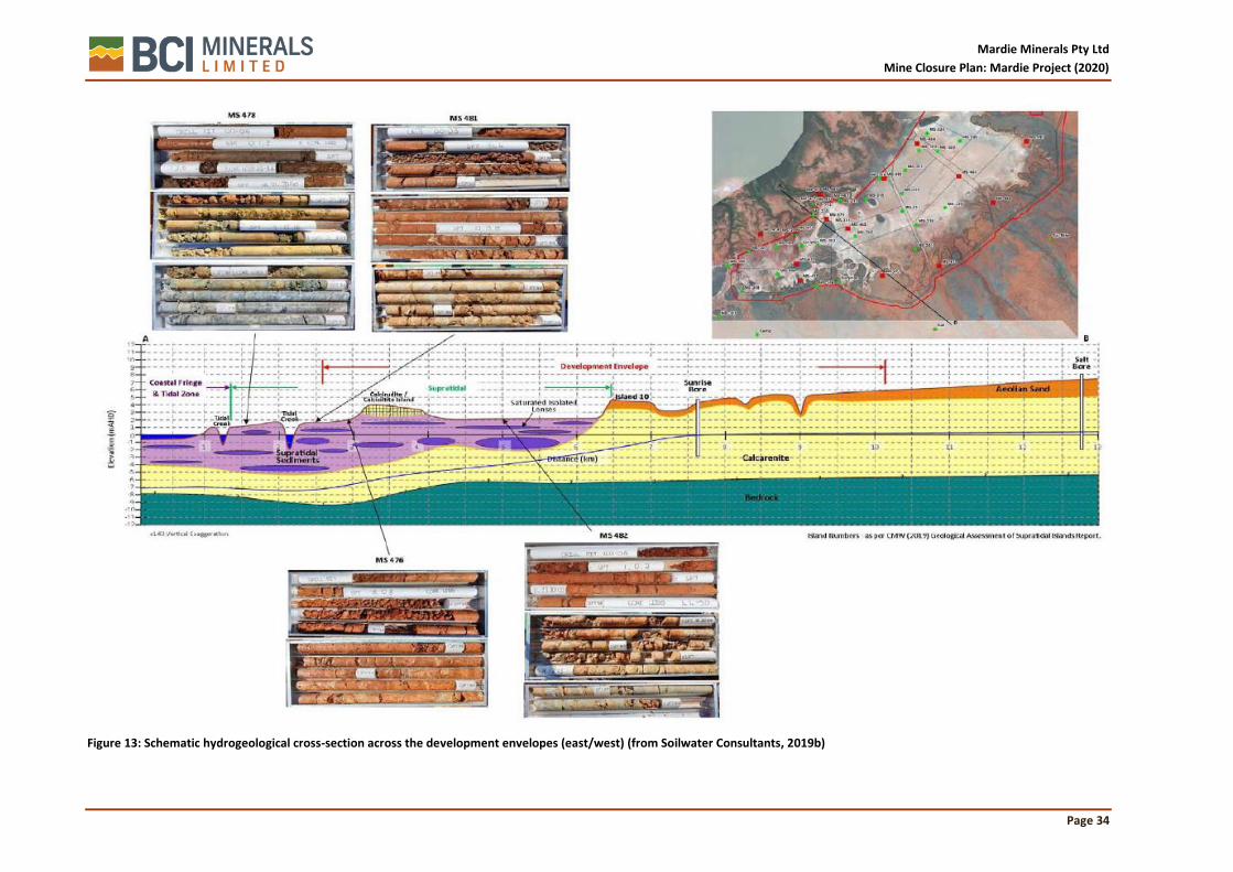
Mardie Minerals Pty Ltd
Mine Closure Plan: Mardie Project (2020)
Page 34
Figure 13: Schematic hydrogeological cross-section across the development envelopes (east/west) (from Soilwater Consultants, 2019b)

Mardie Minerals Pty Ltd
Mine Closure Plan: Mardie Project (2020)
Page 35
The Proposal is generally underlain by a moderately to highly calcreted shelly calcarenite layer, likely equivalent to the regionally extensive Quaternary Bibra Limestone and older Tertiary Bundera Calcarenite. On the eastern side of the Supratidal Flats, the calcarenite is unconformably overlain by Pleistocene to Holocene eolian, alluvial and colluvial sediments forming the current surface of the Onslow Land System. The calcarenite layer dips westerly under the Supratidal Flats (corresponding to the Littoral Land System), creating an undulating surface onto which the mudflats were deposited. In areas where the calcarenite layer outcrops the mudflat surface it anchors a thin veneer of eolian (dunal) sand.
The Supratidal Flats that occur extensively across the development envelopes, on top of the calcarenite layer, have formed by prolonged deposition of terrestrial and marine sediments. Several large creek systems discharge directly into the Supratidal Flats. Depending on the catchment characteristics and the distance from the discharge point, the sediments making-up the Supratidal Flats will vary from heavy clays to sands to gravels, with each deposition event interfingering with the last deposition event.
Groundwater resource description
Groundwater within the Supratidal Flats is confined to friable sand and gravel layers (lenses), with the overlying and underlying (confining) clay layers generally ‘dry’ (i.e. not saturated). The spatial connectivity of the saturated sand / gravel layers is uncertain, but given the salinity of groundwater in these layers is 2 – 5 times that of seawater (i.e. TDS around 140,000 mg/L) it is expected that they are not connected to the marine environment, are not recharged regularly by tidal water and are very sluggish (i.e. very low transmissivities).
Given the groundwater in the deeper pastoral bores are generally only brackish to saline, with TDS values only around 5,000 mg/L, it is clear that groundwater contained within the gravel lenses in the Supratidal Flats is not connected to the regional superficial aquifer contained with calcarenite sediments; this separation is clearly shown in Figure 13.
The quality of the groundwater within the isolated gravel lenses in the Supratidal Flats and the underlying calcarenite aquifer is summarised below:
• Groundwater within the Supratidal Flats is generally neutral, whilst the groundwater in the calcarenite aquifer is more alkaline, likely reflecting the presence of the calcarenite. The majority of the alkalinity is in the form of Bicarbonate, with minor Carbonate alkalinity;
• Groundwater within the Supratidal Flats is hypersaline, with 2 - 5 times higher salinity than seawater; likely due to its sluggish permeability and resulting evaporative concentration of salts. The groundwater in the calcarenite aquifer is brackish to saline. All groundwater is generally classified as NaCl type, although groundwater in the Supratidal Flats may also be considered CaSO4 type, likely reflecting the formation of gypsum;
• All groundwater in the development envelopes has low to very low nutrient levels; and
• All groundwater in the development envelopes has low levels of measured metals, although some bores contain elevated Zn and minor Cd and Cu.
5.6 Biodiversity
5.6.1 Survey effort
A number of different specialist consultancies have been engaged to undertake a variety of biological surveys relevant to the project:
• Stantec – mangrove and algal mat distribution;
• Phoenix Environmental Sciences – terrestrial vegetation and fauna;
• O2 Marine – intertidal and subtidal habitats and fauna.
The different survey areas are shown in Figure 14.

Mardie Minerals Pty Ltd
Mine Closure Plan: Mardie Project (2020)
Page 36
Figure 14: Boundaries of different Study Areas

Mardie Minerals Pty Ltd
Mine Closure Plan: Mardie Project (2020)
Page 37
Figure 15: Locations of conservation significant flora (Phoenix, 2019a)

Mardie Minerals Pty Ltd
Mine Closure Plan: Mardie Project (2020)
Page 38
5.6.2 Flora
The following information has been sourced from Phoenix (2019a) unless noted otherwise.
A total of 250 flora taxa representing 41 families and 115 genera identified to species level were recorded in the Study Area during the field surveys. Phoenix reported that the level of floristic diversity present in the Study Area was lower than that indicated from the desktop assessment. This may have been due to the survey area containing extensive claypans that supported little to no vegetation, as well as the generally poor condition of the terrestrial vegetation communities as a result of grazing and heavy weed infestation.
Threatened and Priority Flora
Thirty-four significant flora species were identified in the desktop review as potentially occurring in the Study Area. These were all priority flora species under the BC Act, however one species, Eleocharis papillosa, is also listed as Threatened under the EPBC Act.
Targeted searches were undertaken for significant flora species identified in the desktop review. The searches focused on habitats considered likely to support significant flora, in addition to previously recorded locations of significant plants or populations in close proximity to the study area.
One Threatened Flora listed under the EPBC Act (Minuria tridens) was recorded during the field surveys. This species is also listed as a P1 Priority Flora under the BC Act. It was recorded at one location within the Study Area; a single plant was located on a sand dune in Triodia epactia and Cenchrus ciliaris grassland. This record lies outside any of the proposed disturbance envelope (Figure 15).
One other Priority flora species was recorded in the Study Area during the survey; Goodenia nuda (P4) (Figure 15). This species was recorded at one location near the southern boundary of the Study Area in a low Eucalyptus victrix woodland over tall open Acacia coriacea subsp. pendens shrubland over low Eragrostis brownii, Eulalia aurea and Triodia wiseana grassland. This record also lies outside any of the disturbance envelope. A total of 117 previous records of the species have been reported across the Gascoyne, Little Sandy Dessert and Pilbara Bioregions.
Unidentified or undescribed species
A total of 25 taxa could not be identified to species level, in most instances due to insufficient taxonomic characters as plants were sterile (lacking reproductive structures). A further five taxa were identified to species level but lacked sufficient taxonomic characters to determine the sub-species or variety (Phoenix, 2019a).
5.6.3 Vegetation
The following information has been sourced from Phoenix (2019a) unless noted otherwise.
Bioregion
The Study Area is situated primarily (92.5%) within the Roebourne subregion (PIL4) of the Pilbara bioregion. An insignificant proportion (0.1%) falls within the Chichester subregion (PIL1) of the Pilbara bioregion and about 7.4% intersects non-terrestrial areas occupied by marine habitats.
Vegetation condition
The condition of vegetation in the Study Area ranged from Completely Degraded to Excellent. Areas naturally devoid of vegetation in the Study Area (41.3%) were assigned a Not Applicable (N/A) condition rating. All areas rated as Completely Degraded comprised cleared areas only.
The majority of the vegetation in the Study Area (80.8%) was recorded to be in Very Good to Excellent condition, largely as a result of the Tecticornia spp. shrublands and mangroves on the tidal mudflats being subject to little or no disturbance. A small proportion of the Study Area (1.5%) was recorded to be Completely Degraded, i.e. these areas had been cleared and were virtually devoid of any native vegetation. The remaining 19.2% of the Study area was in Degraded to Good condition with

Mardie Minerals Pty Ltd
Mine Closure Plan: Mardie Project (2020)
Page 39
disturbance primarily in the form of weed infestations, particularly *Prosopis spp. and *Cenchrus ciliaris, but also grazing damage from livestock and vehicle tracks.
Vegetation Associations
Five vegetation associations are located within the Study Area based on regional vegetation mapping by Shepherd et al. (2002) (Table 8). All vegetation associations are extensively represented in the Roebourne and Chichester subregions and currently have over 89% pre-European extent remaining and are therefore have the status of ‘Least Concern’.
Table 8: Vegetation associations within the Mardie Project disturbance envelope (Phoenix, 2019a)
Vegetation Association and description Pre-European extent (ha)
Current extent (ha)
% remaining
Extent within Study Area (ha)
82: Hummock grasslands, low tree steppe; snappy gum over Triodia wiseana
2,563,583 2,550,899 99.51 187
117: Hummock grasslands, grass steppe; soft spinifex
82,706 78,097 94.43 26
127: Bare areas; mud flats 177,750 159,595 89.79 9,399
600: Sedgeland; sedges with open low tree savannah; Eucalyptus sp. aff. Aspera over various sedges
67,036 66,955 99.88 141
601: Mosaic: Sedgeland; various sedges with very sparse snakewood / Hummock grasslands, shrub-steppe; kanji over soft spinifex.
109,687 109,618 99.94 7,664
Site vegetation types
Twenty-one vegetation types were mapped by Phoenix (2019a) within the Study Area during the field survey (Figure 16), including:
• Nine low open Tecticornia spp. shrublands on tidal mudflats and sandy rises on tidal mudflats;
• A mangrove community on tidal mudflats and tidal creeks; • Four spinifex (Triodia spp.) steppe; • A Spinifex longifolia grassland; • A Melaleuca argentea and Sesbania formosa woodland; • A shrubland over Triodia spp. Grassland; • A low open Eucalyptus spp. woodland over Acacia spp. shrubland over Triodia spp.
Hummock grassland; • A low mixed grassland, Eragrostis spp.; • A Prosopis spp. tall shrubland; and • A low shrubland over Sporobolus virginicus grassland.
A large proportion of the Study Area (42.2%) was devoid of the flora and vegetation that were the subject the surveys. These areas comprised coastal beaches, tidal mudflats, tidal creeks, ocean, algal mat, areas that were naturally devoid of vegetation and completely degraded/cleared areas including gas pipeline corridors, pastoral tracks and areas that had been cleared for pastoral activities.
The majority of vegetation types defined for the Study Area align with vegetation types defined for other surveys in the region indicating a broader distribution outside of the Study Area.
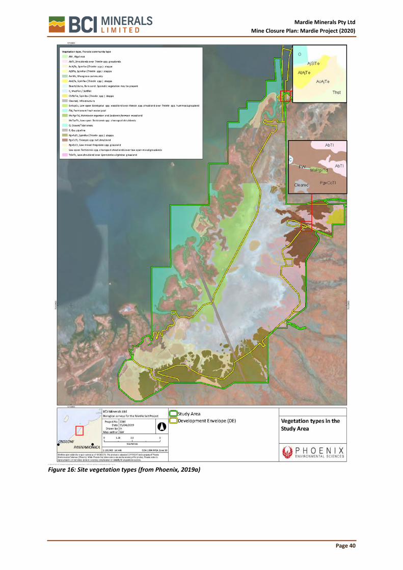
Mardie Minerals Pty Ltd
Mine Closure Plan: Mardie Project (2020)
Page 40
Figure 16: Site vegetation types (from Phoenix, 2019a)

Mardie Minerals Pty Ltd
Mine Closure Plan: Mardie Project (2020)
Page 41
Threatened and Priority Ecological Communities
One Endangered Threatened Ecological Community (TEC) listed under the EPBC Act (Robe Valley Mesas – Subterranean invertebrate communities of mesas in the Robe Valley region) and three Priority Ecological Communities (PECs) listed under the BC Act were identified in the desktop study however, all were recorded at least 30 km away from the Study Area.
During the field survey, vegetation associated with the Horseflat land system of the Roebourne Plains PEC (Priority 3) was identified within the Study Area. The description of the Horseflat land system of the Roebourne Plains PEC is considerably broad with no obvious distinguishing features specified. Advice was sought from DBCA Species and Communities Branch concerning the characteristics and a determination of the mapped areas, and it was confirmed that the characteristics of the mapped areas within the Study Area do align with this PEC. 350 ha of this PEC was recorded within the Study Area.
Weed Species
Introduced flora pose threats to biodiversity and natural values by out-competing native species for available nutrients, water, space and sunlight; reducing the natural structural and biological diversity by smothering native plants or preventing them from growing back after clearing, fire or other disturbance; replacing the native plants that animals use for shelter, food and nesting; and altering fire regimes, often making fires hotter and more destructive (AWC 2007).
Weeds have the potential to be introduced to the area or spread as a result of the Proposal, with the greatest risks associated with earthmoving during the construction period. The Prosopis infestation at Mardie Station has a long history, dating back to the 1930’s and is recognised as the largest single core infestation (150,000 ha) in Australia (NHT, 2003). The Pilbara Mesquite Management Committee (PMMC) formed in 2000 has acknowledged that eradication of the species at Mardie is unachievable and instead the priority is to prevent the spread of the pest to neighbouring areas (NHT, 2003). In 2019 PMMC consolidated all know Mesquite data and presented it to the Department of Primary Industries and Regional Development to demonstrate the extent of the infestation and management measures currently in place. The map is presented in Figure 17.

Mardie Minerals Pty Ltd
Mine Closure Plan: Mardie Project (2020)
Page 42
Figure 17: West Pilbara Mesquite Infestation Map – Prepared for DPIRD by PMMC September 2019

Mardie Minerals Pty Ltd
Mine Closure Plan: Mardie Project (2020)
Page 43
5.6.4 Benthic communities and habitats
Benthic Community habitats (BCH) are defined as biological communities that inhabit the seabed, including substrates within the subtidal and intertidal zones, which are important to primary or secondary production (EPA, 2016). Mardie Minerals commissioned a series of increasingly detailed BCH surveys (Stantec 2018; O2 Marine 2019). The results of the surveys are summarised below in Table 9, with the distribution of the different BCH types mapped out in Figure 18.
Table 9: Benthic community habitats associated with the Mardie Project (from O2 Marine, 2019)
Habitat Type Example Image
Intertidal: Algal mat
Algal mats are typically green to grey or black, and either contiguous or fragmented. 11 species were identified with filamentous cyanobacteria Microcoleus sp. and Lyngbya sp. dominating.
Algal mat communities predominantly occur within the central and northern sections of the Study Area. They occur within a relatively nominal elevation of 1.1 to 1.3 m AHD where they form vast shallow lakes at high tides (>1.2m).
The algal mats at Mardie are considered representative of algal mat communities occurring in similar sites within the Pilbara region, including Exmouth Gulf and south of Onslow (Stantec, 2018).
Intertidal: Foreshore mudflat/ tidal creek
A variety of benthic habitat types from flat fine to coarse sands, flat mud, sparse to high macroalgae, and low to moderate seagrasses were identified occurring within Foreshore Mudflats/Tidal Creeks.
Tidal creeks are typically well established within the southern section of the Study Area and become sparser moving north. Foreshore mudflats extend over a wider area through the central section.
Intertidal: Mangroves – closed canopy
Closed canopy (CC) mangroves comprise the greater structural complexity, typically higher seaward mangrove associations. Avicennia marina dominate the species with Rhizophora stylosa the sub dominant species.
CC mangrove communities occur as ribbons along the coastline and fringing tidal creeks, with more vast forest occurring within the southern section, particularly within the boundary of the Robe River Delta.
The major contributing factor for mangrove distribution is the salinity gradient, with the less tolerant R. stylosa generally occurring seaward of A. marina.

Mardie Minerals Pty Ltd
Mine Closure Plan: Mardie Project (2020)
Page 44
Habitat Type Example Image
Intertidal: Mangroves – scattered canopy
Scattered canopy (SC) mangroves comprise the least structural complexity, typically lower landward mangrove associations. A. marina dominate the species with Ceriops australis also observed.
SC mangroves are the most extensive mangrove functional groups representing over 64% of all mangrove communities. They are typically located on the landward extents extending over wide intertidal mudflat areas with the largest areas occurring in the central and southern sections of the Study Area.
Intertidal: Samphire mudflat
Samphire/Samphire Mudflats are widely and extensively distributed, comprising approximately 24% of the mapped intertidal BCH. They are typically located on the landward extent of mangroves, whilst through the centre of the Study Area they are on the seaward extent of algal mats, with a smaller community in the north seaward of terrestrial vegetation.
Intertidal: Mudflat/ saltflat
Mudflat/Saltflats are extremely low in biodiversity and support little to no associated fauna or flora due to their characteristic high salinities.
Mudflat/Saltflats are the dominant intertidal BCH comprising 33% of the total mapped BCH area. They typically occur on the higher intertidal gradients on the landward extent of samphires or algal mats.
Subtidal: Bare Silt / Sand
Typically comprises of silt or sand with no or occasional very sparse macroalgae. Silt areas often comprised of bioturbation (burrows formed by living organisms). Sand areas often contain traces of shell grit.
This habitat comprises 89% of the subtidal BCH within the Study Area and is also widely dispersed across the region.
Subtidal: Sand / Sparse (<5%) Macroalgae
Fine silt/sand and bioturbated bedform with a very patchy distribution of macroalgae and invertebrates.
This habitat comprises 1% of the subtidal BCH within the Study Area. Regionally, it was also observed on the eastern fringing waters of Round Island, whilst the largest contiguous area was observed closer to the mainland in the shallow waters between Angle Island and the mainland.

Mardie Minerals Pty Ltd
Mine Closure Plan: Mardie Project (2020)
Page 45
Habitat Type Example Image
Subtidal: Sand / Sparse (<5%) Filter Feeders
Sparse filter feeder habitat occurs where the relief is flat and is associated with fine to coarse sands. Although only present in sparse densities (<5% cover), hydroids are most common where there is no bedform, whilst sponges occur where there is some bioturbation.
This habitat comprises 2% of the subtidal Study Area and is widely dispersed throughout the region.
Subtidal: Low (5-10%) Cover Macroalgae / Filter Feeders
Flat to low relief constituting either fine to coarse sands, including shell grit on occasions. Macroalgae, hydrozoan and sponge species are equally dispersed throughout this habitat although benthic cover is low (3-10%). Occasional very sparse (<1%) cover of Halophila sp. seagrass was also observed at some locations.
This habitat comprises 6% of the subtidal BCH within the Study Area and follows a patchy distribution throughout the region.
Subtidal: Low (5-10%) Cover Coral
Flat to low relief rock and rubble with coarse sand. Low (3 - 10%) cover of soft and hard corals, including Faviidae, Dendrophyllidae, Mussidae and Octocroals. Sparse macroalgae was also present.
This habitat comprises 1% of the subtidal BCH within the Study Area. Elsewhere, this habitat was also found fringing Mardie Island and in small isolated patches between Angle Island and the mainland. It was generally recorded in waters between 1-3 m depth.
Subtidal: Moderate (10-25%) Cover Coral / Macroalgae
Low to moderate relief rock and rubble/coarse sand. Low to moderate cover (3 – 25%) of soft and hard corals with macroalgae. Corals largely consisted of Faviidae, Poritidae, and Octocorals, while Phaeophyceae dominated the macroalgae communities.
This habitat class comprises only 1% of the subtidal BCH within the Study Area. Elsewhere, it was recorded in larger areas in fringing shallow waters south of Mardie Island and adjacent to the mainland coast.

Mardie Minerals Pty Ltd
Mine Closure Plan: Mardie Project (2020)
Page 46
Habitat Type Example Image
Subtidal: Dense (>25%) Cover Macroalgae / Coral / Filter Feeders
This habitat class occurs on low relief substrate with fine to coarse sands and areas of exposed limestone reef. Dense assemblages (>75%) of macroalgae and hydrozoan species predominately in waters at depths of 2.2 - 4.0 m. This habitat also supported sparse juvenile corals (Faviidae, Dendrophyllidae, Mussidae) with occasional larger coral (Poritidae) bombies (1 - 2m diameter).
This habitat class comprised <1% of the subtidal BCH in the Study Area. It was also identified in the waters fringing the eastern outer edge of Long Island, Round Island and Sholl Island.
Subtidal: Dense (>25%) Cover Coral Dominated
Low relief limestone reef and rubble substrate which supports high coral cover (25%-75%) of diverse coral species, including Faviidae, Dendrophyllidae, Mussidae, Portitidae, and Octocoral species.
This habitat class was only recorded at one location in the Study Area and, as such, comprises only <1% of the subtidal BCH. It was also recorded incidently in a much larger area, fringing the northern edge of Mardie Island.

Mardie Minerals Pty Ltd
Mine Closure Plan: Mardie Project (2020)
Page 47
Figure 18: BCH distribution across the survey areas

Mardie Minerals Pty Ltd
Mine Closure Plan: Mardie Project (2020)
Page 48
5.6.5 Terrestrial fauna habitats
Twelve terrestrial fauna habitats were recorded in the project study area, based largely on the type of vegetation cover (Table 10). The terrestrial fauna study area overlaps the intertidal BCH study area, as many terrestrial animals rely on BCH for feeding, refuge, and nesting, so consistent classifications are used, where possible.
Table 10: Terrestrial fauna habitat types and their proportion of the study area
Habitat Mapped extent within Study Area (ha) Percentage of Study Area
Mudflat or saltflat 9,186.5 32.65%
Tidal samphire mudflats 5,901.0 20.97%
Spinifex grassland 4,675.9 16.62%
Tidal channel and ocean 2,424.7 8.62%
Shrubland 1,947.5 6.92%
Prosopis shrubland 1,755.5 6.24%
Mangrove community 1,680.2 5.97%
Cleared 241.9 0.86%
Samphire shrubland 241.7 0.86%
Open woodland (riparian) 73.5 0.26%
Beach and dune 8.1 0.03%
Fresh water pool 0.4 0.00%
Total 28,136.8 100.00%
The most widespread habitat type was the mudflat/ saltflat, which is largely barren and supports very few animal species. The spinifex grasslands supported the largest number of species overall, but few significant terrestrial fauna species, and is heavily affected by grazing and Mesquite. The mangrove communities, tidal channels, and tidal samphire mudflats were identified as the most important habitat for Migratory shorebirds, and are widespread throughout the region and in generally excellent condition.
5.6.6 Terrestrial fauna
Phoenix Environmental Sciences Pty Ltd (Phoenix) was commissioned to undertake a Level 2 targeted terrestrial fauna assessment for the Project, comprising a suite of fauna surveys designed and timed to address specific faunal groups and species.
Surveys
A desktop review was undertaken previously in September 2017 to identify significant fauna and fauna habitat that may be present in the two Study Areas (Figure 14). This included searches of relevant biological databases and a literature review of previous nearby surveys.
Field surveys were undertaken between December 2017 and February 2019. They included Migratory shorebird and marine turtle surveys using ground and aerial counts, deployment of autonomous recording units to target bats and Night Parrot and searches for other conservation significant fauna and short-range endemic (SRE) invertebrates. The surveys were conducted in accordance with State and Federal government agency guidelines.
Survey results
The desktop study identified records of 277 terrestrial vertebrate fauna species, including 60 conservation significant species within the vicinity of the Terrestrial Fauna Study Area (TFSA). This

Mardie Minerals Pty Ltd
Mine Closure Plan: Mardie Project (2020)
Page 49
included 22 species listed as Threatened, Conservation Dependent or Specially Protected under the EPBC Act and/or the BC Act.
Table 11: Summary of desktop and field terrestrial fauna species recorded
Parameter Mardie desktop Mardie Project
Species 277 163
Genera 179 114
Families 78 62
Introduced species 9 5
Conservation significant species 60 33
A total of 163 vertebrate species were recorded in the field surveys. Of these, birds were the most diverse Class with a total of 126 bird species recorded. The assemblage also comprised 17 mammals, including five introduced species, 19 reptile species and a single amphibian. The TFSA and MSSA contain predominantly intertidal habitats, including samphire mudflats, mangroves, tidal channel/ocean and upper mudflat/saltflat. Several upland habitats were present in lower abundance representing a mix of grasslands, shrublands and woodlands.
A total of 31 conservation significant vertebrate species were recorded in the surveys, including 26 birds (20 of which are EAAF shorebird species), two mammals and three reptiles, all marine turtles. All significant birds recorded are listed as Migratory under the EPBC Act and/or BC Act. The two significant mammals recorded were both bats: Pilbara Leaf-nosed Bat (VU EPBC and BC Acts) and Northern Coastal Free-tailed Bat (Priority 1). Nesting records were observed for Flatback Turtle and Hawksbill Turtle on beaches in the north of the TFSA and Green Turtles were observed foraging offshore and in abundance in the tidal creek channels in the TFSA; all three species are listed as Vulnerable under the EPBC Act and BC Act.
Mammals
The Pilbara Leaf-nosed Bat (Rhinonicteris aurantia Pilbara) is listed as Vulnerable under both the EPBC Act and the BC Act, and was recorded at two riparian open woodland habitats and a creek that was flowing due to recent rainfall. Pilbara Leaf-nosed bats roost in warm and humid caves. At night, individuals disperse outside of their caves to forage in the open, often over open water. In the Pilbara, this habitat is almost exclusively present in large creek beds and gorges. Pilbara Leaf-nosed bats also forage over Triodia grasslands, usually flying close to the ground up to 3 m high. The permanent pool that occurs on one of the creeks is likely to be regularly used for foraging by this species. No roosting habitat was present in the TFSA.
The Northern Coastal Free-tailed Bat (Ozimops cobourgianus) is listed by DBCA as a Priority 1 fauna and was recorded across the mangal community and tidal samphire shrublands, and also ‘inland’ east of the mudflat playa, suggesting fairly wide-ranging foraging activity. The Northern Coastal Free-tailed Bat is a geographically isolated, mangrove-obligate species that occurs in rainforest, monsoon forest riparian zones and mangrove communities.
The Short-tailed Mouse (Leggadina lakedownensis) is listed by DBCA as a Priority 4 fauna and was considered likely to occur within the TFSA, but was not recorded during the field surveys. This species occupies a variety of habitats including hummock and tussock grasslands, tropical woodlands, samphire, sedgelands and stony ranges, and suitable habitat (i.e. low Tecticornia shrublands) was recorded in the TFSA.
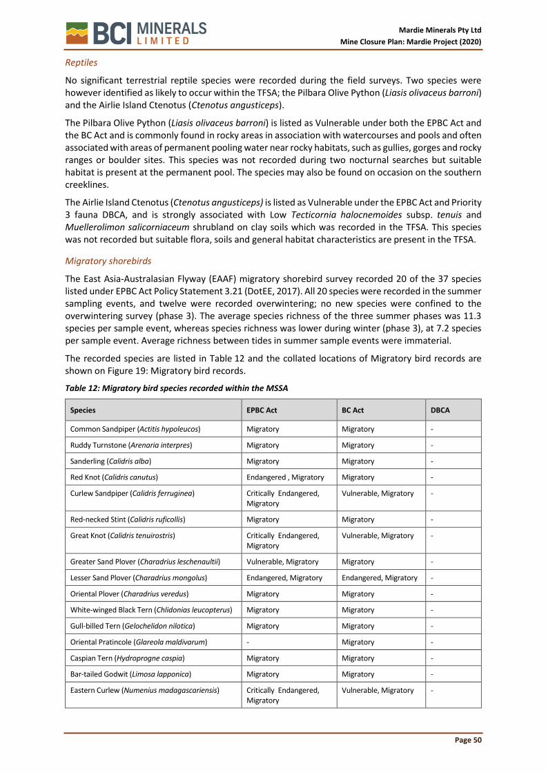
Mardie Minerals Pty Ltd
Mine Closure Plan: Mardie Project (2020)
Page 50
Reptiles
No significant terrestrial reptile species were recorded during the field surveys. Two species were however identified as likely to occur within the TFSA; the Pilbara Olive Python (Liasis olivaceus barroni) and the Airlie Island Ctenotus (Ctenotus angusticeps).
The Pilbara Olive Python (Liasis olivaceus barroni) is listed as Vulnerable under both the EPBC Act and the BC Act and is commonly found in rocky areas in association with watercourses and pools and often associated with areas of permanent pooling water near rocky habitats, such as gullies, gorges and rocky ranges or boulder sites. This species was not recorded during two nocturnal searches but suitable habitat is present at the permanent pool. The species may also be found on occasion on the southern creeklines.
The Airlie Island Ctenotus (Ctenotus angusticeps) is listed as Vulnerable under the EPBC Act and Priority 3 fauna DBCA, and is strongly associated with Low Tecticornia halocnemoides subsp. tenuis and Muellerolimon salicorniaceum shrubland on clay soils which was recorded in the TFSA. This species was not recorded but suitable flora, soils and general habitat characteristics are present in the TFSA.
Migratory shorebirds
The East Asia-Australasian Flyway (EAAF) migratory shorebird survey recorded 20 of the 37 species listed under EPBC Act Policy Statement 3.21 (DotEE, 2017). All 20 species were recorded in the summer sampling events, and twelve were recorded overwintering; no new species were confined to the overwintering survey (phase 3). The average species richness of the three summer phases was 11.3 species per sample event, whereas species richness was lower during winter (phase 3), at 7.2 species per sample event. Average richness between tides in summer sample events were immaterial.
The recorded species are listed in Table 12 and the collated locations of Migratory bird records are shown on Figure 19: Migratory bird records.
Table 12: Migratory bird species recorded within the MSSA
Species EPBC Act BC Act DBCA
Common Sandpiper (Actitis hypoleucos) Migratory Migratory -
Ruddy Turnstone (Arenaria interpres) Migratory Migratory -
Sanderling (Calidris alba) Migratory Migratory -
Red Knot (Calidris canutus) Endangered , Migratory Migratory -
Curlew Sandpiper (Calidris ferruginea) Critically Endangered, Migratory
Vulnerable, Migratory -
Red-necked Stint (Calidris ruficollis) Migratory Migratory -
Great Knot (Calidris tenuirostris) Critically Endangered, Migratory
Vulnerable, Migratory -
Greater Sand Plover (Charadrius leschenaultii) Vulnerable, Migratory Migratory -
Lesser Sand Plover (Charadrius mongolus) Endangered, Migratory Endangered, Migratory -
Oriental Plover (Charadrius veredus) Migratory Migratory -
White-winged Black Tern (Chlidonias leucopterus) Migratory Migratory -
Gull-billed Tern (Gelochelidon nilotica) Migratory Migratory -
Oriental Pratincole (Glareola maldivarum) - Migratory -
Caspian Tern (Hydroprogne caspia) Migratory Migratory -
Bar-tailed Godwit (Limosa lapponica) Migratory Migratory -
Eastern Curlew (Numenius madagascariensis) Critically Endangered, Migratory
Vulnerable, Migratory -

Mardie Minerals Pty Ltd
Mine Closure Plan: Mardie Project (2020)
Page 51
Species EPBC Act BC Act DBCA
Whimbrel (Numenius phaeopus) Migratory Migratory -
Osprey (Pandion cristatus (haliaetus)) Migratory Migratory -
Pacific Golden Plover (Pluvialis fulva) Migratory Migratory -
Grey Plover (Pluvialis squatarola) Migratory Migratory -
Crested Tern (Sterna bergii) Migratory Migratory -
Common Tern (Sterna hirundo) Migratory Migratory -
White-shafted Little Tern, Little Tern (Sternula albifrons)
Migratory Migratory -
Grey-tailed Tattler (Tringa brevipes) Migratory Migratory Specially protected
Common Greenshank (Tringa nebularia) Migratory Migratory -
Terek Sandpiper (Xenus cinereus) Migratory Migratory -
The MSSA directly met two of the threshold criteria for nationally important habitat for Migratory shorebirds; that is, it supports at least 15 East Asian-Australasian Flyway species and, six EAAF species were recorded in excess of 0.1% of their flyway population, in a single sample event: Bar-tailed Godwit, Eastern Curlew, Grey-tailed Tattler, Ruddy Turnstone, Sanderling and Whimbrel.
However, each of the 26 sample events surveyed only 25-38% of the MSSA. Therefore, to determine the total abundance of shorebirds and the abundance of each species using the MSSA (considered a contiguous ‘shorebird area’) it was necessary to extrapolate. Having done so it is apparent that the MSSA supports >2,000 shorebird and is therefore a nationally important shorebird area. Further, at the individual species level an additional eight species occur at nationally important numbers: (Common Greenshank, Curlew Sandpiper (CR), Greater Sand Plover (VU), Oriental Plover, Pacific Golden Plover, Red Knot (EN), Red-necked Stint and Terek Sandpiper). And further still, three species are found to occur in internationally important numbers: Grey-tailed Tattler (P4), Ruddy Turnstone, Whimbrel.
Extrapolation of total sample event abundance of all waterbirds, does not meet threshold criteria for internationally important habitat (i.e. least 20,000 waterbirds).
However, when the data is analysed at the scale of the Development Envelope and Indicative Disturbance Footprint, no criteria are met at either the national or international scales for either assemblage or individual species abundance.

Mardie Minerals Pty Ltd
Mine Closure Plan: Mardie Project (2020)
Page 52
Figure 19: Migratory bird records
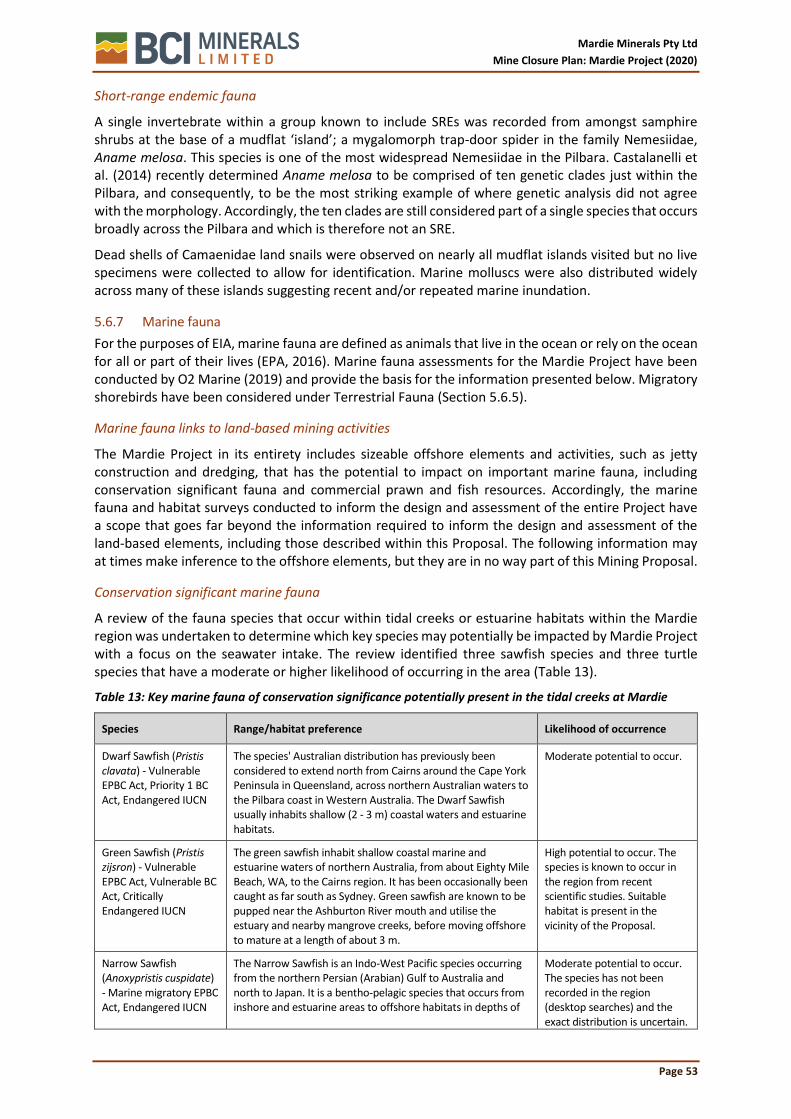
Mardie Minerals Pty Ltd
Mine Closure Plan: Mardie Project (2020)
Page 53
Short-range endemic fauna
A single invertebrate within a group known to include SREs was recorded from amongst samphire shrubs at the base of a mudflat ‘island’; a mygalomorph trap-door spider in the family Nemesiidae, Aname melosa. This species is one of the most widespread Nemesiidae in the Pilbara. Castalanelli et al. (2014) recently determined Aname melosa to be comprised of ten genetic clades just within the Pilbara, and consequently, to be the most striking example of where genetic analysis did not agree with the morphology. Accordingly, the ten clades are still considered part of a single species that occurs broadly across the Pilbara and which is therefore not an SRE.
Dead shells of Camaenidae land snails were observed on nearly all mudflat islands visited but no live specimens were collected to allow for identification. Marine molluscs were also distributed widely across many of these islands suggesting recent and/or repeated marine inundation.
5.6.7 Marine fauna
For the purposes of EIA, marine fauna are defined as animals that live in the ocean or rely on the ocean for all or part of their lives (EPA, 2016). Marine fauna assessments for the Mardie Project have been conducted by O2 Marine (2019) and provide the basis for the information presented below. Migratory shorebirds have been considered under Terrestrial Fauna (Section 5.6.5).
Marine fauna links to land-based mining activities
The Mardie Project in its entirety includes sizeable offshore elements and activities, such as jetty construction and dredging, that has the potential to impact on important marine fauna, including conservation significant fauna and commercial prawn and fish resources. Accordingly, the marine fauna and habitat surveys conducted to inform the design and assessment of the entire Project have a scope that goes far beyond the information required to inform the design and assessment of the land-based elements, including those described within this Proposal. The following information may at times make inference to the offshore elements, but they are in no way part of this Mining Proposal.
Conservation significant marine fauna
A review of the fauna species that occur within tidal creeks or estuarine habitats within the Mardie region was undertaken to determine which key species may potentially be impacted by Mardie Project with a focus on the seawater intake. The review identified three sawfish species and three turtle species that have a moderate or higher likelihood of occurring in the area (Table 13).
Table 13: Key marine fauna of conservation significance potentially present in the tidal creeks at Mardie
Species Range/habitat preference Likelihood of occurrence
Dwarf Sawfish (Pristis clavata) - Vulnerable EPBC Act, Priority 1 BC Act, Endangered IUCN
The species' Australian distribution has previously been considered to extend north from Cairns around the Cape York Peninsula in Queensland, across northern Australian waters to the Pilbara coast in Western Australia. The Dwarf Sawfish usually inhabits shallow (2 - 3 m) coastal waters and estuarine habitats.
Moderate potential to occur.
Green Sawfish (Pristis zijsron) - Vulnerable EPBC Act, Vulnerable BC Act, Critically Endangered IUCN
The green sawfish inhabit shallow coastal marine and estuarine waters of northern Australia, from about Eighty Mile Beach, WA, to the Cairns region. It has been occasionally been caught as far south as Sydney. Green sawfish are known to be pupped near the Ashburton River mouth and utilise the estuary and nearby mangrove creeks, before moving offshore to mature at a length of about 3 m.
High potential to occur. The species is known to occur in the region from recent scientific studies. Suitable habitat is present in the vicinity of the Proposal.
Narrow Sawfish (Anoxypristis cuspidate) - Marine migratory EPBC Act, Endangered IUCN
The Narrow Sawfish is an Indo-West Pacific species occurring from the northern Persian (Arabian) Gulf to Australia and north to Japan. It is a bentho-pelagic species that occurs from inshore and estuarine areas to offshore habitats in depths of
Moderate potential to occur. The species has not been recorded in the region (desktop searches) and the exact distribution is uncertain.

Mardie Minerals Pty Ltd
Mine Closure Plan: Mardie Project (2020)
Page 54
Species Range/habitat preference Likelihood of occurrence
up to 100 m. Common in sheltered bays with sandy bottoms and feed on small fish and cuttlefish.
Potential habitat is present in the vicinity of the Proposal.
Green Turtle (Chelonia mydas) - Vulnerable, Migratory, Marine EPBC Act, Vulnerable BC Act, Endangered IUCN
Green Turtles nest, forage and migrate across tropical northern Australia. They usually occur between the 20°C isotherms, although individuals can stray into temperate waters. In Australia, the key nesting and inter-nesting areas (where females live between laying successive clutches in the same season) occur on offshore islands off the Pilbara coast.
High potential to occur. The species has been recorded in the region (desktop searches) and suitable habitat is present in the vicinity of the Proposal.
Flatback Turtle (Natator depressus) - Vulnerable, Migratory, Marine EPBC Act, Vulnerable BC Act
The Flatback Turtle is found only in the tropical waters of northern Australia, Papua New Guinea and Irian Jaya, and is one of only two species of sea turtle without a global distribution. On the North-West Shelf, the major rookeries are on the mid-eastern coast of Barrow Island and at Mundabullangana Station near Cape Thouin on the mainland. These turtles are known to occur in the Pilbara region during all sensitive life-history phases (mating, nesting and inter-nesting).
High potential to occur. The species has been recorded in the region (desktop searches) and suitable habitat is present in the vicinity of the Proposal.
Hawksbill Turtle (Eretmochelys imbricate) - Vulnerable, Migratory, Marine EPBC Act, Vulnerable BC Act, Critically Endangered IUCN
Hawksbill Turtles are found in tropical, subtropical and temperate waters in all the oceans of the world. In Australia, the key nesting and inter-nesting areas (where females live between laying successive clutches in the same season) occur on offshore Islands off Onslow. Reefs from Cape Preston to Onslow are considered important feeding grounds.
Moderate potential to occur. The species has been recorded in the region (desktop searches) and suitable habitat is present in the vicinity of the Proposal.
Marine fauna habitat
A description of marine fauna habitat (BCH) has been provided in section 5.6.4.
Intertidal marine fauna community
An assemblage of fishes and invertebrates is commonly associated with mangrove ecosystems, with some dependant on mangrove ecosystems. Conspicuous among these are fishes known as mud-skippers, certain gastropod molluscs of the families Neritidae, Littorinidae, Potamididae and Ellobiidae, some barnacles, sesarmid and ocypodid crabs and several species of mud lobster and ghost shrimps. A mentioned above, all species belong to taxa that are widespread in the Indo-Pacific region or are endemic to shores of the North-west Shelf but have biogeographic affinities with that region. Many of the fish in mangrove creeks are occasional and sporadic visitors to the system that enter opportunistically during high tides and include groups such as sharks, longtoms, trevallies, queenfish, mackerel, pike and flatheads.
Marine fauna in the algal mat zone are rare, although insects and insect larvae are sometimes seen under the algal mats. The salt flats are predominantly devoid of marine invertebrates (O2 Marine, 2019).
Subtidal marine fauna community
The nearshore area of the Mardie coastline contains a low to moderate abundance of fish and invertebrates, with species richness typically ranging from low in the nearshore areas to high further offshore and surrounding the reef-fringed islands. Marine species within the nearshore area are predominantly tropical and are short lived with high productivity, resulting in life-history traits of high fecundity and high productivity and high input into reproduction during their relatively short life spans. Most species are locally and regionally widespread with dominant species comprising a high proportion (i.e. ~80 - 90%) of marine fauna present. Dominant fishes and invertebrates typically recorded are those known to inhabit muddy / sediment (trawling grounds) habitats which include ponyfish, goatfish, flathead or crabs and prawns, and the mantis shrimp. However, some dominant fish also suit reef and weed habitat (Kangas et al., 2006).

Mardie Minerals Pty Ltd
Mine Closure Plan: Mardie Project (2020)
Page 55
Invertebrates
A diverse range of marine invertebrate fauna exist in the Mardie region, comprising of mostly tropical species associated with macroalgal communities. These macroalgal communities are supported by coral reef, mangroves and subtidal sand and soft bottom habitats. Mangrove communities are known to support a range of invertebrate fauna. Rocky shores also support a variety of mollusc species and other invertebrates (O2 Marine, 2019). These include gastropod molluscs of the families Neritidae, Littorinidae, Potamididae and Ellobiidae, some barnacles, sesarmid and ocypodid crabs and several species of mud lobster and ghost shrimps. All species belong to taxa that are widespread in the Indo-Pacific region or are endemic to shores of the NW Shelf but have biogeographic affinities with that region (O2 Marine, 2019).
Commercial fisheries
Within Mardie project is located adjacent to one of three dedicated prawn fishery nurseries: Fortescue Nursery. The nursery areas are managed as Size Management Fishery Grounds to allow sections of these areas to be fished on a seasonal basis when prawns are considered to have grown to an appropriate size and the area deemed suitable. Whilst fishing occurs adjacent to the coast and not within the tidal creeks, creek systems are considered to support the breeding and nursery of commercial prawn species.
5.7 Social Values
5.7.1 Aboriginal Heritage
The Yaburara Mardudhunera (YM) People and Kuruma Mardudhunera (KM) People are the Traditional Owners associated with the land that underlies the project (Figure 20), with the YM having been previously determined to hold Native Title rights and interests over much of the site.
Mardie Minerals holds fully executed Land Access Deeds with both the YM People and the KM People. The agreements include consultation schedules, specifications for survey timing, scope, methodology and endorsement of resulting reports, as well as grievance mechanisms. Consultation undertaken to date with both groups is included in the Stakeholder Consultation Register (Section 4).
Heritage sites and places
Horizon Heritage Management (Horizon Heritage) was engaged by the YM People to undertake a work program clearance of the Mardie Project. A preliminary search of the Aboriginal Heritage Inquiry System (AHIS) identified nine Registered Sites and Other Heritage Places within or adjacent to the proposed disturbance envelope (Table 14; Figure 20). The subsequent work program clearance surveys were conducted across two trips; one in November 2018 and the second in December 2018. Each trip was attended by representatives of the YM, Horizon Heritage and Mardie Minerals. The surveys identified a number of areas to be demarcated, as well as 30 ‘cultural salvage points’ that would require salvage of material prior to the implementation of the project (largely associated with middens). The location of the demarcated areas and cultural salvage points are shown in Figure 20. The YM People have requested that the archaeological artefacts located in the heritage places identified are salvaged and relocated to the island to be demarcated adjacent to Peter’s Creek prior to Proposal implementation.
5.7.2 European Heritage
A search of WA databases (inHerit) identified one European Heritage site in proximity to the project, namely “Mardie Station homestead and woolshed”, due to their collective historical significance. The homestead is located over 500 m away from the edge of the project and will not be impacted. A 250 m radius exclusion zone has been placed around the woolsheds to ensure the site is not affected by project activities.

Mardie Minerals Pty Ltd
Mine Closure Plan: Mardie Project (2020)
Page 56
5.7.3 Recreation and amenity
Consultation with the management of Mardie Station and also with the City of Karratha confirms that the project site is not associated with, or restrict access to or reduce enjoyment of any recreational activities and social uses, owing to the pastoral land use, lack of public access, and inhospitable coastal landscape.

Mardie Minerals Pty Ltd
Mine Closure Plan: Mardie Project (2020)
Page 57
Table 14: Registered Sites and Other Heritage Places
DPLH Site ID & Name Place Type Status Description and Context
6322, Mardie Creek Burial
Artefacts / Scatter, Ceremonial, Grinding Patches / Grooves, Midden / Scatter, Skeletal Material / Burial, Camp
Registered, Open, No restrictions
This registered burial and occupation site was recorded by M. Lowe and R. Solomon in 1991, and is located near to Mardie Pool and the Mardie Station Wool Shed. The site is part of a story telling how Mardudhunera people were attacked and killed by another Pilbara tribe. This site is incorrectly mapped on the DPLH AHIS as being located within the Wiruwundi Plain but is in fact near Mardie Pool. Mardie Minerals has designed the project to avoid Mardie Pool and the heritage values associated with it by excluding the area from the disturbance envelope.
10351, Wiruwandi Plain Mythological Registered, Open, No restrictions
This registered mythological site was recorded by Dr. Palmer in 1975 and later by Brown in 1979, and extends from Wearawandie Well in the south to Mardie Wool Shed in the north and west of the Mardie-North West Costal Highway Road. It forms part of the Wiruwandi (Boomerang Wood) Dreaming which also includes a hill and a pool. The Plain is adjacent to the project but is not intersected with the disturbance envelope.
11409, Mardie Station A and 114110, Mardie Station B
Artefacts / Scatter, Engraving
Registered, Open, No restrictions
These registered artefacts and engraving sites were recorded by R. Sharpe of Mardie Station. There is very limited information in the site file, and no photographs or notes. Furthermore, it appears both sites are unreliably mapped on AHIS and are thought to be actually located on the nearby Yarraloola Station.
17429, Nyungarrarra (Peters Creek)
Named Place Stored Data / Not a Site, Other Heritage Place, Open, No restrictions
This named place is stored data with DPLH and is not considered a site under the AH Act. It was recorded in 1994 by McDonald, Hales and Associates during a survey of the northern section of the Goldfields Gas Transmission Project. The site is Peters Creek; its Mardudhunera name is Nyungarrarra (meaning ‘blue sky’). The creek has significance to the YM and KM Aboriginal people. The development envelopes are expected to overlap the western extent of this site and a Section 18 application will be lodged to disturb this site.
17833, TAP Site 2 Artefacts / Scatter, Shell Lodged, Other Heritage Place, Open, No restrictions
DPLH considers there is currently insufficient information to register this artefact scatter as a site under the AH Act. It was recorded by Lantzke in 1999 during an archaeological survey of the Mardie Gasfield Exploration Programme. The site consists of a small scatter of shells and flaked stone artefacts made from chert, dolerite and basalt, and is located on the shore of a salt flat island. This place will be impacted by the project; however, the YM People have suggested that salvage and relocation of the artefacts to a demarcated island structure adjacent to Peters Creek will satisfy their heritage management objectives.
22932, Hadson 2 Artefacts / Scatter Lodged, Other Heritage Place, Open, No restrictions
This site is under lodged status at DPLH and is yet to be assessed. It was recorded in 1990 by Murphy and McDonald in conjunction with representatives from the Mardudhunera group. This artefact scatter consists of flaked stone artefacts and shell fragments (Melo spp. Anadara spp.) on a sand plain in a coastal flat. The site will not be disturbed by construction activities but will be flooded. The YM People have suggested that the flooding of the site will provide ongoing protection and will satisfy their heritage management objectives.
22933, Hadson Midden 1
Artefacts / Scatter, Midden / Scatter
Lodged, Other Heritage Place, Open, No restrictions
This site is under lodged status at DPLH and is yet to be assessed. It was recorded in 1990 by Murphy and McDonald in conjunction with representatives from the Mardudhunera group. This artefact scatter and midden consists of flaked stone artefacts and some shells (Saccostrea spp. Terebralia spp. Anadara spp. and Melo spp.) but, because of the presence of coral blocks and mangrove branches, the shell scatter may be natural. The site will
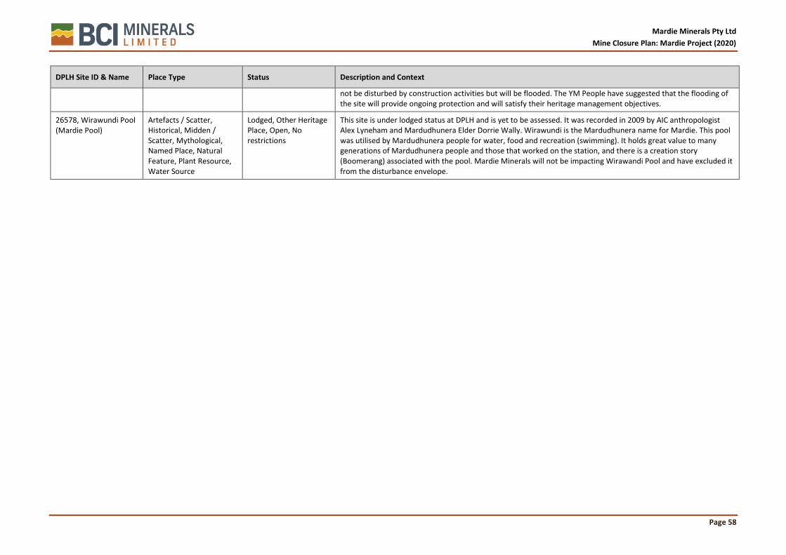
Mardie Minerals Pty Ltd
Mine Closure Plan: Mardie Project (2020)
Page 58
DPLH Site ID & Name Place Type Status Description and Context
not be disturbed by construction activities but will be flooded. The YM People have suggested that the flooding of the site will provide ongoing protection and will satisfy their heritage management objectives.
26578, Wirawundi Pool (Mardie Pool)
Artefacts / Scatter, Historical, Midden / Scatter, Mythological, Named Place, Natural Feature, Plant Resource, Water Source
Lodged, Other Heritage Place, Open, No restrictions
This site is under lodged status at DPLH and is yet to be assessed. It was recorded in 2009 by AIC anthropologist Alex Lyneham and Mardudhunera Elder Dorrie Wally. Wirawundi is the Mardudhunera name for Mardie. This pool was utilised by Mardudhunera people for water, food and recreation (swimming). It holds great value to many generations of Mardudhunera people and those that worked on the station, and there is a creation story (Boomerang) associated with the pool. Mardie Minerals will not be impacting Wirawandi Pool and have excluded it from the disturbance envelope.

Mardie Minerals Pty Ltd
Mine Closure Plan: Mardie Project (2020)
Page 59
Figure 20: Native Title areas and Registered Heritage Sites

Mardie Minerals Pty Ltd
Mine Closure Plan: Mardie Project (2020)
Page 60
5.8 Other closure related data
Mardie Minerals will develop a “base” of information and knowledge important to the closure of the Project landforms and infrastructure (mainly the concentrator and crystalliser domains). The information will be collated from local and global sources throughout the life of mine as research and technologies are identified. The data will be maintained within the Environmental Management System (EMS) and referred to as closure strategies are developed. Brief synopsises of the findings will be included in this section.
5.8.1 Mardie Salt Trial Pond and Ancillary Works
In 2019 DMIRS approved a Programme of Works (Registration ID:81661) for the Mardie Salt Trial Pond and Ancillary Works within “Foreshore”. The basis of the trial is a preliminary investigation and will provide important data required for the construction and decommissioning of the greater salt operation. The trial has been designed with the purpose of:
• Assessing the suitability and performance of the proposed pond wall designs and construction method to be employed by the proposed Mardie Project;
• Testing the proposed Mardie Project pumping strategy; and
• Confirming the pond water balance by tracking losses through evaporation and seepage.
• Refining techniques to capture sediments and maintain environmental integrity.
• Researching and trialing approaches for decommissioning and mine closure.
The trial will also provide Mardie Minerals with the opportunity to build on and refine its capacity to plan and conduct operations in the intertidal area, including sediment control and site rehabilitation.
The period of the trial will be up to two years, with the aim to test the trial pond structure under a range of local conditions. Once the trial is complete and unless the necessary environmental approvals have been secured, Mardie Minerals will decommission the site, returning the nearshore areas to their original topography, and encouraging the return of the pre-disturbance tidal regime and vegetation associations.
The trial is likely to commence in 2020 and relevant findings from the trial will be summarised within future reviews of the Mine Closure Plan.
5.8.2 Study: Shorebird Foraging Ecology in Northwestern Australian Saltworks
In 2015 the Centre for Ecosystem Management, Edith Cowan University, published a report titled Shorebird Foraging Ecology in Northwestern Australian Saltworks (REF). The study was commissioned by Rio Tinto as three of its coast salt operations are listed as Important Bird and Biodiversity Areas by Bird Life Australia and are recognised as globally important habitats for shorebirds. The study developed a knowledge base regarding the ecology of shorebirds on these salt works, the prey resources present, and shorebird interactions within feeding habitats. The information would subsequently allow the formulation of management strategies for these sites that reconcile production requirements with the needs of shorebirds populations and provide a scientific basis upon which saltworks can be managed postproduction. The specific objectives included:
• Identify the major biotic factors that influence shorebird use of the saltworks, with special emphasis on trophic resources.
• Identify the abiotic conditions that affect shorebird habitat use in the
• saltworks.
• Evaluate the quality of the three sites as feeding habitats for shorebirds.
The study highlights the importance of salt operations as foraging and roosting habitat of migratory birds and made several recommendations for both the operational and post-operational phases.

Mardie Minerals Pty Ltd
Mine Closure Plan: Mardie Project (2020)
Page 61
5.8.3 Study: South Bay Salt Pond Restoration Project
The South Bay Salt Pond Restoration Project is a collaborative project between United States government agencies and not for profit organizations to convert salt evaporation ponds in the southern reaches of the San Francisco Bay. The result has been the successful rehabilitation of a combination of tidal salt marsh and managed ponds for wildlife.
The salt ponds were established over 150 years ago with up to 90% of the tidal marsh lost throughout the long history of the industry. In recent years Cargill who own the salt works, sold off and donated a significant area of the operation in order to protect critically endangered animals only known to this location.
The restoration project encompasses 15,000ha and is the largest restoration project on the west coast of Northern America. The project uses the experience of hydrologists and engineers to work out which levees to breach that will enable inwards tidal movement bringing sediments that recreate the mudflats. In addition, natural tidal inflows bring plant material and seeds which passively revegetate the rehabilitated areas.
By breaching the levees and restoring the marshes the restoration project have recorded noticeable improvements in water quality, an influx of native species back to the region and improved flood protection for adjacent businesses.
There are a number of similarities between the South Bay Salt Ponds and Mardie Salt Ponds. It is predicted that many of the findings from the research at South Bay can be adapted and utilized in the Mardie MCP and associated activities. As a result, Mardie Minerals will attempt to connect with the facilitators of the South Bay Restoration Project with the intent to build a relationship and share knowledge.
Although Mardie Minerals has a clear understanding of the natural tidal regimes, further studies will be required to determine the most suitable topography and barrier structures required to capture sediments within the condenser ponds and thereby promoting natural revegetation. Mardie Salt intend to develop sediment budgets by using long term data collection from comparable mud flats to determine the effectiveness of passive rehabilitation as seen in the South Bay Restoration Project.

Mardie Minerals Pty Ltd
Mine Closure Plan: Mardie Project (2020)
Page 62
6 POST-MINING LAND USE
6.1 Considerations
The decision-making process ensures that the PMLU aligns with DMIRS (2015) guidelines which state that the PMLU must be:
• relevant to the environment in which the mine will operate or is operating;
• achievable in the context of post-mining land capability;
• acceptable to the key stakeholders; and
• ecologically sustainable in the context of local and regional environment.
In order to achieve the PMLU Mardie Minerals will rely on comprehensive baseline environmental and reference data collected during the pre-mining/approvals phase of the project. In addition, environmental monitoring data collected during the life of mine will be analysed to understand the direct impacts of the operations and to determine which environmental aspects will require additional resources to achieve the PMLU.
The factors that Mardie Minerals took into consideration when selecting the PMLU were:
• Land tenure
• Heritage
• Acceptability to key stakeholders and
• Compatibility with surrounding area
There is currently a land tenure agreement in place to allow the mining operation to occur on land previously used for pastoral activities (currently operated by Citic Pacific Mining). As part of this agreement it is important that the land is returned to pre-mining conditions, giving the pastoral lease holder the opportunity to continue grazing stock once the project has ceased.
The Yaburara Mardudhunera (YM) People and Kuruma Mardudhunera (KM) People are the Traditional Owners associated with the land that underlies the Proposal. The Proposal is located almost entirely on land in which the YM People have been determined to hold Native Title rights and interests. Considerations to the YM and KM Native Title rights and heritage agreements that exist between Mardie Minerals and the traditional owners have strongly influence the PMLU. Returning the area to the pre-mining condition has been accepted by the traditional owners and is considered appropriate for future customary activities.
6.2 Selection Approach
Mardie Minerals have conducted direct consultation with stakeholders and regulators to determine the most suitable PMLU. Consultations have included;
• YM & KM Traditional Owners
• DMIRS
• PMPL
6.3 Considerations of Offsets
The Mardie Project has not considered offsets as it is not expected that significant residual environmental impacts will exist once closure activities have been implemented. Mardie Minerals have evidence to suggest that impacts from mining activities will be largely reversable and that it will be possible to reinstate “natural” ecosystems to be as similar as possible to the original ecosystem.

Mardie Minerals Pty Ltd
Mine Closure Plan: Mardie Project (2020)
Page 63
6.4 Post Mining Land Use
The decision to reinstate “natural” ecosystems to be as similar as possible to the original ecosystem which includes pastoral and customary activities was made through the direct consultation with stakeholders and regulators in consideration with the key factors dictating the suitability of PMLUs.

Mardie Minerals Pty Ltd
Mine Closure Plan: Mardie Project (2020)
Page 64
7 CLOSURE RISK ASSESSMENT
7.1 Overview
Mardie Minerals has conducted a thorough environmental and social/heritage risk assessment for the Mardie Project, using as guidance the following framework and advisory documents:
• AS/NZS ISO 31 0000: 2009 Risk Management Principles and Guidelines;
• Australian Government Leading Practice Sustainable Development Program for the Mining Industry – Risk Management (2016);
• DMP Code of Practice – Safe design of buildings and structures (2010);
• DMIRS Guidance Note - Environmental Risk Assessment for Mining Proposals and Mine Closure Plans (2018);
• Queensland Government Manual for assessing consequence categories and hydraulic performance of structures (2016).
This section describes the methodology and outcomes of the risk assessment process, including:
• Evaluations of the risks identified in the assessment;
• the measures that will be used to treat risks, using the risk reduction hierarchy of avoid-minimise-mitigate; and
• the evaluations of the residual risks to ensure that the level of each is As Low As Reasonably Practicable (ALARP).
The complete register for the Mardie Project is provided in Attachment 3.
7.2 Methodology
7.2.1 Scope
The risk assessment captures mining activities that will be undertaken on the Mardie Project Mining Tenements throughout all phases of the Project including, construction, operational and closure. In addition, the risk assessment analyses risk associated with standalone closure issues that may result due to closure.
The scope doesn’t include any infrastructure beyond the mining tenements such as the port conveying and loadout facilities.
7.2.2 Risk Assessment Criteria
To ensure that the assessment of the likelihood and consequence levels across the identified risks was consistent, semi-quantitative matrices were developed for the project, based on industry examples.
Table 15: Risk criteria matrix: Likelihood of impact occurring
Descriptor Expected Frequency
Probability
A. Almost Certain More than once per year
The event is expected to occur at some time as there is a history continuous occurrence with similar projects/activities.
91-100%
B. Likely At least once per year
There is a strong possibility the event will occur at as there is a history of frequent occurrence with similar projects/activities.
61-90%
C. Possible At least one in 3 years
The event might occur at some time as there is a history of infrequent occurrence of similar issues with similar projects/activities.
41-60%
D. Unlikely At least once in 10 years
Not expected, but there's a slight possibility it may occur at some time.
11-40%
E. Rare Once in 15 years
Highly unlikely but may occur in exceptional circumstances. 0-10%

Mardie Minerals Pty Ltd
Mine Closure Plan: Mardie Project (2020)
Page 65
Table 16: Risk criteria matrix: Consequence of impact occurring
Factor
Consequence of Risk Outcome
1. Insignificant 2. Minor 3. Moderate 4. Major 5. Severe
Biodiversity/ Flora/Fauna/ Ecosystem
None or insignificant
impact to ecosystem component
(physical, chemical or biological)
expected with no effect on
ecosystem function.
Moderate to minor impact to ecosystem component
(physical, chemical or biological).
Minor off-site
impacts at a local scale.
Minor and short-term impact to high
value or sensitive ecosystem expected
Off-site impacts at
a local scale.
Long-term impact to significant high value or sensitive
ecosystem expected
Long-term impact
on a wide scale
Adverse impact to a listed species
expected.
Irreversible impact to
significant high value or sensitive
ecosystem expected
Irreversible and
significant impact on a wide scale
Total loss of a
threatened species expected
Water Resources
Low impact to isolated area
without affecting water quality
and/or availability to other land users
(such as pastoralists) or water quality
and/or availability that support
ecological function
Contained low impact with
negligible effect on water quality
and/or availability to other land users
(such as pastoralists) or water quality
and/or availability that support
ecological function
Uncontained impact that will materially affect
water quality and/or availability to other land users
(such as pastoralists) or
water quality and availability that
support ecological function. Impacts can be rectified in short-term (5-10
years).
Extensive hazardous impact to water quality
and/or availability to other land users (such as pastoralists) or
water quality and availability that
support ecological
function. Impacts require long-term
(10-20 years) rectification.
Extensive hazardous
impacts to water quality and/or availability to
other land users (such as
pastoralists) or water quality and availability that
support ecological
function. Impact requiring long-
term (20+ years) rectification.
Land Degradation
Negligible impact to isolated area.
Contained low impact, not
impacting on any environmental
value
Uncontained impact, able to be rectified in short-
term without causing pollution or
contamination.
Extensive hazardous impact
requiring long-term rectification.
Uncontained hazardous
impact with residual effect.
Air Quality No detectable impact.
Contained low impact not
impacting on any environmental
value.
Uncontained impact that will
materially affect an environmental
value, but able to be rectified in
short-term
Extensive hazardous impact
on an environmental value requiring
long-term rectification.
Uncontained hazardous
impact with residual effect.

Mardie Minerals Pty Ltd
Mine Closure Plan: Mardie Project (2020)
Page 66
Mine Closure Site is safe, stable a non-polluting and post mining land use is not
adversely affected.
The site is safe, all major landforms
are stable, and any stability or
pollution issues are contained and
require no residual management.
Post-mining land use is not
adversely affected.
The site is safe, and any stability or pollution issues require minor,
ongoing maintenance by
end land-user
The site cannot be considered safe, stable or non-polluting without long-
term management or
intervention. Agreed end land-
use cannot proceed without
ongoing management.
The site is unsafe, unstable and/ or causing
pollution or contamination
that will cause an ongoing residual
affect. The postmining land use cannot be
achieved.
Table 17: Risk criteria matrix: Risk levels
Consequences
1. Insignificant 2. Minor 3. Moderate 4. Major 5. Severe
Like
liho
od
E. Rare 25 (Low) 23 (Low) 20 (Low) 16 (High) 11 (High)
D. Unlikely 24 (Low) 21 (Low) 17 (Moderate) 12 (High) 7 (High)
C. Possible 22 (Low) 18 (Moderate) 13 (High) 8 (High) 4 (High)
B. Likely 19 (Low) 14 (High) 9 (High) 5 (Extreme) 2 (Extreme)
A. Almost Certain 15 (Low) 10 (High) 6 (High) 3 (Extreme) 1 (Extreme)
7.3 Risk Analysis
The risk assessment relies on the comprehensive description of project activities or closure issues, so that associated risks and potential impacts can be identified. A detailed description of all risk pathways for the Mardie Project are listed in Table 18: Mine Closure; Mardie Project Environmental and Heritage Risk Assessment.

Mardie Minerals Pty Ltd
Mine Closure Plan: Mardie Project (2020)
Page 67
Table 18: Mine Closure; Mardie Project Environmental and Heritage Risk Assessment
Item DMIRS Factor
Project Phase
Domain Environmental Risk Pathway
Impact
Like
liho
od
Co
nse
qu
en
ce
Raw Score Treatment/Schedule of Works
Like
liho
od
Co
nse
qu
en
ce
Treated Score
1 Rehabilitation and Mine Closure
Planned Closure
Condenser/Crystalliser Ponds
Final landforms alter catchment flows/inputs due altered drainage.
Reduction in condition of coastal ecosystems including mangroves.
C. 2. 18 (Moderate)
Develop drainage modelling for the final landform design within 10 years of-construction of project. Post closure event monitoring of surface water quality and flooding. Remedial drainage measures based on monitoring and modelling.
D. 2. 21 (Low)
2 Rehabilitation and Mine Closure
Planned Closure
Condenser/Crystalliser Ponds
Residual salt within condenser ponds/crystalliser ponds.
Reduction in habitat condition and use by migratory shore birds.
C. 3. 13 (Moderate)
Investigate the extent of the salt deposits and their implications prior to closure. Develop the most suitable rehabilitation technique; including removal/management.
D. 3. 17 (Moderate)
3 Rehabilitation and Mine Closure
Planned Closure
Condenser/Crystalliser Ponds
Erosion of embankments and drainage structures as a result of major storm events.
Increased levels of turbidity and total suspended solids in downstream surface water quality.
C. 2. 18 (Moderate)
Final landforms to be stabilised; rock armoured or otherwise protected to prevent erosion. Post closure event surface water quality including turbidity and total suspended solids.
D. 2. 21 (Low)

Mardie Minerals Pty Ltd
Mine Closure Plan: Mardie Project (2020)
Page 68
Item DMIRS Factor
Project Phase
Domain Environmental Risk Pathway
Impact
Like
liho
od
Co
nse
qu
en
ce
Raw Score Treatment/Schedule of Works
Like
liho
od
Co
nse
qu
en
ce
Treated Score
4 Rehabilitation and Mine Closure
Planned Closure
Condenser/Crystalliser Ponds
Loss of significant ecosystems established on concentrator/crystalliser pond walls/levees as a result of not protecting such habitats during closure.
Loss of habitat and use by migratory shore birds.
B. 3. 9 (High) Incorporate existing habitats into final landform design. Protect habitat during decommissioning activities.
D. 3. 17 (Moderate)
5 Rehabilitation and Mine Closure
Planned Closure
Open Areas/Borrow pits/surface excavations/Transport corridors
Limited vegetation establishment due to topsoil age (>50years), variable rainfalls, seed availability and herbivory pressures.
Delays to effective vegetation establishment including percent cover and species diversity.
C. 2. 18 (Moderate)
Develop a rehabilitation strategy prior to closure using local and regional best practices. Develop revegetation techniques during progressive rehabilitation activities of inactive open areas (borrow pits).
D. 2. 21 (Low)
6 Rehabilitation and Mine Closure
Planned Closure
Open Areas/Borrow pits/surface excavations/Transport corridors
Invasive weed species colonisation of post mining landforms.
Delays in native vegetation establishment due to weed species out competing native species.
A. 2. 10 (High) Incorporate closure activities and post closure surveillance into the Mardie mesquite management and surveillance plan in consultation with PMMC and Mardie Station.
C. 2. 18 (Moderate)
7 Rehabilitation and
Planned Closure
Process/Ancillary
Unidentified and unmanaged hydrocarbon leaks
Decline or loss of marine environment.
C. 3. 13 (Moderate)
Conduct a preliminary sites investigation for
D. 3. 17 (Moderate)

Mardie Minerals Pty Ltd
Mine Closure Plan: Mardie Project (2020)
Page 69
Item DMIRS Factor
Project Phase
Domain Environmental Risk Pathway
Impact
Like
liho
od
Co
nse
qu
en
ce
Raw Score Treatment/Schedule of Works
Like
liho
od
Co
nse
qu
en
ce
Treated Score
Mine Closure
Infrastructure
and/or spills at the seawater intake.
residual hydrocarbons at seawater intake.
8 Rehabilitation and Mine Closure
Planned Closure
Process/Ancillary Infrastructure
Marine equipment (seawater intakes) not decommission leading to navigational risk causing injury.
Injury or loss of life. D. 4. 12 (Moderate)
Decommissioned all equipment to ensure safety requirements are met. Conduct a third party post closure audit of all decommissioned infrastructure.
D. 2. 21 (Low)
9 Rehabilitation and Mine Closure
Planned Closure
Condenser/Crystalliser Ponds
Residual groundwater salinity from condenser/crystalliser ponds increases groundwater salinity.
Reduction in condition of surrounding mangrove communities.
C. 3. 13 (Moderate)
Conduct groundwater modelling during the operational phase. Develop a contingency plan for post closure brine recovery. Continue to implement plume management strategies and groundwater monitoring post closure.
D. 3. 17 (Moderate)
10 Rehabilitation and Mine Closure
Planned Closure
Process/Ancillary Infrastructure
Residual groundwater salinity from crystalliser seepage.
Reduction in condition of Mardie Pool.
C. 3. 13 (Moderate)
Continue to use seepage recovery bores between Mardie Pool and the crystalliser ponds until background salinity levels are reached. Alternative groundwater source to be provided to Mardie
D. 3. 17 (Moderate)

Mardie Minerals Pty Ltd
Mine Closure Plan: Mardie Project (2020)
Page 70
Item DMIRS Factor
Project Phase
Domain Environmental Risk Pathway
Impact
Like
liho
od
Co
nse
qu
en
ce
Raw Score Treatment/Schedule of Works
Like
liho
od
Co
nse
qu
en
ce
Treated Score
Pool if necessary until natural processes are established.
11 Rehabilitation and Mine Closure
Planned Closure
Process/Ancillary Infrastructure
Unidentified and unmanaged leaks and/or spills from brine transfer pipelines.
Residual contamination of land and soils.
C. 2. 18 (Moderate)
Preliminary site investigation for residual leaks and/or spills. Remediate areas of contamination if identified.
D. 2. 21 (Low)
12 Rehabilitation and Mine Closure
Planned Closure
Process/Ancillary Infrastructure
Access by public to potentially unmanaged infrastructure.
Injury or loss of life. D. 4. 12 (Moderate)
Restriction of all public assesses. Decommission all infrastructure. Conduct a third party post closure audit of all decommissioned infrastructure.
E. 4. 16 (Moderate)

Mardie Minerals Pty Ltd
Mine Closure Plan: Mardie Project (2020)
Page 71
7.4 Identification of closure issues
Closure issues have been identified and prioritised based on the level of risk in which they pose. Closure issues recognised as being significant have associated risks with untreated risk ratings of MODERATE or above. The significant risks identified for the Mardie Project and opportunities for management are discussed in the following section.
7.4.1 Breaching Pond Walls
Before breaching the external pond walls, a detailed decommissioning strategy needs to be established to ensure minimal impact to downstream BCH. The plan would include an option analysis to determine the most suitable way to remove the risks of hypersaline material and to stablilise the landforms in the fastest and most cost-effective manner. This strategy will ensure that final landforms are physically/chemically stable and that any residual pond material is managed to ensure there are no adverse impacts to the environment.
In addition, sediment control techniques during the construction phase will be refined and, where possible, the findings will be utilised during the closure activities.
7.4.2 Brine Seepage
It is probable that a level of seepage will occur in the crystalliser ponds creating a groundwater plume that may migrate towards Mardie Pool (SWG 2019). It is likely that, during the life of mine, mitigation measures, including the installation of abstraction and recovery bores, will be required to alter the hydraulic gradient of the hypersaline plume and mitigate the associated risks. During the closure phase these risks will exist until a point when the source of the seepage has been isolated and the residual plume has been exhausted. During the operation phase, and if abstraction bores are required, Mardie Mineral’s will need to develop a strategy for pumping requirements post closure. This will enable Mardie Minerals to predict the duration/volume of pumping required post closure to ensure Mardie Pool is unaffected.
To prevent further seepage the hypersaline material within the crystalliser pond will need to be managed. Like the condenser pond, an option analysis will be required to determine the most effective method for closure. Options may include capping the residual pond material or flushing the crystalliser pond with seawater back into the concentrator ponds.
7.4.3 Established Ecosystems
It is expected that during the life of mine, condenser pond landforms will provide an increasing level of habitat values to vegetation and fauna, including feeding and roosting habitat for migratory birds. This has become evident in a recent study which has identified three Western Australian salt operations as being listed as important birdlife areas by Bird Life Australia (5.8.2). Investigations into the establishment of ecosystems during the operational phase is key to understanding finalising landform design and how best to manage the ecosystems that rely on the landforms associated with the project.
7.4.4 Landform Stability
Long-term stability and erodibility of the final landforms will require investigation prior to closure taking place. This is important for the concentrator ponds that are subject to wave action during high tides. Prior to closure it must be understood what an acceptable level of sediment loss to the environment and what control measures will be required to stabilise the landforms post closure.
7.4.5 Catchment flows
The design of the final landforms, particularly within the intertidal zone, will be essential to the post-closure function of the landscape. An inadequate design may complicate tidal regime or impede the nutrient pathway across the interdial zone to the mangrove systems. In addition, there is a risk that if

Mardie Minerals Pty Ltd
Mine Closure Plan: Mardie Project (2020)
Page 72
the post closure landforms are not stable then additional pressures could be placed on the intertidal and marine environments due to sediment loading and reduction of light penetration through increased turbidity. Prior to closure and based on data collected during the construction and operational phase a detailed design will be developed (and tested using modelling) to ensure that the post closure landforms meet Mardie Minerals closure objectives.
In order to re-establish tidal inundation and natural hydrological regime, the external pond walls will be breached at strategic locations. There are two key risks associated with this activity that will be considered prior to the activity taking place. The risks include a hypersaline plume of saltwater entering the downstream environment and/or an inundation of sediment due to the loss of stability of the pond wall landforms (see Section 7.4.1).
7.4.6 Re-vegetation and Habitat Recreation
Large scale restoration of salt fields into productive salt flats has not been demonstrated in Western Australia. Although excellent success has been achieved in other parts of the world, such as the South Bay Salt Pond Project in U.S.A. (see Section5.1), how this applies in a local context is largely unknown. Mardie Minerals intend to develop rehabilitation techniques particularly where an opportunity to progressively rehabilitate areas exists.
Arid land rehabilitation is challenging due to the low and unpredictable rainfall, extreme temperatures and strong prevailing winds. Mardie Minerals will refine rehabilitation techniques throughout the life of mine to ensure that rehabilitation objectives are achieved. Mardie Minerals will establish a rehabilitation manual and update it with findings from research and development during progressive rehabilitation activities. The consolidation of rehabilitation knowledge over the life of mine will be a key component to reduce rehabilitation risks and meet closure objectives.
Limited topsoil availability and viability has been identified as a closure issue. It is anticipated that the small amounts of topsoil harvested during construction will not be viable at the end of the mine life and therefore will be utilised during progressive rehabilitation activities. This means that at the during closure, topsoil will need to be recreated through other means. Options include the introduction of soil microbiology and the utilisation of organic material to build soils. Further research will be required to establish a topsoil profile in rehabilitated areas. Findings from this research will be included in a report detailing the final cover designs which will be completed within 10 years of mine construction.
7.4.7 Weed Infestations
During the mine closure phase, the risk of weed infestation will increase due to the expansion of open areas (exposed pond floors, plant sites, redundant work areas) and the increased use of machinery for rehabilitation purposes (landform creation, ripping, contouring, seeding). Although Mardie Minerals will maintain a weed management plan during the life of mine, the plan will be updated leading up to the closure phase to address the increase risks. In addition, the knowledge acquired during the operational phase will be consolidated and included in this plan to ensure the most effective strategies are being implemented.
7.4.8 Residual Hydrocarbons
Several hydrocarbon storage facilities will be located onsite and managed during the operation phase. Although it is Mardie Minerals intention to report and remediate hydrocarbon loss, there is a risk that minor leaks over the life of the project may go undetected. As facilities associated with hydrocarbons are decommissioned, preliminary site investigations will be conducted to demonstrate that such areas are free of contamination.

Mardie Minerals Pty Ltd
Mine Closure Plan: Mardie Project (2020)
Page 73
8 CLOSURE OUTCOMES AND COMPLETION CRITERIA
8.1 Identifying Aspects and Defining Outcomes
Mardie Minerals has developed a comprehensive knowledge of the landscape systems and processes thorough the feasibility and approvals stage of the project. During this phase 6 key aspects have been identified as being critical to both the development and closure of the Project. These aspects underpin the closure outcomes and completion criteria, providing foundation to the risks identified with the project. They include;
1. Surface water hydrological regime 2. Geotechnical stability and landforms 3. Flora and fauna 4. BCH function 5. Marine function 6. Social and heritage value
Using the identified aspects Mardie Minerals has defined closure outcomes as indicated in Table 19.
Table 19: Aspects and Outcomes Identified for the Mardie Project
Aspect Outcome Significance/Justification
Surface water hydrological regime
Surface water patterns, including drainage and tidal regime are reinstated and consistent with regional drainage functions.
RPS, 2019 – Coastal Inundation Studies
2019 Baird – Hydrodynamic Modelling Report
Groundwater quality and hydrological regime.
Groundwater regime and quality will be consistent with pre-mining phase.
SWG 2019 – Seepage modelling and assessment.
Geotechnical stability and landforms
Creation of safe and stable landforms that minimize erosion and supports vegetation.
Worley, 2019 Coastal Engineering Report
Vegetation and habitat Restored landscapes that are comparable to reference vegetation communities established through leading practices restoration techniques and within the constraints of post-mining environment.
Phoenix, 2019 – Detailed flora and vegetation survey
Phoenix, 2019 – Level 2 targeted terrestrial fauna survey
BCH function and sustainability
The rehabilitated BCH has function and resilience comparative to reference BCH.
RPS, 2018 Pre-Feasibility Surface Water Assessment
O2 Marine, 2019 – Intertidal Benthic Communities and Habitat
Soil Water Group 2019 – Seepage Model Results
Marine function and sustainability
To re-establish self-sustaining ecological communities on disturbed areas.
O2 Marine, 2019 – Sediment Quality Assessment
O2 Marine, 2019 – Marine Environmental Quality Plan
Social and Heritage Establish a PMLU that meets the requirement of all stakeholders.
2018 Mardie Heritage Survey
8.2 Establishing reference
Mardie Minerals believes that the true environmental reference will be establish over the life of the mine. Based on the evidences identified in Section 5.1, other coastal evaporative salt mines in Western Australia, have created significant habitat for a range of species over the life of the mine. These habitats are essentially artificial however if they are stable post operation, they may be of significant environmental value and therefore should be protected. Mardie Minerals accepts that the reference will be a hybrid of the pre-mine conditions and the ecosystems establish within context of the mine.

Mardie Minerals Pty Ltd
Mine Closure Plan: Mardie Project (2020)
Page 74
8.3 Attribute identification
Attributes have been identified for each aspect associated with the MCP. Relative attributes were identified by consulting the recommendations made by WABSI (2019) in conjunction with baseline studies conducted as part of the Project development. The attributes are the key factors that would significantly alter an aspect if completion criteria were not achieved. Attributes associated with the project have been included in Table 20.
8.4 Completion criteria
The environmental and social values that may be impacted by the closure of the Mardie Project have been identified through the risk assessment process (Section 6). For each of those values assessed as being at MODERATE (pre-treatment) risk or higher, Mardie Minerals has developed a suite of environmental outcomes that the company will achieve or exceed over closure of the project. These environmental outcomes are consistent with legal obligations, stakeholder expectations, and commitments presented in environmental and other approval documentation including the Mining Proposal.
In addition to incorporating avoidance measures into the project, leading practice risk management controls will also be employed to ensure the outcomes will be achieved, or better. Targeting suitable indicators, monitoring regimes will capture and record the performance of these management controls, which will then be assessed against agreed completion criteria. Underperforming areas can then be quickly identified, and management controls reviewed and expanded as necessary to ensure the outcome is achieved. Performance assessment and compliance reports will be compiled each year and submitted to appropriate stakeholders, as well as being available to other stakeholders on request.
A full list of the completion criteria have been identified in Table 20.

Mardie Minerals Pty Ltd
Mine Closure Plan: Mardie Project (2020)
Page 75
Table 20: Completion criteria and monitoring/timeframes associated with identified MCP outcomes.
Aspect Outcome Completion Criteria Monitoring and Timeframes
Surface water hydrological regime
Surface water patterns, including drainage and tidal regime are reinstated and consistent with regional drainage functions.
Catchment flows and nutrient inputs during weather events will not vary from pre-mining levels.
Once earthworks are complete.
Surface water event monitoring 3 years post closure.
Groundwater quality and hydrological regime.
Groundwater regime and quality will be consistent with pre-mining phase to the extent that social and ecological water requirements are not compromised.
Groundwater levels and quality parameters are comparable to pre-mining levels or unless agreed otherwise prior to closure.
Quarterly groundwater level and quality monitoring in established bore network until completion criteria are achieved.
Geotechnical stability and landform
Creation of safe and stable landforms that minimize erosion and supports vegetation.
Final cover designs are not compromised by erosive forces. Annual erosion and stability monitoring until completion criteria are achieved.
Landforms constructed to design specifications (e.g. slope angles, soil cover, height, erosion control structures, armouring).
Condenser/Crystalliser pond floors are stable, non-polluting and provide comparative foraging and nesting habitat for migratory birds to pre-mining conditions.
Migratory bird surveys 3 years post closure.
Surface water event monitoring 3 years post closure.
Biodiversity
To re-establish self-sustaining ecological communities on disturbed areas.
Vegetation species composition and density, within revegetated areas, are comparative to analogue sites within 5 years post closure.
Analogue sites to be established during operations.
Annual vegetation and fauna monitoring.
Fauna abundance and diversity, within rehabilitated areas, are comparative to analogue sites within 5 years post closure.
Weed abundance within revegetated areas is no greater than comparative analogue sites 5 years post closure.
Analogue sites to be established during operations.
Weed monitoring to be incorporated in annual vegetation monitoring.
Final relinquishment of rehabilitation 5 years after revegetation.
Mangrove communities are unaffected by closure activities. Mangrove monitoring as per Mining Proposal to continue 3 years post closure.
Surface water event monitoring 3 years post closure.
Protection of established ecosystems.
No loss of stable fauna habitats that has established on mine landforms during the life of mine. This would include nesting and roosting habitat for migratory birds.
5 yearly fauna surveys during mine operation to determine the habitat value of mine features such as seawalls and levees.
Annual migratory bird surveys throughout the life of mine.
Marine function Interrelated marine systems have function and resilience comparative to reference marine systems.
Marine environments (seawater intake) are free of contamination including hydrocarbons.
Hydrocarbon monitoring as per Mining Proposal during operation.
Preliminary (contaminated) site investigation immediately after decommissioning seawater infrastructure.
The site is free of marine navigational risks within 2 years post closure.
Post decommissioning third part safety audit.

Mardie Minerals Pty Ltd
Mine Closure Plan: Mardie Project (2020)
Page 76
Aspect Outcome Completion Criteria Monitoring and Timeframes
Social and Heritage Heritage and social values are not compromised.
Pastoral productivity is comparable to pre mining conditions. Analysis of landscape potential (including stocking densities) for the project area.
The heritage and environmental value of Mardie Pool is not compromised by hypersaline plumes post closure.
Groundwater monitoring as per Mining Proposal 2 years post closure.
Continued seepage recovery between Mardie Pool and the crystalliser ponds, based on monitoring data and until pre-mining groundwater quality is achieved.
The site is free of safety risks within 2 years post closure. Post decommissioning third part safety audit.
The Operation is free of contaminated sites 5 years post closure. Preliminary (contaminated) site investigation immediately after decommissioning fuel storage and transfer facilities.

Mardie Minerals Pty Ltd
Mine Closure Plan: Mardie Project (2020)
Page 77
9 CLOSURE IMPLEMENTATION
9.1 Land Disturbance
The Disturbance Envelope within the Mardie tenements is 14,396 ha and is a subset of the Development Envelope referred to the Environmental Protection Authority (EPA; Assessment No. 2167). Up to 3,919.87 ha of land will be disturbed within the Disturbance Envelope. The pond floors will include large areas of barren intertidal mudflats that will not be disturbed by mining activities (refer to Mardie Mining Proposal 2020). Figure 21 provides the proposed layout for the mine activities, as well as the Disturbance Envelope and tenement boundaries. Mining activities have been itemised in Table 21 providing an indication of the disturbance area for each activity and the associated MRF Category and BCI mining domain. This table provides reference to the closure works program described in Section 9.2.

Mardie Minerals Pty Ltd
Mine Closure Plan: Mardie Project (2020)
Page 78
Figure 21: Mining Activities for Key Mining Activites and Other Mining Activites as per MRF Categories described in schedule 1 of the MRF Regulations 2013

Mardie Minerals Pty Ltd
Mine Closure Plan: Mardie Project (2020)
Page 79
Table 21: Mining Activities for each mining domain as per MRF Categories described in schedule 1 of the MRF Regulations 2013
BCI Mine Activity Reference MINE ACTIVITY MRF CATEGORY
Closure Domain M08/525
M08/526
M08/527
L08/184
L08/185
Key Mining Activities
Seawater intake Plant site B Process Infrastructure 0.87
SOP Purification plant Plant site B Process Infrastructure
9.71
Powerplant Plant site B Ancillary Infrastructure
1.30
Reverse osmosis & desalination Plant site B Ancillary Infrastructure
0.61
Waste bitterns transfer pond Dam - saline water or process liquor B Process Infrastructure
1.99 0.96
SOP process water pond Dam - saline water or process liquor B Process Infrastructure
1.46
Process evaporation pond Evaporation Pond A Process infrastructure 1.70
Other Mining Activities
Pond Walls Land (other than land under rehabilitation or rehabilitated land) that is cleared of vegetation and is not otherwise described
C Concentrator Ponds / Crystalliser Ponds
44.73 195.60 116.69
Production pond floors (Vegetated)
Land (other than land under rehabilitation or rehabilitated land) that is cleared of vegetation and is not otherwise described
C Ancillary Infrastructure 1,439.76 869.30 726.66
Drainage (South Drain) Diversion channel or drain B Drainage Channels and Stormwater Diversion Domain
50.98
Drainage (North Drain) Diversion channel or drain B Drainage Channels and Stormwater Diversion Domain
89.45
Drainage (South Diversion) Diversion channel or drain B Drainage Channels and Stormwater Diversion Domain
78.98
Road Transport or service corridor C Transport Corridors
152.66 46.76
Maintenance Workshop Workshops B Ancillary Infrastructure
4.51
Hardstand Laydown or hardstand C Ancillary Infrastructure
14.96
HV/LV Fuel Facility Fuel storage facility B Ancillary Infrastructure
0.87
Admin and Lab Building (other than workshop or camp site) B Ancillary Infrastructure
1.65
Camp Building (other than workshop) or campsite C Ancillary Infrastructure
16.13
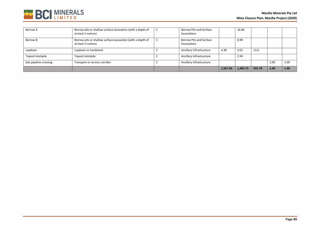
Mardie Minerals Pty Ltd
Mine Closure Plan: Mardie Project (2020)
Page 80
Borrow A Borrow pits or shallow surface excavation (with a depth of at least 5 metres)
C Borrow Pits and Surface Excavations
16.66
Borrow B Borrow pits or shallow surface excavation (with a depth of at least 5 metres)
C Borrow Pits and Surface Excavations
8.99
Laydown Laydown or hardstand C Ancillary Infrastructure 4.38 3.01 13.6
Topsoil stockpile Topsoil stockpile E Ancillary Infrastructure
2.94
Gas pipeline crossing Transport or service corridor C Ancillary Infrastructure
1.00 1.00
1,567.85 1,405.72 925.70 1.00 1.00

Mardie Minerals Pty Ltd
Mine Closure Plan: Mardie Project (2020)
Page 81
9.2 Closure works program
A closure works program has been developed as a framework to identify closure tasks and to provide a structured approach to achieving closure outcomes for each closure domain. The program identifies a schedule of works for required investigations, progressive rehabilitation and monitoring tasks as well as identifying knowledge gaps and key tasks for premature closure. At the current stage of the project tasks and timeframes are broadly set however the program will be refined in subsequent reviews of the mine closure plan.
Table 22; Closure works program identifying management gaps, research, premature closure tasks and monitoring required for each domain.
Domain Features
Identification of Management and Information Gaps
Schedule of Work; Research, Investigation and Trials
Key Tasks for Premature Closure
Schedule of Works; Performance Monitoring and Maintenance Tasks
Concentrator Ponds
Geotechnical stability final landform post closure.
Long-term weather patterns and implications.
Develop a final landform design, for the concentrator ponds, that incorporates the long-term erosive forces.
Conduct a study to determine the most suitable cover design for exposed landforms.
Breach external walls to alleviate pressure on the external walls, minimise erosive forces and loss of sediments.
Maintain adequate drainage to connect marine and terrestrial environments.
Daily logging of surface water flow data through drainage structures throughout the operational phase.
Monthly turbidity monitoring within tidal creeks during operational phase.
Annual analysis of stability/erosion data to be support in final landform design.
Management options for hypersaline material and sediments within the pond system.
Develop plan for breaching external walls without creating a hypersaline slug of water or sediment load into the BCH.
Conduct an EIA to determine possible impacts to BCH caused by closure decommissioning of concentrator ponds.
Dilute ponds using seawater prior to breaching.
Within 10 years of construction develop a final landform design which includes the process for breaching the seawalls and all associated modelling of a potential hypersaline and/or sediment laden plume.
Colonisation of fauna and suitability of landforms for sustained communities.
Develop knowledge on the significance and value added by ecosystems that establish during the operational phase.
Develop understanding of nesting and foraging behaviour of migratory birds in concentrator ponds.
Minimise impact to established ecosystems.
5 yearly fauna surveys during mine operation to determine the habitat value of mine features such as seawalls and levees.
Incidents throughout life of mine.
Preliminary contaminated sites investigation at seawater intake.
Remediation of all spills/contamination
Conduct a preliminary site investigation within 12 months of closure followed by a detailed site investigation if required.

Mardie Minerals Pty Ltd
Mine Closure Plan: Mardie Project (2020)
Page 82
Domain Features
Identification of Management and Information Gaps
Schedule of Work; Research, Investigation and Trials
Key Tasks for Premature Closure
Schedule of Works; Performance Monitoring and Maintenance Tasks
Crystalliser Ponds
Final landform design
Geotechnical stability final landform post closure.
Long-term weather patterns and implications.
Develop final landform design including adequate landscape drainage.
Model predicted drainage regimes incorporating long-term predicted rainfall events.
Maintain all existing drainage lines to ensure adequate relief.
Develop a final landform design within 10 years of project construction.
Cover design for crystalliser ponds.
Investigation to develop the most suitable cover design.
Develop predictive modelling for erodibility of final landform.
Ponds to be left as evaporation basin.
Conduct a material balance and develop a final cover design within 10 years of project construction.
Develop a suitable topsoil replacement within 10 years of construction. that will support the revegetation requirements.
Establish a rehabilitation manual within 12 months of the first progressive rehabilitation activities. Conduct 5 yearly updates of the manual based on progressive rehabilitation success.
Annual revegetation monitoring until completion criteria are met.
Post-closure effects of groundwater plume on Mardie Pool.
Groundwater modelling during the operational phase.
Contingency plan for post closure brine recovery.
Continue to monitor and recover brine to minimise risk if feasible.
Quarterly groundwater level and quality monitoring to be conducted post closure until baseline levels have been observed.
Process Infrastructure
Vegetation establishment Develop rehabilitation techniques during progressive rehabilitation of inactive areas.
Open areas to be revegetated if feasible.
Annual revegetation monitoring until completion criteria are met.
Future markets for plant/equipment or steel scrap.
Develop decommissioning plan prior to closure.
Remove, scrap or sell infrastructure if feasible.
Post closure audit and sign off
Borrow Pits and Surface Excavations
Final landforms and vegetation establishment
Develop rehabilitation techniques during progressive rehabilitation of inactive areas.
Revegetate open areas. Annual revegetation monitoring until completion criteria are met.
Transport Corridors and Site Access
Final landform design and stabilisation techniques.
Investigation to develop the most suitable cover design.
Develop predictive modelling for erodibility of final landform.
All transport corridors and site access to be ripped to 300mm and contoured to minimise pooling and gullying.
Develop a final landform design within 10 years of construction.
Conduct stability and drainage analysis within 2 years of closure.
Establishing vegetation Develop rehabilitation techniques during progressive rehabilitation of inactive areas.
Revegetate open areas.
Rip hardstands and roads.
Annual revegetation monitoring until completion criteria are met.

Mardie Minerals Pty Ltd
Mine Closure Plan: Mardie Project (2020)
Page 83
Domain Features
Identification of Management and Information Gaps
Schedule of Work; Research, Investigation and Trials
Key Tasks for Premature Closure
Schedule of Works; Performance Monitoring and Maintenance Tasks
Drainage Channels and Stormwater Diversion
Final landform and drainage systems.
Development and implementation of stormwater and drainage management plan.
Maintain all drainage infrastructure to alleviate inland flows.
Develop a final landform design within 10 years of construction.
Conduct stability and drainage analysis within 2 years of closure.
9.3 Research, investigations and trials
Mardie Minerals have identified several research, investigation and trials that are required to build knowledge for successful closure. Commitments to close the knowledge gaps have been made in the Closure Works Program, .Findings from all Research, Investigations and Trials will be summarized in future submissions of the MCP.
Key topic areas align with significant risks and include (but not limited to):
• Brine release
• Brine seepage and groundwater quality
• Final landform design and geotechnical stability
• Re-vegetation and habitat creation
• Management of weeds
9.4 Progressive rehabilitation
Unlike conventional mining there is little scope for progressive rehabilitation throughout the life of mine. Due to the nature of the operation all domains will stay online until a point when the mine is closed, and the site will be rehabilitated. Progressive rehabilitation will take place on a small scale where areas, such as exhausted borrow pits or roads/tracks become redundant. In this case rehabilitation efforts will aid knowledge gain for final closure activities which will occur in the future.
9.4.1 Inactive areas
Small areas of progressive rehabilitation will be integrated into the day-to-day mining operations as areas become inactive and are no longer required. It is most likely that these areas will consist mainly of borrow pits required for building the pond walls and levees or access roads/tracks no longer required. Adequate materials and resources will be made available to undertake works such as;
• Design of final landforms and drainage structures;
• Estimating, reconciling and scheduling rehabilitation material inventories;
• Staged construction and earthworks;
• Landform surface treatments (ripping, topsoil replacement, placement of materials);
• Revegetation research and trials;
• Rehabilitation performance monitoring; and
• Ongoing improvement and refinement of rehabilitation techniques.
Rehabilitation activities will be conducted under the Mardie project rehabilitation strategy which will assist with to develop techniques, capture findings from research and development and provide monitoring protocols to ensure rehabilitation outcomes are being achieved.
9.4.2 Contaminated sites
It is possible that during the operational phase, contamination (mainly hydrocarbons) may be exposed during the removal of facilities such as workshops and refuelling areas. Where the potential exists, such areas will be treated as potentially contaminated and will be subject to a preliminary site

Mardie Minerals Pty Ltd
Mine Closure Plan: Mardie Project (2020)
Page 84
investigation, as per the Contaminated Sites Act 2003. Findings from the investigation will be used to determine closure activities for contaminated sites to ensure contaminated sites legacies don’t occur post closure. In addition, any contamination that occurs and is recorded during the operational phase will be investigated and acted on immediately following the incident. Significant incidents where long term management is required will be included in the MCP and used to develop key closure activities.
9.5 Un-planned closure
Unlike conventional mining operations where an ore body is exploited, the Mardie project has an infinite resource (seawater) and therefore closure is unlikely to occur in a predetermined timeframe. More probable would be a scenario where economic, environmental, safety or external pressures inhibit the profitability of the operations, forcing closure. Such scenarios may include:
• Reduced profit margins due to decreases in product demand.
• Reduced profit margins due to increases in the cost of production.
• Loss of license to operate as a result of legal non-conformance.
• Catastrophic loss of infrastructure caused by environmental conditions.
• Major safety incident shutting down operation during investigation.
In such an event, a detailed care and maintenance Plan will be prepared, based on the mining proposal and this Mine Closure Plan, as per the DMP (2009) guideline, and submitted to the DMIRS specifically required. Un-planned closure activities will be priorities based on risk potential of each domain and will include:
• Remove all fuel supplies not required for care and maintenance activities;
• Reduce pond brine content through evaporation;
• Isolate and mothball all plant and equipment;
• Reduce stockpiles;
• Limit site access, and;
• Clear drainage lines.
Additional closure activities will be undertaken as per the MCP depending on the unplanned closure circumstances and the resources available at this time. It should be noted that in most cases the goal would be to continue operations once the events leading to unplanned closure have been mitigated.
9.6 Decommissioning
This section identifies the key decommissioning processes required to close each domain. Since the decommissioning phase usually takes place towards the end of the mine life, details on the strategy and activities required are limited and will be developed throughout the project life.
9.6.1 Condenser ponds
Condenser ponds are the primary evaporation ponds used to condense brine prior to the crystallisation of halite salts. The condensing ponds hold large amounts of brine with varied SGs. As the brine within the condenser ponds increase in SG many of the impurities such as calcium carbonate and calcium sulfate dihydrate precipitate on the condenser pond floors. The composition and volumes of the precipitates will vary across different stages of the condenser field. Prior to closure the volumes of these deposits should be understood to enable effective remediation. It is likely that a large percentage of the deposits can be resuspended with the flushing of seawater prior to being drained back onto the salt flats. At this early stage of mine closure it is expected that by breaching walls and flushing the concentrator ponds with seawater many of the salts can be resuspended and returned to the surrounding intertidal area with minimum harm. During the operational phase further studies and investigations will be conducted to determine the feasibility of this process.

Mardie Minerals Pty Ltd
Mine Closure Plan: Mardie Project (2020)
Page 85
It is expected that the condenser ponds will become a prominent feature within the landscape. It is likely that, within the intertidal zone, the external walls and levees will be breached and engineered to fail returning the landscape to a similar topography to pre-mining era. This process will be gradual and require an understanding of the effects of sediment loss on the downstream environments. For those features that are unaffected by tidal forces, it is likely that they will be naturalised and used to promote/protect established ecosystems.
Key closure activities
• Remove excess salt and brine from the evaporation ponds.
• Reinstate hydrological flows across the intertidal zone.
• Remediate hypersaline plumes associated with the crystalliser ponds.
• Stabilise pond walls, embankments and levees.
• Establish vegetation cover and create the appropriate habitat.
9.6.2 Seawater intake
The seawater intake will comprise of a pump station, pump basin, fuel storage and raised earthen access area. The pump station will be situated on a purpose-built, roofed platform that will house a single, diesel-driven pump. The intake for this pump will be housed within a pump basin which is constructed form sheet piles on three sides, with the intake screen (the fourth side) facing the tidal creek. The fuel supply will be delivered form a 50,000L tank situated on an earthen service and access bund. If the seawater intake is required to flush out the condenser ponds it will remain in commission until the point where it is no longer required.
Key closure activities
• Empty diesel storage tank ensuring ventilation of the tank is achieved.
• Disconnect and remove pump and intake.
• Remove roofed platform.
• Take diesel tank, pump, intake and roofed platform to an appropriate laydown yard for scrapping or sale.
• Drive sheet piles to 1m below ground level.
• Push earthen bund into adjacent intake pond.
9.6.3 Crystalliser ponds
The crystalliser ponds are smaller compared to the condenser pond and are located above the intertidal zone. Similarly, they consist of external walls and levees however these civil features are less prominent than the condenser ponds. It is expected that the crystalliser ponds will contain large deposits of halite which will be harvested and sold depending on market demands. Post closure the subsurface will be hypersaline and may pose a seepage risk and threaten downstream receptors such as Mardie pool. Even with the removal of the halite salts it may be necessary to flush the ponds with seawater and continue to pump from the below ground plume to remediate the domain. It is likely that the ponds will be covered with inert material and revegetated.
Key closure activities
• Remove crystallised halite salt from ponds
• Flush the crystalliser ponds with seawater returning brine to condenser pond system.
• Continue to extract water from the hypersaline groundwater plume if required.
• Cover the crystalliser systems with material used to build the levees and external walls.
• Stabilise and revegetate the final landform.

Mardie Minerals Pty Ltd
Mine Closure Plan: Mardie Project (2020)
Page 86
9.6.4 Process infrastructure
SoP processing
The SoP processing plant and equipment will consist of brine transfer pumps, pipes, brine/seawater feed tanks, conveyor, motors, lighting, process control buildings and concrete pads/footings. SoP processing area will be built above a concrete bund and surrounded open area for access/park-up area. The key closure activities for this domain include:
Key closure activities
• Decommission feed tanks eliminating confined space risks
• Dismantle plant and relocate to designated laydown area
• Remove or bury concrete bunds and footings
• Test and remediate saline soils
• Establish a integrated drainage design
• Deep rip and revegetate
9.6.5 Borrow pits and surface excavations
Borrow pits and surface excavations will be closed out within two years of becoming inactive and thus it is not expected that there will be many areas requiring rehabilitation during the time of closure. The borrow pits and surface excavation rehabilitation activities will be conducted under research conditions so that the information can assist develop and improve rehabilitation techniques so they can be adopted during the mine closure phase.
Key closure activities
• Batter down embankments and stabilise
• Revegetated embankments and pit floors.
9.6.6 Transport corridors
Transport corridors not required for the PMLU will be closed to prevent access and rehabilitated. The closure design will incorporate adequate drainage/water sheeting control to prevent erosion and promote establishment of vegetation. Where public access is to be deterred, signage and physical barriers will be installed.
Key closure activities
• Deep rip roads and hardstands
• Establish long term drainage systems
• Revegetate
• Limit access to prevent unauthorised access
9.6.7 Drainage channels and stormwater diversion
Drainage channels and stormwater diversion systems have been incorporated into the project design to ensure that inland drainage is not impeded by the mine infrastructure. The pond design enables stormwater is either diverted to the north or south of the operations or through drainage channels incorporated into the condenser ponds.
Natural stormwater flows will be reinstated across the project area post closure. This would require breaching the diversion systems and maintain drainage features. Two factors will need to be considered during these activities. Firstly, it would need to be understood how the hypersaline material in the pond will be managed prior to altering the drainage systems and secondly what effects the proposed drainage systems will have on sediment loss/turbidity. Once these factors have been

Mardie Minerals Pty Ltd
Mine Closure Plan: Mardie Project (2020)
Page 87
understood a post closure stormwater management plan can be implemented and key closure activities can be undertaken.
Key closure activities
• Decommission evaporation ponds
• Breach stormwater diversion infrastructure (including redundant roads)
• Remove drainage channels.
9.6.8 Ancillary infrastructure
Desalination and RO plant
A desalination and RO plant will be constructed to produce potable water for both process and domestic applications. Brine from the process will be piped to the closest evaporation pond to contain it within the salt production system. All infrastructure (including seawater intake) will require decommissioning and removal from site.
Key closure activities
• Remove desalination and RO infrastructure.
• Deep rip hardstand areas
• Recontour landscape
• Revegetate
Bulk fuel and oil storage
All bulk fuel and oil storage facilities will require removal and investigation to ensure no hydrocarbon contamination is present. Where there is the potential for contamination to occur, a preliminary site investigation will be conducted. Once the infrastructure has be removed additional contaminated sites investigations will be conducted if required.
Key closure activities
• Conduct preliminary contaminated site investigation.
• Remove all infrastructure
• Conduct additional contaminated site investigations if required.
• Deep rip hardstand areas
• Recontour landscape
• Revegetate
9.6.9 Site buildings and amenities
All site buildings and amenities will be removed during the closure activities. This will include removing all subsurface infrastructure such as septic tanks and pipework.
Key closure activities
• Remove all infrastructure
• Deep rip hardstand areas
• Recontour landscape
• Revegetate
9.6.10 Power generation
All power generation infrastructure including diesel tanks, generators and subsurface distribution network will be removed during closure. Where there is the potential for hydrocarbon contamination

Mardie Minerals Pty Ltd
Mine Closure Plan: Mardie Project (2020)
Page 88
a preliminary contaminated site investigation will be conducted. Once the infrastructure has been removed further contaminated sites investigation will be conducted if required.
Key closure activities
• Conduct preliminary contaminated site investigation.
• Remove all infrastructure, including subsurface power network.
• Conduct addition contaminated site investigations if required.
• Deep rip hardstand areas
• Recontour landscape
• Revegetate
9.6.11 Laydown hardstand
All laydown and hardstand areas will be rehabilitated which will include deep ripping to elevate compaction. Where there is the potential for runoff open areas will be recontoured to minimise erosion.
Key closure activities
• Deep rip hardstand areas
• Recontour landscape
• Revegetate
9.6.12 Village accommodation
A camp facility will be designed and operated within the mining tenement to accommodate up to 300 employees. The camp will be typical of mining camps and be managed in line with the DMIRS Guidance for Mine Sites, Exploration Camps and Construction Villages. The camp will include, sewerage treatment, power generation, recreational facilities and messing.
Key closure activities
• Remove camp infrastructure
• Conduct preliminary investigation at fuel storage and bowsers
• Deep rip hardstand areas
• Recontour landscape
• Revegetate
9.6.13 Workshops and service facilities
All workshops and ancillary equipment will be decommissioned, dismantled and sold/scrapped. The remaining hard stand areas will be deep ripped and revegetated. To minimize site traffic and to allow rehabilitation works to take place, all materials will be stored in at a central laydown area awaiting pickup.
Key closure activities
• Wash down equipment where required
• Park-up mobile equipment drain fuel/hydraulic fluids and isolate
• Isolate fixed plant; water electricity
• Dismantle plant and relocate to designated laydown area
• Remove concrete pads and footings
• Conduct preliminary site investigation for areas where contamination exists (fuel storage, workshops, washdown)
• Establish a cohesive drainage design
• Deep rip hardstands and revegetate

Mardie Minerals Pty Ltd
Mine Closure Plan: Mardie Project (2020)
Page 89
9.6.14 Landfill
All landfills will be adequately covered and have appropriate drainage systems instated to ensure that water is diverted away from the facilities. Areas will be revegetated and infrastructure such as fencing will be removed.
Mardie Minerals Pty Ltd
Mine Closure Plan: Mardie Project (2020)
Page 90
10 CLOSURE MONITORING AND MAINTENANCE
Closure monitoring and maintenance will be undertaken by Mardie Minerals from the period following active mine closure until closure completion criteria have been achieved and accepted by DMIRS and other relevant stakeholders, as per Section 7.4.8
Monitoring and maintenance will be undertaken via the following stages:
• use of recognised or acceptable methodologies and standards recognising the wider receiving environments, receptors and exposure pathways
• incorporating appropriate quality control systems and procedures in the sampling, analysis and reporting of results, such as the ISO 9000-based quality management system
• showing trends against expected or predicted performance based on statistically robust data
• providing intervention and contingency strategies if key environmental indicators move outside agreed parameters.

Mardie Minerals Pty Ltd
Mine Closure Plan: Mardie Project (2020)
Page 91
11 FINANCIAL PROVISIONING FOR CLOSURE
The objective of a financial provision is to ensure that at the end of operation life, when no further revenue will be generated, but closure expenditure is still to be incurred, there is adequate provision to cover the anticipated expenditure.
Mardie Minerals has closure provisioning processes in place in which the annual costs of rehabilitation activities, decommissioning activities and closure programmes are calculated out to final closure and relinquishment. A ‘closure provision’ is then created to address site final closure costs. Key aspects of the closure costing methodology are outlined in the sub-sections below.
Mardie Minerals utilises a schedule of rates for various required activities to estimate closure costs. The schedule of rates is kept up to date on the basis of current undiscounted costs, current legal requirements and current technology.
Closure costs are calculated to reflect, as far as possible, the real cost of closure and include:
• Decommissioning costs (which occur at or near the end of Operation life) such as:
• Demolition and removal of unwanted facilities and services on the site.
• Remediation: the clean-up of contaminated areas of soil or water to an agreed quality.
• Maintenance and monitoring: the management of the site through to relinquishment.
• Rehabilitation costs, which include the cost of rehabilitating disturbed areas that (for an operational or environmental reason), were not progressively rehabilitated during the life of the project.
• Project management costs, which include the human resourcing, facilities and administration related support required to implement closure activities.
• Contingency costs which include provisions for unplanned events such as extreme weather or other external factors.
In accordance with the details above, Mardie Minerals have prepared a detailed cost estimate to support the MCP and hold a significant financial provision to complete the closure requirements as outlined in this document.

Mardie Minerals Pty Ltd
Mine Closure Plan: Mardie Project (2020)
Page 92
12 MANAGEMENT AND REVIEW OF DATA
12.1 Information Requirements and Use
This MCP is intended to be a live document that will respond to changes during mine operations and mine closure. Closure planning is a complex process that commences at initial mine planning and evolves with the project and improved knowledge. This plan will be reviewed periodically and updated accordingly for currency with legislation, standards, guidelines and operational requirements. The revision of the document and record keeping will also undertake a complete record of:
• a history of closure implementation at the site
• a history of past and recent developments
• information for incorporation into state and national natural resource data bases
• the potential for improved future land use planning and /or site development.
• a change in the closure risk assessment, brought about by new information or environmental incidents, or new legislative requirements;
• continual improvement opportunities, such as new technologies, advances and research outcomes
12.2 Data Management Processes
Mardie Minerals operates in accordance with the policies and performance frameworks of its parent organisation BCI Minerals Limited (BCI). BCI is presently an exploration and project development company and its environmental management framework reflects this. Nonetheless, the framework is based on Australian Standard AS/NZS ISO14001 and is considered sufficient for the purposes of the Mardie Project.
BCI has developed procedures and tools for the collection and storage of environmental information as part of its HSEC management system. These elements are in use at other Mardie Minerals projects and are routinely reviewed and updated as the company increases both its skills base and the number of projects. The information management tools include:
• document control, for tracking incoming, outgoing and internal reports, designs, approvals, letters, etc, and managing any changes to such documents
• databases for the storage and retrieval of temporal information, such as water quality monitoring results and baseline vegetation survey data
• GIS geodatabases for the storage and retrieval of spatial data, such as monitoring points or approved disturbance boundaries
• the systematic and secure storage of compliance evidence for reporting against internal and external conditional authorisations.
All records are archived in electronic format and backed up daily, with a weekly copy of the back-up tapes stored off-site.

Mardie Minerals Pty Ltd
Mine Closure Plan: Mardie Project (2020)
Page 93
13 REFERENCES
Baird (2019). Mardie Project Hydrodynamic Modelling. Report Prepared for Mardie Minerals Pty Ltd.
Bureau of Meteorology (2018). Climate Statistics for Australian Locations – Summary Statistics for Mardie. Available at www.bom.gov.au/climate/averages/tables/cw_005008.shtml, last accessed 10 November 2018.
CMW Geosciences (2019). Mardie Salt Project DFS Factual Geotechnical Report, Mardie, WA. Unpublished report prepared for BCI Minerals Limited, 18 December 2019.
Department of the Environment (Cth) (2015) Referral guideline for 14 birds listed as migratory species under the EPBC Act. 1-2.
Department of the Environment (Cth). (2013). Matters of National Environmental Significance: Significant Impact Guidelines.
Department of the Environment (Cth). (2017). Industry guidelines for avoiding, assessing and mitigating impacts on EPBC Act listed migratory shorebird species - EPBC Act Policy Statement 3.21. 24. 3.
Department of Mines and Petroleum. (2020). Statutory Guideline for Mining Proposals (2020). Government of Western Australia.
Environmental Protection Authority (2016). Technical Guidance – Protection of Benthic Communities and Habitats. EPA, Western Australia, December 2016.
Leighton, K. A. (2004). “Climate”. In: van Vreeswyk, A. M. E., Payne, A. L., Leighton, K. A. & Hennig, P. (eds) Technical Bulletin 9. An inventory and condition survey of the Pilbara region, Western Australia.
McKenzie, N. L., van Leeuwen, S. & Pinder, A. M. (2009). Introduction to the Pilbara Biodiversity Survey, 2002–2007. Records of the Western Australian Museum, Supplement 78: 3–89.
O2 Marine (2019a). Mardie Project Intertidal Benthic Communities and Habitat. Report Prepared for Mardie Minerals Pty Ltd.
O2 Marine (2019b). Mardie Project Marine Fauna Review. Report Prepared for Mardie Minerals Pty Ltd.
O2 Marine (2019c). Marine Environmental Impact Assessment – Mardie Project Trial Pond Program. Report Prepared for Mardie Minerals Pty Ltd.
O2 Marine (2019d). Mardie Project Sediment Quality Assessment. Report Prepared for Mardie Minerals Pty Ltd.
Phoenix (2019a). Detailed Flora and Vegetation Survey for the Mardie Project. Report prepared for Mardie Minerals Pty Ltd.
Phoenix (2019b). Level 2 Targeted Terrestrial Fauna Survey for the Mardie Salt Project. Report prepared for Mardie Minerals Pty Ltd.
Phoenix (2019c). Flora and vegetation and terrestrial fauna values of the Mardie Project, Trial Pond study area. Report prepared for Mardie Minerals Pty Ltd.
Preston Consulting (2019). Mardie Project Draft Environmental Review Document. Prepared for Mardie Minerals Pty Ltd. 13 June 2019.
RPS (2019a). Mardie Salt Project Tidal Inundation Assessment (Updated). Unpublished report prepared for BCI Minerals Pty Ltd.
RPS (2019b). Mardie Salt Project Surface Water Assessment (Updated). Unpublished report prepared for BCI Minerals Pty Ltd.
Mardie Minerals Pty Ltd
Mine Closure Plan: Mardie Project (2020)
Page 94
Soilwater Group (2019a). Mardie Project Soil and ASS assessment. Unpublished report prepared for Mardie Minerals, July 2019
Soilwater Group (2019b). Mardie Project Seepage Model Results and Potential Environmental Impacts. Unpublished memo prepared for BCI Minerals Pty Ltd.
Stantec (2017). Stage A: Acid Sulfate Soils Investigation Mardie Salt Project. Unpublished report prepared for BC Iron Pty Ltd.
Stantec (2018). Assessment of Mangal and Algal Communities for the Mardie Solar Project. Unpublished report prepared for Mardie Minerals Pty Ltd.
van der Meer, Jentsje & Allsop, William & Bruce, Tom & Rouck, Julien & Kortenhaus, Andreas & Pullen, T. & Schüttrumpf, Holger & Troch, Peter & Zanuttigh, Barbara. (2016). EurOtop: Manual on wave overtopping of sea defences and related sturctures - An overtopping manual largely based on European research, but for worlwide application (2nd edition).
Worley (2019). Mardie Salt and Potash Project Structural and Architectural Design Criteria. Unpublished report prepared for BCI Minerals Limited.

Mardie Minerals Pty Ltd
Mine Closure Plan: Mardie Project (2020)
Page 95
ATTACHMENTS

Mardie Minerals Pty Ltd
Mine Closure Plan: Mardie Project (2020)
Page 96
Attachment 1: Legal Register

Mardie Minerals Pty Ltd
Mine Closure Plan: Mardie Project (2020)
Page 97
Attachment 2: Stakeholder Consultation Register

Mardie Minerals Pty Ltd
Mine Closure Plan: Mardie Project (2020)
Page 98
Attachment 3: Mardie Project Environmental Risk Register

Item Project
Phase
Environmental Risk Pathway Impact Likelihood Consequence Array
Row
Array
Column
Raw Score Treatment/Schedule of Works Likelihood Consequence Array
Row
Array
Column
Treated
Score
1 Construction Sediments loss during the construction of pond
walls.
Increased levels of
turbidity and total
suspended solids in
downstream surface
water quality.
A. Almost
Certain
2. Minor 6 3 10 (High) Work areas are contained from surrounding environment.
Workforce are trained in erosion and sediment control.
Implement an Erosion and Sediment Control Plan (ESCP)
developed in accordance with the document Best Practice
Erosion and Sediment Control (IECA, 2008), recognised as
Australasia’s leading best practice guideline.
Routine surface water quality monitoring (turbidity/TSS).
C. Possible 2. Minor 4 3 18
(Moderate)
2 Construction
/Operation
Indirect disturbance to surrounding habitats as
a result of changes to landscape processes.
Reduction in
surrounding habitat
condition and use by
migratory shore birds.
D. Unlikely 3. Moderate 3 4 17 (Moderate) Operate within the parameters of the mining proposal,
ministerial conditions and operating licence.
Conduct bi-annual migratory bird surveys.
Routine of surface water quality including turbidity and total
suspended solids.
E. Rare 3. Moderate 2 4 20 (Low)
3 Construction
/Operation
Seepage from the concentrator/crystalliser
ponds increases groundwater salinity.
Reduction in condition
of surrounding
mangrove
communities.
C. Possible 2. Minor 4 3 18 (Moderate) Ponds will be constructed with a minimum permeability of 10-
9m/s (equivalent to the DoW (2013) Clay Liner Guidelines.
Routine groundwater quality monitoring (salinity) along
transects between the ponds and mangroves.
Conduct annual mangrove condition surveys.
D. Unlikely 2. Minor 3 3 21 (Low)
4 Operation Erosion of embankments and drainage
structures as a result of major storm events.
Increased levels of
turbidity and total
suspended solids in
downstream surface
water quality.
B. Likely 2. Minor 5 3 14 (Moderate) Walls and drainage structures will be rock armoured or
otherwise protected to prevent erosion.
Condition of walls and drainage structures routinely inspected
and maintained particularly after storm events.
Routine of surface water quality including turbidity and total
suspended solids.
D. Unlikely 2. Minor 3 3 21 (Low)
5 Operation Catastrophic failure of a pond wall as a result of
extreme/cyclonic weather conditions.
Loss or damage of
Bethic Habitat
Community function.
C. Possible 3. Moderate 4 4 13 (Moderate) Engineering design including spill ways and armoured external
walls are based on catastrophic event modelling.
Maintain minimum freeboard of 0.8m.
Post rainfall inspections of pond walls.
D. Unlikely 3. Moderate 3 4 17
(Moderate)
6 Operation Entrapment of marine fauna in seawater
intakes during seawater abstraction.
Death or injury to
conservation
significant marine
fauna.
B. Likely 2. Minor 5 3 14 (Moderate) Intakes to operate only when tide is above mean sea level.
Ensure the intake velocity at the screen doesn’t exceed
0.15m/s
D. Unlikely 2. Minor 3 3 21 (Low)
7 Operation Light spill from seawater intake pumping
station.
Changes to critical
nocturnal behaviours in
wildlife including
turtles.
C. Possible 2. Minor 4 3 18 (Moderate) Lighting design will comply with EPA and DotEE light pollution
guidelines and assessed by independent specialist.
D. Unlikely 2. Minor 3 3 21 (Low)
8 Operation Changes to catchment flows/inputs due altered
drainage.
Reduction in condition
of coastal ecosystems
including mangroves.
C. Possible 2. Minor 4 3 18 (Moderate) Event monitoring of surface water quality and flooding.
Annual mangrove condition surveys.
Remedial drainage measures based on monitoring and
modelling.
D. Unlikely 2. Minor 3 3 21 (Low)
9 Construction
/Operation
Seepage from crystalliser ponds increases
groundwater salinity.
Reduction in condition
of Mardie Pool.
C. Possible 3. Moderate 4 4 13 (Moderate) Routine monitoring of salinity and water levels for Mardie Pool
and adjacent groundwater.
Seepage recovery bores will be installed between Mardie Pool
and the crystalliser ponds, based on monitoring data.
Alternative groundwater source to be provided to Mardie Pool
if necessary.
D. Unlikely 2. Minor 3 3 21 (Low)
10 Operation Leaks and/or spills from brine transfer
pipelines.
Residual
contamination of land
and soils.
B. Likely 2. Minor 5 3 14 (Moderate) Locate pipelines within earthen containment embankments.
Routine inspections of leak containment structures.
Soil remediation procedures.
D. Unlikely 2. Minor 3 3 21 (Low)
11 Construction
/Operation
Exposure of acid sulphate materials during
excavation.
Groundwater/surface
water contamination.
E. Rare 2. Minor 2 3 23 (Low) No acid sulfate soils treatment required based on outcomes of
numerous ASS studies within the project area.
E. Rare 2. Minor 2 3 23 (Low)
12 Operation Leaks and spills of fuel/oil (hydrocarbons) from
storage tanks, transfer lines or during field
maintenance.
Residual
contamination of land
and soils.
B. Likely 2. Minor 5 3 14 (Moderate) Fuel storage in accordance with AS1940:2017.
Routine inspection of leak containment structures including
fuel storage bunds.
Incorporate temporary bunding into field servicing.
Conformance with hazardous material, inspection and audit
procedures.
Soil remediation procedures.
D. Unlikely 2. Minor 3 3 21 (Low)

Item Project
Phase
Environmental Risk Pathway Impact Likelihood Consequence Array
Row
Array
Column
Raw Score Treatment/Schedule of Works Likelihood Consequence Array
Row
Array
Column
Treated
Score
13 Operation Disposal of treated waste products from site
sewerage facilities.
Groundwater
contamination.
D. Unlikely 2. Minor 3 3 21 (Low) Comply with Part V approvals for sewerage treatment plant. D. Unlikely 2. Minor 3 3 21 (Low)
14 Operation Landfill operations and maintenance. Groundwater
contamination.
D. Unlikely 2. Minor 3 3 21 (Low) Comply with Part V approval for landfill facility. D. Unlikely 2. Minor 3 3 21 (Low)
15 Construction Unauthorised or unnecessary clearing
activities.
Habitat loss. C. Possible 2. Minor 4 3 18 (Moderate) Ground disturbance permitting systems procedures.
Workforce/contractor training and awareness.
Annual disturbance reconciliation using current aerial imagery.
D. Unlikely 2. Minor 3 3 21 (Low)
16 Construction
/Operation
Land clearing/disturbance activites mobilising
weed contaminated soils to "clean" areas.
Increased weed
infestation.
A. Almost
Certain
2. Minor 6 3 10 (High) Manage mesquite in accordance with the Mesquite
Management Strategy developed by Pilbara Mesquite
Management Committee (PMMC) by developing a operational
specific mesquite management and surveillance plan in
consultation with PMMC and Mardie Station.
C. Possible 2. Minor 4 3 18
(Moderate)
17 Construction
/Operation
Storage and handling of hydrocarbons at
seawater intake facility.
Hydrocarbon
contamination of
marine waters.
C. Possible 3. Moderate 4 4 13 (Moderate) Fuel storage in accordance with AS1940:2017.
Routine inspection of leak containment structures including
fuel storage bunds..
Respond to marine oil spills as per Transport WA guidelines.
Routine monitoring of marine waters for hydrocarbons.
Adequately resourced site spills reporting, recovery, and
auditing procedure.
D. Unlikely 3. Moderate 3 4 17
(Moderate)
18 Operation Dust generation from open areas. Reduction in ambient
air quality.
D. Unlikely 2. Minor 3 3 21 (Low) Comply with Part 5 licence requirements. D. Unlikely 1. Insignificant 3 2 24 (Low)
19 Operation Loss of fauna due to inadequate egress in lined
ponds.
Direct loss of fauna. D. Unlikely 2. Minor 3 3 21 (Low) Include fauna egress points or exclusion fencing where lined
ponds are required.
D. Unlikely 2. Minor 3 3 21 (Low)


![SECTION 2: MINEdocuments.techno-science.ca/...SCcommentsMarch8th.d… · Web viewSpeed Safety Sign . ca. 2000. Source: Agrium Inc., Vanscoy Mine. A_cap [lamps] Although potash mines](https://static.fdocuments.in/doc/165x107/5ff0574bd8e84531187ecc37/section-2-web-view-speed-safety-sign-ca-2000-source-agrium-inc-vanscoy-mine.jpg)