Mardie Minerals Limited - EPA WA
69
CLIENT: Mardie Minerals Pty Ltd STATUS: Rev 1 REPORT No: R190043 ISSUE DATE: 10 th November 2020 Mardie Project Dredge Management Plan Mardie Minerals Limited
Transcript of Mardie Minerals Limited - EPA WA

CLIENT: Mardie Minerals Pty Ltd
STATUS: Rev 1 REPORT No: R190043
ISSUE DATE: 10th November 2020
Mardie Project Dredge Management Plan
Mardie Minerals Limited

ii Mardie Minerals Pty Ltd Mardie Project: Dredge Management Plan
18WAU-0002 / R190047
Important Note
This report and all its components (including images, audio, video, text) is copyright. Apart from fair
dealing for the purposes of private study, research, criticism or review as permitted under the Copyright
Act 1968, no part may be reproduced, copied, transmitted in any form or by any means (electronic,
mechanical or graphic) without the prior written permission of O2 Marine.
This report has been prepared for the sole use of the Mardie Minerals Limited (herein, ‘the client’), for a
specific site (herein ‘the site’), the specific purpose specified in Section 1 of this report (herein ‘the
purpose’). This report is strictly limited for use by the client, to the purpose and site and may not be
used for any other purposes.
Third parties, excluding regulatory agencies assessing an application in relation to the purpose, may
not rely on this report. O2 Marine waives all liability to any third-party loss, damage, liability or claim
arising out of or incidental to a third-party publishing, using or relying on the facts, content, opinions or
subject matter contained in this report.
O2 Marine waives all responsibility for loss or damage where the accuracy and effectiveness of
information provided by the Client or other third parties was inaccurate or not up to date and was relied
upon, wholly or in part in reporting.
This report contains maps that include data that are copyright to the Commonwealth of Australia (2006),
the Western Australian Government (2001, 2018 and 2019) and Microsoft Corporation Earthstar
Geographics SIO (2020). Maps are created in WGS 84 - Pseudo-Mercator (EPSG:3857) coordinate
reference system and are not to be used for navigational purposes. Positional accuracy should be
considered as approximate.
18WAU-0002 / R190043

iii Mardie Minerals Pty Ltd Mardie Project: Dredge Management Plan
18WAU-0002 / R190047
WA Marine Pty Ltd t/as O2 Marine ACN 168 014 819
Originating Office – Fremantle
11 Mews Road, FREMANTLE WA 6160
T 1300 739 447 | [email protected]
Version Register
Version Status Author Reviewer Change from
Previous Version
Authorised for Release
(signed and dated)
0 Final J.Abbott
C Del Deo
C.Lane Update Monitoring
Program
C. Lane 20/04/2020
1 Final J.Abbott
C Del Deo
C.Lane Update Monitoring
Program
C. Lane 10/11/2020
Transmission Register
Controlled copies of this document are issued to the persons/companies listed below. Any copy of this
report held by persons not listed in this register is deemed uncontrolled. Updated versions of this report
if issued will be released to all parties listed below via the email address listed.
Name Email Address
Neil Dixon [email protected]
Gavin Edwards [email protected]

iv Mardie Minerals Pty Ltd Mardie Project: Dredge Management Plan
18WAU-0002 / R190047
Acronyms and Abbreviations
Acronyms/Abbreviation Description
BCH Benthic Community Habitats
DoF Department of Fisheries
DoTEE Department of the Environment and Energy
DMP Dredge Management Plan
DWER Department of Water and Environment Regulation
EPA Environmental Protection Authority
EPO Environmental Protection Outcomes
ESD Environmental Scoping Document
ha Hectares
HAC Harbour Approach Channel
ktpa Thousand tons per annum
M3 Cubic meters
mAHD Meters Australian Height Datum
MEQ Marine Environmental Quality
MTs Management Targets
Mtpa Million tons per annum
MWQMP Marine Water Quality Monitoring Program
PASS Potential Acid Sulfate Soils
PER Public Environmental Review
The Proponent Mardie Minerals Pty Ltd
The Proposal The Mardie Project
SOP Sulphate of Potash
SOPEP Shipboard Oil Pollution Emergency Plan
SOW Scope of Works
TMF Tiered Management Framework
UAV Unmanned Arial Vehicle
ZoHI Zone of High Impact
ZoI Zone of Influence
ZoMI Zone of Moderate Impact

v Mardie Minerals Pty Ltd Mardie Project: Dredge Management Plan
18WAU-0002 / R190047
Table of Contents
1. Introduction 7
Short Summary of the Proposal 7
Proponent 7
Project Description 7
Purpose 12
2. Existing Environment 13
Climate 13
Wind 13
Tides 14
Waves 14
Substrate and BCH 15
Marine Water Quality 17
Marine Fauna 18
3. Construction Works 20
Scope of Works 20
Sequence of Works 20
Preliminary Construction Schedule 20
Pre and Post Dredge Hydrographic Survey(s) 21
Dredging Methodology 21
Dredge Plume Modelling 22
Onshore Spoil Disposal 28
4. Roles and Responsibilities 29
5. Environmental Factors and Objectives 30
6. Management 33
Benthic Communities and habitats 33
Marine Environmental Quality 37
Marine Fauna 39
7. Environmental Monitoring 43
Marine Water Quality Monitoring Program 43
Benthic Habitat Monitoring Program 56
Marine Fauna Monitoring 63
8. Reporting 64
Compliance Reporting 64
Additional Reporting 64
9. References 66

vi Mardie Minerals Pty Ltd Mardie Project: Dredge Management Plan
18WAU-0002 / R190047
Figures
Figure 1. Project Location 8
Figure 2 Mardie Project Development Envelopes: Marine, Ponds and Terrestrial Infrastructure and Transhipment Corridor 11
Figure 3. Wind Rose plots for Dry Season (left) and Wet Season Months (right) based data from Mardie airport. 13
Figure 4. Mardie Wave conditions, Dry Season (left) and West Season (right) based on measured data April 2018 – January 2019. 14
Figure 5. Project Subtidal Benthic Community Habitats (O2 Marine 2019b). 16
Figure 6. Example of a Backhoe Dredge proposed for Project dredging. 22
Figure 7. Area of Interest for Local Scale Model, overlain on Existing Regional Model Grid (Baird 2020b). 23
Figure 8 Calculated plume impact areas for inshore Section SEQ1 to SEQ3, best and worst case (Baird 2020b). 25
Figure 9 Calculated plume impact areas for inshore Section SEQ5 to SEQ6, best and worst case (Baird 2020b). 26
Figure 10. Calculated zones of impact for offshore dredging in Sequence 6 and Sequence 7 (Baird 2020b). 27
Figure 11. Calculated overall Zones of Impact (ZoMI and ZoHI) for best and worst case scenarios (Baird, 2020b) 28
Figure 12. Proposed Dredging footprint of Dredge Zones A and B. 44
Figure 13. Dredge Zone A – Indicative Water Quality Monitoring Locations 51
Figure 14 Dredge Zone B – Indicative Water Quality Monitoring Locations 52
Figure 15. Tiered Management Framework for Marine Water Quality Monitoring 54
Figure 16. Indicative BCH Monitoring Locations. 57
Tables
Table 1. Short Summary of the Proposal 7
Table 2. Proponent Details 7
Table 3. Location and proposed extent of physical and operational elements 9
Table 4. Preliminary project construction schedule 21
Table 5. Project Roles and Responsibilities 29
Table 6. Factors and Objectives (EPA 2018). 30
Table 7. Potential Environmental Impacts, Environmental Protection Outcomes and Management Targets for Mardie Project. 31
Table 8. Management actions to minimise impacts on Benthic Community Habitats 33
Table 9. Management actions to minimise impacts on Marine Environmental Quality 37
Table 10. Management actions to minimise impacts on Marine Fauna 39
Table 11. Threshold Limits for Modelled Suspended Sediment Concentration used to define ZoMI and ZoHI regions through the dredge program (from Fisher et. al., 2019) 45
Table 12. Indicative Water Quality Monitoring Stations for Dredge Zone A and Zone B. 46
Table 13. Environmental Protection Outcomes, Management Targets and Management Criteria for protection of BCH from dredging in Zone A & Zone B. 48
Table 14 In-situ classification details of sub-lethal indicators to be recorded for each colony during each survey 59
Table 15 Post-processing data for the following indicators. 59
Table 16 The process for evaluation of EPOs 61
Table 17. Reporting Requirements throughout Dredging Scope. 64

7 Mardie Minerals Pty Ltd Mardie Project: Dredge Management Plan
18WAU-0002 / R190047
1. Introduction
Short Summary of the Proposal
Table 1. Short Summary of the Proposal
Proposal Title Mardie Project
Proponent Name Mardie Minerals Pty Ltd
Short Description Mardie Minerals Pty Ltd is seeking to develop a greenfields high quality salt and sulphate of potash
(SOP) project and associated export facility at Mardie, approximately 80 km south west of Karratha,
in the Pilbara region of WA. The proposal will utilise seawater to produce a high purity salt product,
SOP and other products derived from sea water.
The proposal includes the development of a seawater intake, concentrator and crystalliser ponds,
processing facilities and stockpile areas, bitterns disposal pipeline and diffuser, trestle jetty export
facility, transhipment channel, drainage channels, access / haul roads, desalination (reverse osmosis)
plant, borrow pits, pipelines, and associated infrastructure (power supply, communications
equipment, offices, workshops, accommodation village, laydown areas, sewage treatment plant,
landfill facility, etc.).
Proponent
The proponent for the proposal is Mardie Minerals Pty Ltd which is a wholly owned subsidiary of BCI
Minerals Pty Ltd. Proponent details are provided in Table 2.
Table 2. Proponent Details
Company Name: Mardie Minerals Pty Ltd
Australian Business Number (ABN): 50 152 574 457
Address: Level 1, 15 Rheola Street West Perth
Key Contact (Role): Michael Klvac (General Manager Corporate Affairs))
Key Contact Details: Email: [email protected]
Phone: +61 8 6311 3400
Project Description
Mardie Minerals Pty Ltd (Mardie Minerals) seeks to develop the Mardie Project (the proposal), a
greenfields high-quality salt project in the Pilbara region of Western Australia (Figure 1). Mardie
Minerals is a wholly-owned subsidiary of BCI Minerals Limited.
8 Mardie Minerals Pty Ltd Mardie Project: Dredge Management Plan
18WAU-0002 / R190047
The proposal is a solar salt project that utilises seawater and evaporation to produce raw salts as a
feedstock for dedicated processing facilities that will produce a high purity salt, industrial grade fertiliser
products, and other commercial by-products. Production rates of 4.0 Million tonnes per annum (Mtpa)
of salt (NaCl), 100 kilo tonnes per annum (ktpa) of Sulphate of Potash (SoP), and up to 300 ktpa of
other salt products are being targeted, sourced from a 150 Gigalitre per annum (GLpa) seawater intake.
To meet this production, the following infrastructure will be developed:
Seawater intake, pump station and pipeline;
Concentrator ponds;
Drainage channels;
Crystalliser ponds;
Trestle jetty and transhipment berth/channel;
Bitterns disposal pipeline and diffuser;
Processing facilities and stockpiles;
Administration buildings;
Accommodation village,
Access / haul roads;
Desalination plant for freshwater production, with brine discharged to the evaporation ponds;
and
Associated infrastructure such as power supply, communications, workshop, laydown, landfill
facility, sewage treatment plant, etc
Figure 1. Project Location

9 Mardie Minerals Pty Ltd Mardie Project: Dredge Management Plan
18WAU-0002 / R190047
Seawater for the process will be pumped from a large tidal creek into the concentrator ponds. All pumps
will be screened and operated accordingly to minimise entrapment of marine fauna and any reductions
in water levels in the tidal creek.
Concentrator and crystalliser ponds will be developed behind low permeability walls engineered from
local clays and soils and rock armoured to protect against erosion. The height of the walls varies across
the project and is matched to the flood risk for the area.
Potable water will be required for the production plants and the village. The water supply will be sourced
from desalination plants which will provide the water required to support the Project. The high salinity
output from the plants will be directed to a concentrator pond with the corresponding salinity, or
managed through the project bitterns stream.
A 3.4 km long trestle jetty will be constructed to convey salt (NaCl) from the salt production stockpile to
the transhipment berth pocket. The jetty will not impede coastal water or sediment movement, thus
ensuring coastal processes are maintained.
Dredging of up to 800,000 m3 will be required to ensure sufficient depth for the transhipper berth pocket
at the end of the trestle jetty, as well as along a 4 km long channel out to deeper water. The average
depth of dredging is approximately 1 m below the current sea floor. The dredge spoil is inert and will be
transported to shore for use within the development.
The production process will produce a high-salinity bittern that, prior to its discharge through a diffuser
at the far end of the trestle jetty, will be diluted with seawater to bring its salinity closer to that of the
receiving environment.
Access to the project from North West Coastal Highway will be based on an existing public road
alignment that services the Mardie Station homestead and will require upgrading (i.e. widening and
sealing).
The majority of the power required for the project (i.e. approximately 95%) is provided by the sun and
the wind, which drives the evaporation and crystallisation processes. In addition, the Project will require
diesel and gas to provide additional energy for infrastructure, support services and processing plant
requirements.
The proposal will be developed within three separate development envelopes. The boundaries of these
development envelopes are described in Table 3 and shown in Figure 2.
Table 3. Location and proposed extent of physical and operational elements
Element Ref. Proposed Extent
Physical Elements
Ponds & Terrestrial Infrastructure Development
Envelope – evaporation and crystalliser ponds,
processing facilities, access / haul road, desalination
plant, administration, accommodation village, quarry,
laydown, other infrastructure.
Fig. 2 Disturbance of no more than 11,201 ha within the
16,005 ha Ponds & Terrestrial Infrastructure
Development Envelope.

10 Mardie Minerals Pty Ltd Mardie Project: Dredge Management Plan
18WAU-0002 / R190047
Element Ref. Proposed Extent
Marine Development Envelope – trestle jetty, seawater
intake and pipeline, bitterns pipeline.
Fig. 2 Disturbance of no more than 7 ha within the 50 ha
Marine Development Envelope.
Dredge Channel Development Envelope – berth
pocket, channel to allow access for transhipment
vessels, bitterns outfall diffuser, bitterns dilution
seawater intake.
Fig. 2 Disturbance of no more than 115 ha within the 304 ha
Dredge Channel Development Envelope.
Operational Elements
Desalination Plant discharge Fig. 2 Discharge to concentrator ponds or to bitterns stream.
Dredge volume Fig. 2 Dredging is only to occur within the Dredge Channel
Development Envelope.
Dredging of no more than 800,000 m3 of material from
the berth pocket and high points within the transhipment
channel, with the material to be deposited within the
Ponds & Infrastructure Development Envelope.
Bitterns discharge Fig. 2 Discharge of up to 3.6 gigalitres per annum (GLpa) of
bitterns within a dedicated offshore mixing zone.

11 Mardie Minerals Pty Ltd Mardie Project: Dredge Management Plan
18WAU-0002 / R190047
Figure 2 Mardie Project Development Envelopes: Marine, Ponds and Terrestrial Infrastructure and Transhipment Corridor

12 Mardie Minerals Pty Ltd Mardie Project: Dredge Management Plan
18WAU-0002 / R190047
Purpose
The purpose of this Dredge Management Plan (DMP) is to ensure compliance with Ministerial
Statement (pending). Ministerial Statement (pending) includes project specific Environmental
Protection Outcomes (EPO)s, and the Proponent has proposed Management Targets (MTs) and
specific management and monitoring actions to ensure that these EPOs are achieved.
This document specifically details the management of potential marine impacts associated with dredge
activities. Dredge spoil will be transported via previously constructed access/haul routes. Any potential
terrestrial impacts will be managed via a separate management plan.

13 Mardie Minerals Pty Ltd Mardie Project: Dredge Management Plan
18WAU-0002 / R190047
2. Existing Environment
Climate
The southern Pilbara region has a tropical monsoon climate with distinct wet and dry seasons. The
Pilbara coast is the most cyclone prone area along the Australian coastline, with the cyclone season
running from mid-December to April and peaking in February - March (Sudmeyer, 2016).
Wind
The dry season extends from May to October, and is characterised by warm to hot temperatures,
easterly to south-easterly winds from the continental landmass, clear and stable conditions as the
subtropical high-pressure ridge migrates over this area. In the afternoons, the winds generally shift to
north-westerly, particularly later in the dry season, associated with the onset of the land sea breeze as
the temperature difference between the continent and the ocean increases throughout the day. In the
wet season the wind climate is dominated by westerly and north-westerly winds. Wind rose plots for the
Dry Season months (May to October) and Wet Season months (November to April) are presented in
Figure 3 based on analysis of the measured wind records from Mardie Airport over the period 2011 -
2018.
Figure 3. Wind Rose plots for Dry Season (left) and Wet Season Months (right) based data from Mardie airport.
Maximum daily temperatures at Mardie average 33.9 °C throughout the year, peaking at 38.0 °C in
January and falling to 27.7 °C in July. The Pilbara is influenced by northern rainfall systems of tropical
origin. These systems are responsible for heavy falls during the summer months, while the southern
low-pressure systems sometimes bring limited winter rains. The annual average rainfall is only 128 mm,
and the mean monthly rainfall has a bimodal distribution, peaking in January to March and also May to
June, with very little rainfall from July to December. Daily rainfall can reach over 300 mm during extreme
events that may occur one to two times per decade. Evaporation rates in the region are high, estimated
to exceed by ten times the annual rainfall

14 Mardie Minerals Pty Ltd Mardie Project: Dredge Management Plan
18WAU-0002 / R190047
Tides
The Mardie project location experiences a semi-diurnal tide (two highs and two lows a day) and the
tidal planes have been defined by the National Tide Centre (NTC) based on field measurements
completed for the project in late 2018 (O2 Marine 2020). The Mardi Gauge (MardiLAT18) datum
definition completed by the NTC shows that the offset between LAT and MSL is 2.75 m and the total
tidal range is 5.185 m. The mean tide range is 3.6m in springs and 1m in neaps.
Waves
The northwest shelf of Western Australia experiences waves generated from three primary sources:
Indian Ocean swell, locally generated wind-waves and tropical cyclone waves. Along the shoreline the
ambient (non-cyclonic) wave climate is generally mild. In dry season months low amplitude swell
originating in the Indian Ocean propagates to the site and occurs in conjunction with locally generated
sea waves of short period (<5s). In the wet season the wave climate is locally generated sea waves
from the south to southwest. In general, the significant wave height is dominated by locally generated
sea conditions within the range of 0.5m to 1m at short wave periods (Tp< 5 s). Measured data from an
ADCP instrument deployed approximately 15km offshore for the project has been analysed to
characterise the wave conditions in the wet and dry seasons as shown in Figure 4.
Figure 4. Mardie Wave conditions, Dry Season (left) and West Season (right) based on measured data April 2018
– January 2019.
Whilst the non-cyclonic ambient wave conditions are generally mild, in contrast the strong winds in a
tropical cyclone can generate extreme wave conditions. It is noted that the offshore island features
would provide some natural protection form extreme wave conditions depending on the direction of
propagation. Extreme cyclonic waves contribute to the total water level through wave run-up which is
the maximum vertical extent of wave uprush on a beach and is comprised both wave set-up and swash.
The impact of cyclonic waves on the study site is dependent on the prevailing water level conditions
and direction of cyclone approach. If coincident with a spring tide and storm surge, waves could

15 Mardie Minerals Pty Ltd Mardie Project: Dredge Management Plan
18WAU-0002 / R190047
propagate beyond the typical position of the beach and induce erosion of the shoreline as well as
sediment transport.
Substrate and BCH
The project area is located in shallow (<6 m) nearshore waters located approximately 5 km offshore,
north from the Mardie Coastline and southwest from the Fortescue River-mouth. The seafloor in this
area is generally comprised of unconsolidated silt, sand and gravel.
O2 Marine (2019b) identified the nearshore subtidal zone to support benthic primary producers such
as sparse patches of macroalgae, seagrass and corals (Figure 5). The majority of the subtidal benthic
substrata is abiotic characterised by bare sand and silt with limited limestone pavement and ridges.
Many of the limestone ridges also occur around the offshore islands and support assemblages of
macroalgae, corals and sponges. Whilst the extensive plains of sand/silt are often bare of any sessile
mega-benthic taxa (such as coral and macroalgae) these habitats do support smaller infaunal species
and surface-dwelling echinoderms and filter feeders such as hydroids.
Although seagrass was identified in the LAU, it was present only in extremely low densities (i.e. almost
undetectable), making coral the primary benthic community of concern with respect to dredging
impacts.
A baseline sediment assessment of the Mardi Project identified that of the Contaminants of Potential
Concern (CoPC) analysed, only arsenic and nickel (95% UCL of mean) concentrations exceeded the
Australian and New Zealand Guidelines for Fresh and Marine Water Quality (ANZG 2018). However,
these levels are consistent with previous sediment quality studies undertaken in the Pilbara region and
are considered naturally elevated ambient background levels (DEC, 2006). All sediment samples
collected within the dredge footprint recorded no PASS (O2 Marine, 2019a). Therefore, baseline
sediment results indicate that dredge sediments reflect natural background conditions and are suitable
for onshore disposal.

16 Mardie Minerals Pty Ltd Mardie Project: Dredge Management Plan
18WAU-0002 / R190047
Figure 5. Project Subtidal Benthic Community Habitats (O2 Marine 2019b).

17 Mardie Minerals Pty Ltd Mardie Project: Dredge Management Plan
18WAU-0002 / R190047
Marine Water Quality
Nearshore waters typical of this region are characterised by variable turbidity and high sedimentation
rates, with associated highly variable light regimes and seawater temperatures. Offshore waters exhibit
fewer extremes in the water quality, but still display occasional high levels of sedimentation and
turbidity, low light and variable seawater temperatures (Pearce et al, 2003).
Light, turbidity, seawater temperature and sedimentation rates are typically weather dependent and
show a strong seasonal transition from the dry to the wet seasons. Large daily tidal ranges (>5 m),
strong winds (gusts >50 km/h) and increased wave activity (such as associated with cyclonic activity)
can impact background conditions resulting in increased turbidity (in the form of increase suspended
sediment concentration (SSC) due to coastal runoff and wind/wave driven sediment resuspension. In
summary, waters in the vicinity of the project area are subject to naturally elevated levels of turbidity
and a reduced light climate heavily influenced by discrete weather events (Pearce et al, 2003).
O2 Marine (2020) identified the following from marine water quality baseline studies conducted at the
Mardie Project study area.
Salinity levels recorded a median value of 37.5 ppt, and appeared to be indicative of a sheltered
bay, which was thought to be due to the influence of the Passage Islands which act as a natural
barrier and appear to restrict mixing with lower salinity oceanic waters;
Turbidity and SSC were found to be higher at the inshore monitoring location than at the offshore
location, which is consistent with other Pilbara water quality investigations (Jones et al. 2019;
MScience 2009; Pearce 2003);
Derived Daily light Integral (DLI) around the coastal islands was highest during wet season and
lowest during the dry season and correlated with seasonal change in solar elevation angle,
which is a primary factor influencing the amount of available benthic light in these areas.
Conversely, DLI was low year-round at the inshore location (i.e. dredging area). Factors
influencing benthic light levels are different between the islands and dredging area. However,
the lowest light levels in both areas corresponded closely with high SSC and turbidity levels,
associated with the passing of several Tropical Cyclones and low-pressure systems over the
sampling period;
The recently published WAMSI (Jones et al. 2019) SSC and DLI thresholds for possible and
probable effects on coral were not found to be suitable as criteria for monitoring dredging effects
in the Mardie Project area. Frequent natural exceedances of SSC and DLI thresholds indicates
that these thresholds are not appropriate for use as dredge monitoring criteria in the Mardie
Project area. It is noted that Jones et al. (2019) recognises these potential limitations of the
thresholds and advises that WAMSI is in the process of developing thresholds for turbid water
coral communities. Once these new turbid water thresholds are available, they should be
evaluated against the baseline data collected in this program and as part of the pre-dredging
baseline to determine suitability for use in dredge monitoring; and
Laboratory analysis of marine water samples showed no evidence of contamination and the
current allocation of maximum and high levels of ecological protection are appropriate for the
marine waters of the Mardie Project area.

18 Mardie Minerals Pty Ltd Mardie Project: Dredge Management Plan
18WAU-0002 / R190047
Marine Fauna
O2 Marine undertook a detailed marine fauna review in relation to the Mardie Project. Full results are
detailed in O2 Marine (2019d). In summary, five, conservation significant marine fauna (excluding
turtles – discussed below) that are either ‘known to occur’ or have a ‘high potential to occur’ in the
Mardie Project area are:
Three marine mammals:
o Humpback Whale;
o Dugong; and
o Australian Humpback Dolphin.
One marine reptile (excluding turtles):
o Short-nosed Sea Snake; and
One Elasmobranch:
o Green Sawfish
Humpback whales were considered to be transient and are only likely to use the Project area as a
stopover point during the southern migration period (i.e. September). However, they have been
observed previously within 5km of the Project and as such management measures should consider
impacts to this species.
Dugong have been observed in the vicinity of the Project area. However, the project area is considered
to be of limited value to dugong populations due to lack of important feeding and foraging habitat (i.e.
seagrass meadows). This conclusion is supported by aerial surveys and vessel-based observations
which identified Coolgra Point to the south and Cape Preston to the north as supporting greater number
of dugong. Nevertheless, dugong may be present in the Project area, particularly between June –
September and management measures should consider impacts to this species.
Australian Humpback dolphins have previously been recorded in the Project area and as such
management measures should consider impacts to this and other dolphin species.
The Short-nosed sea snake has not been previously recorded in the Mardie Project area. This species
is typically found in coral reef habitats, which in the waters of the Project area are largely confined to
the nearshore islands with fringing coral reefs and/or isolated reef patches. It is therefore unlikely the
project would disturb or alter the habitat of this species and therefore it is unlikely any impact is expected
to occur to this species as a result of the project.
Two species of sawfish have been recorded in similar tidal creeks located to both the north and south
of the Mardie Project area and appropriate management measures should be considered to avoid
impacts to this species, including consideration of impacts to pupping in the tidal creeks between
September to October.
In addition to conservation significant species, the Onslow Prawn Managed Fishery (OPMF) Fortescue
Nursery Area was identified as a commercially important area which encompasses the entire Mardie
Project area. Therefore, ongoing consultation with WAFIC is considered important to informing the
development of any appropriate management strategies to mitigate impacts on this important nursery
area.

19 Mardie Minerals Pty Ltd Mardie Project: Dredge Management Plan
18WAU-0002 / R190047
The extensive mangrove habitats of the Project area were recognised as the most important habitat
feature of the Project area for marine fauna as these provide important nursery and feeding areas for a
range of species, including fish, turtles, invertebrates and migratory birds. However, overall, the Mardie
Project area was not considered to be of particular significance to any of the abovementioned
conservation significant marine fauna species.
Pendoley Environmental Pty Ltd undertook December 2018 and February 2019 turtle studies to
describe populations that use suitable mainland and island habitat in proximity to the proposed footprint
of the Mardie Project (Pendoley 2019).
Results found that the abundance, species composition, and distribution of nesting turtles on
undisturbed habitat was typical of the region; with flatback turtle nesting dominating offshore island
habitat and relatively less activity on the mainland. The mainland coast adjacent to the project site was
characterised by very low nesting activity relative to other mainland sites such as Mundabullangana,
Onslow Back Beach, and Ashburton Delta (near Onslow) and may be a reflection of the nesting habitat
geomorphology which is characterised by narrow, low energy, hot, dark coloured terrigenous based
moderately coarse sediments, with limited primary dune development (Pendoley 2019).
The lack of any successful flatback nesting and the presence of a single hawksbill nest (albeit past the
peak of the hawksbill nesting season) on the mainland, suggests this area is not currently a regionally
important rookery (Pendoley 2019).
In regards to lighting impacts it was found that, while hatchling orientation generally coincided with the
direction of the horizon glow from the Sino Iron facilities, it is unlikely that the relatively small spatial
extent of the sky glow visible from the nesting beach influenced hatchling orientation over the 30 km
distance (Pendoley 2019).

20 Mardie Minerals Pty Ltd Mardie Project: Dredge Management Plan
18WAU-0002 / R190047
3. Construction Works
Scope of Works
The scope of construction elements of the Project includes:
1. Mobilisation and installation of a floating excavator and support barges;
2. Preparation of the dredge material disposal area;
3. Dredging of the Berth Pocket and transport of dredged materials to the dredge material
disposal area;
4. Dredging of the approach channel and transport of dredged materials to the dredge
material disposal area;
5. Dredged materials handling at the dredge material disposal area as required;
6. Pre- and post-dredge hydrographic Survey(s); and
7. Demobilisation and site clearance upon completion of the Works.
Sequence of Works
The project allows for all works to be carried out over 12 hours per day, 7 days per week, during suitable
weather conditions. The planned project sequence is as follows, whereby the tasks listed below may
occur concurrently or overlap if multiple work fronts are achievable.
1. Equipment preparation; Inspection; Certification;
2. Preparation of all relevant Project Management Plans;
3. Pre-dredge hydrographic survey and land survey for the disposal area;
4. Mobilisation of all plant and equipment;
5. Site set-up including construction of road, crossings and causeways;
6. Preparation of disposal area(s);
7. Commence and complete dredging of access channel and berth pocket, and disposal of
dredged materials;
8. Progressive Hand-Over Hydrographic Surveys for each section;
9. Final land-survey of “as-placed” dredged materials;
10. Demobilisation and site clearing.
Preliminary Construction Schedule
Under the current project schedule, dredging construction activities are planned to commence as soon
as practicable once all required internal and external approvals are granted. Dredging and onshore
spoil disposal is proposed to be undertaken over a period of approximately 2 years (not continuous).
An indicative project schedule is presented in Table 4.

21 Mardie Minerals Pty Ltd Mardie Project: Dredge Management Plan
18WAU-0002 / R190047
Table 4. Preliminary project construction schedule
PROJECT SCHEDULE MILESTONE ESTIMATED DURATION
Project Preliminaries 6 weeks
Mobilisation & Installation 12 weeks
Dredging and spoil disposal 60 - 80 weeks (weather dependent)
Final land survey 2 weeks
Demobilisation and site clearance 4 weeks
Pre and Post Dredge Hydrographic Survey(s)
Each identified dredge section (separable portion) within the contract will have an individual pre-dredge
hydrographic survey performed to determine as accurately as possible the total volume which is to be
removed. Upon completion of the Works in each section, a post-dredging hydrographic survey will be
carried out to determine if the specifications for that section has been met.
Both surveys (pre- and post) will form part of the final hand-over documents and will serve to calculate
the final volumes removed and the payment volume considering the maximum payable depth.
Dredging Methodology
A backhoe dredge will be used to deepen the proposed transhipment approach channel and the
berthing pocket for the project. A backhoe dredge is essentially an excavator secured to a
manoeuvrable barge (Figure 6).
During dredge operations the dredge vessel will be secured to the seabed. The excavator includes a
10m3 bucket, and it is expected that in optimal operating conditions, 50 buckets (at 80% full) will be
excavated per hour (400m3/hr).
The dredging will occur during daylight hours over a 12-hour shift, with actual dredge operation times
expected for 10 hours per day. Typically, three or more loader barges will be used in a ‘loading, transit,
unloading, transit’ sequence to maximise efficiency of transporting dredge sediment from the dredge
site to the disposal location.
A loader barge will pull along-side the dredge vessel and will be loaded direct from the excavator bucket.
Once full, the loader barge will pull away and transport dredge sediment to the shore (whilst a secondary
loader barge pulls alongside the dredge vessel for loading). On shore the dredge sediment will be
unloaded and conveyed to the dredge material disposal area.

22 Mardie Minerals Pty Ltd Mardie Project: Dredge Management Plan
18WAU-0002 / R190047
Figure 6. Example of a Backhoe Dredge proposed for Project dredging.
Dredge Plume Modelling
Baird Australia Pty Ltd was engaged to undertake dredge plume modelling in relation to the proposed
dredge scope at Mardie. The objectives of the modelling were to:
1. Determine the location, extent and duration of a potential dredge plumes;
2. Model realistic sediment plume outputs over the proposed dredge period (dry season) relevant
to the scale of the dredging (including potential worst-case impact scenarios) to guide
appropriate management (discussed in this document); and
3. Assess the likely dredge plume impact in relation to turbidity on biota and BCH.
The modelling software used is the Delft3D model suite, an industry standard model system developed
by Delft Hydraulics (now Deltares), in the Netherlands. The model consists of several modules capable
of simulating the complex hydrodynamic processes in the nearshore environment and assessment of
sediment plumes associated with the planned dredging activities (Baird 2020a).
The FLOW and WAVE modules were applied to recreate the environmental forces acting through the
water column during the different dredge sequences, influenced by tides, wind and waves. The model
utilised a combination of regional scale hydrodynamic and wave models for the north-west shelf (NWS)
(Figure 7), and specific baseline data collected at Mardie by O2 Marine (O2 Marine 2020).

23 Mardie Minerals Pty Ltd Mardie Project: Dredge Management Plan
18WAU-0002 / R190047
Figure 7. Area of Interest for Local Scale Model, overlain on Existing Regional Model Grid (Baird 2020b).
The dredging approach and methodology was defined by BCIM for incorporation into the dredge plume
modelling process based on a backhoe dredge operating from a barge with a hopper alongside. Dredge
rates adopted in the modelling process were based on a target production rate of 2,000m3 a day, with
a sensitivity case examined based on an upper limit production rate of 2,500m3 a day. CMW (2019)
provides a detailed geotechnical analysis of sediments within the dredge footprint, this information has
informed understanding of the composition of the seabed material which will be dredged. The dredge
material is very high in fine sediments (clays, silts) representing between 38% and 75% of the material
by volume in sections of the channel. The required volume of dredging material was calculated through
the footprint based on high resolution multibeam survey and requirements to achieve the target design
depth which is -3.9m LAT in the channel and -6.7mLAT in the berth pocket.
Sediment plumes from dredging will be generated from 2 principal sources: mobilisation of fine
sediments at the excavator bucket with each load and overflow water from the hopper barges. These
have been input to the model as:
4% by mass of total fine sediments (fine sand, clay and silt fractions) lost as the bucket comes
up through the water column from the seabed.
10% by mass of fines (< 62um) in suspension in the hopper discharging into the upper water
column (conservative assumption).
The preparation of the time series inputs to the model cases were developed based on the dredging
volume requirements and considering the geotechnical investigations and sediment sampling analysis
of the seabed composition. Dredge sequences (SEC1 through to SEC7) were established along the

24 Mardie Minerals Pty Ltd Mardie Project: Dredge Management Plan
18WAU-0002 / R190047
proposed dredge footprint, with the model simulating the dredge program running over two consecutive
years of dry season conditions. Modelled best and worst case scenarios (and associated zones of
impact) for the different dredge sequences are shown in Figure 8, Figure 9 and Figure 10.
The dredge plume impacts are most pronounced inshore associated with dredging of large volumes of
material over a comparatively small spatial area (SEC1 – 5). For the offshore sections of the channel
(SEC6 & SEC7) the dredging requirements are spread out over a much larger area and the dredge
plumes impacts significantly less. Additionally, the fines content is much higher inshore than offshore
(up to 75% inshore compared with 38% through the offshore sections of the channel).
The Environment Protection Authority spatially based zonation scheme to describe the predicted extent,
severity and duration of impacts associated with the Mardie project dredging have been determined
through the processing and assessment of the dredge plume model results. Based on guidance from
the WA Marine Science Institute (WAMSI) in relation to possible and probable coral mortality thresholds
(Fisher et. al. 2019), the model identified zones of predicted likely best and worst-case scenarios for
both the Zone of High Impact (ZoHI) and Zone of Moderate Impact (ZoMI) for all dredge sequences
combined (Figure 11). It is noted that for the offshore portion of the dredging footprint (Transhipment
approach channel) the boundaries of the ZoMI best and worst case are coincident.

25 Mardie Minerals Pty Ltd Mardie Project: Dredge Management Plan
18WAU-0002 / R190047
Figure 8 shows calculated dredge plume impact areas for inshore dredge sequence SEQ1 to SEQ3.
Left Image: Modelled dredge plume impact ZoMI and ZoHI based on target production rate
2,000m3/day (‘Best Case’). Right Image: Modelled dredge plume impact areas ZoMI and ZoHI based
on upper limit production rate of 2,500m3/day (‘Worst Case’).
Figure 8 Calculated plume impact areas for inshore Section SEQ1 to SEQ3, best and worst case (Baird 2020b).

26 Mardie Minerals Pty Ltd Mardie Project: Dredge Management Plan
18WAU-0002 / R190047
Figure 9 shows calculated dredge plume impact areas for inshore Section SEQ5 to SEQ6. Left Image:
Modelled dredge plume impact ZoMI and ZoHI based on target production rate 2,000m3/day (best
case). Right Image: Modelled dredge plume impact areas ZoMI and ZoHI based on upper limit
production rate of 2,500m3/day (worst case).
Figure 9 Calculated plume impact areas for inshore Section SEQ5 to SEQ6, best and worst case (Baird 2020b).
27 Mardie Minerals Pty Ltd Mardie Project: Dredge Management Plan
18WAU-0002 / R190047
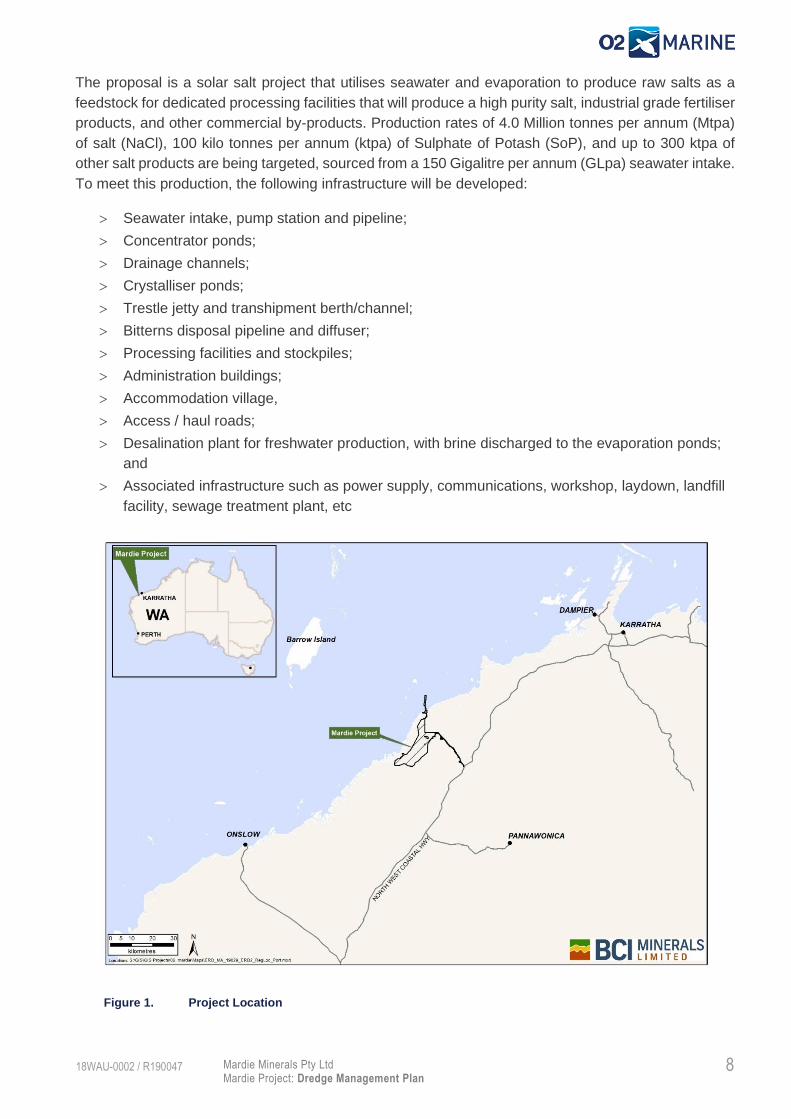
Figure 10 shows calculated Zones of Impact for offshore dredging in Sequence 6 and Sequence 7. Left
image: Offshore dredging location. Middle Image: Modelled dredge plume impact ZoMI and ZoHI for
offshore sections based on upper limit production rate (2,500m3/day). Right image: Adopted ZoMI and
ZoHI extents are shown as polygons based on adopting a minimum distance from edge of channel.
ZoHI is 25m from channel, ZoMI is 150m from channel. Actual modelled results are shown spatially
contained within the respective bounds.
Figure 10. Calculated zones of impact for offshore dredging in Sequence 6 and Sequence 7 (Baird 2020b).

28 Mardie Minerals Pty Ltd Mardie Project: Dredge Management Plan
18WAU-0002 / R190047
Figure 11. Calculated overall Zones of Impact (ZoMI and ZoHI) for best and worst case scenarios (Baird, 2020b)
Onshore Spoil Disposal
Dredge material will be unloaded from the loader barges at the shoreline and transported to a pre-
determined spoil disposal area, where the spoil will be utilised to construct land-based components for
the project (including bunds and pads, windrows, transit routes and ramps etc).

29 Mardie Minerals Pty Ltd Mardie Project: Dredge Management Plan
18WAU-0002 / R190047
4. Roles and Responsibilities
Table 5. Project Roles and Responsibilities
Position Responsibility
Proponent (as Principal) • Overall responsibility for implementation of this DMP.
• Overall responsibility for complying with all relevant legislation, standards
and guidelines.
• Ensures dredging activities are conducted in an environment safe for both
site personnel and the public.
• Reports on environmental performance for the project to relevant DMAs
and to the Key Stakeholders.
• Responsible for the implementation of the environmental monitoring
programs and inspections.
• Prepares environmental monitoring reports.
• Responsible for environmental compliance reporting in accordance with
Ministerial Conditions (pending).
• Responsible for reporting all environmental non-compliance incidents in
accordance with Ministerial Conditions (pending).
Dredging Contractor • Prepares and implements an environmental management plan in
accordance with the requirements of this DMP.
• Implements the management actions of this DMP.
• Ensures adequate training of all staff within its area of responsibility.
• Ensures all equipment is adequately maintained and correctly operated.
• Responsible for reporting all environmental incidents to Proponent
Environmental Advisor within 24 hours in accordance with incident
reporting procedures.
All persons involved in the
project.
• Comply with the requirements of this DMP.
• Comply with all legal requirements under the approvals documents and
relevant Acts.
• Exercise a Duty of Care to the environment at all times.
• Report all environmental incidents.

30 Mardie Minerals Pty Ltd Mardie Project: Dredge Management Plan
18WAU-0002 / R190047
5. Environmental Factors and Objectives
The key environmental factors and objectives to be managed under this DMP have been derived from
the Statement of Environmental Principles, Factors and Objectives (EPA 2018), which outlines
objectives aimed at protecting all environments (Themes) including: Sea, Land, Water, Air and People
(Table 6).
Correspondence provided by the EPA, dated 13 June 2018 (case number CMS17264), outlines that of
the environmental factors relevant to the proposal, three factors under theme ‘Sea’ are of potential
significance and are relevant to the dredging scope. As a result, project specific Environmental
Protection Outcomes (EPOs) and Management Targets (MT) have been derived for these three factors:
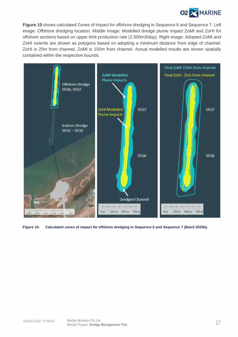
Benthic Communities and Habitats; Marine Environmental Water Quality; and Marine Fauna (Table 7).
Table 6. Factors and Objectives (EPA 2018).

31 Mardie Minerals Pty Ltd Mardie Project: Dredge Management Plan
18WAU-0002 / R190047
Table 7. Potential Environmental Impacts, Environmental Protection Outcomes and Management Targets for Mardie Project.
Environmental
Factor
EPA Objective Potential
Environmental Impact
Pathway
Environmental
Protection Outcome
(EPO)
Management Target Management
Measures
Benthic Communities
and Habitats
To protect BCH so
that biological
diversity and
ecological integrity
are maintained.
• Direct loss of BCH
through dredging (capital
and maintenance).
• No irreversible loss of BCH
outside of the worst-case
ZoHI. Refer to Figure 11
• No irreversible loss of BCH outside
of the best-case ZoHI. Refer to
Figure 11
Table 8
• Indirect impacts on BCH
associated with changes
to water quality
(increased suspended
sediment and/or
sedimentation).
• No irreversible loss of BCH
outside of the worst-case
ZoHI. Refer to Figure 11
• No negative change from the
baseline state of BCH outside
of the worst-case ZoHI and
ZoMI. Refer to Figure 11
• No negative change from the
baseline state of BCH outside of the
best-case ZoHI and ZoMI Figure 11.
• Indirect impacts on BCH
associated with leaks or
spills of hydrocarbons or
chemicals.
• No irreversible loss, or
serious damage to BCH
outside of the worst-case
ZoHI. Refer to Figure
11Figure 11Error!
Reference source not found.
• Manage vessel bunkering, chemical
storage and spill response to
minimise impacts to the marine
environment.
• Indirect impact to BCH
health due to Introduced
Marine Pests (IMP).
• No irreversible loss, or
serious damage to BCH
resulting from IMP introduced
through project vessels.
• Manage project vessels activities to
prevent IMP impacts on the
environment.
Marine
Environmental
Quality
To maintain the
quality of water,
sediment and biota so
that environmental
values are protected.
• Contamination of water
resulting from a
vessel/hydrocarbon spill
(i.e. bunkering
operations).
• N/A. • Manage vessel bunkering, chemical
storage and spill response to
minimise impacts to the marine
environment.
Table 9
32 Mardie Minerals Pty Ltd Mardie Project: Dredge Management Plan
18WAU-0002 / R190047
Environmental
Factor
EPA Objective Potential
Environmental Impact
Pathway
Environmental
Protection Outcome
(EPO)
Management Target Management
Measures
• Disturbance of
contaminants and
Potential Acid Sulphate
Soils (PASS) during
marine construction
activities (dredging).
• N/A. • Assess and manage marine
sediment PASS to maintain the
quality the marine and land
environment.
Marine Fauna To protect marine
fauna so that
biological diversity
and ecological
integrity are
maintained.
• Disturbance, Injury or
death of marine fauna as
a result of dredge
operations.
• N/A. • Manage dredge operations so no
injury or death of marine fauna
occurs.
Table 10
• Injury or death of marine
fauna due to vessel
movement (strike).
• Manage vessel speed so no injury or
death of marine fauna occurs as a
result of vessel strike.
• Indirect impacts on
marine fauna habitat
through decreased water
quality.
• Manage dredge activities to
minimise turbid plumes as to not
impact marine fauna habitats.
• Disturbance, Injury or
death from contaminated
water from hydrocarbon
spills.
• Manage vessel bunkering, chemical
storage and spill response to
minimise impacts to marine fauna.
• Introduced Marine Pests
(IMP) translocation from
construction or
operational vessels.
• All relevant vessels to comply with
Commonwealth Department of
Agriculture and Water Resources –
Australian Ballast Water
Management Requirements.

33 Mardie Minerals Pty Ltd Mardie Project: Dredge Management Plan
18WAU-0002 / R190047
6. Management
The potential environmental impacts identified above in Table 7, have been assigned monitoring and management actions to measure compliance
against the EPOs1 and MT. Management measures for each environmental factor (EPA, 2018) are detailed below.
Benthic Communities and habitats
Management proposed to minimise potential impacts on the environmental factor ‘Benthic Communities and Habitat’ are described in Table 8.
Table 8. Management actions to minimise impacts on Benthic Community Habitats
Environmental Factor Benthic Communities and Habitats
Activity Capital Dredging and Maintenance Dredging
Potential Impacts • Direct loss of BCH through dredging (capital and maintenance).
• Indirect impacts on BCH associated with changes to water quality (increased suspended sediment and/or sedimentation).
• Indirect impacts on BCH associated with leaks or spills of hydrocarbons or chemicals.
• Indirect impact to BCH health due to Introduced Marine Pests (IMP).
Management
Targets
Management Actions Environmental Performance
Item Actions Responsibility Reporting/Evidence Timing Contingency
No irreversible loss of BCH outside of the best-case ZoHI.
6.1 • Undertake a HAZID risk assessment with all parties to ensure potential impacts on
• Proponent / Contractor
• Minutes of HAZID
• Prior to commencement of dredging.
• N/A - Completed
1 EPOs identified in Table 7 are not presented in the following tables as it is assumed that if the MT is achieved then the corresponding EPO will also be achieved.

34 Mardie Minerals Pty Ltd Mardie Project: Dredge Management Plan
18WAU-0002 / R190047
Management
Targets
Management Actions Environmental Performance
Item Actions Responsibility Reporting/Evidence Timing Contingency
BCH are known and understood.
6.2 • Utilise a satellite-based vessel monitoring system on dredge vessel to ensure no works outside the approved disturbance area.
• Contractor • Inspection of satellite-based vessel monitoring system.
• Daily dredge logs submitted to the proponent throughout construction.
• Prior to and during dredge operations.
• Weekly throughout construction
• Cessation of dredging activities; and
• Maintenance of tracking system.
No negative change from the baseline state of BCH outside of the best-case ZoHI and ZoMI
6.3 • Monitor dredge operations (duration, intensity, overflow rates etc) to minimise and control SSC where possible.
• Contractor • Daily dredge logs submitted to the proponent throughout construction.
• Weekly throughout construction
• Modify or cease dredging activities if required.
6.4 • Implement Benthic Habitat Montioring Program (BHMP) as per Section 7.2
• Contractor • BCH Assessment Report including data (photographs)
• Quarterly during baseline period (12 months)
• Reactive during dredging, following level 3 management trigger.
• Within 12 months following completion of dredging.
• Determine source of impact and modify dredge operations if required.
• If impacts are detected, then continue monitoring on an annual basis for up to 5 years post-dredging to monitor recovery.
6.5 • Implement the Marine Water Quality Monitoring Program (MWQMP), refer Section 7.1
• Contractor/ Proponent • Telemetered Water Quality Data (i.e. NTU)
• Water Quality Report
• Data recorded hourly provided daily.
• Monthly
• Determine source of impact and modify dredge operations if required.
6.6 • Undertake plume validation monitoring with Aerial Multisectoral Imagery
• Proponent • Plume Validation Report
• At Start of Dredging.
• Quarterly during dredging, and
• Investigate other data sources to validate plume model (e.g. MODIS imagery).

35 Mardie Minerals Pty Ltd Mardie Project: Dredge Management Plan
18WAU-0002 / R190047
Management
Targets
Management Actions Environmental Performance
Item Actions Responsibility Reporting/Evidence Timing Contingency
• Following a Level 2 management trigger (Table 13)
Manage vessel bunkering, chemical storage and spill response to minimise impacts to the marine environment.
6.7 • Develop and implement project specific management procedures:
• Chemical Storage and Handling Procedure.
• Vessel Bunkering Procedure.
• Shipboard Oil Pollution Emergency Plan (SOPEP).
• Contractor • Approved Management Procedures/Plans
• Prior to commencement of work.
• Develop and implement management procedures
• Update procedures where necessary.
6.8 • All project vessels to maintain adequate spill response equipment on board.
• All crew to be trained in emergency spill response.
• Contractor • Pre work inspection
• Monthly Inspections
• Crew training logs
• Prior to commencement of works
• Monthly during dredge operations
• Refresh training regularly throughout project
• Source spill response equipment.
• Train all vessel crew.
Manage project vessels activities to prevent IMP impacts on the environment.
6.9 • All relevant vessels should comply with Commonwealth Department of Agriculture and Water Resources – Australian Ballast Water Management Requirements, the National Biofouling Management
• Contractor • Vessel management procedures.
• Prior to vessel entering Australian Waters or moving from one Australian port to the project site.
• Vessel are not to mobilise to project site without approved IMP documentation.

36 Mardie Minerals Pty Ltd Mardie Project: Dredge Management Plan
18WAU-0002 / R190047
Management
Targets
Management Actions Environmental Performance
Item Actions Responsibility Reporting/Evidence Timing Contingency
Guidelines for commercial vessels.
6.10 • All vessels that mobilise to the project site are required to complete the WA Department of Fisheries (DoF’s) ‘Vessel Check’ risk assessment (https://vesselcheck.fish.wa.gov.au)
• Contractor • A copy of the Vessel Check report is to be submitted to PPA for assessment along with any supporting documentation including antifoul certificates and inspection reports.
• Prior to dredge entering Australian Waters or moving from one Australian port to the project site.
• Vessel are not to mobilise to project site without approved IMP documentation.

37 Mardie Minerals Pty Ltd Mardie Project: Dredge Management Plan
18WAU-0002 / R190047
Marine Environmental Quality
Management proposed to minimise potential impacts on the environmental factor ‘Marine Environmental Quality’ are described in Table 9.
Table 9. Management actions to minimise impacts on Marine Environmental Quality
Environmental Factor Marine Environmental Quality
Activity Capital Dredging and Maintenance Dredging
Potential Impacts • Contamination of water resulting from a vessel/hydrocarbon spill (i.e. bunkering operations).
• Disturbance of contaminants and Potential Acid Sulphate Soils (PASS) during marine construction activities (dredging).
Management
Targets
Management Actions Environmental Performance
Item Actions Responsibility Reporting/Evidence Timing Contingency
Manage vessel bunkering, chemical storage and spill response to minimise impacts to the marine environment
7.1 • Develop and implement project specific management procedures:
• Chemical Storage and Handling Procedure.
• Bunkering Procedure.
• 3. Shipboard Oil Pollution Emergency Plan (SOPEP).
• Contractor • Approved Management Procedures
• Prior to commencement of work.
• Develop and implement management procedures
• Update procedures where necessary.
7.2 • All vessel equipment to be designed and operated to prevent spills and leaks through the provision of in-built safeguards such as,
• Contractor • Monthly Inspections
• Vessel management procedure
• Monthly • Rectify any equipment that is damaged or missing as soon as practicable.
• Dredge operations not to commence prior to
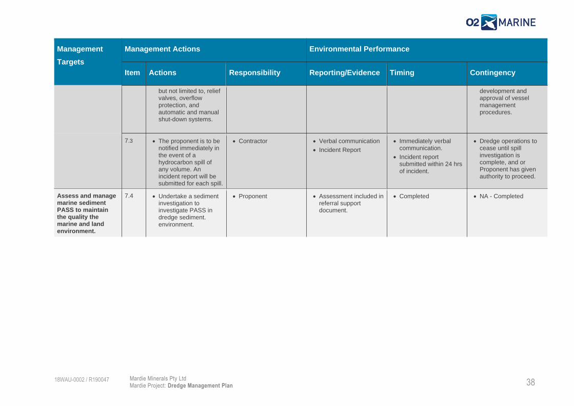
38 Mardie Minerals Pty Ltd Mardie Project: Dredge Management Plan
18WAU-0002 / R190047
Management
Targets
Management Actions Environmental Performance
Item Actions Responsibility Reporting/Evidence Timing Contingency
but not limited to, relief valves, overflow protection, and automatic and manual shut-down systems.
development and approval of vessel management procedures.
7.3 • The proponent is to be notified immediately in the event of a hydrocarbon spill of any volume. An incident report will be submitted for each spill.
• Contractor • Verbal communication
• Incident Report
• Immediately verbal communication.
• Incident report submitted within 24 hrs of incident.
• Dredge operations to cease until spill investigation is complete, and or Proponent has given authority to proceed.
Assess and manage marine sediment PASS to maintain the quality the marine and land environment.
7.4 • Undertake a sediment investigation to investigate PASS in dredge sediment. environment.
• Proponent • Assessment included in referral support document.
• Completed • NA - Completed

39 Mardie Minerals Pty Ltd Mardie Project: Dredge Management Plan
18WAU-0002 / R190047
Marine Fauna
Management proposed to minimise potential impacts on the environmental factor ‘Marine Environmental Quality’ are described in Table 10.
Table 10. Management actions to minimise impacts on Marine Fauna
Environmental Factor Marine Fauna
Activity Capital Dredging and Maintenance Dredging
Potential Impacts • Disturbance, Injury or death of marine fauna as a result of dredge operations.
• Injury or death of marine fauna due to vessel movement (strike).
• Indirect impacts on marine fauna habitat through decreased water quality.
• Disturbance, Injury or death from contaminated water from hydrocarbon spills.
• Introduced Marine Pests (IMP) translocation from construction or operational vessels.
Management
Targets
Management Actions Environmental Performance
Item Actions Responsibility Reporting/Evidence Timing Contingency
Manage dredge operations so no injury or death of marine fauna occurs.
8.1 • Implement a soft start procedure prior to activating below surface operations.
• Contractor • Daily dredge logs. • Each occasion, prior to activating cutter head.
• Dredge operations not to commence unless a soft start procedure has been implemented.
8.2 • All project vessels are to have at least one crew member trained as a Marine Fauna Observer (MFO) on board at all times.
• Contractor • Training certificate. • Prior to commencement of dredging.
• Dredge operations not to commence unless at least one crew member is a trained MFO.
8.3 • MFO logs to be complete during all dredge operations.
• Contractor • MFO logs.
• Monthly Environmental Monitoring Report.
• Daily whilst dredge operations are occurring.
• Reported monthly.
• Investigate why MFO logs were not complete, and ensure adequate staff and

40 Mardie Minerals Pty Ltd Mardie Project: Dredge Management Plan
18WAU-0002 / R190047
Management
Targets
Management Actions Environmental Performance
Item Actions Responsibility Reporting/Evidence Timing Contingency
resources are in place to fulfil requirement.
8.4 • Dredge operations are to cease if:
o Whales or dugongs are observed within 100 m of the dredge vessel.
o Dolphins, sawfish or turtles are observed and at risk within 50 m of the dredge vessel.
• Contractor • MFO logs,
• Daily dredge logs.
• For the duration of dredging.
• Investigate why dredge operations were not ceased and apply required correction actions.
8.5 • Report any injured or deceased marine mega fauna (whale, dugong, sawfish, turtle or dolphin) on the project site to the Proponent.
• Contractor • Verbal/written communication
• Incident Report
• Immediately upon observation
• Within 72 hours of incident
• Investigate fauna death and apply required corrective actions and or modifications to dredge operations.
Manage vessel speed so no injury or death of marine fauna occurs as a result of vessel strike.
8.6 • All construction vessels to operate at a safe speed as to avoid interaction with marine fauna at all times within project boundaries.
• Contractor • Vessel GPS monitoring system
• Continuous throughout vessel operations.
• Investigate why vessel was recorded in excess for the defined speed limit and amend vessel operations and activities as appropriate.
8.7 • All project vessels are to have at least one crew member trained as an MFO on board at all times.
• Contractor • Training certificate. • Prior to commencement of dredging.
• Crew to undertake MFO training

41 Mardie Minerals Pty Ltd Mardie Project: Dredge Management Plan
18WAU-0002 / R190047
Management
Targets
Management Actions Environmental Performance
Item Actions Responsibility Reporting/Evidence Timing Contingency
Manage dredge activities to minimise turbid plumes as to not impact marine fauna habitats.
8.8 • Implement the Marine Water Quality Monitoring Program (MWQMP), refer Section 7.1
• Contractor/ Proponent • Telemetered Water Quality Data (NTU)
• Water Quality Report
• Data recorded hourly provided daily.
• Monthly
• Determine source of impact and modify dredge operations if required.
Manage vessel bunkering, chemical storage and spill response to minimise impacts to marine fauna
8.9 • Develop and implement project specific management procedures:
o Chemical Storage and Handling Procedure.
o Bunkering Procedure.
o Shipboard Oil Pollution Emergency Plan (SOPEP).
• Contractor • Approved Management Procedures
• Prior to commencement of work.
• Develop and implement management procedures
• Update procedures where necessary.
8.10 • All vessel equipment to be designed and operated to prevent spills and leaks through the provision of in-built safeguards such as, but not limited to, relief valves, overflow protection, and automatic and manual shut-down systems.
• Contractor • Vessel management procedure
• Monthly Inspections
• Prior to commencing dredging.
• Monthly
• Rectify any equipment that is damaged or missing as soon as practicable.
• Dredge operations not to commence prior to development and approval of vessel management procedures.
8.11 • The proponent is to be notified immediately in the event of a hydrocarbon spill of any volume. An incident report will be submitted for each spill.
• Contractor • Verbal communication
• Incident Report
• Immediately verbal communication.
• Incident report submitted with 24 hrs of incident.
• Dredge operations to cease until spill investigation is complete, and or Proponent has given authority to proceed.

42 Mardie Minerals Pty Ltd Mardie Project: Dredge Management Plan
18WAU-0002 / R190047
Management
Targets
Management Actions Environmental Performance
Item Actions Responsibility Reporting/Evidence Timing Contingency
All relevant vessels to comply with Commonwealth Department of Agriculture and Water Resources – Australian Ballast Water Management Requirements.
8.12 • All relevant vessels should comply with Commonwealth Department of Agriculture and Water Resources – Australian Ballast Water Management Requirements, the National Biofouling Management Guidelines for commercial vessels.
• Contractor • Vessel management procedures.
• Prior to vessel entering Australian Waters or moving from one Australian port to the project site.
• Vessel are not to mobilise to site without approved IMP documentation.
8.13 • All vessels that mobilise to the project site are required to complete the WA DoF’s ‘Vessel Check’ risk assessment (https://vesselcheck.fish.wa.gov.au)
• Contractor • A copy of the Vessel Check report is to be submitted to PPA for assessment along with any supporting documentation including antifoul certificates and inspection reports.
• Prior to dredge entering Australian Waters or moving from one Australian port to the project site.
• Vessel are not to mobilise to project site without approved IMP documentation.

43 Mardie Minerals Pty Ltd Mardie Project: Dredge Management Plan
18WAU-0002 / R190047
7. Environmental Monitoring
Marine Water Quality Monitoring Program
7.1.1. Monitoring Rationale
The Marine Water Quality Monitoring Program (MWQMP) is to be implemented to ensure the EPOs for
Benthic Community Habitats, Marine Environmental Quality and Marine Fauna are met.
Marine dredging activities have the potential to increase suspended sediment and sedimentation in
marine waters. This change in water quality has potential to indirectly impact BCH by reducing light
penetration through the water column and smothering of biota due to sedimentation.
To assist the design of the MWQMP and to select suitable monitoring locations, a validated
hydrodynamic model undertaken at the project area by BCIM (Baird 2020) was used to model sediment
plumes generated by dredge operations within the proposed dredge footprint. A brief presentation of
the model results is presented in Section 3.6 and full report is provided in Appendix B.
The proposed dredge footprint consist of two key zones, the offshore (Shipping channel) and the
nearshore (marine precinct, berth pocket), hereinafter referred to respectively as Zone A and Zone B
(Figure 12).
The model result show that the dredge plume impacts are most pronounced with dredging occurring at
the nearshore (Zone A), which is associated with dredging large volumes of material over a
comparatively small spatial area with a high proportion of fine content in the sediment. For the offshore
section of the channel (Zone B), the dredging requirements are spread out over a much larger area and
the dredge plumes impacts significantly less due to sediments possessing a much high grain size and
quicker settling rate (Baird 2020). Moreover, the model shows a preferential plume direction along a
north-east to south-west axis, with dredge plume impacts elongated to the southwest driven by the
stronger flood tides in comparison to ebb tide.
The MWQMP was developed with the assumption that dredging will be undertaken sequentially through
Zone A and Zone B (i.e. two separate monitoring phases): Phase 1 monitoring will be undertaken during
the dredging of Zone A and phase 2 monitoring during the dredging of Zone B.
The proposed monitoring locations have been selected based on the predicted plume distribution for
Zone A and Zone B and aligned along the predicted plume direction north-east to south-west axis. The
location of each site will be moved to optimise the monitoring during phase 1 and phase 2 as shown in
Figure 13 and Figure 14.

44 Mardie Minerals Pty Ltd Mardie Project: Dredge Management Plan
18WAU-0002 / R190047
Figure 12. Proposed Dredging footprint of Dredge Zones A and B.

45 Mardie Minerals Pty Ltd Mardie Project: Dredge Management Plan
18WAU-0002 / R190047
7.1.2. Predicted Zone of Impact and Thresholds
The model was used to develop “best-case” and “worst-case” zonation for each of the two key dredging
zones (A and B), refer Figure 13 and Figure 14. The best-case and worst case were derived using
WAMSI threshold limit for Suspended Sediment Concentration (SSC) derived for corals (Fisher et. al.
2019) as shown in Table 11 and Figure 11. The modelled SSCs were assessed against a combination
of the 7, 14 and 28-day thresholds, which were applied across the model domain throughout the
construction period. This resulted in the definition of likely best and worst-case Zones of High Impact
(ZoHI) (irreversible loss) and Zone of Moderate Impact (ZoMI) (recoverable impact).
While the WAMSI threshold are considered appropriate to develop the modelled suspended sediment
concentration to define the different zones of potential impact for dredging, these thresholds have been
developed in an off-shore low turbidity environment and therefore are not considered to be suitable to
be used as trigger thresholds for a dredging program in a inshore environment with high turbidity levels
such as the Mardie Project. Therefore, to monitor the effects of dredging activities of the project and to
trigger management actions, project specific threshold for SSC will be derived relative to turbidity (NTU)
baseline conditions of the project area.
Prior the commencement of dredging, a site-specific calibration of SSC vs Turbidity (NTU) with an R2
>0.5 shall be derived. The site-specific nature of calibrations has been emphasised by a number of
previous studies including Fisher et. al. (2019), Sternberg et. Al. (1986,1991) and today many of the
best practice guidelines for the analysis of suspended sediment state the need for site specific
calibrations, see for example Judd (2012).
The calibration coefficient will be applied to the real time NTU data allowing post conversion to SSC
and monitoring of established triggers.
Trigger values for monitoring will be derived in accordance with the WAMSI recommendation for coral
monitoring using 12 months of baseline data which will be collected within 24 months prior the
commencement of the dredging.
Table 11. Threshold Limits for Modelled Suspended Sediment Concentration used to define ZoMI and ZoHI
regions through the dredge program (from Fisher et. al., 2019)
Threshold Running Mean Period ZoMI Threshold (>SSC) ZoHI Threshold (>SSC)
Running Mean
(SSC)
7 day 14.7 mg/l 24.5 mg/l
14 day 11.7 mg/l 18.0 mg/l
28 day 9.3 mg/l 13.2 mg/l
7.1.3. Telemetered In-situ Water Quality Monitoring.
Telemetered In-situ instruments will be installed to provide continuous one-hour interval water quality
data throughout the dredge program. This data will be transmitted to an online data portal, to enable
live updates allowing responsive monitoring and management. Each water quality sensor will be
weighted to the seabed and positioned approximately 0.5m above the seabed. Each station will be
tethered to a special designed telemetry marker boy (with navigation lighting) containing a battery and
3G/satellite telemetry components. Monitoring stations will be designed to be relocated as required
based on dredge location.
46 Mardie Minerals Pty Ltd Mardie Project: Dredge Management Plan
18WAU-0002 / R190047
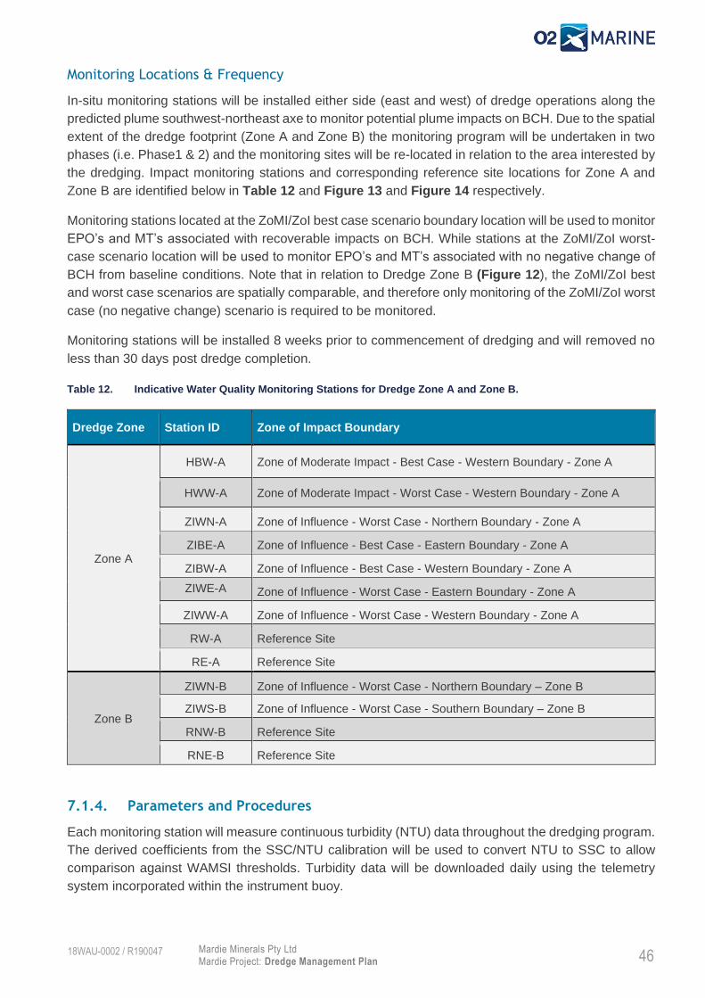
Monitoring Locations & Frequency
In-situ monitoring stations will be installed either side (east and west) of dredge operations along the
predicted plume southwest-northeast axe to monitor potential plume impacts on BCH. Due to the spatial
extent of the dredge footprint (Zone A and Zone B) the monitoring program will be undertaken in two
phases (i.e. Phase1 & 2) and the monitoring sites will be re-located in relation to the area interested by
the dredging. Impact monitoring stations and corresponding reference site locations for Zone A and
Zone B are identified below in Table 12 and Figure 13 and Figure 14 respectively.
Monitoring stations located at the ZoMI/ZoI best case scenario boundary location will be used to monitor
EPO’s and MT’s associated with recoverable impacts on BCH. While stations at the ZoMI/ZoI worst-
case scenario location will be used to monitor EPO’s and MT’s associated with no negative change of
BCH from baseline conditions. Note that in relation to Dredge Zone B (Figure 12), the ZoMI/ZoI best
and worst case scenarios are spatially comparable, and therefore only monitoring of the ZoMI/ZoI worst
case (no negative change) scenario is required to be monitored.
Monitoring stations will be installed 8 weeks prior to commencement of dredging and will removed no
less than 30 days post dredge completion.
Table 12. Indicative Water Quality Monitoring Stations for Dredge Zone A and Zone B.
Dredge Zone Station ID Zone of Impact Boundary
Zone A
HBW-A Zone of Moderate Impact - Best Case - Western Boundary - Zone A
HWW-A Zone of Moderate Impact - Worst Case - Western Boundary - Zone A
ZIWN-A Zone of Influence - Worst Case - Northern Boundary - Zone A
ZIBE-A Zone of Influence - Best Case - Eastern Boundary - Zone A
ZIBW-A Zone of Influence - Best Case - Western Boundary - Zone A
ZIWE-A
Zone of Influence - Worst Case - Eastern Boundary - Zone A
ZIWW-A Zone of Influence - Worst Case - Western Boundary - Zone A
RW-A Reference Site
RE-A Reference Site
Zone B
ZIWN-B Zone of Influence - Worst Case - Northern Boundary – Zone B
ZIWS-B Zone of Influence - Worst Case - Southern Boundary – Zone B
RNW-B Reference Site
RNE-B Reference Site
7.1.4. Parameters and Procedures
Each monitoring station will measure continuous turbidity (NTU) data throughout the dredging program.
The derived coefficients from the SSC/NTU calibration will be used to convert NTU to SSC to allow
comparison against WAMSI thresholds. Turbidity data will be downloaded daily using the telemetry
system incorporated within the instrument buoy.

47 Mardie Minerals Pty Ltd Mardie Project: Dredge Management Plan
18WAU-0002 / R190047
Turbidity sensors will be calibrated during regular maintenance and in accordance with manufacturer
specifications to ensure accurate datasets are acquired.
7.1.5. Data analysis
The likelihood of a link between dredging and water quality decline will be assessed in terms of the
following factors:
• Correct instrument function and operation;
• Locations of and status of dredging activities in relation to the site(s) at the time of the
exceedance;
• Hydrodynamic conditions, for example wind, tide, wave and swell state at the time of the
exceedance; and
• Assessment against background conditions (reference site) and extreme weather events
in the region.

48 Mardie Minerals Pty Ltd Mardie Project: Dredge Management Plan
18WAU-0002 / R190047
Table 13. Environmental Protection Outcomes, Management Targets and Management Criteria for protection of BCH from dredging in Zone A & Zone B.
Sites Early Warning
(Level 1)
Management Target
(level 2)
Environmental Protection Outcome
(Level 3)
Zone of High Impact / Zone of Moderate Impact Boundary
HBW-A Not Applicable Rolling mean daily# NTU for either 7, 14 or 28 days to
remain below the 95th percentile of seasonal baseline
data for the same period.
AND
Median daily NTU to remain below the 95th percentile
of reference site data for the same period.
Not Applicable
OR
Rolling mean DLI for either 7, 14 or 28 days to remain
above the 5th percentile of seasonal baseline data for
the same period.
AND
Median DLI to remain above the 5th percentile of
reference site data for the same period.
HWW-A Not Applicable Not Applicable Rolling mean daily# NTU for either 7, 14 or 28 days to
remain below the 95th percentile of seasonal baseline
data for the same period.
AND
Median daily NTU to remain below the 95th percentile
of reference site data for the same period.
OR
Rolling mean DLI for either 7, 14 or 28 days to remain
above the 5th percentile of seasonal baseline data for
the same period.
AND
Median DLI to remain above the 5th percentile of
reference site data for the same period.

49 Mardie Minerals Pty Ltd Mardie Project: Dredge Management Plan
18WAU-0002 / R190047
Sites Early Warning
(Level 1)
Management Target
(level 2)
Environmental Protection Outcome
(Level 3)
Zone of Moderate Impact / Zone of Influence Boundary
ZIWN-A
ZIWN-B
ZIWS-B
Not Applicable Rolling mean daily# NTU for either 3, 10 or 21 days to
remain below the 80th percentile of seasonal baseline
data for the same period.
AND
Median daily NTU to remain below the 80th percentile
of reference site data for the same period.
Rolling mean daily# NTU for either 7, 14 or 28 days to
remain below the 80th percentile of seasonal baseline
data for the same period.
AND
Median daily NTU to remain below the 80th percentile
of reference site data for the same period.
OR OR
Rolling mean DLI for either 3, 10 or 21 days to remain
above the 20th percentile of seasonal baseline data
for the same period.
AND
Median daily DLI to remain above the 20th percentile
of reference site data for the same period.
Rolling mean DLI for either 7, 14 or 28 days to remain
above the 20th percentile of seasonal baseline data
for the same period.
AND
Median daily DLI to remain above the 20th percentile
of reference site data for the same period.
ZIBE-A
ZIBW-A
Rolling mean daily# NTU for either 3, 10 or 21 days
to remain below the 80th percentile of seasonal
baseline data for the same period.
AND
Median daily NTU to remain below the 80th
percentile of reference site data for the same period.
Rolling mean daily# NTU for either 7, 14 or 28 days to
remain below the 80th percentile of seasonal baseline
data for the same period.
AND
Median daily NTU to remain below the 80th percentile
of reference site data for the same period.
Not Applicable
OR OR
Rolling mean DLI for either 3, 10 or 21 days to
remain above the 20th percentile of seasonal
baseline data for the same period.
AND
Median daily DLI to remain above the 20th percentile
of reference site data for the same period.
Rolling mean DLI for either 7, 14 or 28 days to remain
above the 20th percentile of seasonal baseline data
for the same period.
AND
Median daily DLI to remain above the 20th percentile
of reference site data for the same period.
ZIWE-A
ZIWW-A
Not Applicable Not Applicable Rolling mean daily# NTU for either 7, 14 or 28 days to
remain below the 80th percentile of seasonal baseline
data for the same period.
AND

50 Mardie Minerals Pty Ltd Mardie Project: Dredge Management Plan
18WAU-0002 / R190047
Sites Early Warning
(Level 1)
Management Target
(level 2)
Environmental Protection Outcome
(Level 3)
Median daily NTU to remain below the 80th percentile
of reference site data for the same period.
OR
Rolling mean DLI for either 7, 14 or 28 days to remain
above the 20th percentile of seasonal baseline data
for the same period.
AND
Median daily DLI to remain above the 20th percentile
of reference site data for the same period.
*Baseline seasonal (i.e. Summer, Winter & Transitional) percentile values (i.e. 5th, 20th, 80th & 95th) will be derived from rolling mean values for 7, 14, & 28-day periods for each
season. Baseline data to be collected in the vicinity of the dredging area for at least 12-months prior to dredging.
# Rolling mean daily NTU is to be calculated once per day.

51 Mardie Minerals Pty Ltd Mardie Project: Dredge Management Plan
18WAU-0002 / R190047
Figure 13. Dredge Zone A – Indicative Water Quality Monitoring Locations

52 Mardie Minerals Pty Ltd Mardie Project: Dredge Management Plan
18WAU-0002 / R190047
Figure 14 Dredge Zone B – Indicative Water Quality Monitoring Locations

53 Mardie Minerals Pty Ltd Mardie Project: Dredge Management Plan
18WAU-0002 / R190047
7.1.6. Tiered Management Framework
A Tiered Management Framework (TMF) has been developed based on monitoring and reporting
against the three trigger levels to ensure EPOs and MTs for protection of BCH are achieved during
dredging. The TMF presented in (Figure 15) will be implemented by the Proponent/Contractor.
7.1.7. Recommencement Criteria
In the event that dredging is ceased as a result of failure to achieve the nominated water quality
criteria (i.e. Management Action Level 3), then an Interim Reactive BCH Survey should be
undertaken to evaluate the extent of impact (if any) to BCH arising from the dredging activities. In
this instance, dredging may only recommence under the following circumstances:
Interim reactive BCH survey confirms that no impact to BCH has occurred as a result of dredging
activities;
BCH impacts have been confirmed and reported to DWER. DWER subsequently advise that
dredging in the affected area can continue under certain conditions; OR
Dredging can be undertaken in other unaffected areas without impacting on BCH. Monitoring as per

54 Mardie Minerals Pty Ltd Mardie Project: Dredge Management Plan
18WAU-0002 / R190047
Figure 15. Tiered Management Framework for Marine Water Quality Monitoring

55 Mardie Minerals Pty Ltd Mardie Project: Dredge Management Plan
18WAU-0002 / R190047
7.1.8. Aerial Plume Validation
Aerial multispectral imagery will be used to quantitatively assess and validate plumes models. High
spatial resolution multispectral imagery validated with real-time Total Suspended Solids (TSS) samples
will be captured via Unmanned Aerial Vehicle (UAV) at the start of dredging and on a quarterly basis
during dredge operations. This data will allow assessment of TSS levels from dredge plumes, which
are not likely to be visible via broad scale MODIS imagery due to the method of dredging and expected
small scale plumes. This data will increase the accuracy of impact assessment on BCH and will help
inform the predictive plume model. Multispectral imagery verification will also be implemented in the
event that a Level 3 Trigger exceedance is breached (Figure 15). A dredge plume validation report will
be prepared following each survey event.

56 Mardie Minerals Pty Ltd Mardie Project: Dredge Management Plan
18WAU-0002 / R190047
Benthic Habitat Monitoring Program
7.2.1. Objectives
The Benthic Habitat Monitoring Program (BHMP) together with the WQMP will aim to provide an
evaluation of the EPOs for BCH which are:
Recoverable Impacts to BCH within the Zone of Moderate Impact; and
No Negative Change to the Baseline State of BCH within the Zone of Influence.
7.2.2. Monitoring Rationale
As identified in Section 2.5, coral communities are considered to be the most vulnerable (of those BCH
present in the impact area) to the effects of increased SSC and the associated decline in benthic light
availability. Therefore, coral health has been selected as the lead indicator for monitoring of benthic
community health within the ZoMI and ZoI.
Unfortunately, percent cover of BCH in the vicinity of the dredging area is generally very low (i.e. <5%)
and the proportion of coral within this community is expected to be extremely low (i.e. <1%). Therefore,
a standard Before After Control Impact (BACI) design focussed on overall percent cover of coral is
unlikely to achieve a statistical power to determine if any observed changes can be definitively related
to dredging impacts.
Therefore, to account for the low benthic cover and to achieve a statistical power of 0.8, the BHMP will
focus on monitoring of individual (tagged) coral colonies before, during and after dredging activities at
the designated impact and control sites. The BHMP is designed to identify and measure changes in
condition of individual colonies that are attributable to dredging activities, and which are greater than
the changes occurring naturally at control sites. Additional benthic cover information will also be
collected to inform multiple lines of evidence assessment.
7.2.3. Effect Size
The EPOs and associated proposed effect size for assessment of dredging-related impacts to hard
coral BCH are:
No irreversible loss of, or serious damage to, coral habitats outside of the ZoHI;
Protection of at least 70% of baseline live coral cover (within tagged colonies) on each
designated reef formation within the ZoMI; or
No detectable reduction of net live coral cover (within tagged colonies) within the ZoI.
7.2.4. Locations
Indicative monitoring locations have been selected in areas of at least moderate benthic coral cover
and these are presented in Figure 16 and include:
• Three (3) locations within the ZoMI (ZM1, ZM2, and ZM3) to assess recoverable impacts; and
• Three (3) locations within the ZoI (ZI1, ZI2, and ZI3) to assess no change from baseline state.
A further three (3) reference monitoring locations are required to be determined as suitable control
locations. No monitoring is proposed within the ZoHI.

57 Mardie Minerals Pty Ltd Mardie Project: Dredge Management Plan
18WAU-0002 / R190047
Figure 16. Indicative BCH Monitoring Locations.

58 Mardie Minerals Pty Ltd Mardie Project: Dredge Management Plan
18WAU-0002 / R190047
7.2.5. Frequency
Baseline Surveys
BCH surveys to establish baseline condition should be undertaken quarterly and commence at least 12
months prior to commencement of dredging.
During Dredging (Reactive) Surveys
During dredging, BCH surveys are only required in the event that a level 3 management event (i.e. NTU
or DLI EPO Trigger as defined in Table 13) is triggered.
Post-Dredging Survey
One post-dredging survey should be undertaken within 12 months following completion of dredging to
evaluate status of EPOs within the ZOMI and the ZOI. Where dredging impacts are detected in areas
outside of the ZOHI, then post-dredging BCH surveys should continue, on at least an annual basis, for
up to 5 years, or until BCH that is impacted as a result of dredging is considered to have recovered to
a pre-dredging (baseline) condition.
7.2.6. Survey Methods
Individual Colonies
At each site, a total of 80 colonies will be selected, across five permanent transects (i.e. 16 colonies
per transect). Colonies will be selected on the basis of an initial appraisal of condition (i.e. no obvious
signs of mortality, bleaching or excessive mucous production) and targeted between the size range
conducive to photography: 11-75 cm. Where larger colonies (<75 cm) are present, these colonies will
be divided into smaller (0.5 m) sections along the transect for separate evaluation. Where possible,
colonies will be selected from a broad range of species, representative of different family groups and
morphologies at each site, including sensitive genera (e.g. Acropora) and less sensitive genera (e.g.
Turbinaria).
Colonies will be selected from within 1 m either side of the permanent transects. Using the permanent
transect as a reference point, the locations of colonies will be recorded using bearings and offset
distances from the tape to enable re-location during subsequent surveys. Where there are limited
colonies recorded, additional colonies may be added by searching the area between 1-2 m either side
of the transect.
Sub-lethal indicators will be recorded for each colony in-situ using the classification details provided in
Table 14. Digital photographs will be collected at distances which allow the colony to maximise the field
of view on the image. A set of Coral Reference Photographs taken during the first baseline survey
showing the original image of each of the corals with the location bearings and distances from the
transect will be used to compare against each colony to ensure that the correct corals are assessed on
each sampling occasion. Colonies will be photographed from the same orientation/perspective (from
start of transect) and distance. Where an area of colony is covered in sediment, it will not be cleared
away from the colonies before photographs are taken. Where macroalgae obscure a colony, the
macroalgae will be moved to allow a clear photograph to be taken, unless the macroalgae are growing
on or within the colony and its removal would damage either the coral or the macroalgae.

59 Mardie Minerals Pty Ltd Mardie Project: Dredge Management Plan
18WAU-0002 / R190047
Table 14 In-situ classification details of sub-lethal indicators to be recorded for each colony during each survey
Indicator 1 2 3 4 5
Partial Mortality
<10% 10-30% 30-60% 60-80% >80% Sediment deposition
Coral colour paling focal bleaching non-focal bleaching
partial bleaching total bleaching
Mucous Production
Presence/absence
Disease Presence/absence & Type (i.e. White syndrome, black band, brown band, other)
Predation/Type Presence/absence & Type (i.e. Fish scars, Polychaetes, Tremetodes, other)
Line Intercept Transect
A tape measure will be run over each 20 m permanent transect, then a suitably qualified coral specialist
will identify and record benthic cover type and form located directly beneath the tape measure for each
transect. Data will be used to calculate percentage benthic cover type across the monitoring location.
7.2.7. Data Analysis
Image Analysis
Each individual coral colony image will be analysed using coral point count with excel extensions
(CPCe) to determine the extent of live coral cover for each coral colony. Sixty (60) points will be
assessed per image and coral condition (i.e. live/dead) will be recorded for each point.
The sub lethal indicators recorded in the field will be evaluated to determine the metrics shown in Table
15. The mean of the scores from the assessment of partial mortality, coral colour and sediment
deposition will be compared to the baseline record. A shift of three points on the six-point classification
(including zero) will constitute an adverse change in sub-lethal coral indicators. The incidence of
colonies exhibiting evidence of coral mortality, bleaching, mucous production, predation and disease
will be calculated by summing the number of colonies with evidence of these effects divided by the total
number of colonies. This will be expressed as a percentage reduction in coral condition from the
baseline level.
Table 15 Post-processing data for the following indicators.
Indicator Analysis Description
Partial Mortality Total mean partial mortality1 scores from CPCe
Colony mortality Proportion of colonies in Category 5
Coral colour Total mean coral colour scores1
Colony bleaching Proportion of colonies in Category 4 & 5
Sediment deposition Total mean sediment cover1 scores
Sedimentation Proportion of colonies in Category 5
Mucous production Proportion of colonies with evidence of the presence of mucous
Disease Proportion of colonies with evidence of the presence of coral disease
Acanthaster Incidence of Acanthaster species along transects
Drupella Proportion of colonies with evidence of the presence of Drupella
Predation Proportion of colonies with evidence of predation 1 All colonies included in the assessment (i.e. colonies scoring zero are included in calculating the mean)

60 Mardie Minerals Pty Ltd Mardie Project: Dredge Management Plan
18WAU-0002 / R190047
Line Intercept Transect
The percentage of benthic species cover that directly intercept the tape measure length of each 20 m
transect using the line-intercept method will be calculated into a proportion of each benthic group (i.e. 20 m
equals 100%). The benthic groups used will be calculated manually in excel to determine the relative
abundance, mean, standard deviation, standard error and the Shannon-Weaver diversity Index of each
benthic cover type at each site. Line intercept data will not be used for EPO assessment.
7.2.8. Statistical Analysis
The process for analysis of lethal and sub-lethal data and comparison against the EPOs is shown in
Table 16.
The first step of the analysis is a statistical paired-samples t-test of gross negative change in coral
colour/bleaching, partial/colony mortality and coral cover at the impact location. This uses a null
hypothesis of no difference between the impact location at time ‘x’ during dredging compared to
baseline to test the one-tailed alternative hypothesis that the negative change at the impact location is
significantly greater than the negative change at reference locations.
This is followed by a similar test, but of net negative change at the impact location (i.e. factoring in
change in cover that occurred concurrently at reference locations). Specifically, the (one-tailed)
hypothesis being tested is that difference in the negative change is greater at the impact location than
at the reference locations. The appropriate statistical test is a two-(independent)-sample t-test between
the average of the impact locations and the average of reference locations. This uses a null hypothesis
of no difference between the impact location at time ‘x’ during dredging compared to baseline to test
the one-tailed alternative hypothesis that the negative change recorded between baseline and time ‘x’
at impact locations is greater than the negative change recorded at impact locations.
The t-tests of changes within sites proposed here are equivalent to the main interaction test (before–
after × control–impact) in a standard Multiple Before–After, Control–Impact (MBACI) design (Keough
and Mapstone 1997; Downes et al. 2002; Quinn and Keough 2002). The only difference is that there
will only ever be one measurement in the “after” (during dredging) period that is being assessed, so
there is additional temporal imbalance compared to a usual MBACI design. The statistical analysis is
also based on an asymmetrical design, characterised by a before versus after contrast at multiple
control sites but only a single impact site. The impact sites for the tests may be grouped together to
form an additional balanced statistical test where three sites represent each of the impact zones and
provide greater confidence that EPOs have been achieved for the Project.
A conventional Type I error rate of 0.05 will be applied across the tests. Type II error rates of statistical
power will be determined during the baseline study.

61 Mardie Minerals Pty Ltd Mardie Project: Dredge Management Plan
18WAU-0002 / R190047
Table 16 The process for evaluation of EPOs
Name Description Objective
Average
Baseline
Calculate average measurements for each colony across
each site over multiple sampling times before dredging
To determine natural levels of change before
dredging
Gross
Change
Subtract the Average Baseline from recent dredging
survey for each colony/transect and average across each
site
To calculate the average change from
baseline to recent dredge survey at each
impact and control site
Test of Gross
Change
Paired-sample t-tests performed between baseline and
recent dredge survey averages where negative change
was recorded at impact site.
A statistically significant negative change
might provide evidence supportive of a
dredging-related impact.
Test of Net
Change
Two-(independent)-sample t-test performed to compare
negative changes between impact and control sites where
negative change was recorded at impact site.
A statistically significant negative change
might provide evidence supportive of a
dredging-related impact.
Multiple Lines
of Evidence
Detailed interrogation of all data collected using
supportive univariate and multivariate analyses where
Test of Net Change is exceeded
To rigorously assess whether the detected
change at an affected reef was due to
dredging or simply the result of natural
change
Multiple Lines of Evidence
In the event that management criteria are exceeded, a series of investigations and statistical analyses
will be initiated in a structured decision-making framework to rigorously assess whether the detected
change at an affected reef was due to dredging or simply the result of natural change.
The first step will be an assessment of the magnitude of change (effect size and its confidence interval)
in coral cover for the individual colonies between the impact and reference locations, from before
dredging to the current survey period (that is, whether the difference in coral cover between the affected
reef and the control reefs had increased or remained consistent since dredging). The purpose of this
method is to compare the effect size during baseline with the effect size after dredging. A confidence
interval approach provides important information for decision-making not gained from a test of a null
hypothesis and focuses on the magnitude of change, with some measure of uncertainty. A larger mean
effect size (+- CI) following dredging may provide evidence supportive of the dredge impact hypothesis.
A comparison of trends in mean coral cover through time will then be compared among the impact and
reference locations. Evidence supportive of the dredge impact hypothesis would be a decline in cover
at the impact location following dredging, but no corresponding decline at the reference location.
An inference assessment will then be undertaken, which includes the collation and synthesis of all
available circumstantial evidence supporting or refuting the conclusion that either dredging or a natural
agent of disturbance resulted in an observed decline in coral cover at the impacted location.
Multiple lines of evidence, based on causal indicators, are used to assess the impact hypothesis and
may apply a variety of univariate or multivariate analysis. With lines of evidence there is a need to seek
evidence not only to support the impact prediction, but evidence to rule out plausible alternative
predictions, such as that the observed difference was due to natural processes (Beyers 1998; Downes
et al. 2002). Potential natural or other anthropogenic causes of impact within the Project area may
include thermal bleaching from warm water temperatures, natural mortality, pollution, predation,
cyclonic events, salinity change and anthropogenic causes for elevated turbidity (e.g. ship propeller
disturbance, maintenance dredging). A number of factors are relevant to the likelihood and level of

62 Mardie Minerals Pty Ltd Mardie Project: Dredge Management Plan
18WAU-0002 / R190047
severity of an impact occurring, including existing stress levels, age, size and health status of colonies,
associated biota and adaptations to localised conditions. Differences in the physical characteristics
between reference and impact locations and how this could affect the scale of effect observed between
the corals should also be considered. The data will be compiled to provide a weight of evidence as to
whether or not dredging activities were reasonably considered to cause or contribute to the impact.
7.2.9. Reporting
Baseline Report
The Baseline Report will be prepared following the final quarterly baseline survey be completed prior to
commence of dredging. The results of the baseline surveys will be summarised and assessed with the
intention to characterise natural background changes in the condition of coral communities in the areas
likely to be affected by capital dredging and in the reference locations.
The report is proposed to also include a summary of the weather and marine water quality conditions
(i.e. benthic light availability and turbidity), which will be recorded during the pre-dredge period (Refer
Section 7.1). This information will be used to develop understanding of how the condition of coral
communities in the areas likely to be affected by capital dredging and control locations are influenced
by natural processes.
Reactive Survey Reports (If Required)
In the event that level 3 management criteria are triggered, a reactive survey investigation will be
immediately (i.e. within 72 hours) undertaken. The investigation will consider relevant field observations,
comparison of reference sites, water quality and sediment deposition data collected, dredge operations
and metocean conditions to delineate impacts detected from natural causes or other anthropogenic
sources as part of a multiple lines of assessment approach. Each reactive survey report will include:
A summary of data collected during the survey;
Comparison of coral community condition with baseline and against reference locations;
Multiple lines of evidence assessment;
Evaluation of whether coral EPOs been achieved or not; and
Recommendations for additional investigations / management / monitoring if required.
Reactive survey reports should be submitted to DWER together with any required compliance
investigation reports.
Post-Dredging Report
The post-dredging report will be prepared following completion of each annual post-dredging survey.
The Post-dredging report will include:
A summary of data collected during the survey;
Comparison of coral community condition with baseline and against reference locations;
Multiple lines of evidence assessment;
Evaluation of whether coral EPOs been achieved or not;
Evaluation of the effectiveness of the BHMP and WQMP; and
Recommendations for additional investigations / management / monitoring if required.

63 Mardie Minerals Pty Ltd Mardie Project: Dredge Management Plan
18WAU-0002 / R190047
Marine Fauna Monitoring
The monitoring and management actions required to protect marine fauna from project dregding
activities are outlined in Table 10 and below:
1. All project vessels are to have at least one trained MFO on board at all times;
2. All project vessels are to maintain a safe speed as to safely avoid interaction with marine fauna
at all times;
3. The dredge vessel will maintain a daily MFO log during all dredge operations (refer Appendix A);
4. The daily MFO logs will be compiled and submitted as part of the monthly Environmental
Monitoring Report;
5. Dredge operations are to cease if:
a. Whales or dugongs are observed within 100 m of the dredge vessel; or
b. Dolphins, sawfish or turtles are observed and at risk within 50 m of the dredge vessel.
6. All incidents of injured or deceased marine fauna will be reported to the Proponent and DBCA
immediately, with an incident report submitted 72 hours after initial observation.

Mardie Minerals Pty Ltd Mardie Project: Dredge Management Plan
18WAU-0002 / R190047
8. Reporting
Compliance Reporting
To be updated upon EPA assessment.
Additional Reporting
A summary of the additional reports that are expected to inform compliance reporting commitments
(Section 8.1) are listed in Table 17.
Table 17. Reporting Requirements throughout Dredging Scope.
Name of Report Content Timeframe Responsibility Recipient
Baseline Benthic Community Habitat Survey Report
Results and discussion of pre-dredge benthic habitat surveys.
Recommendations for any amendments to the monitoring program.
Prior to commencement of dredging.
Proponent DWER
Reactive Benthic Habitat Survey Report
Results and discussion of reactive survey. Evaluation of monitoring results against EPO.
Immediately following water quality EPO breach.
Proponent DWER
Post Dredging Benthic Community Habitat Survey Report
Results and discussion of post-dredge benthic habitat survey. Describe BCH status and any further management required.
Within 12 months following completion of dredging.
Proponent DWER
Marine Water Quality Monitoring Report
Summary of monthly telemetered water quality data. Discuss any management actions implemented during period.
Monthly Proponent Internal
Dredge commencement Plume Verification Report
Results of plume verification with multispectral camera at commencement of dredging.
Within first month of dredging
Proponent DWER
Quarterly Plume Verification Report
Results of quarterly aerial plume verification with multispectral camera.
Quarterly following dredge commencement
Proponent DWER
Reactive Plume Verification Report
Results of reactive aerial plume verification with multispectral camera. Following a level 2 management target exceedance.
Two weeks following level 2 management target exceedance
Proponent DWER
Final Marine Water Quality Monitoring Report
Summary of all water quality data collected over the construction period. Discussing trends, exceedances and implemented management actions.
Proponent DWER
Marine Fauna Observer Logs
Logs continuous monitoring for Marine Fauna during dredge operations. Outlines necessary
Daily during dredge operations
Contractor Proponent
DWER

Mardie Minerals Pty Ltd Mardie Project: Dredge Management Plan
18WAU-0002 / R190047
Name of Report Content Timeframe Responsibility Recipient
management actions where required.
IMP Risk Assessment Department of Primary Industries and Regional Development (DPIRD) ‘Vessel check risk assessment’, copy of Vessel Check report, supporting documentation including antifoul certificates and inspection reports.
Statement from lead inspector on marine pest status of the vessel.
Within 72 hours of inspection.
Contractor DPIRD
Vessel Quarantine Report
Checklist of vessel components checked during vessel inspection.
Statement from lead inspector.
Within 14 days of inspection or risk assessment.
Contractor DRIRD

Mardie Minerals Pty Ltd Mardie Project: Dredge Management Plan
18WAU-0002 / R190047
9. References
ANZG 2018. Australian and New Zealand Guidelines for Fresh and Marine Water Quality. Australian
and New Zealand Governments and Australian state and territory governments, Canberra ACT,
Australia. Available at www.waterquality.gov.au/anz-guidelines
Baird (2020a). Mardie Project Hydrodynamic Model Report, 12979.101.R1.Rev1. Prepared for BCIM
February 2020.
Baird (2020b). Mardie Project Dredge Plume Modelling Report. 12979.101.R4.RevB. Prepared for
BCIM March 2020.
Beyers, D.W. 1998. Causal inference in environmental impact studies. Journal of the North American.
Benthological Society 17: 367–373.
DEC (2006). Background quality of the marine sediments of the Pilbara coast. Department of
Environment and Conservation, Marine Technical Report Series, No. MTR 1.
Downes, B.J., Barmuta, L.A., Fairweather, P.G., Faith, D.P., Keough, M.J., Lake, P.S., Mapstone, B.D.
and Quinn, G.P. 2002. Monitoring Ecological Impacts: Concepts and practice in flowing waters.
Cambridge University Press, Cambridge, UK.
Environmental Protection Authority (2018). Statement of Environmental Principles, Factors and Objectives, EPA, Western Australia.
Fisher R, Jones R, Bessell-Browne P, (2019). Effects of dredging and dredging related activities on water quality: Impacts on coral mortality and threshold development Report of Theme 4 - Project 4.9, prepared for the Dredging Science Node, Western Australian Marine Science Institution, Perth, Western Australia, 94 pp.
Jones R, Fisher R, Bessell-Brown P, Negri A, Duckworth A (2019) Theme 4 | Synthesis Report: Defining
thresholds and indicators of coral response to dredging-related pressures. Western Australian
Marine Science Institution (WAMSI). Perth, Western Australia pp. 36.
MScience (2009) Wheatstone LNG Development: Baseline Water Quality Assessment Report. Report
to URS Australia Pty Ltd, November 2009.
O2 Marine (2019a). Mardie project – Sediment Sampling and Analysis Plan Results. Prepared for Mardie Minerals Pty Ltd. Report Number R190033.
O2 Marine (2019b). Mardie Project – Subtidal Benthic Communities and Habitat Baseline Assessment. Prepared for Mardie Minerals Pty Ltd. Report Number R190045.
O2 Marine (2020). Mardie Project – Marine Water Quality. Prepared for Mardie Minerals Pty Ltd. Report Number R190056.
Pearce, A. F.; Buchan, S.; Chiffings, T.; D'Adamo, N.; Fandry, C. B.; Fearns, P. R. C. S.; Mills, D. J.; Phillips, R. C.; Simpson, C. A review of the oceanography of the Dampier Archipelago, Western Australia. In: Wells, F. E.; Walker, D. I.; Jones, D. S. Editors, editor/s. (2003) The Marine flora and fauna of Dampier, Western Australia: proceedings of the Eleventh International Marine Biological Workshop; 24 July-11 Aug. 2000; Dampier, Western Australia. Perth, W.A.: Western Australian Museum; 2003. 13-50.

Mardie Minerals Pty Ltd Mardie Project: Dredge Management Plan
18WAU-0002 / R190047
Pendoley (2019). Mardie Slat Project: Marine Turtle Monitoring Program 2018/19. Prepared for BCI Minerals Ltd. Report Number: RP-59001
Sudmeyer, R (2016) ‘Climate in the Pilbara’, Bulletin 4873, Department of Agriculture and Food, Western Australia, Perth

68 Mardie Minerals Pty Ltd
Mardie Project: Dredge Management Plan
18WAU-0002 / R190047
Appendix A Example Marine Fauna Observation Log

Mardie Minerals Pty Ltd Mardie Project: Dredge Management Plan
18WAU-0002 / R190047
Appendix B Dredge Plume Modelling Report – Mardie Project