Le Corbusier
176
LE CORBUSIER'S PRINCIPLES OF CITY PLANNING AND THElR APPLICATION IN VIRTUAL ENVIRONMENTS by AMlT TUNGARE Bachelor of Architecture, University of Pune, lndia Master of Planning, School of Planning and Architecture, New Delhi, lndia A thesis submitted to the Faculty of Graduate Studies and Research in the partial fulfilment of the requirements of the degree of Master of Architecture School of Architecture Carleton University, Ottawa, Ontario, May, 2001 O 2001, Amit Tungare
-
Upload
chania-bhatia -
Category
Documents
-
view
176 -
download
6
description
LE CORBUSIERTOWN PLANNING PRINCIPLES ARCHITECTURE
Transcript of Le Corbusier

LE CORBUSIER'S PRINCIPLES OF CITY PLANNING AND THElR
APPLICATION IN VIRTUAL ENVIRONMENTS
by
AMlT TUNGARE
Bachelor of Architecture, University of Pune, lndia
Master of Planning, School of Planning and Architecture, New Delhi, lndia
A thesis submitted to the
Faculty of Graduate Studies and Research
in the partial fulfilment of
the requirements of the degree of
Master of Architecture
School of Architecture
Carleton University,
Ottawa, Ontario,
May, 2001
O 2001, Amit Tungare

National Library 1*1 of Cam& Bibliothèque nationale du Canada
Acquisitions and Acquisitions et Bibliographie Services senfices bibliographiques 395 Wellington Street 395, rue Wellington OttawaON KlAON4 Ottawa ON K1 A ûN4 Canada Canada
The author has granted a non- exclusive licence allowing the National Lîbraly of Canada to reproduce, 10- distribute or sell copies of this thesis in microform, paper or electronic formats.
The author retains ownership of the copyright in this thesis. Neither the thesis nor substantial extracts fiom it may be printed or otherwise reproduced without the author's permission.
L'auteur a accordé une licence non exclusive permettant à la Bibliothèque nationale du Canada de reproduire, prêter, distribuer ou vendre des copies de cette thèse sous la forme de microfiche/film, de reproduction sur papier ou sur format électronique.
L'auteur conserve la propriété du droit d'auteur qui protège cette thèse. Ni la thèse ni des extraits substantiels de celle-ci ne doivent être imprimés ou autrement reproduits sans son autorisation.

The objective of this thesis is to develop an approach to understanding the concept
of 'Virtual City' by drawing information from the disciplines of architecture and city
planning. The focus is mainly on exploring the concepts for planning virtual city
environments. Based on principles developed by sorne of the eminent thinkers and
town planners for real world cities, the thesis attempts to conclude that principles of
modern urban planning can possibly form an effective strategy for the organization
of information in virtual environments. A comparative analysis of Le Corbusier's
planning principles is made in order to develop a metaphorical interpretation as the
'Virtual City Interface'. This is supporteci by some visual concepts developed in due
course of the research.
The focus of this discussion is to explore the possibilities on enhancing the user
experience by creating a real time environment of a city on the screen. Architects
and planners play a very important role in understanding and defining the concept of
a real place. This discussion embodies and augments thoughts and perceptions into
developing a virtual city environment, by establishing a metaphorical connection
between the architectural language and virtuality. For this, I have chosen Le
Corbusier's Chandigarh, the only realized city out of his many planned cities, as the
main exarnple of study. Chandigarh will be studied in detail, followed by an interface
that will constitute its planning and design principles as applied to 'Virtual
Chandigarh'.
III
Acknowledgements l At the behest, I would like to thank Professor Greg Andonian, without whorn this
thesis would have been an empty notebook. I would like to thank hirn for his
tremendous support, guidance and encouragement. Greg gave me al1 the freedom 1
ever wanted to develop the idea of my thesis from the very beginning. His availability
at any point of time and his willingness to discuss the topic in long hours has been
instrumental in shaping this thesis. I would like to take this opportunity to thank him
profusely.
Special thanks to Professor Steve Fai, for his help and guidance. His important hints
were the key to the development of this thesis. I take this opportunity to thank him as
well.
Thanks also to Professor Rafael Gomez-Moriana, for his valuable input and
clarifications on the ideas and principles of city planning and morphology of the city
in general.
I take this opportunity to thank Mr. Jayant Pandit, without whose mention this thesis
will be incomplete. His generous provision of al1 the peripheral requirements such as
computers, printers, internet connection, etc. were the most important criteria in
actually working on this thesis document and the prototype.
This being a multi-faceted discipline, I have been able to learn a great deal from
experts in various fields. Brad Steele's course gave me an insight into using various
tools in software. Lois Frankel's course made me familiar with the topics and issues
of Hurnan Computer Interaction. Benjamin Gianni's course helped me develop
myself as an 'Information Architect'. I would like to thank al1 of them for their valuable
guidance.
Here I also take the opportunity to thank al1 my friends, especially my closest, Laura
Olac, for al1 the inspiration. I would also like to thank Vidya Shankarnarayan, for her
encouragement.

Finally, I would like to dedicate this thesis to the Holy Trio I worship and to my
parents without whose love, wish and support, I wouldn't have been able to cross the
Atlantic to corne to Canada, pursue and complete this Master's Program.
I owe everything to them.
Amit Tungare
April, 2001
1 Table of Contents
t . Introduction
2. Structure of Thesis
3. Le Corbusier and his work on Contemporary Cities: A Critical Perspective
3.1 A brief story of Le Corbusier
3.2 Visions on City Planning
3.3 Comparison of the visions of Le Corbusier and other Planners
4. Case studies of Three Cities
4.1 City for Three Million (Hypothetical)
4.2 Brasilia (Influenced)
4.3 Chandigarh (Implemented)
4.3.1 Edict of Chandigarh
4.3.2 Genesis of the City
4.3.3 Earlier Design
4.3.4 Le Corbusier's Plan
4.3.5 The Biological Analogy
4.3.6 Le Corbusier's Definition of use of Chandigarh
4.3.7 The Functions for Chandigarh as defined by Le Corbusier
4.3.8 The Buildings
4.3.9 lndustry
4.3.1 0 The City Centre
4.3.1 1 Housing
4.3.12 Commercial Buildings
4.3.13 Summary of the Chapter

5. Virtual Cities: Concepts and Contexts 63
5.1 Introduction to Virtual World
5.2 A City Planning Perspective
5.3 What are Virtual Cities?
5.3.1 Definition
5.3.2 Three-D Virtual Cities
5.4 Virtual Cities as Metaphors; a way of Interpretation
5.5 Comparisons: Similarities and Dissimilarities in the Real and the Virtual City
5.6 Perceiving the Virtual City
5.7 Essential roles of Architects and Planners as the Creators of the Environment
5.8 Designing the new Environment
5.9 Overview of the Design of Virtual Cities on Two Levels
5.9.1 Macro Level Design
5.9.2 Micro Level Design
6. Case Studies of Virtual Cities currently existent on the lnternet
6.1 Cybertown
6.2 Norstar Mall
7. Findings, Cornparison and Summary of the Case Studies
7.1 Findings from the Case Studies
7.1.1 Le Corbusier's Planning Principles
7.1.2 Positive and Negative aspects of Chandigarh
7.2 Summary of the findings
8. Conceptual Interpretation and Proposal based on Research
8.1 lnterpreting Virtual City in a real context
8.2 Navigation in Complex Virtual Spaces
8.3 Spatial User Interface Metaphors
8.4 The Virtual City: Motivation and Basic Development Concepts
8.5 Why use a City Structure?
8.6 Elements of the City Environment
8.7 Existing City Metaphors
8.8 Description of the Information City Metaphor
8.8.1 Structure
8.8.2 Elements
8.8.3 Containers
8.8.4 Links
8.8.5 Navigation and its Tools
8.8.6 Information Distribution
8.9 Using elements of Chandigarh to superimpose on the Virtual City
8.10 lmplementing an Information City
8.1 1 Using a Graphical Virtual Environment
8.12 Building a City
8.1 3 ConcIusions
8.14 Reflections on the future of Virtual Cities
Illustrations
Notes
Primary Litetature Review
Bibliography
Appendix I - Various Browser Interfaces
Appendix II - CD ROM

List of Illustrations
1. City Map of Chandigarh existent today defined by the Municipal Boundaries as
referenced from http:/fchandiciarh .n ic.in/frcitv. htm
2. Master Plan for Chandigarh by Albert Mayer RAlC Journal, 1955 (Evenson
Norma, Chandigarh, 1966)
3. The 'leaf plan' of Chandigarh by Mathew Nowicki Scherne 1, Evenson Norma,
Chandigarh, 1966
4. The 'leaf plan' of Chandigarh by Mathew Nowicki Scheme 2, Evenson Norma.
Chandigarh, 1966
5. Plan of Chandigarh frorn Capitol Project Office Drawing Evenson Norrna,
Chandigarh, 1966
6. Le Corbusier's study sketches for Chandigarh, Modular II Evenson Norma,
Chandigarh, 1966.
7. Le Corbusier's study sketches for Chandigarh, Modular II Evenson Nona,
Chandigarh, 1966.
8. Le Corbusier's study sketches for Chandigarh, Modular II Evenson Norma,
Chandigarh, 1966.
9. Le Corbusier's study sketches for Chandigarh, Modular II Evenson Norma,
Chandigarh, 1966.
10. Sector, Evenson Norma, Chandigarh, 1966.
1 1. Capitol Complex, Evenson Norma, Chandigarh, 1966.
12. Capitol Complex, Evenson Norma, Chandigarh, 1 966.
13. Capitol Cornplex, Evenson Norma, Chandigarh, i 966.
14.The Assembly Evenson Norma, Chandigarh, 1966.
15. Plans of Chandigarh and Brasiiia Compared, Superblock Comparisons from
Architectural Forum November 1960. Masterplan Comparisons from Architecture
in Australia, Decernber 1959, Evenson Norma, Chandigarh, 1966.
16. Brasilia, Zoning layout plan taken from htt~://www.civila.comlbrasilia/index.html
17.Contemporary City for Three Million, A hypothetical City proposed by Le
Corbusier, The City of Tomorrow, 1929 p.172.
18. Contemporary City for Three Million, isometric view of the hypothetical City
proposed by Le Corbusier, The City of Tomorrow, 1929 p.171.
19. The 'Voisin' Plan of Paris by Le Corbusier, The City of Tomorrow, 1929, p. 279.
20. Le Corbusier 'Response to Moscow'; the proposed city on the site of Moscow in
relationship to the 'Green City' 1930, Foundation Le Corbusier, 20471, Jean-
Louis Cohen; Le Corbusier and the Mystique of USSR, p. 140 -141.
21. Le Corbusier 'Response to Moscow'; the proposed city on the site of Moscow in
relationship to the 'Green City' 1930, Application of the principles of Ville
Radieuse, Foundation Le Corbusier, 20471, Jean-Louis Cohen; Le Corbusier
and the Mystique of USSR, p. 142.
22.View; Cybertown Interface, an interpretation of a virtual city environment
developed by Blaxxun Interactive. http://www.cvbertown .corn
23. Plan View; Cybertown Interface, an interpretation of a virtual city environment
developed by Blaxxun Interactive. http://www.cvbertown.com

24. Nontar Mall, a virtual city interface rnainly devoted to online shopping experience
enhanced by use of 3D navigation; an SKG Enterprise project
htt~://www.norstarmall.ca
25. Conceptual Navigation as explained for the initial concept of virtual city
26. lnterpretation of the interface for the conceptual prototype of virtual city.
27. Conceptual prototype for the virtual city.
XII
1
CHAPTER 1
Introduction I
A town is a tool. Towns no longer fulfil this function. They are ineffectuai; they use up our bodies, they thwart our souls. The lack of order to be found everywhere in them offends us; their degradation wounds our self-esteem and humiliates our sense of dignity. They are no longer worthy of age. They are no longer worthy of us. (Corbusier 1929) ' A city! It is a grip of man upon nature. It is a human operation directed against nature, a human organism both for protection and work. It is a creation. Poetry also is a human act- the harmonious relationships between perceived images. AI1 the poetry we find in nature is but the creating of Our own spirit. A town is a mighty image, which stirs our minds. Why should not the town bel even today a source of poetry? (Corbusier 1929)
Ever since Sir Thomas More introduced the word 'Utopia' in 1516 with his book by
that name, the word has enjoyed many interpretations and incarnations.
Constantinos Doxiadis (Doxiadis 1966) in his analysis of 'Utopia' observes that some
see it as a happy, ideal place, while others consider it as an impracticable place, its
existence impossible. Often, the word is given both meanings simultaneously,
creating more confusion. Patrick Geddes interprets Doxiad is that 'Utopia' could have
originated in either of two Greek words: u-topia, meaning no-place, or eutopia,
meaning good place. Considering both meanings valid and necessary, Doxiadis
proposes a diagram that overlays them on two axes. On one axis he plots degree of
zeal which progresses from place (topia) to no-place (u-topia). This is a measure of
the possibility of realization, or perhaps of place-ness. On the other axis he maps
degree of quality, which progresses from dystopia (bad place) to eutopia (good
place). While this diagram is subjective, which Doxiadis admits, it is useful for
considering the utopias that guide today's designers and planners in city planning.
2
The building of cities has a long and complex history. Although city planning as an
organized profession has existed for less than a century, it can be observed that the
roots of utopian city planning are very deep in the context of time. Taking the
understanding of utopia, we can consider the effect Utopian thinking has had on the
shape of cities in the twentieth century. Of the many, including Santa Elia's and Tony
Garnier's significant works, there are only three that have probably commanded our
imagination. These are Ebenezer Howard's 'Garden City', Frank Lloyd Wright's
'Broadacre City', and Le Corbusier's 'Radiant City'. All three utopias, conceived
between 1890 and 1930, as a reaction to the unplanned and speculator developed,
nineteenth century city, were an attempt to withdraw from short term solutions in
favor of a cornprehensive one (Fishman 1977). Each participated in a movernent
away from the dystopia of contemporary cities towards the potential eutopia of future
cities. By investigating these visions, that is by understanding of the
eutopianldystopian and topianlu-topian dimensions of utopia, we can more clearly
investigate how utopia and reality have corne to coexist, and the nature of the
compromise that allows this to happen.
In the context of utopian city and city planning, Le Corbusier is one of the pioneers
who introduced the idea of living in a city that is actually planned, designed and then
built. He forced people to think what it will be like to live in an environment that is
predetermined. Ultirnately he succeeded in actually building such kind of an
environment.
3
Cities are necessarily the geographic centers of people, activities and services. The
urban form and layout of cities are familiar to most people. Consequently, the virtual
city is being useful as an interface metaphor for information and services on the
Internet. Virtual cities provide an electronic hub of services. activities, information
and people located at a single 'place' on one's cornputer screen, just like real cities
are a focal point in geographic space.
The relentless expansion of computing technology into our workplaces and homes in
the past 15-20 years is plain to see and widely acknowledged. What distinguishes
the growth of the past 2-3 years is the uptake of networking technology which has
been prornpted largely by the development and popularity of the World Wide Web,
allowing companies and individuals to create multimedia presentations of
information and make them avaiiable to a potentially world wide market. In addition
the advantages of e-mail and electronic file transfer are becoming more widely
accepted leading both to wider connection to the internet and the application of
internet technologies in private Company intranets. (Dodae. Doyle. Smith 1999)
This thesis will essentially investigate how Le Corbusier perceived the ideas of
organized city planning emphasizing on the Utopian planning ideals and how these
perceptions became his principles of city planning. The research will then try to
merge these principles of city planning by superimposing them upon today's ideas
of Utopias in virtual environments, called as 'Etopias' with the letter 'E' being the
symbolic of an electronic or a virtual environment (Mitchell 1995). This thesis will

4
conclude developing a conceptual model for that Virtual City Environment. To
explain this idea more clearly, a detail description of the structure of this thesis and
the study methodology follows in Chapter two.

CHAPTER 2
Structure of the Thesis
Chapter One
Chapter one of this thesis begins with quotes by Le Corbusier and an introduction
from C.A. Doxiadis. It recalls details from the past history of town planning and how
the development of town planning took place. As well. it gives an overview of the
recent developments and approaches in the areas of virtual worlds and virtual city
planning.
Chapter Two
Chapter two describes structure of this thesis, stating the contents of these chapters
in detail. The study methodology is described at the end of this chapter.
Chapter Three
This research is principally based on studying the concepts and principles of city
planning by Le Corbusier and applying them to the context of virtual city
environments; chapter three ventures into investigating those principles. It starts with
an introduction of the Iife of the great architect-planner and discusses his vision for
city planning. The chapter also describes principles and visions of other very
eminent planners and thinkers of the same era.

Chapter Four
Chapter four thesis studies three cases of different cities whose principles and
planning ideas could be superimposed in developing the ideal conceptual model of a
virtual city. All three cities studied are related to Le Corbusier: two of them directly
and one influentially. 'City of Three Million' is a hypothetical dream of Le Corbusier
for an ideal city. 'Brasilia' shows the influence of Le Corbusier on the world of city
planning with Oscar Niemeyer developing this city. 'Chandigarh', a city planned,
designed and constructed according to Corbusier's dreams is the only city existent
today, which implements his ideas in full. This chapter overviews al1 the features of
these cities.
Chapter Five
Chapter five shifts the focus of this thesis by entering the amazing realm of virtual
world. It begins with the exploration of the concepts of virtual cities by defining and
analyzing them as interpreted metaphors. The chapter further proceeds to find
similarities between the real world cities and virtual cities. It tries to place the role of
architects and planners defining their roles as creators of this environment.
Chapter Six
Chapter six looks at two examples of virtual worlds, which are currently existent on
the lnternet and are being used by individuals from various parts of the world
forming a virtual community.

Chapter Seven
The analysis, findings and conclusions from case studies of real cities and the virtual
cities are put together in chapter seven. This chapter mainly tries to superimpose the
ideas and principles of real world cities by Le Corbusier on the concept of Virtual
City Environment and present thern as findings for further development. Finally this
chapter attempts to demonstrate that the ideas of Le Corbusier for planning can be
utilized as principles for planning virtual city environrnents.
Chapter Eight
The eighth chapter is dedicated to reflecting the understandings derived in the
previous chapter. This is where a conceptual metaphorical virtual city is proposed
keeping in mind the principles of Le Corbusier. As if to prove that the principles of Le
Corbusier can be applied in a virtual city, every element in Corbusier's real city is
metaphorically compared and superimposed in the f o m of a virtual city element till a
completed mode1 is arrived at. The conchsion of the thesis finally addresses issues
that could arise in a virtual city once it becomes a virtually habituated environment.
Study Methodology
This thesis is essentially divided into three parts: the past, the present and the
future. The past foms part one of the research where theories and principles from
the disciplines of city planning are drawn. Architect and town planner Le Corbusier's
theories pertaining to cities he planned and designed are studied.

8
The second part of thesis is the study of current trends and scenarios existent in the
context of virtual city environment.
The third part is a blend of the analysis of the first two parts and their amalgamation
in order to develop a concept of a Virtual City of Future. This part tries to
superimpose the theories of Le Corbusier studied in the first part over the current
trends and concepts of virtual city environments and attempts to define a new
architectural language for the Virtual World.
Chapters three and four, form part one, chapters five and six, form part two and
chapters seven and eight fonn the last part three of the thesis.
CHAPTER 3
Le Corbusier and his work on Contemporary Cities: A Critical Perspective
The spirit of geometry produces tangible shapes, expressions of architectural realities: upright walls, perceptible surfaces between four walls, and the right angle, hallmark of balance and stability. I cal1 it the spirit under the sign of set-square, and my description is confirmed by the traditional name of allantica given to Mediterranean architectural art, for allantica means antique based on set- square ..... strong objectivity of forms under intense light of a Mediterranean Sun: male architecture. (Corbusier 1929) '
3.1 A brief story of Le Corbusier
Charles-Edouard Jeanneret was born in La Chaux-de-Fonds, Switzerland, 7 887.
Trained as an artisan, he traveled extensively through Germany and the East. In
Paris he studied under Auguste Perret and absorbed cultural and artistic life of the
city. During this period he developed a keen interest in the synthesis of the various
arts. Charles-Edouard Jeanneret adopted the name Le Corbusier in early 1920s.
Le Corbusier was born in a small town in the mountainous Swiss Jura region. His life
was rnarked by the harshness of these surrounding and the Puritanism of the
Protestant environment. At 13 years of age, Le Corbusier left primary school to learn
the enameling and engraving of watch faces, his father's trade, at the École des Arts
Décoratifs at La Chaux-de-Fonds. There, Charles L'Eplattenier, whom Le Corbusier
later called his only teacher, taug ht him art history, drawing. and the naturalist
aesthetics of Art Nouveau.
It was L'Eplattenier who decided that Le Corbusier, having completed three yean of
studies, should become an architect and gave Le Corbusier his first practice on local
projects. From 1907 to 191 1 , on LIEplattenier's advice, Le Corbusier undertook a

10
series of trips that played a decisive role in the education of this self-taught architect.
During these years of travel through central Europe and the Mediterranean, he made
three major architectural discoveries. The Charterhouse of Ema at Galluuo, in
Tuscany, provided a contrast between vast collective spaces and 'individual living
cells' that formed the basis for his conception of residential buildings. Through the
1 6th-century; Late Renaissance architecture of Andrea Palladio in the Veneto region
of ltaly and the ancient sites of Greece, he discovered classical proportion. Finally,
popular architecture in the Mediterranean and in the Balkan Peninsula gave him a
repertory of geometric forms and also taught him the handling of light and the use of
landscape as an architectural background.
At the age of 30 he returned to live in Paris. There his training was completed a year
later when he met the painter and designer Amédée Ozenfant, who introduced him
to sophisticated contemporary art. Ozenfant initiated Le Corbusier into Purism, his
new pictorial aesthetic that rejected the complicated abstractions of Cubism, and
returned to the pure, simple geornetric forms of everyday objects. In 191 8 they wrote
and published together the Purist manifesto, Après le cubisme. In 1920, with the
poet Paul Dermée, they founded a polemic avant-garde review, L'Esprit Nouveau.
Open to the arts and humanities, with brilliant collaborators, it presented ideas in
architecture and city planning already expressed by Adolf Loos and Henri van de
Velde, fought against the 'styles' of the past and against elaborate nonstructural
decoration, and defended functionafism.

11
The association with Ozenfant was the beginning of Le Corbusier's career as a
painter and as a writer. Ozenfant and Le Corbusier (then still known as Jeanneret)
together wrote a series of articles for L'Esprit Nouveau that were to be signed with
pseudonyrns. Ozenfant chose Saugnier, the name of his grandmother, and
suggested for Jeanneret the name Le Corbusier, the name of a paternal forebear.
The articles written by Le Corbusier were collected and published as 'Vers une
Architecture'. Later translated as Towards a New Architecture (1 923), the book is
written in a telling style that was to be characteristic of Le Corbusier in his long
career as a polemicist. "A house is a machine for living in" and "a curved street is a
donkey track, a straight street, a road for men" are among his famous declarations. ' (Le Corbusier 1929). His books, whose essential lines of thought were born of
travels and lectures hardly changed at al1 in 45 years, constituted a bible for
succeeding generations of architects.
L'Esprit Nouveau was the springboard for Le Corbusier's entrance into practice. In
1922 he became associated with his cousin Pierre Jeanneret, and together they
opened a studio. The association of the two cousins lasted until i940. It corresponds
to the first of the two main periods, separated by World War II, that can be
distinguished in Le Corbusier's work; the second period covers the yean from 1944
to the architect's death in 1965.
The years from 1922 to 1940 were as remarkabty rich in architecture as in city
planning projects. As was atways to be the case with Le Corbusier, unbuilt projects,
12
as soon as they were published and circulated, created as much of a stir as did the
finished buildings. In the Salon d'Automne of 1922, Le Corbusier exhibited two
projects that expressed his vision for the social environment and contained the gem
of al1 the works of this period. The Citrohan House displays the five characteristics
by which he defined his conception of what was modern in architecture five years
later. Its characteristics were piilars supporting the structure, thus freeing the ground
beneath the building; a roof terrace, transfomiable into a garden and an essential
part of the house; an open floor plan; a facade free of ornamentation; and windows
in strips that affrm the independence of the structural frame. The interior provides
the typical spatial contrast between open, split-level living space and the cell-like
bedrooms.
The ideas for city planning set forth at the Salon d'Automne, an annual semi-official
exhibition, were taken up again and developed in 1925 at the Exposition des Arts
Décoratifs in Paris, in a pavilion that was to be a "manifesto of the esprit nouveau."
In this little duplex-flat, the interior walls violently colored under the influence of the
painter Fernand Léger, Le Corbusier exhibited his first collection of industrially
produced furniture. During these years, in fact, Le Corbusier's social ideals were
realized on two occasions. One of which was in 1925-26 when he built at Pessac,
near Bordeaux, a workers' city of 40 houses in the style of the Citrohan House. It
was a scorn for local tradition and the unconventional use of color, which provoked
hostility on the part of municipal authorities who refused to provide a public water
supply. Pessac was thus deprived of inhabitants for six years, and Le Corbusier did
13
not forget this affront. By 1930 the organization had become oriented toward city
planning theory. Le Corbusier, as secretary of the French section, played an
influential role in the five pre-war congresses and especially in the fourth, which
issued in 1933, a declaration that elaborated some of the basic principles of modern
architecture.
The end of the 1930s saw such famous projects as the master plans for Algiers
(1 938-42) and Buenos Aires (1 938); the building for the Ministry of Education and
Health in Rio de Janeiro (1 936); and an infinitely expandable museum for
Philippeville (1938), in French North Africa. There was also a trip to the United
States (1 935), where Le Corbusier was already famous.
Le Corbusier's diverse activities corresponded to his chosen life-style. Unlike his
colleague Walter Gropius, he was not a teacher but the boss who shut himself up
alone in his office. His collaborators who had corne from al1 over the world and some
of whom would later become famous, worked outside in the long hall that served as
a studio. Le Corbusier came to his office only in the afternoons.
Le Corbusier thought that he would finally be able to apply his theories of planning in
the reconstruction of France. He prepared in 1945 two plans for the cities of Saint
Dié and La Pallice-Rochelle. At Saint Dié, in the Vosges Mountains, he proposed
regrouping the 30,000 inhabitants of the destroyed town into five functional
skyscrapers. These plans were rejected, but they subsequently circulated
throughout the world and became doctrine. With the unlimited support of the French

14
government, Le Corbusier was given the opportunity to construct a large (private)
housing complex in Marseille. It was a residential complex that embodied his vision
of a social environment.
The Marseille project (unité d'habitation) is a vertical community of 18 floors. The
1,800 inhabitants are housed in 23 types of duplex (Le., split-level) apartments.
Cornmon services include two 'streets' inside the building, with shops, a school, a
hotel, and, on the roof, a nursery, a kindergarten, a gymnasium, and an open-air
theatre. The apartments are conceived as individual 'villas' stacked in the concrete
frarne like bottles in a rack. It was cornpleted in 1952, and two more unités were built
at other locations in France, at Nantes and Briey, as well as others in West Berlin.
In 1951 the government of the Punjab named him architectural advisor for the
construction of its new capital, Chandigarh. For the first time in his life, Le Corbusier
was able to apply his principles of city planning on a metropolitan scale. Totally
without reference to local tradition he designed the Palace of Justice, the
Secretariat, and the Palace of the Assembly. Unfinished concrete, with windows
sheltered by enorrnous concrete sunshades, the sculptural facades, swooping
rooflines, and monumental ramps are principal elements of his architecture, which
immediately influenced architects al1 over the world. He built the National Museum of
Western Art in Tokyo (1 960), the Carpenter Visual Art Center at Harvard University
(1 964), and designed an Exposition Pavilion in Zürich that was constructed
posthumously.

From 1922 Le Corbusier worked with his cousin Pierre Jeanneret. During this tirne,
Le Corbusier's ideas began to take physical form, mainly as houses which he
created as "a machine for living in" and which incorporated his tradernark five points
of architecture.
Le Corbusier did not fare well in international cornpetition, but he produced town-
planning schemes for many parts of the world, often as an adjunct to a lecture tour.
In these schemes the vehicular and pedestrian zones and the functional zones of
the settlements were always ern~hasized.~ The way in which Le Corbusier perceived
city planning in his very own style is discussed further in this chapter.
3.2 Visions of city planning
Better known by his professional name, Le Corbusier was a twentieth-century
architect and planner of planetary ambitions. At one t h e or another he designed
buildings or proposed city-planning schemes for Paris, Stockholm, Geneva,
Barcelona, Moscow, Marseilles, Algiers, Sao Paulo, Rio de Janeiro, Buenos Aires,
and Chandigarh, India. Le Corbusier prornoted hugeness, hierarchy, and centralism
in city structure, and was tremendously influential in leading other modern architects
in the same direction. He called for "universal.. . total city planning," urging "let's
make our plans.. .on a scale with twentieth-century events.. . . Huge!" (Scott 1999)
In his designs for a new "business city" for Buenos Aires, for instance, the full plan
can be discerned only from a great distance. Buenos Aires was pictured in his
drawings as if seen from many miles out to sea. In his vast housing scheme for

16
90,000 Rio de Janeiro residents, the project was seen as if from an airplane miles
high. Le Corbusier proposed that the project would behold a six-kilometer-long
highway elevated 100 meters, enclosing a continuous ribbon of 1 5-story apartrnents.
The new city towers over the old. Le Corbusier also proposed remaking the center of
Paris into a modernist city of 3 million; in his schernatic, vehicles on major avenues
were but dots. Upon viewing some small rural properties from an airplane, he
addressed thern as "infinitely subdivided, incongruously shaped plots of land ... tiny
holdings that render the miraculous promise of machinery useless." The result is
waste; inefficient, individual scrabbling. He was offended by un-orchestrated
disunity, and wished to impose new order from a bird's-eye view.
Le Corbusier's proposed cities could be anywhere: free of context, history, or
tradition. He had no patience for environments that had grown up independently
over time. "A city should be treated by its planner as a blank piece of paper, a clean
table-cloth, upon which a single, integrated composition is imposed". His new cities
were supposed to be organized, serene, forceful, airy, ordered.
It was in this context that Le Corbusier was drawn to the USSR and the developing
countries and their powerful rulen. There, he hoped, the high-modernist social
engineer would not be crarnped as in the West, where a dispersion of power among
many competing groups and individuals made it possible to practice only what he
called an 'orthopedic architecture'.

17
In the Corbusian city hurnan needs were scientifically derived at. The subjects for
whorn the plan was made were not thought to have anything valuable to contribute.
Le Corbusier suggested that master designs could powerfully reshape a society, but
for that to happen the designer needed to be prepared to act ruthlessly. He warned
that in ancient Rome, where "the plebes lived in an inextricable chaos of abutting
(warrens) ...p olice activity was extremely diffÏcult." 7- He noted that St. Paul of Tarsus
was impossible to arrest while he stayed in the slums and the words of his sermons
were passed like wildfire from mouth to mouth. 8- By this Le Corbusier meant that a
planner should dictate the planning process of a city regardless of the context,
culture or need. He was of strong opinion that organically developed cities lead to
chaos. which is difficult to control. That is why he cites the examples of ancient
Rome.
It is impossible to read Le Corbusier or see his architectural drawings without
noticing his craving for simple, repetitive lines, and complexity. "The human mind
loses itself and becomes fatigued by such a labyrinth of possibilities. Control
becomes impossible," he explained. "1 eliminate al1 those things", he said, stating,
among other things, that "1 inçist on right-angled intersections." Le Corbusier
welcomed prefab construction of houses and office blocks from parts built in
factories. He called for the standardization of al1 building elernents. Door frames,
windows, bricks, roof tiles, even screws shoutd conform to uniform prescriptions.
The new standards should be legislated by the League of Nations, and a universal
technical language should be compulsorily taught throughout the world, Le

18
Corbusier's followers urged in a 1928 modernist manifesto. Le Corbusier insisted
that al1 measurements, al1 ventilating standards, al1 Iighting, ail equipment and
appliances, and al1 domestic aesthetics should be the same for al1 latitudes and al1
needs. "We must find and apply new methods. .. lending themselves naturally to
standardization, industrialization, tailorization." he wrote in 1929. ' O He believed that
by living with the standardized norms of construction, a city environment could be
made much disciplined.
One of Le Corbusier's central desiyn ihemes was strict separation of societal
functions. There would be separate zones for workplaces, residences, shopping and
entertainment centers, and monumerits and government buildings. Where possible,
work zones were to be further subdivided into office buildings and factories. This
principle became standard urban-planning doctrine in Western countries for most of
the century.
The logic of rigid segregation of functions is that it is far easier for a planner to shape
an urban zone if it has j ~ s t one purpose. When several or many purposes must be
considered, the variables that the planner must juggle begin to challenge the mind.
Le Corbusier liked to control al1 variables. He calculated the air, heat, light, and
space requirements of humans and settled on 14 square meters per person, but
reckoned that this could be reduced to ten square meters if such activities as food
preparation and laundering were communal.
19
The very first of Le Corbusier's design principles was his dictum that "The Plan
(always capitalized in his usage) is a Dictator." It would be dificult to exaggerate the
emphasis that Le Corbusier placed on making an entire city bend to one single,
rational plan. He repeatedly contrasted traditional cities (products of dispersed
power and evolution across history) with the city of the future, which would be
consciously formulated from start to finish by one designer.
Le Corbusier's doctrine required total centralization. In his cities, a centrally located
core performed the "higher" functions. "Frorn its offices corne the commands that put
the world in order. In fact, the skyscrapers are the brain of the city, the brain of the
whole country. They embody the work of elaboration and command on which al1
activities depend. Everything is concentrated there: the tools that conquer time and
space; telephones, telegraphs, radios, the banks, trading houses, the organs of
decision for the factories: finance, technology, commerce." " The center does not
suggest much less consult; it issues commands. The authoritarianism at work in this
modernist view stems from Le Corbusier's love of the order of the factory.
In a factory, he effused, "There is a hierarchical scale. Workers accept it so as to
manage themselves like a colony of worker-bees: order, regularity, punctuality,
justice, and paternalism. The urban planner is to the design and construction of the
city as the engineer is to the design and construction of the factory; a single brain
directs both. And the centralized hierarchy doesn't stop there. The city is the brain of
the whole society. "The great city commands everything: peace, war, and work.

20
Whether it is a rnatter of clothing. philosophy, technology, or taste, the great city
dominates and colonizes the provinces: The lines of influence and cornmand are
exclusively from the center to the periphery of the city. " l2
Le Corbusier believed that at the apex of society, there should be a modern
philosopher-king who applies scientific truths for the well being of all. Naturally, the
king executes his guidance through his master p!anner; the person who uncovers
these scientific truths. In his book The Radiant City (published in 1933 and
republished in 1964). He explains; "1 drew up plans, after analyses, after
calculations, with imagination, with poetry. The plans were prodigiously true. They
were incontrovertible. They were breathtaking. They expressed al1 the splendor of
modern times." l3
Because there is a single, true answer to planning problems, no compromises are
possible. Le Corbusier was aware that his kind of root-and-branch direction requires
authoritarian rneasures. "Once his calculations are finished," Le Corbusier wrote of
the planner, "he is in a position to say.. . lt shall be thus!" l4
What drove Le Corbusier's captivation with the Soviet Union was the prospect that a
revoluticnary, high-modernist state might prove hospitable to a visionary planner.
After building the headquarters of the Central Union of Consumer Cosperatives
(Centrosoyuz), he proposed, in plans prepared in only six weeks, a vast design for
rebuilding Moscow in line with what he thought were Soviet aspirations to create an
entirely new mode of living. He referred often to Sergei Eisenstein's films celebrating

tractors, centrifuge creamers, and huge farms, and promised comparable rnachine-
Ied transformations of Russian cities however even the Soviet Union was not
interested in his sweeping centralist ambitions. Stalin's comrnissars found his plans
for Moscow too radical. The Soviet modernist El Lissitzky attacked Le Corbusier's
Moscow as a "city of nowhere ... a city on paper, extraneous to living nature, located
in a desert through which not even a river must be allowed to pass (since a curve
would contradict the style)." As if to confirrn the "city of nowhere" charge, it is said
that Le Corbusier later recycled his design-sirnply rernoving al1 references to
Moscow-and presented it as a plan for central Paris.
Finally, under the patronage of Jawaharlal Nehru in 1949 in India, Le Corbusier
found a state authority that would give hirn a free hand. Nehru invited him to finalize
the design and supervise the construction of Chandigarh, his new capital of the
Punjab. Nehru was a centralizing modernist himself, and wanted a capital that would
dramatize the beliefs of the new lndian managerial efite. Le Corbusier's
modifications of initial plans drawn up by other modernist architects added even
more monumentalism and linearity. For instance, he replaced the housing that had
been planned for the city center with an 'acropolis of monuments' on a site of 220
acres a i a great distance from the nearest residences. In place of large curves, Le
Corbusier substituted a rigid grid. (Scott 1999) l5
In order to have an idea of how the visions of Le Corbusier for city planning were
unique and different, the chapter further investigates visions of two more city

22
planners, Ebenezer Howard and Frank Lloyd Wright to make a comparative point of
view.
3.3 Cornparison of the visions of Le Corbusier and other planners
The plans of different visionary planners such as Ebenezer Howard, Frank Lioyd
Wright, who designed at the same time around Le Corbusier have been unique in
their own sense.
Howard proposed redirecting urban growth into new towns that would surround
existing cities. These towns were called Garden Cities. Within this overall
decentralized nature, each Garden City would have its own centrality, but be
connected by transportation lines to the original city. In order to exclude the greedy
and inconsiderate practices of the speculative developer, and the suburban sprawl
they were producing even then, al1 land in these new towns would be communally
owned, requiring collective decisions upon its use.
Frank Lloyd Wright proposed a more thoroughly decentralized city. In his parable of
the Wanderer and the Cave Dweller in The Disappearina Citv, Wright contrasted the
murderous Cave-Dweller, or city liver, with the adventurous nomad. He proposed
that 'the city of the future would be without walls, a city of the Wanderer, where
mobility had brought freedom." (Fishman 1977) Wright's 'Broadacre City' was semi-
rural, with the homestead considered the conceptual center. Urban facilities in this
proposed city were separated by vast natural and agricultural environments, and
were connected through the use of automobiles and personal helicopters.

In 1935 Wright published a plan for city design which in many ways can be seen as
alrnost the direct opposite of the theory of Le Corbusier's City for Three Million.
Wright in his introduction to the plan states: "All regimentation is a form of death,
which may sometimes serve life but more often imposes upon it." (Wriaht 1935).
Wright's ideas went beyond the design of cities to proposing radical change in the
way that people lived and were governed. These ideas stemrned from advances in
technology which were becoming widespread at the time. They also echo some of
the debate surrounding modern telecommunications. Wright's believed that the
increasing ubiquity of the automobile and developrnents in electronic communication
could lead to an effective dissolution of the city in favor of more widespread,
decentralized communities. He proposed that al1 families should be allocated a plot
of land of a minimum size of one acre. Each family would own, at least one car and
most houses would contain some sort of laboratory or workshop, making working
from home commonplace. The large number of houses built on small plots of land
for individually owned purpose would produce an environment containing a great
deal of variety. The county architect was supposed to oversee the area. Wright
thought that this would produce a distinct character underlying the individual designs
at the county level but would also produce a large variety of architecture across the
country.
A major part of Wright's mode1 provides for elirnination of large scale government in
favor of the county government, which would own and manage ali of the essential
services for the area. In proposing this Wright claimed that it would lead to a greater
24
sense of responsibility for these services within the community as the ownership is
close-by and accountable. Ali needs and services such as food, power and
education would be produced and consumed locally. Despite the differences
between these ideas of individual space and organic community development as
cornpared to Le Corbusier's intense, standardized, high rise developments; there are
sorne similarities in the plans. For example the way in which they both focus to a
large extent on the provision of high speed integrated road networks, and also in the
division of the space into designated areas, although there are great differences in
their scale.
As with Broadacre City, Le Corbusier's Radiant City was founded on technological
advances. But he rejected Howard's belief in cooperative control and Wright's
admiration of individual creativity. Le Corbusier believed that only a dictatorial way of
planning and design was equipped to "inaugurate the age of harmony" and
dedicated his 1935 book to discussion of this context called The Radiant City.
Le Corbusier developed a theory of city planning in the 19201s, which has been very
influential throughout the remainde: of the century. The most striking element of Le
Corbusier's approach is its strict adherence to geornetric form, regularity and
standardization. In his description of 'A Conternporary City of Three Million
Inhabitants' (Le Corbusier 1929) he states: "The city of to-day is a dying thing
because its planning is not in the proportion of geometrical one fourth. The result of
25
a true geometrical lay-out is repetition, The result of repetition is a standard. The
perfect form." l6
The result of this vision was a proposa1 for a large scale redeveloprnent of a large
area of Paris, which was a city based on a strict grid pattern with cells containing his
(in)famous 'skyscrapers in the park' and large high-rise developments within areas of
open space creating a high population density in the center of the city. At the very
core of the space was the main station which was located at the intersection of main
North-South and East-West roads and is the center of the urban and national rail
links as well as the focal point for "aero-taxis." The road system itself was
segregated depending on the type of trafic, with freight running underground.
Perhaps, for this study, the most important point from Le Corbusier's design is the
way that the rest of the city is laid out. Each element in the city has a defined
location. The huge central station surrounded by huge skyscrapers for business
whose lower floors house restaurants, theatres and similar establishments, an area
for municipal buildings, universities and museums, the park, which may be eaten
into by the city if necessary. On the other side of the city was the industrial quarter.
Near to the main road artery were the residential quarters contain blocks of flats, and
the whole city was surrounded by a 'protected zone' separating it from the suburban
garden cities. The main point to emphasize was that everything had its place and
was strictly segregated. Le Corbusier stated that: "Unless we replace our current (for
the time) haphazard arrangements there is no salvation." l7

Although each city planner represented a different set of values, within their own
logic, each was utopian. Wright's city espoused American notions of mobility and
space, and the value of individuality. Le Corbusier and Howard pursued the
opposing values of benevolent imperialism and cornmunity control from European
and English perspectives, respectively. All three were planned fully decentralized
cities that genuinely embraced the well being of their citizens. The cities shared an
internai perfection borne from the single-minded attention of their authors. The goal
of each utopia was to present a better place to live, and hence more utopian place,
than the cities of the day. But these utopias were unrealizable, as might be
suspected from the over ambitiousness of their designs and failed attempts to
emulate thern. Early implementations of Howard's Garden Cities in England, such as
the cities of Letchworth and Welwyn, resulted in neighborhoods that appeared
similar to Howard's utopia, but politically or economically never attained his
cooperative ideal. Le Corbusier's vision could not muster the political support,
particularly in democratic countries, that his cities of monolithic towers required.
Wright's city has been espoused by North Americans, but in a brutally condensed
form: suburban houses cramrned together without Wright's large territories of
untouched nature in between. None of the utopias came to be fully realized in real
places; they were and are 'utopian' without place. Howard's, Wright's and Le
Corbusier's ideal cities shared the defining qualities of pure utopias. They were
perfect, yet unable to be built and yet, the ideas that their cities epitomized became
the foundation for urban planning in the twentieth century.
It is interesting to notice that these theories studied in the thesis give quite
contrasting views of the development of city planning. Although both were developed
relatively early in the century, both have been influential. This thesis asks as to what
ideas could be extracted from these theories and that how these ideas might apply
to a virtual world. The highly centralized and structured model of Le Corbusier has
the potential to provide an environment through which it is easy to navigate,
especially once the model on which the layout is based is known. This mode1 was
developed in the context of a highly centralized mode of the use of cities, with major
businesses erecting their headquarters in skyscrapers at the center of the city while
residents moved to the suburban outskirts.
In the virtual city the users are freed from many of the constraints of the real world
and as of today, there has been no established model of city use. It may be that the
balance of social to business, use of the virtual environment will be significantly
different from that of the real city.
On the other hand, the individualist model of Wright is more organic and free.
Consequently it could also be said that there is nothing to stop the virtual city
planners allocating spatial resources to individuals and businesses and watching the
city grow organically. However there is also a drawback to this model that the
organic developrnent rnight lead to a chaotic condition and may become difficult to
manage in the due course.

28
Other theories from city planning also make important contributions to this
discussion. The first cornes from the noted architect Christopher Alexander. In his
1965 paper "A City Is Not a Tree", (Alexander i 965), he argues that modern cities
have been designed from scratch along highly structured lines. He further states that
being well defined and nested areas for particular uses (the tree of the title) are in
many cases seen by their inhabitants as being sterile and uninteresting places to
live. However, older cities which have developed gradually, and where the
boundaries between different areas are more blurred, are perceived to be more
interesting and vibrant environments. What underlies this perception is the way that
the latter situation encourages the inhabitants to interact with different environments
and the people who move within them. This broadening of experience helps to make
the space a more pleasant place to live. Despite this the city planners must also
consider the important contributions that well defined districts can rnake in the city.
In his seminal book 'The Image of the CiW Kevin Lynch (Lynch, 1960) recognizes
districts which have a distinct character as being one of the major features which
planners use when forming a mental map of the layout of a city. It rnust also asked
as to what chaos might ensue if a city has an almost random scattering of different
types of buildings and spaces.
The requirement that ernerges from this review of resources is the need for a
balance between complete freedom to build anything, anywhere, the creation of a
pleasant space, and the need to produce an understandable and relatively well
ordered environment.
The above discussions about the planning visions of Le Corbusier are further
enhanced by studying specific details in case of three different cities as this thesis
moves into chapter four. This chapter principally discusses three cities of which two
have a direct contribution from Le Corbusier where as the third has been highly
influenced by his planning ideas and principles. The chapter tries to bring out salient
features of Le Corbusier's planning ideals.

CHAPTER 4
Case Studies of three cities:
4.1 City for Three Million (Hypothetical)
City of Three Million is defined as a vast landscape of identical skyscraper monoliths
that appealed to the aggressive urban futurism of the twenties. This was a time
when proposed cities were often rendered with such an ethereal touch that they
seemed to emerge from dreams, often filled with massive organic looking
complexes, with buttresses and skyways like tendons and muscles stretching off of
the buildings skeletons. Hugh Ferris's 'Metro~olis of Tomorrow' (Ferris 1925, re-
issue 1998), for instance, was a pictorial prophesy of the ultimate metropolis, where
consumerisrn and futurism were in perfect balance and people lived in the sky.
literally, surrounded by aerial gardens, dirigibles, golf courses, and restaurants. It
was the quintessential document of the prosperity of the 1920s. as well as a
personal manifesto of visionary urbanism. In it, Ferris drew and discussed the
American skyscraper and presented his romantic vision for an ideal city of the future.
Though few of these proposais have had practical applications, the City for Three
Million presaged the low-incorne housing projects to which Le Corbusier devoted
much of his career, and which lie on the outskirts of nearly every major city today. It
was a perfectly ordered metropolis where nothing of the old remained.
Transportation was clean, organized, and partially invisible. Subways would run
beneath the vast city of towers and planes would land in the center. cutting

31
seamlessly among the buildings on their way in. "1 relied on the sure paths of
reason," Le Corbusier wrote of his design, "....and having absorbed the romanticism
of the past, I felt able to give myself up to that of our own age, which I love. My
friends, astonished to see me so deliberately passing over immediate
considerations, said, al1 this is for the year 2000! Everywhere journalists wrote of it
as the city of the future. Yet 1 had called it a Contemporary City. Contemporary
because tomorrow belongs to nobody." '
Le Corbusier's City for Three Million was, Iike many of his creations, predicated on
the idea that great modern cities could only function if order and efficiency were at
the heart of the city. He believed that one should aim for efficiency first and then
follow it up with noble aesthetic design. He also believed that social unrest was
largely tied to a lack of buildings suited to the needs of workers, arguing that good
design could rescue societies from social unrest; the choice, he said, was
"architecture or revolution." In his words, a simple phrase suffices to express the
necessities of tomorrow: "We rnust build in open." '
He was very sensitive to the subject of planning and believed that the City of his time
(today) was dying thing because it was not geometrical. To build in open would be to
replace the haphazard arrangements present in those conditions, which was al1 what
was existent as of that time, by a uniform layout. He believed that unless this was
accomplished, there would no salvation.

Le Corbusier firmly believed that the result of a true geometrical layout would be
repetition. The result of repetition was a standard, the perfect fonn that is the
creation of standard types. For Le Corbusier, a geometrical layout meant that
mathematics played its role in planning and design. He claimed that there was no
first rate human production that did not have geometry at its base. For him. building
was the only econornic activity that had so far been resisted by industrialization. It
had thus escaped the march of progress with the result that the cost of construction
had gone abnorrnaily high.
Talking about the Aesthetics of the City, Corbusier said: "The plan of city for three
million is a direct consequence of purely geometric considerations. A unit on a large
scale inspires everything. No two streets are in any way alike. This is where the
magnificent Contrapuntal Symphony, the forces of geometry come into play."
(Illustrations 17, 18)

4.2 Brasilia (Influenced)
Le Corbusier's intellectual influence on twentieth-century architecture was vast.
Planners and designers around the globe undertook projects along the lines he set
out in his manifestos and at the international architectural congresses he organized.
Perhaps the closest thing to a high-modernist city in existence today, built fully
according to Le Corbusier's principles, is Brasilia. The idea of constructing a capital
in the South American continent's interior wilderness was the pet project of Juscelino
Kubitschek, Brazil's populist president from 1956 to 1961.
Kubitschek directed architect Oscar Niemeyer, a longtirne Brazil Communist Party
member infiuenced by the Soviet version of architectural modernism, to organize a
design contest for the new city. Architect Lucio Costa won this design contest. Both
Costa and Niemeyer worked wholly within the doctrines laid out by Le Corbusier. In
the empty site supplied by the president they had the 'clean tablecloth' Le Corbusier
had always coveted. No private-property owners intruded; no cornpeting visions
needed to be negotiated with. The utopian, progressive city would evolve from a
unitary plan on land owned entirely by the state, with al1 contracts, commercial
activity, and zoning placed in the hands of the government planning agency
Novacap.
In Brasilia's elaborate central plan, housing, work, recreation, and public
administration were al1 segregated into different zones, as Le Corbusier demanded.

The plan made not the slightest concession to residents' habits, desires, or
traditions. Brasilia provides no clue to its own history; it could have been anywbere.
Brasilia is a state-irnposed city. Many aspects of Iife that would elsewhere have been
left to the private sphere were minutely organized. All residents received similar
housing. Foilowing the plans of progressive European and Soviet architects,
Brasilia's planners grouped the apartment buildings into superquadra to foster a
collective life. Each superquadra (roughly 360 apartments housing 1,500-2,500
people) had its own nursery and elementary school. Each grouping of four,
superquadra had a secondary school, a cinema, a social club, sports facilities, and a
retail sector.
In Brasilia no streets function as public gathering places; there are only roads and
highways to be used exclusively by motorized trafic. One could fairly Say that the
effect of the plan has been to design out all those unauthorized locations where
casual encounters could occur and crowds could gather spontaneously. There is a
square. The square was a vast, monumental Plaza of the Three Powers, flanked by
the Esplanade of the Ministries, is of a scale that would dwarf even a military parade.
In comparison, Tiananmen Square and Red Square are positively cozy.
The plaza, like many of Le Corbusier's plans, is best seen from the air. Arranging to
meet a friend there would be rather like trying to rendezvous in the middle of the
Gobi desert. And if individuals did meet, there would be nothing to do. This plaza is a

35
symbolic center for the state; the only activity that goes on around it is the work of
the ministries.
People who move to Brasilia discover it as a city without crowds. They cornplain that
it lacks the busy corners. the bustle of street life, and the srnall-scale facades that
animate a sidewalk for pedestrians. It is almost as if the founders of Brasilia planned
not to make a city but to prevent one (Scott 1999).
Life in Brasilia often feels standardized, bland, and anonymous - an existence
without pleasures. The population lacks small accessible spaces they can stamp
with the character of their individual activities. The two most frequent cornplaints of
superquadra residents are the monotony of the apartment blocks and the isolated
residences. The facade of each biock is strictly geometric. Nothing distinguishes the
exterior of one apartment from another; there are not even balconies that would
allow residents to add distinctive touches and create semipublic spaces. Just as the
general design of the city conspires against an autonomous public life. so the design
of the residential city militates against individuality.
Owing to its architectural repetition and uniformity, Brasilia has few land marks. Each
commercial quarter or superquadra cluster looks roughly like any other. The result is
a rnacro-order but with a micro-confusion that makes locations hard to find. To the
planners of a utopian city whose goal is more to change the world than to
accommodate it, these failures-and the general disorientation occasioned by life in
Brasilia-may be considered a part of their didactic purpose.

36
From the beginning, however, residents of Brasilia refused to behave preciseiy as
the city's master planners intended. Some citizens showed a determination to make
themselves heard. For instance, when the nurnber of construction workers outran
the temporary housing allotted to them in what was called the Free City, laborers
began to squat on additional lands where they built rnakeshift homes. Where whole
families migrated, the houses sometimes became quite substantial. These pioneers
organized to defend their land, and by 1980 fully 75 percent of the population of
Brasilia lived in settlements that had never been anticipated in the central plan.
Meanwhile the planned city reached less than half of its projected population.
The unregulated Brasilia-one might cal1 it the real Brasilia-is quite different from
the original vision. lnstead of a classless administrative city, it is a city marked by
commerce, business, self-selection, and segregation. The unplanned neighborhoods
of the rich and of the poor are not rnere accidents; one could argue that they are
unavoidable cornpanions to the artificial order at the plan's center.
How much success has Brasilia achieved? Little, if we judge by the city's capacity to
inspire love of its way of life. The real Brasilia, as opposed to the hypothetical
Brasilia in the master planners' documents, is mostly a product of resistance and
subversion. (Illustrations 15, 16) (Scott 1999)

4.3 Chandigarh (Implemented)
Geometry is the means, created by ourselves, where-by we perceive the external world and express the world within us. Geometry is the foundation. l t is also the material basis on which we build those symbols, which represent us to perfection and divine. 5
.-..The age in which we live is therefore essentially a geometrical one; all its ideas are oriented in the direction of geometry. 6
Chandigarh is one of the most significant urban planning experirnents of the 20th
century. It is the only one of the numerous urban planning schemes of Le Corbusier
to have actually been executed. It is also the site of some of his greatest
architectural creations. The city has had a far-reaching impact, vshering in a modern
idiom of architecture and city planning al1 over India. It has become a symbol of
planned urbanism. It is as famous for its landscaping as for its architectural
arnbience. Most of the buildings are in pure, cubical form, geometrically subdivided
with ernphasis on proportion, scale and detail (Illustration 1). Le Corbusier summed
up his work on the city in an 'Edict'. reproduced below in full.
4.3.1 Edict of Chandigarh set by Le Corbusier
The object of this edict was to enlighten the present and future citizens of
Chandigarh about the basic concepts of planning of the city, so that they become its
guardians and save it from individualistic ideas. This edict as set by Le Corbusier
sets out the following basic ideas underlying the planning of the city:
The city of Chandigarh is planned to human scaie. It puts us in touch with the infinite cosmos and nature. It provides us with places and buildings for al1 human activities by which the citizens can Iive a full and harmonious Iife. Here the radiance of nature and heart are within our reach. (Corbusier, 1950 as quoted from the official website of the Municipal Administration of Chandiaarh)
38
The city was composed of sectors. Each sector was 800 rneters by 1,200 meters,
enclosed by roads allocated to fast-mechanized transport and sealed to direct
access from the houses.
Each sector catered to the daily needs of its inhabitants, which varied from 5,000 to
25,000 and had a green strip oriented longitudinally in north direction stretching
centrally along the sector in the direction of the mountains. The green strip was to
stay uninterrupted and accommodate schools, sports fields, walks and recreational
facilities for the sector. Vehicular traffic was completely forbidden in the green strips,
where tranquility shall reign and the curse of noise shall not penetrate. The roads of
the city were classified into seven categories, known as the system of 7 Vs.
V-1 Fast roads connecting Chandigarh to other towns;
V-2 Arterial roads;
V-3 Fast vehicular roads;
V-4 Free Flowing shopping streets;
V-5 Sector circulation roads;
V-6 Access roads to houses;
V-7 Footpaths and cycle tracks
Certain areas of Chandigarh were of special architectural interest, especially where
harmonized and unified construction of buildings was aimed at. Absolute
architectural and zoning control was to remain operative where skyline, heights,
character and architecture of buildings as planned were not to be altered. No
building was to be constructed north of the Capitol Cornplex. The central plaza in
Sector 17 was designed by as 'Pedestrian's Paradise'. No vehicular traffic was to be
39
pennitted in the plaza. In the industrial area only such industry as that powered by
electricity would be permitted, so that the atmosphere could be saved from pollution-
The Lake was considered a gift of the creators of Chandigarh to the citizens. Its
tranquility was to be guaranteed by banning noises.
t e Corbusier stressed that the faithfulness to the mandated materials of
constructions, concrete, bricks and stone and so on was to be maintained in al1
buildings constructed or to be constructed. The edict of Chandigarh was important
reflection of the thought process of Le Corbusier.
The biological analogy of Chandigarh speaks to this more in detail as will be seen
later on in this thesis.
4.3.2 Genesis of the city
lndia attained lndependence in 1947, but in the process the territory of British lndia
was partitioned to form lndia and Pakistan. The large and prosperous Province of
Punjab, was divided and Lahore, its capital, fell within the borders of Pakistan,
leaving lndian Punjab without a capital. Those who had been compelled to migrate
to lndia keenly felt the loss of Lahore, a city much loved by its inhabitants.
In March 1948, the Government of Punjab in consultation with the Government of
India, approved a 114.59 sq. km tract of land at the foot of the Shivalik hills as the
site of the new capital. An existing village gave its narne (Chandi = Goddess of
Power + garh = fortress) to the new city.
40
The decision to build a new city seerned like an extravagant decision to some at the
tirne, but there were practical justifications. After partition, the population of all the
existing towns in East Punjab had more than doubled on account of the migration of
displaced persons from Pakistan. As a government publication pointed out: "Most of
these towns, even before partition, lacked essential amenities such as adequate
drainage and water supply and none of them had schools or hospitals which could
meet the normal needs of the population according to modern standards for such
services." (Kalia 1987)
The new city was needed not only to serve as a capital but also to resettle
thousands of refugees who had been uprooted from West Punjab. India's first Prime
Minister, Jawaharlal Nehru enthusiastically supported the project and took sustained
interest in its execution. When he visited the project on April 2, 1952, he declared:
"Let this be a new town symbolic of the freedom of India, unfettered by the traditions
of the past, an expression of the nation's faith in the future .... The new capital of
Punjab will be christened as Chandigarh-a name symbolic of the valiant spirit of the
Punjabis. Chandigarh is rightly associated with the name of Goddess Chandi =
Shakti, or power." (Kalia 1987)
4.3.3 Earlier Design
Although the city is now forever linked with the name of Le Corbusier, he was not the
Government of India's 'first choice'. In the late 1940's very few lndian architects were
professionally trained in town planning so it was necessary to look abroad for a man

41
to carry out the Chandigarh scheme. The search led to the USA and Albert Mayer.
Graduate of the Massachusetts Institute of Technology and founder of the large New
York architectural firrn of Mayer, Whittlesey and Glass, he was highly qualified for
the job. Not only was he experienced, he was associated with American architects
and thinkers Lewis Mumford and Clarence Stein.
Mayer wasn't new to India. As a lieutenant colonel in the US Army, he had served in
India during World War II, building airfields in Bengal and the Bunna-lndia theatre.
He liked India - in fact, just afier independence he sent Nehru the outline of a
program for model villages. In December, 1949, when the Punjab government
approached him for the Chandigarh project, he was already associated with a rural
development project at Etawah (Uttar Pradesh), and with the preparation of rnaster-
plans for Greater Bombay and Kanpur.
Mayer was thrilled with the prospect of planning a brand-new city, and he accepted
the assignment although it offered him a modest fee of $30,000 for the entire project.
His brief was to prepare a master plan for a city of half a million people, showing the
location of major roads and areas for residence, business, industry, recreation and
allied uses. He was also to prepare detailed building plans for the Capitol Complex,
City Center, and important government facilities and architectural controls for other
areas.
Acutely aware of the myriad needs of a modern metropolis, Mayer included several
American experts in the project: James Buckley, a specialist in the field of
economics and transport; Ralph Eberl, an expert on city services, roads and site
engineering; HE. Landsberg, a climatologist; and Clara Coffey, a specialist in
landscaping. Later, on the advice of his friend Stein, Mayer inducted Matthew
Nowicki. Nowicki was the head of the North Carolina State College School of
Architecture. Soon, Mayer and Nowicki became the key American planners for
Chandigarh.
Mayer drew his inspiration for Chandigarh from a number of American residential
projects, such as Stein's Baldwin Hills, in Los Angeles, California, which were in turn
influenced by the 19th century Garden City Movement of English architect Ebenezer
Howard. Howard's idea was to counteract the disadvantages of the sprawling
industrial towns by creating self-sufficient cities restricted in size and surrounded by
green belts, which would have the advantages of both town and country.
Soon after his appointment in 1950, Mayer wrote to Nehru: "1 feel in al1 solemnity
that this will be a source of great stimulation to city building and replanning in lndia --
it will be the synthesis and integration in the world to date of al1 that has been
learned and talked of in planning over the past 30 years. Yet, I feel we have been
able to make it strongly lndian in feeling and function as well as modern." (Kalia
1987) According to Ravi Kalia, "The master plan Mayer produced was based on two
principles, both of which were widely prevalent at the time in America. First, the
basic unit was to be the neighborhood; the groupings and the variations of which
were synthesized in the city. Second, the elements of site, topography, and location
43
in the region were to detemine the overall character of the city, the road system, the
location of the main architectural and functional foci, the park system and so forth."
(!Kalia 1987) As a third consideration, the plan was to give suficient importance to
direct observations of the region and its people. The plan had to provide for locally
heavy bicycle traffic, schools of different sizes, the main business district, and other
needs.
However, absence of any substantial scientific, statistical and demographic data was
to remain an inherent drawback for the planners. The master plan as conceived by
Mayer and Nowicki assurned a fan-shaped oiitline spreading gently to fiIl the site
between two seasonal riverbeds. At the head of the plan was the Capitol, the seat of
the state government, and the City Center was located in the heart of the city. Two
linear parklands could also be noticed running continuously frorn the northeast head
of the plain to its southwestern tip. A curving network of main roads surrounded the
neighborhood units called Superblocks. The first phase of the city was to be
developed on the northeastern side to accommodate 150,000 residents and the
second phase on the southwestern side for another 350,000 people.
The plan, which reflected the Arnerican architects' desire to deliberately avoid the
s t e d l i ~ of a geometric grid in favor of a loosely curving system, certainly had the
overtones of the "romantic picturesque" tradition of a Garden City. In addition, Mayer
and Nowicki produced conceptual schemes for the Capitol, super block and the City
Center. The proposed Superblocks were to be graded income wise in three density

44
categories: 10, 30 and 40 persons per hectare. Mayer wanted a more democratic
rnix of housing types, and felt that the old practice of providing palatial bungalows for
the elite needed rethinking as the services and open space provided to them would
be at the expense of the have-nots living in the smaller houses. He also desired that
most houses in the neighborhood units should be located on the periphery, so that
the central areas were left for playgrounds, parks and recreational areas.
Mayer liked the variation of lndian streets, offsetting and breaking from narrow into
wider and back, and thought that they were appropriate to a land of strong sunlight.
At the narrow points, his house design involved an inner courtyard for ventilation
with small openings on the street side to protect privacy. "We loved this little inner
courtyard," Mayer wrote, "...for it seemed to us to bring the advantages of coolness
and dignity into a quite small house." Another element in the planning was to place a
group of houses around a not very large court, with the ends somewhat narrowing
that could serve as a social unit where a group of relatives or friends or people from
the same locality might Iive. It had the central area for play, gossip, and other
recreational activities. The neighborhood units were to contain schools and local
shopping centers. (Kalia, 1987).
The multi-mode transportation system was a major problem. Mayer tackled it by
creating a "three-fold-system" that segregated land use in the master plan; there
were neighborhoods and areas for business, industry and cultural activities. He also
planned separate roads for incompatible types of traffic. Separate provisions were to

be made for slow animal-drawn carts, for bicycles and pedestrians. Also he
proposed to have a configuration of fast-traffic arterial roads with at least 400 meters
distance between the two. He also favored use of cul-de-sacs so that pedestrians
and cyclists could move on paths through parks and green areas. Land was also to
be reserved for future expansion of services like roads, parking areas etc.
The Capitol in the Mayer plan was located at the extreme northern edge of the city
against the panoramic backdrop of the Shivalik hills. Both Mayer and Nowicki
attached the greatest symbolic significance to the Capitol Complex in their
architectural and visuai impact of the built form of the city. The layout plan for the
Capitol indicated an monumental piaua containing the Legislative Assembly and
forming a visual landmark to which the Governor's Palace and the High Court were
to be related on a visual axis. Broadly, it was a composition based on a loose cross-
axis which unified othenvise isolated structures by related sight-lines. But a very
interesting feature of the proposal was to dam the nearby seasonal rivulet of Sukhna
choe and use its waters for large reflecting pools spread around the entire complex -
- giving the buildings an ethereal reflective dimension.
Although Mayer's contract did not stipulate detailed architectural schemes, he felt
that they could not isolate two-dimensional planning of the city from its architectural
character. Consequently it was left mainly to Nowicki, his talented younger partner,
to sketch out conceptual schemes for the image of the city. For the legislative
assembly, he evolved a f o n that took the shape of a parabolic dome inspired by the

46
lndian stupa, symbolic motif of the sacred mountain. Nowicki was keen to end al1 his
modern architectural creations with the lndian idiom of built forrn. He even endorsed
the idea of the traditional home-cum-workplace of a small entrepreneur or artisan.
His sketches indicate typical lndian features such as shops with platfoms to sit on
the floor, and overhanging balconies or awnings, with separate areas for hawkers.
This house-cum-workplace had typ ical traditional features like brickwork jallis and
screens to shield the windows from the hot summer winds.
Nowicki's conceptual sketches indicate curving streets, courtyards, and a delightful
sequence of open and closed spaces - with ample use of water and greenery to
soften the built forms. Quite appropriately the building materials of his choice was
the good old brick, as it was the cheapest medium - a conclusion that holds true
even now (Evenson. 1966)
Unfortunately on August 31, 1950, Nowicki died in a plane crash. Mayer felt that he
could not handle the monumental project alone and withdrew, severing the American
connection with Chandigarh.
Although Le Corbusier made many radical changes in the Americans' master plan,
incorporating his own architectural and city planning ideas, it is a tribute to Mayer
and Nowicki's vision that he incorporated several of their serninal ideas. For
exarnple, the basic framework of the master plan and its components - the Capitol ,
City Center, university, industrial area, and a linear parkland - as conceived by
Mayer and Nowicki were retained Dy Le Corbusier. The restructured master plan
47
almost covered the same site and the neighborhood unit was retained as the main
module of the plan. The Super block in Mayer's plan was now replaced by what was
called the 'Sector' covering an area of 91 hectares, which was approxirnately that of
the size of three-block neighborhood unit planned by Mayer. The City Center, the
railway station and the industrial areas by and large retained their original locations.
However, the Capitol, though still sited a i the prime location of the northeastern tip of
the plan, was shifted slightly to the northwest.
The neighborhood unit, so important to Mayer, retaineà its importance in Le
Corbusier's plan. But the opposing viewpoints lay in the configuration of the
neighborhood units. While the Mayer preferred a naturalistic, curving street pattern
without the rigidity of a sterile geometric grid -- Le Corbusier was adverse to
"solidification of the accidental". (Kalia, 1987) For Le Corbusier the straight lins was
the logical connecting path between two points, and any "forced naturalness" was
supetfiuous. Moreover, Le Corbusier always looked at the city plan in ternis of a
single cohesive monumental composition - with major axes linking the focal points
of the city. The emphasis on visual cohesion between the various city components
was an essential feature of his somewhat rigid grid iron plan. (Illustrations 2, 3, 4)
(Kalia. 1987)
4.3.4 Le Corbusier's Plan
Le Corbusier's plan was based on the gridiron defined by a system of seven types of
roads, which Le Corbusier called the 7 Vs (from the French word 'voie') and their
48
expected functions around and within the neighborhood. The neighborhood itself is
surrounded by the fast-trafic road called V3 intersecting at the junctions of the
neighborhood unit called the 'Sector' with a dimension of 800 meters by 1200
rneters. The dimensions of the 'Sector' and its creation are best explaineci in Le
Corbusier's own words: "lts dimensions are an outcome of studies made between
1929 and 1949 of the Spanish 'Cuadra' of i 00 to 1 10 meters. A useful
reclassification of the (Cuadras) led Le Corbusier to adopt a ratio of harmonious
dimensions and productive combinations: seven to eight 'cuadras' on one side, ten
to twelve 'cuadras' on the other, that is to Say 800 meters by 1200 meters. This was
the 'Sector' issued frorn an ancestral and valid geometry established in the past on
the stride of a man, an ox or a horse, but now adopted to mechanical speeds ... The
entrance of cars into the sectors of 800 meters by 1200m, which were exclusively
reserved to family life, could take place on four points only; namely in the middle of
the 1200 m. in the middle of the 800 meters. All stoppage of circulation shall be
prohibited at the four circuses, at the angles of the Sectors. The bus stops are
provided each tirne at 200 meters from the circus so as to serve the four pedestrian
entrances into a sector. Thus, the transit traffic took place outside the sectors: the
sectors being surrounded by four wall-bound car roads without openings (the V3s).
Consequently, no house (or building) door opens on the thoroughfare of rapid traffic.
In place of bazaars crammed with individual merchants and crowds of people, Le
Corbusier however substituted huge squares that today stand largely empty.
Whereas road crossings in lndia had typically served as public gathering places, Le

49
Corbusier arranged the zoning and layout to prevent animated street scenes. One
observer noted that the width between meeting streets was so great that one saw
nothing but vast stretches of concrete with a few lone figures here and there. Le
Corbusier and his sponsors tried to wipe away the old lndia and present residents of
Chandigarh. largely government administrators, with an image of their future.
The drawback. however, was the growth of separate little squatter settlements at the
periphery of Le Corbusier's austere, authoritarian, ordered center. In these
spontaneous hamlets one finds the small-scale street traders, the meeting places,
the hawkers, the social spots that the master architect forced out of his central
districts. Human nature and variety, it turned out, could not be banned, merely
dislocated. (Illustrations 5,6,7,8,9,10) (Scott 1999)
4.3.5 The Biological Analogy
Le Corbusier liked to compare the city he planned to a biological entity: the head
was the Capitol, the City Center was the heart and work areas, and the institutional
areas and the university were regarded as hands and the industry as the limbs.
Aside from the Leisure Valley traversing almost the entire city, parks extended
lengthwise through each sector to enable every resident to lift their eyes to the
changing panorama of hills and sky. Le Corbusier identified four basic functions of a
city: living, working, circulation and care of the body and spirit. Each sector was
provided with its own shopping and community facilities, schools and places of
worship. 'Circulation' was of great importance to Le Corbusier and determined the

other three basic functions. By creating a hierarchy of roads, Le Corbusier sought to
make every place in the city swiftly and easily accessible and at the same time tried
to ensure the tranquility and safety of living spaces.
Of al1 'bodily elements', it was the 'head' i.e. the Capitol, which rnostly engaged the
master architect's interest. It was here that Le Corbusier always looked for a chance
to make dramatic staternents in the context of Chandigarh, and particularly the
Capitol. Incidentally, the priorities of the lndian government and Le Corbusier's
natural inclination converged.
4.3.6 Le Corbusier's Definition of use of Chandigarh
The following is an extract from the Punjab Administration web site, which quotes Le
Corbusier's definition of Chandigarh. This extract is included mainly to understand
the way Le Corbusier perceived a city and the kind of relationship he established
with a city treating it as a living being.
Corbusier defined Chandigarh thus:
Chandigarh is a city offering al1 amenities of Iife to the poorest of the poor of its citizens to lead a dignified life. Chandigarh is a Governrnent city with a precise goal and consequently a precise quality of inhabitants.
On this presumption, the city has not to be a big city (metropolis?) - it must not lose its definition. People Say that life must corne in the city from other source or activity especially industry. An industrial city is not the same as an administrative city. One must not mix the Mo. It seems that complement of the original definition should be the invitation of forces, which can supplement the forces of the city not opening a conflict or rivalry. We must take care that any temptations do not kill the goal, which was foreseen at the moment of the foundation of the city. Therefore, naturally, old doors must be opened to actually unknown initiatives. It appears that the future of Chandigarh will be opened to al1 the cultural factors in different kinds of manifestation: teaching (school), university, new science of imparting audio-visual training and so on.
It is a means to express and to disperse thought (editions: books, magazines and eventually printing of books, magazines, etc). Means to express and disperse arts (in time and space - history and geography). Al1 kinds of reproduction of art-witnesses (editions: visual means - photographs, diagrarns etc at different scales). Diverse manifestations of exhibitions, shows, theatre, festivals, creations of highest modernity etc. such manifestations reclairning the organizations and use of travelling, possibilities of hostelry, etc. For the culture of the body there can be created an organism having as disposition any possibilities of meeting for cornpetitions or toumaments- All this will afford the creation of a 'Chandigarh' label, which will be the guarantee of quality and worth emulation- 10
4.3.7 The Functions for Chandigarh as defined by Le Corbusier
According to CIAM (Congres International de 1' Architecture Moderne), Charter of
Athens, Le Corbusier laid down functions for Chandigarh. The force of this Charter
was in giving the first place to the dwellings: the environment of living for the family
under the rule of '24 solar hours'. The second place was given to working, which is
the daily act of human obligation. The third place was given to the culture of body on
one hand and an intellectual leisure on the other. When al1 these goals were
achieved, it was possible to give to each of them a respective righfful place and at
this moment can interfere the problems of realizing the contacts: that is 'circulation'.
Referring to this line of conduct as stated above, the urbanism of Chandigarh
emerged as a conclusion. The charter brought rnany appreciable factors. However
the question placed before the city's development authorities was what will be the
future?
Chandigarh being an administrative city, two centers emerged: One as the
government with Capitol Complex buildings and parks and its precise situation in the
landscape. The second one was the town hall, placed in the City Center.
The main constituent elements occupying the ground of the city were:

52
(a) The Sector:
The key of modern urbanism is 'the Sector', which was defined as a container of
family life (24 solar hours: night and day). The population would be approximately
from 5,000 to 20,000 inhabitants. Chandigarh had 30 sectors. Each sector had its
maintenance organizations, the food provisions, schools (kindergarten and primary),
necessary artisans (repairs, etc) the daily leisure (movies etc) al1 traversing in the
middle of each sector. This was the V-4. The V-4 gave the horizontal connection
between the contiguous sectors. The sectors were also specially devoted to al1 that
concerned a family life (Man, Woman and Child), day and night. The sector was
surrounded by high-speed roads with bus stops every 430 meters and given eight
entrances in this social group. The fundamental principle of the sector was that no
door was to open on the surrounding V-3s. Therefore the four surrounding V-3s
were to be separated from the sector by a blind wall al1 along. In consequence, the
sector would never receive transit buses or cars. If there were today any actual
organizations, which were to break this rule, it should be set right. However, the V-4
could accept the through passage of cars and buses but only at low speed. Each
sector would have a green properly oriented in the direction of the mountain,
constituting a band vertically connecting a series of sectors. In these bands will be
installed the diverse schools and the sports fields.
(b) The resulting geography:
(Concentration and dissemination in the city and out of the city) The 'Charter of
Athens' of the CIAM charter proclaimed the functions of urbanism (as already given
53
above). Each function was to be contained in one container, which was one building.
The first problern was to give the specific size of this building according to each
function. The modern life had to lodge al1 its activities in containers of conformed
size: 'unities to grandeur conform' (for living, industry and for leisure, school,
museum, etc. sports) Each of these tools ('containers of conformed size') had to find
their rightful place on the land. Their locations were to be fixed on the paper (plan)
with their necessary surroundings. Some of these containers constituted a
concentration while the other dissemination. At Chandigarh the place was given to
the family containers (the sectors). For the work place was given the Capitol,
University, City Center, and a limited industrial land.
(c) Indispensable facts:
These were the acceptable facts (their biology) by which the human factors were to
be put on the summit. According to Le Corbusier, it was the relationship between the
cosmos and man. Law of Sun was of the greatest importance. In Chandigarh, the
sunlight was to be controlled so that the day hours could be ernployed for working. It
was a technical intervention in the domain of construction of dwellings and public
buildings.
The air, to be breathed, was a condition of human life. The problem of 'aeration'
(breathing) was very important. The urbanistic conception of noise control was to be
introduced in the construction of buildings. Enunciating the spirit of the city, Le
Corbusier said: "The Sun, space and verdure are the ancient influences, which have

54
fashioned our body and spirit. lsolated from their natural environment, al1 organisms
perish some slowly, sorne quickly, and man is no exception to this general rule. Our
towns have snatched men from essential conditions, starved them, embittered thern,
crushed them, and even sterilized them .... Unless the conditions of nature are re-
established in man's life, he cannot be healthy in body and spirit ... Il 11
4.3.8 The Buildings
(a) The Capitol
The Capitol is Le Corbusier's tour de force. He began to sketch the designs for the
Capitol buildings during his first vis& in early 1951. Like the Acropolis, which Le
Corbusier loved, the cornplex stands aloof and dominates the city even today. These
geometrical concrete buildings were intended to embody the new spirit of democracy
as manifested by the founding government of India. The size and solidity of the
structures were meant to denote that authority. Le Corbusier devoted great attention
to the placement of the various buildings and other elements to avoid a static
balance of rigid geometry while at the same time preseived the alignment along a
crossed axis that gave the whole complex a subtle visual cohesion. (Illustrations 11,
12, A3)
(b) The Secretariat
The first conspicuous building to corne into view is the Secretariat. The largest of al1
the buildings in the complex sized at 254 meters by 42 meters. Positioned at a sharp
right angle to the mountain range it was designed as a vast linear slab-like structure,
a workplace for 4000 people. An endless rhythm of balconies and louver on its
Iinear facades punctuated in a subtle way by a deliberately asymmetrical
composition of brise-soleil (a Sun shading device), conceived by Le Corbusier in one
of his earlier studies, the conceptual design of a skyscraper in Algiers in 1938. While
a repetitive brise-soleil clad the five bays of the linear façade of the secretariat, the
sixth bay, which contained the double-height rooms reserved for the rninisters had
an asymmetrical pattern. Its facade, besides the rhythmic brise-soleil. is also
sculpturally punctuated by the protruding masses of angled ramps and staimvays.
The roofline had a playful composition of a restaurant block, a ramp and a terraced
garden, that broke the endless linearity.
(c) The Assembly
Close to the huge sunken parking area in front of the Secretariat is located the
Assembly, the most sculptural and eye-catching of al1 the geometrical forms of the
Capitol. When Le Corbusier first arrived in Delhi, he saw the old astronornicaf
observatory called Jantar Mantar, built by Maharaja Jai Singh. Reacting to its
structures Le Corbusier recorded, " They point the way; bind men to the cosmos ...
the precise adaptation of forms and organisms to Sun, rain air etc." The essence of
these forms took the form of Le Corbusier's imagination and later when he began
sketching for the Assembly; these conceptual forms found expression in Le
Corbusier's drawings. Al1 the initial sketches incorporated sorne form or the other of
a tower atop a cuboid building. But it was only on his fifth trip to lndia in MayIJune
1953 that his vision of the Assembly got concretized. Flying over Ahmedabad, he
56
noticed the cooling towers of a power station. It was the shape he had been looking
for. Frorn this inspiration, a great hyperbolic drum, 39 meters in both diameter and
height was incorporated in the plan along with a pyramidal skylight connected to the
drum by a small bridge. Inside, the legislative chamben are drarnatically illuminated
with shafts of light. The building had two entrances: one at the basement level for
everyday use and the other from the piaua level for ceremonial occasions through a
massive entrance. This entrance was 7.60 meters high and 7.60 rneters broad,
whose enameled door (a gift to Punjab from France) translates a cubist mural
painted by Le Corbusier himself. The door and many other elements of the Capitol
demonstrate Le Corbusier's predilection for melding art and architecture. (Illustration
14)
(d) The High Court
The High Court was a linear block with the main facade toward the piaua. lt had a
rhythmic arcade created by a parasol-like roof, which shaded the entire building.
Keeping in view the special dignity of the judges, Le Corbusier created a special
entrance for them through a high portico resting on three giant pylons painted in
bright colors. Very much in the tradition of the Buland Danwaza of Fatehpur-Sikri,
this grand entrance with its awesome scale, was intended to manifest the Majesty of
the Law to al1 who enter.
Juxtaposed between the main courtroom of the Chief Justice and eight smaller
courts, was a great entrance hall. Its scale; especially the height could be

57
experienced intensely while walking up the ramp. The symbolisrn of providing an
"umbrella of shelter" of law to the ordinary citizen was found vividly manifested here.
The continuity of the concrete piaua running into this space created a unique site
and established unity of the structure with the ground plane. The massive concrete
pylons representing the "Majesty of Law" were painted in bright primary colors and
visually punctuated the otherwise rhythmic facade of the High Court.
(e) Monuments
One day in 1952 when the first drawings were being made. Jane Drew, (wife of
Maxwell Fry; a colleague of Le Corbusier for the project of Chandigarh) casually
suggested to Le Corbusier: "Why dont you set between the edifices of the Capitol
some of the signs that you sometimes evoke and which çymbolize your strongest
preoccupations?" (Evenson 1966) Le Corbusier accepted the suggestion and so it
was that besides the three major buildings of the Capitol Complex, Le Corbusier
planned a number of monuments along the main piazza to activate and embellish its
Iinear perspective. (Evenson. 1966)
(9 The Open Hand
The most significant of the monuments is the Open Hand. Conspicuous by its scale,
this giant hand in metal sheet raised 26meters from a sunken trench and rotated
freely in the wind from a high concrete pedestal, conveying the symbolic message:
'Open to give, Open to receive' which became the official emblem of the city.

(g) Tower of Shadows
Le Corbusier's idea of the "24 Solar Hours" provided the impetus for this monument.
This was an interesting study of the movement of the Sun. Here he explored various
shading devices and demonstrated that one could control the Sun on the four
cardinal points of an edifice and that one can play with it even in a torrid ccuntry and
obtain lower temperatures.
(h) Martyrs' Memoria l
A mernorial to the martyrs of the Punjab partition, consisted of an enclosure: a place
where symbolic sculptures were to be placed.
(i) Museum and Art Gallery
The Museum, located in Sector 10 in the cultural zone of the Leisure Valley closely
resembled the two other museums built by Le Corbusier: the first in Ahmedabad
(1958) and the second in Tokyo (1959). The museiim in Chandigarh was completed
in 1968, three years after the death of Le Corbusier. AI1 these museums repeat the
form of a spiral within a square box. The facade is clad in brick tiles.
Officially named the Government Museum and Art Gallery, it is a square 50 meters
on each side planned on a grid system of beams and columns. The main building
was divided vertically in three levels with heights of 3 meters and 2.40meters. The
area was divided into double height and triple height spaces. The ground floor
(entrante, reception, lecture hall, cafeteria, workshop and storage) occupied
approximately 2790 square meters. A ramp leading up frorn the triple height
59
entrance hall takes visitors to the main display gallery on the second level, which
covered an area of 2140 square meters. The building was designed to make
optimum use of daylight.
4.3.9 lndustry
Despite his bias against industry, Le Corbusier was persuaded to set aside 235
hectares for non-polluting, light industry on the extreme southeastem side near the
railway line as far away from the Educational Sector and Capitol as possible. Of this,
136 hectares were to be developed during the first phase. In the event of the city
expanding southward, Le Corbusier suggested the creation of an additional
industrial area in the southern part of the city where a second railway station could
be established. While the industrial Sector was directly connected to the civic center
by a V-3 road, a wide buffer of fruit trees was planted to screen off this area from the
rest of the city.
4.3.10 The City Center
The Jan Marg (Public Avenue), culminating at the Capitol , is the main north-south
axis of the city. The Madhya Marg (Central Avenue), culminating at the sector 14, is
the main east-west axis.
The City Center was laid out imrnediately southeast of the intersection of these two
axes. It is one complete sector of approximately 100 hectares and broadly divided
into a two zones on the north and south. The Southern zone was developed as a
center of district administration, containing the district courts and police

60
headquarters, the fire station and interstate bus terminus, while major commercial
and civic functions are carried out in the northern section.
Originally Le Corbusier wanted to raise some high-rise buildings in the City Center
and made sketches for them. A slab-like office building and a hotel in the form of a
round tower were tentatively indicated. But influenced by the limitations of building
materials and methods, a un i fon four-storey height was, however, finally
established for al1 buildings of the City Center. (Evenson 1966)
Lack of elevators, and the fact that Chandigarh lies in a zone of moderate seismic
activity, dictated the four-storey height limit. The size of the buildings was
detemined by stipulating what the owners could afford. The building form emerged
from architectural control defined by the municipal administration based on the
guidelines given by Le Corbusier.
4.3.1 1 Housing
The residential buildings were governed by a mechanism known as 'frame control'
created by the municipal administration to control their facades. This fixed the
building line and height and the use of building materials. Certain standard sizes of
doors and windows are specified and al1 the gates and boundary walls must conform
to standard design. This particularly applied to houses built on small plots of 250
square meter's or less. All these houses were built on a terrace pattern and while
they were allowed a certain individual character. The idea was to ensure that the
view from the street, which belonged to the community, was of same visual order
6 1
and discipline to maintain uniformity. Individuals were given the freedom to create
the interiors to suit their requirements for dwelling, working, relaxing. All buildings
along the major axes of the city were brought under architectural control. It was
made mandatory that a person building a house in Chandigarh wouid have to
employ a qualified architect and the design was to be subrnitted to the Chief
Architect for approval. These rules were essentially set by the administration in an
attempt to keep the definition of Chandigarh intact as made by Le Corbusier.
4.3.1 2 Commercial Buildings
All buildings located in the City Center and commercial or institutional buildings
located along V-2 roads were subjected to controls. The system of the City Center
was based on a grid of columns. fixed 5.26 meters shuttering pattern on concrete
and a system of glazing or screen walls behind the line of columns. The interior
planning was left to the owners. and in the exterior, certain variations are permitted
to givu variety to the architectural composition. 12
4.3.13 Summary of the Chapter
Mainly targeted towards learning the planning ideas, methods and principles of Le
Corbusier this chapter discovers different aspects of Le Corbusier as an Architect,
Town Planner, and a Human Being. From the vast grandeur of the City of Three
Million to the minute details of windows in the buildings in Chandigarh. this chapter
reveals the simplicity, rigidity and several other factors of Le Corbusier's way of
thinking which are later discussed in chapter seven. From the dictatorial way of
62
laying and defining the functions for making a city work to addressing the subtle
details of human needs are handled by Le Corbusier in a rneticulous way.
As the thesis now reaches its crucial stage and moves into part two, it shifts the
focus from the paradigrns of real world environment to the virtual world environment;
a change from past to the present and consequently, into the future.
CHAPTER 5
Virtual Worlds: Concepts and Contexts
5.1 Introduction to Virtual World
Computing, networking and virtual reality technologies are gradually approaching
the level of maturity where large-scale multi-user virtual environments will be
possible. This will iead possibly to the development of large-scale spaces for the
on-line community to meet, socialise and carry out business. One might consider
these environments to be virtual towns or, eventually, virtual cities which contain
many of the features, and problems of their real world counterparts. This part of
the thesis draws on literature from the disciplines of city planning and
architecture to consider some of the issues that may be important in the design,
development and administration of these environrnents in order to make them
pleasant, usable and manageable.
There is currently a building 'boom' on the Internet. New 'towns' and 'cities are
springing up in cyberspace, constructed with digital bricks and mortar. These
new electronic cities are popularly known as virtual cities, digital cities or cyber-
cities. Many thousands of people are using these virtual city environments to
carry out everyday activities like shopping, relaxing and meeting friends.
The possible end result of technological advances is a large number of people
using powerful computers, which are connected to world-wide networks. One
aspect of this networking is that it provides the possibility of communication with

64
large numbers of people with similar interests. This has already been seen in the
use of USENET News and similar systems, which were first utilised by the
academic community, where the networking facilities were widely available some
years ago. These facilities are now more widely available due to the expansion
l nternet access.
The most recent developments have established multi-user three dimensional
environments, or Collaborative Virtual Environments (CVEs) which allow a
number of people to interact with others in a simulated 3D space. Looking to the
future, it can be anticipated that computing and networking power will continue to
increase. Eventually this will allow CVEs to mature until it is possible to have
large numbers of users in habiting distributed virtual environments; interacting
with each other, using voice communication and other means such as gesture
and possibly even facial and bodily expressions. One issue, then, is the
development of the virtual environments systems to facilitate this, and so areas
such as computer graphics, interface technologies, user embodiment and
networking must be considered. However, alongside this there is the matter of
the design of the environment where the interaction takes place. Given that
environment envisions a large number of users, the creators of this environment
will have to cater for their needs by first providing enough space and secondly by
considering what the users will need from that space. This will depend on
whether they are using the environment for business or leisure. Under these
circumstances the virtual space can be considered to be a virtual town or city.

65
This would be a city in which it has a number of inhabitants who may want their
own real estate as the base for their use of the space, and also those who want
to engage in social or business activities in more appropriate, often shared,
areas. In order to look at the design of such spaces one can look at the way
cities are designed in the real world through the literature of ci@ planning. This
chapter continues to look at the parallels and differences between virtual and real
city environments such as city planning on the large scale and at smaller scale. 1
5.2 A City Pbnning Perspective
The Anatomy of City: Real and Virtual
Designers of virtual cities have an opportunity that rarely arises in city planning: to
build their space from scratch. This provides an opportunity to extract the best
principles from a variety of 'city planning' theories and principles and apply it to the
design of virtual cities. To do this well it is important to recognize the similarities and
differences between the real and virtual branches of city design.
The main concern of city plannen in both real and the virtual city environments is to
produce and manage a large and complex environment so that it works for its large
number of inhabitants. That is it provides the facilities that those users require for the
activities in which they choose to participate, whether alone or as a group. The
inhabitants should be able to access these facilities easily and doing so should be a
pleasant experience. This means that users should be able to have a private space
which, they can make their own, which implies that some customization of the

66
environment should be possible. This will need to be managed so as not to encroach
on the needs of other inhabitants. The city should also support multi-user areas for
work and leisure. Examples of these might be parks, office buildings, theatres,
sports stadiums and conference facilities. To allow access to these facilities the city
should provide an efficient transportation infrastructure.
In reality designing a real city environment is a complex task of balancing many
requirements and possibly competing needs of elernents, such as industry, retail,
business, residence, transport and leisure. The virtual city does not have to adhere
to the physical constraints of the real world and so it may be able to overcome some
of the compiexities of city design. Also, many of the physical artifacts which exist in a
real city will either not be required or will not be an issue in the virtual world. For
example, the issue of pollution from any industry, which exists in a real world
environment, will not exist in a virtual world environment so it will not be a
requirement of design. It will also not necessary to worry about issues such as
parking, as cars will either not exist or they might be available on demand. However
there could be different issues such as band-widths, number users at a given point
of tirne (Internet Trafic) etc. which might be needed to be taken into consideration.
However, one concern must be how far the planners can stretch away from the
rnetaphor of the city in designing the virtual environment and still have a usable
space. For example, it will not be necessary in a virtual environment to actually build
a city with buildings, as is essentially the case in reality. Yet before this environment
is constructed in a two or three dimensional space, the users must be asked if they

67
would be able to, effectively navigate and maintain orientation in such a space. This
problem has already been identified and highlighted with respect to inforrnation
visualization (Chalmers. 1993) and could equally be an issue for virtual cities. The
best idea is therefore to keep its planning and design as simple as possible in ternis
of its concept and ultimately the end product.
5.3 What Are Virtual Cities?
5.3.1 Definition
The terni 'Virtual City' is widely used on the lnternet to describe a diverse range of
different information interfaces and content. However, important distinctions need to
be made in the type of virtual cities that one can find on the Internet. They can be
categorized into:
(a) Web Listing Virtual Cities are Web sites, which describe themselves as virtual
cities, but in reality are merely on-line guides. menus and listings. They are often
created solely for advertising purposes, particularly for tourism promotion and
make no attempt to represent the built f om of cities.
(b) Flat Virtual Cities using 'flat' maps of cities. This stylized town map of familiar
landmarks and buildings is a graphical interface to detailed online information.
(c) 3D Virtual Cities use virtual reality technologies to model the built form of cities,
to varying degrees of accuracy and realism.
(d) True Virtual Cities. which are an effective digital equivalent of real cities,
providing people with an experience of walking around an urban place. To fulfil
this criterion a true virtual city must have a suffciently realistic built form of
68
interface, a rich diversity of services, functions and information content, and most
importantly, the ability to support interaction. The possibilities of constructing true
virtual cities on the lnternet are discussed later.
5.3.2 Three-D (3D) Virtual Cities
A variety of virtual reality (VR) technologies are being used to create three-
dimensional models of virtual cities on the Web that people can go into and walk
around. The most popular approach is using VRML (Virtual Reality Modeling
Language), a Web modeling language able to construct objects in three dimensions.
These objects can be any scale, from models of molecules to buildings and cities.
VRML provides a flexible and powerful, platform independent, tool to model the
urban form of virtual cities.
The three-dimensional rnodels are downloaded from the lnternet into any computer
memory storage and one is then able to freely explore the streets and view details
frorn any angle. These types of Web-based VR technologies provide an important
step towards the creation of virtual cities by providing the means to create realistic
3D built form. The examples discussed later in the case studies are a close enough
but yet not true virtual cities. This is because though they contain some interesting
information behind the interface and support any social interaction they are not
planned using any principles. They are merely three-dimensional models.

69
To give virtual cities a real sense of life they must support social interaction through
face-to-face meetings, discussion or just chatting. This can be achieved by enabling
the 3D built fonn of the virtual city in multi-user environments whereby any nurnber
of users can be present in the same model.
In a true virtual city its built form needs to be geographically referenced, with al1 its
elements appropriately. For the planners the virtual cities could be future three-
dimensional interfaces that help is properly referencing these elements. The virtual
city environment in essence becomes an information system in which multiple users
could enter, walk through the environment and interact.
5.4 Virtual cities as Metaphors: a way of lnterpretation
Designing the virtual environment is a challenging problern because in its newness
and abstraction, it presents a nearly blank canvas to the designer. There is neither
an inherent form nor much history and shared culture on which to base a design. Its
features are unprecedented. Its technological infrastructure is in constant flux. The
metaphor of the city is a very useful tool for thinking about the virtual world. The
virtual world is abstract and unknown; the metaphor of a city is physical and, though
very cornplex, better known. This thesis will look at sorne of the key parallels
between real cities and virtual spaces and between the planners of these
environments.
A metaphor is a cognitive tool, a way of structuring thought. In particular, metaphor
is useful (and arguably essential) for thinking about abstractions. The cultural and

70
symbolic meaning of 'city' helps shape the conception of what the virtual city
environment could be like. Using the metaphor transfers the meaning of 'city' to the
abstract virtual environment. And, while the lnternet is 'fundamentally and profoundly
anti-spatial' (Mitchell 1995), a physical metaphor makes the abstract
comprehensible, our constant experience of the spatial world makes such
metaphors both powerful and pervasive (Lakoff and Johnson 1980).
There are parallels both between real world cities and virtual city environments, as
well as between the real-world architect and virtual system designers. Both real-
world and virtual cities are (or should be) vibrant gathering places of people, centers
of commerce and entertainment. The designers of both urban spaces and of virtual
systems are creating environments that influence the interactions that occur within
them and the culture that grows around them. But there are also important
differences. In the real world, the architects and planners create a solid infrastructure
of buildings, streets and so on around which people and objects move. In the virtual
world, the same creators are working with very different materials and with a much
more encompassing task. The whole communication structure and the means by
which human beings are represented rnust be designed. That is this environment
cannot be developed in bits and pieces and the creator has to take care of the
minutest details. For example angle of the view while walking through the virtual
environment or small details on walkway such as signs and posts.

71
5.5 Comparisons: Similarities and Dissimilarities in the Real and the Virtual
Cites
Many points of cornparison can be drawn between the physical and the virtual city.
In Ciw of Bits (Mitchell 1995), William Mitchell surveys a wide range of these
comparisons. He examines the city metaphor in roles ranging from the aesthetic and
physical to the economic and political. His analysis highlights the key points of
cornparison in a series of analogies like "Muscles / Actuators", "Facade 1 Interface",
"Territory / Topology", "Enclosure 1 Encryption" and so on.
One of the strongest parallels between the city and the virtual world is their immense
population. Modem cities are filled with strangers, huge crowds of people one
passes on the street but does not know. This is very different from life in a village. It
is different even from life in the classical cities - the polis whose agora and civil Iife
are so often cited in the discussions of electronic community. Many urban theorists
have cited this continuous exposure to unknown perçons of diverse and often
unfamiliar backgrounds and habits. as one of the most salient characteristics of city
life. (Milgram 1977: Wirth 1938).
The virtual world is similarly populated by millions of people, rnost of whom are
strangen to each other. Examining how this population pattern has shaped real
world city culture can help us understand the forces that are shaping the
development of on-line cultures. Furthermore research can point to designs that may
help the virtual city avoid some of the real city's problems; it can also suggest

directions that rnay be especially fruitful to explore. To cite an example, the more
number of people starting to use the virtual environments as a medium of daily
business, the more they will reduce the actual traffic on roads as many activities
could be done by just sitting at one point. This will eventually help in reducing
pollution.
The characteristics of the City - its density, size, heterogeneity - have elicited cultural
responses that are distinctly urban. These responses show the adaptations people
have made in order to 'best benefit' from urban conditions. The inhabitants of today's
virtual environments are similarly faced with competing desires: to be known and yet
not to be exposed. One c m see today's Web home page as the cultural equivalent
of clothing; a personal display created for public viewing.
5.6 Perceiving the Virtual City
The design of the city affects not only how well its inhabitants can find their way
around, but how well they can make sense of its social and symbolic complexities
(Lvnch 1960: Milgram 1977). Kevin Lynch, writing about the importance of a 'legible'
environment, said:
Obviously a clear image enables one to move about easily and quickly: to find a friend's house or a policeman or a bctton store. But an ordered environment can do more than this; it may serve as a broad frame of reference, an organiser of activity or belief or knowledge ... Like any good framework, such a structure gives the individual a possibility of choice and a starting-point for the acquisition of further information. A clear image of the surroundings is thus a useful basis for individual growth. (Lvnch 1960)
The inhabitants of the virtual city have similar needs. They need to be able to get
from one place to another, to know what is available and who their fellow inhabitants

73
are. The abstract nature of the on-line world makes a legible environment especially
important: a poorly conceived interface is far more impenetrable than the most
twisted alleyways.
Both Lynch and Milgram asked inhabitants to draw maps of their city; their goal was
to understand how the structure of the city was perceived. Cornparisons of these
maps showed much individual variation in the features portrayed, based on persona!
interests and experiences. The maps also showed group patterns, attributable to
differences in class and other affiliations. The maps also showed architectural and
spatial elements that were common to all. An important conclusion from their studies
is that legibility in an environment is not same at al1 times as legibility in, Say, a chart,
which should have simplicity and clean, grid-like structures. Instead, it is based on
memorable structures and symbolic spaces and on the existence of areas with
distinctive visual styles. The planned space, on the other hand with its clearly laid
paths, is legible easily because it does not contain the complexity of detail as in an
organic environment. It is therefore more direct and easy to understand. This is an
important aspect to be noticed in the design of virtual spaces
5.7 Essential roles of Architect and Planners as the Creators of the Virtual
Environment
The city metaphor extends also to the parallels between their respective builders:
the urban architect and the designer of virtual spaces. Design is not a quantifiable
science. Though the usability of certain features can be measured (much as

ergonomists measure stair-treads for safety and human factors specialists measure
menu designs for speed), much design assessrnent is subjective. One studies things
that have been built, to see how they were used and how people changed and
adapted them; from this, one develops an approach to the design of new spaces.
In his book Technologv and Cities, Lewis Mumford says:
The architect must understand the technology of buildings, the properiies of materials and the forces that make buildings stay up (or fall down); the architect must also understand how the buildings and Street plans and lighting designs wilt affect the people who inhabit them.
On one hand there is the engineering side of building: a rnatter of calculating Ioads and stresses, of making joints watertight and roofs rainproof, of setting down foundations so solidly that the building that stands on them will not crack or sink. On the other side there is the whole sphere of expression, the attempt to use the constructional forms in such a way as to convey the meaning of the building to the spectator and user, and to enable one, to participate more fully in its functions.
The architect desires that the users should feel more courtly when they enter a palace and more like business and efficient atmosphere when they enter an office. The users couId be more Iike citizens, more CO-operative and responsible, more proudly conscious of the community they serve when they goes about the city and participate in its many-sided life. Architecture, in the sense that is presented here, is the permanent setting of a culture upon which its social drama can be played out with the fullest help to the actors. (Mumford 1952)
Like the architects and the planners of real cities, the creators of the virtual city
environments must also understand the technology, knowing what is feasible to build
today, and the kind of problerns, yet to be solved. And, like architects and the
planners of real cities, the creators of virtual environments have a primary role to
create a social environment. Architecture may not determine human behavior,
however bad design can nurnb the human spirit and good design can have powerful,
positive influences on human well being. Of the many values designers seek to build
into their designs perhaps none is more important than fostering community and
human interaction (Donath 1997).

There are, however. important differences between the role of creators of real world
and the creators of the virtual environments. In the real world, the built environment
is only a small part of the environment as a whole. In the virtual world, the built
environment is everything: it is a wholly mediated and synthetic world. The
participants in a virtual world are wholly dependent upon the tools supplied by the
creators of the space in order to communicate within that space. The choices made
by the creator of a virtual environment thus greatly influence as well as constrain the
means of communication and the ways in which a cultural vocabulary in the
environment develops. (Refer Cybertown case study p. 81)
The creators of a virtual space shape the community in a more profound way than
their real-world counterparts. In real world environment, people eat, sleep, and work
in buildings. The environments of these buildings affect how interactively they do
these things. However the buildings do not completely control their perception of the
world .
In the electronic domain, the design of the virtual environment is everything.
Whether or not the users know other people are privy to a conversation, or they can
connect to an on-line identity to a real-world person, or whether they have only a
faint notion of the personalities of those around themselves -- everything is
determined by the design of the virtual environment. This is where the role of the
creators of this environment, essentially the planner, becomes important. The
creators can guide the users by way of their design and make them accustomed to

the environment. This nears to the conclusion that a geornetrically planned and
designed environment will be much easier to understand. navigate and work in. 4
5.8 Designing the new Environment
The city metaphor has resonance and depth, for there are many parallels between
the city and the virtual world, and the city metaphor provides many striking images
with which one can think about building on-line environments. It is thus not surprising
that there are many metaphors in common usage such as Digital Cities,
Electropolises, Downtown Cyberspaces and so on. Yet, too often, the city metaphor
is taken literally and the resulting interfaces do not provide the functions of a city;
they merely replicate the facade.
Hollan and Stornetta in their research paper 'Bevond being There' at the 1992
CHI conference state:
The electronic city is endlessly mutable. Its structure can grow and change at rates inconceivable in a world of brick and stone. Its appearance rnay be highly subjective and individually tailored to the taste of every visitor. The city metaphor works when it is applied functionally, Le. when we think about the role of public spaces in social life and the use of landmarks in building collective mernories.
As technology advances, it becomes increasingly possible to recreate the experience of 'being there' while separated by thousands of miles. While it may be possible soon to have fulI videofaudio in a synthetic space - or to recreate Rome or London or New York in a 30 walk-through - the emphasis is with exploring what can be done that is new, that goes beyond the literal re-creation of the physical world. (Hollan and Stornetta, 1992)
This is exactly the realm where this thesis is trying to superimpose the ideas and
principles of Le Corbusier as new methods in virtual city planning could be explored,
developed and tested.

5.9 Overview of the Design of Virtual Cities on two levels:
1. Macro Level Design which deals with the overall layout of the space, the
positioning and proportions of different areas of the city.
2. Micro Level Design of the city is concerned more directly with the smaller scale
design issues that deal with the look and feel, the architecture and the provision
of facilities in various zones of the city for the inhabitants.
5.9.1 Macro Level Design
The first concern in designing the virtual city on a large scale is the kind of structure,
which is to be given to the environment. It is necessary to consider the variety of
different functional areas which will be demanded by the inhabitants, and the range
of activities in which those inhabitants will wish to engage. Some of the most obvious
are meeting other people for social discussion or business meetings, which may
each, require a different functionality for the facilities. Recreational uses of the space
such, as viewing performances and sports is another important consideration. Even
simply walking through interactive environments as one would in a park could be the
possible activities. Recreational uses could provide great potential for creative
design within the virtual world on a scale, which would be otherwise impossible in
the real world. This is because with the Internet, it will be possible to produce
displays of products using images and graphics and even provide on-line ordering
facilities. This may also include providing services for the users with space designed
for personal or business areas. City planning over many years has developed a

78
variety of approaches to the problem of producing effective layouts for cities. The
same approach could be tried in planning and developing a virtual city.
5.9.2 Micro Level Design
Design of the city on the small scale is concerned more directly with the minute
details in the production of the environment. The most obvious part of creating this
environment is the visual appeal of the space. Design is the key tool in this
endeavor. Variety may also be a key concern in designing a city, which is stirnulating
as well as attractive. However, rnaking parts of the city pleasant to inhabit may go
beyond the production of good-looking buildings and into more functional domains.
Some evidence to support this cornes from an experimental study carried out by an
American sociologist William WhHe (1 988.) The purpose of this experiment was to
look at the reasons why some of the parks and plazas in New York were more
widely used than other parks and plazas. The plazas had been developed as a
result of incentive bonuses which the city of New York had paid to devefopers to
encourage them to build open spaces at the sarne time as they built each new office
building. Whyte formulated a number of hypotheses as to why some plazas were
more popular than others and tested them by filming the patterns of use of a number
of areas. Some of these hypotheses were shown to be correct but some of the most
obvious seemed to show no correlation to the number of people using the locations
in the plaza and even some of those locations which would seem to be the best
locations were under used. Whyte looked at factors such as the size and shape of
79
the plaza. the aesthetics and the amount of sunlight without finding a significant
correlation. Finally he found that a strong factor in the use of a plaza was the amount
of space available for the users to sit down. What with hindsight seems like an
obvious factor was far from being the first to be considered. Obviously. there is not
likely to be a direct application of this to virtual worlds. where sitting may not be an
option for some time, yet there is a lesson to be learned that the design of a good
space may not depend entirely on what immediately springs to rnind. It has to be
planned meticulously. As mentioned earlier, this is again where geometrically and
systematically environments will be able to make sense than organic environments.
In her book 'The Death and Life of Great American Cities' (Jacobs, 1961) the writer
and neighborhood activist Jane Jacobs looked at the way in which small streets can
make their inhabitants feel safe. Again, it is difficult to apply this directly to virtual city
streets. Here physical safety will not be an issue, but a feeling of safety could be an
important contributing factor to a feeling of contentment which should be attainable
in virtual spaces by borrowing some of the cues from real streets. Jacobs argues
that fear cornes from deserted streets and from strangers. She also daims that the
main enforcement of security on a street cornes not from the police or other
authorities but from the actions, or mere presence. of concerned inhabitants of that
street. She lists three qualities that must exist for people to feel safe on a street: a
clear boundary between public and private spaces, knowledge that the inhabitants of
the street are observing the environment and the presence of other people making
legitimate use of the street. Jacob concludes that for a space to be seen as safe,

80
and therefore as a large part of that space been seen to be pleasant, there should
be evidence that the environment is being used and that there will always be other
people around to observe. This feeling of safety can be reinforced if there is a
familiarity with the activities on the street and the people there that corne from these
routine activities.
The reflections from the study of this section combine together the elernents of city
planning to suggest a model for a creating a pleasant virtual city environment. The
next chapter focuses on clarifying the conceptual ideas of a virtual environment as
discussed in this chapter by looking at two caçed studies of virtual environments
currently existent on the Internet.
CHAPTER 6
Case Studies of Virtual Cities currently existent on the lnternet
6.1 Cybertown
Cybertown is a free, clean, safe community environment currently existent on the
Internet. It is a place for people to communicate, explore and share in the magic of
online 3D. Cybertown is claimed as the "Civilization for the Virtual Age" - a futuristic,
immersive society accessible via the Internet. Cybertown citizens use personalized
3D avatars to represent themselves in the environment. These citizens with their
own avatars can own free personal 3D homes with virtual pets, hold jobs, form
clubs, shop in the virtual mall, dance in the nightclub, get free Cybertown e-mail
addresses, attend Iive celebrity and author chat events and participate in many other
activities. Citizens are actively involved in the social structure of the community and
with each other, making Cybertown a true virtual community.
A 3D house can be bought and upgraded by using Cybertown's own currency called
as 'Cyber-Cash'. There is a whole social and economic structure in Cybertown and
people can participate in it with other people from al1 over the world. They can do
this across multiple Cybertown Colonies, which have their own special and unique
identities.
Cybertown creators claim to feature technological advances in their environment
where the inhabitant's actions with objects would be seen simultaneously by people
in the same environment from anywhere in the world. The identity established by

82
one's avatar, which can be completely customized, is also majntained from
community to community.
Citizens can create their own customized objects either for their own use or for
trade. Citizens can create custom avatars with the help of downloadable software.
They will be able to create, seIl and trade custom made houses or other living
abodes as well as custom avatars. The purpose of Cybertown has been stated as a
place for harmonious interchange of ideas and information.
The Cybertown has its own constitution, which defines the law for its inhabitants to
keep the environment on the web healthy and to avoid any crimes and vandalism.
Certain guidelines of behavior therefore need to be followed.
The creators of Cybertown claim that it is the largest 3D sci-fi community on the
Internet. This futuristic off world city is home to multi-national citizens who inhabit
and socialize in richly detailed 3D worlds using 3D avatars to represent themselves.
Cybertown is more of a way of life than a web site. Members, called as Citizens
interact with Cybertown staff (essentially the creators of this environment) to create
their own social structure that contains a governrnent as well as an economy.
Cybertown also provides special programming for fis members through
entertainment and educational formats including contests, celebrity visits, parties,
live multimedia evenis, videos, concerts, classes and town meetings. Members can
immerse themselves in these virtual, multi-user environments in a wide variety of
ways. (Illustrations 22, 23)

6.2 Norstar Mall
NorstarMall-ca Inc. is a division of SKG Interactive Inc., which is a publicly traded
Company and is focused on creating Canada's premiere e-commerce destination.
NorstarMall.ca, was launched on July 1'' 1999. The goal of this enterprise is to
become the "Ultimate Canadian Online Shopping Destination" and the most user-
friendly e-commerce hub site available to e-shoppers in Canada.
The 3-D version of NorstarMalI.ca offers consumers a realistic maIl environment to
shop in and focus attention on the products available there. Cornpiete with
information desks and window-shopping capabilities, the 3-D version of
NorstarMall.ca clairns to redefine the way Canadians shop online.
NorstarMall.ca is an e-commerce portal that through the medium of state-of-art
technology, provides customers with one primary point of entry to over 800 e-
retailers. NorstarMakca is also a wireless shopping portal, developed through a
strategic partnership. The creators of NorstarMall-ca daim that it is the Canada's first
3-D shopping environment.
lnitially NorstarMall.ca was introduced as a two-dimensional environment, designed
with accessibility and ease of use in mind. This two-dimensional environment has
been continuously upgraded since its initial launch in order to increase both, its ease
of use and speed. It then added a new aspect to the site by three-dimensional online
shopping environrnent ("NSMBD"). It was designed for the broadband lnternet user
84
and provides a media-rich, interactive shopping experience. NSM3D offers
consumers a realistic maIl environment to shop in, complete with information desks
and window-shopping capabilities. Upon entering a store through the NSM3D
environment, customers are linked directly to the shipping section of the web sites of
different products available there. As NSM3D evolves, the Company daims that it
plans to add new and innovative promotions that will increase consumer traffic to the
web site, and ultimately to the online stores who rent a cyber real estate on this
website.
The above two case studies are interesting examples of different approaches
considered for developing a virtual environment. It is however important to notice
that both the environments are in the evolving stage towards the realization of a
virtual city environment. However it can also be observed that they do not use any
specific methods or planning principles to implernent their developrnent. It is at this
point that this thesis will intervene into incorporating the city planning ideas and
principles so as to create more interesting experiences in terms of inhabiting the
interactive environment.
Chapter seven that follows discusses and surnmarizes the two paradigms discussed
so far in this thesis. It tries to make an attempt to bring out the salient features of Le
Corbusier's planning and tries to relate them to the planning of virtual environrnents.
(Illustration 24)
CHAPTER 7
Findings, Cornparison and Summary of the Case Studies
A definite Iine of conduct is essential. We need basic principles for modern town planning. We must create a fim theoretical theme and so arrive at the basic principles of modern town planning. (Corbusier 4929) '
7.1 Findings from the Case Studies:
7.1.1 Le Corbusier's Planning Principles
The salient features of prhciples of planning defined by Le Corbusier as studied in
the earlier chapters are summarized as below:
(a) He advocated universality in city planning. His planned cities could be located
anywhere, free of context, history, and traditions of the place. The environment
patterns created over the time didn't matter to him, as his philosophy was to treat
a City Plan as a plain piece of canvas upon which a single integrated
composition could be imposed.
(b) He wished that any new city designed should be organized, serene, forceful, airy
and ordered.
(c) He was a strong supporter of geometry (grid) in planning and insisted on right-
angled junctions.
(d) He called for standardization of building elements such as doors, frames, roof
tiles and even screws. He strongly believed that the construction standards
should be similar every where in support of his idea of context free cities.
(e) He was for strict separation of societal functions (Zoning) and asserted
definitively that the plan is the dictator of any city.

86
By reading and studying Le Corbusier, one can learn the evolution of his thinking on
City Planning. The monotony of similarities and parallels in the design can be seen
in the examples of these discussed in the case studies before. The City for Three
Million, even thoug h hypothetical and unimplemented, shows the same strong
expressions as that of his other planned cities and basically his principles of
planning. Brasilia on the other hand, is a good example of Corbusier's influence on
the world of city planning with Oscar Neimeyer taking a lot of inspiration from him
while acting as the designer. Similar examples of Le Corbusier's uncornpromising
ideas can be observed in his plans for Paris and Moscow (Illustrations 19. 20. 21).
Chandigarh was the only city, a drearn come true for Le Corbusier where his plans
were finally recognized and implemented in full as if to console his efforts to
revolutionize the way the cities built. Here he implemented his principles without any
hesitation as he was given a free hand in this be the Government of India.
In his book, 'Chandigarh: In the Search of Identity', author Ravi Kalia wrote:
While the American Planners preferred a naturalistic, curving street pattern without the rigidity of a sterile geometric grid; Le Corbusier was adverse to 'solidification of the accidental'. For Le Corbusier the straight fine was the logical connecting path between two points, and any 'forced naturalness' was superfluous. Moreover, Le Corbusier always Iooked at the city plan in terms of a single cohesive monumental composition - with major axes linking the focal points of the city. The emphasis on visual cohesion between the various city components was an essential feature of his somewhat rigid grid iron plan. (Kalia. 1987)
For the purpose of analysis in this chapter, only Chandigarh and its planning would
be used to determine whether the planinng principles of Le Corbusier could prove to
be a revolutionary idea in the development of Virtual City metaphor.
87
The rnaster plan as conceived by Mayer and Nowicki assumed a fan-shaped outline
spreading gently to fiIl the site between two seasonal riverbeds. At the head of the
plan was the Capitol, the seat of the state government, and the City Center was
located in the heart of the city. The plan reflected the American architects' desire to
deliberately avoid the sterility of a geometric grid in favor of a loosely curving
system. It certainly had the overtones of the 'romantic picturesque' tradition of a
Garden City. It was a composition based on a loose cross-axis which unified the
othewise isolated building structures that were related only by sight lines
Le Corbusier made many radical changes to the Americans' Master Plan,
incorporating his own architectural and city planning ideas, however it is a tribute to
Mayer and Nowicki's vision that he incorporated several of their seminal ideas. The
super-block in their plan was now replace by a sector. His plan was based on a grid
iron pattern defined by a system of roads called as 7Vs. A neighborhood unit called
as a 'Sector' was inducted. He arranged the zoning and layout to prevent animated
street scenes.
Le Corbusier liked to compare the city he planned to a biological entity. In this he
identified four basic functions; living, working, circulation and the body and spirit.
This is how he set the definition of the use of the city. This aIso reflects his strong
dictum: "The plan is the Dictator of the City"
The Master Plan is of poetic significance. It is almost biological in its form. Its
commanding head; the Capitol Group; its heart the city commercial center; its hand

88
as the industrial area; its brain the intellectual center in the park land where are the
rnuseums, university, Iibrary and other such cultural and educational activities are
located. It has its stomach in its city center in the central market, its veins are
embedded in the roads, the water, electricity. The whole city is surrounded by open
country, but it has its interna1 lungs too, its green breathing space. This long simile of
a town, known as an organism, can be even further extended to the fact that
allowance has been made for growth (Evenson 1966). Le Corbusier has focussed
rnainly on designing the Capitol Complex, which was necessarily the 'Head' of his
city. in short, this analogy was used to define the zoning pattern of Chandigarh to
create an order in use of the city.
7.1.2 Positive and Negative aspects of Chandigarh
This section interprets Le Corbusier's planning principles in the context of real and
virtual city planning.
(a) Le Corbusier's city was originally planned with the idea of considering the Human
scale for proportion. However the final product was totally out of scale.
(b) He replaced the free flowing plan of Mayer and Nowicki by a strong rigid grid.
(c) He specifically arranged zoning such as Capitol, Industry, Housing, Commercial,
etc. which unfortunately was completely opposite of a typical lndian characteristic
settlement. In other words, his planning was free of any context related to lndian
culture and traditions.
(d) His idea of wide streets made interaction difficult.

89
(e) His restrictions on planning design and developrnent on the people resulted in
the development of sprawl squatter settlements around the periphery of the city.
(9 His Biological Analogy and the definition of use of Chandigarh however show his
conscious futuristic vision to merge the city with the 21 '' century.
(g) The resulting geography was very distinct from his analogy.
However if Le Corbusier's plans or his ideas of planning are superimposed on a
virtual city, give a completely different picture. The reasons why Le Corbusier's plans
would work, possibly more efficiently as Virtual cities could be related to:
(a) His idea of straight, effective and simple to follow planning, which directed and
dictated the user at every step.
(b) The context free nature of his plans, which could be applied anywhere and the
lnternet being a living exarnple of amorphous city without boundaries provides a
perfect setting to create an environment incorporating his ideas into
contemporary lnternet technology.
(c) His rigid grid iron plans bring clarity to navigation, strength in representation,
solidity to the interface and distinctiveness to the character of a virtual city.
These findings of positive and negative aspects help in building the argument of this
thesis that Le Corbusier's principles, even though failed to achieve any credibility in
real world city planning are almost directly applicable in the development of virtual
city environments.

7.2 Summary of the findings
The creation of virtual city environments needs a definitive plan and certain
principles that could help in systematic development of this environment. Le
Corbusier's principles are a bridge to the development of such kind of environments.
The research in this area could be focused on the application of these principles to
irnprove the planning, design and management of real cities.
The virtual city information system could be used by a wide range of groups, from
developers looking for sites for new buildings, local authorities and utilities planners
in the management of the urban infrastructure, to provide tourists with detailed
guides, and for residents as a community resource. The particular style of interface
and the level of detail of information presented could be tailored to suit the needs of
the user group concerned.
Virtual cities are cornputer based, digital equivalents of cities that have similar
qualities of real cities for the user to get a real sense of being in an urban place. As
yet there are no virtual cities on the web that satisfy this demanding definition. Of
course there are serious technical constraints on the performance of the web, which
affect this demand. However, the progress in the design and construction of virtual
cities is rapidly occurring, most noticeably in tems of representation of built form on
the web.
The prospect of creating true virtual cities, with a real sense of urban life, that people
can visit from anywhere in the world and at any time is tremendously exciting.

Perhaps the virtual city will be the city for the 21st century as dreamt by Le
Corbusier!
The thesis now rnoves on from here to propose a concept of a Metaphorical Virtual
City using the findings from earlier research and taking references from certain
conceptual models already in consideration in the eighth and the concluding chapter.
CHAPTER 8
1 conceptual lnterpretation and Proposal based on the Research I Ordering of the city: 1 believe it to be natural that an inner law should animate a work created by a human being. Let me refer to the dictionary: Rule: to guide; principle, law; discipline, order. (Evenson 1966) 1
The Materials of City Planning are sky, space, trees, steel and cernent in this order and in this hierarchy. (Evenson 1966)
8.1 lnterpreting Virtual City in a Real Context
Cities are very complex spatial environments and ordinarily the inhabitants of these
environments know how to get infomation, how to reach certain locations in a city,
and how to make use of the available infrastructure in the city. Cities provide a rich
set of navigational infrastructure that lends itself to creating sub-metaphors for
navigational tools. A city metaphor makes this existing knowledge about a structured
environment available to the user of a computerized information systern.
In this chapter, in order to make the structure of modern information systems easier
to understand and therefore easier to use; a conceptual user interface metaphor is
proposed based on the structure of a city.
The initial focus is on several properties of user interface metaphors that will
distinguish them from current systerns, like the richness of information or the use of
visualizations to show the structure of information spaces. The strengths and
problems of spatial user interface metaphon are also described ahead. The
advantages and drawbacks of infomation city metaphors are discussed further. A
few scenarios of how a virtual city might work follow. Finally it is determined how the

93
implementation of this rnetaphor will take place using either a textual or graphical
virtual environment or a combination of both.
Cities as well are spaces where people navigate collaboratively. They guide each
other, they point out landmarks, they give (sometimes, incomplete) route
descriptions and they interact directly with each other and with objects in space.
These properties of the dynamic city environment and its navigational infrastructure
are the qualities supported in the Information City metaphor being created here. The
Inforrnatioi? City envisioned is a tool to either communicate structure of an
information space to the user or to explicitly use it as a tool for navigation.
In order to understand the structure of these suggestions in a better way, they have
been divided into several parts. The initial part describes the problem of navigation
in complex information spaces. The challenge of communicating the structure of an
information space to a user is then focussed on. Navigation is defined as a mapping
from such a structure to navigation activities. It is argued that navigation can be easy
only if the structure of the space is understandable.
Next, the spatial user interface metaphors are described and how they can help in
navigation by making structures explicit. The advantages and disadvantages of
spatialkation are described, and it is anticipated that future spatial metaphors will
differ from earlier systerns both in their use of history information and rich
visualizations.

94
Later architectural and city-planning concepts are outlined that would be used in the
design of the lnformation City. City-planners have a good understanding of how to
structure large architectural spaces to make them easy to use and to navigate. The
elements of the city are based on the studies of principles of city planning in the
earlier chapters. Related metaphors in literature are also reviewed.
The Information City is then defined by describing its elements, their main properties
and how they interact. The Information City is a system of metaphors that allows
creating complex information spaces using a structural framework based on the city.
The city elements are split into structural elements, navigation tools, information
providers, etc.
Finally, certain issues that might counter a virtual city are discussed. Also issues
such as management of such cities are discussed.
8.2 Navigation in Complex Virtual Spaces
User interface metaphors facilitate understanding the structure of an information
space, which in turn helps the users to find the information they are looking for. This
structure stems from an information domain and is communicated via the user
interface. The user interface metaphor itself imposes additional structure on the
information space.
The term virtual space hints at a spatial conceptualization of the metaphor. This
thesis proposes that spatial user interface metaphon have advantages for

95
navigational and organizational tasks. There is a strong relationship between spatial
metaphors and information visualization: the visualization communicates the
structure of the information space so the user can easily navigate it. The examples
of these metaphors are discussed in detail further.
The basic principle of hypertext is non-linearity. Where most types of information
have a typical order in which they should be apprehended, they are not necessarily
true for hypertexts. Hypertext reading has been called associative reading, as the
user determines the reading order dynarnically in an associative way. One possibility
for communicating the structure of an information space is to visualize it using a
graphical representation (Information Visualization). Structural visualizations of this
kind are one of the main working areas in the field of information visualization.
8.3 Spatial User Interface Metaphors
An advantage of spatial organization schemes is their initial familiarity for users.
Most people easily understand the arrangement of objects in a visual representation
as showing implicit relationships. A good example for how complex spatial
relationships can be is the perceived structure of a city as overlapping
neighborhoods or districts. City areas do not form a strict hierarchy but rather a
structure of partial containment (Alexander 1982).
Similarly information objects can be arranged in the form of a visual expression such
as graphics. Spatial arrangements based on a spatial metaphor thus are a useful

96
tool to visually express cornplex relationships between different entities in the virtual
environment.
Spatial metaphors further provide source domains for metaphors representing
access paths, enclosure, forbidden access etc. which can be the basis for navigation
tools in information spaces.
The major problem of spatial metaphors is that they cannot represent large spaces
very well. 'Scaling' therefore causes problems both for the visualization of the
metaphor as well as for the navigation (how to access a location that is remote in
that space).
8.4 The Virtual City: Motivation and Basic Development Concepts
The Information City is a conceptual spatial user interface metaphor for large
information spaces. It is based on structures found in real cities, on knowledge of
city planning and on how people learn such environments. The city is a rich
environment with which humans have extensive experience. It is an excellent source
for a metaphor because it is extensible and can be navigated using commonly
available infrastructure.
8.5 Why use a City Structure?
The main argument for the city metaphor is that starting with the complexity of a city ,
the metaphor provides dynamic structures that scale up comparatively well and also
provides useful navigation tools to cope with the space's cornplexity. Another
97
argument for the city metaphor is that people tend to know only small parts of cities
well and easily learn how to navigate between these parts.
Many of the city elements can serve as container metaphors (Lakoff and Johnson
1986). Examples are the district, the neighborhood, the block, the building and so
forth. Severat of these elements have strong boundaries (for exarnple the building or
the room). They are ideal sources for metaphors that describe strong encapsulation
and access control.
People are used to navigating city structures. They are familiar with the road network
and infrastructure and can navigate easily once they know the city. People also have
learnt social protocols for various city elements, which control the interaction with
other users in these areas. The city therefore is a social space as well.
8.6 Elements of the City Environment
Even though cities may be planned, their evolution over a period of time is in an
organic way. Their structures develop out of the needs of their users and from the
interaction of many people. ln his book 'The Image of the City' (Lvnch 1982), Kevin
Lynch describes five major elements in the city image. They are the Node, the Path,
the Edge, the District and the Landmark. However experiences Say that these are
not the only city elements conceivable. City elements are not always clear-cut. Their
fuuiness stems from the fact that the city environment is not strictly hierarchical.
Kevin Lynch is referred here in order to define the elements of city precisely.

98
Later on, the importance and influence of Le Corbusier's planning ideas and
principles is referred to explain the metaphorical city. It is very interesting to notice
that the elements of the city listed by Lynch are close to the ideas of Le Corbusier. In
his book 'The City of Tomorrow' (Le Corbusier 1929); Le Corbusier describes the
contemporary city in parailel with the five elements of Lynch mentioned above.
(a) A node corresponds to an intersection in Corbusier's principles and is an element
like a point in the perceived image of the city environment. In the structure of the
city a node can be the crossing of two major streets or other linear elements. For
navigation purposes people often refer to such nodes when describing their
location.
(b) A path corresponding to a road by Le Corbusier is one of the two linear elernents
in the city environment. A path is a mental concept describing how to get from a
location A to a location B. This is also where Le Corbusier's explanation of grid
pattern and right angled intersections cornes into focus (Evenson 1966).
(c) Edges represent borders or visual separations in the environment. Consider a
highway leading through a city. It is a strong separating element between two
areas (edge) but can be perceived also as a path depending on the point of view
and the actual context. The \/'s defined by Le Corbusier for Chandigarh are a
representation of this concept
(d) Districts or Neighborhoods are areas containing objects with a common element
or character. They show clean boundaries when they are bordered by an edge.

99
This is the case in cities with historic centers where city walls provide a highly
visible edge.
(e) Landmarks are elements showing unmistakable fom. Landmarks must be
discernible from al1 other instances of similar objects in the environment. They
are like nodes conceptually small elements. Landmarks are of special importance
when giving directions since they are easily recognizable. The 'Sector' defined
by Le Corbusier and several monuments in the context of Chandigarh represent
Le Corbusier's of characterization.
A well-designed real city provides a well-balanced mix of the five city elements,
(Lvnch 1982). This allows users to easily learn paths, to describe and remember
routes and locations. It also may give locations in the city a feeling of place that
provides context for objects nearby and a framework for social interaction (Erickson
1993).
The city elements described in the earlier part provide the essential structural
elements for a city metaphor to be usable. The ûity metaphor can adopt additional
city elements and characteristics to enrich the bare city with additional information.
A city that consists only of similar blocks with little or no differentiation is difficult to
use even when plenty of structural elements (like paths and landmarks) are
available. Finding a particular building in a district would still involve looking at each
of them in sequence. If buildings look differently, possibly giving an indication of their
contents, etc. then finding a certain building in this environment will be much easier.

As the user's needs change the visualization of additional information may also
change according to the task at hand. This change provides several different views
of the same environment, each of which can be optimized for certain navigational
tasks (Dieberger & Bolter 1995).
8.7 Existing City Metaphors
Many existing city metaphors stick to the concept of strict hierarchies. It is often
more a nuisance than a useful tool. In most of these environments buildings and
rooms are simply containers and arranged in whatever fashion.
The two cases of virtual city environments studied in chapter six are a good
example. However it is important to notice that however crude they are as of today,
they mark the beginning of this concept of a virtual city and its existence on the
1 nternet.
8.8 Description of the Information City Metaphor
8.8.1 Structure
The topology of the Information City is based on generalizations of three major
elements: Buildings or containers, landmark and path. The lnformation City consists
basically of a collection of containing elements that are associated with at least one
landmark. The largest containing element is the city itself, but there is no restriction
to only one city. The next smaller element is the district. lnside districts there may be

1 O 1
sub-districts that consist of buildings. Buildings contain floors and rooms: according
to the structure of the information organized within the container.
Each container can be considered a complete subspace that does not have to
adhere to the general city framework but may be organized using a different
metaphor, should that be adequate.
8.8.2 Elernents
When closing in on the city, major navigational paths that separate large districts
corne into view first. Getting closer brings lower order paths and smaller containers
into view. Buildings and small-scale areas can be recognized. Finally, single
buildings, small-area landmarks, architectural properties of single buildings, and
specialized buildings, like subway stops, can be discerned. Similarly the virtual city
could also begin with a simple interface and then unfold into a multi level
environment.
8.8.3 Containers
A building is a container for information or infrastructure in the Information City.
Buildings have a unique address and show their accessibility using doors.
Landmarks are special non-access or public access buildings. In a graphical
realization of the Information City landmarks can be seen from far away.
Rooms are containers inside buildings. Their walls may contain doors or windows to
access other rooms or the outside. Rooms show their accessibility through doors. In

1 02
a virtual environment, containers will be places where the information is stored and
at times displayed on demand.
8.8.4 Links
Paths connect two locations in the city. As in the real city, a path is a continuous
element of the Information City. Paths outside buildings are visualized as streets or
roads.
Intersections of paths are squares. Large squares are major elernents in the city.
Squares correspond to the nodes.
Lines connect the city environment either by location or by vision. Paths and iines
should be visualized differently.
Links in case of virtual environment would be hypertext links or graphical leading to
another set of information. They will be governed by the factors of connectivity.
which would provide features of access control in certain cases.
8.8.5 Navigation and its Tools
Transportation and navigation are interpreted as different tools. Although both of
these are navigation in the traditional sense, transportation is considered to be a
more passive form of navigation where the user is moved, whereas navigation is an
active process. Walking is navigation for short distances. It uses paths, squares and
al1 open access structures. Walking can be half-automatic when an address (a link)
close by is selected or the user decides to follow a 'red carpet' or direct link. Driving
is a metaphor for fast walking and for covering medium distances. Driving in a Taxi

1 O3
could be considered equivalent to a Guided Tour. Flying is used for long distance
navigation.
8.8.6 Information Distribution
Information providers are the information-carrying entities of the city. The facade of a
building is not only a wall, but it provides information about the contents of a
building. Information walls present information. This idea could be well suited for the
concept of ad banners, which are very common in the virtual environment. They can
be considered to the real world equivalents of Billboard advertising.
8.9 Using elements of Chandigarh to superimpose on the Virtual City
The 'Grid' as the main navigation frame for the city can be expected to bring clarity in
navigation of the interface and acts as the information provider of the city.
The 'Capitol' a representation of supreme administrative power, would act as the
main section of the interface where the administrator has his full controls.
The 'Secretariat', 'The Assembly', 'The High Court' buildings would act as the
containers of different types of information about the city as defined earlier. The
motifs and drawings of Le Corbusier on the Capitol Buildings could act as the
information walls providing information about the building or the concepts in general.
The City Center will mainly act as the hub or the place where people will spend most
of their recreational time. This place will act as a provider for online interactions,
business, shopping and al1 those activities, which take place at one to one basis in a
city center.

1 O 4
The lndustry will be an invisible force, which will drive the whole online world - the
back end management of the dynamics of the city. The Monuments will act as
landmarks defined earlier.
Besides the above specific buildings, there could be few other metaphors such as
walking or driving around the city as defined before. Those would be generally
designated by VRML or QTVR movies. Guided tours around the city as a metaphor
for taking a guided tour on a bus, ad banners as the information providers of the citÿ,
just as the billboards. Bridges would act as connections and finally the 'Vs' acting as
site rnaps or direct links or in today's definition, 'Information Super-Highways' to the
needed information.
8.10 lmplementing an Information City
The lnformation City is a conceptual metaphor. It is unlikely a complete
irnplementation of ail ideas and structures described so far will be ever seen
together. However there are several possibilities regarding how to implement the
Information City in parts and to use the ideas of the city for information systems.
8.1 1 Using a Graphical Virtual Environment
Not too long ago a realization of the Information City even on a high-end computer
would have been materiai for a science fiction movie. With the ongoing boom of the
Internet, the acceptance of VRML (Virtual Reality Modeling Language) and the
availability of very powerful desktop machines, a purely graphical realization of an
lnformation City is within reach. Interface designers will have to cooperate with

105
specialists outside the traditional user interface fields, a strategy that proved to be
helpful already in the past. (Chang. Clanton 1994)
lnformation contained in an lnformation City often will be in the form of text and
graphics combined together. A graphical realization therefore has to make sure this
text is presented in a readable form to the user. Text on an information wall has the
disadvantage that users will see if at an oblique angle. which will bring back the
problems of early spatial metaphors trying to extend the Rat desktop. (Card.
Robertson, York 1 996)
8.12 Building a City
An important unresolved issue for a complex structure such as the lnformation City
is how to actually create the city structure. As mentioned in 8.6, even though the city
may be planned much in advance; It is unlikely that a complete lnformation City can
be created in one step. Instead, like in a real city. it will have to develop over time
out of the interaction of its users (inhabitants) with the environment.
lnitially the city might be only a small collection of basic infrastructure residing in
empty space (the void). Large districts do not have a fixed location but are arranged
as small individual entities. This prevents them from ever growing into one
monolithic city. Districts therefore can grow without being restricted by adjacent
districts. The connection between these islands is provided through links. An
important consideration is minimal infrastructure that ideally should be available in

1 O6
every environment, at least in a simplified fom. It should consist of at Ieast one
object that can serve as landmark.
8.13 Conclusions
In an attempt to establish a CO-relation between Le Corbusier's theories of Town
planning and their applications in the virtual environments, the research into this
thesis initially began with a small introduction to the history and origins of Utopian
town planning. It proceeded to explore the ideas and planning principles of some
eminent architects and planners.
As the thesis progressed, it became more focussed on learning and exploring Le
Corbusier as a revolutionary Architect-Town Planner and his planning ideologies and
principles. In order to understand Le Corbusier's theories in a better way, a case
study of three different cities in different contexts was made and findings were
d rawn .
The thesis then changed its paradigms in the second part and shifted its focus to
researching and understanding the concept of Virtual Worlds. This research took
place by exploring some of the current trends and discussions taking place in the
field of designing virtual environments. The concept of a Virtual City was defined
here. In order to understand this concept in a better way, a case study was done to
analyze the existing Virtual City environments on the Internet.
The latter part of this thesis was rnainly concentrated on making a CO-relation
between the theories of Le Corbusier and their interpretations and applications in a
metaphorical way for creating and designing an ideal virtual city. The findings and
1 O7
eventually a conceptual idea for development of such an environment are summed
up in the last two chapters of the thesis.
It truly is interesting to find that even though the theories and principles developed
by Le Corbusier for real life cities failed to justify their importance and utility, the
same when interpreted metaphorically give a completely different rneaning and
sense to the virtual city environment. The drawbacks of these theories of being
idealistic, dictatorial and rigid for real life cities became virtues when interpreted in
terrns of virtual environments.
Consequently at the end of this thesis it can be concluded that the superimposition
of Le Corbusier's theories on the world of virtual planning open a completely new
avenue for research and development. Architects and Planners can now more
actively get involved in designing and creating of virtual environments along with the
real Iife environments. They can establish a common language of creativity, design
and define a system towards creating an interactive virtual environment. The
beginning of such involvement is dernonstrated in this thesis by developing a small
conceptual mode1 for the interface of Virtual Chandigarh.
The last Chapter of this thesis discusses constructing a conceptual spatial metaphor
in the form of an interface, called the Information City. This metaphor is based on
knowledge transferred from the fields of architecture and city planning and deçigned
to support navigation in the resulting virtual city environment. Contrary to other city
metaphors in the literature we define a detailed ontology of city elements, describing

1 O 8
how each elernent pertains to a navigational structure. Navigation tools provide the
infrastructure to move in the Information City.
In this thesis two major questions are raised in search for finding a CO-relation in
between the real city and the virtual city. What the virtual city will look like and what
effects the presence of the virtual city will have on the physical city? As discussed in
the elements of city in 8.8.2, the virtual city will mainly be a graphical representation
of the real city enhanced by the use of real city metaphors. Necessarily this thesis
states that the virtual city will be a metaphorical interpretation of the real city.
Although it is difficult to bring this analogy to a Iiteral meaning, the way the
information is presented in the virtual city interface will strongly affect these
interpretations. Thus, it can be concluded that the physical appearance of the virtual
city would mainly be the elements of a browser interface supported by element
metaphors. This will include navigation in the form of 2D, 3D, hypertext and
graphics. The virtual city will be therefore a virtual version of a physical place. This
virtual city is expected to have quite a few impressions and effects on the real city.
This is because many activities performed physically could now be done
electronically through the medium of the virtual environment. Online shopping,
trading, business, banking etc. could be a few activities to name. Incidentally, that is
the reason why in the description of 6.2, the Nontar Mal1 claims to advance change
in the way people shop. Hence, the presence of the virtual city and the activities
taking place within them are expected to have a positive effect on the real cities.
However, there could also be some negativity to this in terms of physical limitations

1 O 9
of the activities and ultimately the experience. This thesis is thus an attempt to bring
the two environments closer to each other by way of metaphorical interpretation.
(Illustrations 25, 26, 27)
8.14 Reflections on the future of Virtual Cities
Even though this thesis formally ends the discussion with the preceding conclusion
in 8.13, it would be worth to mention concerns that could follow these virtual city
environments in the future. A few issues are addressed as reflections from this
thesis.
The issue of governing is an important one, if any lessons, which have been learnt
frorn city planning are to be applied in an effective and consistent manner. In the
case of virtual cities it is also possible to consider management on two levels:
(a) The city itself, its buildings, zones and architecture, and
(b) The underlying computer systems which drive the virtual world and which may
thernselves be complicated in nature.
The relationship between these levels, if any, must also be taken into account.
The authorities of real cities have to carry out a very cornplex task. They will be
responsible for managing growth of the city so that new developments can take
place. All these tasks must be carried out in the face of pressures from interested
parties such as businesses, resident groups and minorities groups.
So how would these problems map to the virtual city is a very interesting question to
be addressed. The problem of managing the development and growth of the space

110
will remain. The administration will want to encourage new people to join the
community as can be seen from lnternet growth which will lead to companies
wanting to be represented within the environment too.
It can be summarized that individuals will initially be drawn by the social aspects of
the space, to meet and interact with other peuple with sirnilar interest. Businesses
(and other institutions, such as universities) will be drawn by advertising
opportunities and, if the right facilities are provided the chance to carry out activities
such as meetings and attendance at trade shows (which in reality may require a
large travel budget) without leaving their offces. Both of these types of users will
have some desire to have their own individualized presence in the space, an
equivalent of the lnternet home page. The nature of this presence should be
representative of the type of user to avoid misleading other inhabitants. Also, the
location will be important. This indicates that some executive control and policy
should be applied to applications for new space allocations. In effect this means
planning and zoning laws.
Many of the services required in real cities will not be required in the virtual space.
There will be no garbage to collect and lighting will either be a global phenornenon
or very easily rnanaged on a more local scale. Services such as the maintenance of
law and order will be required but in a very different way to what is seen in real
cities. It will probably be concerned mainly with dealing with abuse of the system,
unsolicited and unwanted contact and possibly some control of content where data
access is allowed. Finally, there will be a separate set of services based on the

111
infrastructure of the world such as maintaining the accessibility of the system, audio
communication, other interaction methods such as billboards and asynchronous
communication etc. This again raises the issue of the different levels of management
in the environment. (Ingram 1996)
It is obvious that the virtual city environment requires a highly complex computer
system. To manage such a thing on any sort of useful scale demands a
sophisticated network of inter-linked and distributed. Each system will therefore have
its own local administration for its hardware and software. There are a number of
questions that arise from this. Should these administrators be governing higher level
aspects of life in the virtual city? Should there be different administrative domains in
the space, and should these map ont0 servers, or groups of servers in the real
world? Should there be a higher-level administration governing policy for the whole
city? These are major issues that need to be dealt with in the future.
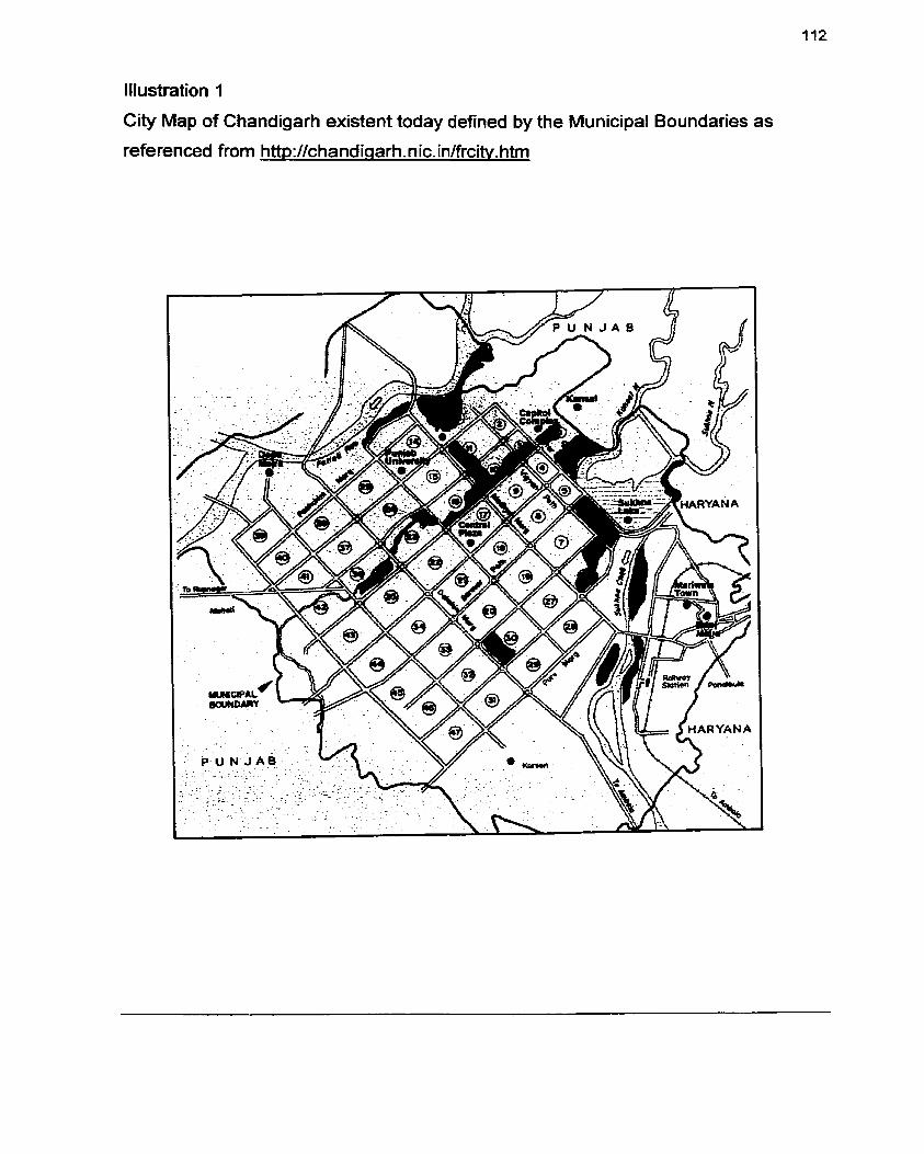
Illustration 1
City Map of Chandigarh existent today defined by the Municipal Boundaries as
referenced from http:l/chandicrarh.nic. in/frciiy. htm

Illustration 2
Master Pian for Chandigarh by Albert Mayer RAlC Journal, 1955 (Evenson Noma,
Chandigarh, 1966)
The shaded portion indicates the area of initial development while the lower portion outlines the projected area of eventual expansion.

Illustration 3
The 'leaf plan' of Chandigarh by Mathew Nowicki Scherne 1, Evenson Noma.
Chandigarh, 1966.

Illustration 4
The 'leaf plan' of Chandigarh by Mathew Nowicki Scheme 2, Evenson Noma.
Chandigarh, 1966.
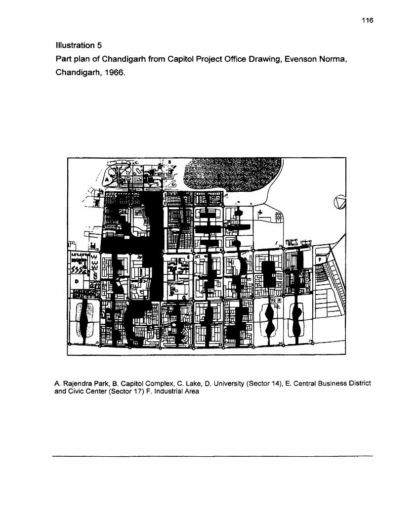
Illustration 5
Part plan of Chandigarh from Capitol Project Office Drawing, Evenson Norma,
Chandigarh, 1966.
A. Rajendra Park, B. Capitol Cornplex, C. Lake, D. University (Sector 14), E. Central Business District and Civic Center (Sector 17) F. Industrial Area

Illustration 6
Le Corbusier's study sketches for Chandigarh, Modular I 1. Evenson Norma,
Chandigarh, 1966.

Illustration 7
Le Corbusier's study sketches for Chandigarh, Modular II. Evenson Norma,
Chandigarh, 1966.

Illustration 8
Le Corbusier's study sketches for Chandigarh, Modular II. Evenson Nona.
Chandigarh, 1966.
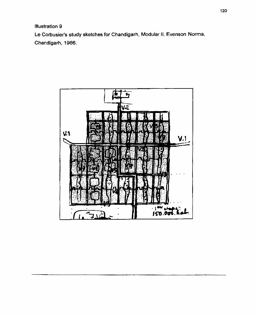
Illustration 9
Le Corbusier's study sketches for Chandigarh, Modular II. Evenson Norma,
Chandigarh, 1966.

Illustration 10
Sector, Evenson Norma, Chandigarh, 1966
Sector 22. the first residential sector developed in Chandigarh. The sector is surrounded by V3 avenues intended for rapid traffic and bisected by the V4 bazaar street. The V5 loop road serves as primary trafic distributor while short V6 roads serve housing groups. A. Government housing. B. Private housing, C. Junior secondary school, D. Bazaar, E. Health center.

Illustration 1 1
Plan of capitol area with Rajendra park at left and capitol complex at right, Evenson
Noma, Chandigarh, 1966

l llustration 12
Final plan of capitol complex showing revisions made as of December 1956.
Evenson Noma, Chandigarh, 1966
A. Secratariat B. Assembly, C. Museum of Knowledge, D. Open hand monument E. High court annex, F. High court.

Illustration 13
Capitol cornplex, preliminary scheme by Le Corbusier, employing high rise
secretariat. Evenson Norma, Chandigarh, 1966
A. Secretariat, B. Assembly, C. Governors Palace, D. High court.
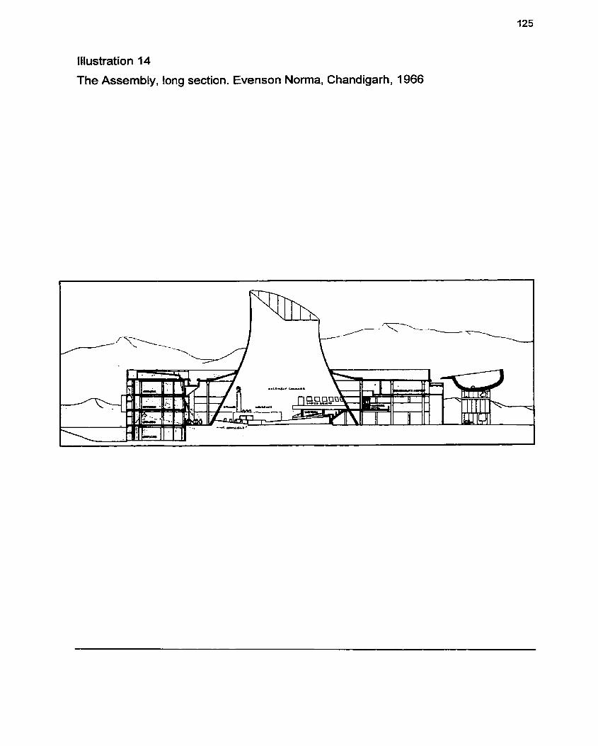
Illustration 14
The Assembly, long section. Evenson Norma, Chandigarh, 1966

1 26 Illustration 15
Plans of Chandigarh and Brasilia Compared, Superblock Comparisons from
Architectural Forum November 1960. Masterplan Comparisons from Architecture in
Australia, December 1 959, (Evenson Noma, Chandigarh, 1966)
superblock of dia form one
For the Brasilia
niirnnca nf rnmnarisnn Chandiaarh and gr ,-. ,,,, ,. ,...,,. .--.., -..-..-.,-.. . -..- -:asib amhown. ~he'residential is compared with the sector of Chandigarh. Four 800 ft. superblocks of Bras
sector. Both Chandigarh and Brasilia had Rat sites which incorporate man made lakes. 60th plans embody monumental government complexes and employ residentila superblock unit. As both were administrative capitals with no established economic base, industries were minimal. Chandigarh was relatively compact with its principal avenues forrning the main axes. In Brasilia, the city itself took a linear cross axial configuration. A. Government cornplex, B. Central business district, C. Railroad station and industrial area, D. Residential superblock areas.
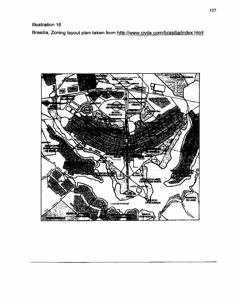
Illustration 16
Brasilia, Zoning layout plan taken from htt~://www.civila.com/brasilia/index.html

Illustration 17
Contemporary City for Three Million. A hypothetical City proposed by Le Corbusier,
The City of Tomorrow, 1 929. pl72

lllus
lson
City
tration 18
netric view, Cont
of Tomorrow, I!
lemporary City for Three Million, propose
329. P.171
!d by Le Corbusier, The

Illustration 19
The Voisin' Plan of Paris by Le Corbusier, The City of Tomorrow, 1929. P.279
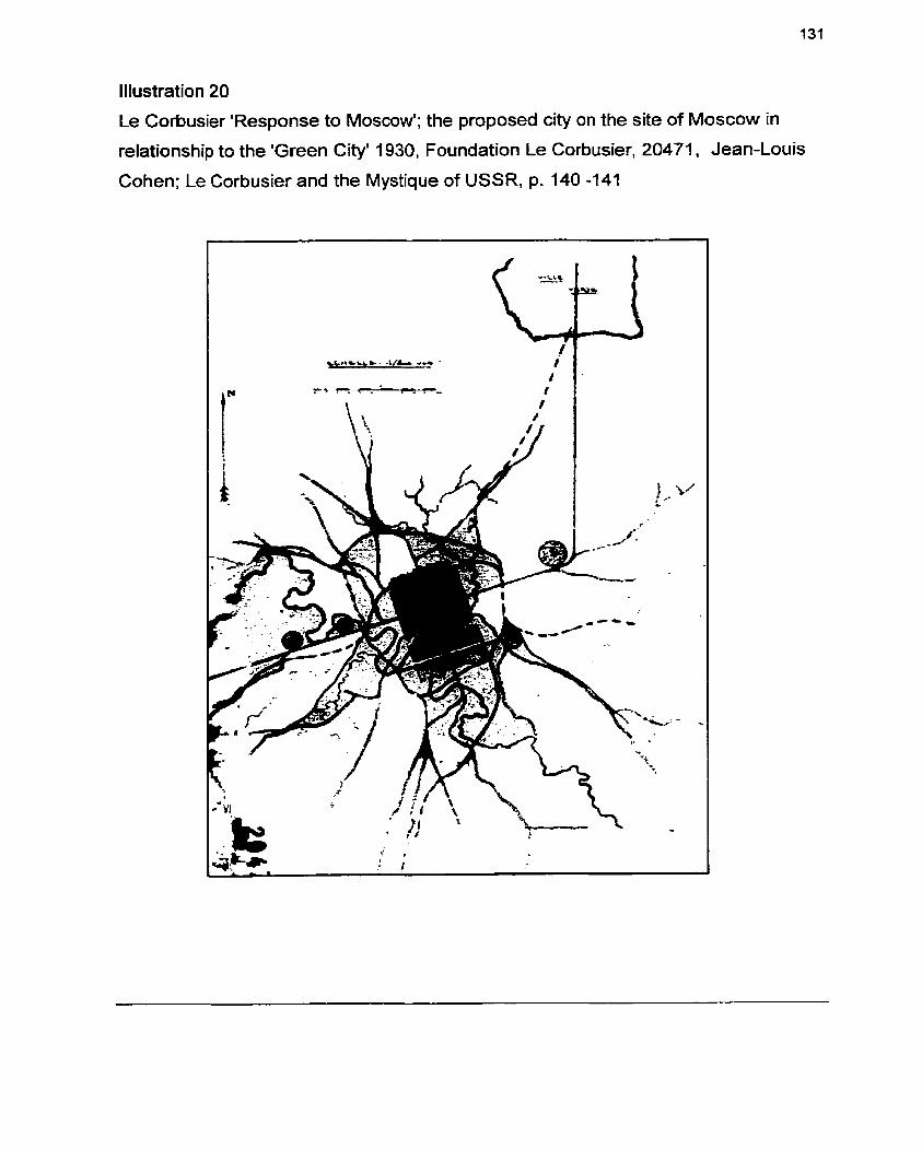
Illustration 20
Le Corbusier 'Response to Moscow'; the proposed city on the site of Moscow in
relationship to the 'Green City' 1930. Foundation Le Corbusier, 20471. Jean-Louis
Cohen; Le Corbusier and the Mystique of USSR, p. 140 -141

Illustration 21
Le Corbusier 'Response to Moscow'; the proposed city on the site of Moscow in
relationship to the 'Green City' 1930, Application of the principles of Ville Radieuse,
Foundation Le Corbusier, 20471, Jean-Louis Cohen; Le Corbusier and the Mystique
of USSR, p. 142

Illustration 22
View of Cybertown interface, an interpretation of a virtual city environment
developed by Blaxxun Interactive. http://www.cvbertown.com

Illustration 23
Plan view of Cybertown Interface, an interpretation of a virtual city environment
developed by Blaxxun Interactive. http:/lwww.cvbertown.com
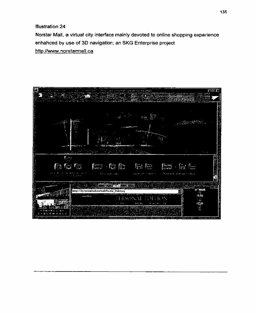
Illustration 24
Norstar Mall, a virtual city interface mainly devoted to online shopping experience
enhahced by use of 3 0 navigation; an SKG Enterprise project
http://www.norstarmall.ca

Illustration 25
Conceptual Navigation as explained for the initial concept of virtual city.
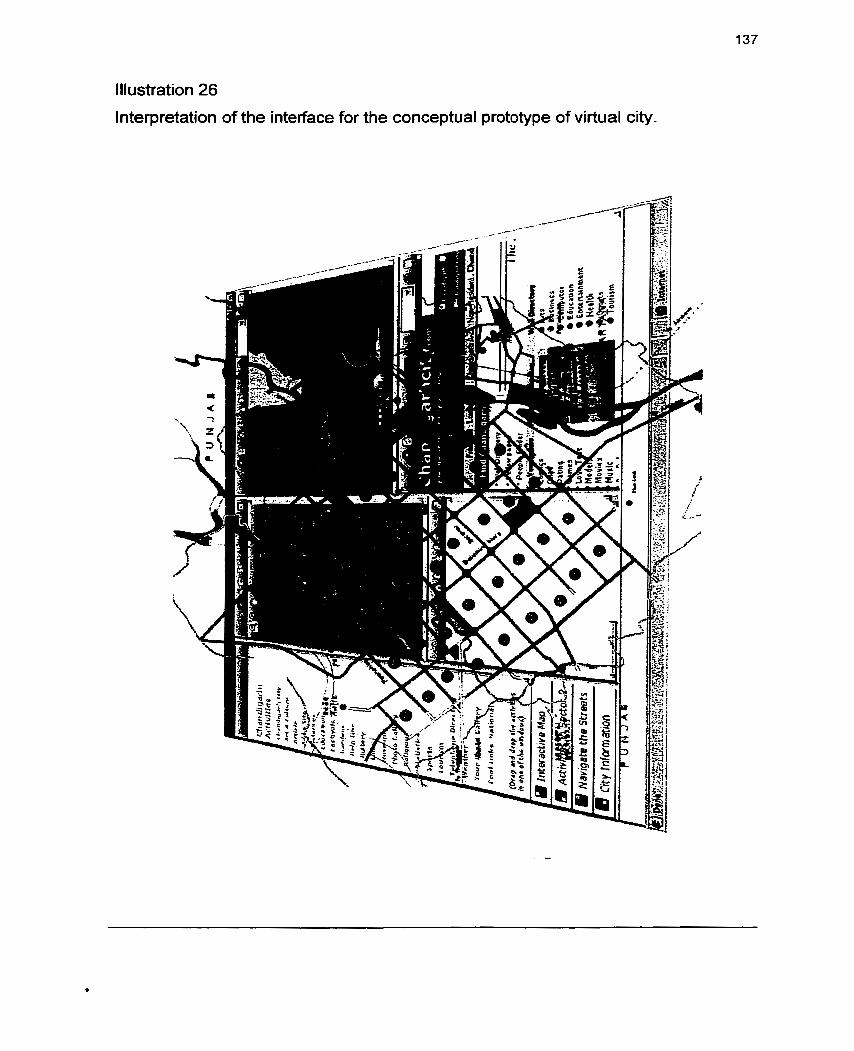
Illustration 26
lnterpretation of the interface for the conceptual prototype of virtual city.

Chandigarh: Acti vifies Ctiandigarh City
A r t L Cdtum
Ar i is ts
Add a Site
Distances
Education
Feetivaie
Gardens
llelp Une
Htstoty
Links
Cltrseunis
Photo Gallery
Religious
S tatistics
Sparts
Taunsni
Talephane Oirectoty
Vlealher
Your Photo Gallery
Caal Unks National
(Drrg and drop the activkies in one o f t h a wlndows)
Web Directory I b.9
8 '1
Yellow papes lfic $; People Findcr
i I $
",y-'& *'(in if,* ., &:' -' j u& *w ?- L;-'.i 1 '
Comics 0 Arts , Char Business a:,
Dating Cornputer 't
Games Educrtion :: Lova Test Entertarnmcnt I: Models Health
6 ,
Movles 6 Sports '.' I I
Music Tourlsm , :i

1 Notes
Chapter 1 1 Foreword of Le Corbusier's Book "The City of Tomorrow and its Planning", published in 1929 2 Foreword of Le Corbusier's Book "The City of Tomorrow and its Planning", published in 1929
Chapter 2 None
Chapter 3 1 From Le Corbusier "The Modular" p.223 re-quoted in Norrna Evenson "Chandigarh" p.73
AS quoted by Le Corbusier in his famous book, "The City of Tomorrow, in 1929.
3 As taken from an extract in the paper presented by Ariel Newman which was re-quoted from The 4
Complete Architectural Works, ed. by Willy Boesiger, O. Stonorov, and Max Bill, 7 vol. 193565- The
paper could be referred at http://tx.technion.ac.il/-ararariel/text.html
5 As taken from a paper written by professor Scott James, Yale University, which is an extract from
his book "Seeing Like a State: How Certain Schemes to lmprove the Human Condition Have Failed".
Exact origins not referred to.
6 Quoted from Le Corbusier's Famous books The City of Tomorrow and it Planning and The Radiant
City. Re-quoted in Professor James Scott's paper 'Tyranny in Bricks and Mortaf, mainly based on his
book, "Seeing Like a State: How Certain Schemes to lmprove the Human Condition Have Failed"
Ibid.
Ibid.
Ibid.
'O Ibid.

140
" Ibid.
l2 As stated By Le Corbusier in his famous book, The City of Tomorrow in 1929 where he defines the
new contemporary, ideal city
l 3 The ongin of this statement was not traced. However the re-quote comes in Professor James
Scott's paper Tyranny in Bricks and Mortar, mainly based on his book, "Seeing Like a State : How
Certain Schemes to lmprove the Human Condition Have Failed"
l4 Quoted by Le Corbusier in his famous Book, The radiant City; re-published in 1964
I bid.
15 Most of the collection comes from the re-quote in Professor James Scott's paper 'Tyranny in Bricks
and Mortar', mainly based on his book, "Seeing Like a State: How Certain Schemes to lmprove the
Human Condition Have Failed"
16 As stated By Le Corbusier in his famous book, The City of Tornorrow in 1929 where he defines the
new contemporary, ideal city.
l7 Ibid.
Chapter 4 1 As stated By Le Corbusier in his famous book, The City of Tomorrow in 1929 where he defines the
new contemporary, ideal city.
2 As stated By Le Corbusier in his famous book, The City of Tomorrow in 1929 where he defines the
new contemporary, ideal city.
3 As stated By Le Corbusier in his famous book, The City of Tomorrow in 1929 where he defines the
new contemporary, ideal city. Most of the part of the above description has been based from the
article; The City that never was- Unrealized Dreams from the online planning magazine;
htt~://www.feedmaq.com/streetlevel/zurfeat. html
4 This part of the research comes from Professor James Scott's paper Tyranny in Bricks and Mortar,
mainly based on his book, "Seeing Like a State : How Certain Schemes to lrnprove the Human
141
Condition Have Failed".
5 A forward to "The City Of Tomorrow" published in 1929. The time, in which this was written was a
perÏod concemed, as had been renaissance, with a perfection of form, in this instance with the
establishment of a forma1 expression considered suitable for a new machine age. Taken from 'The
Modular' p. 61.
Ibid.
The Edict of Chandigarh is the explanation of the ideas of Le Corbusier about Chandigarh. The
extract of this edict has been taken from an online journal about Chandigarh available at
htt~://chandiaarh.nic.in/frarch.htm. The web site is an online journal discussing mainly about the
Development of Chandigarh as a Planned City.
* As quoted by Ravi Kalia in his book "Chandigarh; in search of an identity in 1987
9 As taken from the re-quote in Professor James Scott's paper 'Tyranny in Bricks and Mortar', mainly
based on his book, "Seeing Like a State: How Certain Schemes to lmprove the Human Condition
Have Failed".
10 As written by Le Corbusier in 1959 and Produced by Government of Punjab Administration on their
offtcial web site, 1999
11 Quoted by Le Corbusier in re-quoted by Norma Evenson in Chandigarh 1966.
l2 The compilation of Chandigarh is a collection from the excerpts of the books Chandigarh by Norma
Evenson and "Chandigarh; in search of an identity by Ravi Kalia. Some of the excerpts are also as a
result of on online documentation about the development of Chandigarh available at
Chapter 5 1 The section is based on a paper, Virtual Cities on the World Wide Web- Towards a new
informational system, written by Andy Smith, Martin Dodge, & Simon Doyle of Centre for
Advanced Spatial Analysis, University College, London.

2 The section is based on a Thesis paper called 'Inhibiting Virtual Cities' by Judith Donath
frorn MIT Media Lab.
3 The section is based on a Paper, Virtual Cities on the World Wide Web- Towards a new
informational system, written by Andy Smith, Martin Dodge, & Simon Doyle of Centre for
Advanced Spatial Analysis, University ColIege, London.
4 The extract of this part was extracted from a Thesis paper called 'Inhibiting Virtual Cities' by
Judith Donath from MIT Media Lab.
The section is based on a paper called Building Virhial Worlds- A City Planning Perspective'
by Rob lngram from Department of Computer Science, University of Nottingham.
Chapter 6 None
Chapter 7 1 As quoted in by Le Corbusier in his farnous Book "The City of Tomorrow" p.158.
2 As cited by Jane Drew in "Chandigarh; Capital City Project' Architects' year Book 5 p.56 re-quoted
by Norma Evenson in Chandigarh, 1966, p. 31.
Chapter 8 1 Quoted by Le Corbusier in The Modular, p.223 re-quoted by Norma Evenson in Chandigarh 1966, p.
35
2 What Corbu has been upto, "The Architectural Forum", 99:142-149 Sept 1953, re-quoted by Norma
Evenson in Chandigarh 1966, p. 29

Primary Literature Review
This literature review is meant to highlight the reasons of motivation of this thesis. An
enormous amount of work has been carried out in trying to create different views
and models of virtual city environments. However this thesis takes a similar research
to another level when it tries to establish a common language in between
architecture and technology by trying to CO-relate the principles of Le Corbusier, an
Architect-Town Planner to creating an ideal virtual environment.
A few scholars have done a research in this area of interest earlier in the forms of
theses, research papers, articles, etc. Their work has had a direct impact and has
been a great help in the development of this thesis. Short summaries of the works of
these people are mentioned below.
1. Donath Judith (Ph.D. MIT Media Lab) Thesis: 'lnhibitins Virtual Cities'
The goal of this research was to develop an approach to the design of on-line social
environments. In order to foster the deve!cpment of vibrant and viable online
comrnunities, the environment - Le. the technical infrastructure and user interface,
one must provide the means to communicate social cues and information. The
participants must be able to perceive the social patterns of activity and affiliation and
the community must be able to evolve a fluid and subtle cultural vocabulary.
2. In~ram Rob (CASA London) Research paper: Buildinq Virtual Worlds: A Citv
Planninq Perspective.
A Research that studies from the disciplines city planning and architecture to raise
some of the issues which may be important in the design, developrnent and
administration of these environments in order to make them pleasant, usable and
manageable.
3. Dieber~er Andreas, Emorv University. Research Paper: A Citv Metaphor
for supporting Navigation in Corn~lex Information Spaces
Tries to emphasize and prove that The use of appropriate navigation metaphors can
help to rnake the structure of modern information systems easier to understand and
therefore easier to use.

1. Alexander, C., 'H City is Not a Tree", Architectural Forum. 122, ( l ) , 58-62 and
(2), 58-61, 1965.
In Kaplan, S. and Kaplan, R. (Eds.). "Humanscape - Environments for People"
Ulrich's Books Inc., Ann Arbor, 1982, pp. 377-402.
2. Batty M., "Cornputable City" State University of New York, Buffalo, Keynote
Add ress,
3. Batty M., "New Technologies for Urban Designers- "The Venue Project"
University College of London, Paper,
4. Benedikt, M. 'Cyberspace; First Steps" MIT Press, Massachusetts Institute of
Technology, 1992
5. Burks, L. Harvard University, "lnfomation Architecture- The Representation of
Vidual Environments" Graduate School of Design, Master of Architecture Thesis,
1994
6. Camp bel l D. A. "Design in Virfual Environrnents Using Architectural Metaphor"
A H IT Lab Gallery, Master of Architecture Thesis, University of Washington 1 996
7. Card, SmK., Robertson, G.G., and Mackinley, J.D. "The Information Visualizec
An lnfonnation Workspace", CH1'91, 1991, pp. 181-188.
8. Card, S.K., Robertson, G.G., and York, W. "The WebBook and the Web
Forager: An Information Workspace for the World- Wide Web < CH 1'96, ACM

Press, Vancouver, BC, 1996, pp. 11 1-1 17.
9. Chalmers, M., "Using a Landscape Metaphor to Represent a Corpus of
Documents", in Proceedings of European Conference on Spatial Information
1 O.Chang, B.-W. and Ungar, D. "Animation: From Cartoons to fhe User Interface",
UIST'93, Atlanta, 1993, pp. 45-56.
11 .Clanton, C. and Young, E. "Film CraR in User Interface Design", CH1'94 Tutorial
Notes, Boston, 4/94, 1994.
12. Cohen, J.L. "Le Corbusier and the Mystique of USSR" Princeton University
Press, 1992
13. Le Corbusier, (Charles-Edouard Jeanneret,) "The City of Tomorrow and its
Planning", John Rodher Press, London. 1929.
14. Le Corbusier, "Looking at City Planning" Grossman Publishers, new York 1971.
15. Le Corbusier, "Chandigah: City and Musee" Garland Publishing Inc. 1983.
16. Dieberger, A. and Bolter, J.D. "On The Design of HyperSpaces",
Communications of the ACM, (1 995), p. 98.
17. Donath, J. S. MIT Media Lab "inhibiting Virtual City", Media and Arts Sciences
Ph.3. Thesis, 1997
18. Doxiadis, C. A. "Behveen Dystopia and Utopia", London: Faber and Faber,
1966.
19. Erickson, T. "From Interface to Interplace: The Spatial Environment as a
Medium for Interaction", COSIT'93, EIba, 1993, pp. 391-405.
20. Evenson, N. ffChandiga,.h" University of California Los Angeles Press 1966.
21 . Ferris H. "Metropolis of Tomorro w" Princeton Architectural Press, re-issue
1998.
22. Fishman, R. "Urban Utopias in the Twentieth Century" New York: Basic Books,
1977.
23.Hollan, J. and Stornetta, S. "Beyond being there" In Proceedings of CHI '92
Conference of Human Factors in Computer Systems. Monterey, CA. 1992.
24. lngram, R. and Benford, S. "Improving the Legibility of Virtual Environmentsff,
Proc. of the 2nd Eurographics Workshop on Virtual Environrnents, Monte Carlo,
1995.
25. lngram, R. University of Nottingham, Paper, " Building Virlual Worlds, A City
Planning Perspective" 1996
26. lngram, R., Bowers, J., and Benford, S. ''Building Vidual Cities: Applying Urban
Planning Principles to the Design of Virtual Environments", Proc. VRST'96, ACM
Press, HongKong, 1996.
27. Jacobs, J. "The Death and Life of Great Amencan Citiesfrl Vintage Books, New
York, 1961.

148
28. Kalia, R. "Chandigah; in search of an identity" Southern Illinois University Press,
1987.
29. Lakoff, G. and Johnson, M. "Metaphors we live by", Univ. of Chicago Press,
1980.
30. Li, Y., Article, "Architecture in Cyberspace or Cyberspace in Architecture "
National University of Singapore.
31 . Leiss, W. , Kline, S. and J hally, S. "Social Communication in Advertising:
Persons, Products, and Images of Well-Being ". London: Routledge 1 990.
32. Lynch, K. "The Image of The City", MIT Press, 1960.
33. Milgram, S. "The Individual in a Social World" Reading, MA: Addison-Wesley
1977.
34. Mitchell, W. "City of Bitst1. Cambridge, MA: The MIT Press 1995.
35. More T. (Sir) " Utopia" Hackett Publishing, Reprinted in 1965.
36. Mumford L. "Art and Technics" New York: Columbia University Press 1952.
37. Scott J. C. "Seeing Like a State : How Certain Schernes to lmprove the Human
Condition Have Failed" Yale U n iversity Press, 1 999
38.Smith A., Dodge M., Doyle S., "VNtual Cities on the World Wide Web-Towards a
New Virtual City Information System" , Center for Advanced Spatial Analysis,
University College London, Article 1999

149
39. Smith A., Dodge M., Doyle S., "Visual Communication in Urban Planning and
Design1', Center for Advanced Spatial Analysis, University College London,
Article 1 999.
40. Tanney, S. "A Design Method For Virfual Environments" H ITL Washington,
Paper
41. Tognauini, B. "Tog on Software Design ", Addison-Wesley, 1 996.
42. Whyte, W., 'City: Rediscovering the Cenfef", Anchor Books, New York. 1988.
43. Wright, F. L., "Broadacre City: A New Community Plan", Architectural Record,
Vol. 77, April, 1935.
44. Wirth, L. 1938. "Urbanism as a way of life" The American Journal of Sociology.
XLlV 1 (July 1938). Reprinted in LeGates and Stout, 1996.

1 REFERENCES FROM THE WORLD WlDE WEB I
[wJi. AN OUTLOOK FOR URBAN PLANNING IN CYBERSPACE:
Toward the Construction of Cyber Cities with the Application of Unique
Characteristics of Cyberspace. Narushige Shiode
[w]Z A CITY METAPHOR TO SUPPORT NAVIGATION IN COMPLEX
INFORMATION SPACES:
The use of appropriate navigation metaphors can help to make the structure
of modern information systems easier to understand and therefore easier to
use.
Andreaç Dieberger
htt~:lI~~l~.mindsprinp.com/%7Eju~le5Mlritin~slPublications/JVisLang
Citv.html
[w]3. BLAXXUN INTERACTIVE
Blaxxun Interactive is the global technology leader for Virtual Worlds basis
software, enabling more natural communication and interaction among people
on the Internet in the areas of entertainment, e-commerce, and business.
Virtual Worlds transform websites into feature-rich, interactive environments-
from simple chat, to cornmunities, to even applications with lively social
infrastructures.
http:llwww.blaxxun.com
[w]4. BRASlLlA
Excerpts from the Environmental Communications Archives on Oscar
Niemeyer and his plans for Brasilia; The Capital of Brazil

[w]5. BUILDING VIRTUAL WORLDS:
a city planning perspective.
Rob lngram
http:/lwww.casa.ucl.ac.uWplanning/articles3/vcitv.htm
[wj6. CASA
The Center for Advanced Spatial Analysis (CASA) is an initiative within
University College London to develop emerging cornputer technologies in
several disciplines which deal with geography, space, location and the built
environment.
[w]7. CHANDIGARH PERSPECTIVES
1s a non-profit organization set up as a collaborative effort between the
Chandigarh Administration and concerned architects and planners. The idea
of setting up this organization was initiated by the need to celebrate the 50th
Anniversary of the conception of the idea of planning Chandigarh.
The organization aims to facilitate research, organize exhibitions, seminars,
and lectures and document and publish issues related to the architecture and
urban planning concepts of Chandigarh.
[w]8. CITY OF BITS:
Space, Place and the Infobahn.
William J. Mitchell
http://mitpress.mit.edule-bookslCity of Bits/
152
[w]9. CITYSPACE, CYBERSPACE, AND THE SPATIOLOGY OF INFORMATION:
"The concept of space has been critical to architectural theory for over
seventy years now ... It remains however, an elusive idea, on the one hand
meaning and referring to everything, on the other hand meaning and referring
to nothing.. ."
Michael Benedikt
[w]I 0. ClTlES OF THE FUTURE - 2000 V2.0:
Urban space today is a site of unparalelied change, alteration and dynarnism.
The impact of globalised systemç of economic power, rnediated by
electronics, have lent the contemporary city a mutable aspect. Cities seem to
seeth with the potential for self growth, grown organically from the material
that is the media age. No-one it would seern has a strong handle on where
contemporary cities are going. Gone are the heady days of certainty which
thrust skyscrapers out of a landscape of rnining and manufacturing. These
are the fluid and liquid city days.
David Cox
[w]l 1 . COLLABORATIVE URBAN DESIGN THROUGH COMPUTER
SIMULATIONS.
A senior honours essay prepared for the School of Urban and Regional
Planning, University of Waterloo, Ontario, Canada April 1996
David Goodfellow
http:i/www.fes.uwaterloo.calul~bhall/research/david~eb/HMTHESIS.html
[w]12. DESIGN IN VIRTUAL ENVIRONMENTS USlNG ARCHITECTURAL
METAPHOR
A HIT Lab Gallery, Master of Architecture Thesis, University of Washington
1996
Dace Campbell
[w]13. FEED
Excerpts of the Plan for the City of Three Million by Le Corbusier. An online
planning magazine.
http://~~~.feedma~.comlstreetleveIlzu rfeat. html
[w]14. GOVERNMENT OF CHANDIGARH
Official Web Site of Chandigarh Administration
Developed by National Informatics Centre contains information about
Chandigarh provided by Chandigarh Administration.
htt~://chandigarh.nic.in/
[w]15. LE CORBUSIER PLANNING PRINCIPLES
A product of the Ten Planning Principles for the Next Ten Million is the
LeCorbusier-40. The title of this development concept is in recognition of Le
Corbusier, one of the founding fathers of the Modernist movement and the
author of The City of Tomorrow and Its Planning (1929).
http:llweplancities.com/lecorb 40.htm
[w]16. MAPPING A VIRTUAL CITY
What would a virtual city in cyberspace look like? Well. a sequence of
'satellite' maps of AlphaWorld provide us with a pretty good idea These
fascinating maps show the growth of buildings, streets, parks and gardens
designed and constructed by the citizens of the virtual world of AlphaWorld
over the past five years. The virtual cartographer responsible is Roland Vilett,
the lead programmer on the virtual world system at Activeworlds.com, which
encompasses AlphaWorld and several hundred other worlds on the lnternet

htt~:llma~pa.mundi.netlmapslmaps 01 31
[w]17. NORSTAR MALL
An online shopping maIl using VRML and self developed browsers offers
consumers a realistic maIl environment to shop in and focus attention on the
tenant's key product offerings. Complete with information desks and window-
shopping capabilities, the 3-D version of NorstarMall.ca is sure to redefine the
way Canadians shop online.
[w]18. PLANET 9 STUDIOS
Planet 9 Studios is a 3D content Company focused on providing real business
solutions for the Internet. We have produced over 200 virtual worlds for a
variety of applications such as marketing, advertising, product visualization,
training, architectural simulation, rnilitary visualization and entertainment. Our
animation is used for TV, commercials and real estate. We are constantly
incubating new software products for companies and helping them to reach
market.
[w]19. QTVR
A web site for references on quick tirne virtual reality movies.
http:l/www.ta~it.ab.ca/qtvr. htm
[ ~ ] 2 0 . RESEARCH PAPER - VIRTUAL ARCHITECTURE
Virtual Space (the) Transformation of Reality
Helmut Tichy, M.A. Computer lmaging in Architecture
http:ll~~~.archlab.tuwien.ac.atl-htichlresearchpaerl .htrnl

[w]21. SQUARE ONE PRODUCTIONS
is a Photomontage animation and simulation Company that provides
persuasive, credible and cost-effective communication tools, such as 3D
visual simulations and video,
w22. THE INFORMATION CITY PROJECT:
A virtual reality user interface for navigation in information spaces.
Andreas Dieberger & Jolanda G. Tromp
http:llwww.mindsprinci.com/%7Eiuaale5MlritincislPublicationsNRV.html
w23. THE COMPUTABLE CITY:
"By the year 2050, everything around us will be sorne forrn of cornputer.. ."
Michael Batty
[w]24. TOWARDS THE VIRTUAL CITY:
VR & lnternet GIS for Urban Planning.
Martin Dodge, Simon Doyle, Andy Smith, & Stephen Fleetwood
[w]25. THE VIRTUAL VILLAGE
The Virtual Village is a unique initiative which, by taking advantage of the
latest advances in telecomrnunications technology, addresses the need for
the provision of local services, information and opportunities to rural
cornmunities. To deliver these services the Virtual Village is creating a
network of computer and video conferencing facilities which links community
centres in the rural villages with each other and the rest of the world
[w]26. TOWARDS THE VIRTUAL CITY
Paper on: Virtual Reality & lnternet GIS for Urban Planning
Martin Dodge, Simon Doyle, Andy Smith & Stephen Fleetwood
[w]27. TYRANNY IN BRIKS AND MORTAR
A paper by Yale professor
James Scott
http://www.thearnericanenterprise.ornltaejfOOh. htm
[~]28. VlRTUALlZATlON AND MULTI-CULTURAL GLOBAL CITIES:
This article briefly examines the implications of both the technical capacity for
instantaneous transmission and the capacity to link people at indeterminate
locations, for civic culture and public space.. .
Carlos Hernan Betancourth
http:llwww.arch-maci.com/l/coll/coll2t. html
[~]29. VIRTUAL CITIES: THE RE-MODELLING OF URBAN CONTEXTS
1997, final year dissertation for the B.A.(Hons) History of Art degree at Leeds
University
Kieron Johnson
htt~:l/www.leeds.ac.uklopted/studentslkieron. htm
[w]30. YATRAlNDlA (TOUR INDIA)
An informational web site about Chandigarh.
http:l/www.yatraindia.comlChandiqarh/

Appendix I
Illustrations of different types of Browser Interfaces -
1. Cubic Eye: A browser interface that utilises the concept of browsing in
three dimensions. (http://www.2ce.com)
2. Opera: A browser interface designed for multiple choice browsing.
3. Virtual London: A browser interface designed to display the concept of
Virtual London. (CASA, UK)


Cubic Eve Browser Example 2
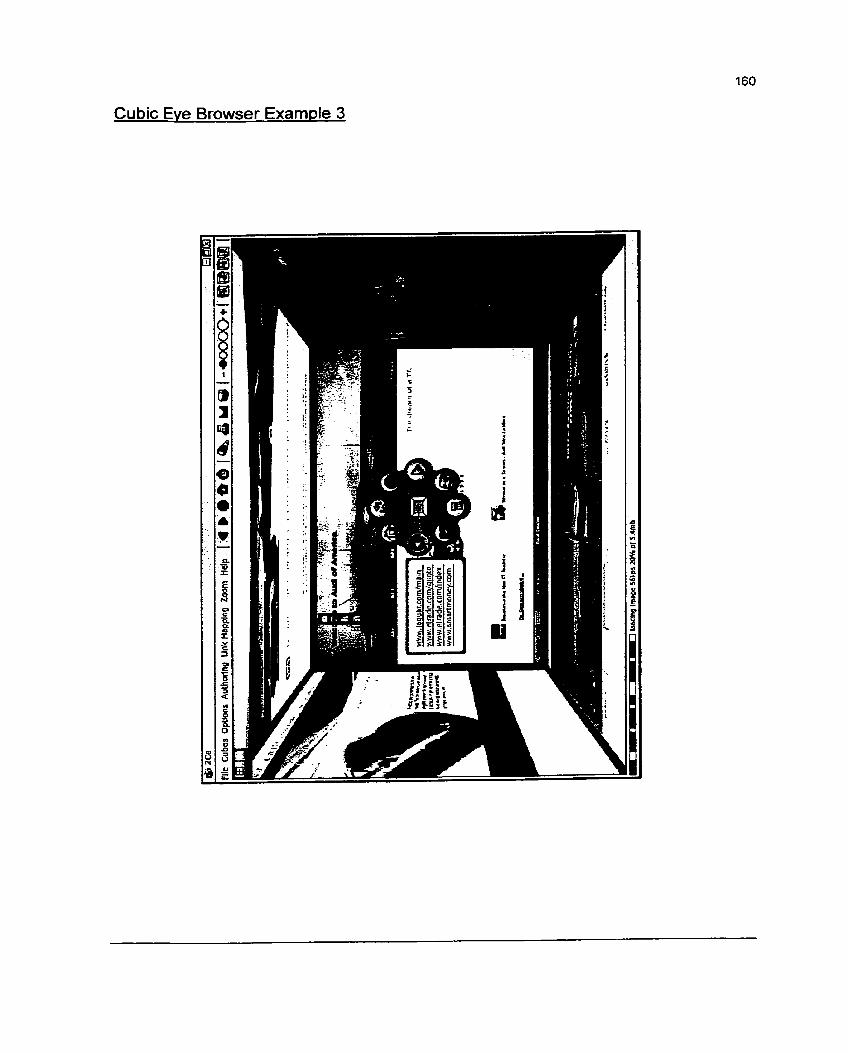
Cubic Eve Browser Examde 3

Suieel c Du!aed leog < s l i o o s l o l o ~ c siioaç s u e x u n j < ou!poy c ouped olny < svoog c ~u!aaoqg :se!iofia1e3
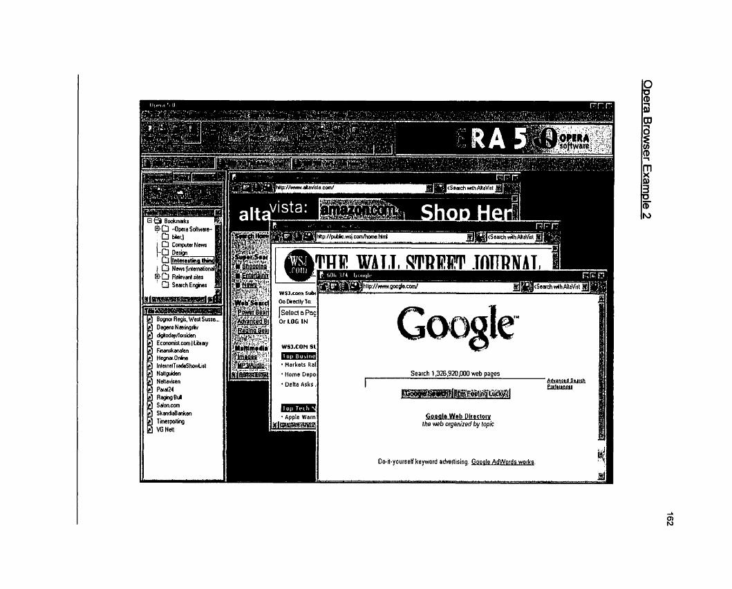
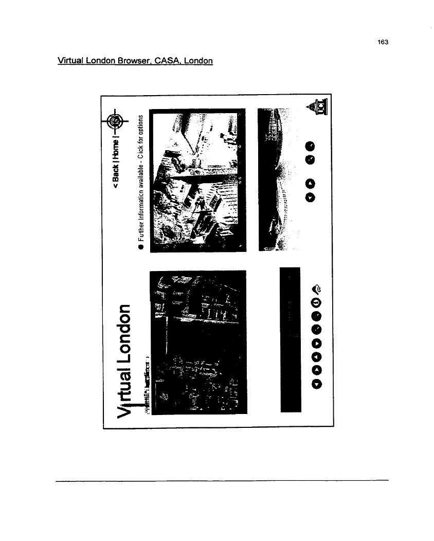
Virtual London Browser. CASA, London

Appendix II
CD-ROM, containing the electronic format of Document and the prototype. (PC
Version)