KBP CONSULTING, INC. - Monroe County, FL
12
KBP CONSULTING, INC. 8400 North University Drive, Suite 309, Tamarac, Florida 33321 Tel: (954) 560-7103 Fax: (954) 582-0989 May 13, 2020 Chelsea Vanadia, Esq. Smith Hawks 138 Simonton Street Key West, Florida 33040 Re: Safe Harbor Community Center Overlay District Stock Island, Florida FLUM Traffic Statement Dear Chelsea: Per your request, KBP Consulting, Inc. has prepared this traffic impact statement associated with the Land Development Regulation Text Amendment Application for the proposed Safe Harbor Community Center Overlay District on Stock Island, Monroe County, Florida. This proposed District will consist of an area bounded by Front Street to the east, Fourth Avenue to the north, Fifth Avenue to the north, Shrimp Road to the west, and Shrimp Road to the south but excluding that certain property owned by the Utility Board of the City of Key West and Florida Keys Aqueduct Authority bounded by Front Street to the east. Specifically, as it relates to this proposed District and traffic impacts, there will be an increase in the maximum density for hotel / motel development. Currently, the maximum allowable density for this use within the +/- 48.18-acre upland area is 15 units per acre less a 20% open space requirement which yields an actual buildable density of 12 units per acre. The proposed maximum density will be 20 units per acre less a 20% open space requirement which yields an actual buildable density of 16 units per acre. The resulting increase in maximum allowable hotel / motel density will be four (4) units per acre for a total increase of 192 hotel / motel units. The maximum Floor Area Ratios (FARs) for the remaining land uses do not change. However, for clarification purposes, the FAR for the light industrial use has been adjusted to 0.60 in accordance with Policy 101.5.25 of the County’s Comprehensive Plan. (Please see Attachment A for the relevant excerpts from the referenced Comprehensive Plan.) Trip Generation Analysis A trip generation analysis has been conducted for the purposes of estimating the increase in traffic associated with the proposed increase in density for the hotel / motel land use. The trip generation analysis is based upon information contained in the Institute of Transportation Engineer’s (ITE) Trip Generation Manual (10 th Edition). According to the subject ITE manual, the most appropriate land use category for the subject use is Land Use #310 – Hotel. The trip generation rates and equations used to determine the vehicle trips associated with this analysis are shown below.
Transcript of KBP CONSULTING, INC. - Monroe County, FL

KBP CONSULTING, INC.
8400 North University Drive, Suite 309, Tamarac, Florida 33321 Tel: (954) 560-7103 Fax: (954) 582-0989
May 13, 2020 Chelsea Vanadia, Esq. Smith Hawks 138 Simonton Street Key West, Florida 33040 Re: Safe Harbor Community Center Overlay District
Stock Island, Florida FLUM Traffic Statement Dear Chelsea: Per your request, KBP Consulting, Inc. has prepared this traffic impact statement associated with the Land Development Regulation Text Amendment Application for the proposed Safe Harbor Community Center Overlay District on Stock Island, Monroe County, Florida. This proposed District will consist of an area bounded by Front Street to the east, Fourth Avenue to the north, Fifth Avenue to the north, Shrimp Road to the west, and Shrimp Road to the south but excluding that certain property owned by the Utility Board of the City of Key West and Florida Keys Aqueduct Authority bounded by Front Street to the east. Specifically, as it relates to this proposed District and traffic impacts, there will be an increase in the maximum density for hotel / motel development. Currently, the maximum allowable density for this use within the +/- 48.18-acre upland area is 15 units per acre less a 20% open space requirement which yields an actual buildable density of 12 units per acre. The proposed maximum density will be 20 units per acre less a 20% open space requirement which yields an actual buildable density of 16 units per acre. The resulting increase in maximum allowable hotel / motel density will be four (4) units per acre for a total increase of 192 hotel / motel units. The maximum Floor Area Ratios (FARs) for the remaining land uses do not change. However, for clarification purposes, the FAR for the light industrial use has been adjusted to 0.60 in accordance with Policy 101.5.25 of the County’s Comprehensive Plan. (Please see Attachment A for the relevant excerpts from the referenced Comprehensive Plan.) Trip Generation Analysis A trip generation analysis has been conducted for the purposes of estimating the increase in traffic associated with the proposed increase in density for the hotel / motel land use. The trip generation analysis is based upon information contained in the Institute of Transportation Engineer’s (ITE) Trip Generation Manual (10th Edition). According to the subject ITE manual, the most appropriate land use category for the subject use is Land Use #310 – Hotel. The trip generation rates and equations used to determine the vehicle trips associated with this analysis are shown below.

KBP CONSULTING, INC.
8400 North University Drive, Suite 309, Tamarac, Florida 33321 Tel: (954) 560-7103 Fax: (954) 582-0989
Hotel – ITE Land Use #310
Weekday (wt. avg.): T = 7.99 (X) where T = number of trips and X = number of rooms
AM Peak Hour: T = 0.50 (X) – 5.34 (59% in / 41% out) PM Peak Hour: T = 0.75 (X) – 26.02 (51% in / 49% out)
Table 1 below summarizes the increase vehicle trips expected to be produced by the proposed increase in the hotel / motel density within the Safe Harbor Community Center Overlay District on Stock Island.
DailyLand Use Trips In Out Total In Out Total
ProposedHotel 192 Rooms 1,534 54 37 91 60 58 118
Compiled by: KBP Consulting, Inc. (May 2020).Source: Institute of Transportation Engineers (ITE) Trip Generation Manual (10th Edition).
AM Peak Hour Trips PM Peak Hour TripsIncreaseProposed
Table 1Trip Generation Summary
Safe Harbor Community Center Overlay District - Stock Island, Florida
As indicated in this table, the net increase in external vehicle trips anticipated to be generated by the proposed increase in density consists of approximately 1,534 vehicle trips during a typical day, 91 vehicle trips during the weekday AM peak hour (54 inbound and 37 outbound), and 118 vehicle trips during the weekday PM peak hour (60 inbound and 58 outbound). Trip Distribution A trip distribution analysis was performed based on the nearby population areas (as documented in the Monroe County Traffic Report Guidelines Manual), the existing transportation network, the location of the subject project, and engineering judgment. Most of the project-related trips are anticipated to access US 1 / Overseas Highway. Table 2 below summarizes the anticipated trip distribution for the Safe Harbor Community Center Overlay District.
Direction Distribution (%)East (US 1 North) 25%West (US 1 South) 50%
South Side of Stock Island (Local) 25%North Side of Stock Island 0%
Source: Based upon population data contained within the Monroe County Traffic Report Guidelines Manual.
Table 2Safe Harbor Community Center Overlay District
Project Trip DistributionStock Island, Florida
KBP CONSULTING, INC.
8400 North University Drive, Suite 309, Tamarac, Florida 33321 Tel: (954) 560-7103 Fax: (954) 582-0989
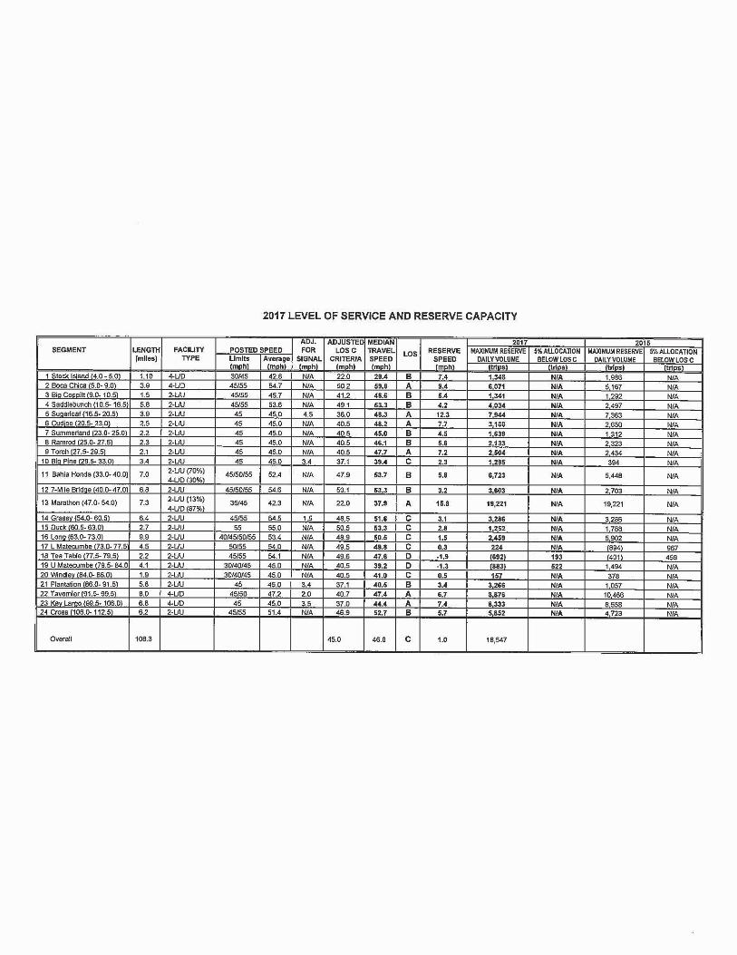
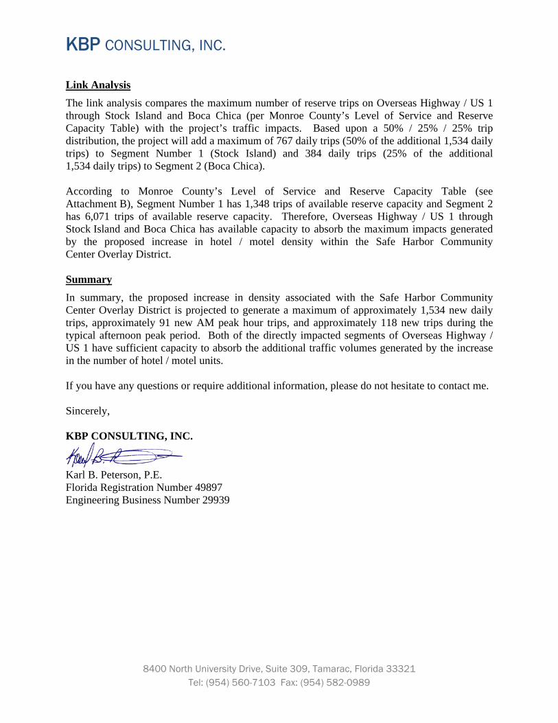
Link Analysis The link analysis compares the maximum number of reserve trips on Overseas Highway / US 1 through Stock Island and Boca Chica (per Monroe County’s Level of Service and Reserve Capacity Table) with the project’s traffic impacts. Based upon a 50% / 25% / 25% trip distribution, the project will add a maximum of 767 daily trips (50% of the additional 1,534 daily trips) to Segment Number 1 (Stock Island) and 384 daily trips (25% of the additional 1,534 daily trips) to Segment 2 (Boca Chica). According to Monroe County’s Level of Service and Reserve Capacity Table (see Attachment B), Segment Number 1 has 1,348 trips of available reserve capacity and Segment 2 has 6,071 trips of available reserve capacity. Therefore, Overseas Highway / US 1 through Stock Island and Boca Chica has available capacity to absorb the maximum impacts generated by the proposed increase in hotel / motel density within the Safe Harbor Community Center Overlay District. Summary In summary, the proposed increase in density associated with the Safe Harbor Community Center Overlay District is projected to generate a maximum of approximately 1,534 new daily trips, approximately 91 new AM peak hour trips, and approximately 118 new trips during the typical afternoon peak period. Both of the directly impacted segments of Overseas Highway / US 1 have sufficient capacity to absorb the additional traffic volumes generated by the increase in the number of hotel / motel units. If you have any questions or require additional information, please do not hesitate to contact me. Sincerely, KBP CONSULTING, INC.
Karl B. Peterson, P.E. Florida Registration Number 49897 Engineering Business Number 29939

Attachment A
Relevant Excerpts From the County’s Comprehensive Plan

Policy 101.5.25
Monroe County hereby adopts the following density and intensity standards for the future land use categories, which are shown on the FLUM and described in Policies 101.5.1—101.5.20. [F.S. § 163.3177(6)(a)1.]
Future Land Use Densities and Intensities Minimum Open Space Ratio (c) Future Land Use Category and
Corresponding Zoning Residential (l) Nonresidential
Allocated Density (a) (per upland acre)
Maximum Net Density (a)(b) (per buildable acre)
Maximum Intensity (floor area ratio)
Agriculture/Aquaculture (A) (d) (no directly corresponding zoning)
0 du 0 rooms/spaces
N/A N/A
0.25 Per underlying zoning
Airport (AD) (AD zoning)
0 du 0 rooms/spaces
N/A N/A
0.10 0.20
Commercial (COMM) (C1 and C2 zoning)
0 du 0 rooms/spaces
N/A N/A
0.15—0.50 0.20
Conservation (C) (CD zoning)
0 du 0 rooms/spaces
N/A N/A
0.05 0.90
Education (E) (d) (no directly corresponding zoning)
0 du 0 rooms/spaces
N/A N/A
0.30 Per underlying zoning
Industrial (I) (I and MI zoning)
1 du 0 rooms/spaces
2 du N/A
0.25—0.60 0.20

Institutional (INS) (d) (no directly corresponding zoning)
0 du 15 rooms/spaces
N/A 24 rooms/spaces
0.30 Per underlying zoning
Mainland Native (MN) (MN zoning)
0.01 du 2 spaces (e)
N/A N/A
0.03
0.95—0.99
Military (M) (MF zoning)
6 du 10 rooms/spaces
12 du 20 rooms/spaces
0.30—0.50 0.20
Mixed Use/Commercial (MC) (f)(g) (SC, UC, DR, RV, MU and MI zoning)
1 du (DR, MU, MI) 3 du (SC) 6 du (UC) Commercial Apartments (RV) (h) 5—15 rooms/spaces
2 du (MI) 6-18 du (SC) (k) 12 du (UC) 12—18 du (MU) (k) 18 du (DR) 10—25 rooms/spaces
0.10—0.45 (SC, UC, DR, MU) <2,500 SF (RV) 0.30—0.60 (MI)
0.20
Mixed Use/Commercial Fishing (MCF) (f) (CFA, CFV, CFSD zoning)
1 du (CFSD-20) (i) 3 du (CFA, all other CFSD) 1 du/lot (CFV) 0 rooms/spaces
12 du (CFA, CFSD) N/A (CFV) N/A
0.25—0.40
0.20
Preservation (P) (d) (P zoning)
0 du 0 rooms/spaces
N/A N/A
0
1.00
Public Buildings/Lands (PB) (d) (no directly corresponding zoning)
0 du 0 rooms/spaces
N/A N/A
0.30 Per underlying zoning

Public Facilities (PF) (d) (no directly corresponding zoning)
0 du 0 rooms/spaces
N/A N/A
0.30 Per underlying zoning
Recreation (R) (PR zoning)
0 du 2 rooms/spaces
N/A N/A
0.20 0.90
Residential Conservation (RC) (OS and NA zoning)
0—0.10 du (OS) 0.25 du (NA) 0 rooms/spaces
N/A N/A
0—0.20 0.95
Residential Low (RL) (SS, SR, and SR-L zoning)
0.50 du 0 rooms/spaces
3 du (SR-L) 5 du (SR) or 1 du/lot (SR) (m) N/A (SS) N/A
0.25 0.50 (SR, SR-L) 0.80 (SS)
Residential Medium (RM) (IS, IS-V, IS-M and IS-D (j) zoning)
1 du/lot (IS, IS-V, IS-M) 2 du/lot (IS-D) 0 rooms/spaces
N/A N/A
0
0.20
Residential High (RH) (IS-D (j) , URM, URM-L and UR zoning)
6 du (UR) 1du/lot (URM, URM-L) 2 du/lot (IS-D) 0—10 rooms/spaces
12—25 du (UR) (k) N/A (IS-D, URM, URM-L) 0—20 rooms/spaces
0
0.20
Notes:
(a) The allocated densities for submerged lands, salt ponds, freshwater ponds, and mangroves shall be 0 and the maximum net density bonuses shall not be available.

(b) The Maximum Net Density is the maximum density allowable with the use of TDRs, or for qualifying affordable housing development. TDRs can be utilized to attain the density between the allocated density standard up to the maximum net density standard. Deed restricted affordable dwelling units may be built up to the maximum net density without the use of TDRs. "N/A" means that maximum net density bonuses shall not be available. Buildable acres means the portion of a parcel of land that is developable and is not required open space.
(c) Additional open space requirements may apply based on environmental protection criteria; in these cases, the most restrictive requirement shall apply.
(d) Future land use categories of Agriculture/Aquaculture, Education, Institutional, Preservation, Public Buildings/Lands, and Public Facilities, which have no directly corresponding zoning, may be used with new or existing zoning districts as appropriate.
(e) Within the Mainland Native future land use district, campground spaces and nonresidential buildings shall only be permitted for educational, research or sanitary purposes.
(f) For properties consisting of hammocks, pinelands or disturbed wetlands within the Mixed Use/ Commercial and Mixed Use/ Commercial Fishing future land use categories, the maximum floor area ratio shall be 0.10 and the maximum net density bonuses shall not be available.
(g) A mixture of uses shall be maintained for parcels designated as MI zoning district that are within the MC future land use category. Working waterfront and water dependent uses, such as marina, fish house/market, boat repair, boat building, boat storage, or other similar uses, shall comprise a minimum of 35% of the upland area of the property, adjacent to the shoreline, pursuant to Policy 101.5.6.
(h) In the RV zoning district, commercial apartments shall be allowed, not to exceed 10% of total spaces allowed or in existence on the site, whichever is less.
(i) The allocated density for the CFSD-20 zoning district (Little Torch Key) shall be 1 dwelling unit per acre, or 1 dwelling unit per parcel for those parcels existing as of September 15, 1986, whichever is less, and the maximum net density bonuses shall not be available. Residential density shall be allowed in addition to the permitted nonresidential uses and intensity (i.e., density and intensity shall not be counted cumulatively).
(j) Within IS subdivisions with primarily single family residential units, IS-D zoning may be used with a RM future land use designation for platted lots which have a duplex that was lawfully established prior to September 15, 1986.
(k) The maximum net density shall be 25 du/buildable acre for the UR zoning district and shall be 18 du/buildable acre for the MU and SC zoning district for development where all units are deed restricted affordable dwelling units. For the UR zoning district market rate housing may be developed as part of an affordable or employee housing project with a maximum net density not exceeding 18 du/buildable acre.
(l) Vessels, including live-aboard vessels, or associated wet slips are not considered dwelling units and do not count when calculating density.
(m) Within the Residential Low future land use category, the maximum net density for platted lots of less than 0.40 gross acres within the SR zoning district shall be 1 dwelling unit per platted lot, provided all of the following conditions are met:
1) The parcel must be one full platted lot shown on a plat approved by the County and duly recorded prior to January 2, 1996;
2) The platted lot may not be identified for any other use or purpose on the plat (e.g., "park," "common area," etc.);
3) The platted lot must have a Tier designation of Tier III;
4) Notwithstanding Policy 101.13.2, the maximum net density may only be reached with the transfer of one (1) full TDR to the SR lot, regardless of the size of the lot and the allocated density assigned to it;
5) The TDR must meet all requirements and procedures specified in Policy 101.13.3 and Section 130-160 of the Land Development Code;
6) TDRs under this provision may not be transferred into noise zones of 65 DNL or greater; and

7) The subject parcel must comply with Policy 301.2.5 regarding legal access.
(Ord. No. 032-2012; Ord. No. 010-2013; Ord. No. 004-2017 , § 1, 5-17-2017)
Attachment B
2017 Level of Service and Reserve Capacity Table