
Inf mapper - 202.90.149.235202.90.149.235/jdownloads/Info_Mapper/10_im_jul030.pdf · Inf mapper A...
20
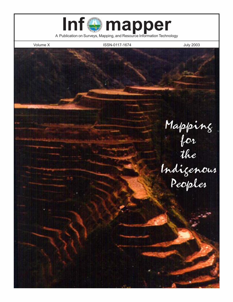
Inf mapper A Publication on Surveys, Mapping, and Resource Information Technology Volume X ISSN-0117-1674 July 2003 Mapping for the Indigenous Peoples
Transcript of Inf mapper - 202.90.149.235202.90.149.235/jdownloads/Info_Mapper/10_im_jul030.pdf · Inf mapper A...
Inf mapperA Publication on Surveys, Mapping, and Resource Information Technology
Volume X ISSN-0117-1674 July 2003
Mappingforthe
IndigenousPeoples
inf mapper
Infomapper
Editorial BoardChairman – Usec. Diony A. Ventura, MNSA · Members – Senior Deputy Administrator Peter N. Tiangco, Ph.D.; Deputy Administrator Ricardo T. Biña; & IMD Director Linda SD. Papa
Editorial StaffExecutive Editor – John SF. Fabic · Editor-in-Chief – Milagros F. Viernes
Managing Editors – Maria Romina dR. Pe Benito & Xenia R. Andres · News Editor – Concepcion A. BringasStaff Writers – Elinor C. delos Reyes, Chester C. Nicolas, Benjamin T. de Leon, George T. Corpuz, & Floyd L. Lopez
Contributors – Randolf S. Vicente (SSD), Rosalino C. delos Reyes (CGSD), Nicandro P. Parayno (MD), Olivia R. Molina (RSRDAD), & Febrina E. Damaso (IMD) · Graphic Arts – Joseph C. Estrella & Sheilah Mae G. LopezPhotography – Nancy M. de Jesus, Renato E. Eguia, Rolando A. Mendoza, Arsenio B. Berriber, & Erlito P. Saberola Editorial Assistants – Julieta C. Palustre, Donnabel R. Reyes, & Rina Grace S. Gatacelo
Published by the Media Production Division, Information Management DepartmentNational Mapping and Resource Information Authority (NAMRIA)
Office: Lawton Avenue, Fort Andres Bonifacio, Makati City·Tel. Nos.: (02) 810-2890; 810-4831 to 36, local 430 Telefax: (02) 810-5466 or 810-5468·E-mail Address: [email protected]
Editorial
2
Editors’ Note: Due to space con-straints, we cannot publish thereferences consulted for the ar-ticles for this issue. Interestedindividuals may avail of the listsfrom the authors. A copy of theoriginal technical paper may like-wise be requested from the au-thor.
Contents
Editorial .................................2
FeaturesThe Importance of ................3Scaling Heights.........................6Indigenous Peoples...................8
News2003 is International Year..........7NAMRIA, FMB in FSIS........12NAMRIA develops.........…..13Most Outstanding...................14Surveying and ..................…..20
Photo Spread .......................10Technical Paper .....…..........15
Cover picture credit: Department ofTourism//Spread design: Nancy M. deJesus & Sheilah Mae G. Lopez
We often read in national dailies storiesthat relate the sorrowful saga of Philippineindigenous peoples in their struggle againstviolations of their human rights: Agta folkin Quezon cry betrayal, Probe of abusesvs. lumads urged, Tribal folks’ rights fallvictim to war vs. communists. Thisstruggle has come a long way and stillhas a long way to go.
In a recent visit to assess the situationconcerning the country’s indigenouspeoples, Professor Rodolfo Stavenhagen,the United Nations (UN) SpecialRapporteur for the Human Rights ofIndigenous Peoples, found out the severityof such transgressions. Notable of hisfindings were accounts of summaryexecutions, rape, and forced recruitmenton account of militarization. Otherinferences from his 11-day mission inDecember last year includedmarginalization, limited access togovernment social services or the justicesystem, low development standards, andterritorial conflicts between developmentprojects and tribal groups.
Bloodthirsty barbarians. Savages.Illiterates. Non-Christians. These are justamong the derogatory names given toindigenous peoples. They are oftentimesthe butt of jokes. Throughout history, theyare the most endangered groups of people.All forms of oppression are inflicted onthem. As results, they are displaced,pushed to the hinterlands, and traded inthe name of development.
Yet, indigenous peoples are an integralpart of our society. Their influence tonational culture is wide-ranging: fromstaple foods to language, and evenmedicines. They play a vital role inretaining and restoring our society’scultural legacy and environment amidstrapid development and modernization.
In December 1994, the InternationalDecade of the World’s Indigenous Peopleswas launched, following the Year of theIndigenous Peoples in 1993. The UNGeneral Assembly committed to improvethe situations of the more than 300 millionindigenous peoples worldwide.Improvements in their condition dependon actions taken on many issues thatconfront them. These issues dwell on landrights; self-government and self-development; resources and environment;culture, language, and education; andhealth and socio-economic conditions.
In the Philippines in 1996, a nationaldecade for the indigenous peoples wasdeclared to call attention to government’ssustained efforts to come up with anational program that will give them duerecognition. The following year, alandmark law was approved to recognize,protect, and promote their rights, and forother purposes. A component of thegovernment’s social reform agenda, thispiece of legislation came to be known asRepublic Act (RA) number 8371 or morepopularly, the Indigenous Peoples’ RightsAct of 1997.
Sought to be recognized, promoted,and protected are the rights of indigenouspeoples to their ancestral domains andlands, self-governance andempowerment, social justice and humanrights, and cultural integrity. Their rightsof ownership and possession to theirancestral domains include the rights to:(1) develop and manage lands and naturalresources, (2) stay in the territories, (3)resettlement in case of displacement, (4)regulate the entry of migrants, (5) claimreservations, (6) safe and clean air andwater, and (7) resolve conflicts thoughcustomary laws.
Squatters no more
...continued on page 14

inf mapper 3
The Importance of Hydrography and Nautical Charting in the Philippinesand its Relation to the UNCLOS
by Lt. (sg) Rosalino C. delos Reyes1
1Senior Hydrographic Engineer and Officer-in-Charge, ENC Development Unit, Hydrographic Survey Division CGSD-NAMRIA
There is an extreme differencebetween delimiting land and waterboundaries. Demarcation of landproperties, boundary negotiations, and allissues related to territorial claim andintegrity can be conceptualized andexamined in an exact location to settledisputes. But in the marine environmentthis is rarely possible. On land, surveymonuments established by means ofconventional and modern methods ofsurveying are enough proof of ownershipand extent of territory. There are alsosupporting documents and legal titlesclearly defining the exact coverage of theproperty. In the marine environment, it isthe combination of either demarcation,delineation or delimitation to establish anddefine a territory.
The Philippine territory is clearlydefined in the Constitutions of 1935,1973, and 1987; the Treaty of Peacebetween the United States and theKingdom of Spain, widely known as theTreaty of Paris in 1898; the United Statesand United Kingdom Treaty in 1930,delimiting the boundary between thePhilippines and the State of North Borneo(Sabah); RA 3046 (1961) as amended byRA 5446 (1968), which defines thebaselines of the Philippines; PresidentialDecree (PD) number 1596, defining theextent and coverage of the Kalayaan IslandGroup (KIG); and PD 1599, defining the200- nautical-mile Exclusive EconomicZone (EEZ).
In addition to the above-mentionedlaws, RA 8550, otherwise known as thePhilippine Fisheries Code of 1998,empowered the local government units todelineate their municipal waters up to the15-kilometer limit from the coastline.Although RA 8550 is not in any way relatedto the UN Convention on the Law of the
Sea (UNCLOS), all of these lawsdemonstrated the current state of thecountry in describing the limits of themarine territory. All laws cited above areexplicitly stated in their proper context andthe medium that is best suited to view thevarious limits defined in these laws isthrough the nautical chart, a product ofhydrography.
Hydrographic Survey of the EEZas Expressed Within the UNCLOS
The UNCLOS can be considered asone of the most important treaties inhistory as it attempts to regulate virtuallyall activities related to the world’s oceans.It took almost over ten years for about150 nations to prepare and consolidate allthe provisions of the UNCLOS,compromising between competing nationswith varied interests, political orotherwise, and producing a carefullycrafted set of guidelines.
NAMRIA through its Coast andGeodetic Survey Department (CGSD) isthe agency of the government responsiblefor hydrographic charting and bathymetricsurveys, portraying these in waysconvenient to the users, traditionally,through the nautical charts andbathymetric maps. Hydrographic surveys,which provide the basic data fornavigational charts formed the initialmarine program of many nations.Hydrography includes the establishmentof shore control stations either by thetraditional conventional survey method orthe state-of-the-art Global PositioningSystem (GPS), the measurement ofdepths, the description of the coastlines,and the study of tides and currents. Inorder to produce a chart of high quality,the standards and specifications set by the
International Hydrographic Organization(IHO) must be satisfied. Hydrography alsoprovides a large part of the informationneeded in maritime boundary delimitationand disputes.
The acquisition of the twomultidisciplinary survey vessels byNAMRIA in the late nineties provided theopportunity for the country to survey itsEEZ and some of the proposed sealanestraversing the archipelago. Relative to therequirement of the UNCLOS to establishand delimit the country’s claim of itsmaritime territory, the data generated inthe hydrographic survey of the Philippinewaters are processed and analyzed for therevision and updating of existing charts.These nautical charts will form part ofseveral documents to be submitted to theUN. As part of the UNCLOS requirement,the Philippines will be responsible inmapping, defining and also designating itsarchipelagic sealanes; and surveying theextent of coverage to ensure the safety ofwatercraft transiting these passages. Allstates party to the UNCLOS will beobliged to establish their respectiveenvironmental and control mechanismsfor efficient and expeditious passage alongtheir waters.
As in the case of the many coastalstates worldwide, the Philippinegovernment will rely mainly on only onegovernment agency, CGSD-NAMRIA,and mostly from the inputs and technicalexpertise of its management teamcomposed mostly of hydrographers,scientists aboard survey ships,oceanographers, geophysicists, and otherkey personnel knowledgeable abouthydrography and oceanography in thepreparation of their territorial claims,according to the UNCLOS requirements.
inf mapper4
These personnel will have to consolidatetheir efforts and knowledge not only onhow to gather, process and analyze thedata but also on how to establish theaccuracy of these measurements. Inaddition, the methods and proceduresundertaken should be properlydocumented and comply with thescientific and technical provisions set forthin the UNCLOS guidelines.
Provisions in the UNCLOS with directrelevance to hydrography are: Part II -Territorial Sea (12 nautical miles from thebaselines) and Contiguous Zone (24nautical miles from the baselines), Part V-Exclusive Economic Zone (200 nauticalmiles from the baselines), Part VI -Continental Shelf, and Annex II -Commission on the Limits of theContinental Shelf. Under Article 48 ofUNCLOS, the breadth of the territorial sea,the contiguous zone, the exclusiveeconomic zone and the continental shelfshall be measured from the archipelagicbaselines drawn in accordance with article47. Under the UNCLOS provision, coastalstates have the right to claim a 12-nautical-mile territorial sea, 24-nautical-milecontiguous zone, and a 200-nautical-mileEEZ. UNCLOS also permits qualifiedcoastal states to claim or submit a claimfor an extended continental shelf up to themaximum limit of 350 nautical miles. Inthe Philippines, NAMRIA is the onlygovernment organization with thecompetence to provide the baselineinformation from which maritimeboundaries are delineated and measuredto establish the sovereignty limits of thecountry. The official publication tocontain such information is the nauticalchart compiled and produced by CGSD.
Portraying the Boundaries
In previous years, the nautical charthas been regarded as just a plain and simplenavigational tool and one of the itemsrequired by the International MaritimeOrganization (IMO) for every vessel tohave aboardship. Nowadays, coastalstates recognize the importance of nauticalcharts as an instrument in the delineationof their coastal boundaries. In Article 5 ofthe UNCLOS, it is very clear that the
official publication that will contain theinformation about the coastal states’territorial sea is the nautical chart. Article5 states: Except where otherwise providedin this Convention, the normal baselinefor measuring the breadth of the territorialsea is the low-water line along the coastas marked on large-scale charts officiallyrecognized by the coastal State. It is furtherexpressed in Article 16, Section 1 and 2which states: The baselines for measuringthe breadth of the territorial seadetermined in accordance with articles 7,9, and 10, or the limits derived therefrom,and the lines of delimitation drawn inaccordance with articles 12 and 15 shallbe shown on charts of a scale or scalesadequate for ascertaining their position.Alternatively, a list of geographicalcoordinates of points, specifying thegeodetic datum, may be substituted. InSection 2, The coastal State shall give duepublicity to such charts or lists ofgeographical coordinates and shalldeposit a copy of such chart or list withthe Secretary General of the UnitedNations.
CGSD is maintaining 178 nauticalcharts and about three-fourths of the totalnumber have already been converted todigital form. The nautical charts producedand published by CGSD are divided intothree groups. These are:
(a) Large-Scale charts intendedfor berthing, approaches to ports and other
areas where navigation is constrained bytraffic density and navigation hazards, andport planning;
(b) Medium-Scale chartsintended for navigation along the coast,route planning, research and cable laying;and
(c) Small-scale charts intendedfor passage planning, research andnavigation in the high seas.
The classification of these nationalchart series is dependent mostly on thearea of coverage, the length of coastlineand the extent and coverage of thecountry’s EEZ. For navigation purposesit is ideal to link the national chart schemeto the international chart scheme in theregion as expressed in certain provisionsof the IHO. The purpose is to ensure thatthe needs of the international shippingcommunity are met by way ofcoordination of the chart schemes ofneighboring countries.
At present, all coastal states aroundthe world rely on the paper chart not onlyfor sea navigation but also to draw anddelineate their boundaries, negotiate withneighboring countries, resolve maritimeboundary disputes, strengthen the positionto claim an extended continental shelf,explore and exploit the marine resources;not to mention other areas such as portconstruction and development, installationand construction of offshore structures,reclamation, fishing, research and
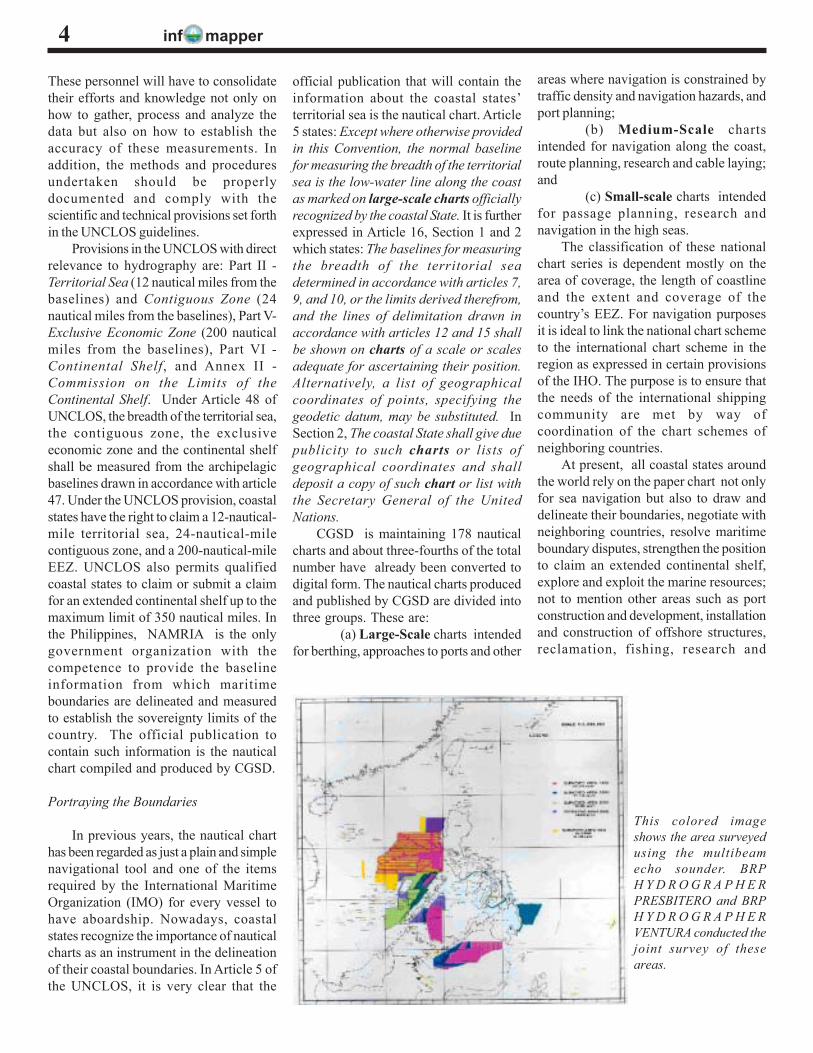
This colored imageshows the area surveyedusing the multibeamecho sounder. BRPH Y D R O G R A P H E RPRESBITERO and BRPH Y D R O G R A P H E RVENTURA conducted thejoint survey of theseareas.
inf mapper 5
development, management andpreservation of coastal areas and fisheryresources, among others. These marine-related activities cannot be undertakenwithout hydrography and the nauticalchart. The Philippines being one of thecoastal states in the region is also relyingon the paper charts compiled andproduced by CGSD. The importance ofhydrography and nautical charting innational development cannot be quantified.Unfortunately, it is lacking in attentionand importance in the highest level ofgovernment.
In the existing chart folio maintainedby CGSD-NAMRIA, there are noboundaries plotted between ourneighboring countries except the linedividing the southern portion of Mindanaoand the State of Borneo which came aboutwhen a treaty was signed between theUnited States of America and the UnitedKingdom in 1930. And notably, the mostfamiliar and widely “accepted” borderenclosing the Philippine Archipelago, theTreaty of Paris limit with designation inthe nautical chart (Chart 4200) as“International Treaty Limit.” The Treatyof Paris was the agreement when theKingdom of Spain ceded control of thePhilippine islands to the Americans in 1898in the amount of $20,000,000.00. ThePhilippines being a party to the UNCLOSconvention should adhere to itsprovisions. A thorough review, however,of our existing laws (RAs, PDs, etc.)including treaties signed by countrieswhich took control of the Philippines inthe early part of the country’s historywould reveal that these laws haveinconsistencies with the provisions of theUNCLOS.
The Challenges Ahead of Us
The Philippines is the eleventh nationto ratify the UNCLOS Convention on 08May 1984. Prior to the ratification andentry into force of the UNCLOSprovisions, many of its aspects havealready been adopted by nations whichsaw the potential and resources of the seaaround their EEZ. Many of thesecountries are now extracting and orlooking for hydrocarbons, solid and liquid
mineral deposits, developing their fishingindustries, building offshore structures,laying underwater cables, and conductingresearch activities to tap the great potentialof the vast oceans. Other countries arenot satisfied with what they have in theirown backyard. Some countries are usingtheir influence to attract other nations toconduct research and inventory ofresources, offering their services toextract the wealth, and in many instancesleaving the less developed country behindwith a small portion of the resources, asin the case of the Philippines.
In the Philippines, there are issuesboth local and international that should beaddressed at the earliest possible time. Themost difficult to solve and the easiest toavoid concerns political, legal, andadministrative issues. The country shouldalso settle several boundary disputes withits neighbors (Malaysia, Japan, Taiwan,Indonesia, etc.) hopefully before thedeadline for submitting a claim set byUNCLOS in May of year 2009. Theseproblems are essential and must beresolved if the country is looking forprogress. CGSD-NAMRIA is playing avery crucial role for the future generationof this country by providing valuableinputs and technical expertise in thepreparation of the requirements forsubmission to the UN.
Racing against Time
The deadline set by UNCLOS for allcoastal States to submit their claim to theUN is May 2009. Coastal states aroundthe world are working round-the-clock tobeat the deadline, even strengthening andexpanding their hydrographic capabilities,acquiring sophisticated equipment,
engaging the services of experts in variousfields. Indonesia embarked on a very bigproject to last about ten years, focusingon their basepoints, baselines,hydrographic surveying, nautical chartingamong others and maybe in a few years’time will be ready to submit their claim tothe UN. They are also eager to settleboundary disputes with their neighbors justto make sure that boundaries betweenadjacent states are properly delineated andreflected on their charts to strengthen theirclaim. Many countries around the worldlike Japan and Australia have createdwithin their hydrographic organization acohesive team whose function is dedicatedto the UNCLOS.
Hydrography and nautical charting areamong the major components in theUNCLOS. However, there are otherimportant aspects included that should beundertaken by the Philippines, like theconduct of seismic, geophysical andgeological studies, baselines andbasepoints determination, among others.A well-coordinated effort is necessary toconduct the studies required and prepareall the documents. Other agencies ofgovernment are very much involved in thisundertaking.
Strong support from the House ofRepresentatives, the Senate, and the Officeof the President is needed. Our ownidentity as a nation, our sovereignty, andthe future of our generation is at stakehere. The time is now to focus ourattention on the ocean and the seas wherea huge part of our wealth and resourcesare waiting to be explored and exploited.
The big question is, WHERE AREWE NOW?·
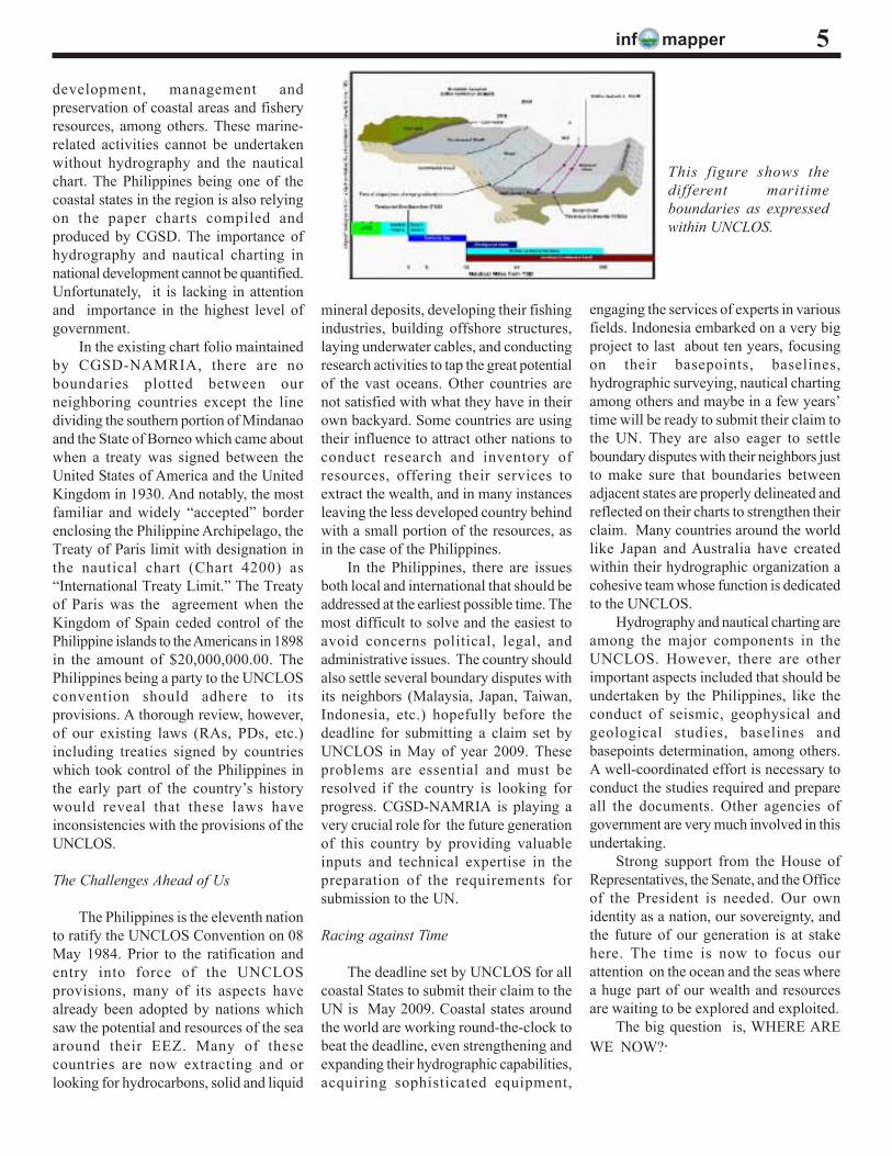
This figure shows thedifferent maritimeboundaries as expressedwithin UNCLOS.
inf mapper
1With inputs from Ms. Concepcion A. Bringas, head of the NAMRIA IEC component, and other team members: Renato E. Eguia,Joseph C. Estrella, Chester C. Nicolas, Benjamin T. de Leon, Rolando A. Mendoza, Floyd L. Lopez, Erlito P. Saberola, Arsenio B.Berriber, and Sheilah Mae G. Lopez.
6
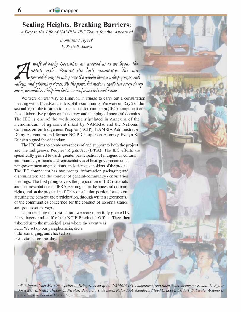
A waft of early December air greeted us as we began theuphill scale. Behind the lush mountains, the sunpressed its rays to splay over the golden terraces, deep gorges, rich
valleys, and glistening rivers. As the powerful motor negotiated every sharpcurve, we could not help but feel a sense of awe and timelessness.
Scaling Heights, Breaking Barriers:A Day in the Life of NAMRIA IEC Teams for the Ancestral
Domains Project1
by Xenia R. Andres
We were on our way to Hingyon in Ifugao to carry out a consultationmeeting with officials and elders of the community. We were on Day 2 of thesecond leg of the information and education campaign (IEC) component ofthe collaborative project on the survey and mapping of ancestral domains.The IEC is one of the work scopes stipulated in Annex A of thememorandum of agreement inked by NAMRIA and the NationalCommission on Indigenous Peoples (NCIP). NAMRIA AdministratorDiony A. Ventura and former NCIP Chairperson Attorney Evelyn S.Dunuan signed the addendum.
The IEC aims to create awareness of and support to both the projectand the Indigenous Peoples’ Rights Act (IPRA). The IEC efforts arespecifically geared towards greater participation of indigenous culturalcommunities, officials and representatives of local government units,non-government organizations, and other stakeholders of the project.The IEC component has two prongs: information packaging anddissemination and the conduct of general/community consultationmeetings. The first prong covers the preparation of IEC materialsand the presentations on IPRA, zeroing in on the ancestral domainrights, and on the project itself. The consultation portion focuses onsecuring the consent and participation, through written agreements,of the communities concerned for the conduct of reconnaissanceand perimeter surveys.
Upon reaching our destination, we were cheerfully greeted bythe villagers and staff of the NCIP Provincial Office. They thenushered us to the municipal gym where the event washeld. We set up our paraphernalia, did alittle rearranging, and checked onthe details for the day.
inf mapper 7Pretty soon, the participants andconcerned parties started to arrive andmill around the venue. Registrationactivities ensued while local music wasplayed over the karaoke. After a while,the camera recorder began to roll andthe still camera clicked away. Theprogram was ready in 3…2…1.
The invocation and singing of thenational anthem was followed with awelcome talk by the municipal vicemayor, Honorable Aquilino C. Namingit.Preceding the consultation and openforum were presentations on the IPRAand claims-conversion processes. NCIPProvincial Officer Fernando D. BahatanJr. served as the resource person. Theproject was well received by thecommunity. They were very optimisticabout it. As one IEC team memberexpressed, the project “was not onlytimely but necessary to put in order thecontroversies that have long beenneglected in the dustbin of history. Suchdebates spawned animosities andconflicts regarding ancestral domainclaims.”
Prior to this activity, a larger IEC andconsultation meeting regarding the
2003 is International Year of Freshwaterby Rijaldia N. Santos1
The UN General Assembly proclaimed2003 as the International Year ofFreshwater (IYF). The proclamationseeks to increase awareness of theimportance of freshwater, its sustainableuse, management, and protection.
In the Philippines, IYF was launchedlast March 25 at the Ninoy Aquino Parksand Wildlife Nature Center in Quezon City.Environment Sec. Elisea G. Gozun ledthe celebration and stressed the need toprotect our watershed areas, lakes, rivers,estuaries, wetlands, streams, undergroundaquifers, and groundwater. Amemorandum of understanding wassigned during the launching for thecreation of a national technical workinggroup on Philippine lakes.
survey and mapping of KianganAncestral Domain or CADC 046 wereconducted at the Lagawe Central Schoolon 17-19 November 2002. The programstructure was similar except for theconsultation part wherein five clustersof municipalities adjoining Kiangan wereformed. The groups included Lamut,Lagawe-Hingyon, Asipulo, Hungduan,and Tinoc. The clustering sought to: (1)obtain the consent of the concernedparties to allow the NAMRIA teams toconduct consultation, ground control, andperimeter surveys in their respectiveareas; (2) determine the properauthorities, i.e., local officials andrepresentatives of the council of elderswho shall agree on the boundaries; (3)set the schedule for the consultation andGPS surveys in the localities; and (4)discuss and resolve related issues. Thetechnical staff of NAMRIA and NCIPserved as group facilitators.
The project was in the same wayembraced by the participants andstakeholders during the general IEC.They showed their keen interest byparticipating vibrantly during thediscussions. As described by the head
of the IEC component, the people “wereauthentic, accommodating, and open topossibilities, yet uncompromising of theirancestral land claims.”
The success of the Lagawe eventsignaled the start of communityconsultations. That is why we set out atonce on 03 December 2002. Our firststop was Lamut.
After the thorough communitydeliberations and with the necessarydocuments in place, we packed up ourthings, extended our sincere thanks, andsadly bid adieu. Soon we would beleaving for Manila. But our journey wasnot about to end. The third team wasalready upbeat on their IEC swing inKiangan on 08 December 2002.
The IEC proved to be a dauntingtask, mainly in coordination. “It waschallenging, especially since the people’ssocio-cultural values differ from ours. Ihad to constantly accustom myself withthe place I was in and the people I wasdealing with in order to achievediplomacy and eventually pursue thegoals of our undertaking,” said our IEChead. “Overall, it was a learningexperience for us.” ·
The DENR and the Department ofAgriculture (DA) embarked on a five-yearprogram to preserve the country’s criticalwatershed areas that support irrigationsystems and are vital sources offreshwater as well.
The DENR-DA tandem hasformulated a P2.85-billion WatershedManagement Program, in coordinationwith the National Irrigation Administration(NIA), to address problems of degradationon watersheds, extend the useful life ofNIA irrigation systems, and improve wateryields. The program also incorporateslivelihood opportunities for watershedresidents.
NIA has identified some 136watersheds in the Philippines as already
in critical condition. This covers some4.5 million hectares and is home to about6.88 million Filipinos or 9 percent of thenational population.
From March 24-27, the Philippinesalso hosted the second InternationalTropical Marine Ecosystems ManagementSymposium, bringing togethergovernment representatives, coastalmanagers, and decision makers from over40 countries to discuss priority issues andgaps in coastal management.
Last April, Secretary Gozun led thePhilippine delegation in Kyoto, Japan fora week-long Third World Water Forum.The World Water Council and the UNsponsored the forum. ·
1Chief, Physiography and Aquatics Division, Remote Sensing and Resource Data Analysis Department (RSRDAD)
inf mapper
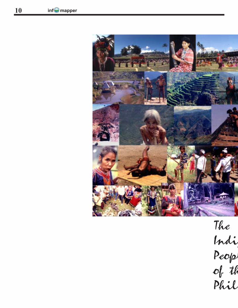
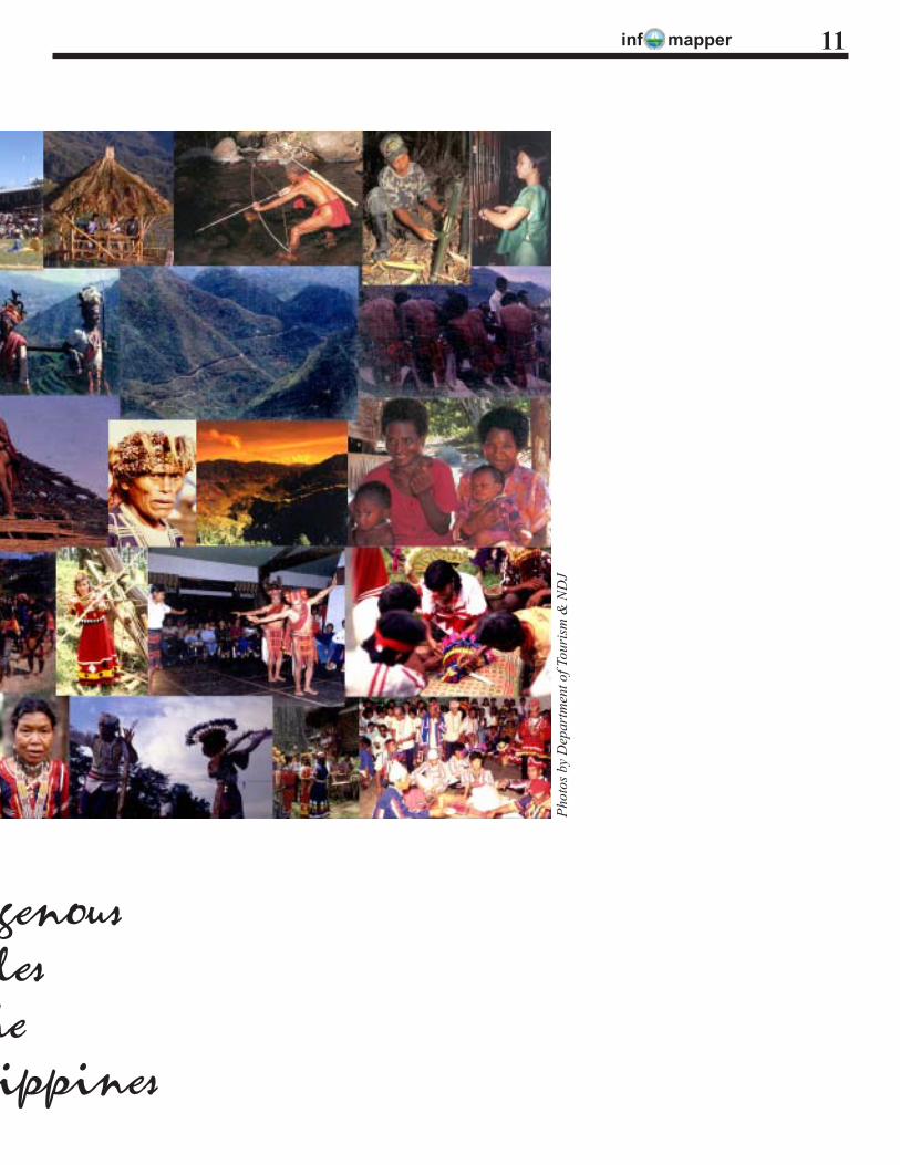
Indigenous Peoples… Indigenous Filipinos!by Maria Romina dR. Pe Benito
There was the land to begin with andwith the land were the people. Who werethey? In our ancient times, the aborigi-nes of our nation, the original settlers,peopled the archipelago. They make upour ancestors.
Their descendants are the nativebrothers and sisters whom we have cometo know through generations and undervarious names. Presently they are knownas the indigenous peoples of the Philip-pines, as recognized by the UN. We willattempt to make a profile of them here,using invaluable sources of knowledgeabout them, such as information materi-als from the NCIP.
Roots Diversified
According to the Filipino anthropolo-gist, F. Landa Jocano,1 our forebearswere part of “a common population withthe same base culture,” to which belonged“the peoples of prehistoric Island South-east Asia.” Furthermore, variations to thiscore population came about through hu-man evolution and movements.
In the case of the archipelago, therewere the immigrants from neighboringcountries of Asia such as China, Indone-sia, and Malaysia. Other than those pur-posely seeking a new place of settlement,“immigrants” would also include thosewho came in as merchants, missionar-ies, teachers, or just plain adventurers anddecided to remain.
Thus various groups of people werefirst encountered by the Spaniards, theacknowledged discoverer of the archi-pelago through Ferdinand Magellan. Inthe “History of the Filipino People” bookof Teodoro A. Agoncillo, it is said that “onthe eve of the coming of the Spaniards”there existed “multiple ethnolinguisticgroups, mostly animistic, and in the south,Islamized.” Historian William Henry Scott
also has this account in an article:When the Spaniards arrived in the
Philippines, they found the Filipinopeople divided . . . into a large number ofgroups, each speaking a different lan-guage. Their local customs varied fromplace to place, . . .
The identity of pre-colonial Filipinos,as seen in their customs, modes of liv-ing, and traditions, was very much pre-served. It certainly took a great deal oftheir tenacity to be able to resist subju-gation and change especially with the pres-ence of foreign conquerors who stayedfor centuries.
The Tribes
There are a total of 110 indigenousethnolinguistic groups in the Philippines.Several communities are classified intoeach of the following major tribal groups:the Negrito group, the Mangyans ofMindoro, and the Lumads of Mindanao.Other major groups are named after theplaces inhabited by the communities suchas the peoples of Caraballo and Cordil-lera, mountain ranges respectively ofCentral and Northern Luzon; and thePalawan hilltribes. Then there is theMuslim group in Mindanao and Palawanwhere there are about 13 ethnolinguisticgroups.
Most tribes practice self-governanceand subsist on farming of rice and rootcrops, fishing, hunting wild game, andgathering of forest products. These aresupplemented by livestock and poultryraising and doing menial work for land-lords.
Distinct, homogenous groups havesimilarities in terms of arts, costumes,folklore, houses, languages, practices,rituals, and religious beliefs. This even ifsome may live far apart from one another.Subtle differences say in dialects and oral
traditions account for the presence of sub-groups for major groups.
The archipelago is made unique ow-ing to the kaleidoscope of its various lo-cal cultures. Foreign tourists are especiallyappreciative of the indigenous peoples:their customs, lifestyle, and traditions;their artifacts, festive dances, musical in-struments, and native costumes and in-dustries. The archipelago is home to theworld-famous, ingeniously made rice ter-races in Banawe of the Ifugaos.
Driven into the Hinterlands
In ancient times, new visitors to thearchipelago with the intention to staysettled down in whichever vacant partthey wanted to make their home. If oc-cupied, they did so in peaceful co-exist-ence with the resident owners. It alsohappened that they themselves eased theold residents out as in the case of the Atigroup of Panay Island who were con-vinced to sell their land to the newcom-ers, the Bornean datus led by their leader,Datu Puti.
The Wave Migration Theory, suppos-edly of and widely propagated by theAmerican colonizers according to Scott,puts things quite severely. It is about thepeopling of the Philippines “by a series ofwaves of migrants, each of which wassuperior to the ones that preceded it.” Themindset brought about by this theory canhelp explain whatever existing prejudices,sentiments or acts of discriminationagainst indigenous peoples, which in turnlead to their oppression and exploitation.
The “driving off” aspect of the mi-gration process is put this way in old ba-sic Philippine history books such as thatof Dr. Gregorio F. Zaide: “They [the In-donesians] drove the Pygmies into themountains and occupied the lowlands.”Then later, “. . . . they [the Malays] drove
1As cited in Agoncillo, T. A., 1990. History of the Filipino People, GAROTECH Publishing, Quezon City, pp.21-22.
8
inf mapper
the Indonesians into the forests and settledin the lowlands.”
Indigenous peoples are generallyknown to live in the remote rural areas.Our ancestors did so not just becausethey were foremost lovers of nature. Theirself-imposed living in isolation was alsodone to avoid the particularly strong trans-forming influences of certain alien cul-tures. Cases in point are the “Sword andthe Cross” strategy (i.e., by force andconversion to Christianity) of the Span-iards and later the “Benevolent Assimila-tion” policy of the Americans which bothfailed to break the strong resistance ofmost indigenous peoples to change.
To live in the hinterlands would meanto be isolated from or deprived of the fore-most benefit of modern civilization whichis socio-economic development. Indig-enous peoples generally managed to sur-vive in the past despite whatever were thelimitations. Nevertheless, through theyears there were families who migratedto other places for better economic op-portunities. In joining the mainstream, soto speak, such as living and working inthe lowland areas for their keep, some al-lowed themselves to be assimilated intothe new culture.
Being simple people with basic needs,many indigenous peoples would generallyhave managed to thrive independently inplaces where they could do so, freely.Grave conditions and events of moderntimes, however, eventually caught up withthem. It was and continuous to be proventhat the resulting displacement or forcedevacuation leads to poverty andmarginalization, especially if left un-checked.
A case in point is the prolonged armedconflict in Mindanao, more recent epi-sodes of which have displaced hundredsof families from their homes. Those al-ready traumatized by war still have to dealwith the deprived conditions in evacua-tion centers: hunger, discomfort, despair,the possibility of disease or even of death.
Indigenous peoples who suffered dis-location so many times in their history arethe Negritos. From mostly living in theplains/lowlands to withdrawing to themountains or wherever in the interior ar-eas they could settle, many became no-
mads with the intrusion of the likes of log-ging concessionaires, miners, and evenof other displaced groups. This is alsobecause of the construction of govern-ment infrastructure projects in their ar-eas, and of military operations out to flushout insurgents. Later descendants have hadto deal with further incidences of evic-tion or of fruitless legal battles to deal withclaimants. The 1991 volcanic eruptionsof Mt. Pinatubo caused the displacementof hundreds of families who lived in itsvicinity.
Outcasts in Their Own Territory
Valued greatly was the land which wastilled for food and where stood the shel-ter of the first family that lived there, theearliest members of the tribal race. Therefamilial bonds took root and were nour-ished with the love, concern, and respectmembers had for one another. The landwas the common property of all the mem-bers. The cycle would forever repeat it-self for all generations to come. The headof the family decreed it to be so. With thecoming of other residents and the settingup of a community or tribe headed by thechieftains there were then communally-defined territorial limits for the livingspaces of respective families.
The tribe had their rights over theircommunal land which they vowed to up-hold no matter what. The “no matterwhat” were the efforts of those out toevict them for reasons of progress or sim-ply of greed, with weak or no recognitionof whatever their rights or claims.
Much as the tribes would want tofunction independently, they would still besubject to the laws of the ruling, non-in-digenous majority. The focus of govern-ment on indigenous peoples shiftedthrough the years. This, from the objec-tive of seeking their integration into themainstream population, as was the func-tion of the American regime’s Bureau ofNon-Christian Tribes, to that of protect-ing and promoting “the interest and well-being of the indigenous peoples with dueregard to their beliefs, customs, traditionsand institutions,“ the mandate of the NCIP.
In recent years, the governmentthrough the Department of Environment
and Natural Resources (DENR), was ableto ease somewhat the long struggle of theindigenous peoples to keep or recover theirbirthright to their ancestral domain throughthe issuance of the Certificate of Ances-tral Domain Claim (CADC) to empowerholders “to manage and exploit the re-sources found within their domains inaccordance with existing laws, to plan theirown future and to gain access to adequatebasic services. The CADC was a provi-sional measure prior to the passage of theIndigenous Peoples Rights Act of 1997or Republic Act number 8371. The lawwhich created the NCIP is for the recog-nition, promotion, and protection of,among others, the right of the indigenouspeoples to ancestral domains.
Among the tasks of the NCIP atpresent is the issuance and conversionfrom the CADC of the Certificate of An-cestral Domain Title (CADT). The CADTsignifies ownership by the tribe of itsancestral domain. With NAMRIA, theNCIP is undertaking the survey and map-ping of ancestral domains for sustainableland use and management.
The Filipino Defined
The scattered islands of the archi-pelago was named after a foreign rulerand became the country known as thePhilippines, and its people with many di-verse cultures carried the name Filipinos.
The Filipino is a mixture of races.Perhaps in being less conscious of dis-tinctions, there can be a totality of partsand in the psyche can be extinguishedlong-existing conditions or connotationsassociated with certain labels: Christian,Western, superior— on one hand; indio,non-Christian, pygmy, infidel, pagan, sav-age, non-superior— on the other. Indig-enous and non-indigenous peoples liveon the same archipelago, the same coun-try and both deserve respect and recog-nition. Indigenous peoples are Filipinos.Someday perhaps the struggle for mostof them will cease. ·
9
inf mapper
TheIndigPeoplof thPhili
10
inf mapper
Phot
os b
y D
epar
tmen
t of T
ouri
sm &
ND
J
genouslesheippines
11
inf mapper12
NAMRIA, FMB in FSIS project (phase 1)by George T. Corpuz
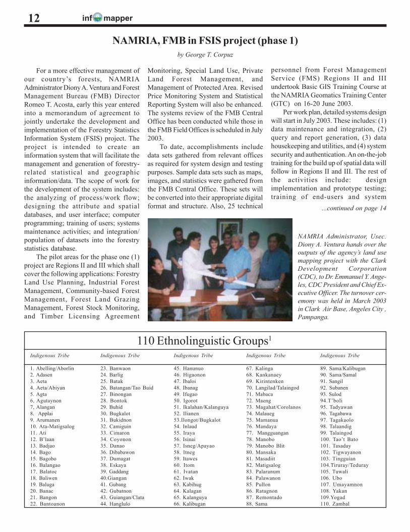
NAMRIA Administrator, Usec.Diony A. Ventura hands over theoutputs of the agency’s land usemapping project with the ClarkDevelopment Corporation(CDC), to Dr. Emmanuel Y. Ange-les, CDC President and Chief Ex-ecutive Officer. The turnover cer-emony was held in March 2003in Clark Air Base, Angeles City ,Pampanga.
Indigenous Tribe
89. Sama/Kalibugan90. Sama/Samal91. Sangil92. Subanen93. Sulod94.T’boli95. Tadyawan96. Tagabawa97. Tagakaolo98. Talaandig99. Talaingod100. Tao’t Bato101. Tasaday102. Tigwayanon103. Tingguian104.Tiruray/Teduray105. Tuwali106. Ubo107. Umayamnon108. Yakan109.Yogad110. Zambal
110 Ethnolinguistic Groups1
Indigenous Tribe
1. Abelling/Aborlin2. Adasen3. Aeta4. Aeta/Abiyan5. Agta6, Agutaynon7, Alangan8. Applai9. Arumanen10. Ata-Matigsalog11. Ati12. B’laan13. Badjao14. Bago15. Bagobo16. Balangao17. Balatoc18. Baliwen19. Baluga20. Banac21. Bangon22. Bantoanon
Indigenous Tribe
23. Banwaon24. Barlig25. Batak26. Batangan/Tao Buid27. Binongan28. Bontok29. Buhid30. Bugkalot31. Bukidnon32. Camiguin33. Cimaron34. Coyonon35. Danao36. Dibabawon37. Dumagat38. Eskaya39. Gaddang40.Giangan41. Gubang42. Gubatnon43. Guiangan/Clata44. Hanglulo
Indigenous Tribe
45. Hanunuo46. Higaonon47. Ibaloi48. Ibanag49. Ifugao50. Igorot51. Ikalahan/Kalanguya52. Ilianen53.Ilongot/Bugkalot54. Inlaud55. Iraya56. Isinai57. Isneg/Apayao58. Itneg59. Itawes60. Itom61. Ivatan62. Iwak63. Kabihug64. Kalagan65. Kalanguya66. Kalibugan
Indigenous Tribe
67. Kalinga68. Kankanaey69. Kirintenken70. Langilad/Talaingod71. Mabaca72. Maeng73. Magahat/Corolanos74. Malaueg75. Mamanua76. Mandaya77. Mangguangan78. Manobo79. Manobo Blit80. Mansaka81. Masadiit82. Matigsalog83. Palaranum84. Palawanon85. Pullon86. Ratagnon87. Remontado88. Sama
...continued on page 14
For a more effective management ofour country’s forests, NAMRIAAdministrator Diony A. Ventura and ForestManagement Bureau (FMB) DirectorRomeo T. Acosta, early this year enteredinto a memorandum of agreement tojointly undertake the development andimplementation of the Forestry StatisticsInformation System (FSIS) project. Theproject is intended to create aninformation system that will facilitate themanagement and generation of forestry-related statistical and geographicinformation/data. The scope of work forthe development of the system includes:the analyzing of process/work flow;designing the attribute and spatialdatabases, and user interface; computerprogramming; training of users; systemsmaintenance activities; and integration/population of datasets into the forestrystatistics database.
The pilot areas for the phase one (1)project are Regions II and III which shallcover the following applications: ForestryLand Use Planning, Industrial ForestManagement, Community-based ForestManagement, Forest Land GrazingManagement, Forest Stock Monitoring,and Timber Licensing Agreement
Monitoring, Special Land Use, PrivateLand Forest Management, andManagement of Protected Area. RevisedPrice Monitoring System and StatisticalReporting System will also be enhanced.The systems review of the FMB CentralOffice has been conducted while those inthe FMB Field Offices is scheduled in July2003.
To date, accomplishments includedata sets gathered from relevant officesas required for system design and testingpurposes. Sample data sets such as maps,images, and statistics were gathered fromthe FMB Central Office. These sets willbe converted into their appropriate digitalformat and structure. Also, 25 technical
personnel from Forest ManagementService (FMS) Regions II and IIIundertook Basic GIS Training Course atthe NAMRIA Geomatics Training Center(GTC) on 16-20 June 2003.
Per work plan, detailed systems designwill start in July 2003. These includes: (1)data maintenance and integration, (2)query and report generation, (3) datahousekeeping and utilities, and (4) systemsecurity and authentication. An on-the-jobtraining for the build up of spatial data willfollow in Regions II and III. The rest ofthe activities include: designimplementation and prototype testing;training of end-users and system
inf mapper
News
13
NAMRIA and the PhilippineAtmospheric, Geophysical, andAstronomical Services Administration(PAGASA) are undertaking a project onthe development of a GIS-based ClimateInformation System focusing on rainfallanalysis to meet the weather informationneeds of the farmers and the agriculturalsector.
The project is envisioned to providetimely and reliable forecasts and advisorieson extreme weather and climateconditions, a critical function of PAGASA.The project started in July 2002 and isexpected to be completed in June 2003.
The strategic objectives of the projectare as follows: (1) the establishment ofthe GIS-facilities that will manage thedeveloped system; (2) the development ofthe required database to develop theenvisioned GIS-based system; and (3)the provision of training covering bothformal (lectures/hands-on) and non-formal (on-the-job) training courses onGIS. The acquisition and installation ofthe basic hardware and software werecompleted within the first three monthsof the project implementation.Development of the databank is going onfull swing with the completion of the1:250,000 map-sheet-based 100 meter-contour interval expected in June.Training courses have been scheduledjudiciously to coincide with the differentproject development phases.
The training component includes notjust the GIS technology but also coversaffiliated technologies which will make theagency competent in managing andmaintaining the GIS-based ClimateInformation System. Training coursescovering the GIS concepts, usage, andother components were held fromSeptember to November 2002; while
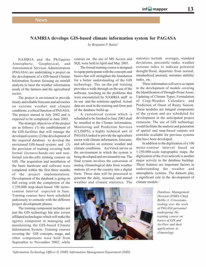
NAMRIA develops GIS-based climate information system for PAGASAby Benjamin P. Balais1
courses on the use of MS Access andSQL were held in April and May 2003.
The formal training course is designedto equip participants with the concepts andbasics that will strengthen the foundationfor a better understanding of the GIStechnology. The on-the-job trainingprovides a walk-through on the use of thesoftware, touching on the problems thatwere encountered by NAMRIA staff inits use and the solutions applied. Actualdata are used in the training and form partof the database build-up.
A customized system which isscheduled to be finished in June 2003 shallbe installed at the Climate Information,Monitoring and Prediction Services(CLIMPS), a highly technical unit ofPAGASA tasked to provide the agriculturesector with climate information, forecasts,and advisories on extreme weather andclimate conditions. ArcViewâ serves asthe environment in which the system isbeing developed and envisioned to run. Thefinal system involves the conversion ofanalog climatological data from weatherstations all over the country into a digitalform. These data will be processed togenerate the daily, seasonal, and annualweather and climate statistics. The
1Information Technology Officer II, DMD, Information Management Department (IMD)
Database ManagementDivision (DMD) Chief,Bobby A. Crisostomo,looking over the workof PAGASA personnelundergoing thetraining course onbasics of GIS andArcView and theirapplications toclimatology
statistics include averages, standarddeviations, percentile ranks, weatherextreme index to indicate potentialdrought/flood, departure from normal,standardized anomaly, moisture stabilityindex, etc.
These information will serve as inputsto the development of models coveringthe Identification of Drought-Prone Areas;Updating of Climate Types; Formulationof Crop-Weather Calendars; andPrediction of Onset of Rainy Season.These modules are integral componentsof the system and are scheduled fordevelopment in the anticipated projectextension. The use of GIS technologywould facilitate the analysis and generationof spatial and map-based outputs noterstwhile available for previous systemsthat have been developed.
In addition to the digitization of a 100meter-contour interval based on1:250,000-scale topographic maps, thedigitization of the river network is anothermajor activity in the database buildup.These features are important factors inunderstanding the weather andatmospheric systems. The datasets playa significant role in the development ofclimate models. ·
inf mapper14
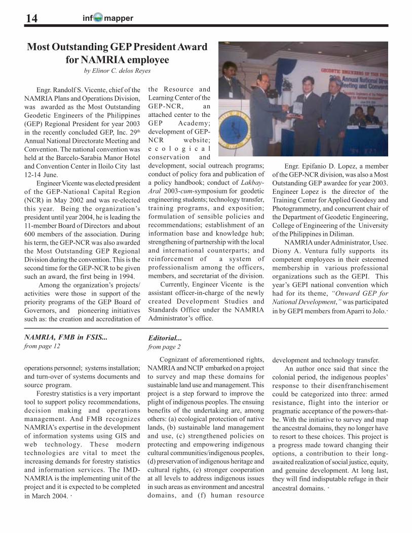
Engr. Randolf S. Vicente, chief of theNAMRIA Plans and Operations Division,was awarded as the Most OutstandingGeodetic Engineers of the Philippines(GEP) Regional President for year 2003in the recently concluded GEP, Inc. 29th
Annual National Directorate Meeting andConvention. The national convention washeld at the Barcelo-Sarabia Manor Hoteland Convention Center in Iloilo City last12-14 June.
Engineer Vicente was elected presidentof the GEP-National Capital Region(NCR) in May 2002 and was re-electedthis year. Being the organization’spresident until year 2004, he is leading the11-member Board of Directors and about600 members of the association. Duringhis term, the GEP-NCR was also awardedthe Most Outstanding GEP RegionalDivision during the convention. This is thesecond time for the GEP-NCR to be givensuch an award, the first being in 1994.
Among the organization’s projects/activities were those in support of thepriority programs of the GEP Board ofGovernors, and pioneering initiativessuch as: the creation and accreditation of
Most Outstanding GEP President Awardfor NAMRIA employee
by Elinor C. delos Reyes
the Resource andLearning Center of theGEP-NCR, anattached center to theGEP Academy;development of GEP-NCR website;e c o l o g i c a lconservation anddevelopment, social outreach programs;conduct of policy fora and publication ofa policy handbook; conduct of Lakbay-Aral 2003-cum-symposium for geodeticengineering students; technology transfer,training programs, and exposition;formulation of sensible policies andrecommendations; establishment of aninformation base and knowledge hub;strengthening of partnership with the localand international counterparts; andreinforcement of a system ofprofessionalism among the officers,members, and secretariat of the division.
Currently, Engineer Vicente is theassistant officer-in-charge of the newlycreated Development Studies andStandards Office under the NAMRIAAdministrator’s office.
Engr. Epifanio D. Lopez, a memberof the GEP-NCR division, was also a MostOutstanding GEP awardee for year 2003.Engineer Lopez is the director of theTraining Center for Applied Geodesy andPhotogrammetry, and concurrent chair ofthe Department of Geodetic Engineering,College of Engineering of the Universityof the Philippines in Diliman.
NAMRIA under Administrator, Usec.Diony A. Ventura fully supports itscompetent employees in their esteemedmembership in various professionalorganizations such as the GEPI. Thisyear’s GEPI national convention whichhad for its theme, “Onward GEP forNational Development,” was participatedin by GEPI members from Aparri to Jolo.·
NAMRIA, FMB in FSIS...from page 12
operations personnel; systems installation;and turn-over of systems documents andsource program.
Forestry statistics is a very importanttool to support policy recommendations,decision making and operationsmanagement. And FMB recognizesNAMRIA’s expertise in the developmentof information systems using GIS andweb technology. These moderntechnologies are vital to meet theincreasing demands for forestry statisticsand information services. The IMD-NAMRIA is the implementing unit of theproject and it is expected to be completedin March 2004. ·
Cognizant of aforementioned rights,NAMRIA and NCIP embarked on a projectto survey and map these domains forsustainable land use and management. Thisproject is a step forward to improve theplight of indigenous peoples. The ensuingbenefits of the undertaking are, amongothers: (a) ecological protection of nativelands, (b) sustainable land managementand use, (c) strengthened policies onprotecting and empowering indigenouscultural communities/indigenous peoples,(d) preservation of indigenous heritage andcultural rights, (e) stronger cooperationat all levels to address indigenous issuesin such areas as environment and ancestraldomains, and (f) human resource
development and technology transfer.An author once said that since the
colonial period, the indigenous peoples’response to their disenfranchisementcould be categorized into three: armedresistance, flight into the interior orpragmatic acceptance of the powers-that-be. With the initiative to survey and mapthe ancestral domains, they no longer haveto resort to these choices. This project isa progress made toward changing theiroptions, a contribution to their long-awaited realization of social justice, equity,and genuine development. At long last,they will find indisputable refuge in theirancestral domains. ·
Editorial...from page 2
inf mapper 15
I. Introduction
The primary base maps for thePhilippines produced by NAMRIA areat scales 1:50,000 and 1:250,000. Thelatter smaller-scale maps are derivedfrom the larger-scale series. At present,these conventional topographic basemaps are outdated but users have tocontend with available existing maps.Urban centers that are potentials ofgrowth and economic expansion arecovered with base maps that have notbeen updated.
During the past decade, developmentactivities on areas specifically alongcoastal regions have rapidly increased.Prime agricultural lands are beingconverted to industrial and residentialuse. Heavy influx of population and rapidurban growth is also threatening itsresources. With these dilemmas, thereis an urgent need to update the mapscovering this region considering thechanges that have occurred on the landfeatures. It is a worrying trend whenbase maps are not updated since itimplies that the mapping activitiesfundamental to a country’s developmentmay not be taking place (Davis andFairbairn, 1998). Frequent updatingshould help lessen the more difficult andcostly process that may accumulate inthe long run. Local governmentauthorities, planners and decision-makers will benefit from the new land
Integrated Techniques for Base Map Updatingby Nicandro P. Parayno1
cover information in the revised maps.A developing country like the
Philippines experiences a situation whereit has to be up-to-date with newtechnologies and developments to solvepresent problems. This is evident in thefield of map production. New concepts,ideas, procedures and technologies helpmapping agencies like NAMRIA tosatisfy the ever growing demands for up-to-date maps and the changingrequirements of geo-information users.A proper integration and adaptation ofnew technologies into the digitalenvironment has to be undertaken toovercome problems of efficiency andeffectiveness (i.e., maximizing the useof geographic data, equipment, andpersonnel).
II. The Study Area
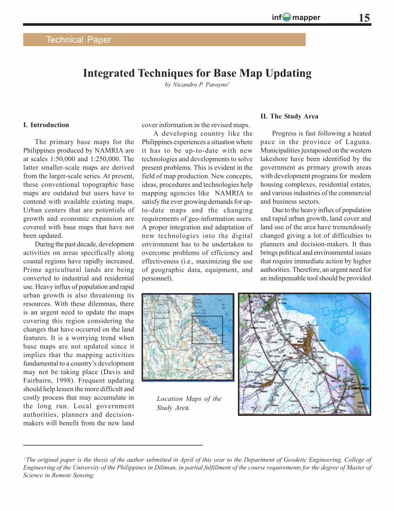
Progress is fast following a heatedpace in the province of Laguna.Municipalities juxtaposed on the westernlakeshore have been identified by thegovernment as primary growth areaswith development programs for modernhousing complexes, residential estates,and various industries of the commercialand business sectors.
Due to the heavy influx of populationand rapid urban growth, land cover andland use of the area have tremendouslychanged giving a lot of difficulties toplanners and decision-makers. It thusbrings political and environmental issuesthat require immediate action by higherauthorities. Therefore, an urgent need foran indispensable tool should be provided
Location Maps of theStudy Area
1The original paper is the thesis of the author submitted in April of this year to the Department of Geodetic Engineering, College ofEngineering of the University of the Philippines in Diliman, in partial fulfillment of the course requirements for the degree of Master ofScience in Remote Sensing.
Technical Paper
inf mapper16
to the authorities concerned and updatethe latest land information by carefullyplanning the economic indicators such asroad network, infrastructure, and otherplanning parameters.
The current technology used forbase map updating is time-consuming,costly, and labor-intensive. This consistsof aerial photography, establishment ofphoto control points by ground surveys,stereo-compilation, field verification, andcartographic enhancement. Hence, onlya small percentage of the 642 sheets of1:50,000 base maps have been completelyor partially revised.
Aerial photography is necessarilyundertaken to have a data source for thearea to be mapped. Photo-control surveyfor establishing position of points usingthe global positioning system is an activitybeing undertaken by CGSD-NAMRIA.Stereo compilation or data capturing ofline features from aerial photographs isa photogrammetric activity that usuallycomprises the major portion of the mapproduction and revision process. In orderto produce a single medium-scale basemap at scale 1:50,000; 25 map sheets atscale 1:10,000 with a geographic formatof 3’ x 3’ will be needed. Utilizing thepresent hardware and software installedand the production capability of theNAMRIA Mapping Department, about55 topographic base maps at scale1:10,000 can be produced in one year.This, however, does not include fieldverification and cartographicenhancement activities. With thisconventional technology, only two (2)sheets for 1:50,000 map series can beproduced or completely revised in oneyear.
III. General Objective
After more than twelve years sincethe creation of NAMRIA, only about30% of the entire land area of thecountry has updated 1:50,000-scalemaps. Some of these maps were revisedthrough foreign-assisted projects.
The study aims to integrate satelliteremote sensing and digital
photogrammetric techniques in updatinglarge and medium-scale base mapsparticularly the planimetric informationin areas that have strong potentials forurban growth. The new base map of thestudy area will be stored in a digital formatand will serve as a cartographic modelfor frequent revision processes.
IV. Methodology
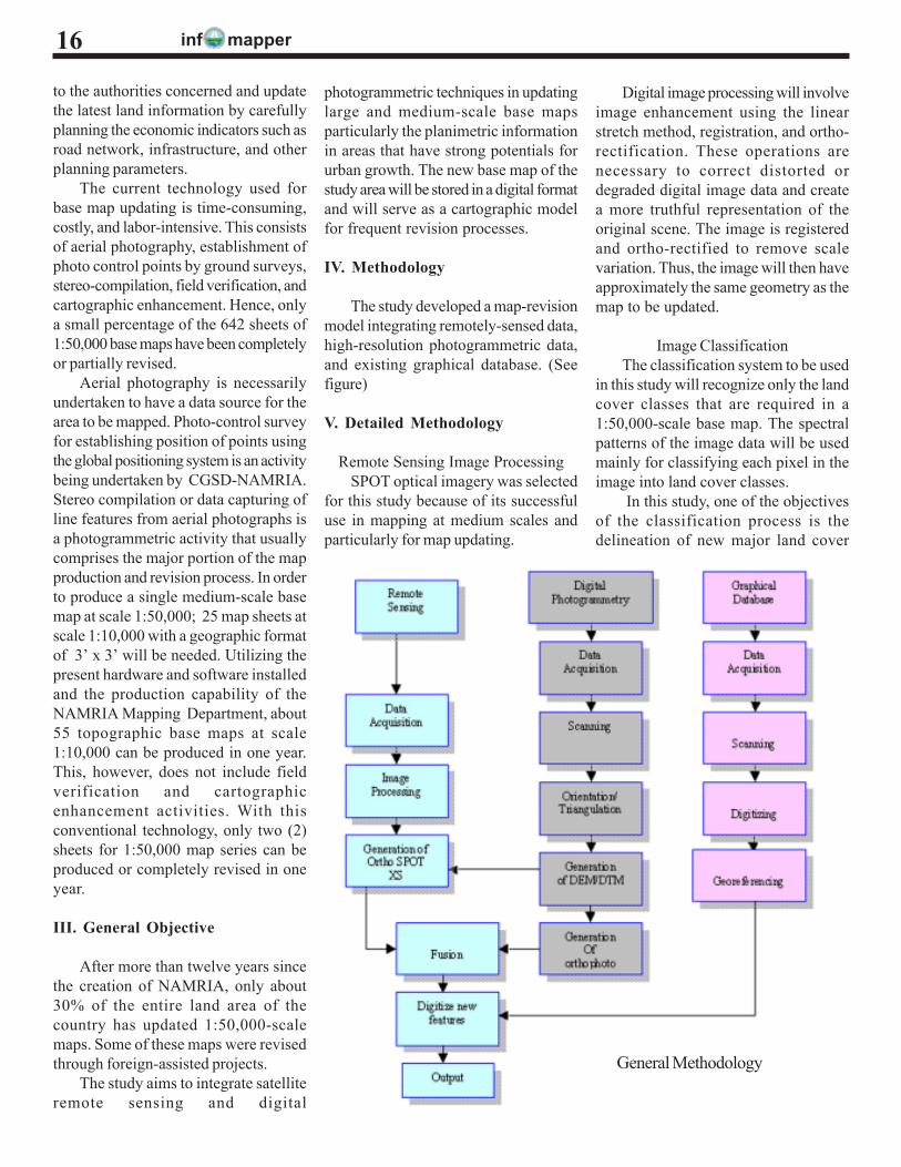
The study developed a map-revisionmodel integrating remotely-sensed data,high-resolution photogrammetric data,and existing graphical database. (Seefigure)
V. Detailed Methodology
Remote Sensing Image ProcessingSPOT optical imagery was selected
for this study because of its successfuluse in mapping at medium scales andparticularly for map updating.
Digital image processing will involveimage enhancement using the linearstretch method, registration, and ortho-rectification. These operations arenecessary to correct distorted ordegraded digital image data and createa more truthful representation of theoriginal scene. The image is registeredand ortho-rectified to remove scalevariation. Thus, the image will then haveapproximately the same geometry as themap to be updated.
Image ClassificationThe classification system to be used
in this study will recognize only the landcover classes that are required in a1:50,000-scale base map. The spectralpatterns of the image data will be usedmainly for classifying each pixel in theimage into land cover classes.
In this study, one of the objectivesof the classification process is thedelineation of new major land cover
General Methodology

inf mapper 17
categories that will serve as inputs toupdate land cover information of thebase map being revised. The resultingland cover classes to be derived fromthe SPOT multispectral (XS) image willbe vectorized and used as polygonboundaries in the data integration toproduce the revised digital base map.
Change DetectionThe change detection technique will
provide information about seasonal orother changes in the land cover. Themethod aims to detect new majorinformation particularly planimetricdetails.
The information is extracted bycomparing and merging two or moreimages of the study area that wereacquired at different times. The digitalnumbers (DN) of one image aresubtracted from those of an imageacquired earlier or later (1982 scannedimage for this study). The resultingvalues for each pixel will be positive,negative, or zero; the latter indicates nochange. The next step is to plot thesevalues as an image in which a neutralgray tone represents zero. Black andwhite tones represent the maximumnegative and positive differencesrespectively. Contrast stretching isemployed to emphasize the differences(Sabins, 1986).
Digital PhotogrammetryThe digital photogrammetric phase
will begin with image scanning, toconvert the photographic images of thestudy area into a digital image file. Stereomodels or pairs of aerial photographs aredigitally scanned using a high resolutionimage scanner which is precisely guidedby a CCD-camera (a camera with aCharge-Coupled Device installed in thefilm or image plane) which traversesover the entire 23 cm x 23 cm imageformat.
The selection of an appropriatesampling interval is important in this partof the research since the correspondingpixel size will have great influence on
the quality of the digital orthophoto thatwill be merged with the SPOT image.Normally, the smaller the pixel size, thebetter the quality of the orthophoto, butnoise increases with very small pixels.Any errors introduced at the scanningstage will remain throughout the digitalphotogrammetric process. It is therefore,essential that the scanner exhibit thehighest possible geometric andradiometric accuracy.
Orientation of the Digital ImagesThe photogrammetric point
measurements determine the positions ofpoint objects in three-dimensional spacefrom digital images of aerialphotographs. Three-dimensionalcoordinates will define these positions.Digital photogrammetric pointmeasurement should yield accurateresults provided certain limitingconditions are observed and can competefavorably with other surveymeasurement techniques. Furthermore,there are some measurement taskswhich can only be performed byphotogrammetry.
The orientation of the images willinclude measurement of fiducial marksof the scanned photographic imagebased on the calibration report of theparticular camera used duringphotography and points (tie points) thatare common to each stereo pair ofphotographs of the study area.
Aerial Triangulation Measurement andAdjustment
In digital aero-triangulation, thetechnique is to automatically measurethe digital images. The software willautomatically determine the x- and y-photo coordinates of points using theimage grey values. Using morecomplicated algorithm based on thegeometry of the scanned photographs,the gray values of these photocoordinates are related to the groundpositions of points. The recreation of thestereo model and their connections aredone digitally.
Model block preparation is done ina form different than that used inconventional aero-triangulation. Ofparticular interest in this research, arethe generation of the topology in higherpyramid levels and measurement in theoriginal images. These two componentsreplace the measurement phase inconventional aero-triangulation. Thecomputation of the bundle blockadjustment, the quality control and thepresentation of results are the next andfinal steps in Automated Aero-Triangulation.
DTM/ DEM GenerationThe first step of digital terrain model
(DTM) generation will be the matchingof homologous interest points out of thefeature pyramid which means thedetermination of an extremely highamount of irregularly distributed masspoints in the image of the study area.Then the grid points of the DTM (whichcan reach up to several ten thousandsof points per stereo model) are derivedfrom these mass points. Because of thehigh redundancy of the process, it ispossible to achieve a high DTM accuracyand to recognize outliers on the surface(single houses and trees) which will beeliminated. During the whole processstatistical parameters are stored for asubsequent quality analysis. The finaloutput will be a grid-DTM of highresolution where the pre-definedexclusion areas and the borderlines areintegrated three-dimensionally.
After the DTM generation, a qualitycheck will be performed. The checkingis based on the analysis of the statisticalparameters and registers possible weakareas. A more detailed DTM check willbe possible by comparison of digitalorthophotos of the two images.
Orthophoto Production and MosaickingOne of the essential features in this
research will be the production of digitalorthophotos from the 1982 aerialphotography of the study area. The resultwill be merged with the multispectral
inf mapper18
mode of SPOT in 1997 using imagefusion techniques and analyzed usingchange detection techniques.
The production of the digitalorthophoto begins with the definition ofthe required image matrix in the XY-plane of the ground coordinate system,followed by the transformation of thecenters of these elements into thecamera coordinate system. For thistransformation, the Z-coordinates of thepoints in the XY-grid are also required.These will result from a very close meshof grid points measured from the digitalterrain models using an analytical stereo-plotter to provide the Z-coordinates of aclose mesh of XY-points.
When all of the digital orthophotoscomprising the study area have beenproduced, individual overlapping pairs willbe combined and enhancements ofcontrast and brightness will be introducedto form the mosaic.
Digital Graphics DatabasingIn order to facilitate access during
updating, a digital graphics database ofthe targeted base map is required.
A 1990 topographic base map atscale of 1:50,000 of the study area willbe scanned at a resolution where thefinest detail particularly planimetricinformation can be easily identified duringon-screen digitizing procedure. Thedigitized planimetric details will have anassigned layer and each layer orcoverage will be geo-referenced at a mapprojection common with that of theoptical image and digital orthophoto.
The editing of all the digitized vectordata will also be undertaken to maintainthe accuracy and integrity of the digitaldata in accordance with standards andspecifications for a 1:50,000 scale basemap.
Data Integration and UpdatingThe new and old information
that are detected and extracted from thefirst interrelated phases of this study canbe integrated to have a model of thestudy area and serve as a prototype formap revision processes. All image data
can be used as a backdrop to come upwith a new image map. Policies and newsystems for revision can be formulatedbased on this model.
VI. Results
Remote Sensing Phase
Image AcquisitionThe subset image of the SPOT XS
data has 1,000 numbers of samples and822 numbers of lines with path number304 and row number 321 respectively.The scene was acquired in May 2, 1997.
Raster-to-Vector ConversionOne land cover class was vectorized
from the final classified image. Inaddition, vectorized cropland was subjectto final editing in the data integration andupdating phase of this study. The otherland cover classes/categories were notvectorized since the expected output forupdating was an image map whichalready depicts planimetric features,e.g., built-up areas including buildings andresidential structures that were detectedin the image fusion task.
Image Fusion and Change DetectionThe image fusion process merged
the 1997 ortho-rectified SPOT XS colorimage with a grayscale 1982 orthophotomosaic. The fusion process included anRGB-to-IHS transform which replacedthe lightness band with the input high-resolution orthophoto and automaticallyresampled the hue and saturation bandsto the high- resolution pixel size usingcubic convolution. The composite RGBimage generated the 5-meter pixel sizeof the input 1982 digital orthophotomosaic.
The first image fusion improved thespatial resolution of the multispectralSPOT image and enhanced planimetricfeatures for map updating within the testarea.
A second fusion mathematicallycombined the 5-meter composite imagegenerated from the initial fusion with the4-meter 1997 orthophoto mosaic
resulting in a more sharpened image.Each band of the composite image wasmultiplied by a ratio of the orthophotomosaic data divided by the sum of thecolor bands. As with the initial imagefusion technique, the composite RGBimage generated from the secondintegration was automatically resampledto a pixel size of 4 meters using cubicconvolution.
The second image fusion did not onlyimprove the spatial resolution of thecomposite RGB image but also gaveadequate change detection results. Man-made changes such as new buildings andresidential structures appearedsignificantly brighter than thecorresponding features in the originalimages of 1982 and 1997.
Since the immediate interest of thisstudy is to extract planimetric featuressuch as new roads and buildingstructures based on the fused images,feature discrimination was used as anevaluation criterion for updating.
Data Integration and Updating
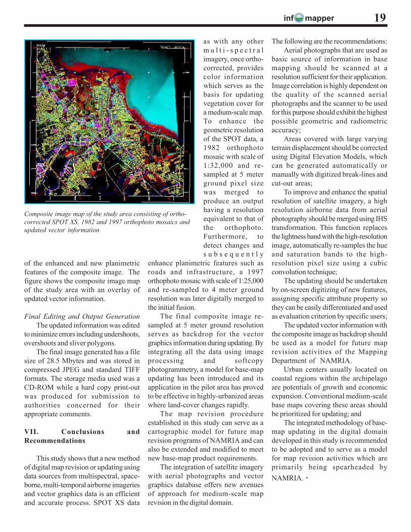
Composite image mappingThe composite image map generated
was a compilation of data from twodifferent sensors acquired in differentseasons in 1982 and 1997 with anoverlay of updated vector linearinformation. The composite imageryconsists of the ortho-corrected multi-spectral SPOT data and two sets oforthophoto mosaics with 5 and 4 meterground resolutions respectively. Theortho-rectified multispectral SPOT dataprovides the color information, the 1982orthophoto mosaic enhanced theplanimetric details, and the 1997orthophoto mosaic contributed newinfrastructure enhancement for the finalimage map.
The updated planimetric informationcan be easily differentiated since thesehave different attribute properties, e.g.,color and line style, different from theexisting features in the geo-referenceddigital graphics database. The updatingemployed on-screen digitizing techniques
inf mapper
of the enhanced and new planimetricfeatures of the composite image. Thefigure shows the composite image mapof the study area with an overlay ofupdated vector information.
Final Editing and Output GenerationThe updated information was edited
to minimize errors including undershoots,overshoots and sliver polygons.
The final image generated has a filesize of 28.5 Mbytes and was stored incompressed JPEG and standard TIFFformats. The storage media used was aCD-ROM while a hard copy print-outwas produced for submission toauthorities concerned for theirappropriate comments.
VII. Conclusions andRecommendations
This study shows that a new methodof digital map revision or updating usingdata sources from multispectral, space-borne, multi-temporal airborne imageriesand vector graphics data is an efficientand accurate process. SPOT XS data
as with any otherm u l t i - s p e c t r a limagery, once ortho-corrected, providescolor informationwhich serves as thebasis for updatingvegetation cover fora medium-scale map.To enhance thegeometric resolutionof the SPOT data, a1982 orthophotomosaic with scale of1:32,000 and re-sampled at 5 meterground pixel sizewas merged toproduce an outputhaving a resolutionequivalent to that ofthe orthophoto.Furthermore, todetect changes ands u b s e q u e n t l y
enhance planimetric features such asroads and infrastructure, a 1997orthophoto mosaic with scale of 1:25,000and re-sampled to 4 meter groundresolution was later digitally merged tothe initial fusion.
The final composite image re-sampled at 5 meter ground resolutionserves as backdrop for the vectorgraphics information during updating. Byintegrating all the data using imageprocessing and softcopyphotogrammetry, a model for base-mapupdating has been introduced and itsapplication in the pilot area has provedto be effective in highly-urbanized areaswhere land-cover changes rapidly.
The map revision procedureestablished in this study can serve as acartographic model for future maprevision programs of NAMRIA and canalso be extended and modified to meetnew base-map product requirements.
The integration of satellite imagerywith aerial photographs and vectorgraphics database offers new avenuesof approach for medium-scale maprevision in the digital domain.
The following are the recommendations:Aerial photographs that are used as
basic source of information in basemapping should be scanned at aresolution sufficient for their application.Image correlation is highly dependent onthe quality of the scanned aerialphotographs and the scanner to be usedfor this purpose should exhibit the highestpossible geometric and radiometricaccuracy;
Areas covered with large varyingterrain displacement should be correctedusing Digital Elevation Models, whichcan be generated automatically ormanually with digitized break-lines andcut-out areas;
To improve and enhance the spatialresolution of satellite imagery, a highresolution airborne data from aerialphotography should be merged using IHStransformation. This function replacesthe lightness band with the high-resolutionimage, automatically re-samples the hueand saturation bands to the high-resolution pixel size using a cubicconvolution technique;
The updating should be undertakenby on-screen digitizing of new features,assigning specific attribute property sothey can be easily differentiated and usedas evaluation criterion by specific users;
The updated vector information withthe composite image as backdrop shouldbe used as a model for future maprevision activities of the MappingDepartment of NAMRIA.
Urban centers usually located oncoastal regions within the archipelagoare potentials of growth and economicexpansion. Conventional medium-scalebase maps covering these areas shouldbe prioritized for updating; and
The integrated methodology of base-map updating in the digital domaindeveloped in this study is recommendedto be adopted and to serve as a modelfor map revision activities which areprimarily being spearheaded byNAMRIA. ·
19
Composite image map of the study area consisting of ortho-corrected SPOT XS, 1982 and 1997 orthophoto mosaics andupdated vector information
inf mapper20
The
Info
map
per
A P
ublic
atio
n on
Sur
veys
, Map
ping
, and
Res
ourc
e In
form
atio
n Te
chno
logy
Nat
iona
l Map
ping
and
Res
ourc
e In
form
atio
n A
utho
rity,
For
t And
res
Bon
ifaci
oM
akat
i City
PRIN
TE
D M
AT
TE
R
NAMRIA and NCIP embarked ona joint project, entitled “Survey and Map-ping of the Ancestral Domain of the In-digenous Cultural Communities (ICCs)/IPs,” through a memorandum of agree-ment which was signed on 15 February2002. This project aims to survey anddelineate seven priority Certificate ofAncestral Domain Claim (CADC) ar-eas covering CADC 046 (Kiangan,Ifugao) as the pilot area, CADC 021(Kasibu, Nueva Vizcaya), CADC 055(Iriga, Camarines Sur), CADC 166(Dumarao, Capiz), CADC 172(Manbajao, Camiguin), CADC 012(Arakan, Cotabato), and CADC 176 (LaPaz, Agusan del Sur). The ancestraldomain, which is covered by a CADC,refers to all areas generally belonging toICCs or IPs. This comprises lands, in-land waters, coastal areas, and naturalresources therein, which are held underclaim of ownership, occupied or pos-sessed by ICCs/IPs, by themselves orthrough their ancestors since time im-memorial.
The scope of work for the projectincludes IEC through the conduct of con-sultation meetings of the seven target pri-ority CADC areas. On 18 November2002, a general consultation meeting washeld at Lagawe, Ifugao which was at-tended by 120 tribal leaders, local gov-ernment officials of six adjoining munici-palities of Kiangan, NCIP personnel, andNAMRIA officials. Clustering of the dif-ferent municipalities was done to facili-tate easier and faster consultation con-sidering that the municipalities are apartand virtually inaccessible from eachother. Community level consultationmeetings were also conducted on theadjoining municipalities of Kiangan,
Survey and mapping of ancestral domainsby Olivia R. Molina1
namely: Lamut, Lagawe, Hingyon,Asipulo, Hungduan, and Tinoc. Similaractivities are being prepared for theProvinces of Nueva Vizcaya, CamarinesSur, Capiz, Camiguin, Cotabato, andAgusan del Sur.
While public awareness campaign isnecessary, it is also equally important todevelop the knowledge and skills of thetechnical personnel and staff in chargeof the project implementation. For thispurpose, the NAMRIA GTC was taskedto conduct training on perimeter surveyfor the survey teams of NAMRIA andNCIP. The GTC is also in charge of theconduct of various training needs of theproject personnel. These include, amongothers: basic mapping, introduction toGIS, basic ArcView, and GIS prototypesuser’s training.
Further, 40 LANDSAT scenes cov-ering the entire country and mapping sup-plies were procured for use in the project.Computer software and hardware, sur-veying equipment and mapping facilitiesearmarked for the project had also beenupgraded. In addition, 12 personnel spe-cialists were hired to digitize and encodedata from the field.
To date, a total of 46 CADCs havebeen gathered of the necessary data.These are located in Pangasinan (2),Nueva Vizcaya (3), Quirino (4),Camarines Sur (8), Ifugao (2), Kalinga(2), Misamis Oriental (2), Camiguin (1),Cotabato (1), South Cotabato (4),Agusan del Sur (8), Capiz (2), Abra (5),and Ilocos Sur (2). ·
1Chief, Land Classification Division (RSRDAD)