HandbooK - UN-Habitat
56
INTERNATIONAL GUIDELINES ON URBAN AND TERRITORIAL P LANNING HANDBOOK
Transcript of HandbooK - UN-Habitat

InternatIonalGuIdelInes onurban and terrItorIal PlannInG
HandbooK


InternatIonalGuIdelInes onurban and terrItorIal PlannInG
HandbooK

International Guidelines on urban and territorial Planning (IG-utP) Handbook
First published in Nairobi in 2018 by UN-HabitatCopyright © United Nations Human Settlements Programme, 2018
All rights reservedUnited Nations Human Settlements Programme (UN-Habitat)P. O. Box 30030, 00100 Nairobi GPO KENYATel: 254-020-7623120 (Central Office)www.unhabitat.org
HS Number: HS/052/18E
Acknowledgements
Coordinators: Shipra Narang Suri and Remy SietchipingContributors: Ulrich Graute, Frank D’hondt, Laura Petrella, Manka Bajaj and Andrea OyuelaDesign and layout: Herbert KIMANI
Disclaimer The designations employed and the presentation of the material in this publication do not imply the expression of any opinion whatsoever on the part of the Secretariat of the United Nations concerning the legal status of any country, territory, city or area or of its authorities, or concerning the delimitation of its frontiers of boundaries.Views expressed in this publication do not necessarily reflect those of the United Nations Human Settlements Programme, the United Nations, or its Member States.
Excerpts may be reproduced without authorization, on condition that the source is indicated.

IG-UTP HandBook
In 2015, the UN-Habitat Governing Council approved the International Guidelines on Urban and Territorial Planning (IG-UTP), a set of universal planning principles for the improvement of planning and management at all levels, from neighbourhood to city level, and beyond, to regional, national and transboundary levels. Urban and territorial planning has been thought of as an exclusive competence of national and local authorities. However, as our cities continue to grow and their stakeholders become increasingly diverse, planning needs to change. The Guidelines advocate for planning as an integrated and participatory decision-making process to plan and manage our cities and territories in a holistic manner.
The IG-UTP are the single most downloaded publication of UN-Habitat. They are also explicitly referenced in the New Urban Agenda. These are testimonies to the gap the Guidelines fill, and the quality of guidance they provide. This Handbook has been designed as an accompanying tool that will assist national governments, local authorities, planning professionals, and civil society organizations in collectively applying the Guidelines to improve planning frameworks and practice at all levels of governance and across the spatial planning continuum. While the Guidelines advocate shared responsibilities and collaborative planning, the Handbook provides a breakdown of the process and elements needed to attain the outcomes, which the Guidelines ultimately aim to achieve.
I encourage countries, cities and their citizens to make use of the Guidelines and this Handbook, to harness the power of planned urbanisation towards sustainable social and economic development, and the realisation of the New Urban Agenda and the Sustainable Development Goals.
Foreword
I encourage countries, cities and their citizens to make use of the Guidelines and this Handbook, to harness the power of planned urbanisation towards sustainable social and economic development, and the realisation of the New Urban Agenda and the Sustainable Development Goals.
Maimuna Moh’d Sharif
Executive Director, UN-Habitat

IG-UTP HandBook
Table of Contents
SUMMARY ..............................................................................................................................................1
1. INTRODUCTION ................................................................................................................................2
Urban and territorial planning as one pathway for sustainable development .................3
2. ABOUT THIS HANDBOOK ..........................................................................................7
3. THE PROCESS: Planning as an integrative and participatory decision-making process ......11
3.1 The urban and territorial planning process ............................................................12
3.1.1 Why do we need integrative and participatory planning? ..........................123.1.2 Who plans? The four stakeholder groups ..................................................133.1.3 The enabling environment and other impact factors of urban and territorial
planning ...................................................................................................14
3.2 Urban and Territorial Planning Components ..........................................................15
3.2.1 Rules and regulations governing urban and territorial planning .................153.2.2 Phases of planning ...................................................................................15
3.3 Conclusion ............................................................................................................19
Checklist for the process of integrated and participative planning ...............................20
4. THE PRODUCTS: Policies, plans, and designs ...............................................................21
4.1 What kind of Plans? ..............................................................................................22
4.2 Policies, plans and designs at five planning scales .................................................22
4.2.1 Supranational and transboundary planning ...............................................234.2.2 National planning .....................................................................................234.2.3 City-regional and Metropolitan planning ...................................................244.2.4 City-wide and municipal planning .............................................................254.2.5 Neighbourhood planning ..........................................................................254.2.6 Area & theme specific planning ................................................................26

IG-UTP HandBook
4.3 Review of planning systems ..................................................................................26
4.4 Conclusion ............................................................................................................27
Checklist on policies, plans and design of integrated and participative planning ..........28
5. THE OUTCOMES: Fostering sustainable urban and territorial development .....................31
5.1 Sustainable development as outcome of urban and territorial planning .................32
5.2 What does planning need to achieve? The main aim and its five qualifiers ............34
5.2.1 Planning more compact places ..................................................................345.2.2 Planning socially more inclusive places .....................................................345.2.3 Planning better connected places .............................................................355.2.4 Planning places that are more resilient to climate change and natural
disasters ...................................................................................................365.2.5 Integrated planning ..................................................................................375.2.6 Outcome indicators ..................................................................................38
5.3 Conclusion ............................................................................................................38
Checklist on outcomes ................................................................................................38
6. THE ROLE OF UN-HABITAT & PARTNERS .....................................................................39
LITERATURE AND RESOURCES .......................................................................................42

IG-UTP HandBook
List of Acronyms
AFINUA Action Framework for Implementation New Urban AgendaAgenda 2030 Transforming our world: the 2030 Agenda for Sustainable DevelopmentCCCI UN-Habitat’s Climate Change InitiativeCSO Civil society organizationESDP European Spatial Development PerspectiveESPON European Spatial Planning Observatory Network EU European UnionGHG Greenhouse gasGIS Geographic information systemIG-UTP International Guidelines on Urban and Territorial PlanningNGO Non-governmental organizationNTP National territorial plansNUA New Urban AgendaNUP National urban policiesSEZ Special economic zoneSDG Sustainable Development Goals (part of the 2030 Agenda)SWOT Analysis of strengths, weaknesses, opportunities and threats/challengesUN United NationsUN-Habitat United Nations Human Settlements ProgrammeUTP Urban and territorial planning
1IG-UTP HandBook
Summary
This handbook for the International Guidelines on Urban and Territorial Planning (IG-UTP) is part of a series of tools designed to improve planning practice. The guidelines themselves are not a blueprint for an imaginary ideal planning process. Instead, the principles and recommendations of the guidelines give advice on what is most important to successfully coordinate an integrated and participatory planning process for sustainable development. This handbook provides an overview of the scope of topics covered by the IG-UTP and puts special emphasis on planning processes, products and outcomes. In addition, it refers to additional tools, literature and resources for planners, civil society and policy makers at national and local levels.
Chapters 1 and 2 of this handbook provide an introduction and guidance on how it can be used. Chapter 3 elaborates on the conditions of success in the various stages of planning (diagnostic, formulation, implementation, monitoring & evaluation). It demonstrates that integrated and participative planning is not only necessary to promote local democracy, participation and inclusion, transparency and accountability, but that it is also a pre-condition to informed decision-making and effective implementation. It is only through such an integrative approach and the inclusion of all stakeholders that the risk of failure can be minimized. Furthermore, planning phases are iterative and not necessarily linear. Monitoring and evaluation may identify deficits, which requires another look at the process to improve diagnosis and plan formulation or to improve capacities for the implementation.
Chapter 4 provides guidance on designing effective planning products (policies, plans and designs) that support sustainable planning outcomes. In the phases
of production and realization of policies, plans and designs, a number of visions, strategies and actions take shape and transform cities and territories. Rapid urbanization and other dynamics generate new situations, challenges and opportunities. Therefore, the review of planning processes and the systems themselves is a constant challenge to find even better ways to achieve integrated and participative planning. With respect to the content of plans, there is a general distinction between planning products at the higher levels, which are more holistic and comprehensive, and those at the city or neighbourhood level, which are more specific.
Moving further, Chapter 5 discusses challenges related to planning for sustainability. Planning by itself cannot ensure that sustainability will be achieved. However, applying the principles of the guidelines can support the development of diverse planning approaches adapted to different context and scales aimed at sustainable development. To monitor if planning is on track for more sustainable urban and territorial development, UN-Habitat identifies five qualifiers which are described in the chapter: planning aims at: (1) compact, (2) inclusive, (3) connected, (4) resilient and (5) integrated places. The chapter closes with a discussion on outcome indicators.
Chapter 6 provides guidance on the role of UN-Habitat and partners in supporting implementation of the guidelines. Chapter 7 refers users to additional literature and resources that could be beneficial in reviewing and improving urban and territorial planning in their respective contexts.

2 IG-UTP HandBook
I. IntroductIon
3IG-UTP HandBook
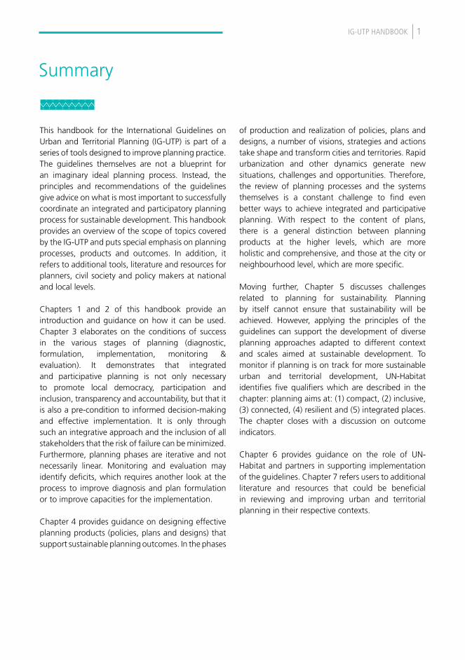
The role of urban and territorial planning in the achievement of a sustainable future cannot be over-emphasized. Urbanization is progressing rapidly. By the year 2050, 70 per cent of the global population will be living in urban areas. The urban form determines the distribution of a population’s density and activities, and is therefore a key determinant of the per capita cost and consumption of limited resources, such as land, water, energy and infrastructure.
In developing countries, where much of this urban growth will take place, the projections for 2030 show that, while the urban population will double, the area covered by cities could triple.
Most countries practise some form of territorial planning to influence urban forms and functions. However, it is unclear whether these instruments and processes are effective, what type of outcomes they are delivering and for whom? Sometimes, plans are not implemented or building standards and land tenure options are not feasible for all population
groups; hence, such regulations can, ironically, become obstacles in the path of economic, social and environmental goals. In many cases, planning administrations were set up in colonial times or in different socio-economic and political circumstances and may not fit the present scenario of available resources and needed capacities.
In developing and transitioning countries, particularly urban and territorial planning predominantly regulates formal activities and is unable to meet the emerging needs of new residents and workers in the city. Moreover, as planetary limits are becoming more evident, there is a genuine drive in government and the private sector to try to do more with fewer resources. Still, even though these factors paint a grim picture, the good news is that there is now a strong global consensus that sustainable development is a shared goal. With this idea, there is also a formal recognition of the role for integrated and participatory urban and territorial planning with some guidance on how to “re-invent” planning.
Figure 1: Urban and rural population of the world, 1950 – 2050 (United Nations 2015)

4 IG-UTP HandBook
urban and terrItorIal PlannInG as one PatHway for sustaInable develoPment
Generally, for every 10 per cent increase in urban sprawl, there is an equal increase in per capita hazardous pollution and a 5.7 per cent increase in per capita carbon dioxide emissions (United Nations Economic and Social Council, 2016). Thus, in order to curtail the environmental footprint of urbanization, we will need (among other instruments) effective territorial strategies that discourage sprawl and encourage urban forms and patterns conducive to sustainable development.
Although many of the effects of inappropriate and inadequate planning of settlements (e.g. proliferation of slums, segregation, congestion, food insecurity, environmental pollution or health hazards) are experienced locally, much of the problem solving requires action at larger geographical scales, including the global level. Recognizing the interconnectedness and complexity of several of these issues, the 2030 Agenda for Sustainable Development identifies 17 thematic areas, or Sustainable Development Goals (SDGs), which countries have committed to attaining within the next 15 years. When applied to a specific geographical area or territory, most of these goals are relevant and hence overlap. Thus, cities are affected by the entire 2030 Agenda as the bulk of SDG action (e.g. Goals 3, 6, 7, 11, 12, 13) tends to be located in urban areas, which in the end, host the majority of the global population. In addition, one particular SDG (Goal 11: Make cities and human settlements inclusive, safe, resilient and sustainable) specifically aims to deliver sustainable outcomes at the level of a human settlement, with specific targets (11.a, 11.3 and 11.7) related to territorial planning.
The New Urban Agenda is essentially an action blueprint for countries to achieve sustainable development using an urban “lens”. The document identifies “planning and managing urban spatial development” as one of the three pillars of effective implementation of the agenda, and contains more than 50 references to “urban and territorial planning” throughout the text. “Urban and territorial planning and design” is also identified in UN-Habitat’s Action Framework for Implementation of the New Urban Agenda (AFINUA) as one of the five main ingredients to implement the New Urban Agenda in support of the SDGs, putting emphasis on SDG 11 once again. The logic behind this specific terminology is that urban and territorial planning and design should not be limited to the planning of an urban settlement alone, as if it were an isolated entity. Instead, urban settlements should be seen as part of a larger territorial fabric.
Planning, then, is a tool to support effective urban-rural linkages as well as complementarities in functions of different settlements. An urban and territorial strategy may, for instance, require cooperation between different municipalities in order to cover functional urban areas spilling out of their jurisdictional boundaries. This would mean that infrastructure investments are informed by an urban and territorial strategy rather than a single-sector strategy, which in turn, would require coordination and integration between urban and territorial plans and sector strategies. The New Urban Agenda points us to the recommendations of the International Guidelines on Urban and Territorial Planning for further guidance on this subject (NUA, paragraph 93).
5IG-UTP HandBook
InternatIonal GuIdelInes to suPPort urban and terrItorIal PlannInG Urban and territorial planning is complex and addresses multiple challenges.
Urban and territorial planning can be defined as a decision-making process aimed at realizing economic, social, cultural and environmental goals through the development of spatial visions, strategies and plans and the application of a set of policy principles, tools, institutional and participatory mechanisms and regulatory procedures”
The International Guidelines on Urban and Territorial Planning, p2
Different approaches to urban and territorial planning are being promoted and practised worldwide, including city-wide strategic planning, master planning, community planning, land-use planning, etc. With the 2030 Agenda and New Urban Agenda, urban and territorial planning has emerged as a central instrument in support of sustainable development. This is also due to the fact that UN-Habitat’s International Guidelines on Urban and Territorial Planning (IG-UTP) were developed and adopted by UN-Habitat’s Governing Council in 2015, just as the discussions on the Agenda 2030 were gaining momentum, and well in time for the development and negotiations of the New Urban Agenda.
The preparation of the Guidelines followed a two-year consultative process which concluded in April 2015 with Resolution 25/6 of the Governing Council of UN-Habitat. In this process, representatives of national and local governments, civil society and associations of planning professionals, convened in the form of an Expert Group that met on three occasions, and agreed on a set of universally applicable principles to guide urban and territorial planning in varying contexts around the world.
The IG-UTP emphasize that whatever the approach chosen, successful implementation of plans always requires strong political will, appropriate partnerships involving all relevant stakeholders and three key enabling components:
(i) Enforceable and transparent legal frameworks (ii) Sound and flexible urban planning and
design, and (iii) A financial plan for affordability and cost-
effectiveness
The Guidelines consist of 12 key principles and 114 action-oriented recommendations. These recommendations are based on evidence gathered from 26 city-regions, and the lessons learnt have been documented in an accompanying Compendium of Inspiring Practices.
Thus, the guidelines provide a global framework for improving “policies, plans, designs and implementation processes” for more compact, socially inclusive, better integrated and connected cities and territories that foster sustainable urban development and are resilient to climate change. The recommendations are customized for each of the four target user groups: (i) national governments, (ii) local authorities, (iii) civil society organizations and their associations, and (iv) planning professionals and their associations. Taking into account the principle of subsidiarity, the guidelines are applicable through the multi-scale continuum of urban and territorial planning, i.e. from the supranational to the neighbourhood level.
In a globalizing and rapidly urbanizing world, the guidelines can be used as a compass to help improve planning processes, products and outcomes. As a document meant for universal application, the guidelines provide a comprehensive set of issues for consideration in the review, development and implementation of urban policies and urban and territorial planning frameworks. They complement two other sets of international guidelines, one on Decentralization and the Strengthening of Local Authorities (2007) and Access to Basic Services for All (2009). Yet, while the IG-UTP serve as a compass to guide decision-makers, they are not a manual ready for application. A practical companion is required to operationalize their principles and recommendations. This handbook was envisaged to unpack the guidelines and serve as an organizing frame for various tools which support their adaptation and implementation in different national and sub-national contexts.

6 IG-UTP HandBook
PROCESSES11
IG-UTP
FINANCE
NationalGovernments Local
Authorities
CivilSociety
START!
PlanningProfessionals
NEWURBANAGENDA
RULES®ULATIONS
PLANNING
The IG-UTP as a channel for achieving the New Urban Agenda and the Sustainable Development Goals

7IG-UTP HandBook
2. about tHIs HandbooK

8 IG-UTP HandBook
objectIve of tHe HandbooK
The target audience of the handbook, as of the guidelines, includes stakeholders in national governments, local governments, planning professionals and their associations and civil society organizations. National governments are decision-makers on national policies framing urban and territorial planning (like national urban policies and policies on financing of local governments); local authorities and planning professionals are active in formulating and implementing planning decisions; and civil society is impacted by and has power to comply or not with these decisions. Where national and local authorities do not engage the civil society in participative planning and decision-making as promoted by the guidelines, they risk taking decisions about plans which are not sufficiently informed and may fail more easily.
But how can a single handbook offer practical guidance on how to apply the guidelines if the target audience is composed of different stakeholder groups and, in addition, if the audience is global with knowledge and experience which differs considerably depending on the local context and individual background? It can, because the challenge to assure integrated and participative urban and territorial planning for sustainable development is a challenge all around the world. Planning systems vary from country to country, but stakeholders everywhere have to prove anew that their input generates the policies, plans and designs (as planning products) necessary to move towards sustainable urban and territorial development as the intended outcome of planning.
Some stakeholders turn to the handbook because they struggle with a planning process. Others may have an issue with planning products. The handbook offers national and local authorities, planning professionals and civil society the choice of an entry point (Figure 3) in the planning system where the felt need for improvements is most urgent. They may start using the handbook at their entry point of choice and then work through the chapters following the interrelations between planning phases, planning scales/levels etc.
Planning outcomes are determined by many factors (e.g. thematic issues) and so this handbook limits itself to deal with only two factors: planning process and planning products/instruments. Other determinant factors for good outcomes, such as effective leadership, strong civil society etc., are briefly addressed, but their detailed discussion is beyond the scope of this handbook. Processes and products are the backbone of planning and by putting these two determinants and their intended outcomes at the centre of the handbook, it is possible to unpack the principles and recommendations of the guidelines. The added value of the handbook is that it discusses the principles in the context of planning processes and products, and refers to tools and checklists which can help stakeholders to review and inspire improvements of their own engagement in entire planning processes or at single entry points.
The Theory of Change of this handbook (Figure 4) describes what the handbook provides (inputs), what outputs will be achieved on the side of planning stakeholders and other readers, and what are the intended outcomes in the long run.
THEMES
Public space
5 QUALIFIERS
Compact
Connected
Integrated
Resilient
Inclusive
Land
Health
PRODUCTS
Plans
Policy
Design
PROCESSES
Administration
Regulation
Education
THE PLANNING SYSTEM
Figure 3. Entry points for the improvement of planning systems.

9IG-UTP HandBook
Content and structure of the Handbook
This handbook is part of a series of IG-UTP tools designed to improve planning practice. It provides an overview of the scope of topics covered by the IG-UTP and puts special emphasis on planning processes, products and outcomes. An IG-UTP-based approach requires that planning is examined not only as a technical tool for urban and territorial change, but is also tested for the quality of the decision-making processes (e.g. coordination, participation, spatial continuity). Therefore, the topics covered in this handbook include both planning processes (mechanisms to elaborate, update and implement plans) and planning products (policies, plans and designs) both of which contribute to effective functioning of the planning system and enabling better planning outcomes.
The handbook is structured as follows: following the two introductory chapters, Chapter 3 elaborates conditions of success in the planning process across various stages (diagnostic, formulation,
implementation, monitoring & evaluation). Chapter 4 provides key guidance in designing effective planning products (policies, plans and designs) that support both implementation processes and sustainable planning outcomes. Chapter 5 breaks down what is meant by good planning outcomes and discusses the requirement of outcome indicators. Chapter 6 provides guidance to start implementing the guidelines, be it a government or non-government actor. Moreover, this chapter explains how the United Nations and partners can be invited to assist in different modules, projects and country programmes. Chapter 7 refers the user to literature and resources that could be beneficial in reviewing and improving urban and territorial planning.
The terminology used in urban and territorial planning and related academic discussions is not consistent around the world. For consistency with the guidelines, this handbook follows the terminology used in the guidelines as appropriate.
Figure 4: Theory of Change for this Handbook
Unpacking the Guidelines by discussing principles and recommendations in context of planning processes, products and their intended outcomes
Referring to useful tools
Providing checklists
Referring to useful literature
Planning stakeholders and other readers understand better the importance of integrated and participative planning for sustainable urban development.
They understand requirements to review planning processes.
They understand how other tools and literature can be of help.
Reviewed and improved planning systems
More effective management of planning
Improved planning products
• Policies• Plans• Designs
Improved quality of decision-making.
Improved plan implementation processes
(Improved = more realistic and applicable)
Inputs Outputs Outcomes

10 IG-UTP HandBook
Table 1: Summary of the 12 principles for urban and territorial development as described in the IG-UTP

11IG-UTP HandBook
3. tHe Process: Planning as an integrative and participatory decision-making process

12 IG-UTP HandBook
This chapter is on planning as a process; its components, phases and how the process is governed. It discusses why integrated and participative planning is necessary, describes planning actors and stakeholders, and the advantages of an enabling environment for planning. This is followed by a description of the four planning phases: diagnosis, plan formulation, implementation and evaluation, along with what guidance the IG-UTP provide for these planning processes.
3.1 tHe urban and terrItorIal PlannInG Process
The planning process is about actions or activities undertaken for the elaboration and delivery of policies, plans and designs at all levels and across the urban-rural continuum; such processes are often complex and stretch over several years. They include the production of policies, plans and designs, the so-called planning documents (also referred to in Chapter 4 as ‘the products’), and linked to this is the participative decision-making process. Planning documents inform the decision-making process on what is possible, by whom and at what cost. In turn, the participative decision-making process informs the production of plans in regards to preferences of stakeholders. Therefore, the production of planning documents and the participative decision-making throughout the process constitute the overall planning process.
Under this context, the Guidelines and this Handbook first address decision-making processes in urban policy and governance as described in the first two principles of the IG-UTP:
3.1.1 Why do we need integrative and participatory planning?
Integrative and participatory planning
Urban and territorial planning is an integrated and participatory decision-making process to plan and manage our cities and territories in the most sustainable way – harnessing past and present urban and territorial assets while preserving similar or even better chances for future generations. Therefore, urban and territorial planning requires strong political will to implement policies, plans and designs alongside a transparent legal framework, flexible urban planning and design, and effective financial plans. Changes in population growth, demographic shifts and economic forces in regions reconfigure the dynamics of urban areas and territories, which consequently require adjustments of the planning process.
Considering urban and territorial planning addresses so many issues and challenges and must juggle with several individual and institutional interests, integrative and participative decision-making is imperative. Moreover, these approaches along with participative, transparent and accountable processes strengthen the sense of community and contribute to trust-building within a local community and the society as a whole. Hence, planning processes can also support social and political cohesion of the people in addition to the foreseen planning outcome (see Chapter 5) of territorial cohesion.
Principle 1 Urban and Territorial Planning is an integrative and participatory decision-making process that addresses competing interests and is linked to a shared vision, an overall development strategy and national, regional and local urban policies.
Principle 2 Urban and Territorial Planning promotes local democracy, participation and inclusion, transparency and accountability.

13IG-UTP HandBook
Planning laws, building codes and other rules and regulations include formal procedures that establish when stakeholders are to be heard, how and who can be heard. Still, there informal forms of participation such as public hearings, surveys and planning ‘labs’ also make it possible for stakeholders to provide their input to the planning and decision-making process. Therefore, in order to achieve integrated and efficient planning, it is important to include participative elements throughout all phases of the planning cycle, all the way from diagnosis, to plan formulation and implementation, and to evaluation.
A shared vision versus competing interests
Consensus-building in decision-making processes is not easy. A planning process can easily become trapped between competing interests. This challenge can be overcome by planning actors and stakeholders sharing a vision and strategy on how to use the common territory, because a shared vision sets the common ground and foundation for further dialogue. Considering the five levels (or scales) of planning - from the neighbourhood to the transboundary level - it is recommended that those involved develop a national, or even international, vision for territorial development that is broken down into regional, local and neighbourhood visions and strategies. To do this at all levels in collaboration with many stakeholders working across different levels may appear to be complicated, but in practice it reduces complexity due to the division of tasks and clarification of responsibilities between planning levels (see Section 4.2 for further detail).
While over time, countries and people have developed international treaties on economic, social and environmental issues, it was not until recently that governments realized the need to discuss and agree on principles for planning and managing cities and territories, including principles that affect situations beyond national and regional boundaries. The foundation stone for this change was the adoption of the International Guidelines on Urban and Territorial Planning by UN-Habitat’s Governing Council in April 2015.
One year later, Article 9 of the NUA reaffirmed the global commitment to sustainable urban development as
:...a critical step for realizing sustainable development in an integrated and coordinated manner at the global, regional, national, subnational and local levels, with the participation of all relevant actors.
Hence, the implementation of the NUA contributes to the implementation and localization of the 2030 Agenda for Sustainable Development in an integrated manner, and to the achievement of the Sustainable Development Goals and their targets, particularly those for SDG 11. Moreover, even though there is no intention to develop any binding urban and territorial planning treaty, the NUA provides the first universal platform to exchange best practices and to enable and enhance review and reform of urban and territorial planning (including through city-to-city cooperation and capacity building) to increase the performance of urban and territorial planning.
3.1.2 Who plans? The four stakeholder groups
The guidelines promote the development and improvement of urban and territorial policies, plans and designs by targeting a continuous dialogue and the establishment of partnerships among four key stakeholder groups:
a) National Governments b) Local Authoritiesc) Planning Professionals and their Associations d) Civil Society Organizations and their
Associations
National governments are responsible for national urban and territorial policies, financial and other policies that influence urban and territorial planning and development. In addition, national governments own territory and their interests are affected by many plans. Local authorities are the key stakeholder governing urban and territorial planning processes. Associations of planning professionals take part in many planning processes and, more importantly, individual planning professionals work, e.g. as a planner or researcher for government authorities, civil society and the private sector (e.g. planning

14 IG-UTP HandBook
firms). Thus, they are part of all stakeholder groups. Nonetheless, due to their professional background, planners are referred to in the guidelines as a stakeholder group of their own. The stakeholder group of civil society organizations (CSO) includes a wide range of actors from small grassroots and community-based initiatives to global non-governmental organizations.
Thus, all the aforementioned stakeholder groups described in the guidelines are always either a planning actor or decision-maker, but in different roles depending on the planning document and process. One example is in the formulation of a city-wide strategic plan, where the local authority is the leading stakeholder but where, later in the implementation phase, this leading role may be attributed to a private developer or a (CSO)1.
3.1.3 The enabling environment and other impact factors of urban and territorial planning
Planning processes are shaped not only by institutions, laws, regulations and procedures, but also by the policy environment and by the ways stakeholders communicate their interests and needs.
The policy environment
The policy environment is the sum of the external impacting factors on urban and territorial planning and policies although they do not belong to urban and territorial laws, rules and policies. These could be an emerging local development challenge, a national or international trend in public opinion, or academic discussions and dialogue among experts. For instance, the Athens Charter (1943) published by Swiss architect Le Corbusier (Charles-Édouard Jeanneret), discussed urban planning through its model of the ‘functional city’, generating a significant impact on planning discourse after the Second World War. In the meantime, changes in societies, urban growth and problems in applying Western modernist approaches to the reality of rapidly growing and poor cities signalled a need for
1 For more information on the planning phases, please refer to Section 3.2.2.
innovative approaches (UN-Habitat, 2009, pp. 47-71). Today, Agenda 2030 and the New Urban Agenda, though not legally binding documents, change the policy environment, have an impact on policy development and require changes in many fields, including urban and territorial planning in United Nations Member States.
Furthermore, a policy environment is also necessary within levels of government and not only at an international level. The support to effective decentralization of powers is one example, as it is necessary to enable local governments to generate revenues from planning (e.g. through land-based financing, density taxation, and so on) and, in turn, making these revenues a precondition for investments in urban and territorial development.
Other factors influencing the planning process
Orientations (interests and purposes) and capabilities (skills and resources) of stakeholders are other factors influencing the planning process. A powerful interest may be the investment interest of a company, or the reaction of citizens in favour or against such an investment. In addition, stakeholders do not act alone, but build constellations with other stakeholders. This may be an advocacy coalition, a spontaneous protest by citizens, or an intervention from an already existing network of NGOs. In alignment with Principle 2 of the IG-UTP on local democracy, participation and inclusion are very important in order to take into account orientations, capabilities and constellations of actors into the planning process. To consider and to be responsive to all their input, informed decision-making is necessary as it increases transparency and accountability of the process.

15IG-UTP HandBook
3.2.1 Rules and regulations governing urban and territorial planning
Rules and regulations determine the context, conditions and terms of the social contract for urban and territorial development, e.g. the provision and securing of public space, the granting of land and building rights, and the upholding of building codes and standards. Sound urban legislation defines the conditions for basic human rights realized, access and management of land, infrastructure, housing and basic services, meaning that it lays out the rules for planning, decision-making, participation and inclusion of all, especially vulnerable groups. Consequentially, it helps to create the inclusive platforms that can guide the incremental embracing of all forms of the urban, including the informal areas. It guides the improvement of livelihoods and living conditions by setting the requirements for urban development initiatives, and it sets the context within which urban authorities, local governments and communities are expected to fulfil their mandates, react to emerging challenges and are accountable. In addition, when it comes to the application of the SDGs, environmental standards, economic and social policies, respective sector laws and regulations must be considered too to assure policy coherence.
A solid and predictable long-term legal framework for urban and territorial development includes rules for land allocation for urban development, defining what is public and private domain, norms for occupation, typologies of buildings affecting urban densities and codes, and regulations for designing
and defining streets, public spaces, residential areas and so forth. Areas requiring special attention include accountability, implementation feasibility and the capacity to enforce the legal framework, where applicable.
Principle 9 of the IG-UTP states that planning should be based on enforceable regulations. Legally, it makes a difference whether an urban development plan is adopted by a city council as a regulation governing future planning or just as an unofficial policy document to inspire planning; while the latter may be more flexible, it may also reduce transparency and accountability of resource allocation and plan implementation. In addition, many urban planning subjects can be regulated in a more restrictive or flexible way. For instance, in Berlin, the maximum building height is 22 metres, while in New York zoning laws for neighbourhoods enable investors to buy air rights from neighbouring property owners in order to build higher buildings. Thus, both regulations are enforceable, but the case of New York showcases more flexibility for investors. Another form of flexibility is given by the guidelines’ understanding of planning as an iterative process with different scenarios that enable the adaptation of planning to changing conditions and new insights.
3.2.2 The planning phases
Planning processes are context-dependent and defer considerably to the laws and regulations available but also to the dynamics developed by planning actors and stakeholders, among other influencing factors. Nonetheless, planning processes should always include the following four phases:
3.2 urban and terrItorIal PlannInG comPonents
Principle 9 Urban and territorial planning is a continuous and iterative process, grounded in enforceable regulations, that aims to promote more compact cities and synergies between territories.
Principle 10 It aims to facilitate and articulate political decisions based on different scenarios. It translates those decisions into actions that will transform the physical and social space and will support the development of integrated cities and territories.

16 IG-UTP HandBook
Figure 5: Phases in the production process of planning
documents
Diagnosis
Urban and territorial diagnosis is where key evidence is collected to set the foundation for the choices and decisions to be made by the stakeholders throughout the planning process. As planning is evidence-based, it is in the diagnostic phase of the cycle that an understanding of the context’s development, challenges and opportunities can be identified, goals can be defined, and stakeholders can be mapped. Urban and territorial diagnosis aims at developing a ‘spatial portrait’ through shared understanding and recognition of the territorial challenges and opportunities in a given or chosen planning area, from transboundary to neighbourhood level. It usually contains field analysis of the strengths, weaknesses, opportunities and challenges (SWOT analysis), surveys, mapping (including memory mapping and storytelling) and analysis of existing or new data - often aggregated in a Geographic Information System (GIS). Limited technical and financial resources for high-tech and sophisticated surveys are no reason for skipping or underrating the diagnosis, in particular for data collection at the neighbourhood and community levels – citizens are the main experts of their own environment, and qualified planners can help to extract and
process the collective expertise and emotional intelligence of a place into a shared diagnosis. Conversely, planning at city-, metropolitan and national scales will require more accurate data and sophisticated tools to process it.
Plan Formulation
The formulation phase is the development of the roadmap between the definition of the policy problem(s) and the attainment of the policy goal. It is the point in the process where policy options are evaluated, transformed into plans and designs, and decisions are made regarding the way in which the policy goals will be achieved. Still, the formulation of a territorial policy, strategy, framework, plan, design or even rules and regulations, and a financial plan to implement them, is not a linear, one-way street. Essentially, the formulation phase aims to deliver a planning document or package with the democratic support to implement all the proposed measures and projects. A planning document/ or package ought to contain a narrative and normative text and diagrams to clarify and justify the planning proposals; it may also include land-use maps and masterplans.
Planning products vary widely, from continental spatial visions – e.g. the European Spatial Development Perspective (ESDP) – to city development strategies – e.g. in Johannesburg, South Africa – to a design or placemaking scheme for a building block or rural village. This introduces the notion of planning level or scale: from transnational to neighbourhood (see Chapter 4). It also reveals the notion of planning geography across the urban-rural-natural spatial continuum of countries and regions. Take the example of the ESDP; even though, like the IG-UTP, it is meant to be a strategic and long-term territorial guideline for the European Union Member States, a placemaking scheme was designed to be implemented soon after its approval. Thus, while a national territorial plan usually has a holistic and comprehensive scope of the national territory, the revision of an existing city-wide plan can have a more thematic, area-specific and/or project-
DIAGNOSIS
IMPLEMENTATION
FORMULATIONMONITORING &EVALUATION

17IG-UTP HandBook
oriented approach. Consequently, this leads to the notion of the legal planning status of the planning product. While the ESDP is a non-binding political document offering one or more scenarios for planning, the placemaking scheme will benefit highly from a formal local government’s approval, eventually accompanied by statutory planning documents such as a detailed masterplan for the site or even a larger area.
Implementation
The implementation phase is where the plan is put into action. It is important here to make all stakeholder’s roles and responsibilities in implementing the plan clear, and to ensure that all stakeholders have the capacity (human, financial and institutional) to carry out these tasks.
A wider view of planning processes considers implementation to be a social learning process for all parties involved (UN-Habitat 2009, p. 85). With
Principle 11 Implementation of spatial policies and plans requires political leadership, appropriate legal and institutional frameworks, efficient urban management, and improved coordination, consensus-building approaches to respond coherently and effectively to current and future challenges.
this perspective, tools for implementation are not limited to regulatory and fiscal measures, but also include other modes, such as collaborative practices. In such interactive learning processes, formulating and expressing planning policies is seen as part of the process of putting policies into effect.
Overall, the implementation phase is characterized by the following components and elements, where applicable:
• Establishing an implementation mechanism;• Establishing financial and legal
implementation arrangements;• Launching implementation project
teams / agencies;• Project implementation/management;• Planning control mechanisms.
Political leadership in participative planning refers
(Figure 6) encompassing urban rules and regulations, urban planning and design and municipal finances, all three of which are required for efficient urban management. The approach mainly touches on the institutional and regulatory requirements, among others, for the production and implementation of plans.
to decision-makers, such as the mayor and city council members, but also to political engagement by any other planning actors. Leadership is key for consensus-building, the development of visions and plans and their implementation.
With respect to legal and institutional frameworks and efficient urban management, the guidelines and UN-Habitat recommend a three-pronged approach
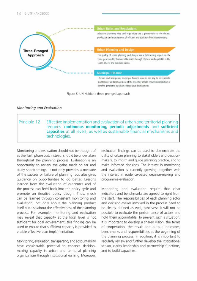
18 IG-UTP HandBook
Monitoring and Evaluation
Monitoring and evaluation should not be thought of as the ‘last’ phase but, instead, should be undertaken throughout the planning process. Evaluation is an opportunity to review the gains made so far and study shortcomings. It not only provides a measure of the success or failure of planning, but also gives guidance on opportunities to do better. Lessons learned from the evaluation of outcomes and of the process can feed back into the policy cycle and promote an iterative policy design. Thus, much can be learned through consistent monitoring and evaluation, not only about the planning product itself but also about the effectiveness of the planning process. For example, monitoring and evaluation may reveal that capacity at the local level is not sufficient for goal achievement; this finding can be used to ensure that sufficient capacity is provided to enable effective plan implementation.
Monitoring, evaluation, transparency and accountability have considerable potential to enhance decision-making capacity in urban and territorial planning organizations through institutional learning. Moreover,
evaluation findings can be used to demonstrate the utility of urban planning to stakeholders and decision-makers, to inform and guide planning practice, and to make informed decisions. The interest in monitoring and evaluation is currently growing, together with the interest in evidence-based decision-making and programme evaluation.
Monitoring and evaluation require that clear indicators and benchmarks are agreed to right from the start. The responsibilities of each planning actor and decision-maker involved in the process need to be clearly defined as well, otherwise it will not be possible to evaluate the performance of actors and hold them accountable. To prevent such a situation, it is important to develop a shared vision, the terms of cooperation, the result and output indicators, benchmarks and responsibilities at the beginning of the planning process. In addition, it is important to regularly review and further develop the institutional set-up, clarify leadership and partnership functions, and to build capacities.
Principle 12 Effective implementation and evaluation of urban and territorial planning requires continuous monitoring, periodic adjustments and sufficient capacities at all levels, as well as sustainable financial mechanisms and technologies.
Figure 6: UN-Habitat’s three-pronged approach

19IG-UTP HandBook
• Studies (including feasibility), data and information used for the prognosis and the development of scenarios should be verifiable and publicly accessible.
• All stakeholders should be invited to contribute to all phases of the production of plans and related cooperation by submitting their own verifiable data and information. Locals are often closer to the problem and have insights otherwise not available. In countries with a highly centralized planning system, in particular local insight can make a difference and reduce the costly consequences of mistakes in planning.
• Standards for transparency and accountability should always be applied in the implementation of plans. In the case of city councils and parliaments, they should particularly undertake continuous monitoring of project implementation.
• Further, forms of citizen audits and evaluations by independent planning professionals can help to improve transparency and accountability, and to strengthen ownership.
3.3 conclusIon
This chapter described planning as a process, as well as its components, phases and how the process is governed. It demonstrates that integrated and participative planning is not only necessary to promote local democracy, participation and inclusion, transparency and accountability, but that it is also a pre-condition for informed decision-making and effective planning. The first key message emerges from this chapter, which is that it is only through such an integrative approach and the provision of inputs on behalf of all stakeholders that the risk of planning failure can be minimized.
The second key message is that planning phases are iterative and not necessarily linear. Monitoring and evaluation may identify deficits, which in turn require another look to improve diagnosis and plan formulation or to improve capacities for the implementation. And, of course, as a decision-making process, there is not only one decision to be taken (e.g. a plan’s approval by the city council), but instead, each phase includes numerous decisions defining the process.

20 IG-UTP HandBook
checklist for the process for integrated and participative planning
o Promote the use of urban and territorial planning as a facilitating and flexible mechanism rather than as a rigid blueprint. Plans should be elaborated in a participatory way and their various versions made accessible and user-friendly, so that they are easily understood by the population at large;
o Develop a shared strategic spatial vision (supported by adequate maps) and a set of consensual objectives, reflecting a clear political will;
o Link upstream planning and downstream implementation and ensure consistency between long-term objectives and programmes and short-term managerial activities and sector projects;
o Set up multi-stakeholder monitoring, evaluation and accountability mechanisms to transparently evaluate the implementation of the plans and provide feedback and information on suitable corrective actions, covering both short- and long-term projects and programmes; approve and keep under continuous review and update [statutory] urban and territorial plans;
o Effectively supervise professionals and private companies contracted for urban and territorial planning preparation, to ensure the alignment of plans with local political visions, national policies and international principles;
o Empower and capacitate citizens and their civil society organizations to participate in the preparation, implementation and monitoring of urban and territorial plans, help local authorities identify needs and priorities and, wherever possible, exercise their right to be consulted in accordance with existing legal frameworks and international agreements; Contribute to the mobilization and representation of populations in public consultations on urban and territorial planning, particularly poor people and vulnerable groups of all ages and gender, with a view to fostering equitable urban development, promoting peaceful social relations and prioritizing the development of infrastructure and services in the least developed urban areas; provide feedback to the authorities on challenges and opportunities that may emerge in the implementation phases and recommend necessary adjustments and corrective measures;
o Encourage planning professionals and their associations to facilitate urban and territorial planning processes by providing technical assistance for the implementation of different types of plans and supporting the collection, analysis, use, sharing and dissemination of spatial data;
o Undertake on-the-job training and applied research associated with the implementation of the plans, with a view to learning from practical experience and providing substantive feedback to decision-makers;
o Design and organize training sessions for policymakers and local leaders to sensitize them to urban and territorial planning issues, particularly the need for continuous and long-term implementation and accountability;
o Document planning models which could be used for educational purposes, awareness-raising and the broad mobilization of the public.

21IG-UTP HandBook
4. tHe Products: Policies, plans, and designs

22 IG-UTP HandBook
The planning process generates different kinds of products. These products, in the form of policies, plans and designs, are at the centre of this chapter. It describes the kinds of plans which exist at the supranational/transboundary, national, city-regional, city-wide and neighbourhood level, and in doing so, it follows the structure of the planning phases of diagnosis, formulation, implementation and evaluation as described in Chapter 3. The need for regular assessments of planning and planning systems is described towards the end of the chapter.
4.1 wHat KInd of Plans?
Outputs or products of planning processes can be policies, plans and designs, but what they look like varies according to the planning scale with their different functions and competences. It is a strength of the guidelines that they are applicable throughout the multiscale continuum of territorial planning, i.e. at:
- Supranational and transboundary level - National level - City-regional and metropolitan level - City-wide and municipal level - Neighbourhood level
One of the unique selling points of the guidelines is the full territorial scope on the urban- rural continuum, including big wide-open spaces of oceans, seas, lakes, rivers or uncultivated lands – deserts, mountains, forests, grasslands and barren lands. The complementarity of planning levels, including the urban-rural continuum and thematic plans, does not work (any longer) as the stereotypical, top-down pyramid or as a series of cascade plans with a perfect fit as a Russian mathryoshka. While the five planning levels identified in the guidelines can be schematically presented as part of a comprehensive linear planning process, in reality, policies, plans and designs are usually developed in a more complex manner and relate to each other in multiple ways.
For instance, a new or reviewed national urban policy (NUP) or spatial framework will spark new planning initiatives or adjustments at the regional and local levels. Likewise, outdated national and regional plans should be challenged by new or reviewed city-wide and neighbourhood plans. In that sense, legal provisions related to the so-called ‘plan conformity’ with higher level plans should be held against the need for ‘plan flexibility’ and legitimate bottom-up ‘deviations’. This is also in alignment with the good governance principle of subsidiarity: each scale plan can and should contain elements of all other planning levels, but needs to be specific and selective about what the plan can do to strengthen territorial cohesion and performance of that specific level. For example, a local city plan can suggest new regional and national infrastructure but should decide and act to improve and complement the urban-municipal street and transport network. Conversely, national or regional plans can suggest and/or trigger local improvement strategies and interventions. However, national and regional planners should still decide on investments in infrastructure and ecosystems of national importance while making funds and grants available to foster local change.
With this in mind, some basic characteristics of each planning scale can be further explored from the perspective of complementarity and aligned with the subsidiarity principle to plan the right features at the right scale.
4.2 PolIcIes, Plans and desIGns at fIve PlannInG scales
This subchapter explores the characteristics of and complementarity between the five basic planning scales (or levels) referenced in the guidelines, expanded through a category of area and theme-specific planning scale.

23IG-UTP HandBook
4.2.1 Supranational and transboundary planning
At supranational and transboundary level, multinational regional strategies could help direct investment to address global issues such as climate change and energy efficiency, enable the integrated expansion of urban areas in cross-border regions, mitigate natural risks and improve the sustainable management of shared natural resources.
IG-UTP, Section IB.
Supranational and transboundary planning became a major issue at the beginning of the 1990s when political changes, especially in Europe, and economic developments in a globalizing world stimulated the need for long-term vision and transnational territorial planning. This was the case, for example, for the countries in the Baltic Sea Region after the fall of the Iron Curtain. There, in 1992 at a conference in Karlskrona, Sweden, ministers produced the document Vision and Strategies for the Baltic Sea Region 2010, which included a set of 14 goals for sustainable territorial development in the region. Later, it stimulated the development of the European Spatial Planning Observatory Network (ESPON) that was needed to address data-gathering challenges, data-interpretation and mapping issues, among others. Until then, these had been obstacles to the integration of data from different countries that compiled it under different standards and methodologies. Today, the European Spatial Development Perspective is a rare example of a (partial) continental territorial plan.
In a similar way, there are growing pockets of regional cooperation, such as the Greater Mekong Subregion Economic Cooperation Programme connecting China with South-East Asia and South Asia. Countries which have formulated development strategies with elements of transboundary cooperation include South Korea, which defined supra-economic regions in its 4th Comprehensive National Territorial and Development Plan, and Malaysia, which developed the Iskandar Comprehensive Development Plan for the South Johor Economic Region (SJER).
Shared principles and vision statements are always at the centre of supranational and transboundary planning, while the implementation is often the responsibility of national institutions. Since no planning and decision-making competences are transferred to the supranational or transboundary level, there is always a need for clear referencing to formal planning frameworks and plans from the partner countries. Collective informal decision-making (e.g. approval of the Baltic Sea vision and strategy at a ministerial conference) is to be followed by more formal endorsements on behalf of all the constituents.
Supranational and transboundary planning are still in an exploratory phase and need to be given more attention to be able to integrate policies, plans and designs across national boundaries. Thus, for the time being, there is often an absence of planning authorities and competences assigned to levels beyond the national level. Consequently, each supranational and transboundary territorial plan needs to define its own institutional and regulatory environment for the diagnostic, plan formulation, implementation, and monitoring and evaluation.
4.2.2 National planning
At the national level, national plans could take advantage of existing and planned economic poles and large infrastructure in order to support, structure and balance the system of towns and cities, including in urban corridors and river basins, to fully unleash their economic potential.
Guidelines, Section IB.
The content and political power linked to national territorial planning depends on national legislation, which usually holds a holistic and comprehensive scope on the national territory. Typically, it is accompanied by maps to indicate which cities are preferred as national growth-poles, combined with a rough indication of the spatial layout of the connecting multimodal corridors and not necessarily defining the routing of new infrastructure -

24 IG-UTP HandBook
infrastructure which is too often defined with the collaboration of subnational authorities and communities in lower-tier plans.
National territorial plans (NTPs), such as the Korean National Territorial and Regional Development Policy focusing on a comprehensive national territorial plan, are also important to seek territorial balance between urban, rural and natural areas, including urban-rural territorial links and partnerships. Thus, it may be deduced that public participation is a real challenge and requires innovative approaches to ensure a two-way planning process and public access to information, combined with innovative communication and outreach methods. Lastly, area or theme-specific national territorial strategies can complement NTPs and NUPs.
National spatial planning addresses subjects relevant for cities, like the city system of a territory or the connections between cities. Nonetheless, it requires a separate NUP as a coherent set of decisions derived through a deliberate government-led process of coordinating and rallying various actors for a common vision and goal that will promote more transformative, productive, inclusive and resilient urban development for the long term (UN-Habitat, 2014).
4.2.3 City-regional and metropolitan planning
At city-region and metropolitan level, subnational regional plans could foster economic development by promoting regional economies of scale and agglomeration, increasing productivity and prosperity, strengthening urban-rural linkages and adaptation to climate change impacts, reducing disaster risks and intensity in the use of energy, addressing social and spatial disparities and promoting territorial cohesion and complementarities in both growing and declining areas.”
Guidelines, Section IB.
There is a wide range of planning frameworks and approaches at the city-region and metropolitan levels. Federal states are more likely to have regional planning with clearly defined competences, legislative and financial frameworks. However, even in federal government structures, like that of Germany, new definitions of city-regions and metropolitan areas often emerge that are driven by common challenges and opportunities for planning. For instance, the Stuttgart Region is an administrative district but not a German region with a constitutional status. Nonetheless, the Stuttgart Region has a directly elected council, which is in charge of regional planning. Metropolitan cities or metropolitan areas with multiple jurisdictions and municipalities are becoming ‘the new normal’. Therefore, city-region and metropolitan planning will need to accommodate a great deal of future urbanization. As such, areas continue to emerge and grow and the need for metropolitan-level management increases (GIZ and UN-Habitat, 2015). Over the next 20 years, metropolitan planning will become a major planning challenge and opportunity, which will encompass an expanding city-region scale from 4 million to 25 million large metropolises, and 25 million to 150 million large ‘megalopolises’ like China’s Hong Kong-Shenzhen-Guangzhou Pearl River Delta mega-region, which is now home to 120 million inhabitants (UN-Habitat, 2016). In this context, planning actors and stakeholders will also need frameworks for metropolitan governance that act beyond administrative boundaries of the core city, urban-rural linkages and partnerships. To address the problems of growing communities, city-region systems will be needed, for, for example, sustainable transport and mobility. Likewise, basic services, such as the provision of water, may become a subject for planning at the level of the city-region or metropolitan area.

25IG-UTP HandBook
4.2.4 City-wide and municipal planning
At city and municipal level, city development strategies and integrated development plans could prioritize investment decisions and encourage synergies and interactions between separate urban areas. Land-use plans could contribute to the protection of environmentally sensitive areas and to the regulation of land markets. Urban extension and infill plans could minimize transport and service delivery costs, optimize the use of land and support the protection and organization of urban open spaces. Urban upgrading and retrofitting plans could increase residential and economic densities and promote more socially integrated communities.”
Guidelines, Section IB.
Practical experience in planning supports the claim that cities and municipalities are better equipped for the future with flexible strategic territorial plans than with static blueprint masterplans. While plans with a comprehensive set of strategic themes for the entire territory of cities and municipalities are still valid, more and more cities are complementing or even substituting this approach with the use of theme- or area-specific territorial plans and strategies, such as resilience action plans, climate-change mitigation plans, urban densification and extension plans, etc. However, this multi-planning approach requires a multi-sectorial and multi-stakeholder city-wide or municipal territorial policy to ensure unity in diversity.
City-wide plans should reference and draw on metropolitan, city-region, region and national plans, if any. Moreover, the plans’ formulation should be accompanied by an implementation strategy with links to the needed legal and financial provisions for implementing measures and projects. In addition, monitoring and evaluation of the formulated plan is key throughout the implementation phase, with feedback loops and partial revisions where needed and justifiable. City-wide plans should be monitored along the baseline and development indicators and reviewed and reformulated on a regular basis, for example every five to ten years.
4.2.5 Neighbourhood planning
“At neighbourhood level, street development and public space plans and layouts could improve urban quality, social cohesion and inclusion, and the protection of local resources. Participatory planning and budgeting, involving communities in managing urban commons, such as public spaces and services, could contribute to improved spatial integration and connectivity, human security and resilience, local democracy and social accountability.”
Guidelines, Section IB.
Neighbourhood-level territorial planning is the closest to the citizen and community needs to be formulated for and with the people living in a particular neighbourhood. By activating the local knowledge of a community, residents prove to be the best experts of their own built environment. A number of diagnostic tools, such as memory mapping and storytelling, reconnaissance trips, SWOT analysis and strategies, are available for the community level but need to be well tailored to the local context. As tested in multiple placemaking interventions, where public places are (re)developed along with the neighbourhood, it is crucial to combine both the survey of the physical features of the area with an in-depth understanding of the social landscape – the emotional capital of a place.
Similar to city-wide plans, neighbourhood plans should also contain an implementation strategy inclusive of (suggested) legal and financial provisions. Obviously, neighbourhood plans and designs should clearly reference and draw on city-wide or municipal plans, but can also address changes to these plans if deemed mutually beneficial and necessary to implement the neighbourhood plan or design scheme. Lastly, public spaces and planned city-extensions are special cases of neighbourhood planning, but also require a tailor-made planning approach.

26 IG-UTP HandBook
4.2.6 Area-specific and thematic planning
In addition to the five planning levels defined by the guidelines, a category of diverse ‘area-specific and/or purpose-specific plans’ is suggested to address specific territorial focus areas such as special economic zones (SEZ), river basins, tourist zones (e.g. ski and beach resorts), mining areas, power plants and renewable energy sites, historic districts, archaeological sites, national parks and nature reserves, among others. These themes can be addressed by planning at different scales. While a SEZ is confined in space, it is usually an initiative driven by national or regional level actors. The same goes for power plants, mining areas and national parks, often overruling local land-use plans, if any. A dedicated summer or winter tourist resort could be developed in only one municipality, but entirely planned and managed by a regional or national authority. Very often, the national planning system includes provisions on planning proposals and projects of national importance with a set of specific rules and procedures for planning, implementation and management. Still, there are also other possible cases of area-specific planning. Three or four rural municipalities might join hands to develop a landscape plan to preserve natural heritage and unspoiled vistas; the plan needed might be called a landscape or natural heritage preservation plan and does not need to be enshrined in planning legislation. After completion and joint approval, the plan could be used to review existing statutory municipal land-use plans.
Therefore, while the five planning levels covered by the guidelines touch on most of the planning activities and outputs, flexibility and adaptability are required to address territorial challenges and opportunities that go beyond or cut through the five basic levels. Area and purpose-specific plans and designs will require similar processes or a mix of these inherent to the five basic levels, but in a customized way. Despite their specific area or purpose, it is important that area and purpose-specific plans should not exist independently or even in contradiction of planning at the five planning scales, but that policy coherence with other integrated and participative plans and planning processes is assured.
4.3 revIew of PlannInG systems
What do we mean by the ‘planning system’?
Under the frame of the IG-UTP and the handbook, the planning system is defined as the localized multi-tier and multi-partner governance framework for formulating, developing and/or improving urban and territorial policies, plans, designs and implementation processes, aimed at more compact, socially inclusive, better integrated and connected, and climate resilient cities and territories. In addition, the planning system should also be considered as the combined performance of ‘planning in theory’ and ‘planning in practice’. Moreover, the handbook is designed to bridge the application of the global principles to local contexts. This approach intends to explore the role of both national and subnational planning systems as the stage for bringing together all the components of the guidelines.
Why should urban and territorial planning be reviewed?
There are many reasons why a planning system review may be necessary within a specific context. For example, a majority of countries have very old planning systems that do not respond to the challenges of the rapidly urbanizing twenty-first century or changing political-economic social contexts. In addition, there are many cases where the planning system only refers to formal planning while most urbanization occurs outside of it. One or several entry points to the planning system (a sectorial issue, a weak process or product) are also valid reasons to motivate for its adjustment, or for considering a reform that moves from ad-hoc interventions or analysis of strengths, weaknesses, opportunities and challenges (SWOT) to a more systematic and forward-looking adjustment of the planning system. Whatever the reason, one or more of these situations is enough to get started.

27IG-UTP HandBook
Planning review methodology
Overall, the planning review methodology intends to review existing planning approaches, instruments and other components of the overall planning system in place to identify gaps, opportunities and deficiencies, and to serve as a baseline for planning review and reform. By becoming well-informed about the issues in the planning system, planning constituencies can be better equipped to translate the results of the assessment into actions (roadmap) towards the reform and its consequent improvement of the planning system. Although UN-Habitat has developed an indicative methodological approach to carry out the review, each country or city can organize it according to local best practices, inspired by international best practices.
Types of review:
Planning system review (rapid & comprehensive). This type of review intends to assess the local planning approach and system of a city or country as a whole against the principles and recommendations provided in the guidelines. The assessment will allow for the identification of existing gaps and deficiencies, and the identification of potential areas for improvement of the planning system, serving as a baseline for later planning review and reform.
Review of policies, plans, and designs. Based on the guidelines’ goal “to improve policies, plans, designs and implementation processes, which will lead to more compact, socially inclusive, better integrated and connected cities and territories that foster sustainable urban development and are resilient to climate change” (p. 1), the review of planning products is in line with the five qualifiers of sustainable urban development established by UN-Habitat. The review also takes into account cross-cutting issues such as gender, youth and human rights, and, lastly, it is based on a multi-scale approach, meaning that the products are evaluated depending on their working level (whether supranational, national, regional, metropolitan, city or neighbourhood level).
4.4 conclusIon
In the phases of production and realization of policies, plans and designs, visions, strategies and planning goals take shape and transform cities and territories. Where the scope, competences and resources are well-defined, the different scales of planning complement each other. Nonetheless, rapid urbanization and other dynamics generate new situations, challenges and opportunities. Therefore, the review of planning processes and the systems themselves is a constant challenge to find even better ways to achieve integrated and participative planning.
With respect to the content of plans, there is a general distinction that planning products at the higher levels are more holistic and comprehensive while those at the city or neighbourhood level are more specific. Nonetheless, any planning theme at the neighbourhood or city scale may be addressed also at the national or supranational level if its related challenges and opportunities also have a national or supranational relevance. It is in this context that the guidelines were formulated in a way that they are applicable not only at the local level but throughout the multi-level continuum of territorial planning; i.e. from the supranational to the neighbourhood level.

28 IG-UTP HandBook
checklist on policies, plans and designs of integrated and participative planning
Planning products and their content
o Elaborate and articulate urban and territorial plans that include multiple territorial components such as:
•A set of development scenarios, based on a thorough analysis of demographic, social, economic and environmental trends, that take into account the critical linkages between land use and transport; that engage planning professionals and their associations in translating forecasts and projections into planning alternatives and scenarios to enable political decisions;
•A clear prioritization and phasing of desired and achievable territorial outcomes along adequate time lines and based on appropriate feasibility studies;
•Territorial plans that reflect the scale of projected urban growth and address it through planned city extensions, urban infill and redevelopment for adequate density, and through the structuring of well-connected systems of liveable streets and high-quality public spaces;
•Territorial plans that have environmental conditions as their base, that prioritize the protection of ecologically valuable areas and disaster-prone areas and that focus particularly on mixed land use, urban morphology and structure, mobility and infrastructure development, leaving room for flexibility to address unforeseen evolutions;
o Promote environmentally sound technologies, geospatial technologies for data collection, information and communications technologies, street addressing, land registration and property recording systems, as well as networking and knowledge sharing to support technically and socially the implementation of urban and territorial plans;
o Promote social and territorial integration and inclusion, particularly through improved access to all parts of the city and territory, as every inhabitant (including migrant workers and displaced people) should have the ability to enjoy the city, its socioeconomic opportunities, urban services and public spaces, and to contribute to its social and cultural life;
o Formulate urban and territorial plans as a mitigation and adaptation framework in response to climate change and for increasing the resilience of human settlements, especially those located in vulnerable and informal areas;
o Ensure that urban and territorial plans address the need to develop sustainable energy services, with a view to improving access to clean energy, reducing the consumption of fossil fuel and promoting appropriate energy mixes, as well as energy efficiency in buildings, industries and multimodal transport services; set up and adopt efficient low-carbon urban forms and development patterns as a contribution to improving energy efficiency and increasing the access and use of renewable energy sources;
o Collaborate with service providers, land developers and landowners to closely link territorial and sector planning and to promote inter-sector coordination and synergies between services such as water, sewerage and sanitation, energy and electricity, telecommunications and transport; locate essential urban services, infrastructure and residential developments in low-risk areas and resettle, in a participatory and voluntary way, people living in high-risk areas to more appropriate locations;

29IG-UTP HandBook
o Collaborate with service providers, land developers and landowners to closely link territorial and sector planning and to promote inter-sector coordination and synergies between services such as water, sewerage and sanitation, energy and electricity, telecommunications and transport; locate essential urban services, infrastructure and residential developments in low-risk areas and resettle, in a participatory and voluntary way, people living in high-risk areas to more appropriate locations;
o Ensure that low-income areas, informal settlements and slums are upgraded and integrated into the urban fabric with the minimum disruption of livelihoods, displacements and relocations. Affected groups should be compensated at the appropriate level when disruption is unavoidable;
o Integrate solid and liquid waste management and recycling into territorial planning, including the location of landfills and recycling sites;
o Apply urban and territorial planning to identify, revitalize, protect and produce high-quality public and green spaces with special ecological or heritage value, integrating the contributions of the private sector and civil society organizations into such undertakings and, to avoid the creation of heat islands, protect the local biodiversity and support the creation of multifunctional public green spaces, such as wetlands for rainwater retention and absorption;
o Reduce commuting time between living, working and service areas by promoting mixed land use and safe, comfortable, affordable and reliable transport systems, and by considering variations in land and housing prices in different locations and the need to promote affordable housing solutions;
o Create favourable conditions to develop safe and reliable mass transit and freight transport systems, while minimizing the use of individual vehicles in order to facilitate urban mobility in an energy-efficient and affordable way;
o Constitute the mandatory basis for efficient trunk infrastructure development, improved mobility and the promotion of structuring urban nodes;
o Secure adequate space for streets, in order to develop a safe, comfortable and efficient street network, allowing a high degree of connectivity and encouraging non-motorized transport, in order to enhance economic productivity and facilitate local economic development;
o Contribute to increased, balanced and affordable access to digital infrastructure and services for economic actors and inhabitants, and to the development of knowledge-based cities and territories;
o Identify and recognize the value of declining built environments with a view to revitalizing them, taking advantage of their assets and strengthening their social identity;

30 IG-UTP HandBook
designs
o Design neighbourhoods of adequate density through infill or planned extension strategies to trigger economies of scale, reduce travel needs and the costs of service provision, and enable a cost-effective public transport system;
o Design streets that encourage walking, the use of non-motorized transport and public transport, and plant trees for shade and carbon dioxide absorption;
o Provide good quality public spaces, improve and revitalize existing public spaces, such as squares, streets, green areas and sports complexes, and make them safer, in line with the needs and perspectives of women, men, girls and boys, and fully accessible to all. It should be taken into account that those places constitute an indispensable platform for vibrant and inclusive city life and are a basis for infrastructure development;
o Improve urban safety, particularly for women, youth, the elderly, the disabled and any vulnerable groups, as a factor of security, justice and social cohesion;
o Promote the construction, retrofitting and management of green buildings through incentives and disincentives, and monitor their economic impacts;
o Promote and ensure gender equality in the design, production and use of urban spaces and services by identifying the specific needs of women and men, girls and boys;
o Encourage cultural activities, both indoor (museums, theatres, cinemas, concert halls, etc.) and outdoor (street arts, musical parades, etc.), recognizing that the development of urban cultures and respect for social diversity are part of social development and have important spatial dimensions;
o Make space for, encourage and enable all sectors of society, particularly poor people and vulnerable groups of all ages and gender, to engage in community forums and community planning initiatives and to partner with local authorities in neighbourhood improvement programmes.

31IG-UTP HandBook
5. tHe outcomes: fostering sustainable urban and territorial development

32 IG-UTP HandBook
This chapter is about the environmental, social and economic impacts of planning for sustainable urban and territorial development. It describes sustainable development as a central outcome of urban and territorial planning following the five primary qualifiers of the overall aim for more sustainable urban and territorial planning and development: planning compact, inclusive, connected, resilient and integrated places.
5.1 sustaInable develoPment as an outcome of urban and terrItorIal PlannInG
The International Guidelines on Urban and Territorial Planning were approved just a few months ahead of the Agenda 2030, and framed in alignment with the SDG’s three dimensions of sustainable development: the social, economic and environmental pillars, combined with the urban policy and territorial governance. When
the Member States of the United Nations adopted the Agenda 2030 including its 17 SDGs in September 2015, not all indicators for implementation were clear and the discussion at the UN and within Member States on how the goals should be localized and achieved was still on-going. It was under this situation that the Governing Council of UN-Habitat with its approval of the Guidelines aimed at the IG-UTP “as a valuable guide that may be used towards the achievement of sustainable development”. Therefore, the Guidelines are well suited for this purpose as six out of their twelve principles focus directly on social development, economic growth and the environment.
Principles 1, 2 and 9 to 12 as discussed in Chapter 3 of this handbook mainly focus on the process of planning and occasionally highlight its outcomes (e.g. according to Principle 9, urban and territorial planning aims to “promote more compact cities” and “synergies between territories”). Yet, the second group of principles is different. Principles 3 to 8 address urban and territorial planning in relation to intended development and its outcomes.
Urban and Territorial Planning and Social DevelopmentPrinciple 3 Urban and territorial planning primarily aims to realize adequate standards of living and
working conditions for all through social inclusion and cohesion, recognizing the distinct needs of various groups.
Principle 4 Urban and territorial planning is a precondition for a better quality of life and successful globalization processes that respect cultural heritages and cultural diversity.
Urban and Territorial Planning and Sustained Economic Growth
Principle 5 Urban and Territorial Planning provides an enabling framework for new economic opportunities, regulation of land and housing markets and timely provision of adequate infrastructure and basic services.
Principle 6 Urban and territorial planning provides a mechanism to ensure that sustained economic growth, social development and environmental sustainability go hand in hand to promote better connectivity at all territorial levels.
Urban and Territorial Planning and the EnvironmentPrinciple 7 Urban and territorial planning provides a spatial framework to protect and manage the natural
and built environment of cities and territories, including their biodiversity, land and natural resources.
Principle 8 Urban and Territorial Planning contributes to increased human security by strengthening environmental and socioeconomic resilience, enhancing mitigation of, and adaptation to, climate change.

33IG-UTP HandBook
• To develop a universally applicable reference framework to guide urban policy reforms;
• To capture universal principles from national and local experience that could support the development of diverse planning approaches adapted to different contexts and scales:
• To complement and link to other international guidelines aimed at fostering sustainable urban development;
• To raise urban and territorial dimensions of the development agendas of national, regional and local governments
An outcome is the combined effect of the socioeconomic and environmental changes (products) brought about by the planning system (the long-term), but the distinction between products and outcomes is a thin line. Outcomes are not the end of development, but they stimulate new processes and new products leading to new outcomes. Therefore, it is important to understand that the guidelines do not aim at sustainable development as an end product of urban and territorial development. Instead, in response to the rapid urbanization (especially in developing economies), other urban and territorial trends and related economic, social and environmental impacts, the goals of the guidelines are:
How to foster sustainable territorial development in the day-to-day work of planners?
Sustainable development is a complex challenge but not every process and product of urban and territorial planning must lead to sustainability. Instead, it is crucial that the combined effect of the socioeconomic and environmental changes brings us closer to sustainable development and use of the territory.
As a self-check for planning actors and stakeholders, it may be helpful for them to read the 12 principles of the guidelines regularly and to reflect on the extent to which their own efforts in relation to planning are in line with the overall aim of combined effects fostering sustainable urban and territorial development. If their own processes, products and outcomes are not in line or they even contradict one or more of the principles, an adaption of their own approach and work should be considered.
A second step could be to use UN-Habitat’s questionnaires (see 4.3) to make a self-assessment of planning. See also Chapter 6 of this handbook for additional recommendations.

34 IG-UTP HandBook
5.2 wHat does PlannInG need to acHIeve? tHe maIn aIm and Its fIve qualIfIers
According to UN-Habitat (2015), five qualifiers have been identified:
Planning Compact, Inclusive, Connected, Resilient and Integrated places
In the following sections, the handbook unpacks and defines the five primary qualifiers of the overall aim for more sustainable urban and territorial planning and development. However, the five qualifiers should be treated as inter-dependent and as targets to adjust local and national planning to these global quality standards.
5.2.1 Planning more compact places
While a product of the planning process is adequate density, the corresponding intended outcome would be compact cities. The aim to promote more compact cities and synergy between territories is not only mentioned in principle 9 but also repeatedly throughout the guidelines. ‘More compact’ puts emphasis on a sustainable urban form (shape, density and land use) that reduces the over-exploitation of natural resources - often related to ‘urban sprawl’, promotes economic viability, liveability, environmental quality and social equity.
The benefits of compact urban settlements over urban sprawl are multiple and diverse:
• Greater efficiency in the use of land and so a positive impact on a city’s spatial and ecological footprint, with the added benefits of:
− Reduction in reliance on cars, thus lower emissions;
− Reduced energy;
− Lower impacts of urban growth on rural and agricultural lands;
− The preservation of green space;− Lower non-renewable resource
consumption.
• Higher population and economic thresholds, with the added benefits of:
− Increased overall accessibility to services and amenities;
− Viable and effective public transport provision based on sustainable population thresholds to support the service;
− Harnessing of agglomeration advantages and creation of a milieu for enhanced business and trading activities;
− Reduction of time and cost spent travelling due to shortened distances to destinations;
− Increased social inclusiveness and reduction in social segregation through designing quality mixed-use areas;
− The re-use of infrastructure and previously developed land and the regeneration of existing urban areas and urban vitality and;
− Overall quality of urban life.
5.2.2 Planning socially more inclusive places
Social inclusion as addressed by the principles 3 and 4 and, repeatedly throughout the guidelines is a vital concept in urban and territorial planning, where planning is seen as a way to promote the equitable distribution of costs, benefits and opportunities of urban development. The proportion of people living in slums and poor informal settlements (SDG 11.1), social mix of housing, the availability of secure tenure and the promotion of cultural heritage are all parameters indicating the ways in which different social groups have been included within the design of urban areas. This is often referred to as ‘right to the city’.

35IG-UTP HandBook
It promotes the concept of Participatory Planning which is not limited to the integration of stakeholders with more influence, but also the integration of all stakeholders with a particular focus on the needs of women and those who are most vulnerable, including, inter alia, children and youth, older people, people with disabilities, the poor, the landless, rural to urban migrants, internally displaced people and Indigenous Peoples, in the plan-making process so as to effectively impact their lives. Therefore, ‘more inclusive’ suggests promoting growth with equity, where everyone, regardless of their economic means, gender, race, age, ethnicity or religion, is enabled and empowered to fully participate in the social, economic and political opportunities that cities have to offer. Access to information and planning documents in particular is a tool that measures the transparency of plans and planning processes.
Participatory planning and decision-making (principle 1) are at the heart of the ‘inclusive norm’ and have, amongst others, the following benefits:
• Reduces inequality and social tension;• Incorporates the knowledge, productivity,
social and physical capital of the poor and disadvantaged in city development;
• Increases local ownership of the development processes and programmes;
• Everyone is ready – in terms of gender and age anyone can join in the planning process. They do not need to fulfil any criteria or meet certain conditions;
• Everyone can learn and support – youth and gender groups can learn from the planning process and can contribute positively.
Socially inclusive cities and towns are not only about public participation for all. Both the SDGs and NUA address specific issues to achieve more social cohesion between and within territories, such as:
− Reduce inequality within and among countries (SDG 9);
− By 2030, ensure access for all to adequate, safe and affordable housing and basic
services and upgrade slums (SDG 11.1);− By 2030, provide universal access to safe,
inclusive and accessible, green and public spaces, in particular for women and children, older persons and persons with disabilities (SDG11.7);
− Support positive economic, social and environmental links between urban, peri-urban and rural areas by strengthening national and regional development planning (SDG11.a).
The role of public spaces as promoters of equity and social inclusion is one of the subjects addressed by UN-Habitat’s (2015) Global Public Space Toolkit From Global Principles to Local Policies and Practice. The toolkit is a practical reference for local governments to frame and implement principles, policy recommendations and development initiatives on public space and for central governments to aid their efforts with material support and enabling legislation. It will also demonstrate the value of the involvement of the citizenry and civil society in securing, developing and managing public space in the city.
5.2.3 Planning better connected places
Connectivity is probably what defines cities and humanity overall. In this context the aim of principle 6 of the guidelines of ‘better connectivity’ involves the development and implementation of policies, plans and designs that provide better physical, virtual and social connectivity among people living in different cities and territories. It includes (trans) national policies to connect metropolises and other economic centres around the globe through gateways (sea-, air- and digital mainports) and (multimodal) corridors, complemented by national and regional policies and plans to connect with and interconnect all other urban centres. Houses and their residents need to be connected to (basic) urban services – water, sanitation, energy, healthcare and education - and streets at neighbourhood level, while city-wide and municipal planning need to ensure connectivity between neighbourhoods and the settlements in the hinterland. In other words: connectivity is everywhere – from global to street level.

36 IG-UTP HandBook
However, connectivity is more than providing infrastructure – the ‘hardware’. The ‘software’ and ‘orgware’ (Dobrov, 1979) are as important. The software is about how we make best use of the infrastructure: cars and lorries or (cargo) trains, buses and cable-cars; metro or bus rapid transit; driving or walking and cycling; commuting or tele-working; basic or luxury urban services; fossil-fuel powered or renewable energy; manicured and surveyed or creative and socially controlled public spaces, etc. The orgware finally is the organizational capacity to run and manage the connectivity – e.g. a metropolitan public transport authority, a telcom and internet provider, a city-freight-distribution centre; but also a sensitization campaign to promote non-motorized transport, a mobility research centre, etc. In that sense, ‘connectivity policy’; is much larger than ‘infrastructure policy’ or even ‘mobility policy’: a wise combination or hard/soft/orgware can add high value to supply-demand chains between different parts of the world or between and within cities.
Goal 11 – ‘Make cities and human settlements inclusive, safe, resilient and sustainable’ – complements these infrastructural goals with commitments such as:
− By 2030, provide access to safe, affordable, accessible and sustainable transport systems for all, improving road safety, notably by expanding public transport, with special attention to the needs of those in vulnerable situations, women, children, people with disabilities and older people” (SDG 11.2), with the proportion of the population that has convenient access to public transport as proposed indicator; complemented by NUA commitments on sustainable mobility;
− By 2030, provide universal access to safe, inclusive and accessible, green and public spaces, in particular for women and children, older people and people with disabilities” (SDG 11.7).
5.2.4 Planning places that are more resilient to climate change and natural disasters
Climate change as addressed by principles 7 and 8 and by SDG 11 is one of the defining challenges of our time. It is all the more pertinent to incorporate climate resilience into urban and territorial plans since more than 70 per cent of greenhouse gas (GHG) emissions come from cities, and the effects of climate change, particularly extreme weather events, will continue to be felt most by people living in urban and coastal areas.
Climate change mitigation and adaptation, as well as strategies to improve the management of natural and environmental hazards and risks, will always be essential to any planning exercise.
Resilience to climate change recognizes the role of cities in climate change mitigation and adaptation, as well as the potential role cities play as centres of innovation, development and application of new technologies and solutions in the effort to curb, halt, reverse and adapt to global climate change. Resilience to climate change includes policies, strategies, frameworks, plans and designs that promote both; the adaptation to climate change and mitigation of GHG emissions. Adaptation to climate change and mitigation of GHG emissions vary at each scale level and suitable interventions will have to be carefully crafted according to the appropriate level.
Therefore, any policies, plans and designs that promote resilience to climate change would emphasize the following:
• Mainstreaming of urban issues in climate policies, plans and designs, and vice versa, climate-change issues in urban policies, plans and designs;
• Specify the expected climate change effects, based on the available climate-change science and other data, on the spatial scale of policies, plans and designs, i.e. climate-change effects on the national

37IG-UTP HandBook
urban system – regional and metropolitan scale, on the city as a whole and down to the neighbourhood level;
• Include adaptive measures for the expected negative effects of climate change;
• Include mitigation measures for reducing the contributing factors, especially GHG emissions, for climate change;
• Support, where possible, the development, application and scaling of climate friendly and resilience technology, including ecosystem-based adaptation, etc.
Building resilience demands a whole-of-society approach, especially in cities, where the key sectors of local government must be fully engaged and coordinated.
The New Urban Agenda and Guidelines provide guidance on how to operationalise a resilience agenda by providing a positive role for urbanisation - one that connects the physical, social, environmental and economic elements of cities and other territories.
UN-Habitat’s Cities and Climate Change Initiative (CCCI) seeks to enhance the preparedness and mitigation activities of cities in developing countries. It emphasizes good governance, responsibility, leadership, and practical initiatives for local governments, communities, and citizens. Building on UN-Habitat’s long experience in sustainable urban development, the Cities and Climate Change Initiative helps counterparts to develop and implement pro-poor and innovative climate change policies and strategies.
5.2.5 Integrated planning
Planning is too often focussed on one of the three dimensions or on one of the five scales. Throughout the Guidelines it is highlighted repeatedly that part of the value of urban and territorial planning comes from the fact that it is an integrative process that addresses competing interests. It is exactly in the complexity of this integrative process that UN-Habitat founded its in-house Urban Planning and Design Lab, in order to provide assistance to local, regional and
national authorities with urban planning and design.The theme of integration considers the formal mechanisms by which different interests, strategies and visions are incorporated within the planning process. Two critical ‘integrative planning’ parameters can be identified to enable and achieve the four other qualifiers. The first looks at horizontal integration (inter-ministerial and/or inter-municipal cooperation) on strategic issues that cut across administrative boundaries and territorial policy sectors.
The second is multilevel integration – the planning at different scales and the coordination between different tiers of government - expressed through decentralisation and the principle of subsidiarity. The underlying idea is to reduce friction and conflicts between the different (sectorial) stakeholders, to coordinate sector policies, concepts, objectives and actions towards a common goal, to avoid misleading development and capture the inherent synergies.
Therefore, any policy, plan or design that promotes a more integrated approach would emphasise on the following:
• Mobilisation and participation;• Suitable management and organisational
forms at all steering and implementation levels;
• Integration of short-term, medium-term and long-term interventions for positive outcomes toward urban development;
• Interlinking spatial aspects with economic, social, and environmental components to promote sustainable urban development;
• Support the vision for more functional, productive, resilient, inclusive and stable urban area;
• Integration among government, non-government organisations and various stakeholders involved in the urban development process, and;
• Horizontal integration among sectorial policies and public and private sectors activities for sustainable development.
38 IG-UTP HandBook
5.2.6 Outcome indicators
The guidelines recommend that national governments develop and set up robust monitoring, evaluation and accountability systems on urban and territorial planning, combining quantitative and qualitative information and analyses based on indicators designed to track progress in both processes and products, and open to public scrutiny. Indicators are intended and used for descriptive, normative or prescriptive assessments of urban and territorial planning.
For instance, the above mentioned five qualifiers to plan compact, inclusive, connected, resilient and integrated places describe what planning should achieve, but urban and territorial planning needs to indicate what policies, plans and designs have to be realized (output indicators). Based on these, an outcome indicator would be the number of beneficiaries for which some important change has to be achieved in consequence of the outputs (e.g. the number of people living in resilient places).
UN-Habitat’s City Prosperity Initiative (2016) is both a metric and a policy dialogue, which offers cities from developed and developing countries the possibility to create indicators and baseline targets and goals that can support the formulation of long-term plans that are both ambitious and measurable. It not only aims for the integration of new sources of data and the increase in the usefulness of data, but also enables city authorities and local and national stakeholders to identify opportunities and potential areas of intervention for their cities to become more prosperous.
5.3 conclusIons
The chapter discussed challenges related to planning for sustainability. Planning cannot ensure that sustainability will be achieved. Instead, the application of the principles of the guidelines can support the development of diverse planning approaches adapted to different contexts and scales aimed at sustainable development.
To allow monitoring of whether planning is on track towards more sustainable urban and territorial planning, UN-Habitat identified five qualifiers which have been described in the chapter: planning aims at (1) compact, (2) inclusive, (3) connected, (4) resilient and (5) integrated places. The chapter closes with a discussion on outcome indicators.

39IG-UTP HandBook
6. role of un-HabItat & Partners

40 IG-UTP HandBook
The guidelines provide a comprehensive set of issues that need to be considered in the review, development and implementation of urban policies and urban and territorial planning frameworks. An intelligent application of these guidelines can help countries to implement the New Urban Agenda and be better equipped for attaining their Sustainable Development Goals as well as their Intended Nationally Determined Contributions submitted to the United Nations Framework on Climate Change as agreed in Paris in 2015. Resolution 25/6 calls on international financial institutions, development agencies and UN-Habitat to assist interested Member States in using and adapting the guidelines to their territorial and national contexts, where appropriate, and further developing tools and monitoring indicators as part of their support for the implementation of the guidelines.
For an increased uptake of the guidelines, UN-Habitat supports the implementation of the IG-UTP at the global, regional, national and sub-national levels, both directly and through partnerships. In 2016 alone, UN-Habitat engaged with 26 partners in various formats to begin applying the guidelines, efforts that triggered activities in four countries. Broadly speaking, at the global and supra-national regional levels, the focus is on exchange of experience and other forms of knowledge management (developing a database, collecting cases/practices, visit exchanges), tool development, monitoring and reporting, awareness raising, comparative evaluations, policy dialogue and capacity development. At the country and sub-national levels, the focus is on the localized adaptation (national, provincial/state, metropolitan, city levels) of the IG-UTP, the review and adjustment of the legal, regulatory and governance frameworks, and the application of the adapted guidelines to concrete city situations and capacity development.
In addition to a coordination function and tracking and reporting of partner activities, UN-Habitat has been mandated to develop tools and provide technical assistance to enable effective uptake of the guidelines. In order to operationalize them in different local scenarios, UN-Habitat and partners have developed a strategy to localize and implement them. Recognizing that different partners have different needs, the strategy allows for flexible entry points in terms of the (i) leading stakeholder group, (ii) the chosen planning level and (iii)
priority of planning issues. Illustrative planning issues or themes include public space, urban-rural linkages, food systems, health, air quality, urban renewal, diversification of urban patterns, climate change, planned city extensions, city infills and financing for planning. Below is a sample of which type of activities could be implemented and supported at different planning levels:
- At the supranational and transboundary level, it focuses on awareness raising and strengthening global partnerships, knowledge management (including exchange of experiences, database and comparative evaluations), monitoring and reporting.
- At the national level, it focuses on the national adaptation of the IG-UTP, the review and adjustment of the legal and regulatory framework and strengthening strategies of national urban policies, assess and improve urban and territorial planning systems practices.
- At the city-region and metropolitan level, it focuses on activating policy dialogue around integrated urban and territorial governance, building linkages and complementarities among different types and sizes of settlements.
- At the city and municipal level, it focuses on improving the design and implementation of city-wide strategies and strengthening the capacities of local authorities towards more participatory, implementable and sustainable planning practices.
- At the neighbourhood level, it focuses on the application of the adapted guidelines to concrete city situations, improving the design of streets and public spaces, identifying acupuncture and transformative projects and conducting planning tests to integrate design, finance and legal aspects of planning;
Thus, UN-Habitat’s assistance to partners and countries is both normative and operational, as shown in Figure 7 below:
This handbook is one element of a suite of normative products and innovative tools that are being developed to support implementation of the guidelines, with the eventual aim of improving planning practice.

41IG-UTP HandBook
This array of accompanying products and tools will assist all those interested and involved in improving urban and territorial planning approaches, systems and capacities in different contexts. These tools are mainly targeted at the four main categories of stakeholders named in the guidelines: national governments,
Figure 7. UN-Habitat’s implementation framework for the IG-UTP
Improving Knowledge(normative)
Awareness & Advocacy
Documentation & Lessons
Tool Development
Monitoring & Reporting
Building Capacities & Planning Education
Assessment & Review of Planning Systems
Improving Plans & Designs
Policy Dialogue & Engagement
Legal & Regulatory Adjustments
Improving Practice(operational)
Establishing Partnerships(Cross-cutting)
local governments, planning professionals and their associations, and civil society. Examples of some of the tools developed by UN-Habitat are provided here; a more comprehensive listing is available at www.unhabitat.org.
assessment & review of Planning systems• Illustrative tool: Planning System Assessment
This tool offers a methodology to systematically analyse the complex practices and procedures of the planning system. It derives specific benchmarks for evaluating performance from the guidelines. Based on the review of how decision-making processes that impact urban form are currently working, a diagnostic report will be provided. This report provides recommendations on which planning system components need adjustment (inputs) in order to deliver the desired outputs and outcomes. In more detailed and longer versions of the assessment, the diagnostic report provides an equally detailed action plan and step-by-step guidance on how to make the adjustments, where to start, who to involve, etc.
Countries, cities and partners can of course start to apply the guidelines in many ways. As a result, they may pre-select which planning component to first focus efforts on. For instance, initial improvements may target a specific feature of the planning process (e.g. public participation in master-planning or planning product such as a review of national spatial strategy). With this tool, the entry point is the planning system as a whole. The advantage of starting with this approach is to identify components in the planning system that may have a high impact with minor adjustments. With its multi-stakeholder approach, the assessment is likely to bring up issues of priority for important stakeholder groups who are not usually involved in planning decisions, even if they are affected strongly by or are implementing many of these decisions.
building capacities & Planning education• Illustrative sample: IG-UTP Learning Package
The IG-UTP learning package has been drafted with the purpose of effectively building competencies of planning constituents considering capacity development is the first step towards enabling the four stakeholder groups to adopt and use the guidelines within their local contexts. Its learning strategy expands from a transfer of learning and theory of change focus to practical application, all of this to be achieved using a “training-of-trainers” approach.
The learning package includes an Instructor’s Guide and a Participant’s Workbook. The Instructor Guide contains all of the IG-UTP subject matter, learning activities and background information, which, when combined with the Participant Workbook, enables an IG-UTP subject matter expert to design and deliver an IG-UTP learning event. Hence, the general IG-UTP Learning Strategy is presented as an instrument that collects the different available elements for capacity development, providing an idea menu of activities that can later be adapted by the instructor to the specific audience, goals, time frame, etc. for the IG-UTP workshop or training program at hand

42 IG-UTP HandBook
Dobrov, D.M. (1979). The strategy for organized technology
in the light of hard-, soft-, and org-ware interaction. 12.
Long Range Planning. pp. 79–90.
Le Corbousier (1971), La Charte d’Athènes. Seuil, collection
Points, n° 25. Essais. Paris
Ministry of Land, Infrastructure and Transport and KRIHS,
2013: 2012 Modularization of Korea’s Development
Experience: National Territorial and Regional Development
Policy: Focusing on Comprehensive National Territorial Plan
2013
http://www.gdpc.kr/data/others/[Modularization]%20
National%20Terr itor ial%20and%20Regional%20
Development%20Pol icy%20Focusing%20on%20
Comprehensive%20National%20Territorial%20Plan.pdf
United Nations, Department of Economic and Social Affairs,
Population Division (2015). World Urbanization Prospects:
The 2014 Revision, (ST/ESA/SER.A/366).No. ESA/P/WP/248.
https://esa.un.org/unpd/wup/publications/files/wup2014-
report.pdf
United Nations Human Settlements Programme (UN-
Habitat) (2016). New Urban Agenda, http://habitat3.org/
the-new-urban-agenda
United Nations (2015). Transforming out world: 2030
Agenda for Sustainable Development
https://sustainabledevelopment.un.org/post2015/
transformingourworld
United Nations Human Settlements Programme (UN-
Habitat) (2015b). International Guidelines on Urban and
Territorial Planning, Nairobi: UN Human Settlements
Programme.
https://unhabitat.org/books/international-guidelines-on-
urban-and-territorial-planning/
United Nations Human Settlements Programme (UN-
Habitat) (2015s): Assessment Framework for the Strategic
Result of UN-Habitat’s Urban Planning and design Branch
United Nations Human Settlements Programme (UN-
Habitat) (2015d). International Guidelines on Urban and
Territorial Planning - Towards a Compendium of Inspiring
Practices
https://unhabitat.org/wp-content/uploads/2015/04/
I n t e r n a t i o n a l % 2 0 G u i d e l i n e s % 2 0 % 2 0 - % 2 0
Compendium%20Inspiring%20Practices.pdf
United Nations Human Settlements Programme (UN-
Habitat) (2015e) City Prosperity Initiative Global City Report
2015 https://unhabitat.org/cpi-global-city-report-2015/
United Nations Human Settlements Programme (UN-
Habitat) (2014a). New Urban Agenda
http://nua.unhabitat.org/
United Nations Human Settlements Programme (UN-
Habitat) (2014b). Action Framework for Implementation of
the New Urban Agenda (AFINUA)
http://nua.unhabitat.org/list1.htm
United Nations Human Settlements Programme (UN-
Habitat) (2014c). The Evolution of National Urban Policies.
UN-Habitat: Nairobi
United Nations Human Settlements Programme (UN-
Habitat) (2009). Planning Sustainable Cities
https://unhabitat.org/books/global-report-on-human-
settlements-2009-planning-sustainable-cities/
United Nations Human Settlements Programme
(UN-Habitat) (2009b). International Guidelines on
Decentralization and Access to Basic Services for all,
Nairobi: UN Human Settlements Programme,
https://unhabitat.org/books/internationalguidelines-on-
decentralization-and-access-to-basic-services-for-all/.
United Nations Human Settlements Programme (UN-
Habitat) (2007). International Guidelines on Decentralisation
and the Strengthening of Local Authorities, Nairobi.
https://smartnet.niua.org/sites/default/files/resources/
International%20guidelines%20on%20decentralisation_
UNHAbitat.pdf
Literature and Resources

43IG-UTP HandBook
Read more…
International Guidelines on Decentralisation and Access to Basic Services for all (2009)
Delivering theNew Urban Agenda through
Urban and TerritorialPlanning
INTERNATIONAL
GUIDELINES ON
URBAN AND
TERRITORIAL
PLANNING
IMPLEMENTING THE
2015-2017
INTERNATIONALGUIDELINES ONURBAN AND TERRITORIALPLANNING
INTERNATIONAL GUIDELINES ON URBAN AND TERRITORIAL PLANNINGTowards a Compendium of Inspiring Practices
1
UNITED
NATIONSHU
MAN
SETT
LEME
NTSPRO
GRAMME
International Guidelines on Decentralisation and Access to Basic Services for all
Governance, Legislation andCapacity
(Local) Partnershipsbetween Urban and Rural
Reducing EnvironmentalImpact in Urban-RuralConvergences
InclusiveInvestmentand Finance
Food SecuritySystems
Mobility and Migration
Regional and TerritorialPlanning
Urban-RuralContinuum in the Face of Disaster
RuralUrbanization:Small and IntermediateTowns
Spatial Flowsof People, Products,Services,Information
URBAN-RURAL LINKAGES
GLOBAL PARTNERSHIP
IMPLEMENTING THE NEW URBAN AGENDA BY STRENGTHENING URBAN-RURAL LINKAGES Leave No One And No Space Behind
Urban Planning for City Leaders
Leading Change: Delivering the New Urban Agenda through Urban and Territorial Planning (2018)
International Guidelines on Urban and Territorial Planning (2015)
Implementing the International Guidelines on Urban and Territorial Planning, 2015 – 2017 (2017)
Implementing the New Urban Agenda by Strengthening Urban-Rural Linkages (2017)
International Guidelines on Urban and Territorial Planning: Towards a Compendium of Inspiring Practices (2015)
Urban Planning for City Leaders (2013)
Global Report on Human Settlements: Planning Sustainable Cities (2009)

Get Involved
As illustrated in Chapter 06 of this Handbook, the local implementation of the International Guidelines on Urban and Territorial Planning (IG-UTP) requires the active engagement of national governments, local authorities, planning professionals and their associations, and civil society organizations for their adoption and use, an engagement that can take place through multiple actions working across different levels
These actions include:
o Raise awareness and advocate for the improvement of urban and territorial planning, by translating the Guidelines to the local language, by hosting a launch or symposium, or enabling other types of advocacy platforms.
o Document and share inspiring practices or experiences from your country, whether it is a neighbourhood-level intervention or a transnational initiative, the guidelines work across the five levels of the spatial planning continuum.
o Support tool development for localising the guidelines across different levels and sectors, this Handbook included, by providing with a testing ground for their improvement, validation and diffusion.
o Build capacity of local planning constituents by hosting learning and/or training events in your city or country for representatives of the four stakeholder groups of the guidelines.
o Encourage the use of the Guidelines in planning education to build local capacities on urban and territorial planning using the IG-UTP as a reference framework.
o Carry out a multi-stakeholder planning system assessment to identify entry points and develop a road map for the improvement of the local planning system.
o Attend and participate in the Global Symposium on Urban and Territorial Planning, a biennial event for which updates are available on a frequent basis at http://gsutp.urbanpolicyplatform.org.
o Participate in the Global Survey on Urban and Territorial Planning to track the implementation of the guidelines and become part of the global monitoring network for the IG-UTP.
o Subscribe to the IG-UTP Newsletter by contacting our team at [email protected] to receive updates on activities and tools being developed at UN-Habitat’s IG-UTP program.
If you would like to know more about the guidelines and take part of the global network of initiatives towards more compact, socially inclusive, better connected, integrated, and climate resilient cities and territories, please contact our team at the Regional and Metropolitan Planning Unit of the Urban Planning and Design Branch of UN-Habitat at [email protected].


48 IG-UTP HandBook
www.unhabitat.org
United Nations Human Settlements Programme (UN-Habitat)
Urban Planning and Design Branch
P.O.Box 30030 Nairobi 00100 Kenya
In 2015, the Governing Council of UN-Habitat approved the International Guidelines on Urban and Territorial Planning as a set of universal principles for the improvement of policies, plans, designs and implementation processes that lead to more compact, socially inclusive, better integrated and connected cities and territories that foster sustainable urban development and are resilient to climate change. While the Guidelines serve as a compass to guide decision-makers, a practical companion is required to operationalize their principles and recommendations. This handbook for the Guidelines is that companion, and part of a series of tools designed by UN-Habitat to improve planning practice.
The approach of the Guidelines requires that planning is examined not only as a technical tool for urban and territorial change, but is also tested for the quality of the decision-making processes. Thus, the handbook provides an overview of the scope of topics covered by the Guidelines and puts
special emphasis on planning processes, products and outcomes while making reference to additional tools, literature and resources for planners, civil society actors and policy-makers at the national and local levels.
Can a single handbook offer practical guidance on how to apply the guidelines if the target audience is composed of different stakeholder groups, and, in addition holds knowledge that differs considerably depending on the local context and individual background? UN-Habitat proposes that it can, because the challenge to assure integrated and participative urban and territorial planning for sustainable development is a challenge all around the world. Planning systems vary from country to country, but stakeholders everywhere have to prove in each planning process, anew, that their input generates the policies, plans and designs necessary to move towards sustainable urban and territorial development