Guideline Flood Manual UN-Habitat
52
Transcript of Guideline Flood Manual UN-Habitat

Scope of the Manual
This manual is developed with wider consultations and inputs from various relevant departments/ministries, UN Agencies, INGOs, Local NGOs, Professional organizations including some independent experts in specific hazards. This is intended to give basic information on WHY, HOW, WHAT of a disaster. It also has information on necessary measures to be taken in case of a particular disaster in pre, during and post disaster scenario, along with suggested mitigation measures. It is expected that this will be used by the school teachers, students, parents, NGOs, Civil Society Organizations, and practitioners in the field of Disaster Risk Reduction.
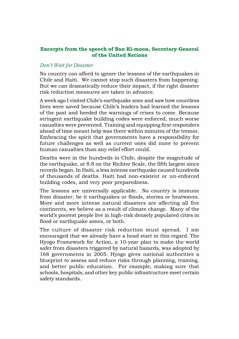
Excerpts from the speech of Ban Ki-moon, Secretary-Generalof the United Nations
Don’t Wait for Disaster
No country can afford to ignore the lessons of the earthquakes inChile and Haiti. We cannot stop such disasters from happening.But we can dramatically reduce their impact, if the right disasterrisk reduction measures are taken in advance.
A week ago I visited Chile’s earthquake zone and saw how countlesslives were saved because Chile’s leaders had learned the lessonsof the past and heeded the warnings of crises to come. Becausestringent earthquake building codes were enforced, much worsecasualties were prevented. Training and equipping first respondersahead of time meant help was there within minutes of the tremor.Embracing the spirit that governments have a responsibility forfuture challenges as well as current ones did more to preventhuman casualties than any relief effort could.
Deaths were in the hundreds in Chile, despite the magnitude ofthe earthquake, at 8.8 on the Richter Scale, the fifth largest sincerecords began. In Haiti, a less intense earthquake caused hundredsof thousands of deaths. Haiti had non-existent or un-enforcedbuilding codes, and very poor preparedness.
The lessons are universally applicable. No country is immunefrom disaster, be it earthquakes or floods, storms or heatwaves.More and more intense natural disasters are affecting all fivecontinents, we believe as a result of climate change. Many of theworld’s poorest people live in high-risk densely populated cities inflood or earthquake zones, or both.
The culture of disaster risk reduction must spread. I amencouraged that we already have a head start in this regard. TheHyogo Framework for Action, a 10-year plan to make the worldsafer from disasters triggered by natural hazards, was adopted by168 governments in 2005. Hyogo gives national authorities ablueprint to assess and reduce risks through planning, training,and better public education. For example, making sure thatschools, hospitals, and other key public infrastructure meet certainsafety standards.
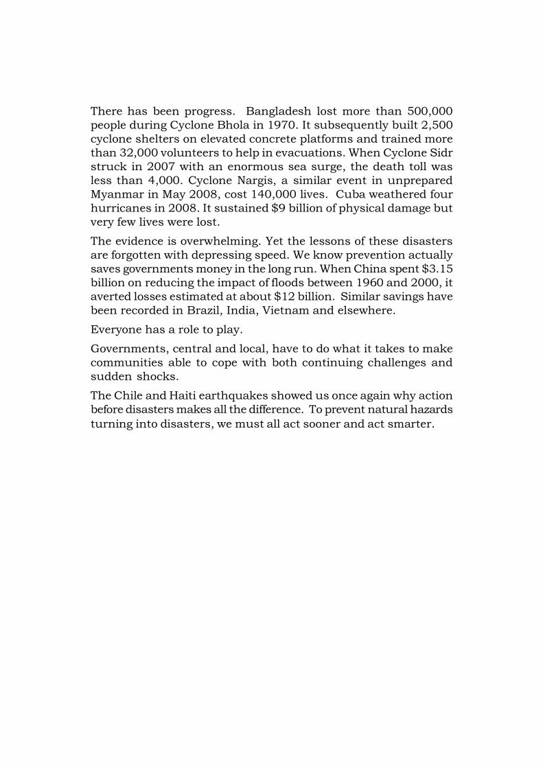
There has been progress. Bangladesh lost more than 500,000people during Cyclone Bhola in 1970. It subsequently built 2,500cyclone shelters on elevated concrete platforms and trained morethan 32,000 volunteers to help in evacuations. When Cyclone Sidrstruck in 2007 with an enormous sea surge, the death toll wasless than 4,000. Cyclone Nargis, a similar event in unpreparedMyanmar in May 2008, cost 140,000 lives. Cuba weathered fourhurricanes in 2008. It sustained $9 billion of physical damage butvery few lives were lost.
The evidence is overwhelming. Yet the lessons of these disastersare forgotten with depressing speed. We know prevention actuallysaves governments money in the long run. When China spent $3.15billion on reducing the impact of floods between 1960 and 2000, itaverted losses estimated at about $12 billion. Similar savings havebeen recorded in Brazil, India, Vietnam and elsewhere.
Everyone has a role to play.
Governments, central and local, have to do what it takes to makecommunities able to cope with both continuing challenges andsudden shocks.
The Chile and Haiti earthquakes showed us once again why actionbefore disasters makes all the difference. To prevent natural hazardsturning into disasters, we must all act sooner and act smarter.
Chapter 1 Introduction to Floods
1.1 What are floods?...……….…........................................................................1
1.2 Causes of floods….…………………………......................................................1
1.3 Types of floods.………………………………………………….……...…….........2
1.4 Flood impacts…………………………….………………..………………….........3
1.5 Destructive floods in Asia………..………………………………..……..…........4
Chapter 2 Floods in Myanmar
2.1 Geo-physical location of Myanmar…………...……………………………......6
2.2 Flood seasons and flood prone areas in Myanmar………………….…........7
2.3 Causes of flood in Myanmar………………………….………..………….........9
2.4 Major floods in Myanmar...……………………………………………….........11
Chapter 3 Flood Mitigation and Preparedness Measures
3.1 Flood Mitigation…………………………….……………………………......…...15
3.1.1 Structural flood mitigation measures………..…………………........15
a) Flood protection……………...……………………………….................15
b) Flood reduction…………...………………………………...............…...15
c) Flood diversion……………………..………………………...............…..16
d) Flood proofing…………………………..…………………................…..16
e) Engineered structures…………………………………...............……..19
f) Non-engineered structures……………………………..............……..19
3.1.2 Non-structural flood mitigation measures.………..…......………...20
a) Flood hazard map……………………….……………….….............…...20
b) Land use planning……………………………………….….............…...20
c) Building regulations and codes…………………………..............…..22
d) Flood forecasting and warning…………………………..….................24
Table of Contents
e) Training and education………………………………..…….............…26
f) Public awareness generation………………………….….............…..26
g) Community-based mitigation………….……………..….…............…27
3.2 Flood Preparedness at the Community Level……………………....………28
a) Community-based Organization on Disaster Risk Reduction........28
b) Community-based Disaster Management Plan (CBDMP)...........29
c) Community-based flood risk assessment…..…….……….............29
d) Flood forecasts and early warning dissemination….…….............30
e) Flood referencing…………………….………………………..….............31
f) Community safe shelter………….….…………………………............32
g) Evacuation arrangements………...……………………………............32
h) Trainings and capacity building…..………………………….............33
i) Drill…………………………………………………………………............34
3.3 Preparedness at Household Level……..……………………………………..35
Chapter 4 Flood Safety Tips
4.1 When warned of flood………………….…….………..…………………….......38
4.2 During a flood……………………………………………….……………….........38
4.3 If evacuation is advised……………………………………………………........40
4.4 After a flood……………………………………………….…………………...........41

1
1.1 What are floods?A flood is a high flow or overflow of water from a river or similarsource of water occurring over a period of time. Heavy rain spellcan result in an extra volume of water in the waterways, leading toa rise in the water level of streams and rivers. A flood happenswhen the carrying capacity of the waterways fails to hold the totalvolume of increased water at any given time.
Chapter 1
1.2 Causes of floodsThe main causes of floods are:
• Continuous heavy rain
• Bad drainage facilities
• Blocking of river channels by landslides
• Narrowness of the river
• Change in the course of river
• Inefficient engineering design in the construction of embankments,dams and canals
Introduction to Flood
Flood in Myit Nge, 2006@DMH@DMH
2
• Failure of hydraulic and other control measures
• Destruction of mangroves and trees which do not grow back
• Deforestation and removal of root system
• Sediment deposit or silting of the river bed
• Rapid urbanisation with no proper drainage facility
• Storm surge
• Tsunami
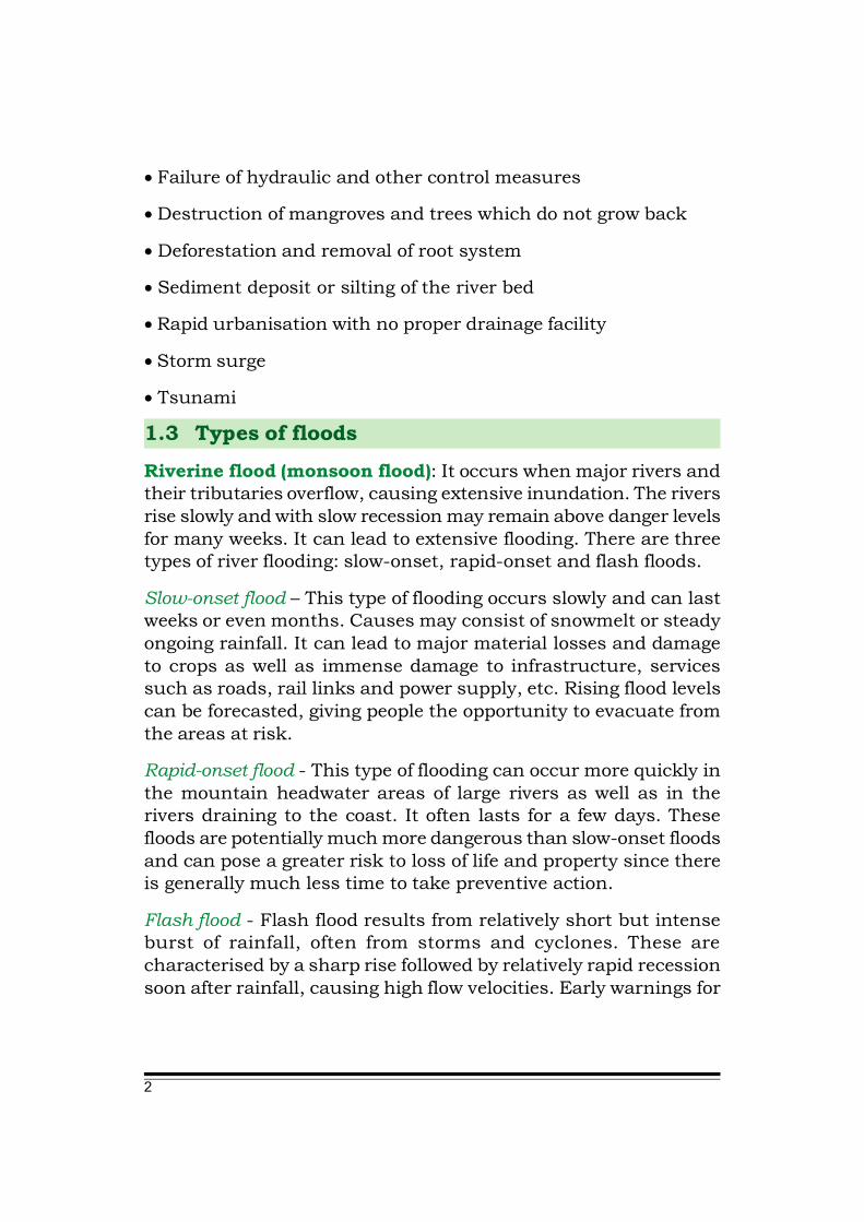
1.3 Types of floodsRiverine flood (monsoon flood): It occurs when major rivers andtheir tributaries overflow, causing extensive inundation. The riversrise slowly and with slow recession may remain above danger levelsfor many weeks. It can lead to extensive flooding. There are threetypes of river flooding: slow-onset, rapid-onset and flash floods.
Slow-onset flood – This type of flooding occurs slowly and can lastweeks or even months. Causes may consist of snowmelt or steadyongoing rainfall. It can lead to major material losses and damageto crops as well as immense damage to infrastructure, servicessuch as roads, rail links and power supply, etc. Rising flood levelscan be forecasted, giving people the opportunity to evacuate fromthe areas at risk.
Rapid-onset flood - This type of flooding can occur more quickly inthe mountain headwater areas of large rivers as well as in therivers draining to the coast. It often lasts for a few days. Thesefloods are potentially much more dangerous than slow-onset floodsand can pose a greater risk to loss of life and property since thereis generally much less time to take preventive action.
Flash flood - Flash flood results from relatively short but intenseburst of rainfall, often from storms and cyclones. These arecharacterised by a sharp rise followed by relatively rapid recessionsoon after rainfall, causing high flow velocities. Early warnings for

3
timely evacuation may not always be possible. This type of floodingposes the greatest threat to loss of life and can result in damagesto property and major social and economic disruption.
Coastal floods: Coastal floods occur when strong onshore windspush water from an ocean, bay or inlet onto land. This can takethe form of storm surges associated with tropical storms, cyclones,tsunami and tidal waves. It can cover vast areas along the coast.
Urban floods: This type of flood takes place in urban areas becauseof lack of proper drainage facilities.
1.4 Flood impactsPhysical infrastructure – Structures damaged or collapsed bywashing waters, landslide triggered on account of water becomingsaturated. Boats and fishing equipments may be lost or damagedin coastal areas.
Damaged Yangon-Mandalay highway due to flood@DMH
4
Casualties and impact on public health – people and livestockdeaths caused by drowning, very few serious injuries. Outbreak ofepidemics, diarrohea, viral infections, malaria and other waterrelated health hazards.
Water supplies – contamination of water (wells, ground water and,piped water supply).
Crops and food supplies – sudden food shortage may follow dueto loss of entire harvest, standing crop damage, spoiling of grainswhen saturated in water along with loss of animal fodder. The cropstorage facilities and godowns may get submerged resulting inimmediate food shortage. Floods may also affect the soilcharacteristics and its fertility.
The land may be rendered infertile due to erosion of top layer ormay turn saline if sea water inundates the area.
1.5 Destructive floods in Asia• The Hwang-ho River flood in 1887 claimed 3,000,000 lives in
China.
• The Yangtze (Chang Jiang) river floods of 1935 killed 145,000people.
• Flooding in Hanoi, Vietnam in 1971 killed 100,000 people.
• The failure of Banqiao Dam in China claimed 232,000 lives in1975.
• The Yellow River Flood of 1991 in China killed approximately2,000,000 people.
• 1998 Yangtze River floods left 14�million people homeless.
• Bangladesh was flooded in 1998, with numerous victims.
• Jakarta’s floods in January 2007 affected the whole city.80�people died.

5
• The floods in Peninsular Malaysia, Sabah and Sumatra inDecember 2006 and January 2007 are considered to be the worstin 100 years, resulting in the evacuation of over 100,000�peoplein the worst-hit state of Johor at its peak.
• Korea saw one of its worst floods in May 2006.
• Flooding in Mumbai (India) in July 2005 left over 700 dead. Someareas went under 5�m of water.
@DMH
Flood in Myit Nge, 2006
6
2.1 Geo-physical location of MyanmarThe topography of the country varies from hilly and mountainousareas in the west, north and east, a semi-arid dry zone in the centralregion, coastal areas in the west and alluvial plains in the southerndelta. The major river systems follow the lie of the mountain rangesfrom the north of the country to the south. There are four mainrivers crossing Myanmar: Ayeyarwady, Thanlwin, Chindwin andSittaung.
The Ayeyarwady River, about 1,550 km (960 miles) long, flows fromnorth to south. Its total drainage area is about 411,000 square km(158,700 square miles) and splits into many streams and drainsinto the Andaman Sea.
The Ayeyarwady Delta is a flat plain with the exception of lowwestern hills, and the extension of the Rakhine mountain range.The Chindwin River is the biggest tributary of the Ayeyarwady River.The river flows 840 kilometres miles from north to south to jointhe Ayeyarwady at a tributary near Mandalay. Sittaung River liesin central-east Myanmar, rising northeast of Yamethin on the edgeof the Shan Plateau and flowing south for 420 km (260 miles) toempty into the Gulf of Martaban of the Andaman Sea. The broadSittaung River valley lies between the Bago mountains on the westand the steep Shan Plateau on the east. The Thanlwin River, whichstarts in Tibet flows through Yunnan, Myanmar and Thailand onits way to its mounth in the Andaman Sea, near Mawlamyaing.
Besides the main rivers, Myanmar has many small and mediumrivers, streams and creeks flowing through every region of thecountry. Therefore, the topography of Myanmar comprisesmountains, highlands, an intricate river system, vast river basins,lowlands and the delta region. During the monsoon season when
Floods in Myanmar
Chapter 2
7
rainfall is rather heavy in the northern regions, the rivers fill totheir capacity, often exceeding maximum levels; this sometimescauses flooding disasters in the towns and villages alongside of therivers.
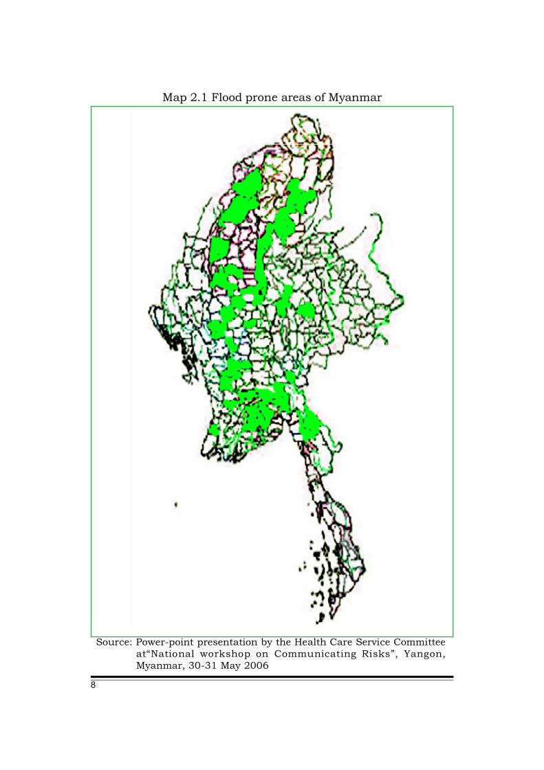
2.2 Flood seasons and flood prone areas in MyanmarFlooding has always been one of the major hazards in Myanmar,accounting for 11% of all disasters, second only to fire.
Floods are most common during the rainy season. Myanmar usuallyreceives all its rainfall between mid-May and October. The threatof flooding usually occurs in June, July, August and late Septemberto October with the highest risk in August around the period ofpeak monsoon rains.
In general, the following parts of the country are prone to differenttypes of flood:
The catchment areas of major rivers in the north and centralzone are prone to riverine floods. The Ayeyarwady River basin andthe catchment occupy 60% of the country area traversing Chin,Kachin and Shan States, Mandalay, Magwe, Bago, Yangon andAyeyarwady Divisions. Floods, in consequence, can occur over awide range of the region.
The Southern Delta faces riverine floods when there is a floodtide and high river water flow at the same time. In these areas, thelands are protected from floods by earthen dykes, but there havebeen times when floods have overpowered the dykes and causedthe loss of life.
The mountainous and hilly Kachin, Shan, Mon and Chin Stateareas are threatened by the danger of flash floods. In Kachin State,at the confluences of the Ayeyarwady River, the snow melts at higheraltitudes frequently and results in flash floods at the beginning ofsummer.
Along the coastal region in Rakhine State, floods occur as asecondary hazard generated by cyclones.
8
Map 2.1 Flood prone areas of Myanmar
Source: Power-point presentation by the Health Care Service Committeeat“National workshop on Communicating Risks”, Yangon,Myanmar, 30-31 May 2006

9
2.3 Causes of flood in MyanmarRiverine floods: These are the most common type of flood inMyanmar. They take place when the monsoon troughs or lowpressure waves superimpose on the general monsoon patternresulting in intense rainfall over significant strategic areas of theriver catchments.
In Ayeyarwady and Chindwin rivers, the flooding occurs whenintense rain persists for at least 3 days over the headwaters of therivers in northern Myanmar. Most of the flooding in the lowerAyeyarwady and the delta is occured by Chindwin, when its floodcoincides with upper Ayeyarwady floods.
In Sittaung and Thanlwinrivers, floods are duly causedby rainfall associated with lowpressure waves (the remnantsof typhoons and tropical stormsof South China Sea) movingfrom east to west across thecountry.
Flood in Pyay (1974)@DMH
Flood in Myitkyina, 2004
@DMH@DMH
Coastal floods: Tropical storms from the Bay of Bengal trigger stormsurges and cause floods along the Rakhine coastline during thepre- and post- monsoon period.

10
Urban and localised floods: In the cities and towns, localised floodsoccur from time to time. This is due to a combination of cloudburst,saturated soil, poor infiltration rates and inadequate or poorly builtinfrastructure (such as blocked drains). In the rural areas, breakageof water resistance structures, such as dams, dykes and leveesdestroy valuable farm lands.
Flash floods: Flash floods, frequent in the rivers, are caused bythe heavy rainfall striking at the head water region for a sustainedperiod of 1-3 days. In the central and delta regions in the southernpart of the country, river bank erosions accidents are frequentincidents.
Flood in Yangon, Nargis 2008
@UN-Habitat
Flood in Shwesettaw Pagoda (12 April,@DMH

11
2.4 Major floods in Myanmar(1) Flood Record in Myanmar (since 1966)
Source: DMH
12
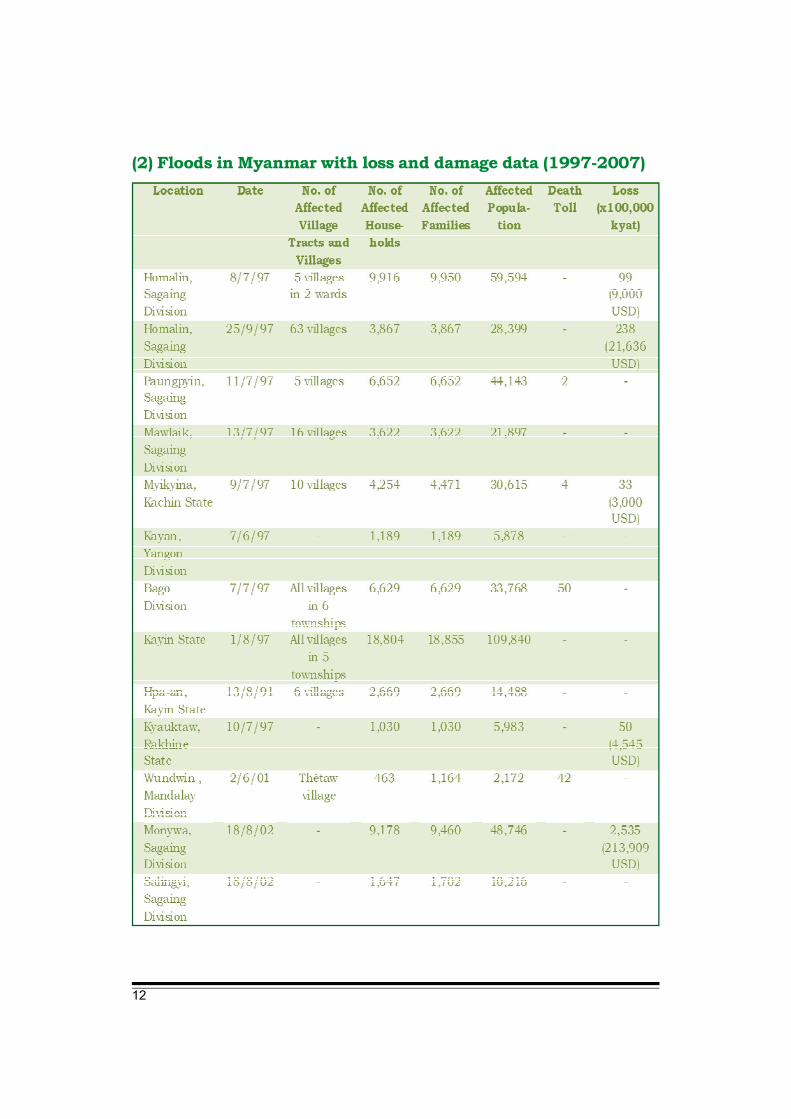
(2) Floods in Myanmar with loss and damage data (1997-2007)

13
Source: Hazard Profile of Myanmar

14
In the past two decades, the duration of monsoon in Myanmar isgetting shorter but much more intense and the country hasexperienced heavier rainfall. For instance, in 2008, the annualrainfall surpassed yearly averages amount significantly in Kachin,upper Sagaing, Mon, Yangon, Ayeyarwady, Kayah, Kayin,Tanintharyi, Bago and Rakhine. Accordingly, the country is likelyto suffer more severe floodings in the future. Unless effectivemitigation and preparedness measures are adopted, floods willgive serious negative repercussions, including loss of life anddamage to property, critical infrastructure, crops and livestock.Thus, the potential harm to the economy and social fabric of thecountry as a whole could be catastrophic.
Flood Mitigation and Preparedness Measures
Figure 3.1 Annual durations of southwest monson season in Myanmar(1956-2000)
Source: DMH
Chapter 3
15
3.1 Flood MitigationThe term flood mitigation refers to long-term sustainable measuresthat can be taken up to reduce the impact of flood hazards. Thesemeasures can be structural and non-structural. The structuralmeasures refer to construction and management of dykes, dams,reservoirs, irrigation system, raised settlements, housing designand other physical measures, etc. The non-structural measuresinclude training, planning, awareness raising, change in theagricultural production patterns, flood resistant cropping, etc.These measures need government intervention and support withcommunity participation. Some of the measures, especiallylegislation and policy frameworks, cannot be initiated by thecommunity itself and it requires the government’s initiative andintervention.
3.1.1 Structural flood mitigation measures
Structural flood mitigation measures include the following:
a) Flood protection
Flood protection is a major long-term structural system thatphysically prevents some (or all) flood water from entering adesignated area. Flood protection does not necessarily meancomplete protection from floods, but it can contribute to controlflooding and drainage. Flood protection measures involvestrengthening of embankments, construction and reinforcementof dykes and construction of by-pass channels to improve the flowof water in drainage channels. An essential component of floodprotection is continuity of operation and maintenance of thefacilities constructed.
b) Flood reduction
Projects such as reforestation, protection of vegetation, clearing ofdebris from streams and other water holding areas, andconservation of ponds and lakes may help to reduce flooding bydecreasing the total water runoff. In some areas, absorption couldbe a valuable mitigation strategy.
16
c) Flood diversion
Flood diversion includes levees, embankments, dams and channelaugmentation. Embankments along the rivers, and sea walls alongthe coasts may keep water away from the flood plains. Dams canstore water and can release water at a manageable rate. However,failure to manage water release in earthquakes may cause floodsin the lower areas.
d) Flood proofing
Flood proofing reduces the risk of damage. Flood proofing measurescan be applied to public structures such as schools, hospitals andhealth care centres, pagodas, temples, and other infrastructureincluding individual houses as they are often used as temporaryshelter during floods. Flood proofing techniques can be undertakenby individual property owners without waiting for governmentaction.
Flood proofing can be undertaken through the following measures:
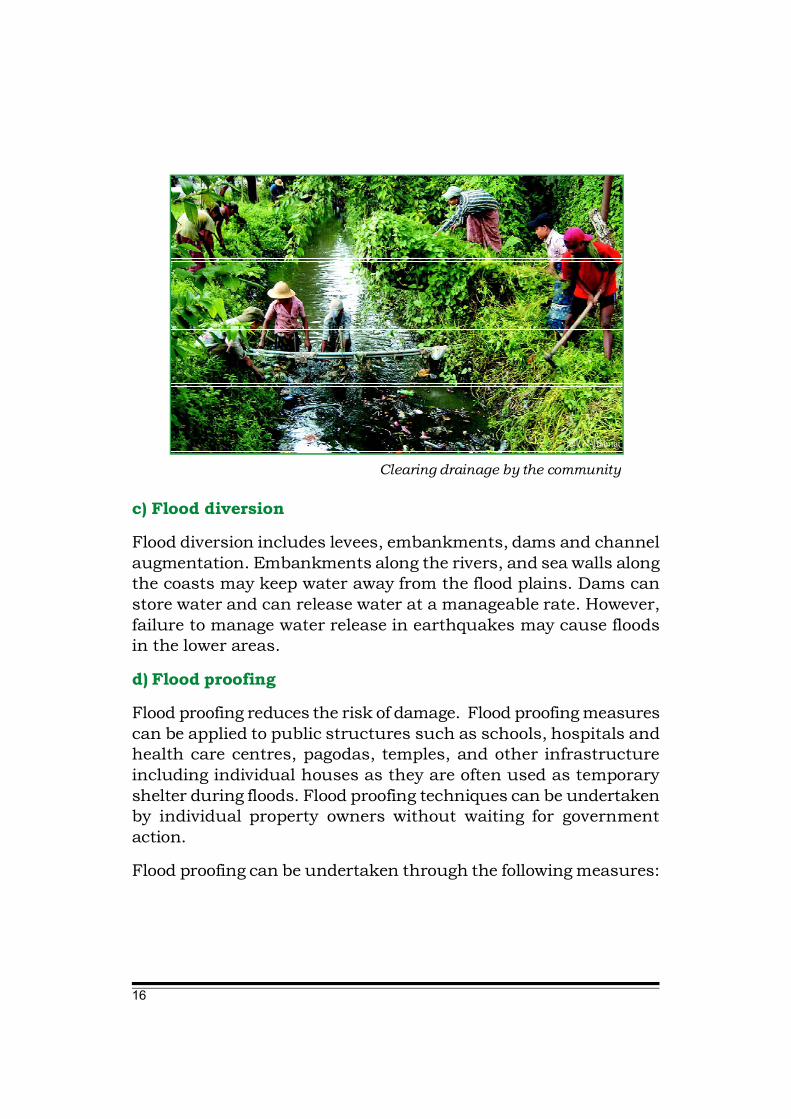
Clearing drainage by the community
@UN-Habitat

17
• Permanent measures are designated to provide long-lastingprotection against flooding and do not depend upon any floodforecast or action to put them into effect.
• Contingent measures rely upon receipt of a warning or forecast:action is required to make the protection operational.
• Emergency measures may either be improvised in an emergencyor carried out according to prior emergency plans of action.
At the community level, several approaches to flood proofing ofbuildings or individual units may be implemented, summarisedas follows.
1. Elevating the building: valuable property is kept out of reach offloodwater levels and structural damage is avoided. The buildingor individual unit can be elevated on land fill, posts, piles orextended walls. Special attention must be given to the design ofthe foundations to avoid settlement or tilting of the building.
@UNDP
A monastry elevated on posts, piles above flood levelso that the community can use it as a shelter during a flood.
18
2. Constructing barriers - between the building and floodwater. Someof the damage due to flooding can be minimised by appropriatemeasures to prevent flood water. Barriers (levee or reinforced floodwalls) can be constructed around the entire building, or on theside of the building exposed to possible floods, in order to preventflood water damage to the structure. Barriers can be made fromearth, concrete masonry or steel. Care must be taken to ensurethey are watertight. In this method, all areas below the floodprotection level are made watertight. Walls are coated with awaterproofing compound or plastic sheeting and openings, suchas doors, windows, sewer lines and vents, are closed temporarily,with sandbags or removable closures or shutters to secure thebuilding against water flows. Such protection methods should beaccompanied by adequate drainage to carry the water away fromthe building.
3. Dry Flood proofing or sealing: This method consists of makingthe building walls and floor watertight so that water cannot enter.The method can only be used in areas of shallow flooding tocompletely seal a building against water, i.e., in areas where floodlevels do not exceed one metre and flood velocity is minimal.Sandbagging also represents temporary protection which can beutilised to close an opening or to protect a vulnerable part of thestructure.
4. Protection of other facilities:
• Temporary removal of goods: In some areas, temporary removalof goods, equipment and supplies in the case of emergency canresult in substantial reduction of damages.
• Watertight storage facilities: Storage tanks in flood-prone areasfitted with watertight caps can prevent goods and equipment fromflood damage.
• Proper anchorage: During floods, some materials and buoyantstructures (e.g., lumber) can be carried away by flood water,resulting not only in their loss but also in possible destruction

19
and debris accumulation downstream. Anchoring such structurescould reduce damage.
• Utilities service: Utility systems like water supply and waterdistribution systems should be checked for leakages and repairedregularly to prevent contamination by seepage of flood water.
e) Engineered structures
Construction of engineered structures in the flood plains andstrengthening of structures to withstand flood forces and seepage.The buildings should be constructed on an elevated area. Ifnecessary, build on stilts or a platform. Engineered structuresinvolve architects and engineers during the planning, designingand construction phases. They may include buildings ranging inscale, from simple dwellings to multi-storey office blocks, as wellas infrastructure such as electricity pylons, dams, embankments,ports, roads, railways and bridges. While professionals are trainedto plan, design and supervise the construction of buildings andinfrastructure to achieve necessary structural safety standards,they may need additional training to incorporate mitigationpractices that may withstand various disasters into their structuraldesigns.
f) Non-engineered structures
Non-engineered structures are those constructed by their ownersthemselves or by local carpenters and masons who generally lackformal training. Such structures largely comprise simple dwellingsand public buildings, built with local materials in the traditionalmanner. In some disasters, high casualties and economic lossescan be attributed to the failure of non-engineered structures.Another important aspect of increasing the safety of non-engineeredstructures is to avoid building on hazardous sites such as steepslopes subject to landslides, floodplains subject to flash floods orriver bank erosion, or coastal areas exposed to storm surges.However, people often do not want to leave their traditional homesand the area in which they have been living for generations, even
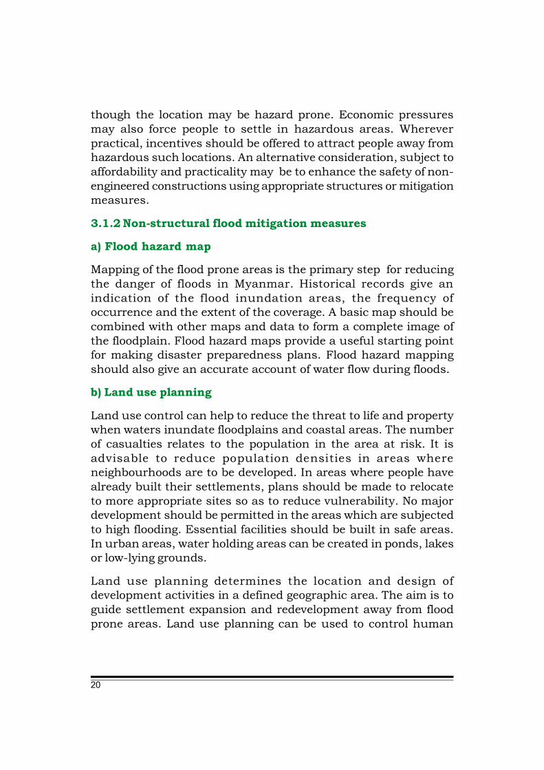
20
though the location may be hazard prone. Economic pressuresmay also force people to settle in hazardous areas. Whereverpractical, incentives should be offered to attract people away fromhazardous such locations. An alternative consideration, subject toaffordability and practicality may be to enhance the safety of non-engineered constructions using appropriate structures or mitigationmeasures.
3.1.2 Non-structural flood mitigation measures
a) Flood hazard map
Mapping of the flood prone areas is the primary step for reducingthe danger of floods in Myanmar. Historical records give anindication of the flood inundation areas, the frequency ofoccurrence and the extent of the coverage. A basic map should becombined with other maps and data to form a complete image ofthe floodplain. Flood hazard maps provide a useful starting pointfor making disaster preparedness plans. Flood hazard mappingshould also give an accurate account of water flow during floods.
b) Land use planning
Land use control can help to reduce the threat to life and propertywhen waters inundate floodplains and coastal areas. The numberof casualties relates to the population in the area at risk. It isadvisable to reduce population densities in areas whereneighbourhoods are to be developed. In areas where people havealready built their settlements, plans should be made to relocateto more appropriate sites so as to reduce vulnerability. No majordevelopment should be permitted in the areas which are subjectedto high flooding. Essential facilities should be built in safe areas.In urban areas, water holding areas can be created in ponds, lakesor low-lying grounds.
Land use planning determines the location and design ofdevelopment activities in a defined geographic area. The aim is toguide settlement expansion and redevelopment away from floodprone areas. Land use planning can be used to control human
21
development on the floodplain, which in turn, aims to reduce thevulnerability of its inhabitants to flooding.
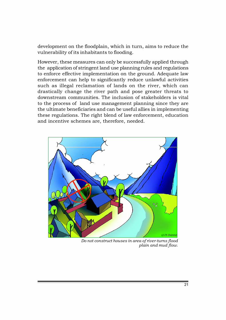
However, these measures can only be successfully applied throughthe application of stringent land use planning rules and regulationsto enforce effective implementation on the ground. Adequate lawenforcement can help to significantly reduce unlawful activitiessuch as illegal reclamation of lands on the river, which candrastically change the river path and pose greater threats todownstream communities. The inclusion of stakeholders is vitalto the process of land use management planning since they arethe ultimate beneficiaries and can be useful allies in implementingthese regulations. The right blend of law enforcement, educationand incentive schemes are, therefore, needed.
Do not construct houses in area of river-turns floodplain and mud flow.
@UN-Habitat

22
c) Building regulations and codes
Building regulations and codes provide general guidelines forappropriate design methodologies and construction techniques.Building codes which specify design and construction requirementsfor disaster-resistant structures should be formulated and enforced.
Some suggestions for flood resistant building designs are providedbelow.
Location
• Avoid natural drainage paths, water courses, water detentionareas and restricted reservation areas.
• Construct the buildings on the best bearing soil on ground higherthan the Probable Maximum Flood (PMF) level.
• If locating the building on high ground is not possible, constructthe building on individual high mounds with thoroughlycompacted soil surrounded by trees to maintain stability.
House construction above the High Flood Level (HFL)
@UN-Habitat

23
Foundations and Plinths
• Foundations should be deep enough (should be at least between1 to 2 metres) to prevent undermining The plinth should be abovethe level of the HFL or PMF.
• Buildings may be raised on strong columns (stilts or piles).
• When it is not possible to raise the whole building, raise the floorof at least one room to use as a flood shelter.
Configuration (building shape)
• The building shape that will be reducing the impact of the wateris circular.
• The V shape facing the oncoming water is advisable. It is best tohave as little surface as possible facing the oncoming water.
Structure
• Use strong corner posts fixed into deep foundations (reinforcedconcrete where possible).
• If using timber pillars, the free height should not be more than2250mm and they should be anchored in the ground at least600mm deep.
• Houses raised on stilts should have a rigid frame and be bracedagainst overturning.
• All joints should be tied with metal or wire strips. They should bebraced diagonally using fixed wires or wooden strips.
Walls and openings
• If thatch is used as wall cladding, they should be in two parts,upper and lower so the bottom part can be removed to allow thefree flow of water through the building.
• If fixed materials are used such as bricks or mud blocks, thendoors and windows should be positioned to allow the water toflow through.
24
Roof
• The height of the roof should be well above the height of theflood.
• The roof should have a flat section and should be strong enoughto hold the weight of the occupants of the house during a floodemergency.
d) Flood forecasting and warning
With exception of flash floods, most floods allow for a reasonablewarning period. Heavy precipitation will give sufficient warning ofthe possibility of river flooding. High tides with high winds mayindicate flooding in the coastal areas. Evacuation is possible withsuitable monitoring and warning.
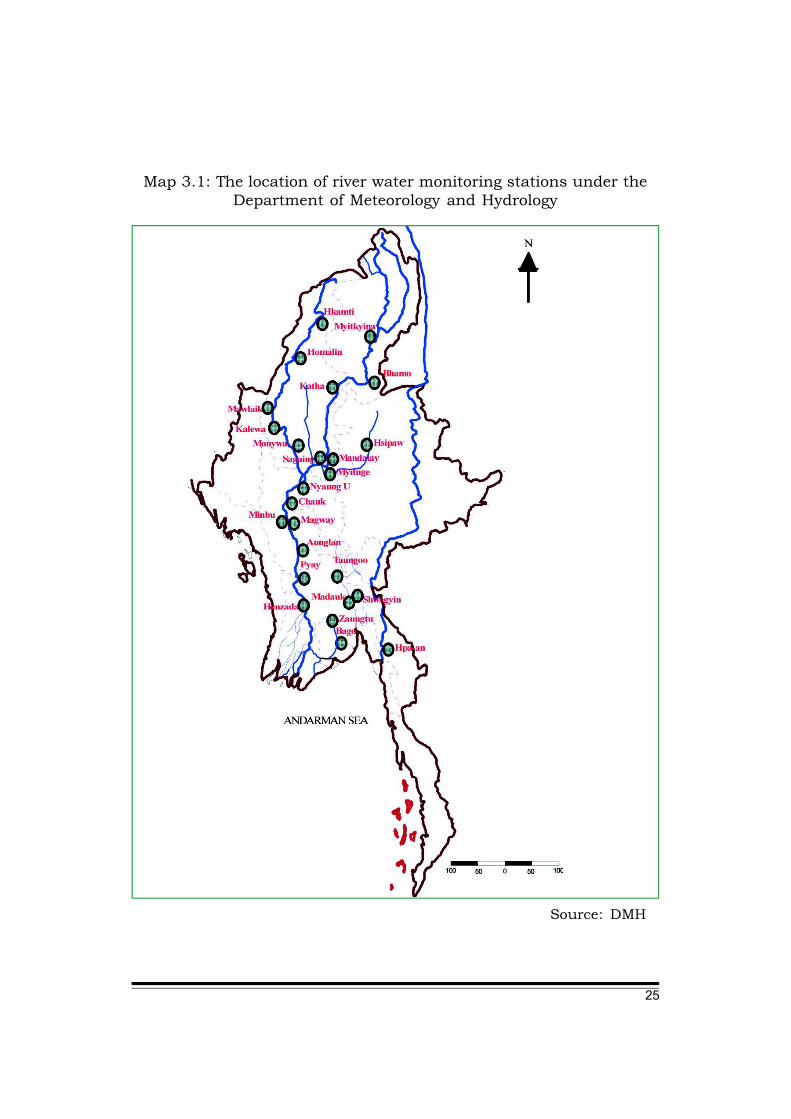
In Myanmar, at the national level, the Department of Meteorologyand Hydrology (DMH) is largely responsible for flood monitoring,weather forecasting and issuance of early warning. The HydrologyDivision of the Department of Meteorology and Hydrology has riverwater monitoring stations located along the major rivers ofMyanmar: Ayeyarwady, Chindwin, Duhtawady, Sittaung, Bago,Thanlwin and Shwe Kyin. A river flood warning is issued when theriver waters reach about 1 meter below the danger level. Riverflood warnings give at least 24 to 72 hours of advance notice. Thewarnings are also disseminated through different channels ofcommunication such as radio, television, newspaper, telegraphand telephone to the administrative authorities of the flood prone
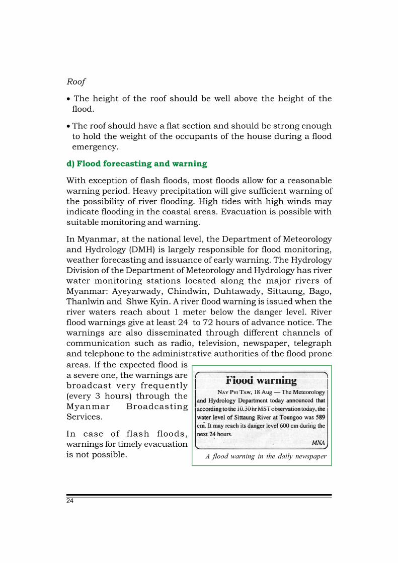
A flood warning in the daily newspaper
areas. If the expected flood isa severe one, the warnings arebroadcast very frequently(every 3 hours) through theMyanmar BroadcastingServices.
In case of flash floods,warnings for timely evacuationis not possible.
25
Map 3.1: The location of river water monitoring stations under theDepartment of Meteorology and Hydrology
Source: DMH
26
e) Training and education
Training programs and public education are necessary to ensurethat mitigation programs would be supported and properlyimplemented. Specialised trainings should be organised for localleaders, volunteers, youths etc. who are likely to play an importantrole in search and rescue operations. Such trainings should bean annual feature and should take place about two months inadvance of the flood season. In the training courses, specificsubjects like health, sanitation and management of relief campsshould be included.
f) Public awareness generation
Public awareness generation is a process through which peopleliving in flood-prone areas are sensitised regarding specific dangersof flooding. It includes educating, informing and warning thecommunity about floods and helping them to be better preparedfor response to flood emergency situations, with less minimumdependence on outside assistance or external intervention.
Through appropriate actions, this increased resilience can helpprevent loss of human life and property. The objectives of publicawareness generation on floods are to:
• Increase public knowledge on floods, their nature and possibleconsequences and impacts.
• Improve public knowledge on practical preparedness measuresat the household level that the communities can implement ontheir own.
• Inform the public about flood early warning systems and variousmeans of communication to receive warning signals and floodinformation.
• Disseminate information on flood preparedness programs andmobilise support for coordinated flood response activities withinlocal authorities or township disaster management committeesand community-based disaster management organisations.

27
The following are some of the mediums that can be used forconducting awareness raising campaigns:
• Electronic media - radio, TV, video spots, photo packages, audiotapes or cassettes.
• Print media - newspapers, leaflets, brochures, booklets, postersand billboards.
• Community activities - meetings, community discussions andconsultations.
• Community oriented programs such as street plays, distributionof pamphlets, door-to-door campaigns and school programs.
g) Community-based mitigation
The following activities are suggested for effective flood mitigationmeasures which can be implemented through the community’sstrength and capacity.
• Sedimentation clearance
• Reforestation programme
• Dike and flood wall construction
• Flood fighting: organising teams to repair embankments, pilesandbags and stockpile needed materials
• Applying flood compatible farming practices. Special varieties ofseeds are available which can be harvested during the floodseason.
• Retrofitting: houses need to be made flood resistant
• Construction of multipurpose shelters
• Raising embankments can give shelter to the community as wellas the livestock during the time of floods.
28
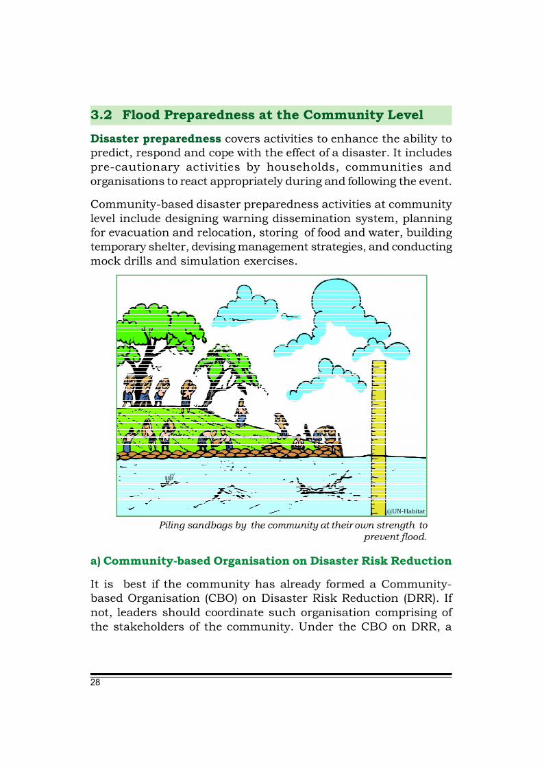
3.2 Flood Preparedness at the Community LevelDisaster preparedness covers activities to enhance the ability topredict, respond and cope with the effect of a disaster. It includespre-cautionary activities by households, communities andorganisations to react appropriately during and following the event.
Community-based disaster preparedness activities at communitylevel include designing warning dissemination system, planningfor evacuation and relocation, storing of food and water, buildingtemporary shelter, devising management strategies, and conductingmock drills and simulation exercises.
Piling sandbags by the community at their own strength toprevent flood.
@UN-Habitat
a) Community-based Organisation on Disaster Risk Reduction
It is best if the community has already formed a Community-based Organisation (CBO) on Disaster Risk Reduction (DRR). Ifnot, leaders should coordinate such organisation comprising ofthe stakeholders of the community. Under the CBO on DRR, a

29
number of sub-groups or teams should also be organised toaddress different disaster management activities such as earlywarning dissemination, evacuation, search and rescue, first aid,relief operation etc.
b) Community-based Disaster Management Plan (CBDMP)
The CBO should prepare a CBDMP with the help of localauthorities, NGOs, community leaders and the inclusion ofcommunity members. The plan should list activities which thecommunity members are required to perform for floodpreparedness. It should also detail out the delegation of duties sothat each individual is aware of his/her specific responsibilitieswhen an emergency warning is received. Once the plan is prepared,it should be shared with the community through various means,such as announcements in the community assembly and postingson the notice board of village or ward’s Peace and DevelopmentCouncil, monasteries/churches, markets, etc. Everyone in thecommunity should well understand the contents of the plan.Development and refinement of the plan should be ongoing; itshould be rehearsed through the use of drills and evaluated for itseffectiveness when disaster strikes the community. It should beupdated periodically or regularly at predetermined intervals sothat it will reflect and adapt the changing conditions of thecommunity, climate, and natural environment.
c) Community-based flood risk assessment
The community-based flood risk assessment is needed to ensurethat all community members living in flood prone areas understandthe dangers properly. They should know the flood history of thearea and understand the flood warning messages, the impacts offlooding, and the areas vulnerable to different degrees of flooding.The CBO on DRR should also prepare and discuss the details oflocal flood hazard map, with the involvement of other communitymembers. The map should also indicate the flood path and possiblesequences of flooding in the area in advance.

30
d) Flood forecasts and early warning dissemination
Flood forecasts and warning are essential for relocation of peopleto safer areas and deployment of resources for flood responseactivities. A flood early warning system can facilitate thedissemination of vital information in a flood event, including whenand where the flood will occur, so that the decisions to takeprotective action are made on time and in accordance with thelevel of risk the warning conveys. A simple and effective earlywarning system is made of four main components, as follows:
• Flood hazard detection and forecasting
• Formulation of warning messages
• Dissemination of warning messages
• Community response.
The community working together to develop a community-baseddisaster management plan
@ Action Aid
31
People living in flood-prone areas should have a clear and sufficientknowledge of the risks they face and the existing early warningsystem.
It is also important to ensure that the relayed flood forecastsoriginate from a reliable and authorised source, for validationpurposes. The warning information, generated from the forecasts,should be despatched to the relevant local disaster managementagencies, which can then make decisions and initiate necessaryactions.
If a community is subject to flash floods, preparedness activitiessuch as organising volunteer groups, planning for flood levelmonitoring, discussion on information dissemination should beundertaken in advance.
e) Flood referencing
Flood referencing is an activity that can be carried out at thecommunity level, to forecast flooding by community members. It ismost useful for communities living along canals, tributaries, orsmall rivers, connected to major flood-prone rivers, but not coveredunder the national forecasting network. It involves the followingactivities:
• Installation of water level marker (or level gauge) along the riveror tributaries next to the village/community.
• Putting up of billboards placed at strategic points such as themarket place, junctions of main streets (where many people canview them).
• Training of selected focal persons within the community onmaintenance of the equipment being installed.
• Establishment of a proper communication system which canreceive flood information (forecasts and warnings) from thenational level and send real time information from the local levelto assist the weather stations of the Department of Meteorologyand Hydrology to produce flood forecast for the locality.

32
f) Community safe shelter
The community should identify flood shelters based on theiraccessibility, location, facility and capacity, etc. The safestevacuation routes and road-plans for relocation/evacuation shouldinclude designated flood shelters. All community members shouldbe well aware of the shelter. The following activities arerecommended to be included in the preparation of a safe shelter.
(a) cleaning/clearing the premises in and around the shelter,
(b) preparation of large-size cooking stoves,
(c) sinking a fresh or elevating the existing tube-well above flooddanger level,
(d) provision of smaller rooms/chambers for health care check-ups, lactating mothers and their children, privacy of adolescentgirls, and storage of medicine, food items, fuel-wood/ biomass/kerosene, and lanterns for lighting,
(e) identification of alternative shelters, and
(f) expansion of the capacity of shelters to prepare for the worst.
g) Evacuation arrangements
Evacuation plans should be prepared well in advance by therelevant local government agencies and NGOs, together with thecommunity volunteer groups. Each member/team of thecommunity must be given specific instructions and responsibilitiesin case of evacuation. In order to facilitate evacuation planning,the vulnerable areas should be clearly identified by using floodrisk mapping. Again, an evacuation centre (shelter) should beprepared and maintained. The community members should alsobe familiar with which routes they have to follow to reach theirdestination. In preparation of evacuation plans, more than onealternative evacuation route to a safe shelter should be identifiedso that lead time during evacuation can be minimized.
33
The following considerations will be useful in planning evacuationroutes to safe areas:
• Identification of the safest and shortest possible route to safearea (including alternate routes in case of unforeseen routeblockages) avoiding possible high current or water logged areasof unknown depth.
• Installation of signs or markings along the route for easyrecognition.
• Informing the public about the location of safe areas and theiraccess routes.
• Preparation of boats and other means of transport. It is crucial toperiodically check the working conditions of such equipment.
• As and when appropriate, it is advisable to relocate the mostvulnerable households closer to safe areas in advance.
h) Trainings and capacity building
Training is important to enhance the capability of the community-based organisation and its members to reduce disaster risks. Theaim of training is to enable the community-based organisation andother community members to understand the DRR activities ontheir own.
The training should be provided to: i) the members of thecommunity organisation, ii) members of the community at large,iii) special technical experts; e.g. masons, paramedics, teachers,farmers, and staff of the local authorities.
The training can cover following range of broad topics.
1. Disaster Risk Reduction Training
2. Emergency Response Training including Search and Rescue,Medical first aid, Relief coordination, distribution, Emergencyshelter management, evacuation management, etc.
34
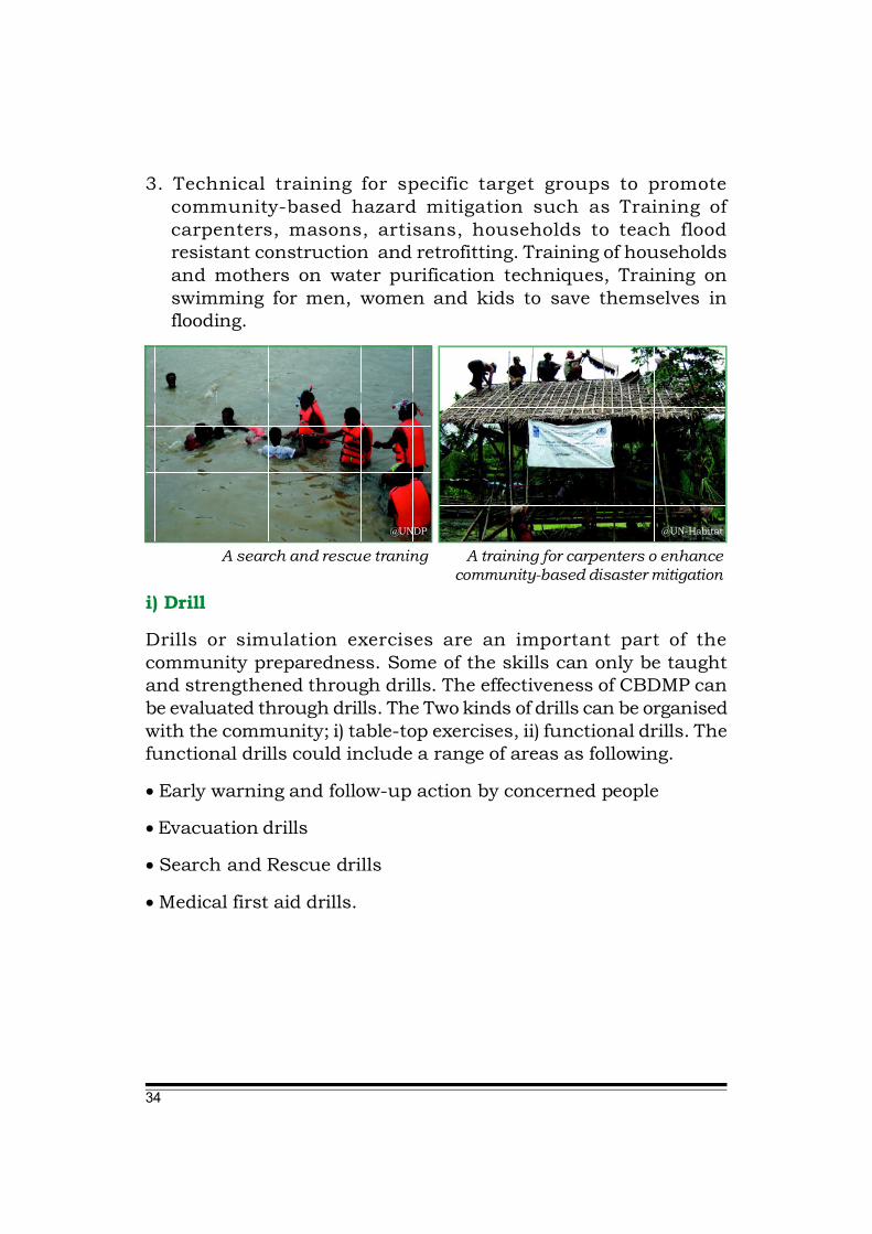
3. Technical training for specific target groups to promotecommunity-based hazard mitigation such as Training ofcarpenters, masons, artisans, households to teach floodresistant construction and retrofitting. Training of householdsand mothers on water purification techniques, Training onswimming for men, women and kids to save themselves inflooding.
@UNDP
A search and rescue traning
@UN-Habitat
A training for carpenters o enhancecommunity-based disaster mitigation
i) Drill
Drills or simulation exercises are an important part of thecommunity preparedness. Some of the skills can only be taughtand strengthened through drills. The effectiveness of CBDMP canbe evaluated through drills. The Two kinds of drills can be organisedwith the community; i) table-top exercises, ii) functional drills. Thefunctional drills could include a range of areas as following.
• Early warning and follow-up action by concerned people
• Evacuation drills
• Search and Rescue drills
• Medical first aid drills.
35
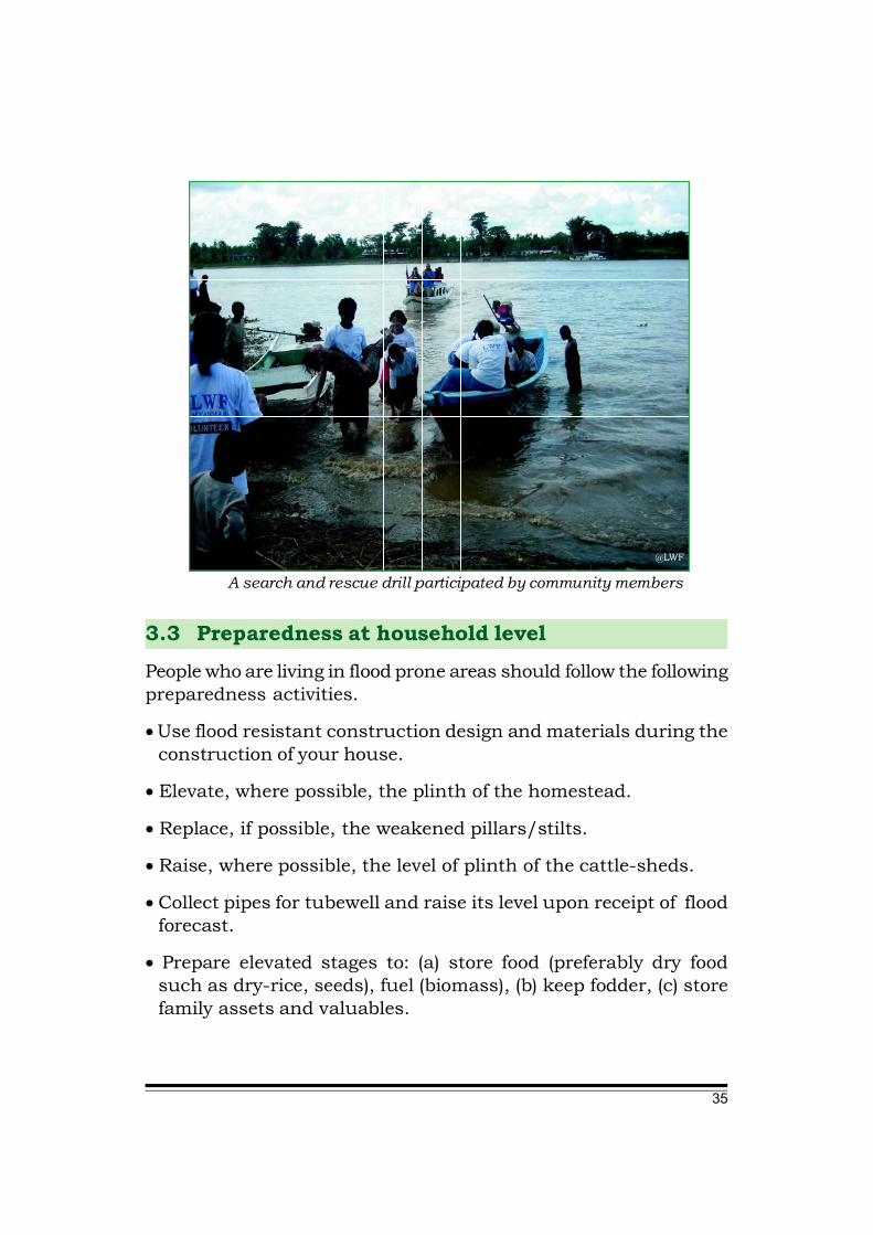
@LWF
A search and rescue drill participated by community members
3.3 Preparedness at household levelPeople who are living in flood prone areas should follow the followingpreparedness activities.
• Use flood resistant construction design and materials during theconstruction of your house.
• Elevate, where possible, the plinth of the homestead.
• Replace, if possible, the weakened pillars/stilts.
• Raise, where possible, the level of plinth of the cattle-sheds.
• Collect pipes for tubewell and raise its level upon receipt of floodforecast.
• Prepare elevated stages to: (a) store food (preferably dry foodsuch as dry-rice, seeds), fuel (biomass), (b) keep fodder, (c) storefamily assets and valuables.
36
• Stop cutting trees. Plant bamboo or appropriate trees aroundthe houses to prevent erosion.
• Do not throw trash in rivers or canals.
• Do not throw anything like cigarette butts or wrappers especiallythose made of plastic or non-biodegradable objects - around thecompound. Throw them away in identified designated places.These articles may clog or block the drainage system therebyimpeding the flow of water.
• Grow crops that can withstand flood or would suffer less damage.
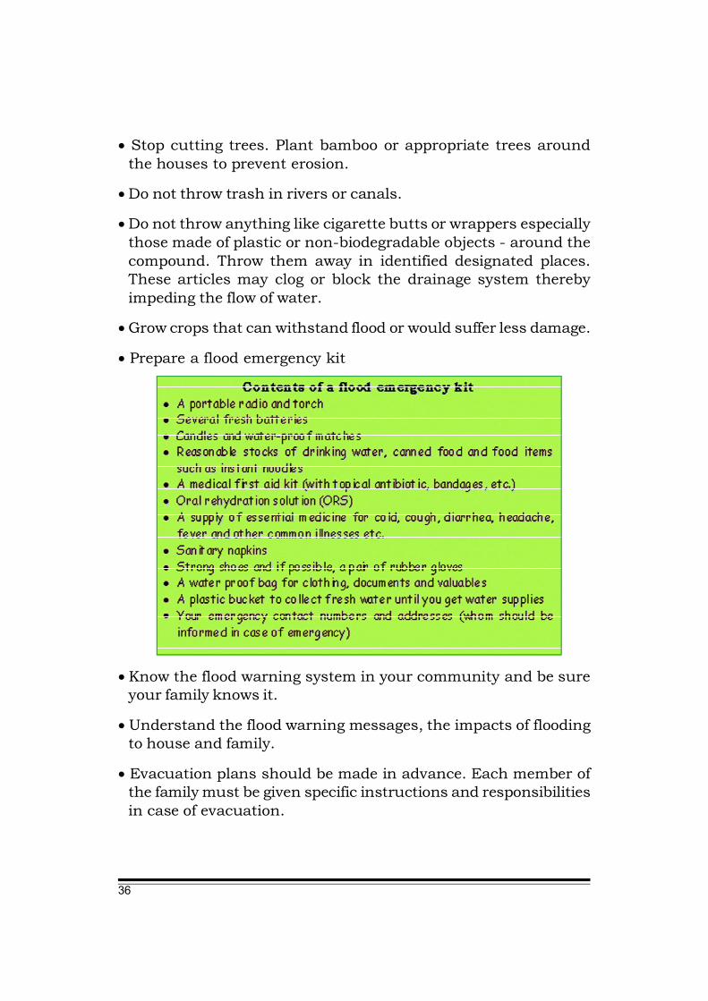
• Prepare a flood emergency kit
• Know the flood warning system in your community and be sureyour family knows it.
• Understand the flood warning messages, the impacts of floodingto house and family.
• Evacuation plans should be made in advance. Each member ofthe family must be given specific instructions and responsibilitiesin case of evacuation.

37
• Designate an evacuation area for the family and livestock.
• If a family has boats, make sure that they are well maintainedand securely tied to a tree or other permanent structure.
• Store essential food supplies and documents in a safer place.
• Raise the level of sanitary latrine. If possible, connect the latrineto the raised house by a bridge.
• Keep a few sachets/packets of ORS, sugar & salt, water purifyingtablets, emergency first aid material etc. in a basket hanging fromthe ceiling/roof.
• Collect several stems of banana plant and build raft(s).
• Inspect escape routes, houses, etc. for weaknesses before floods.If any weaknesses are found, reinforce the escape route bybuilding wall of sand bags to block the floodwaters.
• In times of adverse weather conditions, always listen to the officialwarnings issued by local authorities and news reports on thelocal radio or television.

38
4.1 When warned of flood
• Watch for rapid rising flood water.
• Listen to your radio for emergency instructions.
• Store drinking water in containers.
• Move household belongings to upper levels.
• Keep a stock of food which requires little cooking.
• Get livestock to a higher ground.
• If you find it is necessary to evacuate, move to a safe area beforeaccess is cut off by flood waters.
4.2 During a flood
• Keep the emergency kit safe and dry.
• Do not eat food which has been in contact with flood water. Donot eat spoiled food supplied by outsiders. Such food may containbacteria and could cause infection or illness. Do not eat deadanimals; they may have died due to diseases.
• Collect rain water until fresh water supplies are available. Boilall water before drinking it.
• Do not use water from dug wells during flooding.
• Do not use gas, electricity or other electrical appliances untilthey have been checked for safety.
• Do not allow children to play or swim in flood water.
• Beware of poisonous animals such as snakes, spiders which maymove to drier areas in your premises.
Flood Safety Tips
Chapter 4
39
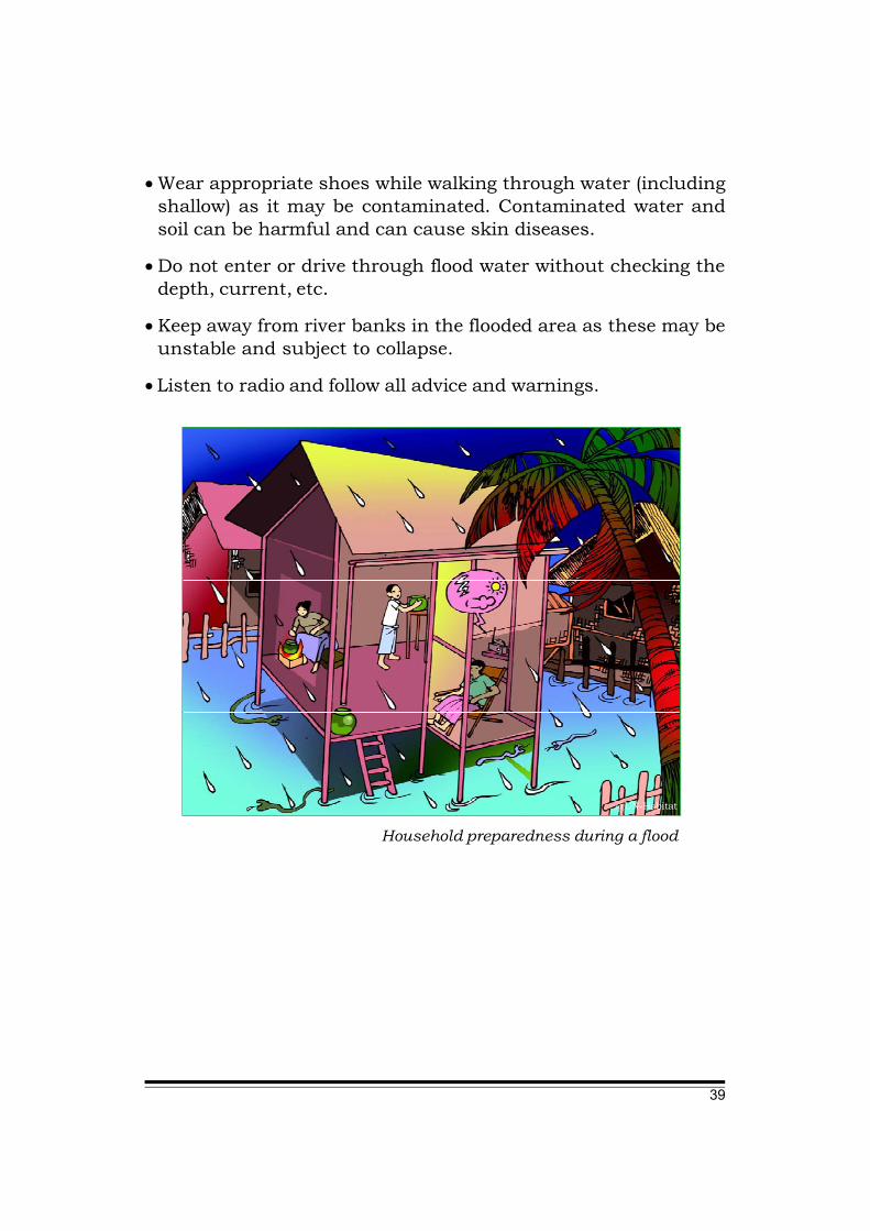
• Wear appropriate shoes while walking through water (includingshallow) as it may be contaminated. Contaminated water andsoil can be harmful and can cause skin diseases.
• Do not enter or drive through flood water without checking thedepth, current, etc.
• Keep away from river banks in the flooded area as these may beunstable and subject to collapse.
• Listen to radio and follow all advice and warnings.
Household preparedness during a flood
@UN-Habitat

40
4.3 If evacuation is advised
When advised to evacuate by local authorities or CBO on DRR or ifyou decide to leave the area, the following actions should be taken:
• Inform the responsible persons and neighbours and provide themall the details of the place you are going to.
• Collect all valuables, important certificates and documents etc.
• Stack furniture, electrical appliances and possessions away fromthe potential flood level.
• Turn off electricity, gas supply and water and close the windowsand doors of the house.
• Take the emergency kit.
• Lock the doors of the house before leaving.
• Be sure to follow the recommended evacuation routes.
Evacuation to safe places
@UN-Habitat

41
4.4 After a flood
Although the floodwater levels may be decreased, many dangersmay still exist in the house and compound. The following actionsare suggested for safety:
• Inform the responsible person in the community and neighboursabout your return to home and seek advice before making adecision to enter.
• On way back home, if you find roads with stop signs, please avoidthat road and find alternate route.
• Continue listening to the radio for news. Additional flooding orflash floods may occur.
• Avoid walking through the flooded area. Flooded water oftenerodes roads and walkways. Flooding may have caused changesto your familiar roads and paths. Flood debris may hide poisonousanimals (like snake and spiders) broken bottles and sharp steelends.
Do not walk through flooded water. Standing water may beelectrically charged from underground or downed power lines.
@UN-Habitat
42
• If you need to walk through a flooded area, use the firm groundto walk on. Standing water may be electrically charged fromunderground or downed power lines.
• Use mosquito-nets when you sleep.
• Do not go near river banks or where there are signs of landslidesor to areas where people have been evacuated.
• Do not allow children to enter the houses/buildings which havebeen flooded unless they are checked by adults.
• Do not touch any damp electrical sockets or turn on the electricityif the house has been subject to floodings until it has beenchecked and dried out for some time.

�
Reference:
ADPC. 2004. Community-based Disaster Risk Management: Field Practioners’ Handbook.
ADPC. 2006. CBDRM for Local Authorities.
ADPC. 2002. Floods: Natural Hazards and Disasters
ADPC. Flood Premier1
ADPC.et al. 2009. Hazard Profile of Myanmar
Central Board of Secondary Education, Preet Vihar, Delhi. Nov. 2007. Together towards a Safer India – An Introduction to Disaster Management for Class VIII.
GoI, January 2005.(chapter 2 & 4), Manual on Community Approach to Flood management in India. J. Env. Dev., 11(1&2), 2004, pp. 227-304.
National Disaster Management Division, GoI, MHA. Hazards, Disasters and Your Community.
NDPCC, Union of Myanmar. 2009. Standing Order on Disaster Management.
U San Hla Thaw, “Floods in Myanmar”, Presentation at DRR workshop in Mandalay, Sept, 2009
http://library.thinkquest.org

The List of Organizations Contributed to the Development of this Manual
• Action Aid • Arche Nova • Asian Disaster Preparedness Center • Care Myanmar • Department of Educational Planning and Training • Department of Meteorology and Hydrology • Fire Services Department • French Red Cross • Information and Public Relation Department • Maltesa International • Metta Foundation • Myanmar Engineering Society • Myanmar Geosciences Society • Myanmar Information Management Unit • Myanmar Red Cross Society • Pact Myanmar • Relief and Resettlement Department • Save the Children • Tdh-Italy • United Nations Development Programme (UNDP) • United Nations Educational, Scientific and Cultural
Organisation (UNESCO) • United Nations High Commissioner for Refugees (UNHCR) • United Nations Office for the Coordination of Humanitarian
Affairs (UNOCHA) • United Nations Office for Project Services (UNOPS) • United Nations Population Fund (UNFPA) • World Vision