Fraser Coast Regional Council
30
Fraser Coast Regional Council Sustainable Growth Strategy 2031 Flood Study Flooding from Local Watercourses June 2011
Transcript of Fraser Coast Regional Council

Fraser Coast Regional Council
Sustainable Growth Strategy 2031 Flood Study
Flooding from Local Watercourses June 2011

Sustainable Growth Strategy Flood Study
Contents
1. Introduction 4
2. Priority Areas 5
3. Existing Knowledge of Flood Risk 7
3.1 Previous Studies 7
3.2 Historic Flood Outlines 8
3.3 Climate Change and Storm Tide Hazard 10
4. Modelling Flood Risk from Localised Sources 12
4.1 Approach 12
4.2 Model Extents 12
4.3 Flood Hydrology 12
4.4 Model Validation 18
5. Flood Modelling Results 19
6. Conclusions and Recommendations 26
7. References 28
Table Index Table 1 Summary of Previous Flood Studies 7 Table 2 Input Data for XP-RAFTS 13 Table 3 Input Data for Rational method 14 Table 4 Rainfall Intensity – Duration – Frequency Data 15 Table 5 Design Flood Peak Discharges 16 Table 6 Indicative Flood Depth and Velocity within Channels 19
Figure Index Figure 1 Locality Map of Priority Areas 6 Figure 2 Previous Study Flood Outlines 11 Figure 3 Hervey Bay South Flood Outlines 20 Figure 4 Maryborough North Flood Outlines 21 Figure 5 Maryborough East Flood Outlines 22

Sustainable Growth Strategy Flood Study
Figure 6 Maryborough South Flood Outlines 23 Figure 7 Tiaro East Flood Outlines 24 Figure 8 Maryborough Historic Flood Outline 25
A
michelle.knapp
New Stamp

Sustainable Growth Strategy Flood Study
1. Introduction
Flood risk mapping is required to assist with the planning of future settlement patterns in the Fraser Coast region. A strategic flood study has been carried out to establish known flood hazards to development within the region and to infill gaps in knowledge.
Phase 1 of the study involved a review of information relevant to the preparation of a flood risk map for the region. Following the identification of specific areas for potential future development (priority areas) Phase 2 goes on to infill missing information regarding the flood risk to the following areas for potential development:
Hervey Bay South
Maryborough North
Maryborough East
Maryborough South
Tiaro East
Existing studies have been used to provide a detailed assessment of flood risk to priority areas from ‘main-river’ flooding. Given the currency and accuracy of these studies Phase 2 has focussed on an examination of flood risk from secondary watercourses. The results of localised flood extents from Phase 2 will be compared with those of main-river flooding and any requirement for the adjustment of flood extents in the vicinity of priority areas identified.
The techniques used are based on industry standard methods and the level of detail is commensurate with the strategic nature of the overall study. The results are not intended to replace those required by more detailed stages of design.
The contents of this report include a description of drainage in the vicinity of priority areas followed by a summary of findings from Phase 1 which were used to identify the requirement for further investigations in Phase 2. The main body of the report contains a description of the techniques used in assessing flood risk from local watercourses and the report concludes with a comparison of flood outlines from main-river and more localised sources of flooding. Maps showing flood outlines are reported and represent the report's description of the flood risk to priority areas.
The existence of historic flood levels in Maryborough provides an alternative means of expressing extreme flood risk to that provided by conventional design flood outlines. A brief discussion of issues surrounding these alternative sources is included in Section 3.2.
Storm tide flood hazard has been investigated by a previous study and it is understood that a new study is imminent. The priority areas for development are located away from areas directly affected by storm tide flood hazards. However, an interpretation of the existing knowledge of storm tide effects at the coast has been extrapolated along the Mary River to Maryborough.

Sustainable Growth Strategy Flood Study
2. Priority Areas
The Fraser Coast Regional Strategy has identified five areas for possible future development and their location within the Fraser Coast Region is shown in Figure 1. For the purposes of reporting the areas are referred to as follows:
Hervey Bay South
Maryborough North
Maryborough East
Maryborough South
Tiaro East
Hervey Bay South comprises an area of about 4 km2 located on the southern boundary of existing development within Hervey Bay. Land is currently used for agricultural purposes and is bounded by Chapel Road along its southern edge. Drainage within the priority area of Hervey Bay South consists of a number of minor watercourses flowing from north to south. Two watercourses pass through small farm dams of unknown volume. The depth and width of channels is typically shallow and narrow with relatively steep gradients. The proposed area of development is located just downstream of a catchment divide and therefore the extent of catchment draining into watercourses is relatively small and contained almost completely within the priority area.
Maryborough North extends over an area of about 6 km2 and is located in St Helens to the north of Maryborough. Land use is mainly agricultural. The area is bounded by the Saltwater Creek to the north whilst its eastern boundary lies within the Mary River floodplain. A smaller watercourse flows from west to east through the centre of the area. The depth and width of this channel is typically shallow and narrow. The catchment area is 6.5 km2 and channel flows will therefore be relatively small. Flow within the Saltwater Creek flows from a catchment of 134 km2 and is almost an order of magnitude greater.
Maryborough East has an area of almost 5 km2 and is located to the east of Maryborough bounded by Eden Street to the north and Burns Street/Banana Street to the south. Land is agricultural and due to its flatness has no discernable drainage channels. The western edge of the area lies within the Mary River floodplain and its western corner appears to drain westwards away from the area.
Maryborough South is a larger area covering more than 14 km2. It is located on the southern side of the Mary River and to the east of the Bruce Highway. Its southern and eastern boundaries coincide with Three Mile Road and Nerada Road, respectively. The northern fringe lies within the Mary River floodplain and its eastern boundary encroaches on the Tinana River floodplain. Two small watercourses cross the priority area flowing from south to north and a third, Bidwell Creek, crosses the south-eastern corner draining a catchment of 12 km2.
Tiaro East comprises an area of about 6km2 and is located to the east of Tiaro town. Land use comprises a mixture of pasture and residential small holdings. The area is dissected by Chinaman Creek which flows from south to north draining a catchment of 17 km2. The Mary River is located a 1 km to the west.

!
!
!
!
! !
!
!
!
!
!
!
!
!
!
!
!
!
!!
!
!
!
!
!
!
!
North BurnettRegional Council
Gympie Regional Council
BundabergRegional Council
Boonooroo
Tuan
Booral
Howard
Bauple
Teebar
Mungar
Toogoom
Antigua
Maaroom
Aramara
Yengarie
Glenwood
Torbanlea
DundowranCraignish
Tinnanbar
Brooweena
Owanyilla
Aldershot
River Heads
Poona Point
Burrum Heads
Point Vernon
Tiaro
Hervey Bay
Maryborough
Fraser CoastRegional Council
© 2008. While GHD has taken care to ensure the accuracy of this product, GHD, GeoScience Australia and Fraser Coast Regional Council make no representations or warranties about its accuracy, completeness or suitability for any particular purpose.GHD and GHD, GeoScience Australia and Fraser Coast Regional Council cannot accept liability of any kind (whether in contract, tort or otherwise) for any expenses, losses, damages and/or costs (including indirect or consequential damage) which are or may be incurred as a result of the product being inaccurate, incomplete or unsuitable in any way and for any reason.
Fraser Coast Regional CouncilSustainable Growth Strategy -Integrated Transport Study
Figure 1
Job NumberRevision A
41-22108
15 JUNE 2010
Locality Map
Date
LEGEND
Map Projection: Transverse MercatorHorizontal Datum: Geocentric Datum of Australia
Grid: Map Grid of Australia 1994, Zone XX
G:\31\22108\GIS\Projects\Hydrology\001_Locality_Map.mxd
Data source: GeoScience Australia - 2010, Fraser Coast Regional Council - 2010. Created by: ADosani
180 Lonsdale Street Melbourne VIC 3000 Australia T 61 3 8687 8000 F 61 3 8687 8111 E [email protected] W www.ghd.com
C L I E N T S P E O P L E P E R F O R M A N C E
Fraser Island
Fraser Coast Region
0 3 6 9 12 151.5
Kilometres o1:400,000 (at A3) ! Town
Fraser Coast Regional Council Area
Highway
Railway
Water body
Priority development areas
Rural
Residential
Industrial
Commercial Centre
Community Use / Special Purpose
Parks / Open Space / Community Use
Local Government Boundary

Sustainable Growth Strategy Flood Study
3. Existing Knowledge of Flood Risk
3.1 Previous Studies
Phase 1 reviewed the contents of flood related studies for the Fraser Coast Region and extracted maps showing the flood extent of the 1 in 100-year ARI event. Studies relevant to the five priority areas are as follows:
Hervey Bay South – Bunya Creek (JWP.October, 2006) and Eli Creek (JWP.June, 2005)
Maryborough North – Mary River Flood Study (GHD. July, 2005)
Maryborough East - Mary River Flood Study (GHD.July, 2005)
Maryborough South - Mary River Flood Study (GHD.July, 2005)
Tiaro East – Tiaro Flood Risk Study (Contour. February, 2008)
Information within these studies provides the current understanding of flood risk (at a 1 in 100-year ARI event) in the vicinity of the five priority areas (Figure 2).
The accuracy of flood risk mapping in the above mentioned studies was assessed in terms of its year of completion, type of hydrologic and hydraulic models used (eg 1-dimension or 2-dimension), source of topographic information (eg contours or ALS) and model resolution (eg cross-section spacing or grid size), also whether the models were calibrated and the type of flood information reported (eg extent, level, flow and velocity). A summary of this information is given in Table 2.
It is apparent from the review of previous flood studies that all have been carried out within the last six years and that they are based on industry standard modelling techniques. Most models are based on detailed topographic information and all have carried out some kind of model calibration or validation by comparison with alternative model results. Based on this information the accuracy of available flood extents is considered to be consistent and appropriate to the requirements of this study.
The extent and orientation of major waterways within the Fraser Coast region is shown in Figure 2. With the exception of Hervey Bay South each of the priority areas is located partly within or adjacent to the floodplain of the Mary River. By virtue of its catchment size this represents the most prominent flood hazard to these areas.
In addition to main-river flooding from the Mary River priority areas may also be exposed to smaller scale, localised flooding produced by tributaries of the Mary River and other creeks. An assessment of the risk of flooding from these local watercourses is the focus of this report.
Table 1 Summary of Previous Flood Studies
Study Area km2
Year Hydrological Model
Hydraulic Model
Model Calibration
Topographic Data
Flood Risk Mapping
Bunya Creek
1497 2006 RAFTS Quasi 2D XPSTORM
Using Rational method
0.2-5m contours
10, 20, 50, 100yr ARI

Sustainable Growth Strategy Flood Study
Eli Creek
< 10 2005 RAFTS MIKE11 & MIKE21
Using 1D model results
Ground Survey
2, 100yr ARI
Mary River
>700000 2004 URBS 2D DELFT
Mary River Gauge at Maryborough
1-5m contours
1 in 100yr ARI
Tiaro 8486 2004 URBS MIKE11 & HEC-RAS
Mary River Gauge at Tiaro
Surveyed Cross Sections
10, 50, 100, 200, 500yr ARI
3.2 Historic Flood Outlines
Maryborough has experienced flooding on several occasions during the last 140 years, with major floods occurring in 1890, 1893, 1955, and 1974. Other (smaller) flood events occurred in 1898, 1968, 1992 and 1999. It is understood that the interpretation of levels recorded during the largest flood event (1893) for the purposes of defining flood extent has been proposed for the purposes of planning. This would represent an alternative to the 1 in 100-year Average Recurrence Interval (ARI) design flood outline established by previous study (GHD, 2004).
The following issues surround the possible use and interpretation of the historic flood information.
The extent of flooding defined by the historic flood event of 1893 differs from that of the 1 in 100-year ARI design event (Figure 8). Information regarding the depth of flooding will also differ. These differences are caused by discrepancies in what the outlines represent and in their method and accuracy of derivation:
1. Is the ARI of the historic flood equivalent to a 1 in 100-year frequency of occurrence?
The ARI of an historic flood event is normally obtained by reference to a flood frequency diagram developed from gauged flood discharge or flood discharge derived by means of hydraulic models using recorded river stage.
The water level recorded in 1893 exceeded present day gauge limits by a considerable amount and its stage – discharge relationship (rating curve) is unable to provide an estimate of discharge for the 1893 flood event.
Whilst discharge can be determined by hydraulic models using recorded river stage the accuracy of the estimate relies on the model’s ability to represent conditions during the extreme flood event. Since 1893, a number of changes to Maryborough and the Mary River have occurred. Those with the potential to exert an impact on flood levels and which are difficult to define for the date of the flood include the extent of siltation within the river (channel capacity) and land-use over the floodplain (flow paths and conveyance). Therefore, inaccuracy in the model’s definition of channel capacity and floodplain conveyance will affect the estimation of discharge for the 1893 event.
Whilst previous studies have derived a rating curve estimates of the 1893 flood peak discharge have not been reported. Inspection of a previously defined rating curve (GHD, 2004) shows that the gauge height of 12.27m during the 1893 event could have been caused by a discharge of

Sustainable Growth Strategy Flood Study
about 12,000 m3/s. Referencing this discharge to the flood frequency diagram of a previous study (GHD,2005) indicates that the ARI of the 1893 flood event may not be coincident with a 1 in 100-year ARI.
The comparison of historic and design flood outlines is therefore likely to show discrepancies in water level and flood extent.
2. What is the accuracy of the flood outlines?
It is understood that the historic flood outline has been estimated by interpolation and extrapolation recorded flood levels. The accuracy of extrapolating flood levels is governed by the integrity of the method used to record flood levels; the degree to which the extrapolation has taken into account the impact of localised velocity gradients caused by contraction and expansion of flow paths; and the number of recorded flood levels and thus the distances over which these water levels have been extrapolated. It is further understood that that the number of recorded flood levels is limited and therefore the accuracy of the spatial extent of flooding is questionable.
The accuracy of design flood outlines relies on the ability of hydraulic models to adequately represent conditions during a flood event, and this includes a description of topography, land use and flood flows. The verification of this representation is normally by means of model calibration using a comparison of model results with recorded information. A previous study has used recorded information from more recent and smaller extreme flood events (1955 and 1974) which met with mixed success - “close agreement between the modelled and recorded peak flood levels at most locations on the floodplain” and “some relatively larger discrepancies exist{ing} between modelled and recorded 1955 flood levels at some locations along the river and particularly upstream of Henry Palmer Bridge.”(GHD, 2005).
Whilst both sources of flood inundation are likely to contain inaccuracies those associated with design flood outlines can be quantified. Those associated with the historic flood outline are largely unknown.

Sustainable Growth Strategy Flood Study
3.3 Climate Change and Storm Tide Hazard
A review of the storm tide threat along the Queensland east coast was carried out in 2004 and included an update and extension of storm tide hazard estimates for the state (DNRM, 2004). It did not investigate the impact of non-cyclonic or remote cyclonic events on medium-term return period (up to 100-year ARI) water levels.
The study reported surge plus tide plus wave set-up levels for the Hervey Bay area of approximately 3.0m AHD, and 3.5m AHD with enhanced Greenhouse effects. The upstream propagation of tide height along the Mary River to Maryborough during normal tide conditions results in an increase in water level of about 0.13m due to the constriction of flow – more detailed studies may establish that such a level would exceed river banks resulting in an expansion of flow and reduced afflux. If this relative change in height can be transposed to more extreme tide conditions then the impact of extreme tide conditions in Maryborough will be less than those caused by fluvial flooding (eg 4.2m AHD during 1893 flood - GHD, 2005).
The level of storm tides is much lower than levels recorded during the 1893 flood event and in isolation of fluvial flood events is unlikely to cause serious flooding. Its impact in combination with fluvial flood events is unlikely to surpass that defined by the previous study 1 in 100-year ARI design flood outline given that the design flood outline assumes a level in the Mary River (downstream boundary condition) of 4.2m AHD.
It is understood that a new study will be undertaken in the near future which may provide more detailed information of storm tide risk in the region.

!
!
! !
!
!
!
!
!
!
!
!
!
!
!
!
!
!
!
!
BundabergRegional Council
Boonooroo
Tuan
Booral
Howard
Teebar
Mungar
Antigua
Maaroom
Aramara
Yengarie
Torbanlea
Tinnanbar
Brooweena
Owanyilla
Aldershot
River Heads
Poona PointTiaro
Hervey Bay
Maryborough
Fraser CoastRegional Council
Tiaro East
Hervey Bay South
Maryborough South
Maryborough East
Maryborough North
© 2008. While GHD has taken care to ensure the accuracy of this product, GHD, GeoScience Australia and Fraser Coast Regional Council make no representations or warranties about its accuracy, completeness or suitability for any particular purpose.GHD and GHD, GeoScience Australia and Fraser Coast Regional Council cannot accept liability of any kind (whether in contract, tort or otherwise) for any expenses, losses, damages and/or costs (including indirect or consequential damage) which are or may be incurred as a result of the product being inaccurate, incomplete or unsuitable in any way and for any reason.
Fraser Coast Regional CouncilSustainable Growth Strategy -Integrated Transport Study
Figure 2
Job NumberRevision A
41-22108
15 JUNE 2010
Main River 1 in 100-yearARI flood event
Date
LEGEND
Map Projection: Transverse MercatorHorizontal Datum: Geocentric Datum of Australia
Grid: Map Grid of Australia 1994, Zone XX
G:\31\22108\GIS\Projects\Hydrology\002_1in100yr_Flood_events.mxd
Data source: GeoScience Australia - 2010, Fraser Coast Regional Council - 2010. Created by: ADosani
180 Lonsdale Street Melbourne VIC 3000 Australia T 61 3 8687 8000 F 61 3 8687 8111 E [email protected] W www.ghd.com
C L I E N T S P E O P L E P E R F O R M A N C E
0 2 4 6 8 101
Kilometres o1:230,000 (at A3)
Previous study 1 in 100-year flood eventPriority development areasFraser Coast Regional Council Area
! Town
HighwayRailwayWater CoursesWater body
RuralResidentialIndustrial
Commercial CentreCommunity Use / Special PurposeParks / Open Space / Community UseLocal Government Boundary

Sustainable Growth Strategy Flood Study
4. Modelling Flood Risk from Localised Sources
4.1 Approach
The magnitude and extent of flooding from local watercourses does not appear to have been assessed by previous studies. Therefore, an analysis of the extent of flooding during 1 in 50-year and 1 in 100-year ARI events has been undertaken. The results of this analysis are compared with existing outlines of main-river flooding to identify any requirement for adjustments to accommodate the additional risk of flooding from local watercourses.
Given the smaller scale of watercourses the method to calculate water level is based on 1-D hydraulic flood routing techniques. The absence of significant floodplain storage and river control structures means that model simulations can be restricted to steady state conditions.
The US Army Corps of Engineers HEC-RAS model has been used to calculate water level profiles. The HEC-RAS model requires inputs of:
flood peak discharge at the entrance to the river reach;
cross-sectional profiles of the channel and floodplain;
parameters that help define energy losses due to surface roughness and channel shape;
boundary conditions at the extremities of the model.
The HEC-RAS model produces a longitudinal profile of the water surface which can then be used with topographic information to map the spatial extent of flooding by means of Geographical Information System techniques.
Details of HEC-RAS model inputs are presented in the sections below. A comparison of flood outlines from main-river and local sources of flooding is given in Section 5.
4.2 Model Extents
Model extents are commensurate with the length of watercourses that traverse or flow adjacent to each of the five priority areas. Watercourses have been chosen on the basis of their catchment size and their potential to cause flooding within priority areas.
4.3 Flood Hydrology
4.3.1 Methods
The Hydraulic flood routing models is used to calculate flood water levels and requires an estimate of the flood peak discharge at the entrance to the river reach. In this instance 1 in 50-year and 1 in 100-year ARI flood peak discharges are required for each of the watercourses being modelled. Steady state HEC-RAS model simulations are being used and therefore estimates of flood peak discharge are only required.
On the larger catchments (Saltwater Creek in Maryborough North, Bidwell Creek in Maryborough South and Chinaman Creek in Tiaro) differences in the upstream response of sub-catchments could influence the magnitude of flood peaks entering priority areas and therefore recourse to XP-RAFTS modelling has

Sustainable Growth Strategy Flood Study
been made. For the remaining catchments sub-division is not warranted and estimates of flood peak discharge have been obtained from the Rational method.
Data requirements for XP-RAFTS comprise the following for each sub-division of catchment:
catchment area;
proportion of impervious and pervious areas (based on land use);
sub-catchment slopes (derived from topographic data);
surface roughness value (Manning’s ‘n’ derived from aerial photographs and standard tables);
storm rainfall data for a range of storm durations (obtained from Intensity – Duration – Frequency table on the Bureau of Meteorology website).
Sub-catchment outflows are calculated by Laurenson's (1964) non-linear runoff routing method. Calibration of XP-RAFTS models using streamflow records was not possible due to the lack of gauging stations on the watercourses being modelled. Comparisons were therefore made with the results of the Rational method and an empirical method - Quantile Regression Technique (QRT). Unfortunately, limitations within the database on which the QRT method is based make it less suited to small catchments and therefore no checks were available for the remaining Rational method results.
The Rational method requires a similar set of information to XP-RAFTS:
catchment area;
‘time of concentration’ to establish storm duration (determined from the length and slope of the longest watercourse);
runoff coefficient (based on empirical values referenced from slope, land use and rainfall characteristics).
4.3.2 Catchment Characteristics
A summary of catchment characteristics for input to the hydrologic models is given in Table 2 and Table 3. Values of catchment area and slope were determined by GIS using 1m and 5m interval contours. Aerial photographs were used to estimate the percentage urbanisation (representing non-pervious catchment area) and to inform the derivation of representative surface roughness values.
Conservative estimates of initial and continuing rainfall losses of 0.0 mm/hr and 2.5 mm/hr, respectively, were applied to design rainfall event simulations within XP-RAFTS.
Table 2 Input Data for XP-RAFTS
Creek Name Sub-catchment
Area (km2)
Slope (%) Length (km)
Catchment roughness
IFD Rainfall Source
Bidwill Creek, Maryborough South
1 12.2 0.24 4.9 0.035 Maryborough
Chinaman Creek, Tiaro
1 10.0 1.36 6.6 0.045 Tiaro
2 3.9 0.81 3.8 0.045

Sustainable Growth Strategy Flood Study
Creek Name Sub-catchment
Area (km2)
Slope (%) Length (km)
Catchment roughness
IFD Rainfall Source
3 3.4 1.00 3.5 0.045
Saltwater Creek, Maryborough North
1 33.7 0.25 8.3 0.035 Maryborough
2 24.4 0.50 3.6 0.035
3 34.5 0.25 10.1 0.035
4 41.3 0.23 6.9 0.035
Table 3 Input Data for Rational method
Creek Name Area (km2)
Slope (%)
Length (km)
Slope coefficient
Storage coefficient
Land coefficient
IFD Rainfall Source
Bidwill Creek, Maryborough South
12.2 0.24 4.9 0 10 40
Mar
ybor
ough
Creek 2, Maryborough South
3.2 0.35 2.8 0 10 40
Creek 1, Maryborough South
2.9 0.58 2.1 0 10 40
Saltwater Creek, Maryborough North
133.9 0.23 6.9 0 10 30
Creek 1, Maryborough North
6.5 0.41 4.4 0 10 40
Chinamen Creek, Tiaro 17.3 1.36 6.7 0 10 40
Tiar
o
Creek 1 east, Hervey Bay 0.17 2.00 0.8 0 10 35
Her
vey
Bay
Creek 1 west, Hervey Bay 0.45 4.53 1.1 0 10 35
Creek 2, Hervey Bay 0.63 1.82 1.4 0 10 35
Creek 3 east, Hervey Bay 0.82 2.35 0.9 0 10 35

Sustainable Growth Strategy Flood Study
Creek Name Area (km2)
Slope (%)
Length (km)
Slope coefficient
Storage coefficient
Land coefficient
IFD Rainfall Source
Creek 3 west, Hervey Bay 0.72 1.99 1.8 0 10 35
4.3.3 Design storm rainfall
Design storm rainfall for the 1 in 100-year ARI event has been based on Australian Rainfall and Runoff (AR&R, 2001) methods. Intensity – frequency – duration rainfall values (IFD) have been captured from the Bureau of Meteorology website (Table 4).
Rainfall has been distributed using temporal rainfall patterns for zone 3 in accordance with procedures in AR&R (2001). Critical storm durations have been identified by automated techniques within XPRAFTS and from the ‘time of concentration’ for the Rational method.
No Areal Reduction Factors (ARF) were applied to the rainfall intensities due to the small scale of catchments and this may result in a slightly conservative estimate of flood peak discharge.
Table 4 Rainfall Intensity – Duration – Frequency Data
Storm Duration Hervey Bay [mm/hr]
Maryborough [mm/hr]
Tiaro [mm/hr]
50yr ARI
100yr ARI
50yr ARI
100yr ARI
50yr ARI
100yr ARI
5 mins 281 312 281 313 274 306
6 mins 264 294 263 294 256 286
10 mins 215 240 215 240 209 234
20 mins 156 174 157 176 152 170
30 mins 127 141 128 143 124 138
1 hr 87 96 87 97 84 93
2 hrs 57 64 57 64 54 61
3 hrs 44 50 45 50 42 46
6 hrs 29 32 29 33 26 30
12 hrs 19 22 19 21 17 19
24 hrs 13 15 12 14 11 13
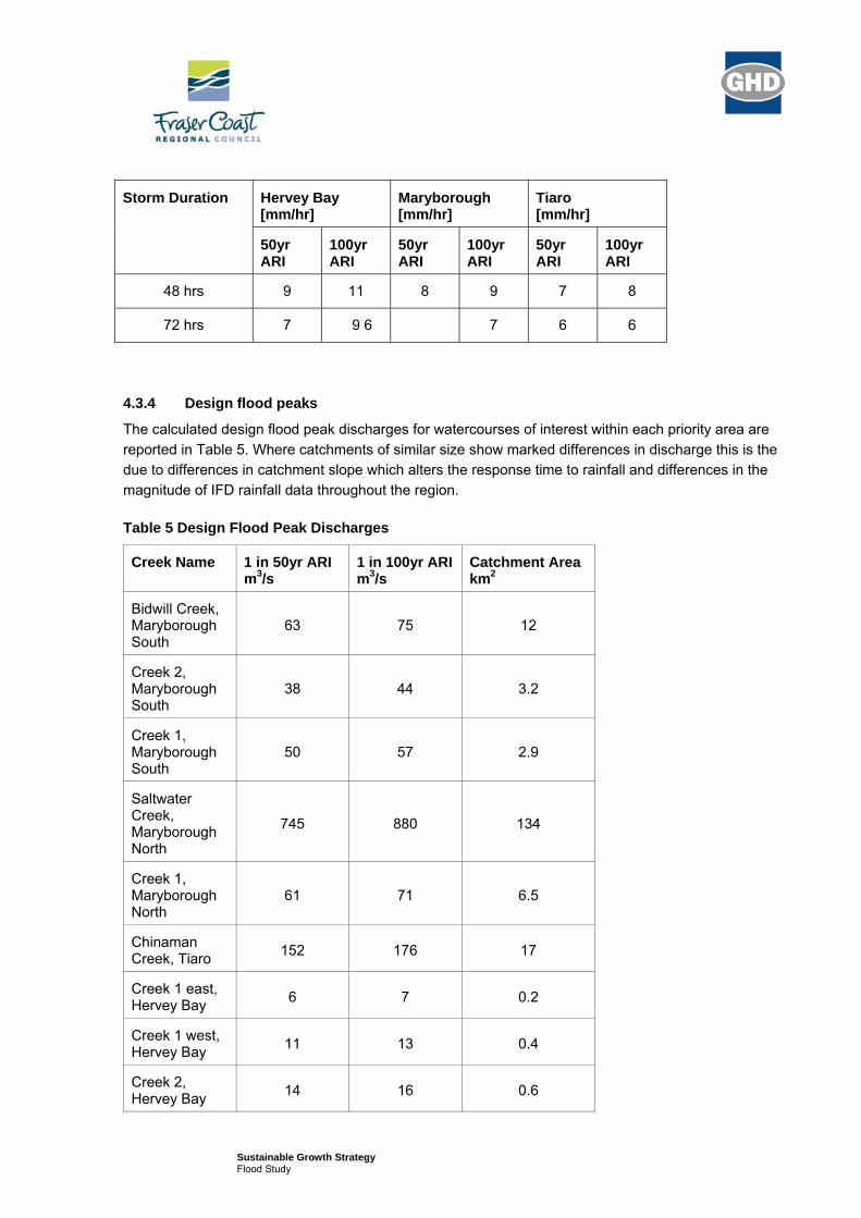
Sustainable Growth Strategy Flood Study
Storm Duration Hervey Bay [mm/hr]
Maryborough [mm/hr]
Tiaro [mm/hr]
50yr ARI
100yr ARI
50yr ARI
100yr ARI
50yr ARI
100yr ARI
48 hrs 9 11 8 9 7 8
72 hrs 7 9 6 7 6 6
4.3.4 Design flood peaks
The calculated design flood peak discharges for watercourses of interest within each priority area are reported in Table 5. Where catchments of similar size show marked differences in discharge this is the due to differences in catchment slope which alters the response time to rainfall and differences in the magnitude of IFD rainfall data throughout the region.
Table 5 Design Flood Peak Discharges
Creek Name 1 in 50yr ARI m3/s
1 in 100yr ARI m3/s
Catchment Area km2
Bidwill Creek, Maryborough South
63 75 12
Creek 2, Maryborough South
38 44 3.2
Creek 1, Maryborough South
50 57 2.9
Saltwater Creek, Maryborough North
745 880 134
Creek 1, Maryborough North
61 71 6.5
Chinaman Creek, Tiaro 152 176 17
Creek 1 east, Hervey Bay 6 7 0.2
Creek 1 west, Hervey Bay 11 13 0.4
Creek 2, Hervey Bay 14 16 0.6

Sustainable Growth Strategy Flood Study
Creek Name 1 in 50yr ARI m3/s
1 in 100yr ARI m3/s
Catchment Area km2
Creek 3 east, Hervey Bay 10 12 0.8
Creek 3 west, Hervey Bay 14 17 0.7
4.3.5 Elevation Data
A description of floodplain topography and channel geometry has been obtained from the following data sources:
1 metre contour data for the Hervey Bay area
20m grid size Digital Elevation Model for Maryborough (GHD Mary River Flood Study, 2004).
5 metre contour data for the Fraser Coast Region.
It is understood that projects are under way to compile Digital Elevation Models from LiDAR data for a large proportion of the Fraser Coast Region. Unfortunately this data was not available at the time of study.
Cross-sections through the channel and floodplain were extracted from available topographic data using 12D software. Cross sectional profiles were obtained at regular intervals along each watercourse over the length of the priority area.
Sustainable Growth Strategy Flood Study
4.3.6 Channel Roughness
Channel and floodplain roughness were described in terms of Manning’s ‘n’ values. Roughness values were based on an interpretation of aerial photography in conjunction industry standard reference values. Roughness values ranged from 0.03 within channels to 0.05 on the floodplain.
4.3.7 Boundary Conditions
The boundary condition at the upstream extent of all HEC-RAS models was defined by the flood peak discharge of upstream catchments as derived by XP-RAFTS modelling or the Rational method.
The modelled reaches within the Hervey Bay South and Tiaro areas occupy the upper catchment of watercourses where downstream boundary conditions can be defined in terms of normal flow depths using local channel gradients.
Watercourses draining the Maryborough North and Maryborough South areas flow directly into the Mary River and boundary conditions are controlled by flow conditions within the Mary River. Given the difference in catchment area between these smaller river systems and that of the Mary River it is unlikely that 1 in 100-year flood peaks would occur simultaneously. Previous modelling studies in Maryborough have used a level coinciding with the 1893 flood event (4.2m AHD) as a boundary condition for the Mary River in Maryborough. An additional boundary condition has been tested which assumes normal flow depths at the outlet of modelled reaches. Given that areas of interest are located some distance upstream of their confluence with the Mary River the difference in modelled water levels and flood extents with alternative boundary conditions was found to be small.
4.4 Model Validation
The lack of observed flood level and gauged discharge data along the watercourses being modelled has prevented the calibration of both the hydrologic and hydraulic models.
However, the results of XP-RAFTS modelling on the larger watercourses have been checked against the results of alternative methods such as the Rational method and QRT empirical method. A good agreement in the results of all three methods is achieved for Tiaro-Chinaman Creek and to a lesser extent for Maryborough North – Saltwater Creek. But there is a significant difference between the results of the three methods for Maryborough South – Bidwell Creek.
Given the discrepancy in flood estimates for Saltwater Creek and Bidwell Creek it was decided to test the sensitivity of their flood extents to the higher flood peak estimates produced by the alternative methods. This was found to have no significant impact on the flood extents.

Sustainable Growth Strategy Flood Study
5. Flood Modelling Results
5.1.1 Design flood events
HEC-RAS modelling results of flood peak water levels in local watercourses within the five priority areas have been used to map the extent of the 1 in 100-year ARI flood events. The flood outlines are shown in Figure 3 to Figure 7 together with outlines of main-river flooding from the Mary River as determined by previous studies. The flood extents of the 1 in 50-year ARI event are not shown as the difference in water surface widths to those of the 1 in 100-year ARI event is typically less than 15m which is less than the accuracy of modelling. This reflects the relatively constrained cross sectional profile of the creeks.
A comparison of the 1 in 100-year ARI event outlines from the two sources of flooding within Maryborough shows that the extent of main-river flooding (Mary River) is likely to exceed that produced by severe flood events on secondary or local watercourses.
Maryborough East appears to have no significant local drainage features and therefore flood risk is assumed to be limited to main-river flooding from the Mary River.
Flood outlines from existing studies therefore provide an adequate representation of flood risk to priority areas for the purposes of this strategic planning study. The exception is Hervey Bay South and Tiaro where flood risk from main-river flooding is absent due to their location and an indicative map of flood risk from local drainage has been provided. However, it is emphasised that these results are not intended to replace those required by more detailed stages of design.
Table 6 summarises typical water depths and velocities within the modelled reaches of the three larger watercourses passing through or adjacent to priority areas. Given the absence of significant floodplain inundation they represent conditions within the channel. Due to the strategic nature of the study and the absence of detailed topographic information these are indicative values, only.
Table 6 Indicative Flood Depth and Velocity within Channels
Creek Name 1 in 50yr ARI 1 in 100yr ARI
Depth m Velocity
m/s Depth m Velocity
m/s
Bidwill Creek, Maryborough South
1.0 – 2.2 0.5 – 1.3 1.0 - 2.3 0.6 – 1.4
Saltwater Creek, Maryborough North
3.6 – 4.6 0.6 – 1.5 3.8 – 4.9 0.6 – 1.6
Chinaman Creek, Tiaro 0.6 – 1.0 0.3 – 1.3 0.6 – 1.0 0.3 – 1.4

CHAPEL ROAD
DOOLONG ROAD
URRAWEEN ROAD
DO
OLO
NG
SO
UTH
RO
AD
GIL
STO
N R
OA
D
CHRISTENSEN STREET
MAR
YBO
ROUG
H HE
RVEY
BAY
RO
AD
MAI
N S
TRE
ET
MA
DS
EN R
OA
D
MAIKE DRIVE
IAN
AV
EN
UE
DE
NM
AN
S C
AM
P R
OA
D
SQ
UIR
E S
TRE
ET
JOHNSTON BOULEVADE
TALASEA DR
IVE
MARLIN STREET
RO
HAN
WAY
JULI
E A
NN
E S
TRE
ET
IRO
NB
AR
K S
TRE
ET
HAYDN DRIVE
ELI C
REEK
Hervey Bay South
© 2008. While GHD has taken care to ensure the accuracy of this product, GHD, GeoScience Australia and Fraser Coast Regional Council make no representations or warranties about its accuracy, completeness or suitability for any particular purpose.GHD and GHD, GeoScience Australia and Fraser Coast Regional Council cannot accept liability of any kind (whether in contract, tort or otherwise) for any expenses, losses, damages and/or costs (including indirect or consequential damage) which are or may be incurred as a result of the product being inaccurate, incomplete or unsuitable in any way and for any reason.
Fraser Coast Regional CouncilSustainable Growth Strategy
Figure 3
Job NumberRevision A
41-22108
15 JUNE 2010
Hervey Bay South 1 in100-year ARI flood outlines
Date
LEGEND
Map Projection: Transverse MercatorHorizontal Datum: Geocentric Datum of Australia
Grid: Map Grid of Australia 1994, Zone XX
G:\31\22108\GIS\Projects\Hydrology\003_Hervey_Bay_South_1in100yr_ARI_Flood.mxd
Data source: GeoScience Australia - 2010, Fraser Coast Regional Council - 2010. Created by: ADosani
180 Lonsdale Street Melbourne VIC 3000 Australia T 61 3 8687 8000 F 61 3 8687 8111 E [email protected] W www.ghd.com
C L I E N T S P E O P L E P E R F O R M A N C E
0 200 400 600 800100
Meters o1:15,000 (at A3) Priority development area
Localised 1 in 100-year ARI flood event
Previous Study 1 in 100-year ARI flood outline
Fraser Coast Regional Council Area
Roads
Highway
Railway
Water body
Water Courses
Built-Up area
Local Government Boundary

MARYBOROUGH
Maryborough North
MA
RY
BOR
OU
GH
UR
AN
GA
N R
OAD
NEPTUNE S
TREET
BRU
CE H
IGH
WAY
SA
LTW
ATE
R C
RE
EK R
OA
D
MAR
Y RI
VER
SALT
WAT
ER
CR
EE
K
MARY R
IVER
© 2008. While GHD has taken care to ensure the accuracy of this product, GHD, GeoScience Australia and Fraser Coast Regional Council make no representations or warranties about its accuracy, completeness or suitability for any particular purpose.GHD and GHD, GeoScience Australia and Fraser Coast Regional Council cannot accept liability of any kind (whether in contract, tort or otherwise) for any expenses, losses, damages and/or costs (including indirect or consequential damage) which are or may be incurred as a result of the product being inaccurate, incomplete or unsuitable in any way and for any reason.
Fraser Coast Regional CouncilSustainable Growth Strategy
Figure 4
Job NumberRevision A
41-22108
15 JUNE 2010
Maryborough North 1 in100-year ARI flood outlines
Date
LEGEND
Map Projection: Transverse MercatorHorizontal Datum: Geocentric Datum of Australia
Grid: Map Grid of Australia 1994, Zone XX
G:\31\22108\GIS\Projects\Hydrology\004_Maryborough_North_1in100yr_ARI_Flood.mxd
Data source: GeoScience Australia - 2010, Fraser Coast Regional Council - 2010. Created by: ADosani
180 Lonsdale Street Melbourne VIC 3000 Australia T 61 3 8687 8000 F 61 3 8687 8111 E [email protected] W www.ghd.com
C L I E N T S P E O P L E P E R F O R M A N C E
0 250 500 750 1,000125
Meters o1:20,000 (at A3) Priority development area
Localised 1 in 100-year ARI flood event
Main River 1 in 100-year ARI flood event
Fraser Coast Regional Council Area
Roads
Highway
Railway
Water body
Water Courses
Built-Up area
Local Government Boundary

!
MARYBOROUGHKENT STREET
ODESSA STR
EET
PALL
AS STR
EET
ANN STREET
SAL
TWAT
ER
CR
EE
K R
OA
D
GUAVA S
TREET
JOHN S
TREE
T
WOODSTOCK STREET
CAMBRIDGE STREET
LENNOX S
TREET
RICHMOND S
TREET
FERRY
LANE
UNION STREET
MARCH STR
EET
BOONOROO ROAD
TIGER
STR
EET
Maryborough East
MARY RIVER
MARY RIVER
© 2008. While GHD has taken care to ensure the accuracy of this product, GHD, GeoScience Australia and Fraser Coast Regional Council make no representations or warranties about its accuracy, completeness or suitability for any particular purpose.GHD and GHD, GeoScience Australia and Fraser Coast Regional Council cannot accept liability of any kind (whether in contract, tort or otherwise) for any expenses, losses, damages and/or costs (including indirect or consequential damage) which are or may be incurred as a result of the product being inaccurate, incomplete or unsuitable in any way and for any reason.
Fraser Coast Regional CouncilSustainable Growth Strategy
Figure 5
Job NumberRevision A
41-22108
15 JUNE 2010
Maryborough East 1 in100-year ARI flood outlines
Date
LEGEND
Map Projection: Transverse MercatorHorizontal Datum: Geocentric Datum of Australia
Grid: Map Grid of Australia 1994, Zone XX
G:\31\22108\GIS\Projects\Hydrology\005_Maryborough_East_1in100yr_ARI_Flood.mxd
Data source: GeoScience Australia - 2010, Fraser Coast Regional Council - 2010. Created by: ADosani
180 Lonsdale Street Melbourne VIC 3000 Australia T 61 3 8687 8000 F 61 3 8687 8111 E [email protected] W www.ghd.com
C L I E N T S P E O P L E P E R F O R M A N C E
0 250 500 750 1,000125
Meters o1:20,000 (at A3) Priority development area
Localised 1 in 100-year ARI flood event
Main River 1 in 100-year ARI flood event
Fraser Coast Regional Council Area
Roads
Highway
Railway
Water body
Water Courses
Built-Up area
Local Government Boundary

!
Maryborough South
MARYBOROUGH
BRUC
E HI
GHW
AY
KENT STREET
ANN STREET
CENTRAL ROAD
ALICE STREET
GYMPIE ROAD
PALL
AS STR
EET
WALKER STREET
FERRY S
TREET
LENNOX S
TREET
ODESSA STR
EET
GUAVA S
TREETFO
RT LANE
RICHMOND S
TREET
WOODSTOCK STREET
CAMBRIDGE STREET
NEPTUNE STREET
MARYBOROUGH TUAN FOREST ROAD
AMAD
OR RO
AD
MARCH STR
EET
MARY RIVER
BIDWILL CREEK
TINANA CREEK
MAR
Y RI
VER
© 2008. While GHD has taken care to ensure the accuracy of this product, GHD, GeoScience Australia and Fraser Coast Regional Council make no representations or warranties about its accuracy, completeness or suitability for any particular purpose.GHD and GHD, GeoScience Australia and Fraser Coast Regional Council cannot accept liability of any kind (whether in contract, tort or otherwise) for any expenses, losses, damages and/or costs (including indirect or consequential damage) which are or may be incurred as a result of the product being inaccurate, incomplete or unsuitable in any way and for any reason.
Fraser Coast Regional CouncilSustainable Growth Strategy
Figure 6
Job NumberRevision A
41-22108
15 JUNE 2010
Maryborough South 1 in100-year ARI flood outlines
Date
LEGEND
Map Projection: Transverse MercatorHorizontal Datum: Geocentric Datum of Australia
Grid: Map Grid of Australia 1994, Zone XX
G:\31\22108\GIS\Projects\Hydrology\005_Maryborough_East_1in100yr_ARI_Flood.mxd
Data source: GeoScience Australia - 2010, Fraser Coast Regional Council - 2010. Created by: ADosani
180 Lonsdale Street Melbourne VIC 3000 Australia T 61 3 8687 8000 F 61 3 8687 8111 E [email protected] W www.ghd.com
C L I E N T S P E O P L E P E R F O R M A N C E
0 375 750 1,125 1,500187.5
Meters o1:30,000 (at A3) Priority development area
Localised 1 in 100-year ARI flood event
Main River 1 in 100-year ARI flood event
Fraser Coast Regional Council Area
Roads
Highway
Railway
Water body
Water Courses
Built-Up area
Local Government Boundary

!
TIARO
BRUCE HIG
HWAY
MAY
NE
STR
EE
T
BRU
CE HIG
HW
AY
BRU
CE H
IGH
WAY
MARY RIVER
CHIN
AMAN
CRE
EK
BAUPLE CREEK
Tiaro East
© 2008. While GHD has taken care to ensure the accuracy of this product, GHD, GeoScience Australia and Fraser Coast Regional Council make no representations or warranties about its accuracy, completeness or suitability for any particular purpose.GHD and GHD, GeoScience Australia and Fraser Coast Regional Council cannot accept liability of any kind (whether in contract, tort or otherwise) for any expenses, losses, damages and/or costs (including indirect or consequential damage) which are or may be incurred as a result of the product being inaccurate, incomplete or unsuitable in any way and for any reason.
Fraser Coast Regional CouncilSustainable Growth Strategy
Figure 7
Job NumberRevision A
41-22108
15 JUNE 2010
Tiaro East 1 in100-year ARI flood outlines
Date
LEGEND
Map Projection: Transverse MercatorHorizontal Datum: Geocentric Datum of Australia
Grid: Map Grid of Australia 1994, Zone XX
G:\31\22108\GIS\Projects\Hydrology\007_Tiaro_East_1in100yr_ARI_Flood.mxd
Data source: GeoScience Australia - 2010, Fraser Coast Regional Council - 2010. Created by: ADosani
180 Lonsdale Street Melbourne VIC 3000 Australia T 61 3 8687 8000 F 61 3 8687 8111 E [email protected] W www.ghd.com
C L I E N T S P E O P L E P E R F O R M A N C E
0 250 500 750 1,000125
Meters o1:20,000 (at A3) Priority development area
Localised 1 in 100-year ARI flood event
Main River 1 in 100-year ARI flood event
Fraser Coast Regional Council Area
Roads
Highway
Railway
Water body
Water Courses
Built-Up area
Local Government Boundary

!
MARYBOROUGH
KENT STREET
BRU
CE H
IGH
WAY
ANN STREET
ALICE STREET
CENTRAL ROAD
WALKER STREET
PALL
AS STR
EET
GYMPIE ROAD
NEPTUNE S
TREET
FERRY S
TREET
MARYBOROUGH TUAN FOREST ROAD
SAL
TWAT
ER
CR
EE
K R
OA
D
LENNOX S
TREET
ODESSA STR
EET
FORT L
ANE
JOHN S
TREE
T
RICHMOND S
TREET
FERRY
LANE
CAMBRIDGE STREET
MORNING STREET
JUP
ITE
R S
TRE
ET
AMADOR ROAD
GAYNDAH ROAD
MARCH STR
EET
ALMA STREET
BRUC
E HIG
HW
AY
NEPTUNE STREET
JUPITER STREET
MARY RIVER
BIDW
ILL CR
EEKTINANA CREEK
MA
RY
RIV
ER
© 2008. While GHD has taken care to ensure the accuracy of this product, GHD, GeoScience Australia and Fraser Coast Regional Council make no representations or warranties about its accuracy, completeness or suitability for any particular purpose.GHD and GHD, GeoScience Australia and Fraser Coast Regional Council cannot accept liability of any kind (whether in contract, tort or otherwise) for any expenses, losses, damages and/or costs (including indirect or consequential damage) which are or may be incurred as a result of the product being inaccurate, incomplete or unsuitable in any way and for any reason.
Fraser Coast Regional CouncilSustainable Growth Strategy
Figure 8
Job NumberRevision A
41-22108
15 JUNE 2010
Maryborough 1 in100-year ARI flood outlines
Date
LEGEND
Map Projection: Transverse MercatorHorizontal Datum: Geocentric Datum of Australia
Grid: Map Grid of Australia 1994, Zone XX
G:\31\22108\GIS\Projects\Hydrology\008_Maryborough_1in100yr_ARI_Flood.mxd
Data source: GeoScience Australia - 2010, Fraser Coast Regional Council - 2010. Created by: ADosani
180 Lonsdale Street Melbourne VIC 3000 Australia T 61 3 8687 8000 F 61 3 8687 8111 E [email protected] W www.ghd.com
C L I E N T S P E O P L E P E R F O R M A N C E
0 500 1,000 1,500 2,000250
Meters o1:40,000 (at A3) Historic flood event of 1893
Previous study 1 in 100-year flood outline
Fraser Coast Regional Council Area
Roads
Highway
Railway
Water body
Water Courses
Built-Up area
Local Government Boundary
Sustainable Growth Strategy Flood Study
6. Conclusions and Recommendations
Modelling of flood outlines for localised sources of flooding has been carried out with industry standard techniques using the best available information available at the time of study. The analysis has only considered the impacts of flooding from well defined creeks and does not consider impacts from groundwater or dam failure.
The integrity of flood outlines is dependent on the accuracy of model inputs especially flood peak discharge and topographic data describing cross sectional profiles. Where possible flood peak estimates have been compared to the results produced by alternative methods. Such comparisons have highlighted some discrepancies between methods and therefore modelled flood outlines have been assessed with increased estimates of flood peak discharge. This was found to have no significant impact on flood extents.
The absence of up-to-date detailed topographic data is likely to affect the results of modelling especially those of Tiaro where reliance has been made on 5m contours for the description of channel profiles and flood extents.
No calibration of hydraulic models was possible due to the absence of recorded flood levels and flows for the reaches being modelled. However, the resolution and accuracy of modelling is considered to be commensurate with the strategic nature of the study and any shortcomings in the accuracy of input data will be of greater significance to any subsequent detailed design studies.
The comparison of flood outlines from the two sources of flooding shows that flood extents associated with localised sources of flooding are unlikely to exceed those associated with main-river flooding. Therefore, for the purposes of strategic planning no adjustment to existing 1 in 100-year ARI flood outlines was necessary except for the addition of flood extents for Hervey Bay South and Tiaro.
A flood outline based on the highest recorded flood level in 1893 is available for Maryborough. The extent of flooding defined by this historic flood event differs from that defined by the 1 in 100-year ARI design event. These differences are caused by discrepancies in what the outlines represent and in their method and accuracy of derivation. Indications are that the 1893 historic flood event is not equivalent to a 1 in 100-year ARI. Also, the method and quantity of data used to derive the extent of flooding makes the overall accuracy of the flood outline questionable.
Previous studies have reported surge plus tide plus wave setup levels for the Hervey Bay area of approximately 3.0m AHD, and 3.5m AHD with enhanced Greenhouse effects. This level is likely to increase by about 0.13m once it reaches Maryborough. This level is much lower than levels recorded during the 1893 flood event and in isolation of fluvial flood events is unlikely to cause serious flooding. Its impact in combination with fluvial flood events is unlikely to surpass that defined by the previous study 1 in 100-year ARI design flood outline given that it assumes a level in the Mary River (downstream boundary condition) of 4.2m AHD.

Sustainable Growth Strategy Flood Study
The establishment of flood risk within the study area would benefit from the following:
A more detailed and up to date digital elevation model covering the priority development areas and the contributing catchments;
An appraisal of the ARI for the 1893 Maryborough historic flood outline and thus its severity relative to design flood events.
More detailed information regarding storm tide flooding along the Mary River in conjunction with fluvial flood events.
Sustainable Growth Strategy Flood Study
7. References
Queensland Climate Change and Community Vulnerability to Tropical Cyclones – Ocean Hazards Assessment Synthesis Report (Dept of Natural Resources and Mines, August 2004).
Mary River Flood Study Interim Report for Maryborough City Council. (GHD, October 2004).
Mary River Flood Study Draft Final Report for the Maryborough City Council (GHD, July 2005).
Bunya Creek Catchment Flood Risk Reduction Study for the Hervey Bay City Council (JWP, October 2006).
Eli Creek 2D Hydraulic Study for the Hervey Bay City Council (JWP, June 2005).
Tiaro Flood Risk Assessment Study for the Tiaro Shire Council (Contour, February 2008).

Sustainable Growth Strategy Flood Study

Sustainable Growth Strategy Flood Study
GHD
201 Charlotte Street Brisbane QLD 4000 GPO Box 668 Brisbane QLD 4001 T: (07) 3316 3000 F: (07) 3316 3333 E: [email protected]
© GHD 2010
This document is and shall remain the property of GHD. The document may only be used for the purpose for which it was commissioned and in accordance with the Terms of Engagement for the commission. Unauthorised use of this document in any form whatsoever is prohibited.
Document Status
Rev No. Author
Reviewer Approved for Issue
Name Signature Name Signature Date
0 P Dunn