Executive Summary - Fraser Coast Region
50
Transcript of Executive Summary - Fraser Coast Region


Fraser Coast Active Travel Strategy 2020 Fraser Coast Regional Council
Executive Summary
By 2031, the Fraser Coast is expected to be home to 133,000 residents. As the population grows, there will be an increasing demand for Active Travel facilities as residents and visitors seek alternative modes for transport. The Active Travel Strategy identifies facilities and programmes that will accommodate and encourage further participation in Active Travel and has been created with input from the Fraser Coast community and key stakeholders within the region.
Studies into current Active Travel mode choice in the Fraser Coast region shows that the region has a high median age and reliance on electric mobility devices. Currently, approximately three quarters of the working population travel to work by car compared to a very low participation rate using Active Travel. The Fraser Coast region has an increasing footpath network and there are many opportunities to provide on-road cycling lanes.
The principles and objectives of the Active Travel Strategy have defined its vision to deliver facilities to accommodate the Fraser Region. The Strategy will deliver actions that focus on Policy, Initiatives and Infrastructure to deliver key outcomes of improving Active Travel participation rates and network connectivity.
Key actions to be delivered by the strategy include:
Investigations and pilots of supporting treatments to increase the appeal of Active Travel facilities and mode choice.
Programs to increase community Active Travel participation rates.
Promotion of events and provision of facilities to encourage Active Travel.
Delivery of Signature Projects to complete key connections in the Active Travel network.
On-going delivery of network completion works.
Investigations to identify appropriate locations for Active Travel infrastructure that supports and enhances the network.
Policy improvements to facilitate the provision and use of Active Travel infrastructure in the Fraser Coast region.
ii
Quality Record Issue Date Description Prepared By Approved By Signed A 4 Nov 2019 Draft Final A Williams D Naidu
B 30 Apr 2020 Final - Consultation D Beety D Naidu

Fraser Coast Active Travel Strategy 2020 Fraser Coast Regional Council
Table of Contents Introduction 5
What is Active Travel? 5
Purpose of the Active Travel Strategy 5
Benefits of Active Travel 5
Active Travel in Context 7
Active Travel on the Fraser Coast 7
Active Travel in Key Centres 7
The Way Forward 12
Strategic Principles 12
Active Travel Objectives 13
Strategic Approach 14
Active Travel Policy 16
Legislation 16
State Programs 16
Council Policy 16
Active Travel Initiatives 18
Supporting Treatments 18
Community Bicycle Repair Stations 18
Mobility Device Recharging Centres 18
Education Initiatives 18
Event and Economic Initiatives 20
Active Travel Infrastructure 23
The Active Travel Network Hierarchy 23
Footpaths 24
Share Paths 24
On-Road Cycling Lanes 25
iii
Future Network Plan 27
Active Travel Network Needs 27
Signature Projects 28
Delivery 30
Footpath Delivery 30
On-Road Cycling Lanes 30
Pedestrian Crossings 30
Summary of Actions 31
– Active Travel Network Hierarchy Maps
– Footpath Network Gap Analysis Maps
Appendix C – Table of Footpath Network Gaps
Appendix D – Table of Pedestrian Refuges

Fraser Coast Active Travel Strategy 2020 Fraser Coast Regional Council
4
INTR
OD
UC
TIO
N

Fraser Coast Active Travel Strategy 2020 Fraser Coast Regional Council
5
Introduction
What is Active Travel?
Active Travel includes any form of non-motorised transport that involves physical activity, with the exception of using low-powered electric devices. It includes activities such as walking, cycling, skateboarding, pushing prams and the use of mobility devices and electricity assisted bikes and scooters. The active travel network includes footpaths, shared paths, on-road cycle lanes, dedicated off-road cycle facilities and shared zones as well as sharing the use of the roadway with traffic.
Purpose of the Active Travel Strategy
By 2031, the Fraser Coast is expected to be home to 133,000 residents. As the population grows, there will be an increasing demand for Active Travel facilities as residents and visitors seek alternative modes for transport.
The Active Travel Strategy identifies facilities and programmes that will accommodate and encourage further participation in Active Travel. The aim of the Strategy is to encourage residents and visitors to view Active Travel as an acceptable and viable option for commuting and recreational travel in the Fraser Coast. The successful delivery of the Active Travel Strategy will bring a variety of health-related and economic benefits to the Fraser Coast and will work towards establishing Fraser Coast as a lifestyle community where Active Travel plays a vital role.
This Strategy has been created with input from the Fraser Coast community and key stakeholders within the region.
Note: Specialist use facilities such as mountain bike trails, skate parks, BMX tracks and isolated facilities within parklands are not included in the Active Travel Strategy.
Benefits of Active Travel
The successful implementation of the Strategy will result in increased Active Travel participation by residents and visitors. The benefits associated with increased Active Travel participation include:
Moving People: Improving Active Travel facilities and connections will increase accessibility and safety in the Fraser Coast and allow residents and visitors to choose alternative transport modes over private vehicle. Additionally, improvements to the network will enable all users to travel safely to key destinations with greater reliance on footpaths and road crossings.
Well-Being: Providing a well-connected Active Travel network will result in more residents and visitors participating in moderate to intensive physical activity on a daily basis. Programs and initiatives are designed to enhance the community’s participation and use of these facilities.
Environment: Active Travel is conducive to reducing congestion and improving traffic flow as people move away from reliance on private vehicles. Cities and towns with high levels of Active Travel have been proven to have less congestion and greater air quality than that of cities with a high dependency on private vehicles.
Economic: Transport is one of the most significant items of household expenditure in Australia. Active Travel is relatively inexpensive for users and for local governments to deliver infrastructure. New special purpose families such as rail trails, as well as well connected communities create tourism opportunities, such as cycle-tourism, which adds significant economic benefits.
Social: Active Travel supports social interactions and can make users feel more at home in their community. The ability to travel safely and independently is an important way to address issues such as social isolation, loneliness and depression. Increased participation rates in Active Travel can result in creating vibrant and welcoming communities.

Fraser Coast Active Travel Strategy 2019 Fraser Coast Regional Council
6
AC
TIV
E TR
AV
ELIN
CO
NTE
XT

Fraser Coast Active Travel Strategy 2020 Fraser Coast Regional Council
7
Active Travel in Context
Active Travel on the Fraser Coast
Studies were completed to understand how the residents of the Fraser Coast currently participate in Active Travel and to identify the current status of the network. The key findings of the study are shown below.
Active Travel in Key Centres
Hervey Bay
As the largest urban centre in the Fraser Coast region, Hervey Bay has the most extensive Active Travel network. Key routes include the Links Mobility Corridor and the North-South Mobility Corridor. The most significant Active Travel attractor for the region is the Hervey Bay Recreational Trail, a foreshore shared pathway that traverses the entire length parallel to the Esplanade and connects key destinations that include Wetside Water Park, Uranguan Pier and Dundowran Beach.
There are opportunities to improve on-road cycling facilities (which are limited) as well as off-road facilities (such as shared paths and dedicated cycle paths) that support north-south Active Travel trips, particularly in the eastern suburbs of Torquay and Urangan. Additionally, there are various infrastructure gaps in the
southern areas of Hervey Bay that are zoned for future development, which means that corridors in these areas need to be prioritised for delivery of Active Travel infrastructure as future developments emerge.
Fraser Coast Active Travel Strategy 2020 Fraser Coast Regional Council
8
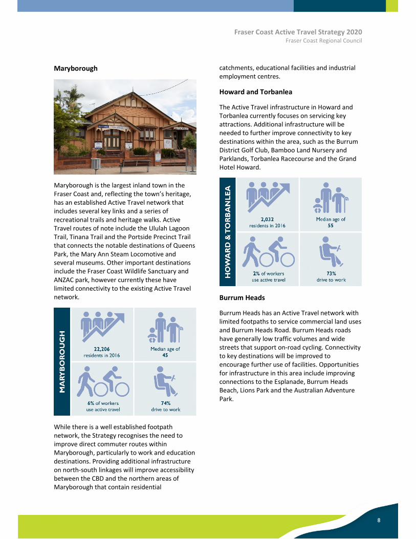
Maryborough
Maryborough is the largest inland town in the Fraser Coast and, reflecting the town’s heritage, has an established Active Travel network that includes several key links and a series of recreational trails and heritage walks. Active Travel routes of note include the Ululah Lagoon Trail, Tinana Trail and the Portside Precinct Trail that connects the notable destinations of Queens Park, the Mary Ann Steam Locomotive and several museums. Other important destinations include the Fraser Coast Wildlife Sanctuary and ANZAC park, however currently these have limited connectivity to the existing Active Travel network.
While there is a well established footpath network, the Strategy recognises the need to improve direct commuter routes within Maryborough, particularly to work and education destinations. Providing additional infrastructure on north-south linkages will improve accessibility between the CBD and the northern areas of Maryborough that contain residential
catchments, educational facilities and industrial employment centres.
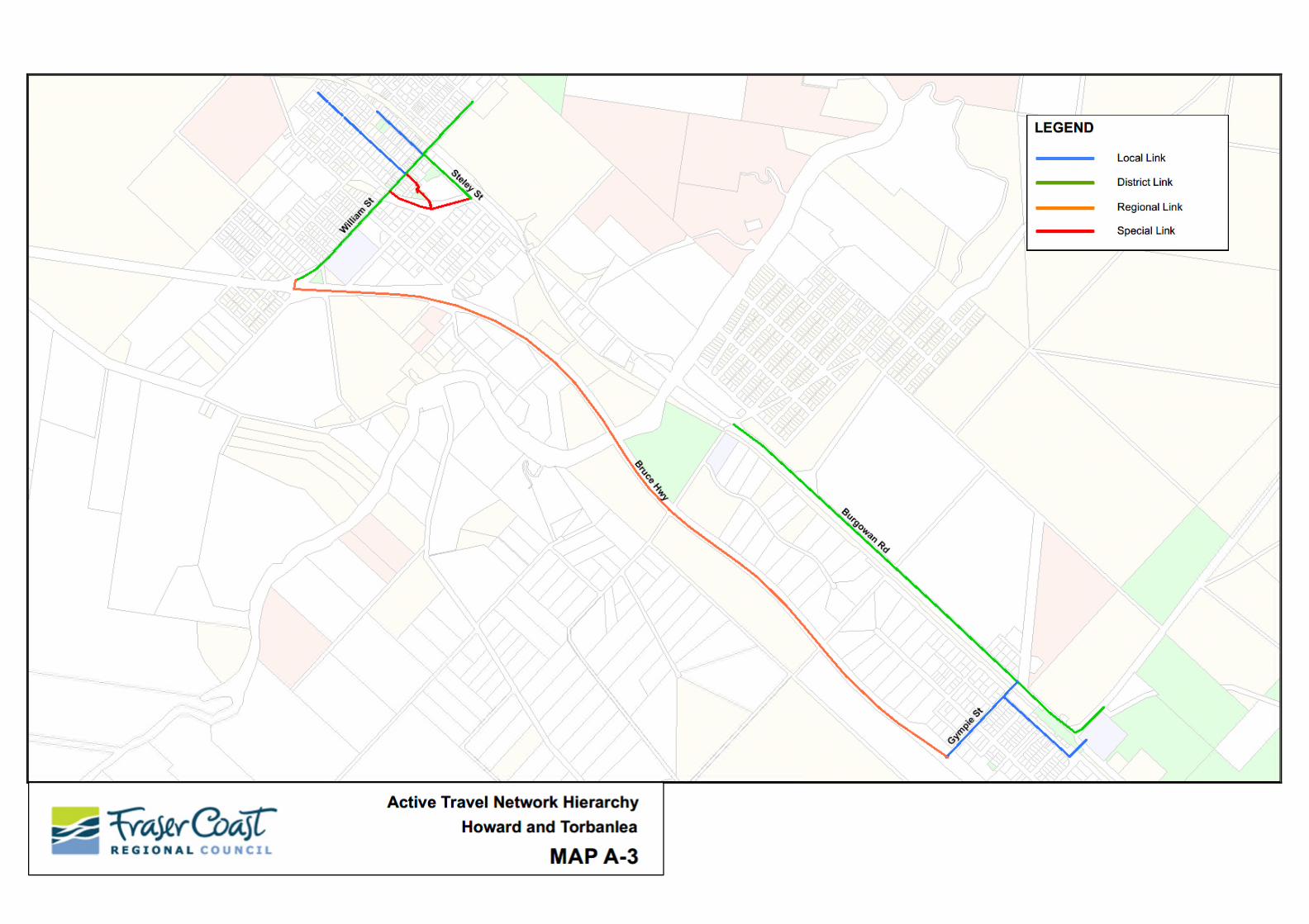
Howard and Torbanlea
The Active Travel infrastructure in Howard and Torbanlea currently focuses on servicing key attractions. Additional infrastructure will be needed to further improve connectivity to key destinations within the area, such as the Burrum District Golf Club, Bamboo Land Nursery and Parklands, Torbanlea Racecourse and the Grand Hotel Howard.
Burrum Heads
Burrum Heads has an Active Travel network with limited footpaths to service commercial land uses and Burrum Heads Road. Burrum Heads roads have generally low traffic volumes and wide streets that support on-road cycling. Connectivity to key destinations will be improved to encourage further use of facilities. Opportunities for infrastructure in this area include improving connections to the Esplanade, Burrum Heads Beach, Lions Park and the Australian Adventure Park.
Fraser Coast Active Travel Strategy 2020 Fraser Coast Regional Council
9
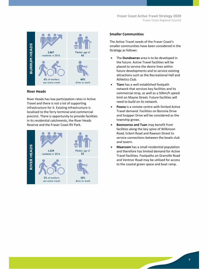
River Heads
River Heads has low participation rates in Active Travel and there is not a lot of supporting infrastructure for it. Existing infrastructure is localised to the ferry terminal and commercial precinct. There is opportunity to provide facilities in its residential catchments, the River Heads Reserve and the Fraser Coast RV Park.
Smaller Communities
The Active Travel needs of the Fraser Coast’s smaller communities have been considered in the Strategy as follows:
The Dundowran area is to be developed in the future. Active Travel facilities will be placed to service the desire lines within future developments and to service existing attractions such as the Recreational Hall and Athletics Club.
Tiaro has a well established footpath network that services key facilities and its commercial strip, as well as a 50km/h speed limit on Mayne Street. Future facilities will need to build on its network.
Poona is a remote centre with limited Active Travel demand. Facilities on Boronia Drive and Snapper Drive will be considered as the township grows.
Boonooroo and Tuan may benefit from facilities along the key spine of Wilkinson Road, Eckert Road and Rawson Street to service connections between the bowls club and tavern.
Maaroom has a small residential population and therefore has limited demand for Active Travel facilities. Footpaths on Granville Road and Ventnor Road may be utilised for access to the coastal green space and boat ramp.

Fraser Coast Active Travel Strategy 2020 Fraser Coast Regional Council
10

Fraser Coast Active Travel Strategy 2020 Fraser Coast Regional Council
11
THE
WA
Y F
OR
WA
RD

Fraser Coast Active Travel Strategy 2020 Fraser Coast Regional Council
12
The Way Forward
Our vision is to provide a safe, connected and innovative Active Travel network that provides equitable accessibility on the Fraser Coast. Our Active Travel network will embrace the unique Fraser Coast lifestyle and allow residents and visitors to travel effortlessly between destinations as a viable alternative to car travel.
Strategic Principles
A set of key principles has been developed to guide the Strategy and deliver an Active Travel network that meets the current and future needs of the Fraser Coast.
The key principles for the strategy include:
Governance: Ensure effective forward planning, project management and effective management of people, assets and finances.
Lifestyle: Support the needs of residents and visitors on the Fraser Coast, open new opportunities for all residents and visitors to participate in the vibrant Fraser Coast lifestyle, and provide equitable access to community facilities.
Prosperity: Build an Active Travel network that supports the diverse Fraser Coast community and the continued growth of the region. Invest in innovative projects to increase Active Travel participation and capitalise on opportunities in the growing tourism industry.
Natural Environment: Apply sustainable practices to minimise environmental impacts, connect the community and visitors to the unique natural environmental of Fraser Coast.
Built Environment: Provide resilient infrastructure that supports current and future needs of the region, is sustainable and contributes to vibrant communities.

Fraser Coast Active Travel Strategy 2020 Fraser Coast Regional Council
13
Active Travel Objectives
Objectives for Active Travel on the Fraser Coast were formed based on the community’s feedback and consideration of the strategic vision:
Safe: The Active Travel network shall provide a safe means of travel for all users. Users will not be exposed to hazards and high-speed road environments. People of all ages will be able to travel with peace of mind.
Connected: Key routes shall be connected to ensure that links within the Active Travel network either directly or indirectly connect via other links. Isolated Active Travel connections will be avoided where possible.
Legible: The Active Travel network shall be both intuitive and direct, with links easy to navigate. Routes shall be located parallel to existing infrastructure that enables access to destinations, including major road or rail corridors or natural landforms such as coastlines, parklands or rivers.
Accessible: The Active Travel network will be easily accessible by all users and will encourage participation. New infrastructure will be compliant with accessibility requirements and existing infrastructure will be upgraded as part of Council’s programs where practical.
Value-for-money: Active Travel infrastructure projects must be fit for purpose. Construction and ongoing maintenance costs will be balanced against the potential level of use and community benefit.
Captivating: Active Travel infrastructure should not only meet demand but enhance public space to inspire community participation in Active Travel.

Fraser Coast Active Travel Strategy 2020 Fraser Coast Regional Council
14
Strategic Approach
In addition to delivering infrastructure to support movement across the Active Travel network, Council will be adopting new or changing its current strategic policies, as well as proceeding with the implementation of programmes and initiatives that facilitate, enhance or encourage Active Travel in the Fraser Coast. These actions will be delivered as part of the core delivery elements of Policy, Initiatives and Infrastructure.
Policy - This strategy has been prepared to closely align with the planning and policy documents that Council and the Queensland Government currently have in place. Where possible, Council will make improvements to its existing policies to remove potential barriers to establishing Active Travel facilities and programs. State programs and initiatives have also been considered in route planning.
Initiatives - The establishment of programs and initiatives can increase the appeal of Active Travel as a travel mode choice and raise awareness of its benefits. A number of programs and initiatives have been developed to facilitate behaviour change, engage and connect with the community and enhance infrastructure through innovative approaches
Infrastructure - For Active Travel to be perceived as a viable mode of transport for commuting and recreation, the Active Travel network needs to be complete. The future approach to delivering infrastructure considers the objectives of the strategy and will provide connectivity along key Active Travel corridors in the Fraser Coast region.
The successful delivery of the strategy will result in the following key outcomes:

Fraser Coast Active Travel Strategy 2020 Fraser Coast Regional Council
15
AC
TIV
E TR
AV
ELP
LAN
NIN
G &
PO
LIC
Y

Fraser Coast Active Travel Strategy 2020 Fraser Coast Regional Council
16
Active Travel Policy
Legislation
Key legislation in relation to delivery of information and use of Active Travel includes:
Disability Discrimination Act (1992) –Council will provide a safe and accessible network for all users. Compliance improvements will be incorporated into existing works programs.
As the popularity and ease of accessibility to electric bicycles and scooters increases, Council may need to reconsider local laws to accommodate demand. This would not be unprecedented; In 2018, Brisbane City Council relaxed local laws to allow the use of electric scooters on footpaths.
Council may also consider methods to increase awareness of laws for motorists passing bicycle riders. This may encourage less-confident cyclists to ride more often.
Our region’s high reliance on mobility devices means that it is important that all users are aware of the registration requirements for motorised wheelchairs.
State Programs
The Queensland Government has programs in place to encourage investment into Active Travel facilities, with the objective of increasing participation in Active Travel. Where possible, Council will utilise the following grants programs to deliver infrastructure:
Cycle Network Local Government Grants
Rail Trail Local Government Grants Program
Council Policy
Council will ensure its policies and procedures influence the improvement, use and promotion of changes to the Active Travel network. Relevant policies include (but are not limited to):
Emerging Community Local Plan Area Infrastructure Agreement Policy
Infrastructure Charges Incentives Policy 2019
Grant Applications Procedure
Investment Attraction Incentive Policy
Use of Road Reserves (Nature Strips) for Streetscape Improvement Policy
Strategy Actions
POL-1 Incorporate accessibility improvements into Council’s existing works programs.
POL-2 Consider amendments to local laws to enable legal use of electric devices that are used for Active Travel.
POL-3 Take advantage of State grant funding policies to deliver Active Travel infrastructure where feasible and where delivery will result in outcomes that align with Council’s Corporate Plan principles.
POL-4 Amend the Infrastructure Charges Incentives Policy to encourage developers to implement Active Travel facilities into planning and design.
POL-5 Review the Use of Road Reserves (Nature Strips) for Streetscape Improvement policy to identify if any element conflicts with provision of safe and uninterrupted Active Travel facilities and amend to remove potential conflicts.

Fraser Coast Active Travel Strategy 2019 Fraser Coast Regional Council
17
AC
TIV
E TR
AV
EL
PR
OG
RA
MS
& IN
ITIA
TIV
ES

Fraser Coast Active Travel Strategy 2020Fraser Coast Regional Council
Active Travel Initiatives
While having access to well-connected Active Travel infrastructure can encourage the uptake of Active Travel, building infrastructure does not necessarily guarantee an increased participation rate. In addition to continuing to expand and improve the network, Council will be actioning programs and initiatives to encourage behavioural change and remove barriers towards participation. Initiatives will promote Active Travel as a viable means for commuting and utility trips. Initiatives are designed to encourage routine use in addition to recreational use.
Supporting Treatments
Supporting treatments can improve the amenity of existing routes and remove barriers that may prevent potential users from participating in Active Travel through provision of facilities. The treatments may improve safety, provide utility along a route or include end of trip facilities at destinations.
Environmental Footpath Lighting
The use of environmental footpath lighting can increase the appeal of utilising Active Travel routes at night. Lighting can enhance public areas to increase the perception of security and discourage unsocial behaviour in areas that may have been previously perceived as unsafe.
The use of smart lighting devices will be considered at Ululah Park in Maryborough. If feasible, they will be positioned to reduce ambient light levels at late hours to avoid disruption to residents, fauna and flora.
Community Bicycle Repair Stations
Community bicycle repair stations are unmanned, low maintenance facilities that provide cyclists with a workbench to conduct basic repairs and maintenance to bicycles (flat tyres and brake and derailleur adjustments). These stations can encourage Active Travel by providing potential users with a sense of security that they can travel between locations and account for minor maintenance issues.
Mobility Device Recharging Centres
Mobility Device Recharging Centres provide a means for users to recharge their mobility devices at destinations and remove potential barriers that may normally deter the user from travelling long distances. Recharging centres can be established within dedicated areas such as public spaces which have high usage by elderly citizens, for example libraries and community centres. This initiative can reduce social isolation, particularly for the elderly, by encouraging mobility device users to congregate at designated locations.
Education Initiatives
Council will support initiatives that raise awareness of the benefits Active Travel benefits and influence a positive attitude towards it from a young age. Enabling younger generations to partake in Active Travel generally leads to a higher participation later in life and is encouraged as a means of achieving daily physical activity requirements.
18

As part of Council’s Smart Communities program, conduct a benefits analysis of installing smart lighting in Ululah Park in Maryborough, with the goal of lighting key activity areas while limiting disruption to residents, flora and fauna.
Undertake a pilot study of the installation of bicycle repair stations along the Hervey Bay mobility corridor or the future Mary to Bay Rail trail to determine effectiveness and cost-benefits associated with bicycle repair stations.
Run a pilot program to incorporate a Mobility Device Recharging Centre at a Council owned facility such as the Hervey Bay Community Centre. As part of the pilot study development, consult with operators of similar facilities.
Engage with the Department of Education, TMR and local schools to trial a Walking Bus pilot program with one school in Hervey Bay and one school in Maryborough.
Engage with primary schools to identify improvements that can be implemented to increase participation rates for Walk, Ride and Scoot to School Days.
Nominate a Fraser Coast wide Walk, Ride and Scoot to School Day and use social media channels to promote it.
INI-1 •
INI-2 •
INI-3 •
INI-4 •
INI-5 •
INI-6 •
19
Fraser Coast Active Travel Strategy 2020 Fraser Coast Regional Council
Walking School Buses
Walking School Bus programs establish walking groups of primary school children to travel to and from school along a designated route with “stops” for new passengers to enter the walking bus.
This initiative will provide children with an opportunity participate in a physical and social activity on a recurring basis. Similar initiatives have been used successfully in Cairns and Logan. Edens Landing State School (in the Logan municipality) has an ongoing Walking Bus program that involves collaboration with the Queensland Police Service, school teachers and volunteers to ensure that participating children are safely accompanied to and from school.
Walk, Ride and Scoot to School Day
Walk, Ride and Scoot to School Days are recurring events where students are encouraged to commute safety to school by Active Travel modes.
Council will engage with Fraser Coast schools to organise a region wide Walk, Ride and Scoot to School Day. The Walk, Ride and Scoot to School Day has potential to be a regular community event that can drive a cultural change that highlights Active Travel as a safe transport mode for students.
Strategy Actions

Fraser Coast Active Travel Strategy 2020 Fraser Coast Regional Council
20
Active Travel Path Markers
Active Travel Path Markers are permanent pavement markings that ensure commuter routes are clearly signed with key destinations, wayfinding and safety information for route users. Use of the markers along school access routes will provide a clear, concise and fun method for students to travel to school, as well as increase the confidence of younger children to travel to school through a means of walking or cycling. The markers may contain information such as distance left until the destination is reached.
Community Information Access
Council will investigate the creation of an Active Travel website and information hub. The website will provide residents and visitors with information on how to access popular Active Travel routes and the unique destinations that the Fraser Coast region offers.
The Active Travel website will also allow for local community groups (such as Bicycle User Groups) to promote themselves and group events. The City of Gold Coast has implemented a cycling website that provides information on topics such as its bike share scheme, maps and guides, cycling workshops and events, how to prevent bike theft and riding safely.
Event and Economic Initiatives
Promotion of Active Travel events and economic initiatives can encourage Active Travel while showcasing the Fraser Coast to visitors and enhancing the reputation of the region. Active Travel can be used in conjunction with the Fraser Coast Regional Events Strategy, providing guidance on developing calendar events that attract visitors and establish the region as a leader in regional Active Travel.
As the Fraser Coast region already hosts many events each calendar year, the initiatives detailed in this strategy are also means to promote Active Travel for existing events.
Portable End of Trip Facilities
Currently, it is difficult for the community to access local events using Active Travel due to the absence of End of Trip facilities at the events. Council will investigate the provision of Portable End of Trip facilities at events. This will include temporary bicycle parking and associated facilities.
Strategy Actions
INI-7 Identify a primary school to participate in a pilot program for Active Travel Path Markers.
INI-8 Establish an Active Travel section on Council’s website that provides information on facilities, popular routes, Active Travel events and activities.
INI-9 Undertake design, cost estimation and scoping for management and maintenance of a portable bicycle parking facility and identify future regional events for initial trial use.

Fraser Coast Active Travel Strategy 2020 Fraser Coast Regional Council
21
Increased Promotion of Running and Cycling Events
On-going promotion of running and cycling events will continue to raise awareness of Active Travel in the Fraser Coast region. Events will be promoted on the previously detailed Active Travel website, with information provided on how to travel to the event via Active Travel and what end-of-trip facilities are available at the event.
In addition to the current schedule of events, Council will investigate establishing a new event that promotes a non-demanding level of Active Travel participation and is attached to a charitable cause that the community will support. Holding these types of events will help to raise awareness around the diverse nature of demands for Active Travel and high demand for mobility scooter use in the Fraser Coast.
Strategy Actions
INI-10 Continue to promote events in the Fraser Coast region that encourage a healthy and active lifestyle.
INI-11 Develop and promote a new Active Travel event that encourages participants of all levels of ability and modes of Active Transport.

Fraser Coast Active Travel Strategy 2020 Fraser Coast Regional Council
22
AC
TIV
ETR
AV
ELIN
FRST
RU
CTU
RE

Fraser Coast Active Travel Strategy 2020 Fraser Coast Regional Council
23
Active Travel Infrastructure
The Active Travel Network Hierarchy
The maps at Appendix A show the Fraser Coast Active Travel Network.
At a high-level, the Active Travel network is a collection of links that serve a purpose of movement across large distances or connection between movement corridors and destinations. The links of the Fraser Coast network are classified in a hierarchy that is based on function. This classification system allows for Council to assess the infrastructure needs of key network links on a fit-for-purpose basis. The classifications include:
Local links
District links
Regional links
Special links
Links of the same classification are not guaranteed to have an identical form and infrastructure provision, but will serve the same purpose. When planning and designing infrastructure for these links, Council often will consider issues such as speed, volumes of cars, demand for Active Travel, width of roads and the cost benefit of different forms of path widths, type and locations.
Local Links
Local links form the majority of the Fraser Coast Active Travel network, collecting users and connecting them to district, special and regional network routes. They are typically located in residential catchments and provide last mile connections from higher order routes and regional catchments. These routes may also be used to access local amenities, such as shops, parks and community centres, where demand may not warrant high grade facilities to access.
District Links
District links serve the primary purpose of movement over large distances, connecting urban residential and regional catchments with large attractors with minimal interruptions. They support direct, convenient and connected routes for high levels of use between key destinations and should be viewed as ‘Active Travel arterials’.

Fraser Coast Active Travel Strategy 2020Fraser Coast Regional Council
Regional Links
Regional links facilitate long-distance trips, providing inter-regional connections that typically follow major road corridors between regions. These links connect regional catchments to urban precincts and provide connections to areas that may otherwise be isolated from the network.
Footpaths
The strategy aims to expand the current footpath network in the Fraser Coast and upgrade it where reasonable to ensure that equitable accessibility is provided on the network. The footpath network will provide access to key Active Travel links and destinations.
Given the significant distances that separate the core urban centres in the Fraser Coast, they are not anticipated to be used by high volumes of Active Travel users for commuting purposes (in comparison to urban links) and primarily serve as leisure or sports activity trips for cycling and walking.
Share Paths
Shared paths are footpaths that are wider than normal. These paths allow for users to comfortably pass one another. Shared paths will be included on key links where there is a high demand for Active Travel (such as District links).
Special Links
Special links provide a unique experience for users and typically showcase landmarks and natural landscapes such as watercourses, rail corridors, historic locations and viewpoints. They may overlap with existing areas of high Active Travel use and may further facilitate the growth of eco-tourism, cater for recreational user groups and provide a recreational asset for the local community.
2 4

Fraser Coast Active Travel Strategy 2020 Fraser Coast Regional Council
25
On-Road Cycling Lanes
On-road cycling lanes will be provided on high-activity corridors, where space permits. The provision of cycling lanes is typically appropriate for District links. Links identified as priority routes within the State’s Principal Cycle Network Plan will undergo feasibility investigations, as they may be eligible for funding.
Pedestrian Crossings
The safe passage of pedestrians is a high priority. Council will investigate the delivery of pedestrian crossing facilities at high-activity locations in the Fraser Coast. These include refuge islands, zebra crossings, signalised crossings and shared zones.

Fraser Coast Active Travel Strategy 2020 Fraser Coast Regional Council
26
FUTU
RE
NET
WO
RK
PLA
N

Fraser Coast Active Travel Strategy 2020Fraser Coast Regional Council
Future Network Plan
Active Travel Network Needs
As the median age of the Fraser Coast region is increasing, the provision of Active Travel facilities in all regions will need to prioritise accessibility and connectivity of footpaths and shared paths (including for mobility devices). However, on road cycling facilities will also be provided where possible.
Hervey Bay
In Hervey Bay, the key links that will be focused on are:
Denmans Camp Road & Doolong South, which serves a key north-south linkage from Wondunna to Torquay.
Urraween and Boundary Road, which provides a full east-west link servicing hospitals, schools and emerging communities
Scrub Hill Road, which provides a north south link between Pialba Burrum Heads to Urraween Road and will service two schools.
Maryborough
As part of the Strategy, Council will be investigating the provision of facilities at the following locations in Maryborough:
Pallas Street and Neptune Street, which both provide a key north-south connection to a considerable residential catchment in the north of Maryborough.
Ann Street, which serves as a key east west connection from Ululah Lagoons and access to or bypass of the CBD.
Banana Street and Wolseley Street to complete the loop around Granville
Howard and Torbanlea
Future works to deliver Active Travel facilities in Howard and Torbanlea include:
this route can utilise off-road facilities throughout the corridor.
Provision of footpaths on Burgowan Road and Gympie Street to enable improved connectivity to Torbanlea State School.
Burrum Heads
As the Burrum Heads community is small and isolated from higher density areas, the requirement for on-road cycle facilities is not critical and infrastructure delivery should focus on establishing off-road connectivity at locations such as the Esplanade, Burrum Heads Beach, Lions Park and the Australian Adventure Park.
Additionally, the establishment of a connection along Burrum Street, Bushnell Road and Orchid Drive to connect residential uses in the north and south of the region will be considered.
River Heads
Future improvements to Active Travel connectivity in this region is likely to involve the provision of off-road infrastructure in residential catchments, the River Heads Reserve and the Fraser Coast RV Park to the existing network at the commercial precinct.
Smaller Communities
Council will consider inexpensive and unobtrusive options to encourage Active Travel (such as lowering speed limits). The identified needs of the smaller communities are as follows:
The Dundowran area is to be developed in the future. Active Travel facilities will be placed to service the desire lines within future developments and to service existing attractions such as the Recreational Hall and Athletics Club.
Tiaro has an existing footpath network that services key facilities and its commercial strip, as well as a 50km/h speed limit on Mayne Street. Future development will provide Active Travel facilities that link to the existing network.
Poona is a remote centre with limited Active Travel demand. Facilities on Boronia Drive and Snapper Drive may receive some
2 7

Fraser Coast Active Travel Strategy 2020Fraser Coast Regional Council
activity to and from the cricket grounds and caravan park.
Boonooroo and Tuan may benefit from facilities along the key spine of Wilkinson Road, Eckert Road and Rawson Street to service connections between the bowls club and tavern.
Maaroom has a small residential population and therefore has limited demand for Active Travel facilities. Footpaths on Granville Road and Ventnor Road may be utilised for access to the coastal green space and boat ramp.
2 8
Signature Projects
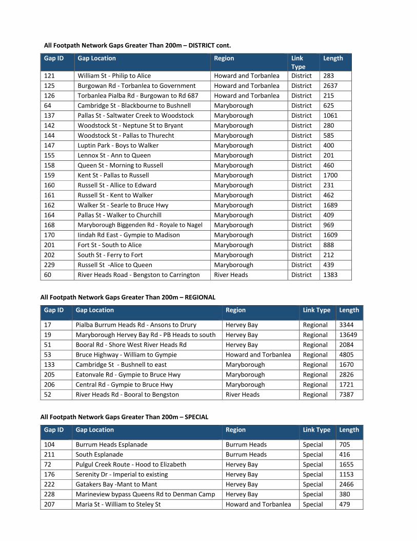
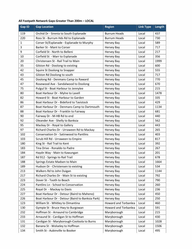
Council have identified 20 locations where prioritised construction of new footpaths, shared paths or cycle lanes will complete key connections in the Fraser Coast Active Travel Network and provide benefits to the region. These Signature Projects were selected through a process of stakeholder consultation and multicriteria analysis of infrastructure gaps (shown in the maps at Appendix B) within the network. Works will focus on providing footpaths where there are no current facilities as well as upgrading existing facilities to desired standards. While the location of these projects have been defined, as this is a high order assessment it may be necessary during design to alter the ultimate route due to constraints beyond the scope of this strategy.

2 9
Fraser Coast Active Travel Strategy 2020 Fraser Coast Regional Council
The Signature Projects are outlined below.
PRIORITY LOCALITY EXTENTS LENGTH (m)
1 Urraween Road, Hervey Bay Scrub Hill Road to Hudson Drive 1460
2 Boundary Road Extension, Hervey Bay Kawungan Way to Denmans Camp 1960
3 Boundary Road, Hervey Bay Denmans Camp Road to Elizabeth Street 1360
4 Esplanade, Hervey Bay Hood Street to Elizabeth Street 2010
5 Denmans Camp Road, Hervey Bay Doolong Road to Gordon Street 780
6 Serenity Drive, Hervey Bay* Pialba Burrum Heads Rd to Imperial Cct 230
7 Scrub Hill Road, Hervey Bay* Pialba Burrum Heads Rd to Urraween Rd 820
8 Boat Harbour Drive, (West) Hervey Bay Nissen Street to Ibis Boulevard 1480
9 Neptune Street, Maryborough Walker Street to Victory Street 1330
10 Ann Street, Maryborough Cheapside Street to March Street 2000
11 Doolong South Road, Hervey Bay* Maggs Hill Road to Doolong Road 2170
12 Boat Harbour Drive, (East) Hervey Bay Denman Camp Road to Lavelle Street 1480
13 Madsens Road, Hervey Bay* Chapel Road to Urraween Road 1580
14 Corser Street, Hervey Bay Mant Street to Esplanade 2470
15 Ariadne Street, Maryborough Victory Street to Churchill Street 1380
16 Raward Road, Hervey Bay Boundary Road to Gilston Road 1930
17 Truro Street, Hervey Bay Bideford Street to Margaret St 1660
18 Cambridge Street, Maryborough Blackburn Street to Bushnell 1020
19 Springs Estate, Hervey Bay* Madsen Road to Main Street 1660
20 Banana Street, Maryborough Wolseley Street to Hoffman Street 1510
* Subject to Development, the timing for these projects may change. This would allow for other projects to be added to this list following a review
Strategy Actions
NF-1 • Deliver the Signature Projects within the horizon of the Active Travel Strategy based on the priority ranking above.
INF-2 • Commit to delivering Network Completion Projects as complimentary works in maintenance related tasks.
INF-3 • Undertake investigations to categorise District type links into short-term, medium-term and long-term projects, and deliver cycle lanes on District type links with a focus on the Principal Cycle network.
INF-4 • Undertake investigations of District type links to identify suitable locations for mid-block crossings.
INF-5 • Undertake feasibility investigations for the provision of intersection crossing facilities around high pedestrian activity generating land uses.
INF-6 • Identify future funding requirements with forward planning to clearly identify repairs, maintenance and minor works estimates in addition to new network infrastructure.

Fraser Coast Active Travel Strategy 2020Fraser Coast Regional Council
Delivery
Footpath Delivery
Council will prioritise the delivery of footpaths using its Capital Works program. Signature Projects will deliver footpaths in key areas on the network. The remaining links of the Active Travel network will be delivered as part of Council’s on-going works and maintenance programs.
On-Road Cycling Lanes
Cycling lanes will be delivered on existing District links in the Active Travel network where large-scale works are not required and the impact to the road environment is not significant. Infrastructure on links that are nominated as priority routes within the State’s Principal Cycle Network Plan (and therefore eligible for funding) will undergo feasibility investigations to determine if infrastructure costs are not prohibitive.
Future planning of road spaces will consider the inclusion of on-road cycling lanes where it is appropriate.
Pedestrian Crossings
Investigations will be undertaken to identify high-pedestrian-activity areas that do not have crossing facilities to allow for safe crossings. Maintenance of the Network
Maintenance of the Network
As the Active Travel network grows, there will be a need for on-going maintenance to ensure that it is absent of hazards and accessible by all users. Maintenance works will include upgrades to existing facilities to ensure accessibility, where it is reasonable to do so.
Council already has and will continue maintenance of vegetation, overhanging trees, removal of hazards such as roots and cracks and clearing of paths to ensure surfaces are not slippery.
30

31
Fraser Coast Active Travel Strategy 2020 Fraser Coast Regional Council
Summary of Actions
Strategy Actions
POL-1 Incorporate accessibility improvements into Council’s existing works programs.
POL-2 Consider amendments to local laws to enable legal use of electric devices that are used for Active Travel.
POL-3 Take advantage of State grant funding policies to deliver Active Travel infrastructure where feasible and where delivery will result in outcomes that align with Council’s Corporate Plan principles.
POL-4 Amend the Infrastructure Charges Incentives Policy to encourage developers to implement Active Travel facilities into planning and design.
POL-5 Review the Use of Road Reserves (Nature Strips) for Streetscape Improvement policy to identify if any element conflicts with provision of safe and uninterrupted Active Travel facilities and amend to remove potential conflicts.
INI-1 As part of Council’s Smart Communities program, conduct a benefits analysis of installing smart lighting in Ululah Park in Maryborough, with the goal of lighting key activity areas while limiting disruption to residents, flora and fauna.
INI-2 Undertake a pilot study of the installation of bicycle repair stations along the Hervey Bay mobility corridor or the future Mary to Bay Rail trail to determine effectiveness and cost-benefits associated with bicycle repair stations.
INI-3 Run a pilot program to incorporate a Mobility Device Recharging Centre at a Council owned facility such as the Hervey Bay Community Centre. As part of the pilot study development, consult with operators of similar facilities.
INI-4 Engage with the Department of Education, TMR and local schools to trial a Walking Bus pilot program with one school in Hervey Bay and one school in Maryborough.
INI-5 Engage with primary schools to identify improvements that can be implemented to increase participation rates for Walk, Ride and Scoot to School Days.
INI-6 Nominate a Fraser Coast wide Walk, Ride and Scoot to School Day and use social media channels to promote it.
INI-7 Identify a primary school to participate in a pilot program for Active Travel Path Markers.
INI-8 Establish an Active Travel section on Council’s website that provides information on facilities, popular routes, Active Travel events and activities.
INI-9 Undertake design, cost estimation and scoping for management and maintenance of a portable bicycle parking facility and identify future regional events for initial trial use.
INI-10 Continue to promote events in the Fraser Coast region that encourage a healthy and active lifestyle.
INI-11 Develop and promote a new Active Travel event that encourages participants of all levels of ability and modes of Active Transport.
INF-1 Deliver the Signature Projects within the horizon of the Active Travel Strategy based on the priority ranking above.

Fraser Coast Active Travel Strategy 2020 Fraser Coast Regional Council
32
Strategy Actions
INF-2 Commit to delivering Network Completion Projects as complimentary works in maintenance related tasks.
INF-3 Undertake investigations to categorise District type links into short-term, medium-term and long-term projects, and deliver cycle lanes on District type links with a focus on the Principal Cycle network.
INF-4 Undertake investigations of District type links to identify suitable locations for mid-block crossings.
INF-5 Undertake feasibility investigations for the provision of intersection crossing facilities around high pedestrian activity generating land uses.
INF-6 Identify future funding requirements with forward planning to clearly identify repairs, maintenance and minor works estimates in addition to new network infrastructure.

Active Travel Network Hierarchy Maps
Appendix A


Footpath Network Gap Analysis Maps


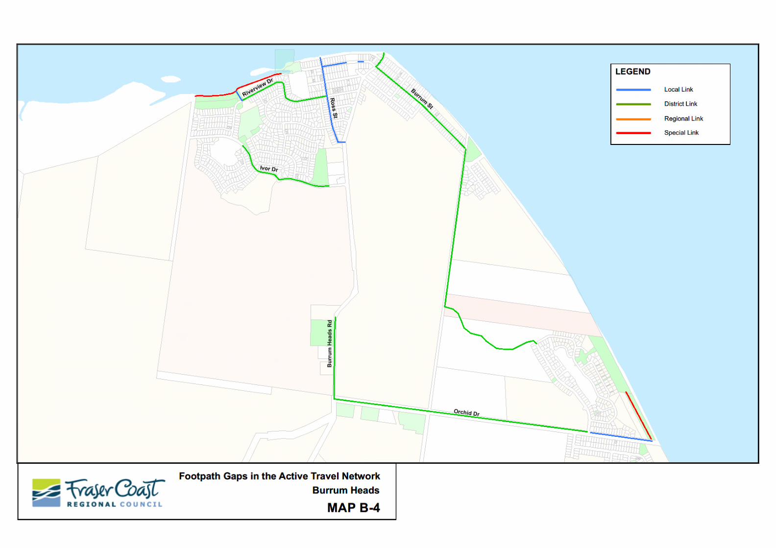


Table of Footpath Network Gaps
Greater than 200m
Less than 200m
Appendix C
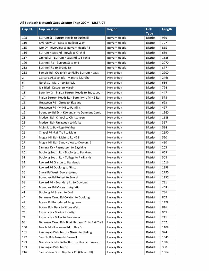
All Footpath Network Gaps Greater Than 200m - DISTRICT
Gap ID Gap Location Region Link Type
Length
108 Burrum St - Burrum Heads to Bushnell Burrum Heads District 939
110 Riverview Dr - Ross to Bulleen Way Burrum Heads District 797
115 Ivor Dr - Riverview to Burrum Heads Rd Burrum Heads District 815
116 Burrum Heads Rd - Bowls to Orchid Burrum Heads District 639
117 Orchid Dr - Burrum Heads Rd to Sirenia Burrum Heads District 1885
120 Bushnell Rd - Burrum St to end Burrum Heads District 2070
212 Bushnell Rd to Sirenia Dr Burrum Heads District 877
218 Sempfs Rd - Craignish to Pialba Burrum Heads Hervey Bay District 2200
2 Corser St/Esplanade - Mant to Murphy Hervey Bay District 2466
6 North St - Martin to Banksia Hervey Bay District 686
7 Ibis Blvd - Kestrel to Martin Hervey Bay District 724
13 Serenity Dr - Pialba Burrum Heads to Endeavour Hervey Bay District 447
14 Pialba Burrum Heads Rd - Serenity to M-HB Rd Hervey Bay District 578
15 Urraween Rd - Citrus to Blaxland Hervey Bay District 623
15 Urraween Rd - M-HB to Pantlins Hervey Bay District 427
16 Boundary Rd Ext - Kawungan to Denmans Camp Hervey Bay District 1960
21 Madsen Rd - Chapel to Christensen Hervey Bay District 1583
23 Madsen Rd - Urraween to Maike Hervey Bay District 317
24 Main St to Bayridge Heights Hervey Bay District 514
26 Chapel Rd -Rail Trail to Main Hervey Bay District 2690
27 Maggs Hill Rd - Main to Rd 478 Hervey Bay District 550
27 Maggs Hill Rd - Sandy View to Doolong S Hervey Bay District 450
29 Samarai Dr - Rasmussen to Bayridge Hervey Bay District 203
30 Doolong South Rd - Doolong to Parakeet Hervey Bay District 668
31 Doolong South Rd - College to Parklands Hervey Bay District 508
33 Raward Rd Gilston to Parklands Hervey Bay District 1016
34 Raward Rd Doolong to Gilston Hervey Bay District 1198
36 Shore Rd West Booral to end Hervey Bay District 2790
37 Boundary Rd Robert to Booral Hervey Bay District 1357
38 Raward Rd - Boundary Rd to Doolong Hervey Bay District 731
40 Boundary Rd Maree to Aquatic Hervey Bay District 408
41 Doolong Rd Bream to Cod Hervey Bay District 756
44 Denmans Camp Rd Colyton to Doolong Hervey Bay District 809
49 Booral Rd Boundary-Ellengowan Hervey Bay District 1479
50 Booral Rd - Beck to Shore West Hervey Bay District 816
73 Esplanade - Marine to Jetty Hervey Bay District 965
74 Esplanade - Miller to Buccaneer Hervey Bay District 211
98 Denmans Camp Rd - Boat Harbour Dr to Rail Trail Hervey Bay District 262
100 Beach Rd -Urraween Rd to Bay Dr Hervey Bay District 1408
101 Kawungan Distributor - Nissen to Stirling Hervey Bay District 974
192 Sempfs Rd- Anson to Sawmill Hervey Bay District 1841
193 Grinsteads Rd - Pialba Burrum Heads to Anson Hervey Bay District 1382
193 Kawungan Distributor Hervey Bay District 380
216 Sandy View Dr to Bay Park Rd (Ghost Hill) Hervey Bay District 1664
All Footpath Network Gaps Greater Than 200m – DISTRICT cont.
Gap ID Gap Location Region Link Type
Length
121 William St - Philip to Alice Howard and Torbanlea District 283
125 Burgowan Rd - Torbanlea to Government Howard and Torbanlea District 2637
126 Torbanlea Pialba Rd - Burgowan to Rd 687 Howard and Torbanlea District 215
64 Cambridge St - Blackbourne to Bushnell Maryborough District 625
137 Pallas St - Saltwater Creek to Woodstock Maryborough District 1061
142 Woodstock St - Neptune St to Bryant Maryborough District 280
144 Woodstock St - Pallas to Thurecht Maryborough District 585
147 Luptin Park - Boys to Walker Maryborough District 400
155 Lennox St - Ann to Queen Maryborough District 201
158 Queen St - Morning to Russell Maryborough District 460
159 Kent St - Pallas to Russell Maryborough District 1700
160 Russell St - Allice to Edward Maryborough District 231
161 Russell St - Kent to Walker Maryborough District 462
162 Walker St - Searle to Bruce Hwy Maryborough District 1689
164 Pallas St - Walker to Churchill Maryborough District 409
168 Maryborough Biggenden Rd - Royale to Nagel Maryborough District 969
170 Iindah Rd East - Gympie to Madison Maryborough District 1609
201 Fort St - South to Alice Maryborough District 888
202 South St - Ferry to Fort Maryborough District 212
229 Russell St -Alice to Queen Maryborough District 439
60 River Heads Road - Bengston to Carrington River Heads District 1383
All Footpath Network Gaps Greater Than 200m – REGIONAL
Gap ID Gap Location Region Link Type Length
17 Pialba Burrum Heads Rd - Ansons to Drury Hervey Bay Regional 3344
19 Maryborough Hervey Bay Rd - PB Heads to south Hervey Bay Regional 13649
51 Booral Rd - Shore West River Heads Rd Hervey Bay Regional 2084
53 Bruce Highway - William to Gympie Howard and Torbanlea Regional 4805
133 Cambridge St - Bushnell to east Maryborough Regional 1670
205 Eatonvale Rd - Gympie to Bruce Hwy Maryborough Regional 2826
206 Central Rd - Gympie to Bruce Hwy Maryborough Regional 1721
52 River Heads Rd - Booral to Bengston River Heads Regional 7387
All Footpath Network Gaps Greater Than 200m – SPECIAL
Gap ID Gap Location Region Link Type Length
104 Burrum Heads Esplanade Burrum Heads Special 705
211 South Esplanade Burrum Heads Special 416
72 Pulgul Creek Route - Hood to Elizabeth Hervey Bay Special 1655
176 Serenity Dr - Imperial to existing Hervey Bay Special 1153
222 Gatakers Bay -Mant to Mant Hervey Bay Special 2466
228 Marineview bypass Queens Rd to Denman Camp Hervey Bay Special 380
207 Maria St - William to Steley St Howard and Torbanlea Special 479
All Footpath Network Gaps Greater Than 200m – LOCAL
Gap ID Gap Location Region Link Type Length
119 Orchid Dr - Sirenia to South Esplanade Burrum Heads Local 437
220 Ross St - Burrum Hds Rd to Esplanade Burrum Heads Local 730
1 Corser St/Esplanade - Esplanade to Murphy Hervey Bay Local 589
3 Barker St - Mant to Corser Hervey Bay Local 717
9 Corfield St - North to Belleni Hervey Bay Local 217
10 Corfield St - Marr to Esplanade Hervey Bay Local 356
20 Christensen St - Rail Trail to Main Hervey Bay Local 1999
35 Gilston Rd - Doolong to existing Hervey Bay Local 600
42 Squire St Doolong to Snapper Hervey Bay Local 555
43 Gilston Rd Doolong to south Hervey Bay Local 717
45 Doolong Rd - Denmans Camp to Raward Hervey Bay Local 770
47 Rosewood Ave - Sandalwood to Doolong Hervey Bay Local 670
75 Pulgul St - Boat Harbour to Jennylee Hervey Bay Local 215
80 Boat Harbour Dr - Mylne to Lavell Hervey Bay Local 1478
82 Howard St - Boat Harbour to Garden Hervey Bay Local 335
86 Boat Harbour Dr - Bideford to Tavistock Hervey Bay Local 429
87 Boat Harbour Dr - Denmans Camp to Dartmouth Hervey Bay Local 1134
88 Boat Harbour Dr - Franklin to Fairway Hervey Bay Local 681
90 Fairway Dr - M-HB Rd to end Hervey Bay Local 440
92 Oleander Ave - Shelly to Banksia Hervey Bay Local 562
95 Mackay Dr - Royal to Gallery Hervey Bay Local 443
97 Richard Charles Dr - Urraween Rd to Mackay Hervey Bay Local 265
102 Conservation Dr - Satinwood to Pantlins Hervey Bay Local 403
103 Scrub Hill Rd - Urraween to Empire Hervey Bay Local 817
180 King St - Rail Trail to Kent Hervey Bay Local 392
183 Tina Drive - Ronaldo to Padre Hervey Bay Local 267
184 Haydn Way - Main to Kawungan Hervey Bay Local 201
187 Rd 912 - Springs to Rail Trail Hervey Bay Local 678
188 Springs Estate Madsen to Main Hervey Bay Local 1664
189 Hudson Dr - Christensen to existing Hervey Bay Local 534
213 Walkers Rd to John Duigan Hervey Bay Local 1144
217 Richard Charles Dr - Main St to existing Hervey Bay Local 792
223 Dover St - Tooth to Beach Hervey Bay Local 790
224 Pantlins Ln - School to Conservation Hervey Bay Local 260
225 Royal Dr - Mackay to Davis Hervey Bay Local 236
227 Boat Harbour Dr - Detour (Baird to Maheno) Hervey Bay Local 450
226 Boat Harbour Dr - Detour (Baird to Banksia Park) Hervey Bay Local 250
123 William St - Whitley to Dimantina Howard and Torbanlea Local 460
130 Gympie St - Bruce Hwy to Burgowan Howard and Torbanlea Local 591
232 Hoffman St - Arnaund to Cambridge Maryborough Local 215
233 Arnaund St - Cardigan St to Hoffman Maryborough Local 430
131 Cardigan St - Maryborough-Cooloola to Burns Maryborough Local 1028
132 Banana St - Wolseley to Hoffman Maryborough Local 1506
134 Smith St - Aubinville to Booker Maryborough Local 495

All Footpath Network Gaps Greater Than 200m – LOCAL cont.
Gap ID Gap Location Region Link Type Length
138 Victory St - Neptune to Pallas Maryborough Local 1000
139 Neptune St = Boys to Victory Maryborough Local 850
140 Neptune St - Winston Noble to Boys Maryborough Local 321
145 Bryant St - Woodstock to End Maryborough Local 870
148 March St - Albert to Queen Maryborough Local 438
150 Richmond St - Albert to Ann Maryborough Local 203
153 Ann St - Ferry to March Maryborough Local 571
154 Ann St - Ferry to Cheapside Maryborough Local 1240
163 Albert St - Ferry to Lennox Maryborough Local 524
165 Royale St - Maryborough Biggenden to Rd 410 Maryborough Local 267
169 Woongool Rd - Gympie to Nerada Maryborough Local 2164
171 Teddington Rd - Gympie to Iindah Maryborough Local 1866
175 Walworth St - Gympie to Tulipwood Maryborough Local 222
194 Sydney St - Saltwater Creek to Ariadne Maryborough Local 433
195 Ariadne St - Victory to Churchill Maryborough Local 1087
196 Churchill St - Ariadne to Cheapside Maryborough Local 420
197 Yaralla St - Walker to Churchill Maryborough Local 449
199 Cheapside St - Alice to Rail Trail Maryborough Local 232
203 Wolseley St - Banana to Arnaud Maryborough Local 443
62 McIvor St - Holmes to Ferris Ave River Heads Local 588
63 Ferris Ave McIvor to Fraser Dr River Heads Local 565
64 Kingfisher Dr - Fraser to Bengston Rd River Heads Local 835
65 Sandpiper St - Kingfisher to River Heads River Heads Local 371
66 Bengtson Rd - Kingfisher to River Heads River Heads Local 580
67 Seafarer Dr - Cove to Park River Heads Local 576
68 Cove Blvd - River Heads to Bengston River Heads Local 2287
70 Heritage Otlk - Windjammer to Woongoolbver River Heads Local 500
71 Woongoolbver Ct - Heritage to End River Heads Local 301

All Footpath Network Gaps Less Than 200m - DISTRICT
Gap ID Gap Location Region Link Type Length
221 Burrum Heads Rd - Burrum St to Esplanade Burrum Heads District 126
22 Madsen Rd - Christensen Hervey Bay District 114
39 Boundary Rd Denmans Camp to Maree Hervey Bay District 110
177 Dougan St - Corser to Sealink Hervey Bay District 151
143 Woodstock St - Neptune to existing Maryborough District 84
All Footpath Network Gaps Less Than 200m - LOCAL
Gap ID Gap Location Region Link Type Length
106 Burrum St - Ross to east Burrum Heads Local 184
107 Burrum St - Shops Burrum Heads Local 37
111 Riverview Dr - link to North Esplanade Burrum Heads Local 90
219 Sawmill Rd - PBH Rd to Sempfs Hervey bay Local 170
8 Corfield St - Mant to Spence Hervey Bay Local 159
25 Main St - Christensen to Haydn Hervey Bay Local 74
46 Doolong Rd - Raward to Rosewood Hervey Bay Local 90
48 Sandalwood Dr - Ronaldo to Rosewood Hervey Bay Local 81
76 Pulgul St - Dayman Park Hervey Bay Local 110
77 Pulgul St - Dayman Park to Esplanade Hervey Bay Local 45
78 Miller St - Arthur to Smith Hervey Bay Local 112
79 Miller St - Elizabeth to Rail Trail Hervey Bay Local 152
81 Garden Dr - Howard to existing Hervey Bay Local 28
91 McLiver St - Tenimby - Baird Hervey Bay Local 119
96 Mackay Dr - Richard Charles to Westminster Hervey Bay Local 122
181 Kent St - Kin to Pulgul Hervey Bay Local 197
182 Moolyyir St - Esplanade to existing Hervey Bay Local 137
191 Augustus Way - Scrub Hill to existing Hervey Bay Local 54
230 Banksia St - North to Murphy Hervey bay Local 140
122 Steley St- Coal to Martha Howard and Torbanlea Local 107
231 Dau Dr - Cambridge to School Maryborough Local 130
141 Neptune St - Aberdeen to Winston Noble Maryborough Local 163
151 Adelaide Lne - Ann to existing Maryborough Local 92
152 Adelaide Lne - Albert to existing Maryborough Local 47
198 Winston Noble Dr - Churchill to existing Maryborough Local 100
200 Cheapside St - Kent St to Rail Trail Maryborough Local 84
204 Arnaud St - Wolseley to Raglan Maryborough Local 157
61 Holme St - River Heads to McIvor River Heads Local 194
69 Windjammer Cct - Cove to Heritage River Heads Local 124