For more news from all the IMOS Facilities check the IMOS...
12
marinematters 1 IMOS issue eight May 2010 For the first time a weather buoy has been deployed in the remote Southern Ocean, moored in water 4.6km deep, 580km southwest of Tasmania at 46.75S, 142E. The IMOS Southern Ocean Flux Station (SOFS) was deployed from the Marine National Facility research vessel Southern Surveyor on the 17th of March, and has been relaying back to shore hourly observations of the wind, temperature, humidity, air pressure, sunlight and rain. The data provides insight into the current conditions “down south” as well as helping to build a record in this climatically important region of the world ocean. The real time data plots are available on the IMOS Ocean Portal. The $1M SOFS buoy took 12 months to build in the USA by the Woods Hole Oceanographic Institution, and is operated by the Bureau of Meteorology as part of the Australian Bluewater Observing System Facility. As well as aiding weather forecasting, the meteorological observations are used to compute the total heat, mass and momentum fluxes on time scales from diurnal up to annual. While the Southern Ocean plays a significant role in the global climate system, there is a paucity of sustained in situ air-sea flux observations in this harsh and remote region. The high quality observations are a valuable contribution to building the climate record and understanding climate variability. On the same voyage the first Seaglider was successfully launched at the Southern Ocean Time Series (SOTS) site and the pulse mooring was recovered. The Seaglider is one of 17 in the Australian National Facility for Ocean Gliders fleet, with this new route funded by the EIF enhancement to IMOS. The Seaglider is travelling well and currently making its way towards Tasmania. > For more news from all the IMOS Facilities check the IMOS website imos.org.au/news.html IMOS News IMOS deploys the world’s first weather buoy in the remote Southern Ocean The SOFS buoy in the rough conditions of the Southern Ocean. Loading the SOFS buoy onto the Marine National Facility Southern Surveyor Photo: Rob Wiltshire Photo: Eric Schulz
Transcript of For more news from all the IMOS Facilities check the IMOS...

marinematters 1
IMOSissue eight May 2010
For the first time a weather buoy
has been deployed in the remote
Southern Ocean, moored in water
4.6km deep, 580km southwest
of Tasmania at 46.75S, 142E.
The IMOS Southern Ocean Flux Station (SOFS) was deployed from the Marine National Facility research vessel Southern Surveyor on the 17th of March, and has been relaying back to shore hourly observations of the wind, temperature, humidity, air pressure, sunlight and rain. The data provides insight into the current conditions “down south” as well as helping to build a record in this climatically important region of the world ocean. The real time data plots are available on the IMOS Ocean Portal. The $1M SOFS buoy took 12 months to build in the USA by the Woods Hole Oceanographic Institution, and is operated by the Bureau of Meteorology as part of the Australian Bluewater Observing System Facility.
As well as aiding weather forecasting, the meteorological observations are used to compute the total heat, mass and momentum fluxes on time scales from diurnal up to annual. While the Southern Ocean plays a significant role in the global climate system, there is a paucity of sustained in situ air-sea flux observations in this harsh and remote region. The high quality observations are a valuable contribution to building the climate record and understanding climate variability.
On the same voyage the first Seaglider was successfully launched at the Southern Ocean Time Series (SOTS) site and the pulse mooring was recovered. The Seaglider is one of 17 in the Australian National Facility for Ocean Gliders fleet, with this new route funded by the EIF enhancement to IMOS. The Seaglider is travelling well and currently making its way towards Tasmania.
> For more news from all the IMOS Facilities check the IMOS website imos.org.au/news.htmlIMOS News
IMOS deploys the world’s first weather buoy in the remote Southern Ocean
The SOFS buoy in the rough conditions of the Southern Ocean.
Loading the SOFS buoy onto the Marine National Facility Southern Surveyor
Pho
to: R
ob W
iltsh
ireP
hoto
: Eric
Sch
ulz
2 marinematters
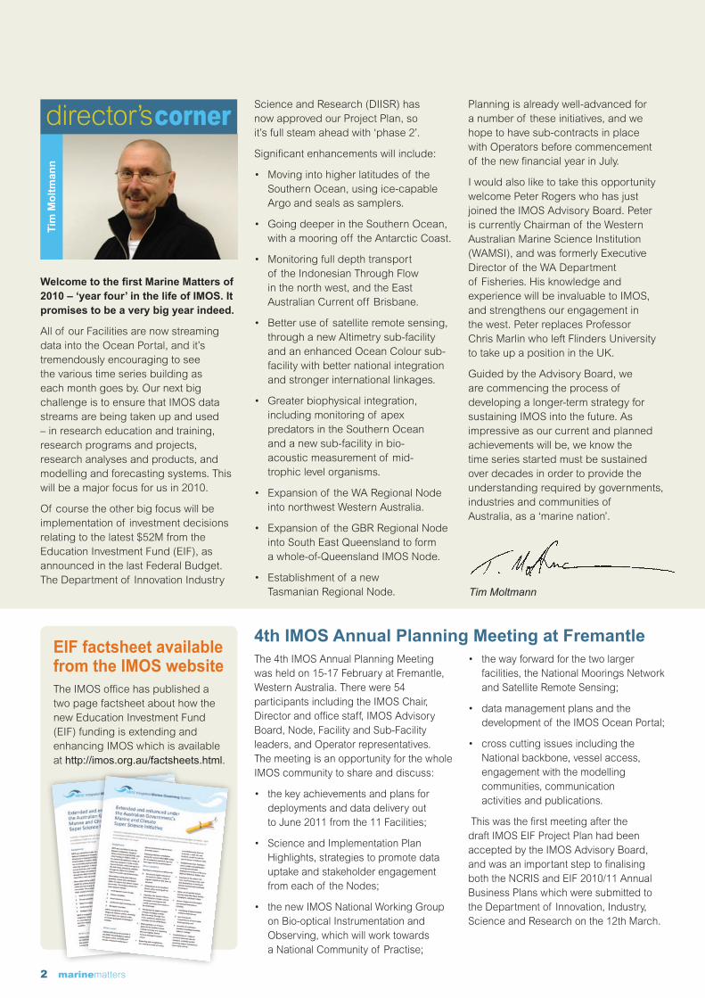
Welcome to the first Marine Matters of 2010 – ‘year four’ in the life of IMOS. It promises to be a very big year indeed.
All of our Facilities are now streaming data into the Ocean Portal, and it’s tremendously encouraging to see the various time series building as each month goes by. Our next big challenge is to ensure that IMOS data streams are being taken up and used – in research education and training, research programs and projects, research analyses and products, and modelling and forecasting systems. This will be a major focus for us in 2010.
Of course the other big focus will be implementation of investment decisions relating to the latest $52M from the Education Investment Fund (EIF), as announced in the last Federal Budget. The Department of Innovation Industry
Science and Research (DIISR) has now approved our Project Plan, so it’s full steam ahead with ‘phase 2’.
Significant enhancements will include:
• Movingintohigherlatitudesof theSouthern Ocean, using ice-capable Argo and seals as samplers.
• GoingdeeperintheSouthernOcean,with a mooring off the Antarctic Coast.
• Monitoringfulldepthtransportof the Indonesian Through Flow in the north west, and the East Australian Current off Brisbane.
• Betteruseof satelliteremotesensing,through a new Altimetry sub-facility and an enhanced Ocean Colour sub-facility with better national integration and stronger international linkages.
• Greaterbiophysicalintegration,including monitoring of apex predators in the Southern Ocean and a new sub-facility in bio-acoustic measurement of mid-trophic level organisms.
• Expansionof theWARegionalNodeinto northwest Western Australia.
• Expansionof theGBRRegionalNodeinto South East Queensland to form a whole-of-Queensland IMOS Node.
• Establishmentof anewTasmanian Regional Node.
Planning is already well-advanced for a number of these initiatives, and we hope to have sub-contracts in place with Operators before commencement of the new financial year in July.
I would also like to take this opportunity welcome Peter Rogers who has just joined the IMOS Advisory Board. Peter is currently Chairman of the Western Australian Marine Science Institution (WAMSI), and was formerly Executive Director of the WA Department of Fisheries. His knowledge and experience will be invaluable to IMOS, and strengthens our engagement in the west. Peter replaces Professor Chris Marlin who left Flinders University to take up a position in the UK.
Guided by the Advisory Board, we are commencing the process of developing a longer-term strategy for sustaining IMOS into the future. As impressive as our current and planned achievements will be, we know the time series started must be sustained over decades in order to provide the understanding required by governments, industries and communities of Australia, as a ‘marine nation’.
Tim
Mo
ltm
ann
Tim Moltmann
EIF factsheet available from the IMOS websiteThe IMOS office has published a two page factsheet about how the new Education Investment Fund (EIF) funding is extending and enhancing IMOS which is available at http://imos.org.au/factsheets.html.
The 4th IMOS Annual Planning Meeting was held on 15-17 February at Fremantle, Western Australia. There were 54 participants including the IMOS Chair, Director and office staff, IMOS Advisory Board, Node, Facility and Sub-Facility leaders, and Operator representatives. The meeting is an opportunity for the whole IMOS community to share and discuss:
• thekeyachievementsandplansfordeployments and data delivery out to June 2011 from the 11 Facilities;
• ScienceandImplementationPlanHighlights, strategies to promote data uptake and stakeholder engagement from each of the Nodes;
• thenewIMOSNationalWorkingGroupon Bio-optical Instrumentation and Observing, which will work towards a National Community of Practise;
• thewayforwardforthetwolargerfacilities, the National Moorings Network and Satellite Remote Sensing;
• datamanagementplansandthedevelopment of the IMOS Ocean Portal;
• crosscuttingissuesincludingtheNational backbone, vessel access, engagement with the modelling communities, communication activities and publications.
This was the first meeting after the draft IMOS EIF Project Plan had been accepted by the IMOS Advisory Board, and was an important step to finalising both the NCRIS and EIF 2010/11 Annual Business Plans which were submitted to the Department of Innovation, Industry, Science and Research on the 12th March.
4th IMOS Annual Planning Meeting at Fremantle

marinematters 3
The Australian Animal Tagging
and Monitoring System (AATAMS)
Facility recently deployed the first
of 15 conductivity, temperature
and depth (CTD) tags on an adult
female elephant seal at Macquarie
Island, by a team lead by Dr Iain
Field from Macquarie University.
The CTD tags were funded as part of the Education Investment Fund (EIF) enhancement to IMOS. The data from the tags will be used in a collaborative research programme between leading researchers Prof Rob Harcourt, from Macquarie University, and Prof Mark Hindell from the University of Tasmania. It is clear that over the past decade that Antarctica and the surrounding Southern Ocean is changing at an unprecedented rate due to climate change. This is likely to have profound consequences for both the ecosystem and the environment, which strongly influences the climate in Australia. Yet precise measures of these changes and how animals respond to them has proven extremely difficult to measure. Over the course of the Antarctic summer, 30 seals have been equipped with these CTD tags, from the sub-Antarctic Macquarie Island and Casey Station in Antarctica to observe ecosystem level and physical ocean interactions.
Southern elephant seals are large predators that forage in the Southern Ocean covering a wide geographical range. They are major consumers of biomass and are likely to be affected
AATAMS successfully deploys the first CTD tag on a seal at Macquarie Is
by variation in food availability. Over summer the seals return from the sea for their annual moult and then return to the Southern Ocean for their eight month long winter foraging migration. As some of the seals undertake this migration this year they will carry a miniaturised tracking and CTD unit to observe their foraging behaviour and observe the ocean around them. The CTD tag will record where in the ocean the seal is, what it has been doing, and what the ocean temperature and water conductivity is along its path. This is the first year of a new long term monitoring program that will provide sustained observations of the Southern Ocean. Even after only one day at sea, the first seal was over 70 km from Macquarie Island and
already diving to 700 m and providing diving and environmental profiles.
This data enables both biologists and oceanographers to learn from the seals to gain a much better understanding of how the environment influences the seals foraging behaviour and success, directly in relation to differences in the ocean around them. It also simultaneously provides data that can be used in ocean and climate models. The oceanographic data would otherwise be very expensive and extremely challenging to collect. With this new method of collecting integrated data IMOS will enable researchers to determine the big changes in the Southern Ocean and the influences they may have on the fragile ecosystem.
Patrick Gorringe has recently joined the electronic Marine Information Infrastructure (eMII) team as a Deputy Director. Pat comes from Sweden where, following a masters degree in physical oceanography at Stockholm University, he joined Sweden’s Meteorological and Hydrological Institute in 2002. His early work focused on circulation and algal bloom forecast modelling for the Baltic Sea before, in 2004, joining the EuroGOOS Office, the responsible body for coordinating Operational Oceanography in Europe. Pat comes
to us with a unique competence of operational oceanography and its applications, its users and ocean policy issues within Europe and at a global level. With in-depth skills in international marine data management through participation in a number of projects, initiatives and workgroups in Europe and links to similar activities around the globe, Pat will focus on coordinating real-time data in IMOS and drawing together the diverse marine datasets which will contribute to the Australian Ocean Data Network. Welcome Pat!
eMII welcomes new Deputy Director Patrick Gorringe
Mr Pat Gorringe
Pho
to: C
hris
Oos
thui
zen
4 marinematters
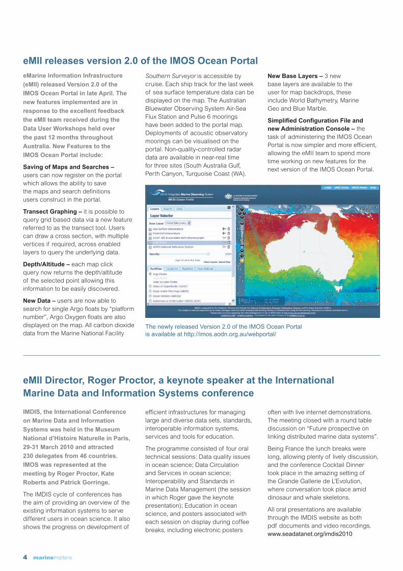
eMarine Information Infrastructure
(eMII) released Version 2.0 of the
IMOS Ocean Portal in late April. The
new features implemented are in
response to the excellent feedback
the eMII team received during the
Data User Workshops held over
the past 12 months throughout
Australia. New Features to the
IMOS Ocean Portal include:
Saving of Maps and Searches – users can now register on the portal which allows the ability to save the maps and search definitions users construct in the portal.
Transect Graphing – it is possible to query grid based data via a new feature referred to as the transect tool. Users can draw a cross section, with multiple vertices if required, across enabled layers to query the underlying data.
Depth/Altitude – each map click query now returns the depth/altitude of the selected point allowing this information to be easily discovered.
New Data – users are now able to search for single Argo floats by “platform number”, Argo Oxygen floats are also displayed on the map. All carbon dioxide data from the Marine National Facility
Southern Surveyor is accessible by cruise. Each ship track for the last week of sea surface temperature data can be displayed on the map. The Australian Bluewater Observing System Air-Sea Flux Station and Pulse 6 moorings have been added to the portal map. Deployments of acoustic observatory moorings can be visualised on the portal. Non-quality-controlled radar data are available in near-real time for three sites (South Australia Gulf, Perth Canyon, Turquoise Coast (WA).
New Base Layers – 3 new base layers are available to the user for map backdrops, these include World Bathymetry, Marine Geo and Blue Marble.
Simplified Configuration File and new Administration Console – the task of administering the IMOS Ocean Portal is now simpler and more efficient, allowing the eMII team to spend more time working on new features for the next version of the IMOS Ocean Portal.
eMII releases version 2.0 of the IMOS Ocean Portal
IMDIS, the International Conference
on Marine Data and Information
Systems was held in the Museum
National d’Histoire Naturelle in Paris,
29-31 March 2010 and attracted
230 delegates from 46 countries.
IMOS was represented at the
meeting by Roger Proctor, Kate
Roberts and Patrick Gorringe.
The IMDIS cycle of conferences has the aim of providing an overview of the existing information systems to serve different users in ocean science. It also shows the progress on development of
efficient infrastructures for managing large and diverse data sets, standards, interoperable information systems, services and tools for education.
The programme consisted of four oral technical sessions: Data quality issues in ocean science; Data Circulation and Services in ocean science; Interoperability and Standards in Marine Data Management (the session in which Roger gave the keynote presentation); Education in ocean science, and posters associated with each session on display during coffee breaks, including electronic posters
often with live internet demonstrations. The meeting closed with a round table discussion on “Future prospective on linking distributed marine data systems”.
Being France the lunch breaks were long, allowing plenty of lively discussion, and the conference Cocktail Dinner took place in the amazing setting of the Grande Gallerie de L’Evolution, where conversation took place amid dinosaur and whale skeletons.
All oral presentations are available through the IMDIS website as both pdf documents and video recordings. www.seadatanet.org/imdis2010
The newly released Version 2.0 of the IMOS Ocean Portal is available at http://imos.aodn.org.au/webportal/
eMII Director, Roger Proctor, a keynote speaker at the International Marine Data and Information Systems conference
marinematters 5
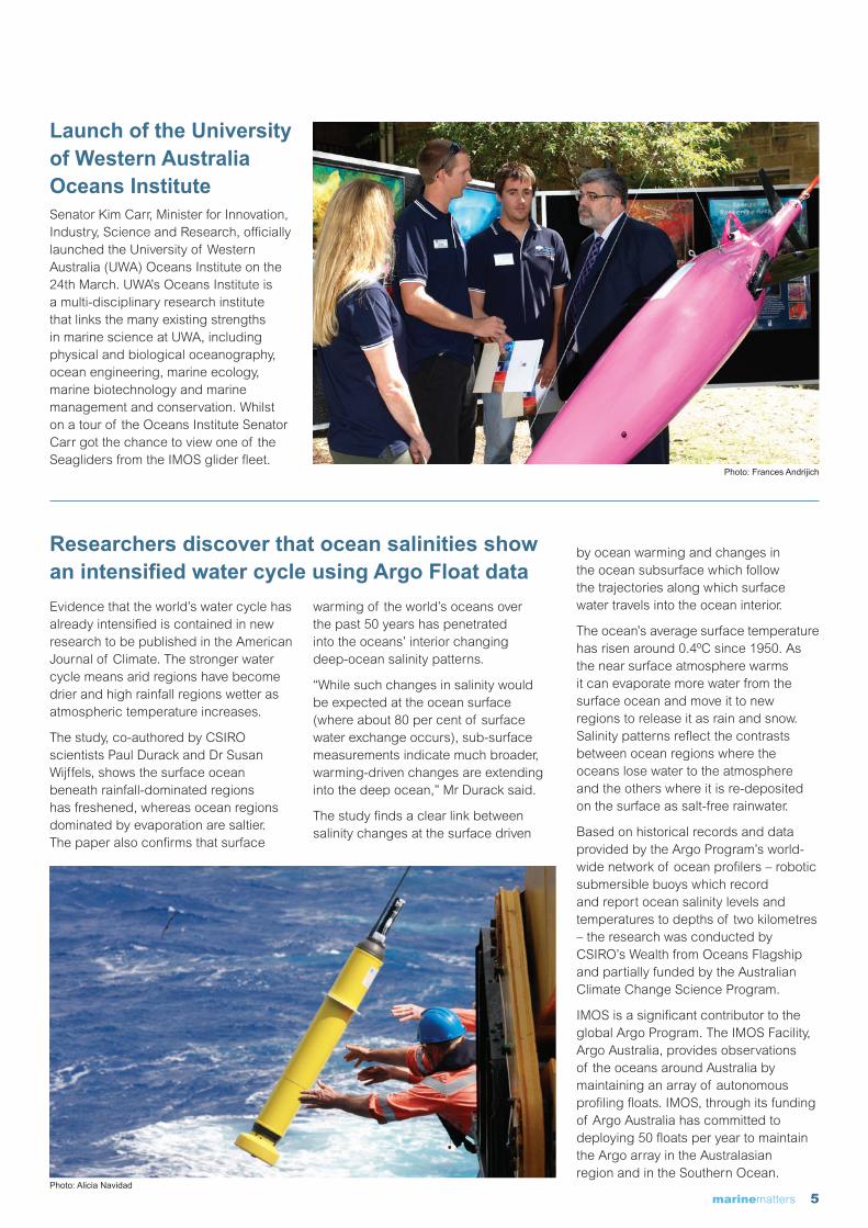
Launch of the University of Western Australia Oceans Institute Senator Kim Carr, Minister for Innovation, Industry, Science and Research, officially launched the University of Western Australia (UWA) Oceans Institute on the 24th March. UWA’s Oceans Institute is a multi-disciplinary research institute that links the many existing strengths in marine science at UWA, including physical and biological oceanography, ocean engineering, marine ecology, marine biotechnology and marine management and conservation. Whilst on a tour of the Oceans Institute Senator Carr got the chance to view one of the Seagliders from the IMOS glider fleet.
Photo: Frances Andrijich
Evidence that the world’s water cycle has already intensified is contained in new research to be published in the American Journal of Climate. The stronger water cycle means arid regions have become drier and high rainfall regions wetter as atmospheric temperature increases.
The study, co-authored by CSIRO scientists Paul Durack and Dr Susan Wijffels, shows the surface ocean beneath rainfall-dominated regions has freshened, whereas ocean regions dominated by evaporation are saltier. The paper also confirms that surface
warming of the world’s oceans over the past 50 years has penetrated into the oceans’ interior changing deep-ocean salinity patterns.
“While such changes in salinity would be expected at the ocean surface (where about 80 per cent of surface water exchange occurs), sub-surface measurements indicate much broader, warming-driven changes are extending into the deep ocean,” Mr Durack said.
The study finds a clear link between salinity changes at the surface driven
by ocean warming and changes in the ocean subsurface which follow the trajectories along which surface water travels into the ocean interior.
The ocean’s average surface temperature has risen around 0.4ºC since 1950. As the near surface atmosphere warms it can evaporate more water from the surface ocean and move it to new regions to release it as rain and snow. Salinity patterns reflect the contrasts between ocean regions where the oceans lose water to the atmosphere and the others where it is re-deposited on the surface as salt-free rainwater.
Based on historical records and data provided by the Argo Program’s world-wide network of ocean profilers – robotic submersible buoys which record and report ocean salinity levels and temperatures to depths of two kilometres – the research was conducted by CSIRO’s Wealth from Oceans Flagship and partially funded by the Australian Climate Change Science Program.
IMOS is a significant contributor to the global Argo Program. The IMOS Facility, Argo Australia, provides observations of the oceans around Australia by maintaining an array of autonomous profiling floats. IMOS, through its funding of Argo Australia has committed to deploying 50 floats per year to maintain the Argo array in the Australasian region and in the Southern Ocean.
Researchers discover that ocean salinities show an intensified water cycle using Argo Float data
Photo: Alicia Navidad

6 marinematters
Prince William views IMOS gear during his trip to AustraliaHis Royal Highness Prince William of Wales KG visited CSIRO aboard the Marine National Facility Southern Surveyor in Sydney on his recent Australian tour. Whilst CSIRO scientist Dr Steve Rintoul provided Prince William with a five-minute overview of CSIRO’s climate and ocean-climate research, which relies heavily on observations made using high-tech robotic vehicles from IMOS, including an Argo Float, an Ocean glider and the Autonomous Underwater Vehicle. Steve Rintoul highlighted how they play a vital role in understanding climate change, associated sea-level rise, and ocean acidification. During his ship visit, Prince William, was also able to view samples of marine life such as coral, deep-sea fish, crustaceans and sea stars from the Australian Museum and CSIRO. The Marine National Facility is supported by the Australian Government.
Dr Edward King – new Satellite Remote Sensing (SRS) Facility Leader
Dr Rudy Kloser – new Ships of Opportunity Sub-Facility leader for Bio-acoustics
Dr Bernadette Sloyan – new Australian Bluewater Observing System (ABOS) Sub-Facility Leader for Deepwater Arrays
Dr Chris Watson – new SRS sub-facility leader for Satellite Altimetry
Mr Laurent Besnard – new eMII project officer
Mr Pat Gorringe – new eMII Assistant Director for Science Engagement – see news story on page 3
Dr Peter Thompson – new Tasmanian Integrated Marine Observing System Node Leader
New faces in IMOSThe IMOS office would like to welcome the following new Facility, Sub-Facility and Node
Leaders and eMarine Information Infrastructure (eMII) staff members.
There has also been a Node Leadership change for the Southern Australian Integrated Marine Observing System (SAIMOS) Node, Dr Laurent Seuront has stepped down as SAIMOS Node Leader to act as Deputy Node Leader (Strategic). Dr John Middleton will take up the position as SAIMOS Node Leader, with Dr Sophie Laterme acting as Deputy Node Leader (Operational).
Dr Edward King Dr Bernadette Sloyan Dr Chris Watson Mr Laurent Besnard
Prince William views an ocean glider, an Argo float and the AUV. Photo by: Belinda Mason, Courtesy of: CSIRO

marinematters 7
SAIMOS Node team win a SARDI Achievement Award
John Middleton and the Oceanography Group were recently presented with the award for “Services to SARDI” at a South Australian Research and Development Institute (SARDI) Achievement Awards ceremony by Affiliate Professor Rob Lewis, Executive Director of SARDI and member of the IMOS Advisory Committee.
The award was in recognition “for establishing the Southern Australian Integrated Marine Observing System (SAIMOS), one of the coastal nodes of the national Integrated Marine Observing System (IMOS), to provide new insights into the role of oceans on climate, ecosystems and seafood production. In less than three years the oceanography program has created an impressive research capability, now undertaking fundamental research used to guide fisheries management, the selection of aquaculture sites, inform the establishment of marine parks, and quantify the impacts of desalination plants, sewerage outfalls and potential biosecurity risks.”
IMOS data to be used in the recently awarded Super Science Fellowships Congratulations to the successful IMOS affiliated organisations who have received Australian Government funding for Super Science Fellowships recently. The Super Science Fellowships provide support for early-career researchers to work in areas of national significance, one of which is marine and climate science. Fifty three-year Super Science Fellowships will be funded to start in 2010 and another fifty fellowships in 2011. The Australian Institute of Marine Science received funding for six fellows over two projects that both study the effect of a changing climate on the Great Barrier Reef. The University of Sydney received one fellow who will use data from the Autonomous Underwater Vehicle Facility to observe and model marine benthic habitats. The University of Tasmania received two fellows who will examine the effects of climate change on temperate benthic assemblages on the continental shelf in eastern Australia. The Australian Antarctic Division received funding for two fellows to study pelagic ecosystem linkages in the changing Southern Ocean. These Super Science Fellowships will use data from IMOS Facilities, building on the infrastructure investment in marine and climate science.
The Autonomous Underwater Vehicle (AUV) was launched off Rottnest Island recently to survey kelp forests on reefs at four locations from Cape Naturaliste to the Abrolhos Islands, in the first stage of a long-term observation study of the ecology of Australia’s sea-floor.
The study is being conducted using the IMOS AUV, by the CSIRO Wealth from Oceans Flagship and The University of Western Australia Oceans Institute (UWA OI) – as a collaboration through the Western Australian Marine Science Institution (WAMSI) – to
increase understanding of how ocean currents affect coastal ecosystems.
“A focus of the study will be on how kelp forests influence biodiversity and productivity by generating food for valuable resources such as fisheries,” CSIRO research scientist Dr Mat Vanderklift said. “Our observations will enable us to monitor and adapt to processes such as changes to major currents or climate change.”
“The AUV was used to survey kelp forests on reefs at three locations from Rottnest Island to the Abrolhos Islands,” UWA’s Professor Gary Kendrick said.
“Using an AUV we can produce detailed maps and do repeated surveys of the sea-floor allowing us to see how habitats change from year to year.”
Although the AUV has undertaken numerous exploratory missions around Australia over the past few years, this is one of the largest such studies attempted worldwide. The annual surveys, funded as part of the EIF extension and enhancement to IMOS, will take place off the coasts of Queensland, New South Wales, Tasmania and Western Australia. All the data from these AUV surveys will be available through the IMOS Ocean Portal.
Nationwide sea-floor ecology study starts off in WA using the AUV
The SARDI Oceanography Group with Rob Lewis: Carlos Teixeira, Rick McGarvey, Rob Lewis, Louise Renfrey, John Middleton, Shaun Byrnes, Charles James, and Mark Doubell.
8 marinematters
Facility Feature Article #8
Facility for Automated Intelligent Monitoring of Marine Systems (FAIMMS)
– wireless sensor networks monitoring the Great Barrier Reef
Australia’s iconic Great Barrier Reef (GBR) is the largest coral reef system
in the world, composed of over 2,900 individual reefs and 900 islands that
extend across a distance of 2,300 kilometres. This unique reef ecosystem
supports a rich diversity of marine life and was selected as a World Heritage
Site in 1981. Whilst the effects of tourist activities and fishing are carefully
managed, the GBR is under pressure from a range of threats including
terrestrial run off and climate change. Predictions are that storms and coral
bleaching events will increase in frequency and severity with rising sea
temperatures. The ocean is also becoming more acidic due to increased
absorption of CO2 from the atmosphere; which may reduce the growth of corals
as they struggle to build their skeletons. IMOS is deploying wireless sensor
networks at seven sites along the GBR through the Facility for Automated
Intelligent Monitoring of Marine Systems (FAIMMS) to provide the real time
data to monitor how the reef is coping with an ever changing environment.
Townsville
Cairns
Mackay
QUEENSLAND
Rockhampton
CORAL SEA
Heron Island
One Tree Island
Orpheus Island
Davies Reef
Rib Reef
Myrmidon Reef
Lizard Island
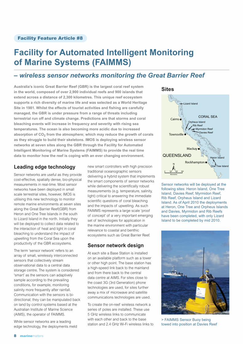
Sensor networks will be deployed at the following sites: Heron Island, One Tree Island, Davies Reef, Myrmidon Reef, Rib Reef, Orpheus Island and Lizard Island. As of April 2010 the deployments at Heron, One Tree and Orpheus Islands and Davies, Myrmidon and Rib Reefs have been completed, with only Lizard Island to be completed by mid 2010.
> FAIMMS Sensor Buoy being towed into position at Davies Reef
Leading edge technologySensor networks are useful as they provide cost-effective, spatially dense, bio-physical measurements in real-time. Most sensor networks have been deployed in small scale terrestrial sites, however, IMOS is utilising this new technology to monitor remote marine environments at seven sites along the Great Barrier Reef(GBR) from Heron and One Tree Islands in the south to Lizard Island in the north. Initially they will be deployed to collect data related to the interaction of heat and light in coral bleaching to understand the impact of upwelling from the Coral Sea upon the productivity of the GBR ecosystems.
The term ‘sensor network’ refers to an array of small, wirelessly interconnected sensors that collectively stream observational data to a central data storage centre. The system is considered ‘smart’ as the sensors can adaptively sample according to the prevailing conditions, for example, monitoring salinity more frequently after rainfall. Communication with the sensors is bi-directional; they can be manipulated back on land by control systems based at the Australian Institute of Marine Science (AIMS), the operator of FAIMMS.
While sensor networks are a leading edge technology, the deployments meld
new smart controllers with high precision traditional oceanographic sensors delivering a hybrid system that implements the smart components of sensor networks while delivering the scientifically robust measurements (e.g. temperature, salinity, light) critical to answering the immediate scientific questions of coral bleaching and the impacts of upwelling. As such FAIMMS represents a large scale ‘proof of concept’ of a very important emerging set of technologies for application in the marine environment with particular relevance to coastal and benthic ecosystems such as Great Barrier Reef.
Sensor network designAt each site a Base Station is installed on an available platform such as a tower or other high point. The base station has a high-speed link back to the mainland and from there back to the central data centre at AIMS. For sites close to the coast 3G (3rd Generation) phone technologies are used, for sites further away a mix of microwave and satellite communications technologies are used.
To create the on-reef wireless network a series of poles are installed. These use 5 GHz wireless links to communicate with each other and back to the base station and 2.4 GHz Wi-Fi wireless links to
Sites

marinematters 9
create the on-reef wireless network. This on-water reef network is compatible with any computer based wireless networking card, delivering internet access and capacity to the reef on the reef itself.
Finally, buoys are moored around the reef near to coral and other areas of interest. The sensors are mounted off the buoys, a smart controller collects the data from the sensors and transmits it to the nearest network pole and then back to the base station and then back to AIMS and onto the IMOS Ocean Portal. One of the poles also has a weather station to collect on-water meteorological data.
Wireless sensor network dataInitially the buoys and poles that make up the matrix of the networks will be deployed with sensors that measure salinity, water depth (as pressure), vertical profiles of water temperature and above water light and meteorological parameters. The resulting data is collected every 10 minutes giving high definition measurements from a range of locations and depths. This data is provided freely and openly through the IMOS Ocean Portal (http://imos.aodn.org.au/webportal/). Data from the One Tree Island sensor network
Schematic Diagram of the Sensor Network at Heron Island
FAIMMS base station on Orpheus Island FAIMMS Sensor Pole at Orpheus Island

10 marinematters
illustrates the impact of Cyclone Hamish as it tore through the region in March 2009.
The cyclone also proved the durability of the sensor network, as local winds reached almost 100km/hr.
How to ‘plug and play’IMOS is providing the infrastructure on the GBR to enable scientists and students to undertake a broader range of reef observational studies and research projects. The basic concept is a ‘plug and play’ network for compliant sensors to be embedded in the reception area. During 2010-11 the systems will be upgraded to 802.11 compliant networks allowing any wireless computing device to interface to the network delivering both the internet to the reef and, as importantly, the ability to remotely operate and monitor reef based instruments. Applications include remote video, remote monitoring of instruments and sensors, deployment of sensors on the FAIMMS buoys and towers and provision of mobile sensors for collecting real time environmental data to compliment other experimental work. If you would like to use the sensor networks on the GBR for your research please contact the Facility Leader, Scott Bainbridge.
Future DevelopmentsFAIMMS is already providing its serviced based data into Pachube (www.pachube.com). Pachube is a web service that enables you to store, share and discover real time sensor, energy and environment data from objects, devices and buildings around the world. By providing the data via Pachube it then allows other services to use the data as a feed into further applications and end products. For example an iPhone Application is available to view the real time FAIMMS data from the Pachube system.
CollaborationThe FAIMMS Facility is operated by the Australian Institute of Marine Science (AIMS) on behalf of a number of partners. The Island Research Stations are each part of the Topical Marine Network which is a joint educational
Date
Bar
omte
ric P
ress
ure
(HP
a)
998
1000
1002
1004
1006
1008
1010
1012
1014
010
20
30
40
50
60
70
80
90
Max
imum
Win
d S
peed
(kp
h)
25.0
25.5
26.0
26.5
27.0
27.5
30.0
29.5
29.0
28.5
28.0
Wat
er T
empe
ratu
re (
Deg
. C.)
Sensor data from One Tree Island for cyclone Hamish
Stratified Water Column
Well Mixed Water Column
2-Mar-2009 6-Mar-2009 10-Mar-2009Date
14-Mar-2009 18-Mar-2009
Sensor data from One Tree Island for Cyclone Hamish. Barometric pressure (top graph) drops, wind speed (middle graph) rises and the water column that had exhibited marked stratification (bottom graph, red line is surface temperature, blue line is the middle of the water column, green line is bottom temperature) became well mixed.
program of the University of Sydney (One Tree Island), University of Queensland (Heron Island), James Cook University (Orpheus Island) and the Australian Museum (Lizard Island). Other partners to FAIMMS include the Queensland Cyber Infrastructure Foundation (QCIF) and the University of Melbourne through the ARC Research Network on Intelligent Sensors, Sensor Networks and Information Processing (ISSNIP). FAIMMS is co-funded by the Queensland State Government. FAIMMS is also linked with a number of International Programs including the Coral Reef Ecological Observatory Network (CREON), the Data Turbine Open Source Software Project at the San Diego Supercomputer Center, and the International Long Term Ecological Research (ILTER) project in Moorea, French Polynesia, run out the University of California Santa Barbra.
SummaryFAIMMS has provided the Australian Integrated Marine Observing System (IMOS) with a testing bed for some new approaches to real time ‘smart’ systems using traditional oceanographic equipment, plug and play technologies, shallow water applications, real time data management systems and real time communications. The wireless sensor networks set up by FAIMMS along the GBR will provide the data that researchers and environmental managers need to monitor changes in the reef. The network infrastructure also offers researchers an unprecedented resource in developing and deploying new sensors and experimental systems to help preserve this environmentally and economically important Australian icon.
For more information please contactScott Bainbridge – FAIMMS Facility LeaderEmail: [email protected]
All photos and figures courtesy of AIMS.

marinematters 11
IMOS Data Visualisation
Data from 7 sea lions tagged with CTD tags (see news story on page 2) as part of the EIF extension and enhancement to IMOS. This image, courtesy of Simon Goldsworthy, illustrates the location of over 7,000 CTD profiles collected over the eastern Great Australian Bight between November 2009 and May 2010 by the sea lions. The image shows temperature depth profiles with 12-20 degree temperature range (deep blue to dark red).
With Ocean Radar data coming on line in WA, the Western Australia IMOS (WAIMOS) Science Node is beginning to explore the power of combining the data from gliders, radar and Sea Surface Temperature (SST). This image, courtesy of Ben Hollings and Chari Pattiaratchi, shows the proposed glider track along the Two Rocks Transect in relation to the concurrent SST and the High Frequency Radar surface currents.
12 marinematters
Director Mr Tim [email protected]
Executive OfficerMrs Jo [email protected]
Project Officer Dr Marian McGowen [email protected]
Scientific OfficerDr Katy [email protected]
Office AssistantMs Virginia [email protected]
Technical DirectorMr Simon [email protected]
For more information about IMOS please visit the website www.imos.org.auGeneral enquiries: IntegratedMarineObservingSystem(IMOS),Universityof Tasmania,PrivateBag110,Hobart,TAS,7001•+61(03)62267505T•+61(03)62262107F
Facility Leaders:
Argo AustraliaDr Susan Wijffels [email protected]
Enhanced Measurements from Ships of Opportuniity (SOOP)Mr Ken [email protected]
Australian Bluewater Observing System (ABOS) Dr Tom [email protected]
Australian National Facility for Ocean Gliders (ANFOG) Prof Charitha [email protected]
Autonomous Underwater Vehicle Facility (AUV) Dr Stefan [email protected]
Australian National Mooring NetworkDr Tim [email protected]
Australian Coastal Ocean Radar Network (ACORN) Prof Mal [email protected]
Australian Animal Tagging and Monitoring System (AATAMS) Dr Rob [email protected]
Facility for Automated Intelligent Monitoring of Marine Systems (FAIMMS) Mr Scott [email protected]
eMarine Information Infrastructure (eMII)Dr Roger [email protected]
Satellite Remote Sensing (SRS)Dr Edward [email protected]
Node Leaders:
Blue water and climateMr Ken [email protected]
Queensland’s IMOS (Q-IMOS) Dr Peter [email protected]
New South Wales IMOS (NSW-IMOS)Prof Iain [email protected]
Southern Australian IMOS (SAIMOS)Dr John [email protected]
Western Australia IMOS (WAIMOS) Prof Charitha [email protected]
Tasmanian IMOS (TasIMOS) Dr Peter [email protected]
IMOS is supported by the Australian Government through the National Collaborative Research Infrastructure Strategy and the Super Science Initiative. It is led by the University of Tasmania on behalf of the Australian marine and climate science community.
This issue of marine matters has been compiled by
Dr Marian McGowen. Thanks to Louise Renfrey, Andrew
Boomer, Roger Proctor, Kylie Pepper, Craig Macaulay,
Sarah Wood and Meg Rive for providing news items.
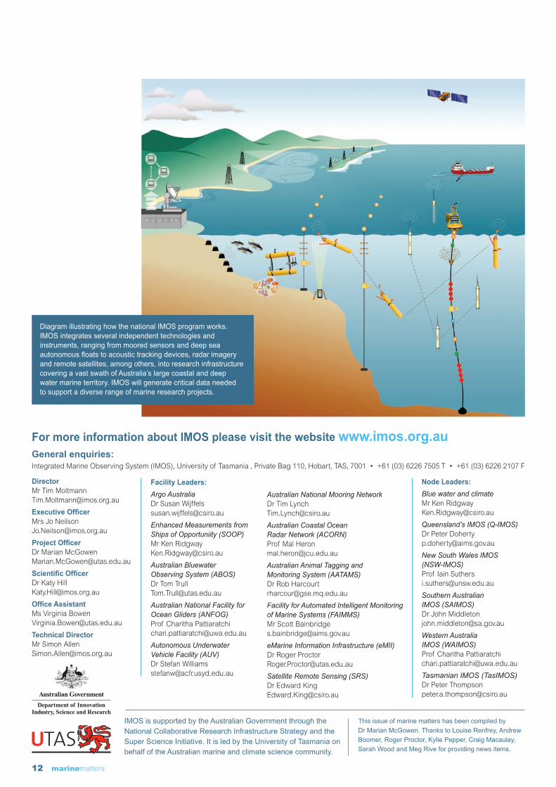
Diagram illustrating how the national IMOS program works. IMOS integrates several independent technologies and instruments, ranging from moored sensors and deep sea autonomous floats to acoustic tracking devices, radar imagery and remote satellites, among others, into research infrastructure covering a vast swath of Australia’s large coastal and deep water marine territory. IMOS will generate critical data needed to support a diverse range of marine research projects.