NSW-IMOS Node Science and Implementation Plan (NSIP) July...
85
i NSW-IMOS Node Science and Implementation Plan (NSIP) July 2009-June 2013 NSW-IMOS: An Integrated Marine Observing System for south-eastern Australia The East Australian Current, its separation from the coast and its interaction with coastal ecosystems IMOS Node: New South Wales - Integrated Marine Observing System Lead Institution: Sydney Institute of Marine Science (SIMS) Co-Node Leaders: Prof. Iain Suthers, SIMS/UNSW, 02 9385 2065/8987 9924; [email protected] Dr. Moninya Roughan, SIMS/UNSW, 02 9385 7067; [email protected] Deputy Node Leader: Dr Martina Doblin, SIM/UTS, 02 9514 8307 [email protected] Collaborating Institutions: University of New South Wales; Macquarie University; University of Sydney; University of Technology Sydney; NSW Department of Environment, Climate Change & Water (DECCW); NSW Department of Service Technology and Administration; NSW Department of Industry and Investment; Sydney Water Corporation. Date 30 August 2010; file NSW-IMOS-NSIP-Aug10-v10.doc Prepared by Moninya Roughan, Iain Suthers, Bradley Morris, Leanne Armand, Mark Baird, Andrew Boomer, David Booth, Gary Brassington, Maria Byrne, Doug Cato, Melinda Coleman, Ed Couriel, Bob Creese, Martina Doblin, Will Figueira, Bill Gladstone, Rob Harcourt, Katy Hill, Neil Holbrook, Rob McCauley, Tim Pritchard, Peter Ralph, Anthony Richardson, Robin Robertson, Tracey Rogers, Milton Speer, Peter Steinberg, Matthew Taylor, Hua Wang, Stefan Williams and others. SIMS Contribution #: XXXX Wednesday, 1 September 2010
Transcript of NSW-IMOS Node Science and Implementation Plan (NSIP) July...

i
NSW-IMOS Node Science and Implementation Plan (NSIP) July 2009-June 2013
NSW-IMOS: An Integrated Marine Observing System
for south-eastern Australia
The East Australian Current, its separation from the coast and its interaction
with coastal ecosystems
IMOS Node: New South Wales - Integrated Marine Observing System
Lead Institution: Sydney Institute of Marine Science (SIMS)
Co-Node Leaders: Prof. Iain Suthers, SIMS/UNSW, 02 9385 2065/8987 9924; [email protected]
Dr. Moninya Roughan, SIMS/UNSW, 02 9385 7067;
Deputy Node Leader:
Dr Martina Doblin, SIM/UTS, 02 9514 8307 [email protected]
Collaborating Institutions:
University of New South Wales; Macquarie University; University of
Sydney; University of Technology Sydney; NSW Department of
Environment, Climate Change & Water (DECCW); NSW Department of
Service Technology and Administration; NSW Department of Industry and Investment; Sydney Water Corporation.
Date 30 August 2010; file NSW-IMOS-NSIP-Aug10-v10.doc
Prepared by Moninya Roughan, Iain Suthers, Bradley Morris, Leanne Armand, Mark Baird,
Andrew Boomer, David Booth, Gary Brassington, Maria Byrne, Doug Cato, Melinda Coleman,
Ed Couriel, Bob Creese, Martina Doblin, Will Figueira, Bill Gladstone, Rob Harcourt, Katy Hill,
Neil Holbrook, Rob McCauley, Tim Pritchard, Peter Ralph, Anthony Richardson, Robin
Robertson, Tracey Rogers, Milton Speer, Peter Steinberg, Matthew Taylor, Hua Wang, Stefan
Williams and others.
SIMS Contribution #: XXXX Wednesday, 1 September 2010

ii
Summary
The marine environment on the narrow continental shelf along the coast of NSW is dominated by
the poleward flowing East Australian Current (EAC) and the eddy field it produces. The EAC
sporadically stimulates upwelling and transports the resulting phytoplankton blooms and marine
larvae south along the coast or into the Tasman Sea. Depending on the configuration of the eddy
field, the EAC can transport waters poleward to Tasmania, or east toward New Zealand. Due to
its broad geographical reach, the EAC influences the climate and marine economies of nearly half
the Australian population, from Brisbane to Sydney, Hobart and Melbourne.
The poleward extension of the EAC is strengthening, shown by an increase of over 2ºC per
century at the Maria Island reference station off eastern Tasmania. The water temperature regime
has therefore been shifted ~350 km southwards. The EAC, and its changing nature, will impact
the climate and weather of NSW, as well as the state‟s ecological and socio-economic values.
The natural variability of the EAC, driven largely by the mescoscale eddy field, makes it difficult
to forecast, and even hindcast, Tasman Sea currents. Much of the variability has its origin in the
separation dynamics of the EAC off central New South Wales, and the subsequent formation of
warm and cold core eddies. To focus on this behaviour, more observations of currents around the
separation zone are required. The vertical distribution of bio-physical properties is essential to
understand the implications of what has mostly been interpreted from remote sensing. The EAC
eddy field has been related to the sudden overnight intensification of East Coast Lows (ECLs)
and severe winter storms. In June 2007 five ECLs led to 10 deaths, the grounding of a ship,
severe flooding and coastal erosion. ECLs are also responsible for 10-20% of coastal rainfall and
substantial filling of our reservoirs. Our focus on processes north and south of the separation
zone off Coffs Harbour (30ºS) and Sydney (34ºS) is complemented by similar observations off
Eden (37ºS), off Hobart by Tas-IMOS (43.5ºS), and by the full depth monitoring of the EAC off
Stradbroke Island by Q-IMOS (28ºS). These observations parallel those made for the poleward
Leeuwin Current, to understand common ENSO and SOI phenomena and other teleconnections.
For example northward propagating coastally trapped waves are driven by storms in Bass Strait
and the Great Australian Bight, contributing up to 50% of the current variability off Sydney.
Biological observing is increasingly important as we begin to understand the implications of the
strengthening and variable EAC. Biological outcomes underlie most of the socioeconomic drivers
or ecosystem properties relevant to ocean observing in general. For example, offshore fishing
permits are now managed by water mass properties (SST), rather than static latitudinal rules.
Warming, combined with urbanization, has been linked to fundamental changes in pelagic and
temperate reef ecosystems, particularly to the demise of kelp and changes in the distribution of
sea urchins along the coast of southeastern Australia. We will use both water column and deep
reef observing to monitor changes in these fundamental marine primary producers and
“ecosystem engineers”. The effect of different water masses and eddies of the EAC on
phytoplankton (pigments) and zooplankton diversity/abundance must be quantified, as these
organisms underlie all ocean food webs.
Other ecosystem impacts will also be tracked through observations of benthic habitats, fish
behaviour and by monitoring animal vocalisations, in relation to oceanographic signals. For
example, in late summer 2009, 3 separate shark attacks occurred in Sydney Harbour or
neighbouring beaches – the first for the region in nearly 50 years. At the time Sydney
experienced heat-wave conditions, associated with strong upwelling favourable NE winds, and
unusually cool water temperatures along the coast.

iii
The key research aims pertinent to NSW-IMOS are:
1) To contribute to national observations of decadal changes and climate variability of the
EAC, Leeuwin, and Flinders Currents using common platforms and metrics.
i) To determine the variability in EAC strength from its source in the Coral Sea, the
seasonal and spatial variability in the separation of the EAC from central NSW, and the
EAC‟s southward extension;
ii) Contribute to monitoring the Bass Strait outflow and the northward coastally trapped
wave propagation;
iii) Contribute to the national backbone through the National Reference Station network
and the supplementation of Satellite Remote Sensing products with local data.
2) To investigate the EAC, its separation from the coast, and the resultant eddy field along
the coast of SE Australia.
i) To determine the frequency, form and function (horizontal and vertical) of EAC
eddies;
ii) To understand air sea interactions, particularly to determine the development of East
Coast Lows and severe winter storms in relation to warm core eddies;
iii) Quantify the impact of key physical processes such as onshore encroachment of the
EAC, slope water intrusions, upwelling, downwelling and internal waves.
3) To quantify oceanographic processes on the continental shelf and slope of SE Australia: i) Examine the coastal wind and wave climate in driving nearshore currents and the
northward sediment transport;
ii) Quantify the biogeochemical cycling of carbon (nutrients and phytoplankton
composition);
iii) Determine the transport and dispersal of passive particles (e.g. larvae, eggs, spores)
and the degree of along coast connectivity and trophic linkages.
4) To integrate the ecosystem response with oceanographic processes:
i) Quantify the daily to decadal variation of planktonic communities in relation to
oceanographic and climate-driven changes in physical and chemical ocean properties;
ii) Quantify rocky reef biota variables (kelp distribution and abundance) associated with
climate variability, at deep reefs along the NSW to Tasmanian coast;
iii) Relationship of the EAC, its eddies and oceanographic conditions on fisheries, and
movements by fish and sharks;
iv) Quantify the seasonal and yearly variation of upper-predator (fish and marine
mammal) communities.
We are addressing these aims by the following essential observations:
Maintaining an array of oceanographic moorings north and south of the separation zone:
2 moorings off Coffs Harbour (30ºS), 4 moorings off Sydney (34ºS), and 2 moorings off
southern NSW (Batemans Bay/Eden-37ºS), measuring temperature, salinity, dissolved
oxygen and velocity; some augmented with bio-optical sensors (turbidity, chlorophyll-a
fluorometer) to support autonomous ocean glider deployments and Satellite Remote
Sensing;
Continued monthly biogeochemical sampling along the National Reference Transect
(Port Hacking, near the Sydney Mooring array) for determination of phytoplankton and
pigment diversity and concentration, zooplankton abundance and diversity, suspended
particulate matter, and concentration of colour dissolved organic matter for bio-optical

iv
sensor calibration to interpret Satellite Remote Sensing products and to maintain one of
three of the longest ocean time-series in Australia;
Deployment of a high frequency coastal radar (WERA) off Coffs Harbour (30ºS) which
will provide surface current velocities, and when combined with the data from the
waverider buoy network will provide important information regarding the wave climate
along the coast of NSW;
The deployment of autonomous ocean gliders with bio-optical sensors to make repeat
transects across the NSW shelf and into EAC eddies, and to fill-in observations where
ARGO is unable to sample;
Sustained observing of fish and shark migration using shore-normal arrays of acoustic
receivers off Sydney and Coffs Harbour, in collaboration with our industry partners‟
receivers;
Using Satellite Remote Sensing, the Continuous Plankton Recorder (CPR-SOOP) as
well as bio-acoustic measurements to examine latitudinal variations in zooplankton and
phytoplankton species composition;
Undertaking sustained observations of benthic habitats, especially kelp distributions using
an autonomous underwater vehicle (AUV) to measure changes in deep water reef biota
in response to predicted changes in the EAC;
Deploying passive-acoustic moorings to provide information on biological community
change, and multiple species (e.g. fish, mammals, turtles etc), which will be useful to
monitor long-term changes in community composition.
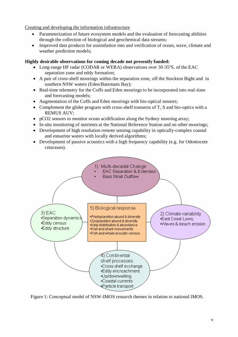
The expected outputs from NSW-IMOS with respect to national IMOS priorities (Fig. 1):
Providing a national backbone for observing boundary currents
Continued development of ocean circulation models particularly over the continental shelf
region, ranging from hindcasting, nowcasting and forecasting;
Enhanced models of biophysical coupling through enhanced measurement of mechanistic
parameters driving biological variability (e.g. light) and via mapping of biological
parameters onto the physical variability of the EAC;
Increasing the accuracy of spatially broad, synoptic satellite remote sensing products such
as ocean colour, phytoplankton productivity, and particle concentration;
Continuing to build institutional strengths into national capability
Training of multi-disciplinary post graduate students in quantitative ecology,
geomorphology, oceanography and meteorology;
Building IT and instrumentation skills and ocean mooring capability within SIMS and the
NSW community;
Communicating IMOS outputs to the community, and especially informing K-12 students
and educators about the East Australian Current.
Exploring the potential for whole-of-system approaches
Understanding of latitudinal, seasonal and annual patterns in plankton diversity off the
continental shelf;
Understanding of cross-shelf flows, deep water intrusions and the impact they have on
diversity and abundance of lower trophic levels;
Linking up-stream (Q-IMOS) and down-stream (Tas-IMOS) observations of the EAC for
understanding oceanographic and biological impacts of upstream changes in the strength
of the EAC;
Improved predictions of fish landings based on rainfall and oceanographic variation.
Driving down the cost per observation
Validating contemporary Satellite Remote Sensing derived estimates of chlorophyll-a,
primary productivity, and particle concentration against direct IMOS observations;
v
Creating and developing the information infrastructure
Parameterization of future ecosystem models and the evaluation of forecasting abilities
through the collection of biological and geochemical data streams;
Improved data products for assimilation into and verification of ocean, wave, climate and
weather prediction models;
Highly desirable observations for coming decade not presently funded:
Long-range HF radar (CODAR or WERA) observations over 30-35ºS, of the EAC
separation zone and eddy formation;
A pair of cross-shelf moorings within the separation zone, off the Stockton Bight and in
southern NSW waters (Eden/Batemans Bay);
Real-time telemetry for the Coffs and Eden moorings to be incorporated into real-time
and forecasting models;
Augmentation of the Coffs and Eden moorings with bio-optical sensors;
Complement the glider program with cross-shelf transects of T, S and bio-optics with a
REMUS AUV;
pCO2 sensors to monitor ocean acidification along the Sydney mooring array;
In-situ monitoring of nutrients at the National Reference Station and on other moorings;
Development of high resolution remote sensing capability in optically-complex coastal
and estuarine waters with locally derived algorithms;
Development of passive acoustics with a high frequency capability (e.g. for Odontocete
cetaceans).
Figure 1: Conceptual model of NSW-IMOS research themes in relation to national IMOS.
6
List of Contents
Summary 2
1. Socio-Economic Context 8
2. Scientific Background
a) The East Australian Current -a current of eddies 13
b) Continental Shelf Processes 15
c) Research Questions 23
d) National context of NSW-IMOS within a national IMOS 24
3. Pre-existing observations
3-1) pre-IMOS 26
3-2) Existing IMOS 2007-2009 and justification of on-going need 28
4. Observations needed
4-1) During 2009-2013 and beyond (Table of priorities) 35
4-2) Addressing the Research Questions (Summary table) 42
5. NSW-IMOS Implementation Plan July 2007-June2013
a) Ocean Moorings (ANMN) 54
b) Passive Acoustics (ANMN) 54
c) Coastal Radar (ACORN) 55
d) Ocean Gliders (ANFOG) 57
e) Underwater Vehicle (AUV) 57
f) Animal Tracking (AATAMS) 58
6. Use of IMOS data 59
7. Impact of IMOS observations regionally, nationally, globally 65
8. Governance, structure and funding 67
9. References 70
Appendix 1. List of NSW-IMOS members 76
Appendix 2. List of honours, post-grad students and post-docs using IMOS data 78
Appendix 3. Future IMOS goals and infrastructure:
a. Long range coastal radar at the separation zone 30-35ºS 80
b. REMUS autonomous underwater vehicle 81
Appendix 4. Guidelines for Prioritisation of Infrastructure Needs (K. Hill) 83
Appendix 5. Deep Sea Research II Special Issue 84

7
Acronym list:
ANMN Australian National Mooring Network facility of IMOS
ACORN Australian Coastal Ocean Radar Network facility of IMOS
ADFA Australian Defence Force Academy-UNSW
AIMS Australian Institute of Marine Science
ANFOG Australian National Facility for Ocean Gliders facility of IMOS
ARC Australian Research Council
AUV Autonomous Underwater Vehicle facility of IMOS
AATAMS Australian Animal Tracking and Monitoring System facility of IMOS
CSIRO Commonwealth Scientific and Industry Research Organisation
CMAR CSIRO Marine and Atmospheric Research
DECCW NSW Department of Environment, Climate Change & Water
DMS Defence Maritime Services
DIISR Commonwealth Department of Innovation, Industry Science and Research
DSTO Defence Science & Technology Organisation
EIF Education Investment Fund (the second funding source for IMOS, 2009-2013)
eMII Electronic Marine Information Infrastructure facility of IMOS
GBR Great Barrier Reef
II NSW NSW Dept. of Industry & Investment (formerly DPI, Dept. Primary Industries)
LJCO Lucinda Jetty Colour Observatory (Queensland)
MACU Macquarie University
MHL Manly Hydraulics Laboratory (NSW Department of Commerce)
NCRIS National Collaborative Research Infrastructure Scheme (the initial funding source for IMOS 2006-2011, sometimes referred to as IMOS-1)
NSIP Node Science & Implementation Plan
OFS Oceanographic Field Services
ORS Ocean Reference Station (3 km off Sydney in 65 m)
SARDI South Australian Research & Development Institute
SIMS Sydney Institute of Marine Science
SRS Satellite Remote Sensing facility of IMOS
UNSW University of New South Wales
UTS University of Technology, Sydney
USYD University of Sydney
WAMSI West Australian Institute of Marine Science
WQM Water Quality Meter
WRL UNSW Water Research Laboratory

8
1. Socio-economic context
Introduction
Most of Australia‟s urban population is located on the narrow eastern and southern seaboards
(Fig. 2), making the associated coastal waters among the nation's most exploited and often
stressed environments. More than 80% of Australians are located within 50 km of the coast and
more than half the nation lives within the coastal fringe from Brisbane to Melbourne (Fig. 2).
The major problems for this coastline are urbanization, water quality, freshwater supply, severe
storms and beach erosion.
Perth
0 500
kilometres
1000
Adelaide
Melbourne
Brisbane
Sydney
Figure 2: Australia and its continental shelf in light brown (200 m isobath), illustrating the
particularly narrow shelf and proximity of the EAC off New South Wales (Figure
modified from GeoScience Australia).
Climate Change
Future climate change will have wide ranging effects on the coastal and marine environment of
NSW. The East Australian Current (EAC) is predicted to both strengthen and warm significantly
which will have many diverse effects from changing weather patterns to shifts in marine species
distribution. There is also predicted to be an increase in storm frequency and intensity which
will cause significant changes in rainfall patterns and the wave climate potentially resulting in
greater beach erosion, storm surge and coastal inundation. Species range shifting as a response
to these and other climate change effects will have impacts for biodiversity, invasive species and
fisheries. The most dramatic changes are being observed on the Tasmanian coastline, with the
demise of native kelp (Macrocystis pyrifera) due to the southern range extension by the sea
urchin Centrostephanus rogersii (Ling et al. 2009).
Water
The coastline of NSW alone has over 450 coastal discharge sites along the NSW coast, the
largest three being off Sydney amounting to nearly 1000 ML.d-1
. Phytoplankton blooms (red
tides) were of intense concern in relation to Sydney‟s deep water sewage outfalls, but were
linked to oceanographic events such as those at the EAC separation zone (Dela-Cruz et al.

9
2003). Declining rainfall has resulted in Sydney‟s storage being as low as 33% capacity and
other major centres (Goulburn) to much lower capacities resulting in closure of local business
and temporary re-location of the Police Academy. A desalination plant is now operational in
Sydney (Kurnell) as part of the plan to address the water shortage in Metropolitan Sydney (up to
250 ML d-1
).
Storm events – East Coast Lows
In recent years severe storm events generated by East Coast Lows (ECLs), have caused
fatalities, severe flooding (e.g. Newcastle and northern NSW) and erosion and caused hazards
for shipping (e.g. the Pasha Bulker grounding in June 2007). The severe storms of 1973 and
1974 (Sygna storm) had extreme winds, causing large waves and massive amounts of coastal
erosion (Speer and Leslie 2000). These storms led to the installation of 7 waverider buoys along
the coast of NSW. The storms of Aug. 1986 were implicated in 6 deaths, and produced the worst
flooding in Sydney for over a century (450 mm in 3 days), while the 5 ECL events in June 2007
caused nearly $1000 M in damage and were the cause of 10 deaths. ECLs also provide NSW
with significant amounts of needed rainfall. Some 10-20% of coastal rainfall in NSW is
attributed to ECLs and 66% of high inflow (days > 100 GL) for the Sydney catchments are
attributed to ECLs. Most ECLs occur in winter and are associated with warm SST anomalies
(Hopkins and Holland 1997).
Waves and beaches
Prevailing sand transport along the NSW coast is from south to north. This is in spite of the
prevailing ocean currents (EAC) being from north to south. The sand transport occurs because
of the dominant south-easterly incident direction of the wave climate but the role and rate of
different transport paths is virtually unknown. Changes in the wave climate such as an increase
in wave height, change in the angle of incidence or increased frequency of high magnitude
waves affect the energy at the beach zone and alters sediment transport. Given that the NSW
coast has many substantial shoreline erosion hotspots more monitoring data is essential to give
insight into the role of offshore processes in nearshore beach form, sand volumes and
configuration.
Developing an understanding of the nearshore wave climate is also crucial from the perspective
that remaining stocks of major sand mines around Sydney are close to depletion. The mining of
offshore sand is again receiving consideration in the absence of any substantial field monitoring,
despite the fact that wave direction is known to play an important role in determining nearshore
bed formation.
Marine Tourism
Our largest marine industry is marine tourism, the second largest of all states contributing 22%
of the national marine industry ($27 billion in value added during 2002-03, The Allen Report
2004). The value of the marine industry (i.e. all recreational and light commercial vessels) in
NSW is valued at over $2 billion pa and employs over 11,000 – both figures are almost
equivalent to all other states combined (mostly Victoria and Queensland,
http://www.bia.org.au/data.html). Over a third of the national marine industry employment
(36%) is in NSW – and mostly in marine tourism. These figures are more remarkable
considering that our estuaries, while numerous (>130) are small and we have the nation‟s
narrowest continental shelf (only 20-60 km, Chapman et al. 1982).

10
Fishing
Most of the marine technology industry is related to recreational fishing, which faces significant
problems of declining catch rates. Nearly 20% of the Australian population fish at least once a
year (17% in NSW), and recreational fishers harvest up to 27,000 t of finfish with an annual
value of around $2 billion (Henry and Lyle 2003). Recreational fishing effort increases annually,
sometimes up to 7.5% on the previous year (Gwynne 1994) and this is especially important
around Australia‟s largest and fastest-growing cities on the eastern seaboard. In NSW the
recreational catch is about 30% of the commercial catch, but for 6 major species the recreational
catch is actually greater than the commercial. In NSW the recreational fishing fee bought out
commercial fishing licenses in 25 estuaries in 2001, now described as recreational fishing
havens. Target species that are especially relevant to recreational fishing, tourism and IMOS are
bream, flathead, mulloway, prawns, Australian salmon, grey nurse shark, bullshark and white
shark. The Recreational Fishing Trust is driving research on fish attraction devices (FADS,
moorings up to 20 km offshore), re-stocking projects, and on estuarine artificial reefs. Large
artificial reefs are proposed for the continental shelf off Newcastle, Sydney and Port Kembla
with the main issue being whether these structures are fish-attractors or fish-producers.
NSW managed fisheries‟ main species are oysters (aquaculture), prawns, abalone and sea
mullet. The gross value has declined by around 10% over the past 10 years to around $120 m
(ABARE 2007). This value is about 20% of the national value. The major sectors include
(http://www.fisheries.nsw.gov.au/commercial/eight-fisheries):
Abalone fishery – 48 licence holders, worth around $5 million per annum (m pa);
Estuary General Fishery - the most diverse commercial fishery in NSW with around 700
fishers operating in 102 estuaries along the coast;
Estuary Prawn Trawl Fishery - operates in 3 estuaries harvesting prawns, and in some
estuaries squid and fish;
Lobster fishery - a small trap fishery with 151 licence holders, ~$4.6 m pa
Ocean Hauling Fishery - 3,500 tonnes pa, worth ~ $6 m pa;
Ocean Trawl Fishery - targets prawns ($16 m landed value, 318 licence holders) and
fish (silver trevally, tiger flathead and redfish, 98 licence holders);
Ocean Trap and Line Fishery – a diverse fishery
Commercial fishing is not large in the EMP (East Marine Planning region Fig. 3), valued in
2002-2006 at around $320 m and 1.4% of the national value. These AFMA managed fisheries
(http://www.afma.gov.au/fisheries/default.htm) included the East Coast Deepwater trawl
fisheries, from NSW to LHI (10 concessions, using demersal and midwater trawling); the
Commonwealth Trawl Sector (formerly South East Trawl Fishery), with nearly 60 concessions,
54 vessels using otter trawl and Danish seine methods, some midwater trawling; the Eastern
Tuna and Billfish Fishery (ETBF) with over 100 permits, 72 vessels using pelagic longline,
minor line (handline, troll, rod and reel).
The combination of phytoplankton cycles and blooms with upwelling, EAC strengthening and
sea-surface warming or an increase in ECL‟s, have yet to be investigated against fish
occurrences and stocks. Natural algal food sources for in-situ aquaculture farming also require
observation against increasing sea-surface temperatures and associated shifts in plankton stocks,
cycles and dispersion.

11
Figure 3. The East Marine Planning region (excluding the GBR but including the Coral
Sea and much of the Tasman Sea between the NSW coast to Lord Howe Island). The
colours represent annual average tonnage 2002-2006 recorded by AFMA (i.e.
Commonwealth fisheries beyond 3 nm). Note the distribution is largely restricted to the very narrow, continental shelf (after Moore et al. 2007).
Shark Attacks
In February-March 2009, 3 separate shark attacks occurred in Sydney waters and the first for
nearly 50 years, despite observations of sharks in earlier summers. The presence of sharks in the
harbour surprised the public and resulted in a decline in beach attendance. This period was
distinguished by strong, wind induced upwelling which reduced local water temperatures at the
warmest time of the year from 25ºC to as low as 15ºC. The actual bio-physical relationships and
a risk model for management remain a challenge for NSW-IMOS.
Marine Parks
Marine parks in NSW are located at Cape Byron, Solitary Islands, Lord Howe Island, Jervis
Bay, Port Stephens-Great Lakes and Bateman‟s Bay region, covering ~3,500 km2. The NSW
Marine Parks Authority (MPA) through NSW DECCW aims to establish and manage a system
of multiple-use marine parks designed to conserve marine biodiversity, maintain ecological
processes and provide for ecologically-sustainable use, public appreciation and education of the
marine environment. An important factor requiring consideration during marine park zoning is
the extent of connectivity among populations of the key species, although it is recognised that
this is a feature of marine populations about which we know relatively little. There are still
considerable gaps in our understanding of how the key habitats along the NSW coast are
connected by larval dispersal, whether existing marine park sanctuary zones act as larval
sources, sinks or neither, and how these locations vary seasonally and inter-annually. However,
it is clear that the EAC is a major driver of the spatial and temporal patterns of connectivity.
Information on post-settlement connectivity is also essential to ensure that the location, size and

12
configuration of sanctuary („no-take‟) zones provides adequate protection to mobile species
during different life-history stages.
Marine parks in NSW undergo an extensive review of zoning arrangements approximately every
five years providing a clear mechanism to incorporate information on population connectivity
into the zoning review. To assist with adaptive management of these parks and their zoning a
more thorough understanding of connectivity amongst areas, and the degree of “spill-over” is
required. Moreover, knowledge of how economic and ecologically important benthic habitats
(e.g. kelp forests) are influenced by the EAC and climate will aid in determining marine park
success in achieving its goal of conserving biodiversity.
Shipping
For 2005-2006, ports of the East Marine Planning region (mostly Newcastle, Sydney (Sydney
Harbour and Botany Bay), Brisbane, Port Kembla) accounted for 42% of the nation‟s exports
and 51% of national imports by tonnage (Anon. 2007). These ports accounted for 18% of freight
loaded and 67% unloaded by all Australian ports. The busiest sea lanes are through the Coral
Sea.
Marine Biotechnology
Bioprospecting – the use of naturally derived compounds for the development of drugs or other
products – has a rich history (> 30% of current drugs come from natural sources), and has
obvious socio-economic benefits. The complex oceanography in the NSW region associated
with mixing of the EAC with coastal water and in the generation of eddies suggests a relatively
diverse source of potential microbiological targets for use in medicine and other industries.
Mining
There are no mining activities off NSW, but there is potential for sand mining, manganese
nodule harvesting, or base/precious metals on the Lord Howe Rise. Sand mining has the greatest
potential for NSW in light of beach erosion and construction needs. An EIS for sand mining off
Sydney was conducted during 1990s.
Defence
One of the two major RAN centres is based in Sydney-Garden Island, with additional bases at
Jervis Bay (HMAS Creswell; HMAS Albatross). The RAN‟s primary need from IMOS is
supporting data to improve operational ocean forecasts (BLUElink), especially wave forecasts.
Summary
In summary the common, socio-economic issues of relevance to NSW and IMOS are: the
warming and strengthening of the EAC, severe storm (wind, wave and rainfall) events which
lead to storm surge and beach erosion, marine park planning and kelp distribution, invasive
species, shark attack, marine tourism and fisheries.

13
2. Scientific background
2a) The East Australian Current -a current of eddies
The East Australian Current (EAC) is the major western boundary current of the South Pacific
Gyre, flowing from the southern Coral Sea and along the northern NSW coast (Ridgway &
Dunn 2003). The EAC is Australia‟s largest current and is typically 30 km wide, 200 m deep
and travelling up to 4 knots (2 ms-1
), with a variable annual transport variously estimated as 20-
30 Sv (Mata et al. 2000; Ridgway & Dunn 2003) (1 Sverdrup (Sv), = 106 m
3 s
-1). For
comparison, the EAC has ~5 fold greater volume transport than the seasonally flowing Leeuwin
Current on the west coast. The core of the EAC is centred over the continental slope, although
its coastal presence is felt by eddy encroachment.
Its source water in the south Coral Sea is derived from the South Equatorial Current which has
spent 1-2 years flowing across the Pacific (15ºS), producing a tropical and nutrient poor water
mass. The sea level elevation in this warm pool may be up to a metre higher than the
surrounding sea (the steric height). Ridgway and Dunn (2003) describe 4 stages to the EAC –
the formation in the south Coral Sea (15-24ºS); the intensification of the current off northern
NSW (22-35ºS); the separation stage from the coast (31-33 ºS); and then declining to eddies and
coastal fingers off Tasmania and as far south as 38ºS. The EAC also transports tropical reef fish
well outside their normal range, to almost 6º latitude further south (Booth et al. 2007; Figueira
and Booth 2010).
During intensification the current deepens and accelerates, especially off Smokey Cape (31ºS)
where the shelf is its narrowest (~15 km). Thereafter most of the current separates from the
coast, forming the Tasman Front, which trends eastward towards Lord Howe Island and NZ,
leaving behind a coastal southward flow and a series of large warm core and cold core eddies
(Fig. 4a). The Tasman Front is the middle of 3 eastward branches of the EAC, bounded by the
weak North Tasman Current and the sub-tropical convergence (Wilkin & Zhang 2007). The 7
meanders of the Tasman Front typically occur in specific locations and seem related to the
bottom topography (references in Ridgway & Dunn, 2003). The EAC goes on to form the East
Auckland Current. The separated EAC and Tasman Front are source regions for southwest
Pacific subtropical mode water (Holbrook and Maharaj 2008).
Off NSW, the mesoscale variability is so large that very often a single continuous current cannot
be identified. This characteristic of the EAC distinguishes it from other western boundary
currents (Godfrey et al. 1980b; Wilkin & Zhang 2007). The separation has variously been
ascribed to wind stress, coastal geometry (i.e. the westward retraction of the coast), bottom
topography, or the island circulation around NZ: the reality is complex (Ridgway & Dunn
2003). After separation the EAC retroflects northward and can feed back into the EAC, as an
anticyclonic eddy. Further separations and retroflections are evident along the NSW coast
around 34 and 37ºS (Ridgway & Dunn 2003). The eddies are formed at 90 to 180 d intervals
driven in part by intrinsic instabilities (Marchesiello and Middleton 2000; Bowen et al. 2005).
The anticyclonic eddies clearly transport considerable amounts of heat into the Tasman Sea, or
may turn northeast and coalesce back into the main current. Off Sydney, up to 50% of the
current variability is driven by coastally trapped waves that propagate from storms in the Great
Australian Bight (Middleton and Bye, 2007).
Southeast Australian waters have experienced a multi-decadal warming over recent decades at a
rate of between three and four times the global average (Holbrook and Bindoff 1997; Ridgway
2007) – the global average warming rate being about 0.5-0.6oC century
-1. The southeast
14
Australian region is a global hot-spot for ocean temperature change. Holbrook and Bindoff
(1997) calculated a depth-averaged warming to 100-m depth of 1.5oC century
-1 off Tasmania
based on objectively mapped historical vertical temperature profiles over 34 years (1955-1988).
More recently, using the Maria Island long term quasi-monthly monitoring station (1944-2002,
almost 60-yr), Ridgway (2007) reports a SST warming rate of 2.3 ºC century-1
and increasing
salinity of 0.34 century-1
. Ridgway (2007) and others have noted the remarkable impact of the
EAC‟s southward penetration off Tasmania. The Tasman Sea region, and particularly the
poleward extension of the EAC, is predicted to be strongly impacted from climate change (Cai
et al., 2005). The strengthening of the EAC is predicted to further warm Australian waters by 1-
2ºC by 2030 and 2-3 ºC by 2070s, particularly off Tasmania (Poloczanska et al. 2008). In a
recent review, Murphy and Timbal (2007) investigated the relationship between rainfall,
maximum temperature (Tmax) and minimum temperature (Tmin) of continental southeastern
Australia (SEA) and three SST indices (NINO4 – an equatorial Pacific index, Indian Ocean
Index, IOI, representative of the eastern arm of the Indian Ocean Dipole, and an index of the
Tasman Sea, TSI – mean of 150-160E, 30-40S). TSI was more strongly correlated with rainfall,
Tmax and Tmin of SEA in autumn than either NINO4 or IOI, and was the best overall predictor
of temperature throughout the year. It is clear that temperature dependent crops (i.e. frost
sensitive) and those crops that depend on autumn rainfall are sensitive to the variability and
potential changes in the Tasman Sea.
The effect of Tasman Sea state on marine ecosystems is more direct. The Tasman Sea is best
characterised by water masses including the warmer Coral Sea waters which are biologically
unproductive while the cooler Tasman Sea waters are more productive (Baird et al. 2008).
Under this simplified view, warm-core eddies represent regions of pinched-off meanders of
Coral Sea (EAC) water surrounded by Tasman Sea water. Any shift in Coral Sea waters
southward, or in the characteristics of eddies produced by the EAC may change biological
productivity and alter the species of fish caught – and therefore the economics of southeast
Australian fisheries (Hobday and Hartman 2006). One study has revealed that the increase in
water temperature of the Tasman Sea has increased the growth rates of juvenile commercial fish
such as redfish and jackass morwong, which generally reside in the upper 250 m (Thresher et al.
2007). Conversely, they found the juvenile growth rates of deep water fish (orange roughy and
oreos, >1000 m) actually decreased, although the authors anticipated that under climate change
this would eventually reverse. The cause of this decreased growth was also related to cooler
temperatures, possibly as a result of increasing flow by the enigmatic EAC undercurrent
(Cresswell 1994). Changes to the benthic habitats and epibenthos could therefore be very useful
integrators of climate change and adaptation.
Another interesting interaction between climate and marine ecosystem processes is created
through dust deposition. Aeolian dust is enriched in iron which is often a key limiting nutrient in
waters that are otherwise rich in nitrogen and phosphorous. The potential for dust export from
continent to ocean will increase as the Australian continent becomes drier and more prone to
bush fires (McGowan, et al. 2000; Murphy & Timbal 2007). Dust from central Australia
typically exits the continent over Victoria and across the Tasman, sometimes being deposited on
NZ shores. This transport may significantly reduce solar radiation, increase nitrogen and iron
inputs, possibly increase phytoplankton growth and carbon draw-down.
In summary, until now there has been no sea level analogue, to compare with the Leeuwin
Current and its relationship with Fremantle sea level, for poleward current strength in the EAC
(although results reported by Holbrook (2010) and Holbrook et al.(2010, in press) suggest that
the Fort Denison sea level record may be useful in this regard). The Maria Island record clearly
shows the southward penetration of isotherms is occurring. BLUElink (Australia‟s ocean

15
forecasting system) and the data supporting it is our only tool, although still limited at 10 km2
resolution, and accuracy is limited on the narrow continental shelf where most of the sailing and
fisheries occur. Reanalysis (BRAN) provides useful input at the boundary of higher resolution
models that are designed for continental shelves. Ocean forecasts may under-represent cyclonic
cold core eddies, and the Tasman Sea shows persistent deviation between observations and
forecasts. Studies have been made of large anticyclonic eddies (>100 km diameter), but we have
no understanding or index of smaller scale features (<50 km diameter). Our knowledge of
processes at the shelf break (200 m isobath) is very limited; we have no knowledge of the EAC
Undercurrent noted by George Cresswell. The Leeuwin Undercurrent is important in forming
counter-rotating eddies. By comparison to the knowledge of the behaviour and variability of
other western boundary currents such as the Gulf Stream and Kuroshio there has been
remarkable lack of investigation into the EAC and its eddy field, for a current renowned for its
mesoscale variability.
2b) Continental Shelf Processes
Upwelling, cross-shelf flows. In the last decade, there have been a number of studies
undertaken on the dynamics of coastal ocean processes off the NSW coast. Much work has
focused on measurement and modeling of regional and coastal circulation together with the
hydrological structure. Objectives have included understanding the effects of the forcings (by
the EAC as a boundary current, and by wind) on the response in surface, midwater and bottom
boundary layer regions of the continental shelf waters. Models have included both 2
dimensional and 3 dimensional configurations using the Princeton Ocean Model and more
recently the Regional Ocean Modeling System (ROMS). This has been complemented by
extensive observational studies focused on slope water intrusion dynamics on the continental
shelf. The structures are complex and an understanding of these processes is essential for
development of an understanding of the regional physical oceanography, for future physical
model developments and as a supporting science for other marine disciplines and for
atmospheric studies.
The EAC accelerates off northern New South Wales where the continental shelf off Smoky
Cape (~31ºS) narrows by half in less than 0.5º latitude, to just 16 km wide. The acceleration
pushes up cool nutrient rich water generating marked upwelling signatures in Sea Surface
Temperature (SST) and chlorophyll a, typically between 30-33ºS (Oke and Middleton 2000;
2001; Roughan and Middleton 2002; 2004; Roughan et al. 2003). The separation point and fast
current can sporadically generate upwelling of cooler water, rich in nitrate and phosphate,
particularly during the summer (Fig. 4b,c).
Further uplifting is facilitated by the strength of the EAC, by the eddies, by topography and by
summer north-easterly winds (Roughan and Middleton 2002), all of which can stimulate
phytoplankton blooms and red tides. The separation zone north of Port Stephens is responsible
for most of the red tides off Sydney (Dela-Cruz et al. 2003; 2008). The green ocean colour off
Port Stephens is consistently observed in MODIS and coupled bio-physical models of the region
(Baird and Suthers 2007). The nutrient load delivered by these upwelling events outweighs that
delivered by river discharge or sewage discharge (Pritchard et al. 2003) by an order of
magnitude. Nevertheless it is worth noting that upwelling is sporadic, while sewage discharge is
continuous and rich in the more biologically available forms of nitrogen (such as ammonium).
For example using stable isotope methods, more than 50% of N in a planktivorous fish was
derived from a coastal outfall in Jervis Bay (Gaston et al. 2004). Estuarine plumes off Sydney
(from the Hawkesbury River) can sometimes extend up to half way across the continental shelf
(15 km, Kingsford and Suthers 1994).

16
Topographic steering of the Tasman Front is evident, but at the regional scale flow disturbance
around seamounts, headlands and islands is also evident and has great potential to structure
plankton and influence larval transport. Creswell (1983) also noted the presence of weak
clockwise cells in the embayments of northern NSW (e.g. between Smoky Cape and Korogoro
Pt, Hat Head and Crescent Head; Crescent Head and Pt Plomer). These local circulations could
have significant importance for genetic structuring of benthic invertebrates and other marine
organisms (Banks et al. 2007).
In addition to the EAC inducing mixing through interactions with topographic features, tides
interact with these features generating internal tides and waves. Internal waves and tides are a
significant source of mixing in the ocean and there are indications that internal tides occur in the
coastal waters off eastern Australia (Egbert and Ray 2001; Holloway and Merrifield 1999).
Internal tides interact non-linearly with currents, both generating mixing (Robertson 2006,
2009) and impeding the current flow (Robertson 2005). Like upwelling, this will impact nutrient
availability and although the nutrient flow may be small in comparison to upwelling events,
tidal pumping is regular, even if it only occurs fortnightly during spring tides. Furthermore, both
the chain of seamounts and the continental slope will experience diurnal critical latitude effects
in this region. At the critical latitude, where the inertial frequency equals the tidal frequency,
resonant effects become prominent, internal tidal effects are amplified, and even relatively flat
slopes can generate internal tides (Baines 1986; Middleton and Denniss 1993; Robertson 2001).
The chain of seamounts off Eastern Australia provides an excellent opportunity to investigate
critical latitude effects on currents and mixing. Although it is cost prohibitive to design the
needed moorings to investigate the internal tides in this region, observations are necessary to set
up realistic initial conditions for modelling studies and to verify and evaluate model
performance. The internal tidal fields from these simulations will be available to the RAN to
evaluate the effects of internal tides on sonar operations. Preliminary investigations in the
Indonesian Seas have found sound channels to come and go with the tidal cycles.
Marine Parks. Understanding connectivity patterns is crucial to unlocking the long-standing
“black box” of dispersal in marine organisms. Connectivity has particular relevance to marine
resource management because areas protected from fishing (e.g., marine protected areas) can be
a source of larvae to replenish habitats over broad geographic scales. Less tangible benefits of
marine parks to surrounding non-protective areas (e.g., for fisheries) due to enhanced export of
larvae are more difficult to measure and depend strongly on the wider network in which the park
is located (Gladstone, 2007). Marine park design requires strategic choice of appropriate and
sufficient habitat and an understanding of its biological connectivity with adjacent
habitats/parks. The spacing of protected areas for optimal metapopulation performance
(maximum benefits to population persistence across its whole geographic range) will depend on
the life histories of protected species and the dynamics of local oceanography (Botsford et al.
2003; Palumbi 2003; Lipcius et al. 2005; Roughan et al. 2005).
The coast of southeastern Australia comprises species-rich and diverse habitats across eastern
Australia‟s tropical-subtropical and temperate transitions. This, together with the pervasive
influence of the Eastern Australia Current (EAC) on marine connectivity is a challenge for
managers as they strive to understand the mechanisms underlying resident biodiversity. There is
a poor understanding of how habitats along the NSW coast are connected by larval dispersal,
whether existing marine park sanctuary zones act as larval sources, sinks or neither, and how
these locations vary seasonally and inter-annually (Roughan et al. 2010c). The complex issues
involved include variation in reproductive timing, life histories, planktonic durations and larval
behaviour.
17
SE Australia is a global hot-spot for ocean temperature anomalies (Hill et al. 2008; Thompson et
al. 2009) and its marine ecosystems will be strongly affected by global climate change.
Predictions indicate a further strengthening (Cai et al. 2005) and southward migration (Ridgway
2007) of the EAC throughout the century. The net effect of these changes on the biological
connectivity of coastal populations is a critical concern for coastal management. Circulation
modelling from the Solitary Islands and the NSW coast will directly feed into the assessment
and review of marine park zoning as demonstrated by similar research in California Marine
Parks (Roughan et al. 2005; Mace and Morgan 2006).
Mesoscale EAC features. Sometimes cyclonic (clockwise, cold-core) coastal eddies are
generated as the EAC meanders and separates from the coast in the vicinity of Port Stephens and
the Stockton Bight, sometimes entraining coastal water from this enriched separation area. Such
eddies are reported to hold the key to survival and recruitment of fish larvae in the Kuroshio
system (Kasai et al. 2002). It is therefore thought that entrainment of coastal separation zone
water into cold-core eddies off NSW could provide an oceanographic index of fisheries yield.
By comparison, the EAC‟s large anticyclonic warm core eddies are essentially a marine desert
(Griffiths and Wadley 1986). Warm core eddies can induce upwelling at the perimeter (Tranter
et al. 1983), but there is little data regarding the EAC‟s cyclonic cold-core eddies.
The Royal Australian Navy (RAN), which has designated exercise areas in the Tasman Sea, has
a requirement to understand mesoscale features, in order to assess the acoustic properties of the
ocean for Anti-Submarine Warfare (ASW) applications (Jacobs et al., 2009). Knowledge of
current structures is also used by the Navy for planning the most efficient passages, and would
be used in the event of Search and Rescue (SAR) activities. For this reason, the RAN is a
participant in the BLUElink project, which uses IMOS data streams for data assimilation, and is
engaged in NSW-IMOS through its R&D arm, the Defence Science and Technology
Organisation (DSTO).
Biological and Ecosystem Responses
Phytoplankton. The Commonwealth Scientific and Industrial Research Organisation (CSIRO)
has collected data at two stations offshore from Port Hacking (50 m and 100 m station) since the
1940‟s, one of Australia‟s longest ocean time-series data records. Studies at these stations have
included variations in plankton pigments (Humphrey, 1960, 1963; Hallegraeff, 1981), water
quality parameters (Newell, 1966) and their relationship with phytoplankton abundance (Grant
and Kerr, 1970; Grant, 1971), and the seasonal succession of phytoplankton in relation to the
hydrological environment (Jeffrey and Carpenter, 1974; Hallegraeff and Reid, 1986, Pritchard et
al. 2003). The long-term variability of the oceanographic data at the Port Hacking stations has
been summarised by Sydney Water (Water Board, 1988) and was discussed by Hahn et al.
(1977), Hallegraeff (1993) and more recently by Thompson et al. (2009).
Hallegraeff (1993) suggested that nitrate and phosphate concentrations had increased at these
stations between 1960 and 1990. Similarly, he noted that there has been an apparent increase in
the frequency, strength and extent of visible algal blooms between 1984 and 1993, with only a
handful reported prior to this time. Hallegraeff and Reid (1986) investigated phytoplankton
species successions at the 100m station in relation to physicochemical factors and confirmed the
species sequence found by previous investigations.
Ajani et al. (2001) continued investigations into Port Hacking 100m phytoplankton assemblages
and their physicochemical environment during the year 1997-98. Phytoplankton blooms of
similar frequency and magnitude seen in this study had been previously recorded, however, in
contrast to earlier work, where a variety of taxa dominated throughout the year, the small diatom

18
Thalassiosira partheneia generally dominated blooms throughout the 1997-98 sampling year.
In addition, presence/absence data for the heterotrophic dinoflagellate, Noctiluca scintillans,
indicated a higher frequency of occurrence for this species than previously documented.
Since 1998 CSIRO/DECCW have continued to monitor physicochemical parameters
(temperature, salinity, dissolved nutrients, dissolved oxygen, and chl-a) and archive monthly
phytoplankton net samples from the 100m station. There have been no studies in terms of
phytoplankton composition and seasonal patterns since Ajani et al. (2001), however, research is
currently underway to complete a decadal time-series (from 1998) record of phytoplankton
occurrence at Pt Hacking (P. Ajani, PhD Macquarie University) and assess impacts of climate
variability on NSW microalgal coastal blooms over the last 20 years (Ajani et al., in-
prep/submitted in 2010). Thompson et al. (2009) showed from the data accumulated to date that
the strengthening of the EAC and the variation between El Niño/La Niña events has impacted
on the physical, chemical and biological properties of the Australian temperate water systems
down to Maria Island, Tasmania. Increased strength and impact of the EAC, and declining
silicate concentration levels have the potential to influence the relative abundance of diatoms to
flagellates in the autumn bloom period.
Changes in Kelp Distributions. The East Australia Current (EAC) is the key oceanographic
feature off Australia‟s east coast (Fig. 4a) and is likely to be a major factor influencing the
distributions of benthic organisms. This warm water current is known to vary substantially
among years in its strength and southward extension and is forecast to change further given
climate change. This is of major concern for the long-term persistence of important ecosystem
engineers such as kelps; the forests of the sea. Kelps are characteristically cool water species
and any increase in water temperature (and associated decrease in nutrients) along the NSW
coast via strengthening of the EAC is likely to have a significant impact on kelp distribution and
abundance. Further, because kelps are the key habitat forming species on our temperate reefs
supporting extremely biodiverse communities (e.g. Edgar 1983, 1984; Coleman et al. 2007,
Ling 2008) and represent a key part of marine food chains, any changes in kelp abundance and
distribution will have cascading effects on associated biota and on coastal ecosystems in NSW
as a whole.
Recent observations from the east coast of Australia suggest that our most abundant and
conspicuous habitat-forming kelp, Ecklonia radiata may already be shifting its distribution
southwards in response to changes in SST and the more southerly intrusion of the EAC (pers.
obs. A.J.K Millar). Further, there may also be changes in depth distribution with Ecklonia
radiata restricted to depths greater than 20m in SE Queensland and greater depths at Norfolk
Island where it was once abundant in shallower waters (pers. obs. A.J.K Millar). Preliminary
observations indicate that kelp may be afforded refugia at depth because stratification and
cooler, nutrient rich water (upwelled from the shelf break) are able to sustain populations.
Similar observations have been documented for the kelp, Eisenia galapagenis in the Galapagos
where cooler, deeper waters (> 60 m) provide refugia for healthy kelp forests and their
associated communities (Graham et al. 2007). Kelp forest communities in NSW have also
shown changes in distribution in response to local factors (nutrients, urbanisation), as evidenced
by the recent disappearance of the formerly abundant macroalga Phyllospora comosa in the
Sydney region (Coleman et al. 2008).
Marine Protected areas may play an important role in the long-term persistence of kelp forests in
NSW. First, since the effects of climate change (e.g. rising sea water temperature and increased
CO2) often act synergistically with local anthropogenic impacts to negatively affect the
abundance of kelp forests, the resilience of kelp forests to these climate change effects may be
enhanced by the use of marine protected areas where such impacts are restricted. That is, by

19
setting aside areas where anthropogenic impacts are limited (sanctuary zones) the effects of
climate change on kelp may be less severe. Second, marine protected areas may enhance the
abundance of kelp forests, and thus enhance overall coastal ecosystem diversity and productivity
via trophic cascades. This change may occur as a result of larger, predatory fishes returning to
protected areas, and subsequently decreasing the abundance/ distribution of herbivorous sea
urchins which can devastate kelp forests (e.g. NZ; Babcock et al. 1999, Shears & Babcock
2002). This aspect of coastal ecology also interacts strongly with climate change and the
influence of the EAC for a simple reason; if the EAC drives kelp southward and to greater
depths, their ability to repopulate protected areas may be compromised regardless of changes in
predator/grazer abundance. Given the importance of kelp forests for biodiversity and ecological
processes on subtidal reefs, understanding how the EAC might be driving changes in kelp
distribution will greatly assist adaptive management of established Marine Protected Areas in
NSW.
There is a broader national benefit that is focused on quantifying the effect of changes in the
major boundary currents on the east (EAC) and west (Leeuwin Current) coasts of Australia on
the distribution of Ecklonia radiata, and of relating reef community structure to environmental
parameters driven by the physics. Of particular interest are whether the strength of biophysical
coupling and rate of environmental change, with concomitant effects on E. radiata and
associated biota, is similar on reefs in the west and east; whether northern boundaries of E.
radiata and the balance in competitive interactions between the kelp and coral are changing
similarly in the east and west; and whether relegation of E. radiata to deep water refuges as
observed in other low latitude areas (Graham et al. 2007) is similarly evident in the east and
west.
Fish and shark distributions. The relationship between the EAC activity and fish movements
and distribution is not well characterised for NSW. The EAC transports larval fish from the
Great Barrier Reef to southern NSW (Booth et al. 2007). The strengthening EAC has shifted the
Temperature-Salinity properties 350 km south, and therefore enhanced over-wintering survival
of warm water fish (Figueira and Booth 2010). A recent report indicates a shift of 30 new,
warm water species into Tasmanian coastal waters and a corresponding decline in 19 cold water
species (White et al. in press, Global Ecology and Biogeography). One ecosystem outcome for
such shifts in Tasmania is evident in the demise of bull kelp and the rise in abundance of sea
urchins from NSW (Lind et al. 2009). The ecological effects of warming NSW waters are
unknown. Offshore, the Tasman Sea long line fishery is now managed in real time by SST
(Hobday and Hartmann 2006), which in turn is correlated with other water type characteristics
(pelagic habitats), with long term fluctuations in habitat area (Hobday et al. in press; Hartog et
al. in press).
Fish habitats on the continental shelf are influenced by eddy encroachment and sporadic
freshwater discharge (Kingsford and Suthers 1996). Temperate estuaries that feed the east
Australian coastal zone have the most variable seasonal freshwater inputs in the world
(Gillanders and Kingsford 2002), which has a strong effect on estuarine and coastal fisheries
(Gillson et al. 2009). Recent observations of juvenile white shark (Carcharodon carcharias)
homing to surf beaches near Port Stephens (Barry Bruce pers. comm.), and the 3 shark attacks in
Sydney Harbour and surf beaches in late summer 2009, have renewed interest in shark
movements in relation to the EAC.

20
Figure 4a. Satellite image of sea surface temperature (left) and ocean colour (right) along
the east coast of Australia. The separation of the EAC from the coast is shown clearly, as
is the biological response represented by the ocean colour (Courtesy M. Baird).
21
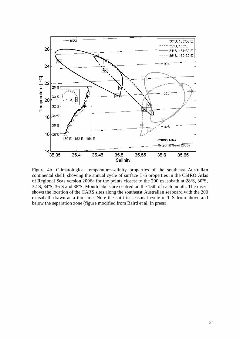
Figure 4b. Climatological temperature-salinity properties of the southeast Australian
continental shelf, showing the annual cycle of surface T-S properties in the CSIRO Atlas
of Regional Seas version 2006a for the points closest to the 200 m isobath at 28ºS, 30ºS,
32ºS, 34ºS, 36ºS and 38ºS. Month labels are centred on the 15th of each month. The insert
shows the location of the CARS sites along the southeast Australian seaboard with the 200
m isobath drawn as a thin line. Note the shift in seasonal cycle in T-S from above and
below the separation zone (figure modified from Baird et al. in press).

22
Figure 4c. The nitrate climatology for the region, for <200 m from the surface, derived
from CARS (Suthers et al. submitted to DSR-II). Scale bar in μM.

23
2c) Research Questions to be addressed by NSW-IMOS:
The key research aims pertinent to NSW-IMOS are:
1) To contribute to national observations of decadal changes and climate variability of the
EAC, Leeuwin, and Flinders Currents using common platforms and metrics.
i) To determine the variability in EAC strength from its source in the Coral Sea, the
seasonal and spatial variability in the separation of the EAC from central NSW, and the
EAC‟s southward extension;
ii) Contribute to monitoring the Bass Strait outflow and the northward coastally trapped
wave propagation;
iii) Contribute to the national backbone through the National Reference Station network and
the supplementation of Satellite Remote Sensing products with local data.
2) To investigate the EAC, its separation from the coast, and the resultant eddy field
along the coast of SE Australia.
i) To determine the frequency, form and function (horizontal and vertical) of EAC
eddies;
ii) To understand air sea interactions, particularly to determine the development of East
Coast Lows and severe winter storms in relation to warm core eddies;
iii) Quantify the impact of key physical processes such as onshore encroachment of the
EAC, slope water intrusions, upwelling, downwelling and internal waves.
3) To quantify oceanographic processes on the continental shelf and slope of SE
Australia: i) Examine the coastal wind and wave climate in driving nearshore currents and the
northward sediment transport;
ii) Quantify the biogeochemical cycling of carbon (nutrients and phytoplankton
composition);
iii) Determine the transport and dispersal of passive particles (e.g. larvae, eggs, spores)
and the degree of along coast connectivity and trophic linkages.
4) Integrate the ecosystem response with oceanographic processes:
i) Quantify the daily to decadal variation of planktonic communities in relation to
oceanographic and climate-driven changes in physical and chemical ocean
properties;
ii) Quantify rocky reef biota variables (kelp distribution and abundance) associated with
climate variability, at with deep reefs along the NSW to Tasmanian coast;
iii) Relationship of the EAC, its eddies and oceanographic conditions on fisheries, and
movements by fish and sharks;
iv) Quantify the seasonal and yearly variation of upper-predator (fish and marine
mammal) communities.

24
2d) How will NSW-IMOS activities fit within a national IMOS, in relation to
the node-specific IMOS strategic priorities 2009-2013?
Ongoing development of a coherent, well-positioned Bluewater and Climate (BWC) Node
BWC provides essential context for our regional observations:
1) The SOOP-XBT line from Brisbane to Noumea provides the annual trends in the EAC
heat flux across the Tasman Front (e.g. Ridgway et al. 2008), while we in turn support
BWC with the resultant EAC-shelf interaction north and south of the separation zone.
2) Opportunistic profiles of temperature and salinity through selected EAC eddies are
provided by the ARGO program, while our gliders can be targeted to sample eddies that
are missed by ARGO floats;
3) NSW-IMOS welcomes sustained data from the SOOP-CPR line from Brisbane-Sydney-
Melbourne-Adelaide, which will provide long term data on the distribution of plankton
along the eastern and south-eastern Australian coast. In turn, our goal is to compare the
CPR and bio-acoustic data for the region with phytoplankton and zooplankton data from
the National Reference Transect off Port Hacking.
4) We need the Blue Water & Climate‟s EAC shelf to abyss mooring line off southern
Queensland as it will identify the full depth EAC transport and variability, which forms
the upstream condition of the EAC inflow along the NSW coast.
Providing a national backbone for observing boundary currents
NSW-IMOS contributes to the national boundary current observations through:
Biogeochemical sampling at the National Reference Station off Sydney, and to provide
validation data for bio-optical sensors and satellite match-up data for Satellite Remote
Sensing;
Continuing the long-term (70 year) biogeochemical sampling along the National
Reference Transect combined with the four oceanographic moorings off Sydney,
providing vertical structure of T, S and velocity. In addition the moorings off Coffs
Harbour, and especially the new mooring pair off southern NSW (Bateman‟s Bay/Eden),
will provide data in Australia‟s most variable region which is the most problematic
region for BLUElink ocean forecasts.
Observing detailed structure of the EAC and eddies (especially vertical structure from
gliders), to complement serendipitous ARGO profiles;
Contributing to the calibration of remotely sensed observations through addition of bio-
optical sensors to the mooring network and appropriate biogeochemical sampling.
Assessing the ecological implications of varying boundary currents by monitoring the
movements of nationally migrating specie (such as white shark); as well as
phytoplankton and zooplankton composition at the National Reference Transect;
Assessment of the distribution and abundance of kelp and other deep reef biota and how
this is changing at numerous locations in Australia.
The NSW-IMOS science plan provides essential “up-stream” observations for the waters
further south (i.e. relevant to Tas-IMOS), and examines the teleconnections of
meteorological and oceanographic forcing.
NSW-IMOS complements the Blue Water & Climate and Q-IMOS deepwater mooring
array at 27ºS (where the EAC is most coherent), with the Coffs Harbour mooring array
and HF radar measurements of surface velocity.

25
Ongoing development of the Regional Nodes?
At the mid-term Review, the progress of NSW-IMOS and SIMS since their independent
beginnings in 2006 was acknowledged, but “further institutional support was required from
within NSW to strengthen the node”. In March 2009 the deputy premier of NSW Carmel Tebutt,
along with the chair of the Ian Potter Foundation, and the chair of SIMS jointly announced the
release of $1.8M to support the development of SIMS in coastal geomorphology/oceanography
and marine biotechnology, and to lease the last remaining building at the Chowder Bay precinct.
In 2010, the NSW state government awarded NSW-IMOS $600,000 to contribute to IMOS
personnel to provide technical support through to mid 2013 to facilitate the deployment,
maintenance and analysis of NSW-IMOS data streams.
In May 2009, SIMS was successful with a $19.5M EIF grant to refurbish buildings, create
laboratories, improve seawater supplies and purchase vehicles and boats. In July 2009 Professor
Peter Steinberg took up position as Director of SIMS. Since the mid-term review in 2009 there
have been several marine academic appointments (tenured) in NSW with significant interests in
IMOS including: Dr Martina Doblin (UTS), Dr Leanne Armand (Macquarie U.), Dr Matthew
Taylor (UNSW), Dr Adriana Verges (UNSW), Dr Will Figueria (U.Syd), Professor William
Gladstone (UTS), Dr Peter Biro (Future Fellow, UNSW).

26
3. Pre-existing observations
3-1) What sustained pre-IMOS observations already exist in the region?
Prior to IMOS the main broadscale data supporting the EAC descriptions and models came
from: remote sensing (sea level elevation and sea surface temperature), two high density repeat
XBT sections from Brisbane (27◦S) to Fiji, and Sydney (34
◦S) to Wellington, NZ (Ridgway et
al., 2008) and from 2 years of moorings and hydrography off 30◦S (Mata et al., 2000). Extensive
regional data is also available from the RV Franklin surveys and short mooring deployments
conducted by CSIRO (e.g. Hamon, 1965, 1968; Cresswell, 1974, 1976; Cresswell et al., 1983;
Cresswell, 1994; Godfrey et al., 1980a,b, inter alia) and the UNSW Coastal and Regional
Oceanography Laboratory over the past 40 years (e.g. Griffin and Middleton, 1992; Gibbs et al.,
1998; Oke and Middleton, 2000; Roughan and Middleton, 2002, 2004; Baird et al., 2008, inter
alia).
Off Port Hacking, Sydney (34.05◦S) is one of Australia‟s longest running hydrographic
monitoring stations (since 1942), at the 50 m and 100 m isobaths (PH050, PH100). Instigated
initially by CSIRO Marine Research (now CMAR), in recent decades the monthly monitoring
has been run for CMAR by NSW Department of Environment, Climate Change and Water
(DECCW).
Initially temperature was monitored (using reversing thermometers) at nominally monthly
intervals at the CSIRO long term monitoring stations: PH050 (d=0,10,20,30,40,50 m) and
PH100 (d=0,10,25,50,75,100 m). Monthly CTD profiles have been sampled by DECCW at
PH025, PH050, PH100 and PH125 since 1997 (Table 1; Fig. 5). Zooplankton samples have also
been collected at the two stations since 1997. In addition to the monthly sampling an intensive
period of weekly sampling was undertaken in 1997 (Ajani et al., 2001) to replicate studies
undertaken 20 years earlier (Hallegraeff and Jeffrey, 1993). Monthly plankton net samples from
PH050 and PH100 have been collected and preserved for the period April 1997 - March 1998
and then November 1998 to the present. Some of the data from this long term sampling are
presented in (Thompson et al., 2009). This valuable time-series assessment of the
phytoplankton composition is now being continued through PhD research at Macquarie
University and is supported by a Government APA, ABRS and NSW Safe Foods funding
(Ajani, 2010-2012).
Table 1. National Reference Transect: Port Hacking (Sydney)
Station (water depth) Latitude Longitude
PH025 (25m) S 34o 04.94‟ E 151
o 10.79‟
PH050* (55m) S 34o 05.35‟ E 151
o 11.35‟
PH100* (105m) S 34o 06.98‟ E 151
o 13.14‟
PH125 (125m) S 34o 08.88‟ E 151
o 15.37‟
* CSIRO collected or funded sampling for temperature and nutrients, since 1942.
Lobster puerulus have been collected monthly from collectors deployed during the spring-
autumn period off Coffs Harbour, Tuncurry, Sydney and Ulladulla since 1995. Associated
invertebrates were not retained except for 2006-2007 and 2008-09.
There is only one site of sustained moored observations of the ocean along the coast of NSW,
the Ocean Reference Station (ORS), which has been in operation off Sydney since November
1989. The ORS provides Sydney Water Corporation with oceanographic data, required as part
of their operating licence for the discharge of sewage. This mooring is currently operated by
Oceanographic Field Services (OFS). The ORS is located 3 km off Bondi Beach, in 65 m of
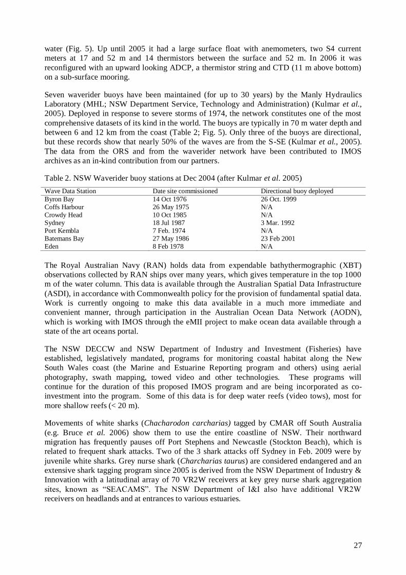
27
water (Fig. 5). Up until 2005 it had a large surface float with anemometers, two S4 current
meters at 17 and 52 m and 14 thermistors between the surface and 52 m. In 2006 it was
reconfigured with an upward looking ADCP, a thermistor string and CTD (11 m above bottom)
on a sub-surface mooring.
Seven waverider buoys have been maintained (for up to 30 years) by the Manly Hydraulics
Laboratory (MHL; NSW Department Service, Technology and Administration) (Kulmar et al.,
2005). Deployed in response to severe storms of 1974, the network constitutes one of the most
comprehensive datasets of its kind in the world. The buoys are typically in 70 m water depth and
between 6 and 12 km from the coast (Table 2; Fig. 5). Only three of the buoys are directional,
but these records show that nearly 50% of the waves are from the S-SE (Kulmar et al., 2005).
The data from the ORS and from the waverider network have been contributed to IMOS
archives as an in-kind contribution from our partners.
Table 2. NSW Waverider buoy stations at Dec 2004 (after Kulmar et al. 2005)
Wave Data Station Date site commissioned Directional buoy deployed
Byron Bay 14 Oct 1976 26 Oct. 1999
Coffs Harbour 26 May 1975 N/A
Crowdy Head 10 Oct 1985 N/A
Sydney 18 Jul 1987 3 Mar. 1992
Port Kembla 7 Feb. 1974 N/A
Batemans Bay 27 May 1986 23 Feb 2001
Eden 8 Feb 1978 N/A
The Royal Australian Navy (RAN) holds data from expendable bathythermographic (XBT)
observations collected by RAN ships over many years, which gives temperature in the top 1000
m of the water column. This data is available through the Australian Spatial Data Infrastructure
(ASDI), in accordance with Commonwealth policy for the provision of fundamental spatial data.
Work is currently ongoing to make this data available in a much more immediate and
convenient manner, through participation in the Australian Ocean Data Network (AODN),
which is working with IMOS through the eMII project to make ocean data available through a
state of the art oceans portal.
The NSW DECCW and NSW Department of Industry and Investment (Fisheries) have
established, legislatively mandated, programs for monitoring coastal habitat along the New
South Wales coast (the Marine and Estuarine Reporting program and others) using aerial
photography, swath mapping, towed video and other technologies. These programs will
continue for the duration of this proposed IMOS program and are being incorporated as co-
investment into the program. Some of this data is for deep water reefs (video tows), most for
more shallow reefs (< 20 m).
Movements of white sharks (Chacharodon carcharias) tagged by CMAR off South Australia
(e.g. Bruce et al. 2006) show them to use the entire coastline of NSW. Their northward
migration has frequently pauses off Port Stephens and Newcastle (Stockton Beach), which is
related to frequent shark attacks. Two of the 3 shark attacks off Sydney in Feb. 2009 were by
juvenile white sharks. Grey nurse shark (Charcharias taurus) are considered endangered and an
extensive shark tagging program since 2005 is derived from the NSW Department of Industry &
Innovation with a latitudinal array of 70 VR2W receivers at key grey nurse shark aggregation
sites, known as “SEACAMS”. The NSW Department of I&I also have additional VR2W
receivers on headlands and at entrances to various estuaries.

28
3-2) Existing IMOS observations for NSW-IMOS already online and
justification of on-going need
3-2.1 Ocean Moorings (ANMN) – NSW sub-facility
Moninya Roughan, Brad Morris, Tim Pritchard, Hua Wang, Martina Doblin, Leanne
Armand, Iain Suthers, et al.
The NSW-IMOS ANMN sub-facility has been collecting temperature and velocity time series
data from the two Sydney moorings SYD100 and SYD140 (Fig. 5) since June 2008. Recently,
Water Quality Monitor data has been delivered from 28 m depth at SYD100 (since October
2009) and from the PH100 mooring (since May 2010). In addition, time series of temperature,
salinity and velocity from ORS065 (Ocean Reference Station) off Bondi (Fig. 5) have been
obtained as an in-kind contribution from Sydney Water Corporation (1989 to present). Details of
the NSW-IMOS moorings are shown in Table 3 and the data coverage to date for these data
streams is shown in Fig. 6. These data are now being delivered to eMII.
Figure 5. Map showing locations of NSW-IMOS moorings, including moorings already
deployed and the Eden mooring to be deployed. Also shown are the locations of the
current hydrographic sampling sites, the waverider buoy network, the ocean reference station, the HR radar coverage and the current AATAMS lines. (Roughan et al. 2010a)
Two moorings off Coffs Harbour, CH070 and CH100, locations shown in Fig. 5, were deployed
in August 2009. The data coverage for these data streams is shown in Fig. 6, and these data are
now being delivered to eMII. The temperature and velocity data sets from the mooring off Jervis
Bay, JB070 (Fig. 5), are currently being made available via eMII.

29
Figure 6 Data coverage to date for NSW-IMOS moorings; CH070, CH100, ORS065,
SYD100, SYD140, PH100 and JB070 from initial deployment (late June 2008- present).
These data are now flowing to the eMII Ocean Data Portal. T = temperature; V = velocity, BGC= Fluorescence, salinity and turbidity sensors.
Data from the seven waverider buoys deployed off the NSW coast (for locations see Fig. 5) are
supplied as an in-kind contribution by MHL to IMOS.
Monthly hydrographic sampling has been undertaken along the NSW-IMOS National Reference
Transect at 4 sites off Port Hacking (Fig. 5). Conductivity, Temperature & Depth (CTD) profiles
are taken at each site along with water quality, phytoplankton pigment sampling at PH50 and
PH100 plus a plankton net sample and a water sample for genetic analysis at PH100. These
biogeochemical data are being made available via eMII. There is considerable trawling around
PH50 and PH100 and this region is regarded as an unsafe location for a long-term mooring.
Nevertheless, because of the historical significance of the region, the PH100 mooring is being
trialled and has so far survived.
Table 3. Details of NSW-IMOS mooring sites.
Mooring Latitude Longitude Depth (m) Distance offshore (km)
CH070 S 30º 16.50‟ E 153º 18.00‟ 70 14.8
CH100 S 30º 16.08‟ E 153º 23.82‟ 100 24.2
ORS065# S 33º 53.85‟ E 151º 18.92‟ 65 2.1
SYD100 S 33º 56.57‟ E 151º 22.92‟ 100 9.9
SYD140 S 34º 59.66‟ E 151º 27.52‟ 140 19.0
PH100* S 34º 06.98‟ E 151º 13.14‟ 100 6.1
JB070 ̂ S 35º 04.98‟ E 150º 51.00‟ 78 1.5
ED100* S 37º 18.96‟ E 150º 19.50‟ 100 18.5
#Mooring maintained and operated by Sydney Water Corporation since Nov. 198.9
^Mooring deployed by UNSW ADFA.
*The actual location of this mooring is still to be finalised.
There is an ongoing need to continue collection of the data streams from all of the existing
mooring locations in order to obtain sustained observations of the EAC, its interaction with the
continental shelf along with the key continental shelf processes of SE Australia. Likewise data
collected at the National Reference Transect provides sustained observations of the
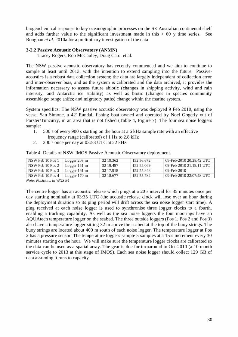
30
biogeochemical response to key oceanographic processes on the SE Australian continental shelf
and adds further value to the significant investment made in this > 60 y time series. See
Roughan et al. 2010a for a preliminary investigation of the data.
3-2.2 Passive Acoustic Observatory (ANMN)
Tracey Rogers, Rob McCauley, Doug Cato, et al.
The NSW passive acoustic observatory has recently commenced and we aim to continue to
sample at least until 2013, with the intention to extend sampling into the future. Passive-
acoustics is a robust data collection system; the data are largely independent of collection error
and inter-observer bias, and as the system is calibrated and the data archived, it provides the
information necessary to assess future abiotic (changes in shipping activity, wind and rain
intensity, and Antarctic ice stability) as well as biotic (changes in species community
assemblage; range shifts; and migratory paths) change within the marine system.
System specifics: The NSW passive acoustic observatory was deployed 9 Feb 2010, using the
vessel San Simone, a 42' Randall fishing boat owned and operated by Noel Gogerly out of
Forster/Tuncurry, in an area that is not fished (Table 4, Figure 7). The four sea noise loggers
sample:
1. 500 s of every 900 s starting on the hour at a 6 kHz sample rate with an effective
frequency range (calibrated) of 1 Hz to 2.8 kHz
2. 200 s once per day at 03:53 UTC at 22 kHz.
Table 4. Details of NSW-IMOS Passive Acoustic Observatory deployment.
NSW Feb 10 Pos 1 Logger 208 m 32 19.362 152 56.672 09-Feb-2010 20:28:42 UTC
NSW Feb 10 Pos 2 Logger 151 m 32 19.497 152 55.069 09-Feb-2010 21:19:11 UTC
NSW Feb 10 Pos 3 Logger 161 m 32 17.918 152 55.848 09-Feb-2010
NSW Feb 10 Pos 4 Logger 170 m 32 18.677 152 55.784 09-Feb-2010 22:07:48 UTC
Note: Positions in WGS 84
The centre logger has an acoustic release which pings at a 20 s interval for 35 minutes once per
day starting nominally at 03:35 UTC (the acoustic release clock will lose over an hour during
the deployment duration so its ping period will drift across the sea noise logger start time). A
ping received at each noise logger is used to synchronise three logger clocks to a fourth,
enabling a tracking capability. As well as the sea noise loggers the four moorings have an
AQUAtech temperature logger on the seabed. The three outside loggers (Pos 1, Pos 2 and Pos 3)
also have a temperature logger sitting 32 m above the seabed at the top of the buoy strings. The
buoy strings are located about 400 m south of each noise logger. The temperature logger at Pos
2 has a pressure sensor. The temperature loggers sample 5 samples at a 15 s increment every 30
minutes starting on the hour. We will make sure the temperature logger clocks are calibrated so
the data can be used as a spatial array. The gear is due for turnaround in Oct-2010 (a 10 month
service cycle to 2013 at this stage of IMOS). Each sea noise logger should collect 129 GB of
data assuming it runs to capacity.
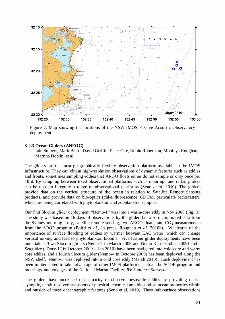
31
Figure 7. Map showing the locations of the NSW-IMOS Passive Acoustic Observatory
deployment.
3-2.3 Ocean Gliders (ANFOG)
Iain Suthers, Mark Baird, David Griffin, Peter Oke, Robin Robertson, Moninya Roughan,
Martina Doblin, et al.
The gliders are the most geographically flexible observation platform available in the IMOS
infrastructure. They can obtain high-resolution observations of dynamic features such as eddies
and fronts, sometimes sampling eddies that ARGO floats either do not sample or only once per
10 d. By sampling between fixed observational platforms such as moorings and radar, gliders
can be used to integrate a range of observational platforms (Send et al. 2010). The gliders
provide data on the vertical structure of the ocean in relation to Satellite Remote Sensing
products, and provide data on bio-optics (chl-a fluorescence, CDOM, particulate backscatter),
which are being correlated with phytoplankton and zooplankton samples.
Our first Slocum glider deployment “Nemo-1” was into a warm-core eddy in Nov 2008 (Fig. 8).
The study was based on 16 days of observations by the glider, but also incorporated data from
the Sydney mooring array, satellite remote sensing, two ARGO floats, and CO2 measurements
from the SOOP program (Baird et al., in press, Roughan et al. 2010b). We learnt of the
importance of surface flooding of eddies by warmer buoyant EAC water, which can change
vertical mixing and lead to phytoplankton blooms. Five further glider deployments have been
undertaken. Two Slocum gliders (Nemo-2 in March 2009 and Nemo-3 in October 2009) and a
Seaglider (“Dory-1” in October 2009 – Jan 2010) have been navigated into cold-core and warm
core eddies, and a fourth Slocum glider (Nemo-4 in October 2009) has been deployed along the
NSW shelf. Nemo-5 was deployed into a cold core eddy (March 2010). Each deployment has
been implemented to take advantage of other IMOS platforms such as the SOOP program and
moorings, and voyages of the National Marine Facility, RV Southern Surveyor.
The gliders have increased our capacity to observe mesoscale eddies by providing quasi-
synoptic, depth-resolved snapshots of physical, chemical and bio-optical ocean properties within
and outside of these oceanographic features (Send et al. 2010). These sub-surface observations
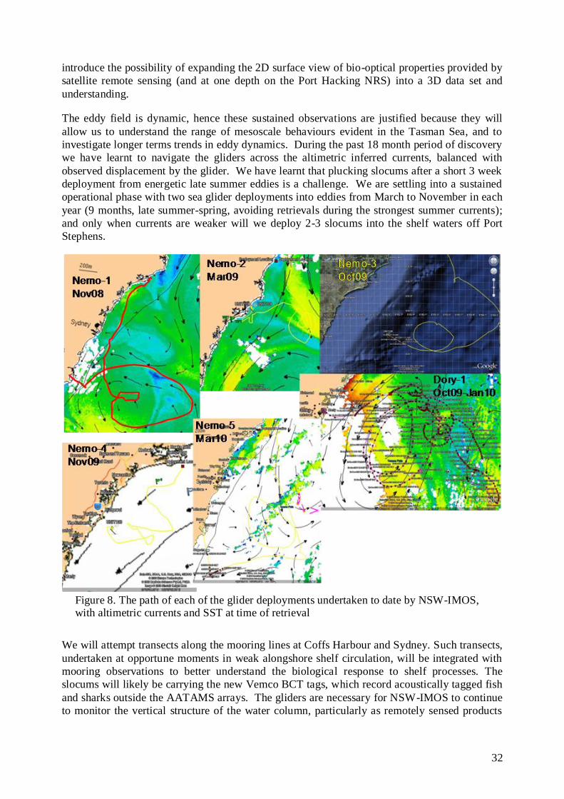
32
introduce the possibility of expanding the 2D surface view of bio-optical properties provided by
satellite remote sensing (and at one depth on the Port Hacking NRS) into a 3D data set and
understanding.
The eddy field is dynamic, hence these sustained observations are justified because they will
allow us to understand the range of mesoscale behaviours evident in the Tasman Sea, and to
investigate longer terms trends in eddy dynamics. During the past 18 month period of discovery
we have learnt to navigate the gliders across the altimetric inferred currents, balanced with
observed displacement by the glider. We have learnt that plucking slocums after a short 3 week
deployment from energetic late summer eddies is a challenge. We are settling into a sustained
operational phase with two sea glider deployments into eddies from March to November in each
year (9 months, late summer-spring, avoiding retrievals during the strongest summer currents);
and only when currents are weaker will we deploy 2-3 slocums into the shelf waters off Port
Stephens.
Figure 8. The path of each of the glider deployments undertaken to date by NSW-IMOS, with altimetric currents and SST at time of retrieval
We will attempt transects along the mooring lines at Coffs Harbour and Sydney. Such transects,
undertaken at opportune moments in weak alongshore shelf circulation, will be integrated with
mooring observations to better understand the biological response to shelf processes. The
slocums will likely be carrying the new Vemco BCT tags, which record acoustically tagged fish
and sharks outside the AATAMS arrays. The gliders are necessary for NSW-IMOS to continue
to monitor the vertical structure of the water column, particularly as remotely sensed products
33
have limited vertical resolution and surface flooding of cold core eddies by the warm, buoyant
water of the EAC limits our observations of cyclonic (clockwise rotating) eddies.
3-2.4 Autonomous Underwater Vehicle (AUV – the “Sirius”)
Peter Steinberg, Stefan Williams, David Booth, Tim Pritchard, Maria Byrne, Will
Figueira, Brendan Kelaher, Alan Jordan, et al.
The focus of the IMOS AUV Facility deployments has predominantly centred on activities in
other regions of the country. These activities were supported as a result of a call for proposals
for deployment of the vehicle. However the data sets that have been collected have created
demand for the AUV within NSW. A number of deployments were undertaken in NSW in and
around Jervis Bay as there was interest in this region from DECCW. A number of data sets from
inside the bay itself are available. Sustained observations of deepwater habitats are needed to
assess the effects of - and ecological adaptations to - a warming coastal ocean, and the efficacy
of marine park planning.
Additional support for this facility has been demonstrated with a Super Science Fellowship
being awarded (2010) to U.Syd and U.Tas (Stefan Williams, Maria Byrne, Neville Barrett and
Will Figueira) for a project on “Machine assisted- Multi-scale Spatial and Temporal
Observation and Modeling of Marine Benthic Habitats”. Another was awarded to UTas and
UNSW to examine “Effects of climate change on temperate benthic assemblages on the
continental shelf in eastern Australia”.
3-2.5 Animal Tracking (AATAMS) Matthew Taylor, Rob Harcourt, Charles Gray, David Booth, Tim Pritchard, Iain Suthers,
et al.
The NSW-AATAMS facility aims to determine fine- and broad-scale movements of iconic fish
and sharks in relation to their hydrographic, bathymetric and oceanographic habitats, as well as
the dynamic biotic properties (e.g. zooplankton and phytoplankton dynamics) of the coastal
zone. The Sydney transect has only been deployed since mid 2008 (Fig. 5) and with downloads
every 6 months (managed by NSW-AATAMS) the data is now coming to hand. The
continuation of NSW-AATAMS is justified to capitalize on the 3 y life of some tags and to
document the effects of EAC activity and rainfall on animal movements. This work will focus
on the influence of prevailing boundary currents (EAC) on migration across latitudinal
gradients; the influence of drought, rainfall and coastal oceanography on connectivity between
estuaries and coastal waters, and the relationship between estuarine hydrography, coastal
oceanography, trophic interactions and habitat use. The influence of rainfall on coastal
movements is a key question for NSW in the behaviour of sharks and to scientifically base
environmental flow regulations (Taylor et al., ARC-Linkage project 2010-2012).
Observations will be made of key species, including apex predators, substantial fisheries targets,
and endangered and threatened species, which demonstrate varying degrees of coastal migration.
Specifically, these species include mulloway, dusky flathead, yellowfin bream, Australian
salmon, mullet, blue grouper, and wobbegong, grey nurse shark, great white, bull and dusky
sharks. AATAMS is needed off NSW to support evidence-based planning and zoning of NSW
marine parks, by examining the nature of connectivity amongst coastal marine parks for adult
fish populations; and residence time, use of sanctuary zones, and connectivity between zones of
differing protection within marine parks.

34
3-2.6 High Frequency Coastal Radar.
Moninya Roughan, Tim Pritchard, Mal Heron, Brad Morris, et al.
We plan to deploy a high frequency coastal radar (WERA) off Coffs Harbour (30ºS) which will
provide surface current velocities, and when combined with the data from the waverider buoy
network will provide important information regarding the wave climate along the coast of NSW.
This radar was to have been deployed in 2009 as part of the original NCRIS funded IMOS
(2006-2011) but has experienced delays and has been postponed by the ACORN facility. This
equipment is an integral component of our observing system. As the shelf is narrow the
coverage of the high frequency radar will typically reach to the core of the EAC providing vital
information on the variability of the current as well as the encroachment of the EAC onto the
continental shelf.

35
4-1) What observations does NSW-IMOS require?
The following strategy uses the national backbone to address our 4 key research questions
(Section 2c), concerning the East Australian Current and the separation zone. We build on the
interdisciplinary data collected along the coast of NSW to date, in a national context with other
boundary current systems from the western Pacific and from the Great Australian Bight (GAB).
In the following we list the observations required by facility and in section 4.2 we restate these
research questions and the observational strategy needed to answer them. Research Question 1
provides the national agenda, with oceanographic signals from the south Coral Sea and the GAB
being manifest in waters off NSW, Tasmania, and Western Australia.
4-1.1 Ocean Moorings (ANMN)
Moninya Roughan, Brad Morris, Tim Pritchard, Hua Wang, Martina Doblin, Leanne
Armand, Iain Suthers, et al.
With full depth monitoring of the EAC at 28ºS off Stradbroke Island (Q-IMOS), our mooring
program needs cross-shelf (at least paired) moorings in 4 key regions; Coffs Harbour (30ºS),
Stockton Bight-Separation zone (32ºS), Sydney/Port Hacking (34ºS), and southern NSW
(Batemans Bay or Eden, 37ºS, Fig. 5). This is the backbone of the NSW-IMOS observing
system and the data will contribute to each of the 4 research questions. We will continue the
sampling that we have implemented in the first phase of IMOS. This includes the maintenance
and delivery of data from 8 oceanographic moorings along the coast of NSW, at Coffs Harbour
(2 moorings across the shelf), Sydney-Port Hacking, (4 moorings across the shelf), Southern
NSW (Bateman‟s/Eden) (2 moorings), and we will maintain, with NSW-DECCW, the monthly
biogeochemical sampling at 4 stations along the Port Hacking transect (Fig. 5).
Some enhancements that should be implemented in the future include:
a) Real time telemetry off Sydney is needed to improve model output by its inclusion in
ocean forecasts and re-analysis products, as well as making the data immediately
available to the science community and the general public. It will also allow rapid
response to events and when instruments fail, thus avoiding large data gaps.
b) A mooring pair in the Stockton Bight region – separation zone, under the HF Radar
footprint (see below).
c) Installation of bio-optical sensors on the Port Hacking national reference station. The
proposed PAR, Ecotriplet (chl-a fluorescence, CDOM fluorescence and backscatter)
and excitation-emission fluorometer sensors will provide data describing in situ light
fields, the type and quantity of dissolved and particulate constituents of water (that
absorb and scatter light), as well as the photosynthetic rates of primary producers,
allowing a mechanistic understanding of lower trophic level responses to physical
forcing.
d) We require the addition of high resolution pressure sensors at the base of each of our
moorings to provide a long term time series of sea level elevation and allow for the
resolution of coastally trapped waves from Bass Strait.
e) Consolidation of the south coast (Eden) moorings may be considered when the Tas-
IMOS moorings are deployed. Similarly, the Coffs mooring data will be compared
to the Stradbroke Island array when shelf data becomes available, but the Coffs-
Sydney moorings provide us with crucial information on the separation dynamics.

36
4-1.2 Ocean Gliders (ANFOG)
Iain Suthers, Mark Baird, David Griffin, Peter Oke, Martina Doblin, Moninya Roughan,
Robin Robertson, Andrew Kiss, et al.
Glider deployments provide the most spatially flexible observational platform to target warm
and cold core eddies off NSW, especially in the absence of ARGO profiles. Through high-
resolution vertical physical and bio-optical profiles, they also provide a link between remote
sensing (spatially-broad) and mooring (temporally-resolved) observations. We require 2-3
Slocum Gliders per year for sustained cross-shelf profiles; and 2 SeaGlider deployments per
year for observing eddy structure and function during late winter-midsummer. Glider retrievals
are more difficult in late summer and will be avoided. The ocean gliders will answer Research
Question 2, and contribute to answering 4, particularly with regard to the surface flooding of
eddies by less dense EAC water.
4-1.3 Animal Tracking AATAMS
Matt Taylor, Iain Suthers, Charles Gray, Nick Otway, Amy Smoothie, Vic Peddermors,
David Booth, Rob Harcourt, Barry Bruce, et al.
The movements of fish, sharks and other vertebrates, when coupled with our ocean observations
will contribute to the goal of integrated, ecosystem studies. We have only limited knowledge of
the north-south movements of fish, sharks and whales, but remarkably we have no knowledge of
the oceanographic or estuarine influences on these movements. The continued operation of the
AATAMS transects at our focal regions off Coffs Harbour and Sydney is essential to match the
location of the moorings and HF radar and the movements through the separation zone. It is
also essential to complement the existing VR2 networks in NSW with a robust and accountable
portal through eMII to upload VRL files for the national community and their animal tracking
programs, both large and small.
In addition we need additional transects through Bateman‟s Bay (or Jervis Bay) marine park to
complement the new south coast mooring (36 or 37ºS). Some enhancements that should be
implemented in the future are “seals as samplers” program. It is possible to monitor the ocean
using marine mammals to provide a remarkable range of information on oceanographic
properties, directly related to the foraging habits of large marine mammals. It is highly
desirable to implement such a program in southern NSW at the seal colonies of Montague Island
(36º15‟S).
4-1.4 Autonomous Underwater Vehicle Facility (AUV, the “Sirius”)
Peter Steinberg, Stefan Williams, David Booth, Tim Pritchard, Maria Byrne, Will
Figueira, Alan Jordan, et al.
SIRIUS: To assess changes in depth of kelp distribution along the NSW coast, cross-shelf
transects will be conducted at 2 sites within 3 locations in NSW (Cape Byron Marine Park
(28.5ºS), Port Stephens Great Lakes Marine Park (32.5ºS) and Batemans Marine Park (35-36ºS).
These cross-shelf benthic transects will examine the longer-term effects of benthic pelagic
coupling and the impact of the EAC warming. Wherever possible, sites are located within
protected sanctuary zones of marine parks where all forms of commercial and recreational
fishing and harvesting (which could confound climate-related impacts on kelp) are prohibited.
To assess latitudinal changes in Ecklonia distribution, sampling will be conducted at four main
sampling locations that overlap with the sites above. These locations are chosen to span areas
close to the northernmost limit of Ecklonia kelp forest on the east coast (e.g. Byron Bay) to well
within its southern distribution in NSW (Batemans Marine Park). The northernmost location is

37
perhaps most important as it is where we expect to see early/existing changes in kelp
distributions. These long term AUV transects will answer Research Question 4ii, and will likely
contribute to 4iv.
REMUS: When future funding becomes available we propose a series of repeat AUV REMUS
lines co-incident with the Coffs Harbour and Sydney mooring arrays to provide the spatial
context for the point wise measurements of velocity, temperature and salinity obtained at the
mooring arrays. The proposed sites coincide with existing IMOS infrastructure associated with
other facilities and the observations that we will obtain complement the extant data sets (e.g
ANMN transects). These sites will also feature observations provided by coastal radar and,
where possible, glider deployments. See Appendix 3.
4-1.5 Australian Coastal Ocean Radar Network (ACORN)
Moninya Roughan, Mal Heron, Tim Pritchard, Iain Suthers, Brad Morris, et al.
HF Radar provides unprecedented time resolved surface maps (to 1m depth) of ocean currents in
near real time in support of innumerable applications in physical and biological ocean research
as well as operational aspects of invaluable benefit to the coastal community. There is also the
potential to obtain wave information and wind direction from the phased array (WERA).
We require a short range HF Radar (WERA) system for the Coffs Harbour region (this was
approved in 2008, however it has not yet been installed). In addition to this we require a long
range HF Radar system that will cover the EAC separation/eddy generation region from 30-
350S, requiring up to 5 stations (See Appendix 3 and Fig. 9).
NSW HF radar deployments will also be used to investigate dynamic processes and flow
patterns including: Interaction of EAC with shelf morphology and coastal boundary layer
effects; Flow patterns in relation to fixed IMOS moorings thus enabling better
interpretation/extrapolation of mooring observations; Physical connectivity pathways in relation
to critical habitats (and marine park zoning in the Solitary Islands Marine Park - SIMP);
Interaction of outflow from coastal catchments and regional currents (EAC); Surface dynamics
of eddies formation and eddy interactions with shelf morphology; Large scale wake effects;
Calibration with wave rider mooring and possibly near-field wave climate with a WaMOS
system; Calibration, verification and assimilation into hydrodynamic models. The NSW-IMOS
radar program has been designed to maximise the number of questions that can be answered
with the infrastructure.
This HF radar deployment which will map the East Australian Current through the region where
separation from the coast usually commences, and which will map the eddies and meanders of
the EAC. The priority is to get continuous spatial coverage over a long coastline and out to sea.
Wave data are also desirable, in regions that overlap with other calibrating infrastructure such as
waverider buoys and moorings.
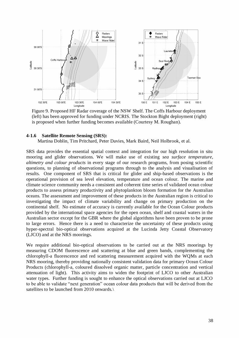
38
Figure 9. Proposed HF Radar coverage of the NSW Shelf. The Coffs Harbour deployment
(left) has been approved for funding under NCRIS. The Stockton Bight deployment (right)
is proposed when further funding becomes available (Courtesy M. Roughan).
4-1.6 Satellite Remote Sensing (SRS):
Martina Doblin, Tim Pritchard, Peter Davies, Mark Baird, Neil Holbrook, et al.
SRS data provides the essential spatial context and integration for our high resolution in situ
mooring and glider observations. We will make use of existing sea surface temperature,
altimetry and colour products in every stage of our research programs, from posing scientific
questions, to planning of observational programs through to the analysis and visualisation of
results. One component of SRS that is critical for glider and ship-based observations is the
operational provision of sea level elevation, temperature and ocean colour. The marine and
climate science community needs a consistent and coherent time series of validated ocean colour
products to assess primary productivity and phytoplankton bloom formation for the Australian
oceans. The assessment and improvement of these products in the Australian region is critical to
investigating the impact of climate variability and change on primary production on the
continental shelf. No estimate of accuracy is currently available for the Ocean Colour products
provided by the international space agencies for the open ocean, shelf and coastal waters in the
Australian sector except for the GBR where the global algorithms have been proven to be prone
to large errors. Hence there is a need to characterize the uncertainty of these products using
hyper-spectral bio-optical observations acquired at the Lucinda Jetty Coastal Observatory
(LJCO) and at the NRS moorings.
We require additional bio-optical observations to be carried out at the NRS moorings by
measuring CDOM fluorescence and scattering at blue and green bands, complementing the
chlorophyll-a fluorescence and red scattering measurement acquired with the WQMs at each
NRS mooring, thereby providing nationally consistent validation data for primary Ocean Colour
Products (chlorophyll-a, coloured dissolved organic matter, particle concentration and vertical
attenuation of light). This activity aims to widen the footprint of LJCO to other Australian
water types. Further funding is sought to enhance the optical observations carried out at LJCO
to be able to validate “next generation” ocean colour data products that will be derived from the
satellites to be launched from 2010 onwards.\
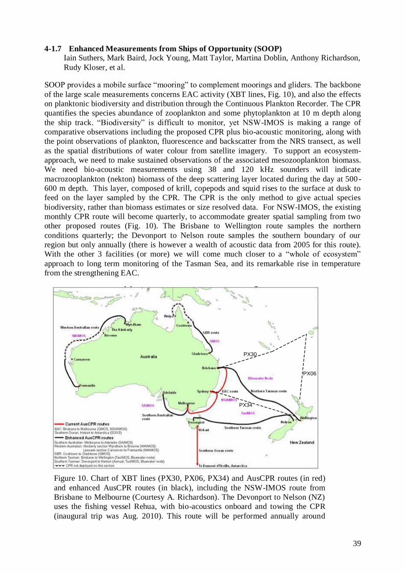
39
4-1.7 Enhanced Measurements from Ships of Opportunity (SOOP)
Iain Suthers, Mark Baird, Jock Young, Matt Taylor, Martina Doblin, Anthony Richardson,
Rudy Kloser, et al.
SOOP provides a mobile surface “mooring” to complement moorings and gliders. The backbone
of the large scale measurements concerns EAC activity (XBT lines, Fig. 10), and also the effects
on planktonic biodiversity and distribution through the Continuous Plankton Recorder. The CPR
quantifies the species abundance of zooplankton and some phytoplankton at 10 m depth along
the ship track. “Biodiversity” is difficult to monitor, yet NSW-IMOS is making a range of
comparative observations including the proposed CPR plus bio-acoustic monitoring, along with
the point observations of plankton, fluorescence and backscatter from the NRS transect, as well
as the spatial distributions of water colour from satellite imagery. To support an ecosystem-
approach, we need to make sustained observations of the associated mesozooplankton biomass.
We need bio-acoustic measurements using 38 and 120 kHz sounders will indicate
macrozooplankton (nekton) biomass of the deep scattering layer located during the day at 500-
600 m depth. This layer, composed of krill, copepods and squid rises to the surface at dusk to
feed on the layer sampled by the CPR. The CPR is the only method to give actual species
biodiversity, rather than biomass estimates or size resolved data. For NSW-IMOS, the existing
monthly CPR route will become quarterly, to accommodate greater spatial sampling from two
other proposed routes (Fig. 10). The Brisbane to Wellington route samples the northern
conditions quarterly; the Devonport to Nelson route samples the southern boundary of our
region but only annually (there is however a wealth of acoustic data from 2005 for this route).
With the other 3 facilities (or more) we will come much closer to a “whole of ecosystem”
approach to long term monitoring of the Tasman Sea, and its remarkable rise in temperature
from the strengthening EAC.
Figure 10. Chart of XBT lines (PX30, PX06, PX34) and AusCPR routes (in red)
and enhanced AusCPR routes (in black), including the NSW-IMOS route from
Brisbane to Melbourne (Courtesy A. Richardson). The Devonport to Nelson (NZ)
uses the fishing vessel Rehua, with bio-acoustics onboard and towing the CPR
(inaugural trip was Aug. 2010). This route will be performed annually around
PX30
PX06
PX34
PX30
PX06
PX34

40
August each year. Integrating bioacoustics on the Brisbane to Melbourne route is being investigated
4-1.8 Passive Acoustic Observatories
Tracey Rogers, Rob McCauley, Doug Cato, et al.
Passive Acoustic Observatories provide measurements of ocean noise, which contains
information on a large number of physical and biological sources. While the focus at this time
is on information inherent in monitoring acoustic data from cetaceans, valuable information on
several other noise sources exists and is also captured, such as acoustic data from other species
(other marine mammals and fish), acoustic sound-scapes associated with changes in shipping
activity, wind and rain intensity, and Antarctic ice stability as well as biotic changes such as:
biological species community assemblage; range shifts; and migratory pathway changes.
We require the continued deployment of the passive acoustics array off central NSW. For
continuity and to better understand temporal patterns, the data sets will be extended into 2103.
Passive-acoustics is a robust data collection system as data is largely independent of collection
error and inter-observer bias. As all the data will be archived it provides useful information on
biological community change, multiple species, not just the target species at the time of the
study, which will be useful to monitor long-term changes in community composition.
4-1.9 Surface Drifters
Moninya Roughan, Brad Morris, Mal Heron, Craig Steinberg, et al.
Drifters provide real time measurements of Lagrangian processes, which are essential for
verification of HF Radar. The development of a coastal drifter facility within IMOS is prudent,
given the use of coastal radar in each of the nodes. In the next phase, we require the use of 12-15
coastal surface drifters 2-3 times per year to provide verification for the coastal radar systems in
Coffs Harbour and in the separation region.
The infrastructure needs for NSW-IMOS and their priority are listed in Table 5.

41
Table 5. A summary of the infrastructure needs and priority (see Appendix 4 for description of column headings).
Infrastructure Priority Comments
Scientific
priority
Technical
Maturity
Capability /
Capacity
Overall
Priority
EAC Deep Water
array 28S
Essential Very
Mature
Capacity
limited
Essential In BWC Node Plan
Coffs Harbour Shelf
Mooring Array
Essential Very
Mature
Capacity and
Capability
Essential Operational
Stockton Bight Shelf
Mooring Array
High
Priority
Very
Mature
Capacity and
Capability
Next Stage
Sydney Shelf
Mooring Array with
real time telemetry
Essential Very
Mature
Capacity and
Capability
Essential Operational but not yet
real time
Port Hacking 100
Mooring
Essential Very
Mature
Capacity and
Capability
Essential Operational
Port Hacking BGC
Transect
Essential Very
Mature
Capacity and
Capability
Essential Operational for >70 y
Passive Acoustics High
Priority
Very
Mature
Capacity
limited
High Priority Operational
Bio-optical sensors
(PAR, ex-em
fluorescence)
High
priority
Very
Mature
Capability and
ltd capacity
Next Stage Require bio-fouling
management
Acidification mooring High
priority
Very
Mature
Capability and
ltd capacity
Next Stage
In-situ dissolved
nutrient sensors
High
priority
Mature Capability and
ltd capacity
Next Stage
ARGO float program High
Priority
Very
Mature
Capacity
limited
Essential Operational
Coffs Harbour short
range HF Radar
(WERA)
Essential Mature Capacity
limited
Essential Not yet operational
EAC Separation Long
Range Radar (30-
35S)
High
Priority
Mature Capacity
limited
Next Stage
Gliders: 3 Slocum p.a Essential Very
Mature
Capacity and
Capability
High Priority Operational
Gliders: 2 Seagliders
p.a.
Essential Very
Mature
Capacity and
Capability
Essential Operational
AUV Sirius Essential Very
Mature
Capacity and
Capability
Essential Operational
AUV Remus High
Priority
Mature Capacity and
Capability
Next Stage Operational
Internationally
AATAMS – Coffs
Harbour Array
Essential Very
Mature
Capacity and
Capability
Essential Operational
AATAMS Sydney
Array
Essential Very
Mature
Capacity and
Capability
Essential Operational
AATAMS – Jervis
Bay Array
High
Priority
Very
Mature
Capacity and
Capability
Next Stage
AATAMS –
Batemans Bay Array
High
Priority
Very
Mature
Capacity and
Capability
Next Stage
AATAMS- Marine High Mature Capacity and Next Stage

42
Mammals SE Coast Priority Capability
SRS - Bio-optical
Instrumentation
Essential Mature Capacity and
Capability
Essential Operational but signals
require validation
SRS SST, SSH
Colour products
Essential Mature Capacity and
Capability
Essential Operational -uncertainty
in optically-complex
waters
SOOP CPR Brisbane
–Melbourne
Essential Very
Mature
Capacity and
Capability
Essential Operational
SOOP XBT EAC
Lines
Essential Very
Mature
Capacity and
Capability
Essential Operational
SOOP Bio-acoustic transects
Essential Very Mature
Capacity and Capability
Essential Not yet operational
Surface Drifters High
Priority
Mature Capability
limited
Next Stage
4-2) How do the observations address the key research questions posed by
NSW-IMOS?
Research Aim 1) To contribute to national observations of decadal changes and climate
variability of the EAC, Leeuwin, and Flinders Currents using common platforms and metrics.
i) To determine the variability in EAC strength from its source in the Coral Sea, the seasonal
and spatial variability in the separation of the EAC from central NSW, and the EAC’s
southward extension;
The newly funded (EIF) mooring array off southern Qld when deployed will measure the EAC
where it is most coherent. This array is essential for an understanding of the seasonal and
decadal variability in the EAC. It will also allow for the first time a comprehensive long term
study of the transport of the EAC complementing the array of Mata et al. (2000). NSW-IMOS
fully support this proposal and see it as an integral component of the NSW-IMOS array as it will
provide the upstream data necessary to inform the EAC inflow and processes along the NSW
shelf.
The NSW-IMOS alongshore mooring array is designed such that we will be able to monitor the
temperature gradients in the EAC along the coast of NSW, north (Coffs) and south (Sydney) of
the separation zone. Combined with the proposed mooring arrays of SE Qld (Q-IMOS) and the
BWC end point array we will gain valuable information in seasonal and decadal changes in the
EAC and its extension along the coast of southern NSW. This data set complements the data
being collected at the Maria Island NRS (Tas-IMOS). Together these data will inform the large
scale changes along Australia‟s eastern continental shelf. This data will also be combined with
crucial biological data (such as kelp distribution and abundance, CPR plankton) providing
information on range shifting which is indicative of changes in the flow field.
Future emphasis (post-2013) on instigating quantitative and sustained biological and chemical
time-series data streams from physical properties moorings at Coffs Harbour, Eden and Maria
Island, will necessitate new scientific aims from the 3 eastern state IMOS nodes. These nodes
are keenly interested in the resulting ecosystem shifts with respect to the EAC boundary current
strengthening.
43
ii) Contribute to monitoring the Bass Strait outflow and the northward coastally trapped wave
propagation;
The deployment of a mooring pair in southern NSW will monitor the Bass Strait outflow and the
addition of pressure sensors on each of the mooring pairs will allow for the measurement of
coastally trapped wave propagation northward along the coast of NSW.
iii) Contribute to the national backbone through the National Reference Station network and the
supplementation of Satellite Remote Sensing products with local data.
Three of the NRS incorporate the long-term (~70 y) hydrographic sampling locations on the
continental shelf (Port Hacking, Maria Island, Rottnest Island) and will provide biogeochemical
data on the effect of boundary current changes (e.g. Thompson et al. 2009). An IMOS-appointed
bio-optical working group containing members of NSW-IMOS are using the NRS data in a
national effort to validate bio-optical signals from the moored time-series at each NRS. A
significant satellite match-up dataset will also be collected in NSW coastal waters during
October 2010 that will support an accuracy assessment of existing SRS products.
Research Aim 2) To investigate the EAC, its separation from the coast and the resultant eddy
field along the coast of SE Australia.
The observing system has been designed to make sustained observations in 4 key regions related
to EAC activity: Coffs Harbour, Stockton Bight, Sydney/Port Hacking, and Bateman‟s
Bay/Eden (Fig. 5). The combination of cross-shore and alongshore arrays will enable us to
investigate seasonal and spatial variability in the EAC along the coast of NSW and its separation
from the coast. We use a combination of moorings, biogeochemical sampling, Satellite Remote
Sensing products, and HF Radar for temporal and spatial coverage. The mooring array gives
good temporal resolution throughout the water column, while the HF radar gives good spatial
coverage at the surface.
Moorings and SRS: We propose to continue the moorings that are currently deployed,
equipped with bio-optical sensors. The combination of cross-shore and alongshore arrays will
enable us to investigate seasonal and spatial variability in the EAC along the coast of NSW and
its separation from the coast.
Biogeochemical Sampling and SRS: Sustaining the monthly biogeochemical sampling at Port
Hacking is key to understanding changes in water-masses and the biological response associated
with the separation of the EAC. Implementing the same water sampling at Coffs Harbour will
allow a comparison with waters upstream of the separation. The supplementation of the NRS
with irradiance sensors (measuring Photosynthetically Active Radiation) and excitation-
emission fluorometers (measuring photosynthetic rate) would be a valuable addition to linking
changes in physical properties to the biological response.
HF Radar: Observations are required upstream of the EAC separation (Coffs Harbour) where
the current is fairly uniform and flows adjacent to the continental shelf). This will provide
detailed information on the EAC prior to separation. To quantify the variability of the separation
itself, detailed HF radar coverage is required spanning the separation region of the EAC (refers
to radar coverage that is now in appendix 3,4) to give spatial coverage of the variability.

44
i) To determine the frequency, form and function (horizontal and vertical) of EAC eddies
Iain Suthers, Mark Baird, Peter Oke, David Griffin, Moninya Roughan, Robin Robertson,
Martina Doblin, Brad Morris, et al.
Warm and cold core eddies are strongly influenced by surface flooding, solar radiative capping,
and by the source waters from which they form (e.g. Baird et al. in press). They can also be the
result of coalescence of two or more eddies. The probably of such events depends in part on the
time of the year and location in which the eddies formed. The EAC mesoscale variability is
difficult to model and further observations and analysis is required.
Gliders and ARGO floats: The requested glider deployments will be used to investigate the
form and function of EAC eddies, and to fill-in under sampled areas by ARGO. The
observations by 24 glider deployments over 4 years are required to provide a broad
understanding of EAC over different time and space scales (particularly season).
Moorings: As the EAC eddies impinge upon the continental shelf they overwhelm the shelf
waters (with velocities ranging 0.5m/s northwards to1.5m/s southwards observed associated
with eddies off Sydney). The shore-normal mooring arrays will help to elucidate the nature of
the eddy interaction with the continental shelf, upwelling and cross-shelf intrusions and the
evolution of the biological response through time series measurements of bio-optical properties.
Bio-optical properties in turn, will be validated with direct measurements of phytoplankton
pigments and biomass from the NRS.
Satellite Remote Sensing is essential for model initialisation and assessment and glider
navigation; to put the glider observations into a regional context, and for SST and surface
chlorophyll.
ii) To understand air sea interactions, particularly to determine the evolution of East Coast
Lows and severe winter storms in relation to warm core eddies.
Milton Speer, Lance Leslie, Ian Goodwin, et al.
The development, intensification and weakening of east coast lows (ECLs) are very dependent
on momentum, heat and moisture fluxes at the air-sea interface from the location of the EAC to
the coast (Leslie et al. 1987; McInnes and Hess 1992). Several studies of ECL systems have
emphasized the importance of the SST gradient from the EAC to the coast as a thermodynamic
feature critical in the evolution of coastal low pressure and trough systems (e.g. Holland et al.
1987; Hopkins and Holland 1997; Speer and Leslie 1998; Speer and Leslie 2000). Recently,
interest has focused on the existence of intense warm core/cold core eddies off the NSW coast in
June 2007 and a possible relationship to the development or intensification of a series of five
east coast lows during June 2007.
Currently there are no fixed offshore-based meteorological observations in the vicinity of the
EAC, so any fixed observations of atmospheric pressure, temperature, dewpoint temperature and
wind speed and direction close to the surface between the coast and the EAC would be
immensely useful in specifying the initial state for numerical weather prediction (NWP) models
in addition to providing a means of NWP verification. It is the intention that the NRS mooring
off Port Hacking that will have data telemetered in real time (PH100) and will also have a
surface met package, which will enable the measurement of some of these crucial
meteorological parameters. High frequency based radar observations of meteorological variables
above the ocean surface may prove possible in future from the radars that are also planned to be
installed.

45
A data base of climate impacts on the NSW coast from marine low pressure systems has been
established and based, so far, on Bureau of Meteorology coastal station rainfall (Speer et al.
2009). It is planned to also include coastal impacts of damage from wind and sea state and
swell. A project between the BoM and DECCW will analyse the synoptic conditions leading up
to severe winter storms off NSW.
Moorings: As an enhancement to the existing mooring network it is proposed that one of the
moorings be converted to real time (PH100). This mooring will have a surface float and a
surface meteorological package. The addition of this over water meteorology observing site will
improve our ability to forecast local weather, and will provide data needed for early warning and
rapid response assessment.
HF Radar: It may be possible to measure surface wind direction with large spatial coverage
from the HF radar systems that we intend to deploy. This is an added advantage of the radar
system.
iii) Quantify the impact of key physical processes such as the onshore encroachment of the EAC,
slope water intrusions, upwelling, downwelling and internal waves.
Moninya Roughan, Brad Morris, Jason Middleton, Peter Tate, et al.
The intrusion of eddies onto the continental shelf overwhelms shelf waters and dominates the
flow field. Temperatures and velocities increase significantly when the EAC or its eddies
encroach on the shelf. The interaction of the EAC with the continental shelf drives shelf edge
upwelling and the separation of the current from the coast is also known to cause a semi-
persistent upwelling with a strong biological response in the Stockton Bight region. In addition,
the EAC induces mixing through interactions with topographic features, tides also interact with
these features generating internal tides and waves. Internal waves and tides are a significant
source of mixing in the ocean and there are indications that internal tides occur in the coastal
waters off eastern Australia (Egbert and Ray 2001; Holloway and Merrifield 1999).
HF radar and the mooring array as well as the proposed new hydrographic sampling will
allow us to investigate the response as the EAC moves on and off the shelf. Coffs Harbour is a
fascinating region as there is a clear distinction between EAC waters and coastal waters, which
is reflected in the benthic ecology of the region. Remote sensing (SRS) provides the spatial
context for the data.
Biogeochemical sampling and SRS will also provide insight into the biology and chemistry of
the water column under different EAC scenarios. Each of the regions that have been targeted
for investigation are critical for their role in the EAC system whether it be upstream of the EAC
separation (CH), spanning the separation (Stockton Bight) to downstream of the separation
(Sydney, JB, Eden). Each location is important and provides insight on the EAC and its
interaction with shelf waters. In the future, we wish to supplement a number of moorings with in
situ nutrient sensors and an acidification
Ocean gliders provide tracer measurements such as oxygen, salinity and temperature of slope
water, while CDOM fluorescence quantifies proximity to the coast (i.e. terrestrial runoff),
potential benthic-pelagic coupling (i.e. sediment resuspension) and part of the biological
response (autocthonous production/degradation of organic matter). Slope water intrusions are a
function of the offshore eddy field, the strength of the EAC, the prevailing wind field and the
local bathymetry. Each glider is deployed and retrieved on or near the shelf, providing a
minimum of 2 cross-shelf transects per deployment, with more possible during weak currents.
The cross shelf Slocum transects will provide the most focused data set for observing slope

46
water intrusions and their biological response at depth. The SeaGliders (iRobot) provide the
vertical shape of eddies (Oke and Griffin 2010, in press) and the local biological response at
depth, over the full 5 month missions aided by BLUElink and SRS.
Research Aim 3) To quantify oceanographic processes on the continental shelf and slope of
SE Australia.
i) Examine the coastal wind and wave climate in driving nearshore currents and the northward
sediment transport.
Ian Goodwin, Peter Cowell, Ian Turner, Ed Couriel, et al.
Long-term, continuous monitoring of the inshore will become increasingly important in the face
of climate change, and mitigating the effects of inundation and coastal erosion will continue to
be a focus of coastal councils and communities for the foreseeable future. Sea level and waves
are the major climate drivers affecting the coastal zone and in turn are affected by changes in the
magnitude and frequency of storm events at a range of space and time scales. Monitoring and
predicting the morphological changes of our coastlines to the combined effects of rising sea
level and changing wave climate presents considerable challenges. Significant changes in the
coastal zone are driven by short, extreme events followed by relatively prolonged, quieter
periods and slower, but still significant, morphological adjustment. A monitoring system must
be able to capture the response before, during and after extreme events over periods of months
to decades. Observing inshore wave conditions and predicting resulting morphological change
requires predicting sediment transport and deposition under the combined effects of waves and
wave driven currents in a high energy nearshore environment. Significant theoretical and model
development is needed to reduce the level of empiricism that is currently used to simulate
observed morphological changes.
IMOS research infrastructure will provide essential data streams to address pertinent research
related to wave driven erosion and transport such as:
Translation of offshore wave observations and projected directional wave spectra to the
shore
Determine the skill of the BOM‟s operational and research wave models against the
wave observations from the Coffs Harbour HF radar deployment (leading to improving
predictions of extreme wave events which effect erosion and inundation)
Determine sediment erosion and transport as it effects ecological processes and human
assets in the coastal zone
Statistical and dynamical projections of eastern Australian wave climate under future
climate scenarios
Waverider Buoy Network: The NSW waverider buoy records along the NSW and SE Qld
coast are the most comprehensive network of waverider buoys in the country. The data from the
NSW network provides essential deepwater information and have been provided to IMOS as an
in-kind contribution from NSW DECCW. However the observational wave record is
inadequate for resolving directional wave spectra and past changes in wave climate. Large
spatial gaps in directional data allow little to no comment on the directional response of the
wave climate to shifts in wave climate, which are suggested by global wave models. It is our
intention to investigate the utility of HF Radar to provide directional wave spectra over a large
spatial area, as opposed to 7 point records at the buoys along the coast.
HF Radar: The WERA HF radar array has the ability to measure wave frequency period and
directional wave spectra across the entire radar domain. A deployment scheduled for Coffs
47
Harbour is designed to overlap the domain of the Coffs Harbour waverider buoy to allow for an
assessment of the accuracy of the wave measurements derived from the HF radar. As an
additional contribution to IMOS it is anticipated that we will trial a WAMOS wave
measurement system which has the ability to provide directional wave spectra in high resolution
in the near shore zone. This system also has the potential to provide measurements of sea bed
topography which can be used in the enhancement of wave models.
ii) Quantify the biogeochemical cycling of carbon (nutrients and phytoplankton composition);
Martina Doblin, Mark Baird, Peter Ralph, Maria Byrne, Penny Ajani, Leanne Armand, et
al.
Moorings and SRS: The WQM at the Port Hacking NRS currently provides estimates of
turbidity and fluorescence at one depth, which in combination with dissolved nutrients and
oxygen, provides data to understand biogeochemical cycling. Bio-optical observations at
multiple depths, coupled with dissolved CO2 concentrations and pH, would be a valuable
addition to building a carbon budget for the region.
Gliders: In co-ordination with SRS nutrient and plankton observations, and SOOP carbon
measurements, gliders quantify the biogeochemical state of the water column. Oxygen, CDOM
and fluorescence indicate the state of carbon in the system, and hence can aid calculations of
carbon fluxes. The observations by glider deployments over 4 years will provide an archive of
vertical profiles of oxygen, CDOM and even fluorescence that dwarf the number presently
available.
iii) Determine the transport and dispersal of passive particles (e.g. larvae, eggs, spores) and
the degree of along coast connectivity and trophic linkages;
Peter Steinberg, Stefan Williams, Moninya Roughan, David Booth, Will Figueira, William
Gladstone, et al.
There is a poor understanding of how habitats along the NSW coast are connected by larval
dispersal, whether existing marine park sanctuary zones act as larval sources, sinks or neither,
and how these locations vary seasonally and inter-annually. The complex issues involved
include variation in reproductive timing, life histories, planktonic durations and larval
behaviour.
The Solitary Islands Marine Park (SIMP) is both a state and federal marine reserve. It is in this
region that we have focussed our upstream EAC observations. The combination of HF Radar
giving spatial coverage of the flow patterns at the surface and the moorings giving resolution
throughout the water column will help answer the question of the dispersion of passive particles
in and around SIMP. AATAMS lines are also focussed through SIMP which will provide
insight into the nature of the connectivity between fish populations in the region. These data will
inform modelling studies of connectivity along the NSW coastline and both within and among
marine reserves.
Research Aim 4) To integrate the ecosystem response with oceanographic processes.
i) Quantify the daily to decadal variation of planktonic communities in relation to
oceanographic and climate-driven changes in physical and chemical ocean properties
Martina Doblin, Iain Suthers, Anthony Richardson, Matthew Taylor, et al.
The smallest constituents of planktonic communities (viruses, bacteria and phytoplankton) are
transported passively in ocean currents and provide excellent sentinels for long-term change

48
given their abundance is not confounded by human extraction, they respond rapidly to physical
forcing and ambient water quality, and have the potential to amplify environmental signals.
There is a worldwide paucity of long time series that track the physical, chemical and biological
properties of marine ecosystems to reveal seasonal, interannual and other long-term trends. The
current time series of plankton observations/samples in the EAC (1997 to 2009 archive) is too
short to reliably detect a climate change signal from natural patterns of climate variability (i.e.,
ENSO). However, by examining the physical and biological responses to contemporary climate
variations, we will determine responses that may be indicative of future climate change. Port
Hacking is an ideal location for this study because of the availability of both physical and
biological long-term observations, and because variability in the EAC causes large changes in
local ocean properties.
Plankton communities are dynamic in space and time (Doblin et al., 2010). We will address
temporal variability by making high-frequency measurements of phytoplankton (chl-a
fluorescence, coupled with turbidity or backscatter) using the ANMN, ANFOG and AUV
facilities. Additionally we will use the SOOP-CPR data from Brisbane-Sydney-Melbourne, and
the corresponding bio-acoustic transect. To assess spatial dynamics, we will use a multi-faceted
approach: synoptic views of ocean colour using the SRS facility, quasi-synoptic assessments of
chl-a fluorescence and particle backscatter (proxy for phyto/zooplankton) using ocean gliders
(ANFOG), and the development of a regional ocean model so that single-point observations
such as those at moorings can be placed into a spatial context.
ii) Quantify rocky reef biota variables (kelp distribution and abundance) associated with climate
variability, at deep reefs along the temperate length of the EAC
Peter Steinberg, Stefan Williams, Tim Pritchard, Alan Jordan, Nathan Knott, Melinda
Coleman, Brendan Kelaher, Maria Byrne, Will Figueira, David Booth, Adriana Verges, et
al.
We will aim to determine how kelp distribution is changing (either with depth or with latitude)
due to climate change and the increasing influence of the EAC, and how this impacts the ability
of subtidal reefs to revert from unproductive urchin barrens back to kelp forests in Marine
Protected Areas. Recent observations from the east coast of Australia suggest that the important
habitat-forming kelp, Ecklonia radiata may already be shifting its distribution southwards in
response to changes in SST and the more southerly intrusion of the EAC. Further, there may
also be changes in depth distribution with Ecklonia radiata restricted to depths greater than 20m
in SE Queensland and greater depths at Norfolk Island. Preliminary observations indicate that
kelp may be afforded refugia at depth because stratification and cooler water (upwelled from the
shelf break) are able to sustain populations. We will use the AUV facility to document changes
in kelp among depths and among latitudes throughout the distribution of kelp in NSW. On each
dive, associated AUV-based measurements of temperature and light levels (PAR) and samples
for nitrate analysis will enable interpretation of the biological signal in the context of local
environmental conditions. Observations in NSW will form part of a set of sites on the east coast,
where reefs will be monitored in SE Qld, NSW, Victoria and Tasmania using AUV technology.
The latitudinal (N-S) bounds of the reefs to be examined will be defined by the distribution of
the kelp Ecklonia radiata, which is the dominant habitat-forming organism on shallow
temperate hard-bottom systems. The depth range, 5-50+ m (5-10 m by divers; 10-50 m by
AUV), will include and extend beyond the lower limits of E. radiata. It is expected that in the
medium to long term, kelp populations in NSW will (i) shift southwards dramatically as a result
of both general warming trends but also due to a deepening of the mixed layer that may inhibit
the injection of cooler water across the shelf and (ii) shift to greater depths at the more northerly
locations.

49
iii) Relationship of the EAC, its eddies and oceanographic conditions on fisheries, and
movements by fish and sharks;
Matthew Taylor, Iain Suthers, David Booth, William Gladstone, Charles Gray, Vic
Peddemors, Rob Harcourt, Andrew Boomer, Nathan Knott, Brendan Kelaher, Barry
Bruce, et al.
The observations are designed as a set of cross-shelf receivers to ensure that data on fish
movement covers the necessary geographic extents and ranges of conditions and is overlaid by
oceanographic monitoring. The observations across a broad spectrum of conditions will give
new insight into role of ocean dynamics on movements, habitat use and site fidelity for
predatory fish in the coastal zone. Simultaneous and sustained monitoring will indicate links
between hydrography and fish migration, facilitated by observations from the ocean moorings,
coastal radar, BLUElink, SOOP, and cross shelf data collected via proposed fine scale
temperature recorders positioned on the bottom and surface of existing AATAMS line mooring
arrays. The proposed incorporation of a Vemco BCT recording tag with a slocum glider will
also contribute to those links.
The structure of the coastal deployments is based on a division of the coast into three broad
geographic regions that roughly correspond to suspected oceanographic ecotones (Fig. 4). The
area north of 31ºS is dominated by warm, nutrient poor Coral Sea and EAC water, the area south
of 34ºS is dominated by Tasman Sea water, seasonal EAC flow, and high meso-scale variability.
The area 31ºS – 34ºS is an intermediate zone representing a highly variable mix of the northern
and southern ecotones. This will include existing (Fig. 11) and proposed (Fig. 13) VR2W
deployments, which will provide representative arrays and transects that characterise latitudinal
migrations amongst these zones or ecotones.
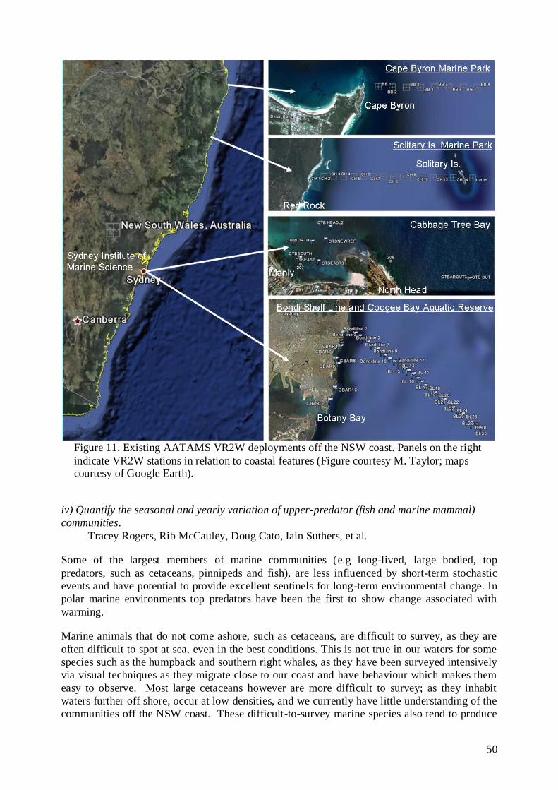
50
Figure 11. Existing AATAMS VR2W deployments off the NSW coast. Panels on the right
indicate VR2W stations in relation to coastal features (Figure courtesy M. Taylor; maps courtesy of Google Earth).
iv) Quantify the seasonal and yearly variation of upper-predator (fish and marine mammal)
communities.
Tracey Rogers, Rib McCauley, Doug Cato, Iain Suthers, et al.
Some of the largest members of marine communities (e.g long-lived, large bodied, top
predators, such as cetaceans, pinnipeds and fish), are less influenced by short-term stochastic
events and have potential to provide excellent sentinels for long-term environmental change. In
polar marine environments top predators have been the first to show change associated with
warming.
Marine animals that do not come ashore, such as cetaceans, are difficult to survey, as they are
often difficult to spot at sea, even in the best conditions. This is not true in our waters for some
species such as the humpback and southern right whales, as they have been surveyed intensively
via visual techniques as they migrate close to our coast and have behaviour which makes them
easy to observe. Most large cetaceans however are more difficult to survey; as they inhabit
waters further off shore, occur at low densities, and we currently have little understanding of the
communities off the NSW coast. These difficult-to-survey marine species also tend to produce
51
loud, characteristic, stereotyped long-range calls. This coupled with the extremely efficient
propagation of sound through the ocean sees acoustic techniques offering enormous potential to
surveying. A similar situation exists for fish choruses, a potential measure of system
productivity.
Although limited to vocalizing animals, acoustic monitoring can often detect animals at greater
distances, and while they are underwater. The passive acoustic observatories will capture
vocalisations of great whales and nearby fish at scales of km‟s (fish) to many tens of km‟s (great
whales). The passive acoustic array was designed specifically to allow source tracking for
sources which arrive coherently on all receivers. This will not only record the presence of
cetaceans and fish in the absence of visual detection but will also allow us to track animal
movements, seasonal occurrence, distribution, and behaviour, including dive and migratory
patterns, particularly with the cetaceans. These trends can then be related to larger scale physical
features for elucidation of how the physical environment impacts on the respective animal
population.
The observations required by NSW-IMOS to address its research questions are summarised in
Table 6.

52
Table 6: Observations required by NSW-IMOS
Facility Observations required by the Node
NCRIS Funded
(already allocated to Jun11)
EIF first $8M funded
(already allocated to
Jun10)
Extension of existing facility
infrastructure out to 2013.
Enhancements / new
infrastructure required 2010-
2013
ANFOG 4 x Slocum p.a.
1 x Sea Glider p.a
2-3 x Slocum p.a.
2 x Sea Glider p.a
AUV Sirius-AUV
Jervis Bay &
Coffs Harbour Study sites
Sirus-AUV benthic surveys:
1) Solitary Island (Coffs Harb);
2) Jervis Bay, Port Stephens, &
3) Batemans Marine Parks
ANMN ORS065, SYD100, SYD140,
PH100, CH070, CH100, JB070,
& ED070, NRT water samples
Passive Acoustic mooring
ADCP – NRS ORS065, SYD100, SYD140,
PH100, CH070, CH100, JB070, &
ED070, NRT water samples
Passive Acoustic mooring
Real time telemetry at SYD100.
Bio-optical sensors at the NRS
ACORN Coffs Harbour WERA Maintain Coffs Harbour array
AATAMS Transects at Sydney, Coffs
Harbour and I&I‟s SEACAMS
Transects at Sydney, Coffs
Harbour and I&I‟s SEACAMS
New arrays in Batemans Bay
(possibly Jervis Bay Marine
Parks) 20 VR2W ea
SRS SST, SSH, Colour products SST, SSH, Colour products Instrumentation for calibration of
bio-optical signals
SOOP SOOP-CPR Brisbane –
Melbourne Route
SOOP-XBT EAC lines
SOOP-CPR Brisbane – Melbourne
Route
SOOP-XBT EAC lines
Bio-acoustic monitoring of
mesozooplankton

53
5) Implementation plan – July 2009 to June 2013
The design of the observing system is based around the concept of a whole of system approach and
the ability to maximise the benefit of each of the individual measurements. We have chosen to
cluster the deployments in important regions along the coast of NSW, particular north and south of
the separation zone: Coffs Harbour, Sydney, and Bateman‟s Bay/Eden. A schematic depicting the
current and proposed infrastructure deployments are shown in Fig. 12.
Figure 12. Schematic diagram showing the location of the NSW-IMOS instrument
deployments, overlaid on a satellite image of sea surface temperature. The SST image clearly
shows the coherent EAC jet flowing poleward adjacent to the coast 30oS and producing an
eddy field further to the south (Figure M. Roughan).
54
5a) Ocean Moorings (ANMN)
Moninya Roughan, Brad Morris, et al.
The goal of the NSW-IMOS moorings sub-facility is to collect data in support of the oceanographic
needs of NSW-IMOS. This includes measurements of temperature, salinity, velocity, and
biogeochemical and bio-optical properties in the East Australian Current. We will continue the
sampling that we have implemented in the first phase of IMOS. This includes the maintenance and
delivery of data from 8 oceanographic moorings along the coast of NSW, as well as hydrographic
sampling at 4 stations along a transect off Port Hacking (Fig. 5). In-kind contribution in the form of
ORS and waverider data will also continue to be collected from our partners.
A select number of enhancements have been chosen to add value to the existing data streams. The
most important feature being the development of real time telemetry at one location (NRS).
Additionally we aim to include bio-optical sensors on our national reference station, in conjunction
with pCO2. These data will serve to create realistic subsurface light fields for modelling key
biogeochemical processes like photosynthesis, provide valuable in-situ ground truth data for
developing satellite remote sensing algorithms for ocean production and other parameters and will
significantly enhance our whole of system approach, integrating biology with physics.
The locations and details of moorings and sampling stations; current, pending and proposed, are
shown in Fig. 5, and Tables 1 and 3.
Extension 2011-2013
Continuation of existing moorings at Coffs Harbour (2), Sydney (4), Bateman‟s Bay/Eden (2);
Continuation of hydrographic sampling off Port Hacking, and maintenance of the PH100 trial
mooring;
Continuation of in-kind data (waverider and ORS data from our industry partners MHL, Sydney
Water and DECCW) being delivered to IMOS portal;
Enhancement 2009-2013
Augmentation of NRS at PH100 with velocity measurements (ADCP)
Implementation of real time telemetry at Sydney NRS
Augmentation of NRS with bio-optical sensors (Eco-triplet, FRRF)
5b) Passive acoustic mooring off NSW
Rob McCauley, Tracey Rogers, Iain Suthers, et al.
The passive acoustic observatories will be maintained by the Centre for Marine Science and
Technology (CMST) of Curtin University operating as an existing sub facility under the mooring
facility. The sea noise logging hardware is built by CMST using technology initially funded by
Australian Defence and refined over a ten year period. The NSW passive acoustic observatory (first
few years at least) consists of four moorings each with an independent receiver, with three
moorings spaced in a 3-5 km triangle and one mooring in the centre. The spatial grid will allow a
local tracking capability with range and bearing (out to approximately ten times the array
dimensions for signals coherent on all loggers) and estimation of bearing for longer range signals.
The deployment schedule for the NSW passive acoustic observatory is based on a 10 month service
interval from deployment in Feb 2010 and involves mooring servicing in Oct 2010, Aug 2011,

55
April 2012, Jan 2013 and Sept 2014. The costs of vessel charter and field logistics have been
factored in to the passive acoustic sub-facility budget.
5c) Coastal Radar (ACORN) off NSW
Moninya Roughan, Mal Heron, Brad Morris, Tim Pritchard, Ed Couriel, et al.
There are two commercial HF Radar manufacturers – WERA (German, http://ifmaxp1.ifm.uni-
hamburg.de/WERA.shtml) and CODAR (US, www.codaros.com). The WERA system which will
be deployed at Coffs Harbour in 2010-2011 provides spatial maps of surface currents, as well as
wave height, period and direction, and wind direction at hourly intervals. NSW-IMOS has a
particular interest in the WERA system to support the state‟s 7 waverider buoys – the largest wave
monitoring network in Australia. In regions where the EAC flows swiftly adjacent to the coast (e.g.
Cape Byron and the associated Marine Park) the waverider buoys at times gives conflicting data or
become submerged in strong currents. Hence in addition to the mapping of surface currents, the
wave information provided by the HF Radar system is most valuable. We propose that this radar
system remains in place at least through to the end of 2013.
We propose for future consideration by IMOS and by the NSW state government a long range HF
Radar system that covers the EAC Separation Zone to provide spatial and temporal information on
the separation of the EAC and the generation of the EAC eddy field.
5d) Ocean Gliders (ANFOG) off NSW
Iain Suthers, Mark Baird, Chari Pattiarachi, Moninya Roughan, Martina Doblin, et al.
Through 2009-2013 we will maintain 2 iRobot SeaGlider deployments of 5 months each per year in
the eddy field south of the separation zone and east of Sydney and fill-in under-sampling by ARGO
floats. We will also make cross-shelf transects of the adjacent shelf, with 2-3 Slocum gliders of 3
weeks each, when altimetry indicates it is safe to do so. Gliders will be deployed usually from
either Port Stephens or Crowdy Head in winter-spring for the East Coast Lows aim and for spring
bloom phenomena. Near real time sea level and SST images from David Griffin‟s altimetry site
(http://www.marine.csiro.au/remotesensing/oceancurrents/SNSW/latest.html) will allow strategic
deployment and navigation. Gliders are retrieved on or near the shelf using either SIMS/university
boats (<10 nautical miles), or, for longer retrievals (10-40 nautical miles), by volunteer yachts,
hired fishing vessels or by Defence Maritime Services (DMS).
Initially, glider navigation in the EAC eddy field was challenging and time consuming. However
the improved communications with SeaGliders (since Jan. 2010) has encouraged us to maintain the
two SeaGliders off NSW for 9 months pa, deploying in late summer (March), and in winter with
retrievals completed by late spring. In order to ensure lessons learnt from earlier deployments are
used by each navigator, new navigators of the NSW gliders will be assisted by earlier navigators.
Technical support is also received from the AUV facility.
5e) Autonomous Underwater Vehicle off NSW
Peter Steinberg, Stefan Williams, Maria Byrne, Will Figueira, Tim Pritchard, Alan Jordan, et
al.
Presently the AUV facility is a single ocean going Autonomous Underwater Vehicle (AUV) called
Sirius, capable of undertaking high resolution survey work. The submersible is equipped with a
56
mechanically scanned low frequency terrain-aiding sonar, a depth sensor, Doppler Velocity Log
(DVL) including a compass with integrated roll and pitch sensors, Ultra Short Baseline Acoustic
Positioning System (USBL), forward looking obstacle avoidance sonar, a conductivity/temperature
sensor and a high resolution stereo camera pair and strobes. The vehicle is controlled by an on-
board computer which is used for sampling sensor information and running the vehicle‟s low-level
control algorithms. Its capabilities are currently being expanded to measure water velocity, nitrate
concentrations and fluorescence (an indicator of biological productivity). Recently acoustic Doppler
current profilers (ADCP) have been installed in a number of autonomous vehicles and gliders with
successful results.
We will make transects to monitor long term variability of rocky reef biota (particularly kelp) in
relation to different levels of protection and hydrologic variability, especially that likely to be
associated with climate change such as temperature and pH. Initial AUV deployments will be off
Jervis Bay followed by Bateman‟s Marine Park, Coffs Harbour and Port Stephens, Great Lakes
Marine Park.
Specific deployments of the AUV off NSW may include:
1. Analysis of permanent quadrats (25 x 25m) and cross-shelf transects at 4 sites in NSW to
assess changes in deep-water kelp (exp. design consistent among states);
2. Photographic surveys of the Jervis Bay Marine Park (completed 2007);
3. Fine scale CTD surveys behind Solitary Islands (proposed);
4. Survey of fauna on key (iconic) sites such as wrecks and reefs near Bondi Beach for long
term monitoring of deep waters.
5. AUV transect data and swath mapping data from DECCW will be used to model benthic
communities at permanent survey sites
5f) Animal Tracking, (AATAMS) off NSW
Matthew Taylor, Charles Gray, David Booth, William Gladstone, Nathan Knott, Brendan
Kelaher, Rob Harcourt, Iain Suthers, et al.
The extension to mid-2013 of the existing AATAMS cross-shelf transects (curtains) and coastal
arrays of VR2W acoustic receivers (Fig. 11) is essential to implementation of research question 3v
These extensions include:
Maintenance of existing AATAMS VR2W arrays until 2013 under existing arrangements,
including AATAMS funded technical support, and in-kind contributions from NSW
DECCW, and I&I NSW (Fig. 11)
Maintenance of existing SEACAMS VR2W arrays until 2013 under existing arrangements,
including in-kind contributions from I&I NSW (Fig. 11)
Continued monitoring of existing tagged animals, which include up to 192 Vemco R-code
tags deployed during IMOS 1 on blue grouper, and grey nurse, great white, wobbygong,
dusky and bull sharks
Enhancements to the AATAMS network off the NSW coast are needed to address the science
questions, particularly around Marine Parks. Deployments of up to 40 VR2W receivers are
proposed for the NSW south coast to fill major gaps in the NSW and national AATAMS arrays
(Fig. 13), which will maximise the likelihood of detections of tagged animals migrating off the east
coast of Australia. These AATAMS lines will derive maximum benefit from the oceanographic

57
observations and minimise risk of loss of receivers due to trawling operations. Specifically,
enhancements include:
i. Deployment of new AATAMS VR2W arrays (requested in Facilities plan) in south coast
marine protected areas (Fig. 13) by August 2010, with ongoing maintenance undertaken
jointly by AATAMS funded technical support and DECCW. It is likely that only 20
VR2Ws will be deployed in Jervis Bay Marine Park, and not Batemans Bay Marine
Park.
ii. Deployment of an additional 90 VR2W moorings to augment the existing AATAMS
array funded by UNSW/SIMS/I&I NSW (Fig. 13), focusing on coastal deployments
including cross-shelf lines and gates at the mouths of estuaries as part of an ARC-
Linkage Project 2010-2013. Contracts were completed in May 2010. Coupled with
existing deployments of IMOS, DECCW and I&I NSW, this will be the largest
integrated array in Australia (>350 VR2W receivers). This $690K (cash) funded project
(ARC Linkage) will deploy 240 Vemco tags amongst migratory species including
yellowfin bream, dusky flathead and mulloway.
iii. New tag deployments undertaken in marine parks, with 20 tags deployed by February
2010 in sea mullet and yellowfin bream within Jervis Bay Marine Park (funded by
DECCW).
iv. Seals as samplers. In the future we plan to collect CTD .profiles on the continental shelf
of southern NSW using male fur seals from Montague Island (36o 15‟S) tagged with
satellite transmitting CTDs.
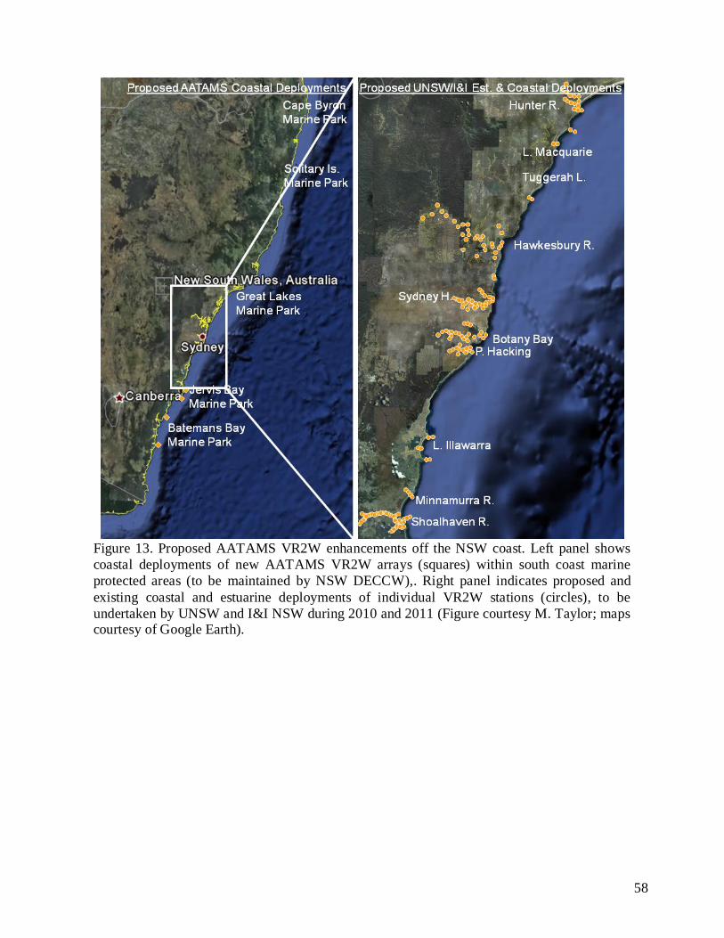
58
Figure 13. Proposed AATAMS VR2W enhancements off the NSW coast. Left panel shows
coastal deployments of new AATAMS VR2W arrays (squares) within south coast marine
protected areas (to be maintained by NSW DECCW),. Right panel indicates proposed and
existing coastal and estuarine deployments of individual VR2W stations (circles), to be
undertaken by UNSW and I&I NSW during 2010 and 2011 (Figure courtesy M. Taylor; maps courtesy of Google Earth).

59
6. How IMOS data will be taken up and used by NSW-IMOS
NSW-IMOS has over 100 members who are full time scientists, from more than 10 state and federal
institutions (Appendix 1). Between them these members have more than 30 students from honours
to post-graduate level who are using IMOS data (Appendix 2).
Other non-IMOSdata & products
Research vessel data
IMOS data & products
Pathways to uptake and use of IMOS data and products
= Australian Ocean Data
Network (AODN)
Research education &
training
Research education &
training
Research Projects
(1–3 years)
Research Projects
(1–3 years)
Research Programs (3-7 years)
Research Programs (3-7 years)
Multi-decadal analyses
Multi-decadal analyses
Research modelling systems
Research modelling systems
Operational forecasting
systems
Operational forecasting
systems
Post doc’sPhD’sPost Grad’s
ARCRDC’sDCC
CRC’sCERF Hubs
Joint venturesPartnerships
ReanalysesClimatologies
BluelinkACCESSShelf-scaleRegional
BluelinkPOAMA
nationalandinternational
via the GTS
PublicationsConference
papers, posters
Research reports
Analyses, products
Validation, assimilation
Remote sensing
products
Remote sensing
products
SSTAltimetry
Ocean Colour
Figure. 14 Pathways to the uptake and use of IMOS data, showing the balance of research
projects underpinning long term observations.
Impact and delivery through improving model output
The results from Research Questions 1 and 2 will support ocean, meteorological and climate
numerical model simulations including hindcasts and forecasts from models such as BLUElink and
SEAROMS. We have made it a node priority to provide as many of the data streams as possible in
near real time such that these data can readily be ingested into forecasting models of the ocean and
atmosphere. This is particularly necessary for the mooring and HF radar data. The Tasman Sea
region has typically been difficult to model due to the large variability in the mesoscale eddy field.
RMS error in the BLUElink model is greatest off southeastern Australia where NSW-IMOS has
deployed significant infrastructure. Furthermore large scale models do not perform well on the
continental shelf region hence coastal observations (particularly from HF radar) are essential. The
vertical profiles of bio-optical data available from glider deployments provide a newly available
resource for assessment of ecosystem models that has not previously been available. This is an

60
emerging and powerful method of ecosystem model assessment (Fujii et al., 2007). The
meteorological measurements at the air-sea interface will contribute to numerical weather
prediction models, which will have the benefit of improved early warning systems particularly
during storm events.
Ensuring the data are used
With the large number of active node members and we are confident that the IMOS data will be
used. In recent years a number of the members of NSW-IMOS have received competitive ARC
grants that are built around IMOS data streams. Each of these proposals alone will go a long way to
ensuring that the data are used. The proposals which make use of NSW-IMOS data include (but are
not limited to) those in Table 7. Importantly the majority of the proposals have been funded for
research commencing in either 2009 or 2010 highlighting the fact that these are new proposals
focussed on research questions pertinent to NSW-IMOS.
Table 7. Currently funded projects using NSW-IMOS data streams.
Principle Investigators and
Timeframe
Project Title Funding Type
Hassler and Doblin et al. (2010-2012) Novel technologies to resolve the role
of organic matter on Fe chemistry and
bioavailability in the South Pacific
Ocean.
ARC Discovery
Heron, Banner, Wyatt (2009-2012) Wave climate in the Southern Great
Barrier Reef.
ARC Linkage
Pizarro, Williams, Jakuba, Eustice,
Whitcomb (2010-2014)
Cost effective autonomous systems for
large scale monitoring of marine
protected areas.
ARC Discovery
Steinberg et al., (2010-2012) Stress, virulence and bacterial disease
in temperate seaweeds: the rise of the
microbes.
ARC Discovery
Suthers and Baird (2008-2010) Quantifying the role of salps in marine
food webs and organic carbon export.
ARC Discovery
Suthers and Oke (2009-2011) Coastal cold core eddies of the East
Australian Current and their fisheries
potential.
ARC Discovery
Suthers, Richardson, Swadling, Ralph,
Taylor, Doblin, Virtue. (2010)
A Laser Optical Plankton Counter for
laboratory and in-situ size
distributions of zooplankton, to assess
the basis and outcomes of changing
ecosystems
ARC Large
Infrastructure &
Equipment Fund
with UQ, UTS,
UTas.
LE100100204
Taylor, Suthers, Booth and Gray
(2010-2012)
Feeding and breeding: Rainfall effects
on connectivity and fidelity of iconic
coastal fishes.
ARC Linkage
Waite and Roughan et al. (2010-2012) Ocean reef interactions as drivers of
continental shelf productivity in a
changing climate.
ARC Discovery

61
Turner et al. (2010 – 2013) Australian coastal observation
network: monitoring and forecasting
coastal erosion in a changing climate.
ARC Linkage
Ajani 2010.
Phytoplankton diversity in coastal
waters of New South Wales, Australia.
Australian
Biological
Resources Study
Capacity-
Building Grant.
Ajani 2010 Phytoplankton patterns in the coastal
waters of New South Wales, Australia
for the period 2010-2013.
NSW Food
Authority.
Stefan Williams, Maria Byrne, Will
Figueira Neville Barrett and
Machine assisted- Multi-scale Spatial
and Temporal Observation and
Modeling of Marine Benthic Habitats.
Super Science
Fellowship
2010, U.Syd,
UTas
Gales, Nicol, Hindell, Harcourt (UTas,
AAD, Macqu U)
Pelagic ecosystem linkages in a
changing Southern Ocean
Super Science
Fellowship 2010
Johnson, Holbrook, Barrett, Steinberg. Effects of climate change on
temperate benthic assemblages on the
continental shelf in eastern Australia
Super Science
Fellowship
2010, UTas,
UNSW
Stefan Williams Autonomous Exploration and
Characterization of Benthic Habitats
Linked to Oceanographic Processes
ARC-Discovery
2008-2010
Stefan Williams, Oscar Pizarro,
Jakuba,
Autonomous repeatable surveys for
long term monitoring of marine
habitats
ARC Linkage
2010-2013
Johnson, Barrett, Steinberg, Babcock East Coast Kelp Habitat Mapping Super Science
Fellowship 2010
Edgar, Stuart-Smith, Booth, Jordan,
Ayre, Waters, O‟Hara, Poore
Biotic connectivity within the
temperate Australian marine protected
area network at three levels of
biodiversity, communities,
populations and genes.
ARC Linkage
2010-2015
Additionally, the NSW state government has committed $600K to salaries for NSW-IMOS. Two
SIMS partners were also successful with 2 Super Science Initiative fellowships. NSW-IMOS has
initiated a special issue on the East Australian Current in Deep Sea Research – Part II (edited by
Suthers, Roughan, Young, Baird and Ridgway). From 37 abstracts submitted on 20 March 2009, 17
papers will be published by late 2010, early 2011. A number of the papers submitted involve
analysis of IMOS data. Papers that make use of IMOS data are identified below.
62
Recently published Papers from NSW IMOS node members that use IMOS data
1) Baird, M.E., Everett, J.D., Suthers, I.M., In Press. Analysis of southeast Australian
zooplankton observations of 1938-42 using synoptic oceanographic conditions. Deep Sea
Research, Part II.
2) Baird, M. E., I. M. Suthers, D. A. Griffin, B. Hollings, C. Pattiaratchi, J. D. Everett, M.
Roughan, K. Oubelkheir and M. Doblin. In Press. The effect of surface flooding on the
physical-biogeochemical dynamics of a warm core eddy off southeast Australia. Deep Sea
Research, Part II.
3) Barkby, S.A., Williams, S.B., Pizarro, O. & Jakuba, M. 2009. An efficient approach to
bathymetric SLAM. Proceedings of the IEEE/RSJ International Conference on Intelligent
Robots and Systems, pp. 2525-2530, St Louis, USA, October 2009.
4) Bridge, T., Done, T., Beaman, R., Friedman, A., Williams, S.B., Pizarro, O., Webster, J.
2010. Topography, substratum and benthic macrofaunal relationships on a tropical
mesophotic shelf margin, Great Barrier Reef, Australia. Coral Reefs, (in review).
5) Byrne 2009 Flashing stars light up subaqueous dunes off the Great Barrier Reef. ECOS 28
150-151
6) Brassington, G. B., N. Summons and R. Lumpkin, In Press. Observed and simulated
Lagrangian and eddy characteristics of the East Australian Current and Tasman Sea. Deep
Sea Research, Part II.
7) Condie, S.A., Mansbridge, J.V., Cahill, M.L., In Press. Contrasting local retention and
cross-shore transports of the East Australian Current and the Leeuwin Current and their
relative influences on the life histories of small pelagic fishes. Deep Sea Research, Part II.
8) Hassler CS, Djajadikarta JR, Doblin MA, Everett JD, Thompson PA., In Press.
Characterisation of water masses and phytoplankton nutrient limitation in the East
Australian Current separation zone during spring 2008. Deep Sea Research, Part II.
9) Holbrook, N. J., I. D. Goodwin, S. McGregor, E. Molina, and S. B. Power, 2010. ENSO to
multi-decadal time scale changes in East Australian Current transports and Fort Denison sea
level: Oceanic Rossby waves as the connecting mechanism. Deep-Sea Research II.
10) Holbrook, N. J., 2010: South Pacific Ocean dynamics: potential for enhancing sea level and
climate forecasts. Chapter 10 in: „Climate Alert: Climate Change Monitoring and Strategy‟,
eds. Y. You and A. Henderson-Sellers, Sydney University Press, pp.313-342, ISBN 978-1-
920899-41-7.
11) Holbrook, N. J., J. Davidson, M. Feng, A. J. Hobday, J. M. Lough, S. McGregor, and J. S.
Risbey, 2009: Chapter 4: El Niño – Southern Oscillation. In Report Card of Marine Climate
Change for Australia: detailed scientific assessment, Eds. E. S. Poloczanska, A. J. Hobday
and A. J. Richardson, NCCARF Publication 05/09, pp.29-51, ISBN 978-1-921609-03-9.
12) Johnson-Roberson, M., O. Pizarro, S.B. Williams, I. Mahon, 2010. Generation and
Visualization of Large Scale 3D Reconstructions from Underwater Robotic Surveys, Journal
of Field Robotics, 27(1):21-51.
13) Maharaj, A. M., P. Cipollini, N. J. Holbrook, P. D. Killworth and J. R. Blundell, 2007. An
evaluation of the classical and extended Rossby wave theories in explaining spectral
estimates of the first few baroclinic modes in the South Pacific Ocean. Ocean Dynamics,
57(3), 173-187. DOI 10.1007/s10236-006-0099-5.
14) Maharaj, A. M., N. J. Holbrook and P. Cipollini, 2009. Multiple westward propagating
signals in South Pacific sea level anomalies. Journal of Geophysical Research – Oceans,
114 (C12016) pp. 1-14.

63
15) Mahon, S.B. Williams, O. Pizarro and M. Johnson-Roberson, 2008. Efficient View-Based
SLAM Using Visual Loop Closures, Robotics, IEEE Transactions on, 24(5):1002-1014.
16) Malcolm, H.A., Davies, P.L., Jordan, A., Smith, S.D.A. In Press. Variation in sea
temperature and the East Australian Current in the Solitary Islands region between 2001-
2008. Deep Sea Research, Part II.
17) Oke, P.R., Griffin, D.A. In Press. The cold-core eddy and strong upwelling off the coast of
New South Wales in early 2007. Deep Sea Research, Part II.
18) Rao, D., Williams, S.B. 2009. Large-scale path planning for underwater gliders in ocean
currents. Proceedings of the 2009 Australasian Conference on Robotics and Automation, 8
pp., Sydney, Australia, December 2009.
19) Rigby, P., O. Pizarro and S.B. Williams 2007. Improved AUV navigation through multi-
sensor data fusion, Sea Technology, 48(3), pages 15-22.
20) Rigby, P., Williams, S.B., Pizarro, O. 2010. Towards Adaptive Benthic Habitat Mapping
using Gaussian Process Classification. Journal of Field Robotics, (in review).
21) Roughan, M., Macdonald H.S., Baird, M.E., Glasby, T.M., In Press. Modelling seasonal and
interannual variability in a Western Boundary Current and its impact on coastal
connectivity. Deep Sea Research, Part II.
22) Roughan, M., Morris, B.D., Suthers, I. 2010. NSW-IMOS: An Integrated Marine Observing
System for Southeastern Australia. 2010 IOP Conf. Ser.: Earth Environ. Sci., 11, 012030.
23) Roughan, M., I. Suthers, I., G. Meyers, 2010. The Australian Integrated Marine Observing
System and the regional implementation in New South Wales.Chapter 9 Climate Alert
Sydney University Press ISBN 9781920899363.
24) Steinberg, D., Bender, A. Friedman, A., Jakuba, M., Pizarro, O., Williams, S.B. 2010.
Analysis of propulsion methods for long range AUVs. Marine Technology Society Journal,
44(2):46-55.
25) Suthers, Young, Baird, Roughan, Everett, Brassington, Byrne, Condie, Hartog, Hassler,
Hobday, Holbrook, Malcolm, Oke, Thompson, and Ridgway, In Press. The strengthening
East Australian Current, its eddies and biological effects – an introduction and overview to
the special issue. Deep Sea Research, Part II.
26) Syahailatua, A., Roughan, M., Suthers, I.M., In Press. Characteristic ichthyoplankton taxa in
the separation zone of the East Australian Current: larval assemblages as tracers of coastal
mixing. Deep Sea Research, Part II.
27) Syahailatua, A., Taylor, M.D., Suthers, I.M., In Press. Growth variability and stable isotope
composition of two larval carangid fishes in the East Australian Current: The role of
upwelling in the separation zone. Deep Sea Research, Part II.
28) Thompson, P.A. Baird, M.E., Ingleton, T., Doblin, M.A., 2009. Long-term changes in
temperate Australian coastal waters and implications for phytoplankton. Marine Ecology
Progress Series (in press).
29) Thompson, P.A. Bonham, P. Waite A.M. Clementson, L.A. Cherukuru, N. Doblin, M.A., In
Press. Contrasting oceanographic conditions and phytoplankton communities on the east and
west coasts of Australia. Deep Sea Research, Part II.
30) Webster, J., R. Beaman, T. Bridge, P. Davies, M. Byrne, S.B. Williams, P. Manning, O.
Pizarro, K. Thornborough, A.A. Thomas, and S. Tudhope, S. 2008. From corals to canyons:
The great barrier reef margin. EOS, Transactions American Geophysical Union,
89(24):217–218.

64
31) Woolsey, E, Byrne, M, Williams, Pizarro, O, Thronborough K, Davies, P, Beaman R,
Webster, J., Bridge T. Ophiopsila pantherina beds on subaqueus dunes off the Great
Barrier Reef. In. C. Johnson et al. Echinoderms, Hobart, CRC Press, Boca Raton
32) Williams, S.B., I. Mahon, 2006. Terrain Aided Localisation and Mapping for Marine
Environments, in M. Ang and O. Khatib, editors, Springer Tracts in Advanced Robotics,
Vol. 21, pages 111 - 120.
33) Williams, S.B., O. Pizarro, M. Jakuba & N. Barrett. 2009. AUV benthic habitat mapping in
south eastern Tasmania. Proceedings of the 7th International Conference on Field and
Service Robotics, 10 pp., Cambridge, USA, July 2009.
34) Williams, S.B., O. Pizarro, M. Jakuba, I. Mahon, S.D. Ling & C.R. Johnson. 2010. Repeated
AUV surveying of urchin barrens in North Eastern Tasmania. Proceedings of the IEEE 2010
International Conference on Robotics and Automation, pp 293 - 299, Anchorage, USA, May
2010.
35) Williams, S.B., O. Pizarro, I. Mahon and M. Johnson-Roberson, 2008. Simultaneous
Localisation and Mapping and Dense Stereoscopic Seafloor Reconstruction using an AUV,
in G. Pappas, V. Kumar and O. Khatib, Springer Tracts in Advanced Robotics, Vol. 54,
pages 407-416.
36) Williams, S.B., O. Pizarro, J.M. Webster, R.J. Beman, I. Mahon, M. Johnson-Roberson, T.
Bridge, submitted. AUV-assisted surveying of drowned reefs on the shelf edge of the Great
Barrier Reef, Australia, Journal of Field Robotics, 27(5):675-697.
Partnering for sustained ocean observing
SIMS is a collaboration of the four main universities in Sydney, The University of New South
Wales, including UNSW@ADFA, University of Technology Sydney, University of Sydney and
Macquarie University. Hence by its nature, SIMS is a collaborative institute. Over the past few
years SIMS has grown from strength to strength, and this is reflected in the list of associate
members who have joined SIMS including University of Wollongong, University of Western
Sydney, Defence Science and Technology Organisation (DSTO), NSW-DECCW, II NSW and The
Australian Museum.
Many of the infrastructure proposals submitted in this current round of funding carry significant
support from our industry partners including Sydney Water Corporation, Defence Maritime
Services, thus giving at least a dollar for dollar return on investment. Partnering with the NSW
state departments will grow as we make the science (observations) and data products relevant to
state agencies. As a priority, IMOS data needs to be used to show the linkages between blue water
and shelf oceanography to near-shore state concerns in the form of a National Coastal Observing
System.

65
7. Describe what impact the IMOS observations will have regionally, nationally
and globally:
7-1) Identify the issues and problems on which the Node will have the greatest impact over the next
5 years.
Our greatest impacts will be on the physical and ecological interactions of the East Australian
Current with coastal waters, in determining the synergistic impacts of urbanization and climate
change. We expect the greatest impact from NSW-IMOS will be in the areas of:
Understanding of cross-shelf flows, deep water intrusions and plankton and microbial
diversity and their relationship to past observations and predicted changes.
Continued development of ocean circulation models particularly over the continental shelf
region, ranging from hindcasting, nowcasting and forecasting.
Improved data products for assimilation into and verification of ocean, wave, climate and
weather prediction models.
Enhanced models of biophysical coupling through enhanced measurement of mechanistic
parameters driving biological variability (e.g. light) and via mapping of biological parameters onto
the physical variability of the EAC.
Prediction of climate change impacts on sediment transport, storm surge, coastal erosion and
inundation.
Estimates of larval connectivity along the coast of southeastern Australia, amongst ports,
harbours as well as among marine parks; planning for marine parks;
Improved predictions of fish landings based on rainfall and oceanographic variation
Validating contemporary ocean colour derived estimates of chlorophyll, CDOM and TSS
against direct IMOS observations
Developing NSW specific optical inversion algorithms for near shore, optically complex
coastal waters.
Parameterization of future linked ecosystem models and the evaluation of forecasting
abilities through the collection of biological and geochemical data streams.
7-2) Identify the strategic issues and problems that IMOS will address if sustained in the longer
term.
The strategic issues and problems are related to extending IMOS data and knowledge into the near
shore. In the future we will particularly need knowledge of urbanization (which shall continue
unabated along the eastern seaboard) to assess climate change effects. We will have a legacy of
talent and data before severe climate impacts are evident.
Aside from the waverider buoy records along the NSW and SE Qld coast, the observational wave
record is inadequate for resolving past changes in wave climate. Large spatial gaps in directional
data allow little to no comment on the directional response of the wave climate to shifts in wave
climate, which are suggested by global wave models.
Greater effort is required in making statistical and dynamical projections of Australian wave climate
under future climate scenarios. Increased statistical certainty is achieved through averaging
projections from a larger range of Global Climate Models emissions scenarios, and solution

66
ensembles. Such projections are required over all coastal regions of Australia. Currently, the ability
to carry out such projections is restricted by the availability of forcing data of sufficient temporal
and spatial resolution from global climate models.

67
8. Governance, structure and funding:
The Sydney Institute of Marine Science (SIMS) hosts the NSW node of IMOS (NSW-IMOS). As
the host organisation and the operator of 3 facilities (see below), SIMS is investing substantially in
IMOS, (~$1.25 M cash) including $15,000 cash per year for running the node. The NSW
government has also co-invested in NSW-IMOS with $600,000 to fund 3 personnel to mid 2013.
SIMS is the designated operator of two IMOS facilities and one sub-facility, these being:
The autonomous underwater vehicle facility (AUV, led by Dr Stefan Williams),
The Australian Acoustic Tracking and Monitoring System (AATAMS, led by Prof Rob
Harcourt) and
The NSW sub-facility of the Australian National Mooring Network (ANMN led by Dr
Moninya Roughan).
Membership
The membership of NSW-IMOS is open to anyone with a professional interest in ocean
observations along the coast of NSW. It will have no restriction other than a willingness to be
enrolled on a membership database. Presently NSW-IMOS has over 100 members who are full time
scientists, from over 10 state and federal institutions (Appendix 1). Node priorities are set through
consultation with the NSW-IMOS community via public meetings (twice per annum) and
distributing all significant documents by email to the membership list. The node has a scientific
reference group led by Prof Iain Suthers (node leader to Sept 2010) and Dr Moninya Roughan with
Dr. Martina Doblin (co-leader from Sept. 2010). The Governance structure for NSW-IMOS is
shown in Fig. 15.
Figure 15. Diagram showing governance of NSW-IMOS from Sept 2010. NB Suthers was node leader prior to September 2010.

68
How the stakeholders will be engaged including indicative levels of co-investment
We have held biannual node meetings at SIMS since Feb. 2007, attracting 40-50% of members:
Meeting # Date Agenda
1 Feb. 2007 Formation and governance of NSW-IMOS
2 24 Sept. 2007 1) To summarise the activities and plans of the 3 facilities
based at SIMS (AUV, AATAMS, Moorings)
2) To plan our applications for the IMOS mobile elements - the
AUV, the High Frequency coastal radar (ACORN) and the ocean glider. Due on 17 Nov 2007.
3 5 Aug 2008 NSW IMOS update - Key note address: Andreas Schiller
(CMAR) “BLUELink and NSW IMOS”
4 10 Nov 2008 NSW IMOS update - Key note address: George Cresswell on the EAC and preparation for a special issue in DSR-II
5 30 April 2009 “LOOKING FORWARD – an integrated coastal observing
system 2011-16”
To outline a 2 page scoping paper for the IMOS office on the science needs and infrastructure for NSW for beyond 2011
6 29 September, 2009 Review the revised Node Science & Implementation Plan for
the new EIF funding
7 19 May 2010 Update and outcomes of EIF decision process
8 22 September 2010 Key note address Tom Malone - Coastal ocean observing
systems
The following industry partners are engaged in NSW-IMOS through the node community meetings,
shared grants and joint publications. They also provide financial and logistical support to NSW-
IMOS. Their indicative levels of co-investment are listed in each of their letters of support supplied
to the facilities.
Department of Environment, Climate Change and Water (DECCW)
Contact: Mr Tim Pritchard
Port Hacking NRS transect sampling
Waverider buoy network data
AATAMS receivers
In-kind support (boats, time)
Innovation and Industry (II NSW)
Contact: Dr Charles Gray
SEACAMS (70 VR2W receiver network)
AATAMS receivers
Manly Hydraulics Laboratory (DSTA)
Contact: Dr Ed Couriel

69
In–kind support
Sydney Water Corporation
Contact: Dr Peter Tate
Ocean Reference Station data
Oceanographic Field Services
Contact: Mr Clive Holden
In-kind support
NSW-Office for Medical and Scientific Research
Contact: Mr Chris Armstrong
In-kind support
Defence Science & Technology Organisation (DSTO)
Contact: Dr Doug Cato
In-kind support
Defence Maritime Services
Contact Mr Mark Todd
In-kind support - boats

70
9. References
ABARE 2007, Australian Fisheries Statistics 2006, Canberra June. ISSN 1037-6879
Achtman M, Wagner M. 2008. Microbial diversity and the genetic nature of microbial species. Nat Rev Microbiol.,
6(6), 431-440.
Ajani, P. A., Lee, R. S., Pritchard, P. R., Krogh, M., 2001. Phytoplankton patterns at CSIRO‟s long-term coastal station
off Sydney, Australia. J. Coastal Res. 34, 60–73.
Ajani, P., Armand, L., Ingelton, T., and Pritchard, T. in prep/submit. Microalgal blooms in the coastal waters of New
South Wales, Australia: a decadal shift in observational data and its relation to climate variability.
Anonymous 2007. East Marine Planning Region. Non-fisheries resource use activities in the east marine planning
region. Sinclair Knight Mertz report to DEWR.
http://www.environment.gov.au/coasts/mbp/publications/general/marine-economic.html
Babcock RC, Kelly S, Shears NT, Walker JW. 1999. Changes in community structure in temperate marine reserves.
Marine Ecology Progress Series 189:125-134
Baines, P. G., 1986. Internal tides, internal waves, and near-inertial motions, in Baroclinic Processes on Continental
Shelves, Coastal and Estuarine Science 3, edited by C. N. K. Mooers, AGU, Washington, D.C., 19-31 pp.
Baird, M.E. and Suthers, I.M., 2007. A size-resolved pelagic ecosystem model. Ecological Modelling, 203(3-4): 185-
203.
Baird, M. E., Timko, P. G., Middleton, J. H., Mullaney, T. J., Cox, D. R., Suthers, I. M., 2008. Biological properties
across the Tasman Front off southeast Australia. Deep-Sea Research Part I: Oceanographic Research Papers 55 (11),
1438–1455.
Baird, M. E., I. M. Suthers, D. A. Griffin, B. Hollings, C. Pattiaratchi, J. D. Everett, M. Roughan, K. Oubelkheir and M.
Doblin, 2010. The effect of surface flooding on the physical-biogeochemical dynamics of a warm core eddy off southeast Australia. Deep Sea Research II, (in press).
Banks, S.C., Piggott, M.P., Williamson, J.E., Bove, U., Holbrook, N.J., Beheregaray, L.B., 2007. Oceanic variability
and coastal topography shape genetic structure in a long-dispersing sea urchin. Ecology, 88(12), 2007, 3055–3064
Booth, D.J., Figueira, W.F., Gregson, M.A., Brown, L. and Beretta, G., 2007. Occurrence of tropical fishes in temperate
southeastern Australia: Role of the East Australian Current. Estuarine Coastal and Shelf Science, 72(1-2): 102-114.
Botsford, L.W., Micheli, F., Hastings, A. 2003. Principles for the design of marine reserves. Ecological Applications
,13, S25-S31.
Bowen M.M., Wilkin J.L., Emery, W.J. 2005. Variability and forcing of the East Australian Current. J. Geophys. Res.,
110, C03019.
Bruce, B.D., Stevens, J.D. and Malcolm, H., 2006. Movements and swimming behaviour of white sharks (Carcharodon
carcharias) in Australian waters. Marine Biology, 150(2): 161-172.
Cai, W., Shi, G., Cowan, T., Bi, D., Ribbe, J., 2005. The response of the Southern Annular Mode, the East Australian
Current, and the southern mid-latitude ocean circulation to global warming. Geophys. Res. Letters 32, L23706,
doi:10.1029/2005GL024701.
Chapman, D.M., Geary, M., Roy, P.S. and Thom, B.G., 1982. Coastal Evolution and Coastal Erosion in New South
Wales: A report prepared for the Coastal Council of New South Wales. Coastal Council of New South Wales, 1982.
Coleman MA, Vytopil E, Goodsell PJ, Gillanders BM and Connell SD, 2007. Depth and mobile invertebrates: evidence
of a widespread pattern in biodiversity. Aust. J. Mar. FW. Res. 58: 589-595.
Coleman MA, Kelaher BP, Steinberg PD & Miller, A.J., 2008. Phyllospora lost: massive decline of an important
habitat-forming alga on urbanised rocky reefs around Sydney, Australia J. Phycol. 9:1015-1017
Cresswell, G. R., 1974. Ocean currents measured concurrently on and off the Sydney area continental shelf. Aust. J.
Mar. Freshw. Res. 25, 427–38.

71
Cresswell, G. R., 1976. A drifting buoy tracked by satellite in the Tasman Sea. Aust. J. Mar. Freshw. Res. 27 (2), 251–
262.
Cresswell, G.R., 1983. Physical Evolution of Tasman Sea Eddy-J. Australian Journal of Marine and Freshwater
Research, 34(4): 495-513.
Cresswell, G., 1994. Nutrient enrichment of the Sydney Continental shelf. Australian Journal of Marine and Freshwater
Research, 45: 677-691.
Cresswell, G. R., Ellyett, C., Legeckis, R., Pierce, A. F., 1983. Nearshore features of the East Australian Current
system. Aust. J. Mar. Freshw. Res. 34, 105–114.
Dela-Cruz, J., J. H. Middleton, and I. M. Suthers. 2003. „Population growth and transport of the red tide dinoflagellate,
Noctiluca scintillans, in the coastal waters off Sydney Australia, using cell diameter as a tracer‟. Limnology and
Oceanography 48(2):656-674.
Dela-Cruz, J., Middleton, J.H. and Suthers, I.M., 2008. The influence of upwelling, coastal currents and water
temperature on the distribution of the red tide dinoflagellate, Noctiluca scintillans, along the east coast of Australia.
Hydrobiologia, 598: 59-75.
Doblin, M.A., Petrou, K.L., Shelly, K., Westwood, K., van den Enden, R., Wright, S., Griffiths, B., Ralph, P.J. (2010)
Diel variation of chlorophyll-a fluorescence, phytoplankton pigments and productivity in the Sub Antarctic and
Polar Front zones south of Tasmania, Australia. Accepted in Deep Sea Res. 18 August 2010.
Edgar, G.J. 1983. The ecology of south-east Tasmanian phytal animal communities. III. Patterns of species diversity. J.
Exp. Mar. Biol. Ecol. 70: 181-203.
Edgar, G.J. 1984. General features of the ecology and biogeography of Tasmanian subtidal rocky shore communities.
Pap. Proc. Royal Soc. Tas. 118: 173-186.
Egbert, G. D., and R. D. Ray, 2001. Estimates of M2 tidal energy dissipation from TOPEX/Poseidon altimeter data, J.
Geophys. Res., 106, 22,475-22,502.
Figueira W.F., Booth, D.J., 2010. Increasing ocean temperatures allow tropical fishes to survive overwinter in
temperate waters. Global Change Biology, 16, 506-516.
Fujii, M., Boss, E., and Chai, F. 2007. The value of adding optics to ecosystem models: a case study, Biogeosciences, 4,
817-835.
Gaston, T.F., Kostoglidis, A. and Suthers, I.M., 2004. The C-13, N-15 and S-34 signatures of a rocky reef planktivorous fish indicate different coastal discharges of sewage. Marine and Freshwater Research, 55(7): 689-699.
Gibbs, M. T., J. H. Middleton, and P. Marchesiello. 1998. „Baroclinic response of Sydney shelf waters to local wind
and deep ocean forcing‟. Journal of Physical Oceanography 28:178-190.
Gillanders B.M., Kingsford, M.J., 2002. Impact of changes in flow of freshwater on estuarine and open coastal habitats
and the associated organisms. Oceanography and Marine Biology 40: 233-309
Gillson J, J Scandol, IM Suthers. 2009 Estuarine gillnet fishery catch rates decline during drought in eastern Australia.
Fisheries Research 99: 26-37
Gladstone, W., 2007. Requirements for marine protected areas to conserve the biodiversity of rocky reef fishes. Aquat.
Conserv.: Mar. Freshwat. Ecosyst., 17(1), 71-87.
Godfrey, J. S., Cresswell, G. R., Boland, F. M., 1980a. Observations of low Richardson Numbers and undercurrents
near a front in the East Australian Current. J. Phys. Oceanogr. 10, 301–307.
Godfrey, J. S., Cresswell, G. R., Golding, T. J., Pierce, A. F., 1980b. The separation of the East Australian Current. J.
Phys. Oceanogr. 10, 430–440.
Graham MH, Kinlan BP, Druehl LD, Garske LE , Banks S. 2007. Deep-water kelp refugia as potential hotspots of
tropical marine diversity and productivity. PNAS 104: 16576-16580.
Grant, B. R., 1971. Variation in silicate concentration at Port Hacking station, Sydney, in relation to phytoplankton
growth. Australian Journal of Marine and Freshwater Research, 22, 49-54.
72
Grant, B. R. and Kerr, J. D. 1970. Phytoplankton numbers and species at Port Hacking station and their relationship to
the physical environment. Australian Journal of Marine and Freshwater Research, 21, 35-45.
Griffin, D.A. and Middleton, J.H., 1992. Upwelling and internal tides over the inner New South Wales continental
shelf. Journal of Geophysical Research, 97: 14389-14405.
Griffiths, F.B., Wadley, V.A. 1986. A synoptic comparison of fishes and crustaceans from a warm-core eddy, the East
Australian Current, the Coral Sea and the Tasman Sea. Deep-Sea Research 33:1907-1922
Gwynne, H.L., 1994. Management of recreational fishing in Queensland. In 'Recreational fishing: what's the catch'. (Ed.
DA Hancock) pp. 220-223. (Australian Society for Fish Biology: Canberra)
Hahn, S. D., Rochford, D. J. and Godfrey, J. S., 1977. Long-term variability of oceanographic data at the Port Hacking
50-metre station. Australian Journal of Marine and Freshwater Research, 28, 57-66.
Hallegraeff, G. M., 1981. Seasonal study of phytoplankton pigments and species at a coastal station off Sydney,
Marine Biology, 61, 107-118.
Hallegraeff, G. M., 1993. Assessment of the Impact of Algal Blooms on the Water Quality of Sydney Coastal Waters.
Report to the Sydney Water Board, University of Tasmania, Hobart, 49p.
Hallegraeff, G. M., Jeffrey, S. W., 1993. Annually recurrent diatom blooms in spring along the New South Wales coast
of Australia. Aust. J. Mar. Freshw. Res. 44, 325–34.
Hallegraeff, G. M. and Reid, D. D., 1986. Phytoplankton species successions and their hydrological environment at a coastal station off Sydney. Australian Journal of Marine and Freshwater Research, 37, 361-377.
Hamon, B. V., 1965. The East Australian Current 1960-1964. Deep Sea Res. 12, 899–921.
Hamon, B. V., 1968. Temperature structure in the upper 250 metres in the East Australian Current area. Aust. J. Mar.
Freshw. Res. 19, 91–99.
Henry, G.W., Lyle, J.M., 2003. 'The national recreational and indigenous fishing survey.' Australian Government
Department of Agriculture, Fisheries and Forestry, Canberra.
Hill, K.L., Rintoul, S.R., Coleman, R., Ridgway, K.R., 2008. Wind forced low frequency variability of the East
Australian Current. Geophys. Res. Lett. 35, L08602.
Hobday, A.J., Hartmann, K. 2006. Near real-time spatial management based on habitat predictions for a longline
bycatch species. Fisheries Management and Ecology, 13 (6). pp. 365-380.
Holbrook, N. J., 2010. South Pacific Ocean dynamics: potential for enhancing sea level and climate forecasts. Chapter
10 in: „Climate Alert: Climate Change Monitoring and Strategy‟, eds. Y. You and A. Henderson-Sellers. Sydney
University Press, pp.313-342, ISBN 978-1-920899-41-7.
Holbrook, N. J. and N. L. Bindoff, 1997. Interannual and decadal temperature variability in the southwest Pacific Ocean
between 1955 and 1988. Journal of Climate, 10, 1035-1049.
Holbrook, N. J., I. D. Goodwin, S. McGregor, E. Molina, and S. B. Power, 2010. ENSO to multi-decadal time scale
changes in East Australian Current transports and Fort Denison sea level: Oceanic Rossby waves as the connecting
mechanism. Deep Sea Research II, (in press).
Holbrook, N. J. and A. M. Maharaj, 2008. Southwest Pacific subtropical mode water: A climatology. Progress in
Oceanography, 77, 298-315.
Holland G.J., Lynch A.H., Leslie L.M. 1987. Australian east-coast cyclones. Part I: Synoptic overview and case study.
Mon.Wea. Rev., 115, 3024-36.
Holloway, P. E., Merrifield, M.A., 1999. Internal tide generation by seamounts, ridges, and islands, J. Geophys. Res., 104, 25,937-25,951.
Hopkins, L.C., Holland, G.J. 1997. Australian heavy-rain days and associated east coast cyclones: 1958-92. J. Climate,
10, 621-635.
Humphrey, G. F., 1960. The concentration of planktonic pigments in Australian waters, CSIRO Division of Fisheries
and Oceanography Technical Paper No. 9, 27p.

73
Humphrey, G. F., 1963. Seasonal variations in plankton pigments in waters off Sydney. Australian Journal of Marine
and Freshwater Research, 14, 1, 24-36.
Jacobs, G.A., Woodham, R., Jourdan, D. and Braithwaite, J. 2009. GODAE applications useful to Navies throughout
the world. Oceanography, 22(3): 182-189.
Jeffrey, S.W. and Carpenter, S. M., 1974. Seasonal succession of phytoplankton at a coastal station off Sydney.
Australian Journal of Marine and Freshwater Research, 25, 361-369.
Kasai, A., Kimura, S., Nakata, H., Okazaki, Y. 2002. Entrainment of coastal water into afrontal eddy of the Kuroshio
and its biological significance. Journal of Marine Systems, 37(1-1), 185-198.
Kingsford, M. J. and I. M. Suthers, 1994. Dynamic Estuarine Plumes and Fronts - Importance to Small Fish and
Plankton in Coastal Waters of NSW, Australia. Continental Shelf Research 14(6): 655-672.
Kingsford, M. J., and I. M. Suthers. 1996. The influence of tidal phase on patterns of ichthyoplankton abundance in the
vicinity of an estuarine front, Botany Bay, Australia. Estuarine Coastal and Shelf Science 43:33-54.
Kulmar, M., Lord, D., Sanderson, B. 2005. Future Directions for Wave Data Collection in New South Wales [online].
In: Coasts and Ports: Coastal Living – Living Coast; Australasian Conference 2005; Proceedings; pages: 167-172.
Townsend, Murray Robert (Editor); Walker, David (Editor). Barton, A.C.T.: Institution of Engineers, Australia,
2005. Availability: ISBN: 0646451308.
Leslie LM, Holland GJ & Lynch AH. 1987. Australian east-coast cyclones. Part II: Numerical modelling study. Mon.
Wea. Rev., 115, 3037-53.
Ling, S.D. 2008. Range expansion of a habitat-modifying species leads to loss of taxonomic diversity: a new and
impoverished reef state. Oecologia 156: 883-894.
Ling , S.D., Johnson, C.R., Ridgway, K., Hobday, A.J., Haddon, M. 2009. Climate driven range extension of a sea
urchin: inferring future trends by analysis of recent population dynamics. Global Change Biology 15:719-731.
Lipcius, R.N., Crowder, L.B. & Morgan, L.E. 2005. In: Marine Conservation Biology: The Science of Maintaining the
Sea's Biodiversity (eds. Norse, E.A. & Crowder, L.B.). Island Press, Washington, D. C., pp. 328-349
Mace, A.J., Morgan, S.G. 2006. Larval accumulation in the lee of a small headland: implications for the design of
marine reserves. Mar. Ecol. Prog. Ser., 318, 19-29.
Marchesiello, P. and Middleton, J.H., 2000. Modeling the East Australian Current in the western Tasman Sea. Journal
of Physical Oceanography, 30(11): 2956-2971.
Mata, M. M., Tomczak, M., Wijffels, S., Church, J. A., 2000. East Australian Current volume transports at 30°S:
Estimates from the World Ocean Circulation Experiment hydrographic sections PR11/P6 and the PCM3 current
meter array. J. Geophys. Res. 105, 28509–28526.
McGowan, H.A., McTainsh, G.H., Zawar-Resa, P., Sturman, A.P. 2000. Identifying regional dust transport pathways:
Application of kinematic trajectory modeling to a trans-Tasman case. Earth Surface Process and Landforms, 25, 63-
647.
McInnes KL & Hess GD. 1992. Modifications to the Australian region limited area model and their impact on an east
coast low event. Aust. Meteor. Mag., 40, 21-31.
Murphy, B., Timbal, B. 2007. A review of recent climate variability and climate change in southeastern Australia. Int. J.
of Clim., 28(7), 859-879.
Middleton, J. F. and J. A. T. Bye, 2007. A review of the shelf-slope circulation along Australia's southern shelves: Cape
Leeuwin to Portland. Progress in Oceanography 75(1): 1-41.
Middleton, J. H., and T. Denniss, 1993. The propagation of tides near the critical latitude, Geophys. Astrophys. Fluid
Dynam., 68, 1-13.
Moore, A., Summerson, R., Sahlqvist, P., Kellett, S., McNee, A., Maller, C., Vieira, S., Stakelum, P., Larcombe, J.,
Woodhams, J., Pickworth, J., 2007. Regional Profile - East Marine Region: Description of commercial, recreational
and charter fishing activities. Bureau of Rural Sciences, Australian Government, 169pp.
Newell, B.S., 1966. Seasonal changes in the hydrological and biological environments off Port Hacking, Sydney.
Australian Journal of Marine and Freshwater Research, 17, 77-91.

74
Oke, P., Griffin, D.A. 2010. The cold-core eddy and strong upwelling off the coast of New South Wales in early 2007.
Deep Sea Research II, (in press).
Oke, P. R., Middleton, J. H., 2000. Topographically induced upwelling off Eastern Australia. J. Phys. Oceanogr. 30,
512–531.
Oke, P. R., Middleton. J.H., 2001. Nutrient enrichment off Port Stephens: The role of the East Australian current.
Continental Shelf Research 21:587-606.
Palumbi, S.R. 2003. Population Genetics, demographic connectivity, and the design of marine reserves. Ecol. Appl., 13,
S146-S158.
Poloczanska, E.S., Hobday, A.J. and Richardson, A.J., 2008. Global database is needed to support adaptation science.
Nature, 453(7196): 720-720.
Pritchard, T. R., R. S. Lee, Ajani, P.A., P. S. Rendell, K. Black, and K. Koop. 2003. „Phytoplankton responses to
nutrient sources in coastal waters off southeastern Australia.‟ Aquat. Ecosyst. Health Manag. 6:105-117.
Ridgway, K.R., 2007. Long-term trend and decadal variability of the southward penetration of the East Australian
Current. Geophysical Research Letters, 34(13).
Ridgway, K. R., Coleman, R. C., Bailey, R. J., Sutton, P., 2008. Decadal variability of East Australian Current transport
inferred from repeated high-density XBT transects, a CTD survey and satellite altimetry. J. Geophys. Res. 113,
C08039.
Ridgway, K. R., and J. R. Dunn. 2003. Mesoscale structure of the mean East Australian Current System and its
relationship with topography. Progress in Oceanography 56:189-222.
Robertson, R., 2001. Internal tides and baroclinicity in the Southern Weddell Sea. Part II: Effects of the critical latitude
and stratification. J. Geophys. Res., 106:27017–27034.
Robertson, R., 2005. Barotropic and baroclinic tides in the Weddell Sea. Antarctic Science, 17, 461-474.
Robertson, R. 2006. Modeling Internal Tides over Fieberling Guyot: Resolution, Parameterization, Performance, Ocean
Dynamics, doi 10.1007/s10236-006-0062-5.
Robertson, R., 2009. Interactions between tides and other frequencies in the Indonesian Seas, submitted to J. Phys.
Ocean. July 2009.
Roughan, M., and J. H. Middleton. 2002. „A comparison of observed upwelling mechanisms off the east coast of
Australia‟. Continental Shelf Research 22:2551-2572.
Roughan, M., Oke, P.R. and Middleton, J.H., 2003. A modeling study of the climatological current field and the
trajectories of upwelled particles in the East Australian Current. Journal of Physical Oceanography, 33(12): 2551-
2564.
Roughan, M. and Middleton, J.H., 2004. On the East Australian Current; Variability, Encroachment and Upwelling. J.
Geophysical Research. Oceans 109, C07003, doi:10.1029/2003JC001833.
Roughan, M., Mace, A.J., Largier, J.L., Morgan, S.G., Fisher, J.L., Carter, M.L. 2005. Subsurface recirculation and
larval retention in the lee of a small headland: A variation on the upwelling shadow theme. J. Geophys. Res., 110.
Roughan, M., Morris, B.D., Suthers, I. 2010a.'NSW-IMOS: An Integrated Marine Observing System for Southeastern
Australia. 2010 IOP Conf. Ser.: Earth Environ. Sci. 11 012030 doi: 10.1088/1755-1315/11/1/012030
Roughan, M., Suthers, I., Meyers, G. 2010b. The Australian Integrated Marine Observing System and the regional
implementation in New South Wales. Chapter 9 Climate Alert Sydney University Press ISBN 9781920899363
Roughan, M., Macdonald, H.S. Baird, M.E., Glasby, T.M. 2010c. Modelling coastal connectivity in a Western Boundary Current: Seasonal and inter- annual variability. Deep-Sea Research II, doi:10.1016/j.dsr2.2010.06.004
Send, U. & Co-Authors, 2010. A global boundary current circulation observing network. In Proceedings of
OceanObs‟09: Sustained Ocean Observations and Information for Society (Vol. 2), Venice, Italy, 21-25 September
2009, Hall, J., Harrison D.E. & Stammer, D., Eds., ESA Publication WPP-306.
Shears, N.T., Babcock, R.C. 2002. Marine reserves demonstrate top-down control of community structure on temperate reefs. Oecologia 132:131-142

75
Speer M.S & Leslie LM. 1998. Numerical simulation of two heavy rainfall events over coastal southeastern Australia.
Meteorol. Appl., 6, 239-252.
Speer M.S & Leslie LM. 2000. A comparison of five flood rain events over the New South Wales north coast and a
case study. Int. J. Climatol., 20, 543-563.
Speer M.S, Wiles P & Pepler A. 2009. Low pressure systems off the New South Wales coast and associated hazardous
weather: establishment of a database. Aust. Meteor. & Oceanographic Journal, 58, 29-39.
Suthers, Young, Baird, Roughan, Everett, Brassington, Byrne, Condie, Hartog, Hassler, Hobday, Holbrook, Malcolm,
Oke, Thompson, and Ridgway, 2010. The strengthening East Australian Current, its eddies and biological effects –
an introduction and overview to the special issue. Deep Sea Research, Part II, (in press).
The Allen Report, 2004. The economic contribution of Australia‟s marine industries. 1995-96 to 2002-03. Report to the
National Oceans Office.
Thompson, P.A. Baird, M.E., Ingleton, T., Doblin, M.A., 2009. Long-term changes in temperate Australian coastal
waters and implications for phytoplankton. Marine Ecology Progress Series394, 1-19.
Thresher, R.E., Koslow, J.A., Morison, A.K. and Smith, D.C., 2007. Depth-mediated reversal of the effects of climate
change on long-term growth rates of exploited marine fish. Proceedings of the National Academy of Sciences of the
United States of America, 104(18): 7461-7465.
Tranter, D. J., Leech, G. S., Airey, D., 1983. Edge enrichment in an ocean eddy. Aust. J. Mar. Freshwater Res. 34, 655–
680.
Water Board, 1988. Sydney Deepwater Outfalls Environmental Monitoring Program Pilot Study Volume 4 - Water
Quality Historical Review, March 1988, Sydney, 55p.
Wilkin, J.L., Zhang, W.G. 2007. Modes of mesoscale sea surface height and temperature variability in the East
Australian Current. J. Geophys. Res., 112, C01013, doi:10.1029/2006JC003590.
Wolanski, E., Collis, P. 1976. Aspects of the aquatic ecology of the Hawkesbury River. 1. Hydrodynamical processes.
Australian Journal of Marine and Freshwater Research 27: 565-582.
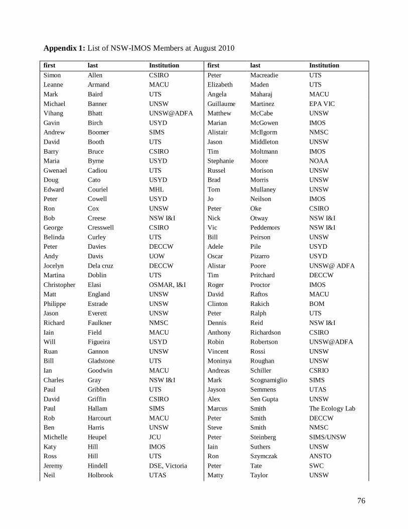
76
Appendix 1: List of NSW-IMOS Members at August 2010
first last Institution first last Institution
Simon Allen CSIRO Peter Macreadie UTS
Leanne Armand MACU Elizabeth Maden UTS
Mark Baird UTS Angela Maharaj MACU
Michael Banner UNSW Guillaume Martinez EPA VIC
Vihang Bhatt UNSW@ADFA Matthew McCabe UNSW
Gavin Birch USYD Marian McGowen IMOS
Andrew Boomer SIMS Alistair McIlgorm NMSC
David Booth UTS Jason Middleton UNSW
Barry Bruce CSIRO Tim Moltmann IMOS
Maria Byrne USYD Stephanie Moore NOAA
Gwenael Cadiou UTS Russel Morison UNSW
Doug Cato USYD Brad Morris UNSW
Edward Couriel MHL Tom Mullaney UNSW
Peter Cowell USYD Jo Neilson IMOS
Ron Cox UNSW Peter Oke CSIRO
Bob Creese NSW I&I Nick Otway NSW I&I
George Cresswell CSIRO Vic Peddemors NSW I&I
Belinda Curley UTS Bill Peirson UNSW
Peter Davies DECCW Adele Pile USYD
Andy Davis UOW Oscar Pizarro USYD
Jocelyn Dela cruz DECCW Alistar Poore UNSW@ ADFA
Martina Doblin UTS Tim Pritchard DECCW
Christopher Elasi OSMAR, I&I Roger Proctor IMOS
Matt England UNSW David Raftos MACU
Philippe Estrade UNSW Clinton Rakich BOM
Jason Everett UNSW Peter Ralph UTS
Richard Faulkner NMSC Dennis Reid NSW I&I
Iain Field MACU Anthony Richardson CSIRO
Will Figueira USYD Robin Robertson UNSW@ADFA
Ruan Gannon UNSW Vincent Rossi UNSW
Bill Gladstone UTS Moninya Roughan UNSW
Ian Goodwin MACU Andreas Schiller CSRIO
Charles Gray NSW I&I Mark Scognamiglio SIMS
Paul Gribben UTS Jayson Semmens UTAS
David Griffin CSIRO Alex Sen Gupta UNSW
Paul Hallam SIMS Marcus Smith The Ecology Lab
Rob Harcourt MACU Peter Smith DECCW
Ben Harris UNSW Steve Smith NMSC
Michelle Heupel JCU Peter Steinberg SIMS/UNSW
Katy Hill IMOS Iain Suthers UNSW
Ross Hill UTS Ron Szymczak ANSTO
Jeremy Hindell DSE, Victoria Peter Tate SWC
Neil Holbrook UTAS Matty Taylor UNSW

77
Clive Holden OFS Peter Thompson CSIRO
Roy Hughes DSTO Ian Turner UNSW
Josh Humphries UNSW Adriana Verges UNSW
Charlie Huveneers SARDI Ana Vila-Concejo USYD
Tim Ingleton DECCW Hua Wang UNSW@ADFA
Michael Jakuba USYD Tim Ward SARDI
Donghui Jiang UNSW@ADFA Scarla Weeks U.Qld
Emma Johnston UNSW Stefan Williams USYD
Alan Jordan DECCW Jane Williamson MACU
Brendan Kelaher DECCW-Marine
Parks
Kate Wilson DECCW
Steve Kennelly NSW I&I Julie Wood UNSW
Andrew Kiss UNSW@ADFA Robert Woodham DoD-RAN
Daijiro (DJ) Kobashi GU Cheng-Lung Wu UNSW
Mark Kulmar MHL Bob You DECCW
Jim Lawler MHL Jock Young CSIRO
Randall Lee EPA VIC Fan Zhang UNSW@ADFA
Helen Macdonald UNSW

78
Appendix 2: List of honours, post-graduate students and post-doctoral fellows using NSW-IMOS data
Name Degree/start Institution Topic
Penny Ajani PhD 2010 MACU Phytoplankton of the East Australian Current
Kate Lee MSc 2010 MACU Assessing habitat protection zones for the blue
groper in Sydney
TBC MSc 2010 MACU Assessing Habitat protection reserves for the
Wobbygong shark
Alex Pursche PhD 2007 UNSW Mulloway migration
Natasha Henschke Hons 2009,
PhD 2010
UNSW Salp ecology
Josh Humphries PhD 2010 UNSW Eddy structure and gliders
Tom Mullaney PhD 2004 UNSW Larval fish and EAC water masses
Ben Harris Hons 2009
PhD 2010
UNSW Krill population ecology
Tegan Sime Hons 2010 UNSW Krill trophic ecology
Jackie Chan PhD 2008 UNSW Eastern king prawn population structure
Ruan Gannon PhD 2010 UNSW Coastal oceanography and fish migrations
Gwen Cadiou PhD 2010-12 UNSW Connectivity between predator populations in
NSW Marine Protected Areas
Helen MacDonald Hons2007
PhD 2009
UNSW ROMS modelling of the NSW continental shelf
Julie Wood PhD 2009 UNSW Analysis of the ORS and IMOS data off Sydney
Dr Vincent Rossi Post-doc 2010-
2012
UNSW/UWA Nutrient cycling in the EAC and LC.
Dr Jason Everett Post-doc 2009-
2011
UNSW Salps and EAC eddies
TBA Post-doc 2010-
2012
UNSW/UTS/I&I Estuarine predators
Donghui Jiang PhD UNSW ADFA On the Upwelling-downwelling Events along the
Coast of Jervis Bay, New South Wales
Fan Zhang PhD UNSW@ADFA Analysing the Socio-economic Benefits of NSW-IMOS
Vihang Bhatt PhD UNSW@ADFA Modeling of South Pacific Subtropical Mode
Water: Seasonal and Inter-Annual Variability
Justine (Retnowaty)
Djajadikarta
Hons/2009 UTS Phytoplankton diversity of the EAC and its
associated eddies
Gabriel Shaw Hons/2010 UTS Nutrient control of primary production in the
Tasman Sea
Dr Christel Hassler Post-doc 2009-
2011
UTS Novel technologies to resolve the role of organic
matter on iron chemistry and bioavailability in the South Pacific Ocean
Dr. Oscar Pizarro Post-doc 2010-
2014
USYD Cost-effective autonomous systems for large
scale monitoring of marine protected areas
Dr. Michael Jakuba Post-doc 2008-
2011
USYD Efficient and adaptive AUV survey
Stephen Barkby PhD/2007 USYD Bathymetric Simultaneous Localisation and
Mapping
Ariell Friedman PhD/2009 USYD Rugosity, Slope and Aspect from Bathymetric
Stereo Image Reconstructions
Asher Bender PhD/2009 USYD Adaptive Exploration Of Benthic Habitats Using
Gaussian Processes
Lashika Medagoda PhD 2008-
Mar.2012
USYD Water Column Current Profile Aided
Localisation for Autonomous Underwater
Vehicles
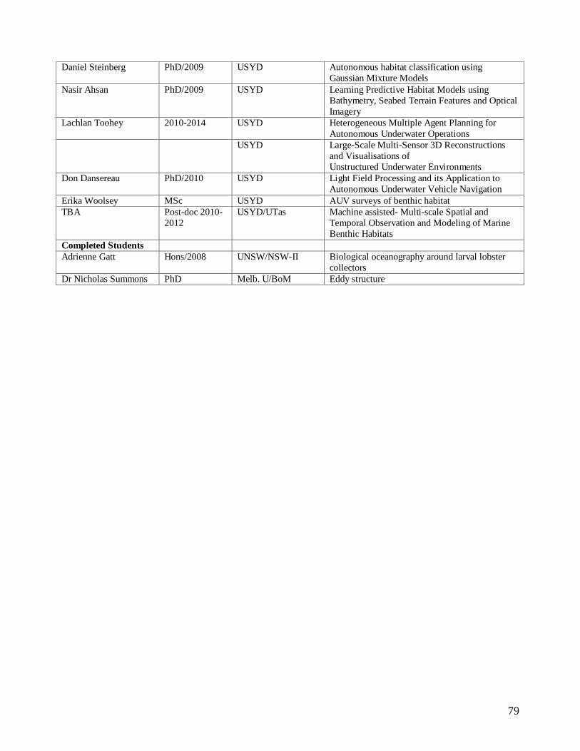
79
Daniel Steinberg PhD/2009 USYD Autonomous habitat classification using
Gaussian Mixture Models
Nasir Ahsan PhD/2009 USYD Learning Predictive Habitat Models using
Bathymetry, Seabed Terrain Features and Optical
Imagery
Lachlan Toohey 2010-2014 USYD Heterogeneous Multiple Agent Planning for
Autonomous Underwater Operations
USYD Large-Scale Multi-Sensor 3D Reconstructions
and Visualisations of
Unstructured Underwater Environments
Don Dansereau PhD/2010 USYD Light Field Processing and its Application to
Autonomous Underwater Vehicle Navigation
Erika Woolsey MSc USYD AUV surveys of benthic habitat
TBA Post-doc 2010-
2012
USYD/UTas Machine assisted- Multi-scale Spatial and
Temporal Observation and Modeling of Marine
Benthic Habitats
Completed Students
Adrienne Gatt Hons/2008 UNSW/NSW-II Biological oceanography around larval lobster
collectors
Dr Nicholas Summons PhD Melb. U/BoM Eddy structure

80
Appendix 3. Research needs for NSW-IMOS, and what was not funded under EIF-IMOS (Dec 09
announcement)
1. Installation of 4 HF Radar stations between Laurieton/Taree (~31º 40‟S) and Sydney
(~34ºS) focusing on EAC separation dynamics;
2. The deployment of an additional oceanographic mooring pair in Stockton Bight to elucidate
the nature of the biological response to persistent EAC driven upwelling and give cal/val to
the HF Radar.
3. Supplement ocean gliders with cross-shelf transects and including the EAC and eddy field
by an AUV-REMUS
4. Additional bio-optical sensors for the NSW shelf moorings
5. Seals as CTD Samplers for the NSW south coast.
HF radar deployments to study the EAC separation zone:
We are requesting the deployment of an HF radar system in the Stockton Bight region to cover the
important EAC separation zone. The primary requirement is to measure surface currents over a
large alongshore distance. The most cost effective way to do this is to use the SeaSonde genre for 3
stations, to take advantage of the 180‐degree window of azimuth. The trade‐off is that wave height
observations will be limited, but if the southern‐most of the 4 stations is a WERA phased array then
good quality significant wave height data will be available and will book‐end the southern end to
match the Coffs Harbour wave‐capable system already installed. We desire a range of ~150 km
with an expectation that it will be up to 200 km during the daytime. The separation of stations in the
layout is consistent with this range specification.
The SeaSonde radar stations at Laurieton, Seal Rocks and Redhead have been placed to optimise
the coverage for long range systems (Fig. 5; Table 8). The WERA system at Long Reef at the
southern end brings current observations down almost to the Sydney Heads and provides wave
height data.
Table 8. Details of the proposed HF Radar station locations.
Radar Station Latitude Longitude
Laurieton SeaSonde 31°38‟49.59‟‟S 152°50‟24.08‟‟E
Seal Rocks SeaSonde 32°26‟28.47‟‟S 152 °32‟ 20.33‟‟E
Redhead SeaSonde 33°00‟48.01‟‟S 151°43‟31.16‟‟E
Long Reef WERA 33°44'32.82"S 151°19'11.33"E

81
Cross-shelf transects by a REMUS?
In addition to the current AUV we propose an enhancement of the facility by the purchase of a
REMUS „submarine‟ which will provide the ability to undertake high resolution oceanographic
surveys under high flow regimes. We propose a series of high resolution cross shelf transects to be
visited on a regular basis. The proposed sites coincide with existing IMOS infrastructure associated
with other Facilities and the observations that we will obtain complement the extant data sets (e.g
ANMN transects). Sites in SE Queensland, NSW, Tasmania and WA have been identified as
candidate locations for these surveys and each site is in close proximity to one of the ANMN
National Reference Station site. These sites will also feature observations provided by coastal radar
and, where possible, glider deployments (although as stated previously the advantage of this
technology is that the REMUS can occupy transects in high flow environments which is not
possible for the glider). During deployment, the AUV will traverse the continental shelf either at a
fixed depth or on a yo-yo trajectory, collecting a full suite of oceanographic measurements.
The observations obtained include high resolution velocity profiles throughout the water column
(similar to a shipboard ADCP) however the vehicle is equipped with up and down looking ADCPs
so the entire water column will be sampled. This has the advantage of giving the spatial coverage
that is missed by single point moorings. Concurrently the vehicle measures temperature salinity
and different optical properties again, obtaining high resolution data across the shelf where
gradients are typically high. For example to be able to resolve the gradient across a tight thermal
front is a huge step forward in our ability to understand cross shelf processes. Then to be able to
monitor the evolution and persistence of such features over time scales ranging from days to years
is new and exciting.
We propose to visit each of these sites twice a year for a period of two to three weeks at each site.
Cross shelf transects will be run up to three times a week during the deployment period to give a
high resolution view of temporal and spatial variability of currents running along the shelf with
intervals of six months between visits. In addition to this we propose regular monthly transects off
Sydney (when the vehicle is not deployed elsewhere) to give a comprehensive view of the EAC and
its eddy field on the shelf of NSW (Fig. 4). Additional transects could also be conducted off Coffs
Harbour in conjunction with the 2 monthly mooring servicing trips.
Given the turnkey nature of the AUV systems we are proposing to acquire, we envisage training
local operators in each of the nodes to assist with, and eventually take over, these survey activities.
Eventually it is envisaged that the deployments along the NSW transects could be conducted in
conjunction with the monthly hydrographic sampling run. It may be possible to deploy the vehicle
over the side of the boat at the start of the sampling and retrieve it at the end, thereby providing
crucial spatial context to the discreet water samples obtained at the NRS sites.
Present IMOS facilities devoted to measuring physical oceanographic variables either provide a
sustained and rich set of co-registered measurements in a fixed location (moorings) or a more
limited set of observations over deployments that traverse hundreds to thousands of km (gliders and
floats). The IMOS nodes are interested in extending current observational capabilities such that a
rich set of water column measurements similar to those collected point-wise at mooring sites can be
regularly recovered with precisely repeatable transects on the order of 100 km in length.
82
AUV systems designed for water-column sampling are mature and in regular use throughout the
world Recent studies off Cape Cod, MAS, USA have conducted repeat small AUV (REMUS)
surveys as part of a four-year program of repeat surveys to collect coastal current data associated
with a mooring array. By providing repeatable, synoptic measurements of a slice of the shelf
currents fast, propeller driven AUVs equipped with ADCPs, a CTD and fluorometers complement
the spatial under-sampling inherent to fixed moorings. In contrast, moorings provide a persistent
set of measurements that avoids the temporal under-sampling inherent to assets with limited
endurance. Together these Eulerian measurements complement the Lagrangian and quasi-
Lagrangian measurements generated by floats and gliders, respectively.
The IMOS AUV Facility is proposing an enhancement through the acquisition of AUV systems
capable of operating in energetic boundary currents. Fast AUVs moving at 1 m/s to 2 m/s (86
km/day to 172 km/day) to complement existing facilities by collecting three-dimensional nearly
synoptic offshore transects unobtainable with other IMOS assets in the energetic portions of the
East Australia and Leeuwin currents where water velocities substantially exceed the 25 cm/s
maximum speed of IMOS facility gliders. A rich set of water column measurements similar to
those collected point wise at mooring sites can thereby be regularly recovered with precisely
repeatable transects.
We propose a series of repeat AUV REMUS lines co-incident with the Coffs Harbour and Sydney
mooring arrays to provide the spatial context for the point wise measurements obtained at the
mooring arrays. The proposed sites coincide with existing IMOS infrastructure associated with
other Facilities and the observations that we will obtain complement the extant data sets (e.g
ANMN transects. These sites will also feature observations provided by coastal radar and, where
possible, glider deployments (although as stated previously the advantage of this technology is that
a propeller driven AUV can occupy transects in high flow environments which is not possible for
the glider). During deployment, the AUV will traverse the continental shelf either at a fixed depth
or on a yo-yo trajectory depending on total water depth, collecting a full suite of oceanographic
measurements.
The observations obtained will include high-resolution velocity profiles throughout the water
column (similar to a shipboard ADCP) however the vehicle is equipped with up and down looking
ADCPs so the entire water column will be sampled. This has the advantage of giving the spatial
coverage that is missed by single point moorings. Concurrently the vehicle measures temperature,
salinity and different optical properties thereby obtaining high-resolution data across the shelf
where gradients are typically high. For example to be able to resolve the gradient across a tight
thermal front is a huge step forward in our ability to understand cross shelf processes. The ability to
monitor the evolution and persistence of such features over time scales ranging from days to years
is new and exciting.

83
Appendix 4.
Guidelines for Prioritisation of Infrastructure Needs
Dr Katy Hill, IMOS Scientific Officer. 19th March 2010.
Nodes are expected to recommend an overall priority based on an assessment of scientific priority, technical maturity and capability/capacity.
Overall Priority.
• Essential – Should be funded. • High priority – Could be funded subject to co‐investment. • Next Stage – Essential or High scientific priority, but either the technology is not yet mature, or the facility does not have the capability/capacity to expand at this stage. Scientific Priority
• Essential – this data‐stream is essential for the node to meet its core science objectives. • High priority – this data‐stream would be very useful in addressing some of the science questions. • Lower priority – this data‐stream would have some use in addressing one or more of the node science questions. Technical Maturity
• Very mature – this platform/sensor/technique has an established role in the sustained observing system. • Mature – this platform/sensor/technique has been deployed as part of short term experiments and it utility/robustness confirmed. • Maturing – this platform/sensor/technique is new and has not been tested as part of a short term experiment, or initial tests suggest that it is not yet robust. Capability/ Capacity
• Capability and Capacity ‐ This facility/agency has an established track record for deploying this platform and delivering data. The leader has confirmed that there is capacity for the facility to expand /deliver data‐streams. • Capacity limited ‐ This facility/agency has a successful track record for deploying this platform and delivering data, but has limited capacity to expand (i.e. man‐power). • Capability limited ‐ This facility/agency has experienced setbacks in delivering data or has an unproven track record. Template
Proposed infrastructure name, and its priorities
Scientific priority Technical maturity: Capability/Capacity Overall priority:
E, Hi or Lower Hi, Mature, M‟ing Both or Limited E, HP, or Next stage

84
Appendix 5. Deep Sea Research Part II Special Issue - “ The East Australian Current – its eddies
and impacts ” Guest Editors Suthers, Baird, Roughan, Young, Ridgway
List of contents:
(many of these papers are now available at the DSR-II website)
1) The strengthening East Australian Current, its eddies and biological effects – an introduction
and overview to the special issue.
Suthers, Young, Baird, Roughan, Everett, Brassington, Byrne, Condie, Hartog, Hassler,
Hobday, Holbrook, Malcolm, Oke, Thompson, and Ridgway
2) ENSO to multi-decadal time scale changes in East Australian Current transports and Fort
Denison sea level: oceanic Rossby waves as the connecting mechanism
Neil J Holbrook, Ian D Goodwin, Shayne McGregor, Ernesto Molina, Scott B Power
3) Variation in sea temperature and the East Australian Current in the Solitary Islands region
between 2001-2008
Hamish A. Malcolm, Peter L. Davies, Alan Jordan, Stephen D. A. Smith
4) Observed and simulated Lagrangian and eddy characteristics of the East Australian Current
and Tasman Sea
Gary B. Brassington, Nicholas Summons and Rick Lumpkin
5) The cold-core eddy and strong upwelling off the coast of New South Wales in early 2007
Peter R. Oke and David A. Griffin
6) The effect of surface flooding on the physical-biogeochemical dynamics of a warm core eddy
off southeast Australia.
Mark E. Baird, Iain M. Suthers, David A. Griffin, Ben Hollings, Charitha Pattiaratchi,
Jason D. Everett, Moninya Roughan, Kadija Oubelkheir, Martina Doblin
7) Contrasting local retention and cross-shore transports of the East Australian Current and the
Leeuwin Current and their relative influences on the life histories of small pelagic fishes.
S. A. Condie, J. V. Mansbridge and M. L. Cahill
8) Modelling seasonal and interannual variability in a Western Boundary Current and its impact
on coastal connectivity.
Moninya Roughan, Helen S. Macdonald Mark E. Baird, Tim M. Glasby
9) Contrasting oceanographic conditions and phytoplankton communities on the east and west
coasts of Australia.
Thompson, P.A. Bonham, P. Waite A.M. Clementson, L.A. Cherukuru, N. Doblin, M.A.
10) Characterisation of water masses and phytoplankton nutrient limitation in the East Australian
Current separation zone during spring 2008
Hassler CS, Djajadikarta JR, Doblin MA, Everett JD, Thompson PA
85
11) Characteristic ichthyoplankton taxa in the separation zone of the East Australian Current:
larval assemblages as tracers of coastal mixing
Augy Syahailatua, Moninya Roughan and Iain M. Suthers
12) Growth variability and stable isotope composition of two larval carangid fishes in the East
Australian Current: The role of upwelling in the separation zone
Augy Syahailatua, Matthew D. Taylor and Iain M. Suthers
13) Analysis of southeast Australian zooplankton observations of 1938-42 using synoptic
oceanographic conditions.
Mark E. Baird, Jason D. Everett, Iain M. Suthers
14) Sea urchin development in a global change hotspot, potential for southerly migration of
thermotolerant propagules
M. Byrne, P. Selvakumaraswamy, M.A. Ho, E. Woolsey and H.D. Nguyen
15) The biological oceanography of the East Australian Current and surrounding waters in
relation to tuna and billfish catches off eastern Australia
J.W. Young, A.J. Hobday, R.J. Kloser, P.I. Bonham, L.A. Clementson, R.A. Campbell and
M.J. Lansdell
16) Defining dynamic pelagic habitats in oceanic waters off eastern Australia
J. Hobday, J. W. Young, C. Moeseneder, J. M. Dambacher
17) Habitat overlap between southern bluefin tuna and yellowfin tuna in the east coast longline
fishery – implications for present and future spatial management
Jason R. Hartog, Alistair J. Hobday, Richard Matear, Ming Feng
END OF NSW-IMOS Aug10-DOCUMENT