Floodplain Risk Management Study - cityofsydney.nsw.gov.au
57
Floodplain Risk Management Study Alexandra Canal Floodplain Risk Management Study and Plan W4948 W4948 Prepared for City of Sydney 20 May 2014 Floodplain Risk Management Study Alexandra Canal Floodplain Risk Management Study and Plan W4948
Transcript of Floodplain Risk Management Study - cityofsydney.nsw.gov.au

Floodplain Risk Management Study
Alexandra Canal Floodplain Risk Management Study and Plan W4948
W4948
Prepared for City of Sydney
20 May 2014
Floodplain Risk Management Study
Alexandra Canal Floodplain Risk Management Study and Plan W4948

Floodplain Risk Management Study City of Sydney Alexandra Canal Floodplain Risk Management Study and Plan
20 May 2014 Cardno Page ii W:\_Current Projects\4948 AlexandraCanal FRMSP\Report\R001-W4948-Alex Canal FPRMSv6.docx
Document Information
Prepared for City of Sydney
Project Name Alexandra Canal Floodplain Risk Management Study and Plan
File Reference R001-W4948-Alex Canal FPRMSv6.docx
Job Reference W4948
Date 20 May 2014
Contact Information
Cardno (NSW/ACT) Pty Ltd
ABN 95 001 145 035
Level 9, The Forum, 203 Pacific Highway
St Leonards NSW 2065
PO Box 19 St Leonards NSW
Telephone: 02 9496 7700
Facsimile: 02 9439 5170
International: +61 2 9496 7700
www.cardno.com
Document Control
Version Date Author Reviewer
Preliminary Draft 4th June 2013 Andrew Reid, Emma Maratea,
Bala Kilaparty, Tina Fang
Rhys Thomson
Draft 25 June 2013 Andrew Reid, Emma Maratea,
Bala Kilaparty, Tina Fang
Rhys Thomson
Revised Draft 6 August 2013 Andrew Reid Rhys Thomson
Draft for Exhibition 12 September 2013 Andrew Reid Rhys Thomson
Final Draft 11 February 2014 Andrew Reid Rhys Thomson
Final 20 May 2014 Andrew Reid Rhys Thomson
This report was adopted by the City of Sydney Council on 17 March 2014.
© Cardno 2014. Copyright in the whole and every part of this document belongs to Cardno and may not be used, sold, transferred, copied or reproduced in whole or in part in any manner or form or in or on any media to any person other than by agreement with Cardno.
This document is produced by Cardno solely for the benefit and use by the client in accordance with the terms of the engagement. Cardno does not and shall not assume any responsibility or liability whatsoever to any third party arising out of any use or reliance by any third party on the content of this document.

Floodplain Risk Management Study City of Sydney Alexandra Canal Floodplain Risk Management Study and Plan
20 May 2014 Cardno Page iii W:\_Current Projects\4948 AlexandraCanal FRMSP\Report\R001-W4948-Alex Canal FPRMSv6.docx
Foreword
The NSW Government Flood Prone Land Policy is directed towards providing solutions to existing
flood problems in developed areas and ensuring that new development is compatible with the flood
hazard and does not create additional flooding problems in other areas.
Under the policy, the management of flood prone land is the responsibility of Local Government.
The State Government subsidises flood management measures to alleviate existing flooding
problems and provides specialist technical advice to assist Councils in the discharge of their
floodplain management responsibilities. The Commonwealth Government also assists with the
subsidy of floodplain modification measures.
The Policy identifies the following floodplain management ‘process’ for the identification and
management of flood risks:
1. Formation of a Committee -
Established by a Local Government Body (Local Council) and includes community group
representatives and State agency specialists.
2. Data Collection -
The collection of data such as historical flood levels, rainfall records, land use, soil types etc.
3. Flood Study -
Determines the nature and extent of the flood problem.
4. Floodplain Risk Management Study –
Evaluates floodplain management measures for the floodplain in respect of both existing and
proposed development.
5. Floodplain Risk Management Plan –
Involves formal adoption by Council of a management plan for the floodplain.
6. Implementation of the Plan –
Implementation of actions to manage flood risks for existing and new development.
This Alexandra Canal Catchment Floodplain Risk Management Study is developed from the
previous Flood Study, prepared by Cardno for the City of Sydney Council.

Floodplain Risk Management Study City of Sydney Alexandra Canal Floodplain Risk Management Study and Plan
20 May 2014 Cardno Page iv W:\_Current Projects\4948 AlexandraCanal FRMSP\Report\R001-W4948-Alex Canal FPRMSv6.docx
Executive Summary
Cardno were commissioned by the City of Sydney to undertake a Floodplain Risk Management
Study and Plan (FRMSP) for the Alexandra Canal Catchment. This FRMSP has been undertaken
to define the existing flooding behaviour and associated hazards, and to investigate possible
management options to reduce flood damage and risk. The tasks were undertaken alongside
community consultation to ensure that community concerns were addressed.
The overall objective of this study is to develop a FRMSP that addresses the existing, future and
continuing flood problems, taking into account the potential impacts of climate change, in
accordance with the NSW Government’s Flood Policy, as detailed in the Floodplain Development
Manual (NSW Government, 2005).
The total catchment area is approximately 1,141ha and includes the suburbs of Alexandria,
Rosebery, Erskineville, Beaconsfield, Zetland, Waterloo, Redfern, Newtown, Eveleigh, Surry Hills
and Moore Park. It is generally bounded by the Eastern Distributor and Moore Park in the east,
Gardeners Road in the south, Sydney Park and Newton in the west and Albion Street in the north-
east. The majority of the trunk drainage system is owned by Sydney Water Corporation, whilst the
feeding drainage systems are primarily owned by Council.
The majority of the catchment is fully developed and consists predominantly of medium to high-
density housing, commercial and industrial development with some large open spaces.
A draft flood study has been prepared by Cardno (2013) to define the flood behaviour in the study
area, including both mainstream and overland flooding. The Flood Study determined the flood
behaviour for the 100 year ARI, 20 year, 10 year, 5 year, 2 year and 1 year Average Recurrence
Interval (ARI) events together with the Probable Maximum Flood (PMF). The primary flood
characteristics reported for the design events include depths, levels and velocities. The study has
also defined the Provisional Flood Hazard for flood-affected areas. An assessment of the impact of
blockages of culverts and pits was also undertaken for the flood study.
The community consultation undertaken as part of the FRMS built on the consultation undertaken
as part of the Flood Study (Cardno, 2013). The purpose of the Flood Study (Cardno, 2013)
consultation was to inform the community about the study and gain an understanding of the
community’s experience with historical flooding in the catchment. The purpose of the more recent
consultation undertaken as part of this FRMS was to inform the community about the study,
identify community concerns and attitudes, to gather information from the community on potential
options for the floodplain and to develop and maintain community confidence in the study results.
The community consultation consisted of:
A community brochure and survey;
A press release; and
Community information meeting during the public exhibition period.
Provisional flood hazard was defined as part of the Flood Study (Cardno, 2013) based on velocity
and depth of flood waters for the PMF, 100 and 5 Year ARI events. The additional hazard factors
outlined in the Floodplain Development Manual were considered as part of a true hazard
assessment undertaken in this FRMS.
Flooding is likely to cause significant social and economic damages to the community. A flood
damage assessment for the existing catchment and floodplain conditions has been undertaken as
part of the current study. The assessment is based on damage curves that relate the depth of
flooding on a property to the potential damage within the property. Average Annual Damage (AAD)
is calculated on a probability approach using the flood damages calculated for each design event.
Floodplain Risk Management Study City of Sydney Alexandra Canal Floodplain Risk Management Study and Plan
20 May 2014 Cardno Page v W:\_Current Projects\4948 AlexandraCanal FRMSP\Report\R001-W4948-Alex Canal FPRMSv6.docx
The average annual damage estimated for the Alexandra Canal floodplain under existing
conditions is approximately $13.0 million (excluding GST).
The majority of flooding within the Alexandra Canal catchment is characterised by overland flow.
The critical duration is between 1 and 3 hours across the catchment, with the peak of the flood
reached approximately 30 minutes to 1 hour after the start of the storm. This is considered short
duration “flash” flooding. The short time period until flooding occurs does not allow sufficient time to
evacuate residents from their properties. A review of the current emergency response
arrangements has been undertaken considering the nature of flooding within the catchment.
Floodplain management is primarily employed through development controls and other planning
measures. A review of the relevant state and local planning instruments has been undertaken with
regards to floodplain management within Alexandra Canal Catchment. The outcomes of this review
have been incorporated into the proposed floodplain risk management options.
A key component of development controls relating to floodplain management is the adoption of a
flood planning level. The Sydney LEP 2012 currently defines the flood planning level as the
100 year ARI event plus a freeboard of 0.5m. The suitability of this level for planning purposes in
the Alexandra Canal Catchment has been review based on flood behaviour and land use types.
Measures available for the management of flood risk can be categorised according to the way in
which the risk is managed. Various options for flood risk management have been identified and
assessed. These options can be broadly defined into three categories:
Flood modification measures – Flood modification measures are aimed at preventing /
avoiding or reducing the likelihood of flood risks. These options reduce the risk by
modifying the flood behaviour in the catchment.
Property modification measures – Property modification measures are focused on
preventing / avoiding and reducing consequences of flood risks. Rather than necessarily
modify the flood behaviour, these options aim to modify properties (both existing and future)
so that there is a reduction in flood risk.
Emergency response modification measures – Emergency response modification
measures aim to reduce the consequences of flood risks. These measures generally aim
to modify the behaviour of people during a flood event.
It is possible to quantitatively assess the economic benefits of some of the options, namely those
that were hydraulically modelled, and those with known benefits. For those options, a benefit-cost
ratio can be calculated. Where a desktop assessment was utilised for options (as opposed to
hydraulic modelling), a detailed economic analysis was not undertaken. In these cases a
judgement on the likely economic benefits of the options was made.
A multi-criteria matrix assessment approach has been adopted for the comparative assessment of
all options identified using a similar approach to that recommended in the Floodplain Development
Manual (2005). This approach uses a subjective scoring system to assess the merits of various
options against economic, social and environmental criteria. The principal merits of such a system
are that it allows comparisons to be made between alternatives using a common index. In addition,
it makes the assessment of alternatives “transparent” (i.e. all important factors are included in the
analysis). However, this approach does not provide an absolute “right” answer as to what should
be included in the plan and what should be omitted. Rather, it provides a method by which
stakeholders can re-examine options and, if necessary, debate the relative scoring assigned. Each
option is given a score according to how well the option meets specific considerations.
Floodplain Risk Management Study City of Sydney Alexandra Canal Floodplain Risk Management Study and Plan
20 May 2014 Cardno Page vi W:\_Current Projects\4948 AlexandraCanal FRMSP\Report\R001-W4948-Alex Canal FPRMSv6.docx
The outcome of the multi-criteria matrix assessment is a ranked list of potential floodplain risk
management options for implementation in the floodplain. The following measures were highly
ranked and should be considered for further assessment and / or implementation:
Non-Structural Measures-
FM15 Liveable Green Network
FM23 Increased pit cleaning and maintenance
EM1 Information Transfer to SES
EM2 Preparation of District DISPLAN
EM3 Preparation of Local Flood Plan
PM3 Opportunities related to Large Scale Future Development
PM2 Development Controls and Policies
EM5 Public awareness and education
PM1 LEP Update
EM6 Flood warning signs at critical locations
PM9 Flood Proofing Guidelines
EM4 Flood Warning System and Temporary Refuge
Structural Measures-
FM9 Link Road to Alexandra Canal Upgrade – Maddox Street Alignment
FM6 Additional pipes from Macdonald Street and Coulson Street to Alexandra Canal
(alternatively FM21 Detention Basin in Sydney Park – Offset Storage from Macdonald
Street)
FM7 Detention basins in Redfern Park.
FM18 Additional Drainage Network at Harcourt Parade to Gardeners Road
FM17 Detention basin in Turruwul Park
FM20 Sheas Creek Channel Flood Walls
The implementation strategy for recommended floodplain risk management measures is outlined in
the Floodplain Risk Management Plan.
The Draft Flood Study, Draft Floodplain Risk Management Study and Draft Floodplain Risk
Management Plan were placed on public exhibition for a period of four weeks from 28 October
2013 to 25 November 2013 to allow input from the community and interested parties to the Study
and its outcomes. Exhibition documents were available for review at several community locations
and on Council’s website.
Details of the exhibition were included in newspapers, mailed/emailed to previous contributors of
flood surveys, and emailed to community groups. A community drop-in session was held on
Wednesday 20 November 2013 at the Alexandria Town Hall, 73 Garden Street, Alexandria.
Officers from Council, Office of Environment and Heritage and Cardno were present and available
to answer community questions.

Floodplain Risk Management Study City of Sydney Alexandra Canal Floodplain Risk Management Study and Plan
20 May 2014 Cardno Page vii W:\_Current Projects\4948 AlexandraCanal FRMSP\Report\R001-W4948-Alex Canal FPRMSv6.docx
One telephone enquiry was received, three people attended the drop-in session, and one written
submission was received. All these were responded to by Council and no further action is required
for the Alexandra Canal Floodplain Risk Management Study and Plan.
Floodplain Risk Management Study City of Sydney Alexandra Canal Floodplain Risk Management Study and Plan
20 May 2014 Cardno Page viii
Table of Contents
Foreword iii
Executive Summary iv
Glossary xiii
Abbreviations xviii
1 Introduction 1
1.1 Study Context 1
1.2 Study Objectives 2
2 Catchment Description 6
3 Available Data 8
3.1 Previous Studies and Reports 8
3.1.1 Alexandra Canal Catchment Flood Study 8
3.1.2 Green Square – West Kensington Floodplain Risk Management Study & Plan 8
3.1.3 Additional Studies 9
3.2 Survey Information 9
3.2.1 Floor Level Survey 9
3.3 GIS Data 9
3.4 Site Inspections 10
4 Consultation 11
4.1 Community Consultation 11
4.1.1 Community Brochure and Survey 11
4.2 Floodplain Committee and Stakeholder Consultation 17
4.3 Public Exhibition 17
5 Existing Flood Behaviour 19
5.1 Flood Study 19
5.2 Flooding Behaviour 23
5.2.1 Munni Street Sub-Catchment 23
5.2.2 Sheas Creek Sub-Catchment 23
5.2.3 Rosebery Sub-Catchment 23
5.2.4 Alexandra Canal Sub-Catchment 24
5.3 Historical Flooding 24
5.4 Flood Hazard 25
5.4.1 Provisional Flood Hazard 25
5.4.2 True Flood Hazard 29
5.5 Hydraulic Categorisation 36
6 Current Economic Impact of Flooding 40
6.1 Background 40
6.2 Floor Level and Property Survey 40
6.3 Damage Analysis 41
6.3.1 Residential Damage Curves 41
6.3.2 Average Weekly Earnings 42
6.3.3 Commercial Damage Curves 42
6.3.4 Industrial Damage Curves 43

Floodplain Risk Management Study City of Sydney Alexandra Canal Floodplain Risk Management Study and Plan
20 May 2014 Cardno Page ix
6.4 Adopted Damage Curves 44
6.5 Average Annual Damage 44
6.6 Results 45
6.7 Discussion 46
7 Environmental and Social Characteristics 48
8 Flood Emergency Response Arrangements 50
8.1 Flood Emergency Response 50
8.2 Flood Emergency Responses Documentation 50
8.2.1 DISPLAN 50
8.2.2 Local Flood Plan 51
8.3 Emergency Service Operators 52
8.4 Flood Warning Systems 52
8.5 Access and Movement During Flood Events 53
8.5.1 Access Road Flooding 53
8.5.2 Evacuation Centres 57
8.6 Flood Emergency Response Planning Classifications 59
9 Policies and Planning 62
9.1 Planning Instruments / Policy 62
9.2 Sydney Local Environmental Plan 2012 62
9.2.1 Flood Controls 62
9.2.2 Current Land Use and Zoning 64
9.3 Development Control Plans 70
9.4 Relevant Policies and Plans 70
9.4.1 Floodplain Management Policy 70
9.4.2 Decentralised Water Master Plan 2012 - 2030 71
9.5 Planning Recommendations for Alexandra Canal Floodplain 71
10 Flood Planning Level Review 73
10.1 Background 73
10.2 Likelihood of Flooding 73
10.3 Current FPL 74
10.4 Land Use and Planning 74
10.5 Damage Cost Differential Between Events 74
10.6 Incremental Height Difference Between Events 75
10.7 Consequence of Adopting the PMF as a Flood Planning Level 75
10.8 Environmental and Social Issues 76
10.9 Climate Change 76
10.10 Risk 76
10.11 Culvert Blockage 77
10.12 Freeboard Selection 77
10.13 Flood Planning Level Recommendations 78
10.14 Flood Planning Maps 80
11 Floodplain Risk Management Options 81
11.1 Managing Flood Risk 81
11.2 Existing Case 81
11.3 Flood Modification Measures 82
11.3.1 Short to Medium Term Flood Modification Measures 82
11.3.2 Long Term Flood Modification Measures 91
11.3.3 Environmental Considerations 96

Floodplain Risk Management Study City of Sydney Alexandra Canal Floodplain Risk Management Study and Plan
20 May 2014 Cardno Page x
11.4 Property Modification Measures 97
11.4.1 PM1 – LEP and DCP Update 97
11.4.2 PM2 – Floodplain Management Policy 98
11.4.3 PM3 – Opportunities Related to Large Scale Future Development 99
11.4.4 PM4 – House Raising 99
11.4.5 PM5 – House Rebuilding 101
11.4.6 PM6 – Voluntary Purchase 101
11.4.7 PM7 – Land Swap 102
11.4.8 PM8 – Council Redevelopment 102
11.4.9 PM9 – Prepare Flood Proofing Guidelines 102
11.5 Emergency Response Modification Measures 103
11.5.1 EM 1 – Information Transfer to SES 103
11.5.2 EM 2 – Prepare a District DISPLAN 103
11.5.3 EM 3 – Prepare a Local Flood Plan 104
11.5.4 EM 4 – Flood Warning System and Short-Term Refuges 105
11.5.5 EM 5 – Public Awareness and Education 105
11.5.6 EM 6 – Flood Warning Signs at Critical Locations 106
11.6 Data Collection Strategies 106
11.7 Green Square – West Kensington 106
11.8 Additional Inflows to Alexandra Canal 107
12 Economic Assessment of Options 108
12.1 Preliminary Costing of Options 108
12.1.2 Long Term Measure (FM11) 108
12.2 Average Annual Damage Assessment of Measures 110
12.3 Benefit Cost Ratio of Measures 110
12.3.2 Economic Assessment of Desktop Assessed Measures 111
13 Multi-Criteria Matrix Assessment 112
13.1 Scoring System 112
14 Conclusions 117
15 References 119
Appendices
Appendix A Community Brochure, Survey and Photographs
Appendix B Committee and Stakeholder Workshop Outcomes
Appendix C Environmental and Social Assessment
Appendix D Flood Management Measure Modelling Results
Appendix E Measure Costing
Appendix F Green Square Superseded Options Review
Appendix G Multi-Criteria Assessment

Floodplain Risk Management Study City of Sydney Alexandra Canal Floodplain Risk Management Study and Plan
20 May 2014 Cardno Page xi
Tables
Table 1-1 Flood Affected Areas 4
Table 4-1 Property Ownership 11
Table 4-2 Property Description 12
Table 4-3 Summary of Age Groups 13
Table 4-4 Flood Affectation of Respondents 14
Table 4-5 Flood Management Approach Rating Summary 16
Table 5-1 Approximate ARI of Historical Rainfall Events (Observatory Hill – 66062) 24
Table 6-1 Flood Damages Categories 40
Table 6-2 CPI Statistics for Residential Damage Curves 42
Table 6-3 CPI Statistics for Commercial Property Damage Estimation 43
Table 6-4 CPI Statistics for Industrial Property Damage Estimation 43
Table 6-5 Flood Damage Assessment Summary 46
Table 8-1 Access Road Flooding 54
Table 8-2 Possible Evacuation Centres 57
Table 8-3 Emergency Response Requirements (as recommended in DECC, 2007) 61
Table 9-1 State Planning Controls 62
Table 9-2 Alexandra Canal Catchment Land Uses 65
Table 10-1 Probability of Experiencing a Given Size Flood or Higher in an Average Lifetime (70 Years) 74
Table 10-2 Damage Differential Costs 75
Table 10-3 Relative Differences Between Design Flood Levels 75
Table 10-4 Climate Change Impacts 76
Table 10-5 Recommended FPLs for Alexandra Canal Catchment 79
Table 11-1 Flood Risk Management Alternatives (SCARM, 2000) 81
Table 11-2 Flood Mitigation Measures 83
Table 11-3 Alternatives in the Long Term Drainage Strategy 94
Table 11-4 Estimates of AAD and NPV for Over-Floor Flooding Scenarios 101
Table 11-5 Reduction in AAD Resulting from House Raising Scenarios 101
Table 11-6 Green Square West Kensington High Priority Measures 107
Table 12-1 Costs of Quantitatively Assessed Measures 108
Table 12-2 Average Annual Damage for Quantitatively Assessment Measures 110
Table 12-3 Summary of Economic Assessment of Management Measure 111
Table 13-1 Criteria for Matrix Assessment 113
Table 13-2 Criteria Scoring System 114

Floodplain Risk Management Study City of Sydney Alexandra Canal Floodplain Risk Management Study and Plan
20 May 2014 Cardno Page xii
Figures
Figure 2-1 Study Area 7
Figure 4-1 Years of Residence 12
Figure 4-2 Age Groups 13
Figure 4-3 Average Rating for Flood Management Approaches 15
Figure 5-1 100 Year ARI Peak Flood Depths 20
Figure 5-2 PMF Peak Flood Depths 21
Figure 5-3 Sub-Catchments 22
Figure 5-4 PMF Provisional Flood Hazard 26
Figure 5-5 100 Year ARI Provisional Flood Hazard 27
Figure 5-6 5 Year ARI Provisional Flood Hazard 28
Figure 5-7 100 Year ARI Critical Duration 31
Figure 5-8 PMF True Hazard 33
Figure 5-9 100 Year ARI True Hazard 34
Figure 5-10 5 Year ARI True Hazard 35
Figure 5-11 Hydraulic Categories – PMF 37
Figure 5-12 Hydraulic Categories – 100 Year ARI 38
Figure 5-13 Hydraulic Categories – 5 Year ARI 39
Figure 6-1 Damage Curves Developed for Alexandra Canal Catchment 44
Figure 6-2 Average Annual Damage Curve for Alexandra Canal Catchment 45
Figure 8-1 Access Road Flooding 56
Figure 8-2 Locations of Possible Evacuation Centres 58
Figure 8-3 Emergency Response Classification Map 60
Figure 9-1 LEP Zones 64
Figure 11-1 Study Area Subcatchments 84
Figure 11-2 Short Term Measures – FM1 to FM10 85
Figure 11-3 Flood Modification Measures (Excluding Long Term Drainage Strategy) 86
Figure 11-4 Measure FM11 Layout 92
Figure 11-5 Sub-Areas for Measure FM11 95
Figure 11-6 Large Scale Re-Development Areas 100
Figure 12-1 Measure FM11 Preliminary Cost Estimates per Sub-Area 109
Floodplain Risk Management Study City of Sydney Alexandra Canal Floodplain Risk Management Study and Plan
20 May 2014 Cardno Page xiii
Glossary
Annual Exceedance Probability
(AEP)
Refers to the probability or risk of a flood of a given size
occurring or being exceeded in any given year. A 90%
AEP flood has a high probability of occurring or being
exceeded each year; it would occur quite often and
would be relatively small. A 1% AEP flood has a low
probability of occurrence or being exceeded each year; it
would be fairly rare but it would be relatively large. The
1% AEP event is equivalent to the 1 in 100 year Average
Recurrence Interval event.
Australian Height Datum (AHD) A common national surface level datum approximately
corresponding to mean sea level.
Average Recurrence Interval
(ARI)
The average or expected value of the periods between
exceedances of a given rainfall total accumulated over a
given duration. It is implicit in this definition that periods
between exceedances are generally random. That is, an
event of a certain magnitude may occur several times
within its estimated return period.
Cadastre, cadastral base Information in map or digital form showing the extent and
usage of land, including streets, lot boundaries, water
courses etc.
Catchment The area draining to a site. It always relates to a
particular location and may include the catchments of
tributary streams as well as the main stream.
Design flood A significant event to be considered in the design
process; various works within the floodplain may have
different design events. E.g. some roads may be
designed to be overtopped in the 1 in 1 year ARI or
100% AEP flood event.
Development The erection of a building or the carrying out of work; or
the use of land or of a building or work; or the subdivision
of land.
Discharge The rate of flow of water measured in terms of volume
over time. It is to be distinguished from the speed or
velocity of flow, which is a measure of how fast the water
is moving rather than how much is moving.
Floodplain Risk Management Study City of Sydney Alexandra Canal Floodplain Risk Management Study and Plan
20 May 2014 Cardno Page xiv
Flash flooding Flooding which is sudden and often unexpected because
it is caused by sudden local heavy rainfall or rainfall in
another area. Often defined as flooding which occurs
within 6 hours of the rain which causes it.
Flood Relatively high stream flow which overtops the natural or
artificial banks in any part of a stream, river, estuary, lake
or dam, and/or overland runoff before entering a
watercourse and/or coastal inundation resulting from
super elevated sea levels and/or waves overtopping
coastline defences.
Flood fringe The remaining area of flood-prone land after floodway
and flood storage areas have been defined.
Flood hazard Potential risk to life and limb caused by flooding.
Flood-prone land Land susceptible to inundation by the probable maximum
flood (PMF) event, i.e. the maximum extent of flood liable
land. Floodplain Risk Management Plans encompass all
flood-prone land, rather than being restricted to land
subject to designated flood events.
Floodplain Area of land which is subject to inundation by floods up
to the probable maximum flood event, i.e. flood prone
land.
Floodplain management
measures
The full range of techniques available to floodplain
managers.
Floodplain management options The measures which might be feasible for the
management of a particular area.
Flood planning area The area of land below the flood planning level and thus
subject to flood related development controls.
Flood planning levels Flood levels selected for planning purposes, as
determined in floodplain management studies and
incorporated in floodplain management plans. Selection
should be based on an understanding of the full range of
flood behaviour and the associated flood risk. It should
also take into account the social, economic and
ecological consequences associated with floods of
different severities. Different FPLs may be appropriate
for different categories of land use and for different flood
plains. The concept of FPLs supersedes the “Standard

Floodplain Risk Management Study City of Sydney Alexandra Canal Floodplain Risk Management Study and Plan
20 May 2014 Cardno Page xv
flood event” of the first edition of the Manual. As FPLs
do not necessarily extend to the limits of flood prone land
(as defined by the probable maximum flood), floodplain
management plans may apply to flood prone land
beyond the defined FPLs.
Flood storages Those parts of the floodplain that are important for the
temporary storage of floodwaters during the passage of a
flood.
Floodway areas Those areas of the floodplain where a significant
discharge of water occurs during floods. They are often,
but not always, aligned with naturally defined channels.
Floodways are areas which, even if only partially
blocked, would cause a significant redistribution of flood
flow, or significant increase in flood levels. Floodways
are often, but not necessarily, areas of deeper flow or
areas where higher velocities occur. As for flood storage
areas, the extent and behaviour of floodways may
change with flood severity. Areas that are benign for
small floods may cater for much greater and more
hazardous flows during larger floods. Hence, it is
necessary to investigate a range of flood sizes before
adopting a design flood event to define floodway areas.
Geographical Information
Systems (GIS)
A system of software and procedures designed to
support the management, manipulation, analysis and
display of spatially referenced data.
High hazard Flood conditions that pose a possible danger to personal
safety; evacuation by trucks difficult; able-bodied adults
would have difficulty wading to safety; potential for
significant structural damage to buildings.
Hydraulics The term given to the study of water flow in a river,
channel or pipe, in particular, the evaluation of flow
parameters such as stage and velocity.
Hydrograph A graph that shows how the discharge changes with time
at any particular location.
Hydrology The term given to the study of the rainfall and runoff
process as it relates to the derivation of hydrographs for
given floods.
Low hazard Flood conditions such that should it be necessary, people
and their possessions could be evacuated by trucks;

Floodplain Risk Management Study City of Sydney Alexandra Canal Floodplain Risk Management Study and Plan
20 May 2014 Cardno Page xvi
able-bodied adults would have little difficulty wading to
safety.
Mainstream flooding Inundation of normally dry land occurring when water
overflows the natural or artificial banks of the principal
watercourses in a catchment. Mainstream flooding
generally excludes watercourses constructed with pipes
or artificial channels considered as stormwater channels.
Management plan A document including, as appropriate, both written and
diagrammatic information describing how a particular
area of land is to be used and managed to achieve
defined objectives. It may also include description and
discussion of various issues, special features and values
of the area, the specific management measures which
are to apply and the means and timing by which the plan
will be implemented.
Mathematical/computer models The mathematical representation of the physical
processes involved in runoff and stream flow. These
models are often run on computers due to the complexity
of the mathematical relationships. In this report, the
models referred to are mainly involved with rainfall,
runoff, pipe and overland stream flow.
NPER National Professional Engineers Register. Maintained by
Engineers Australia.
Peak discharge The maximum discharge occurring during a flood event.
Probable maximum flood The flood calculated to be the maximum that is likely to
occur.
Probability A statistical measure of the expected frequency or
occurrence of flooding. For a more detailed explanation
see Annual Exceedance Probability.
Risk Chance of something happening that will have an impact.
It is measured in terms of consequences and likelihood.
For this study, it is the likelihood of consequences arising
from the interaction of floods, communities and the
environment.
Runoff The amount of rainfall that actually ends up as stream or
pipe flow, also known as rainfall excess.

Floodplain Risk Management Study City of Sydney Alexandra Canal Floodplain Risk Management Study and Plan
20 May 2014 Cardno Page xvii
Stage Equivalent to 'water level'. Both are measured with
reference to a specified datum.
Stage hydrograph A graph that shows how the water level changes with
time. It must be referenced to a particular location and
datum.
Stormwater flooding Inundation by local runoff. Stormwater flooding can be
caused by local runoff exceeding the capacity of an
urban stormwater drainage system or by the backwater
effects of mainstream flooding causing the urban
stormwater drainage system to overflow.
Topography A surface which defines the ground level of a chosen
area.

Floodplain Risk Management Study City of Sydney Alexandra Canal Floodplain Risk Management Study and Plan
20 May 2014 Cardno Page xviii
Abbreviations
1D One Dimensional 2D Two Dimensional AHD Australian Height Datum ARI Average Recurrence Interval BoM Bureau of Meteorology DCP Development Control Plan DECCW Department of Environment, Climate Change & Water (now
OEH) FPL Flood Planning Level FRMP Floodplain Risk Management Plan FRMS Floodplain Risk Management Study FRMSP Floodplain Risk Management Study & Plan km kilometres km
2 Square kilometres
LEP Local Environment Plan LGA Local Government Area m metre m
2 Square metres
m
3 Cubic metres
mAHD Metres to Australian Height Datum mm millimetres m/s metres per second NSW New South Wales OSD OEH
On-site Detention Office of Environment and Heritage
PMF Probable Maximum Flood PMP Probable Maximum Precipitation SES State Emergency Service
SWC Sydney Water Corporation

Floodplain Risk Management Study City of Sydney Alexandra Canal Floodplain Risk Management Study and Plan
20 May 2014 Cardno Page 1
1 Introduction
Cardno were commissioned by the City of Sydney to undertake a Floodplain Risk Management
Study and Plan (FRMSP) for the Alexandra Canal Catchment. This FRMSP has been undertaken
to define the existing flooding behaviour and associated hazards, and to investigate possible
management options to reduce flood damage and risk. The tasks were undertaken alongside
community consultation to ensure that community concerns were addressed.
The total catchment area is approximately 1,141ha and includes the suburbs of Alexandria,
Rosebery, Erskineville, Beaconsfield, Zetland, Waterloo, Redfern, Newtown, Eveleigh, Surry Hills
and Moore Park. It is generally bounded by the Eastern Distributor and Moore Park in the east,
Gardeners Road in the south, Sydney Park and Newton in the west and Albion Street in the north-
east. The majority of the trunk drainage system is owned by Sydney Water Corporation, while the
feeding drainage systems are primarily owned by Council.
The majority of the catchment is fully developed and consists predominantly of medium to high-
density housing, commercial and industrial development with some large open spaces.
A draft flood study was prepared in 2012 by Cardno to define the flood behaviour in the study area,
including both mainstream and overland flooding. An updated version of the draft report (Cardno,
2013) has subsequently been provided to Council in conjunction with this study, following a review
and some minor changes to the flood modelling that was undertaken.
Models were calibrated and verified against four historical storm events that occurred in November
1984, January 1991, April 1998 and February 2001. November 1984 was approximately larger
than a 100 year Average Recurrence Interval (ARI) event, while April 1998 was in the order of a
10 year ARI event. The other two events were smaller, with January 1991 roughly a 5 – 10 year
ARI event, and February 2001 less than a 1 year ARI event. Using the established models, the
flood study determined the flood behaviour for the 100 year ARI, 20 year, 10 year, 5 year, 2 year
and 1 year ARI events together with the Probable Maximum Flood (PMF). The primary flood
characteristics reported for the design events considered include depths, levels and velocities.
The study has also defined the Provisional Flood Hazard for flood-affected areas.
An assessment of the impact of blockages of culverts and pits was also undertaken for the flood
study. The results found that the catchment is particularly sensitive to these factors and are
therefore considered further in this FRMSP for evaluation of flood planning levels.
A number of flood management options have been examined as part of this Floodplain Risk
Management Study to manage flooding within the Alexandra Canal catchment. The identification
and examination of these options was done in accordance with the NSW Floodplain Development
Manual: The Management of Flood Liable Land (“the Manual”) (NSW Government, 2005).
1.1 Study Context
The Floodplain Management process progresses through 6 stages, in an iterative process:
1) Formation of a Floodplain Management Committee;
2) Data collection;
3) Flood Study;
4) Floodplain Risk Management Study;
5) Floodplain Risk Management Plan; and

Floodplain Risk Management Study City of Sydney Alexandra Canal Floodplain Risk Management Study and Plan
20 May 2014 Cardno Page 2
6) Implementation of the Floodplain Risk Management Plan.
This report represents Stage 4.
1.2 Study Objectives
The overall objective of this study is to develop a FRMSP that addresses the existing, future and
continuing flood problems, taking into account the potential impacts of climate change, in
accordance with the NSW Government’s Flood Policy, as detailed in the Manual (NSW
Government, 2005).
This FRMSP was undertaken in two phases:
Phase 1 – Floodplain Risk Management Study where management issues are assessed,
management options are investigated and recommendations are made, and
Phase 2 – Floodplain Management Plan detailing how flood prone land within the study
area is to be managed.
Specific objectives for Phase 1 included:
Review of the current Flood Study (Cardno, 2013) and (if necessary) re-assess the design
flood discharges, velocities, flood levels, hydraulic categories and other relevant flood
information for any changes that may have occurred in the Study Area since the flood study
was undertaken. Up to date information is required for the full range of potential flood
events i.e. up to the PMF or an appropriate extreme flood.
Review of Council’s existing environmental planning policies and instruments including
Council’s long term planning strategies for the study area, particularly in the light of the
potential impact of climate change.
Identify residential flood planning levels and flood planning area.
Identify works, measures and restrictions aimed at reducing the social, environmental and
economic impacts of flooding and the losses caused by flooding on development and the
community, both existing and future, over the full range of potential flood events and taking
into account the potential impacts of climate change. Council’s aim is to have innovative
solutions to the management of the flood hazards within the study area and aims to have
effective community consultation and participation throughout the Study.
To assess the effectiveness of these works and measures for reducing the effects of
flooding on the community and development, both existing and future and taking into
account the potential impacts of climate change.
Assess whether the proposed works and measures might produce adverse effects
(environmental, social, economic, or flooding) in the floodplain and whether they can be
minimised.
In terms of the Department of Planning Circular PS 07-003 and “Guideline on Development
Controls on Low Flood Risk Areas – Floodplain Development Manual”, determine if and
where exceptional circumstance are appropriate for flood related development controls on
residential development on land outside the residential flood planning area.
Review the local flood plan, identify deficiencies in information and address the issues
identified in the DECCW (now OEH) Guideline “SES Requirements from the FRM Process.”
Examination of the present flood warning system, community flood awareness and
emergency response measures in the context of the NSW State Emergency Service's
developments and disaster planning requirements.

Floodplain Risk Management Study City of Sydney Alexandra Canal Floodplain Risk Management Study and Plan
20 May 2014 Cardno Page 3
Examine ways in which the floodplain environment may be enhanced without having a
detrimental effect on flooding.
Identification of modifications required to current policies in the light of investigations
Council identified the following areas / precincts for redevelopment to accommodate future
needs:
o Midblock Precinct
o Epsom Park Precinct
o Green Square Precinct
o Green Square Town Centre
o Ashmore Street Estate
The majority of these areas are affected by flooding and to allow redevelopment of these areas
flood management solutions are to be investigated. Some individual investigations have already
been carried out but these have been reviewed and management solutions assessed for
incorporating in the Floodplain Risk Management Plan.
The City has developed the Liveable Green Network (LGN) Strategy and Master Plan (draft
April 2011). Specific flood management measures to be developed based on the LGN
strategy and Master Plan.
Provide flood management strategies to the flood affected areas summarised in Table 1-1.

Floodplain Risk Management Study City of Sydney Alexandra Canal Floodplain Risk Management Study and Plan
20 May 2014 Cardno Page 4
Table 1-1 Flood Affected Areas
Suburb Flood Affected Streets and Areas
Alexandria Bourke Road / Doody Street / Ralph Street
Bowden Street
McEvoy Street
Huntley and Coulson Streets
Maddox street
Sydney Park Road
Euston Road
Burrow Road
O’Riordan Street
Botany Road / Wyndham Street/ Buckland Street / Wellington Street
Beaconsfield Botany Road / Collins Street
Victoria Street and Victoria Lane
Queen Street
Reserve Street
Erskineville MacDonald Street,
Erskineville Oval and Copeland Street
Ashmore Street
Burren Street
Charles Street
Erskineville Road
Coulson Street and Mitchell Avenue
Eveleigh Newton Street and Renwick Street
Burren Street
Holdsworth Street
Henderson Street and Mitchell Street
Newtown Macdonaldtown and Holdsworh Street
Burren Street and Copeland Avenue
Redfern Boronia Street and Marriott Street
Boronia Street/ Bourke Street/ South Dowling Street
Phillip Street and Baptist Street
Chalmers Street
Phillip Street / Elizabeth Street
Phillip Street / Walkers Street
Rosebery Morley Avenue / Botany Road / Jones Lane
Cressy Street / Botany Road
Hayes Road / Dunning Avenue / Botany Road
Harcourt Parade / Dunning Avenue / Botany Road
Harcourt parade / Dalmeny Avenue / Tweedmouth Avenue/ Gardeners Road
St Peters Burrows Road
Surry Hills Arthur Street / Bourke Street / Nobbs Street / South Dowling Street
Waterloo Phillip Street and Walker Street
Powell Street and young Street
Phillip Street / Elizabeth Street
Young Street / Danks Street
Elizabeth Street / Wellington Street

Floodplain Risk Management Study City of Sydney Alexandra Canal Floodplain Risk Management Study and Plan
20 May 2014 Cardno Page 5
Suburb Flood Affected Streets and Areas
Zetland Joynton Avenue
Epsom Park
Green square
South Dowling Street
Specific objectives for Phase 2 include:
Reduce the flood hazard and risk to people and property in the existing community and to
ensure future development is controlled in a manner consistent with the flood hazard and
risk (taking into account the potential impacts of climate change).
Reduce private and public losses due to flooding.
Protect and where possible enhance the floodplain environment.
Be consistent with the objectives of relevant State policies, in particular, the Government’s
Flood Prone Land and State Rivers and Estuaries Policies and satisfy the objectives and
requirements of the Environmental Planning and Assessment Act, 1979.
Ensure that the Floodplain Risk Management Plan is fully integrated with Council’s existing
corporate, business and strategic plans, existing and proposed planning proposals, meets
Council’s obligations under the Local Government Act, 1993 and has the support of the
local community.
Ensure actions arising out of the draft plan are sustainable in social, environmental,
ecological and economic terms.
Ensure that the draft floodplain risk management plan is fully integrated with the local
emergency management plan (flood plan) and other relevant catchment management
plans.
Establish a program for implementation which should include priorities, staging, funding,
responsibilities, constraints, and monitoring.

Floodplain Risk Management Study City of Sydney Alexandra Canal Floodplain Risk Management Study and Plan
20 May 2014 Cardno Page 6
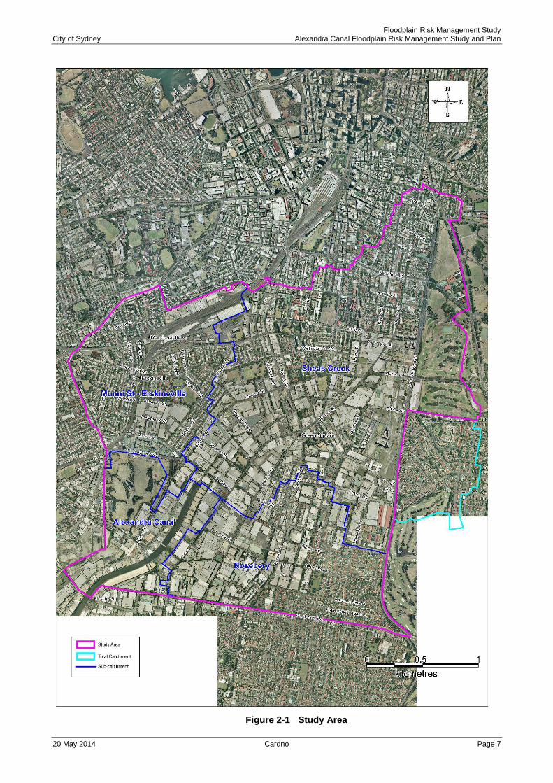
2 Catchment Description
The Alexandra Canal catchment covers 1,141ha or 43% of City of Sydney Local Government area,
including suburbs of Alexandria, Beaconsfield, Erskineville, Eveleigh, Moore Park, Redfern,
Rosebery, Surry Hills, Waterloo and Zetland. Approximately 93% of the total catchment area is
within the City of Sydney, with the remaining 7% being shared with the City of Botany Bay,
Marrickville and Randwick Councils.
The catchment and study area are shown in Figure 2-1.
Drainage systems consisting of open channels, covered channels, in-ground pipes, culverts and
pits convey runoff from the catchment to Alexandra Canal which discharges into the Cooks River.
The majority of the trunk drainage system is owned by Sydney Water Corporation, with the feeding
drainage systems primarily owned by Council.
The majority of the catchment is fully developed and consists predominantly of medium to high-
density housing, commercial and industrial development with some large open spaces that include
Moore Park Playing Fields, Moore Park Golf Course, The Australian Golf Course, Sydney Park,
Redfern Park, Waterloo Park and Alexandria Park.
Flooding throughout the catchment is a combination of overland flow and mainstream flooding.
Mainstream flooding issues tend to occur around Alexandra Canal and the open channels in the
study area. Examples of this type of flooding occur at the channel that runs between Alexandra
Canal and Bowden Street, the channel near Euston Road and the channel at South Sydney
Corporate Park. Elsewhere, flooding is primarily a result of overland flow and the capacity of the
stormwater network and overland flowpaths.
A feature of the catchment is the prevalence of ‘trapped’ low points. These areas, due to
topographical and development constraints, result in significant ponding and flooding of properties
and roads. In a number of these locations, the only way for water to escape is via the pit and pipe
system. Examples of these ponding areas include the Coulson Street sag, Joynton Avenue and
the ponding upstream of Erskineville Oval.
Floodplain Risk Management Study City of Sydney Alexandra Canal Floodplain Risk Management Study and Plan
20 May 2014 Cardno Page 7
Figure 2-1 Study Area

Floodplain Risk Management Study City of Sydney Alexandra Canal Floodplain Risk Management Study and Plan
20 May 2014 Cardno Page 8
3 Available Data
3.1 Previous Studies and Reports
3.1.1 Alexandra Canal Catchment Flood Study
The draft Alexandra Canal Catchment Flood Study (Cardno, 2013) is the key input study to the
FRMSP. The primary objective of this study was to define the flood behaviour in the study area,
including both mainstream and overland flooding. An extensive data compilation and review was
undertaken for the study and included a review of a number of previous studies, together with
collection of available rainfall records and survey data.
A detailed 1D/2D flood model was established to describe the flooding behaviour throughout the
study area. This model incorporates all pits and pipes from data provided by the City of Sydney
and has a 4 metre grid resolution. Hydrological modelling was undertaken through the application
of the Direct Rainfall methodology.
The models were calibrated and verified against four historical storms; November 1984, January
1991, April 1998 and February 2001. The results of the calibration and verification showed that the
model was capable of reproducing the observations from those events, providing confidence in the
overall modelling results.
Using the established models, the study has determined the flood behaviour for the 100 year ARI,
20 year, 10 year, 5 year, 2 year and 1 year ARI events as well as the Probable Maximum Flood
(PMF). The primary flood characteristics reported for the design events considered include depths,
levels and velocities. The study has also defined the Provisional Flood Hazard for flood-affected
areas.
Following a review that was undertaken in conjunction with this study, some minor updates were
undertaken to the modelling for the flood study, and a revised draft was provided to Council. The
key changes that occurred in the modelling are:
Modification of the terrain in the model between Nobbs Lane and Parkham Lane. This
localised area was under construction at the time that the LiDAR was collected, and
therefore did not suitably represent the storage in this area.
Model terrain at Erskineville railway station was revised to refine the representation of
overland flowpaths in the vicinity.
Refinement of hydraulic parameters along Sheas Creek concrete drainage channel.
The above changes were made and incorporated into the updated draft. It is noted that these
resulted in only minor localised changes to flood model results to the previous draft.
3.1.2 Green Square – West Kensington Floodplain Risk Management Study & Plan
The relevant documents from the Green Square West Kensington Study are:
Green Square – West Kensington Floodplain Risk Management Study, Public Exhibition
Draft, February 2011, by WMA Water
Green Square Catchment Floodplain Risk Management Plan, Final Draft, May 2013, by
WMA Water
These two documents overlap a part of the study area for the current project, incorporating the
eastern part of the Sheas Creek Catchment, inclusive of the Green Square redevelopment area.

Floodplain Risk Management Study City of Sydney Alexandra Canal Floodplain Risk Management Study and Plan
20 May 2014 Cardno Page 9
The studies identified a number of options for floodplain management and prioritised these options
for implementation into a plan. This is similar to the current process undertaken for the study.
Whereas the Green Square West Kensington Studies focused on a portion of the catchment, the
current study overviews a much larger study area within the City of Sydney LGA. The measures
identified in the Green Square West Kensington studies have been reviewed in conjunction with
the identification of options in the current study.
3.1.3 Additional Studies
A number of additional studies have been conducted regarding the Alexandra Canal Catchment.
These studies were completed prior to the undertaking of the Flood Study (Cardno 2013) and were
reviewed and incorporated into the Flood Study (where relevant). These studies include:
Green Square Town Centre Flood Mitigation Option Report, 16 July 2008 by Cardno
Green Square Town Centre Flood Mitigation Option Report Addendum, 12 July 2012 by
Cardno
Green Square Town Centre Floodplain Risk Management Plan, 13 July 2012 by Cardno
The Liveable Green Network:
o Volume 1 - Liveable Green Network Strategy and Master Plan Report, draft April
2011
o Volume 2 – Network Development Assessment, draft April 2011
o Volume 3 – Background Research and Case Studies, draft April 2011
Ashmore Precinct Structure Plan Flooding and WSUD Assessment, February 2006 by
Cardno
Ashmore Street Masterplan Flood Assessment, 16 October 2008 by Cardno
3.2 Survey Information
Council provided aerial laser scanning (ALS) ground levels surveyed in 2007 and 2008 for the
entire catchment. Generally, the accuracy of the ALS data is +/- 0.15m to one standard deviation
on hard surfaces.
Additional field survey was undertaken as part of the Flood Study (Cardno, 2013) by Cardno’s
surveyors to provide additional detail for the development of the flood model. This included cross-
sections of some open-channels, bathymetry of Alexandra Canal, and historical flood level
observations.
3.2.1 Floor Level Survey
Detailed survey of building floor levels within the flood inundation extent was conducted in March-
April 2013. A total of 1820 floor levels were surveyed:
429 by Council in St Peters, Alexandria, Beaconsfield, Rosebery and Zetland; and
1391 by Cardno in St Peters, Erskineville, Waterloo, Redfern, and Surry Hills.
This information has been provided separately to Council for privacy reasons and is thus not
included in this Report.
3.3 GIS Data
City of Sydney Council provided Geographic Information System (GIS) data for preparing the
Alexandra Canal Catchment Flood Study model and reporting. The data included:

Floodplain Risk Management Study City of Sydney Alexandra Canal Floodplain Risk Management Study and Plan
20 May 2014 Cardno Page 10
Pit and pipe data
Cadastre
1m and 2m Land Information Centre (LIC) contours
Aerial photography (2006)
Road centrelines
Field survey of more than 4500 pits and over 4000 pipes was undertaken by Cardno’s surveyors
(separate to this study) to provide a detailed database of the locations and dimensions of all
Council’s pits and pipes within the entire LGA. Invert and surface levels of pits was determined
from airborne laser scanning (ALS) levels and details measured directly during survey. This
information was collated during the Flood Study (Cardno, 2013).
3.4 Site Inspections
Detailed site inspections of the study area were conducted on numerous occasions during the
Flood Study as well for the FRMSP and during the assessment for GSTC and individual
developments. The site visits provided the opportunity to review flood issues identified as part of
the Flood Study (Cardno, 2013) and identify and review the feasibility of potential flood
management strategies.

Floodplain Risk Management Study City of Sydney Alexandra Canal Floodplain Risk Management Study and Plan
20 May 2014 Cardno Page 11
4 Consultation
4.1 Community Consultation
The community consultation undertaken as part of the FRMS built on the consultation undertaken
as part of the Flood Study (Cardno, 2013). The purpose of the Flood Study (Cardno, 2013)
consultation was to inform the community about the study and gain an understanding of the
community’s experience with historical flooding in the catchment.
The purpose of the more recent consultation undertaken as part of this FRMS was to inform the
community about the study, identify community concerns and attitudes, to gather information from
the community on potential options for the floodplain and to develop and maintain community
confidence in the study results.
The community consultation consisted of:
A community brochure and survey;
A press release; and
Public meetings.
4.1.1 Community Brochure and Survey
A community information brochure and questionnaire was prepared and distributed in April 2013 as
attached in Appendix A. The questionnaire sought information on people’s recollection of flooding
in the catchment and feedback on potential flood management options. It was mailed to 5,893
properties identified as within the floodplain extent (PMF). An email with the questionnaire was
also sent to 165 of the respondents from the questionnaire of the Alexandra Canal Flood Study
(Cardno, 2013). An online version of the questionnaire was included on Council’s website for
public access.
A total of 461 responses were received, primarily as return posted forms, representing a return of
approximately 8% of the direct mailed quantity. Of these responses, 402 (88%) were from
residents and 53 (11%) were from business. Four respondents did not specify their status.
Property Information
The majority of respondents to the questionnaire are from owner occupied residential properties as
summarised in Table 4-1. Properties are occupied by a tenant in about 19% of the responses and
business accounted for approximately 8%. Some respondents selected multiple descriptions for
their property.
Table 4-1 Property Ownership
All Responses Residential Responses
Owner Occupied 329 (72%) 318
Occupied by a tenant 88 (19%) 76
Business 37 (8%) 6
Not Specified 4 (1%) 2
A high proportion of respondents live within apartments or freestanding houses, about 46% and
39% respectively, as listed in Table 4-2. The catchment has particular property types that
dominate particular areas, for example apartment buildings are predominant in the new
redevelopment areas and industrial / commercial properties may be concentrated in the lower

Floodplain Risk Management Study City of Sydney Alexandra Canal Floodplain Risk Management Study and Plan
20 May 2014 Cardno Page 12
reaches of the catchment. Potentially apartment blocks would likely provide refuge from
floodwaters at the higher levels within the building.
Table 4-2 Property Description
Structure Description All Responses
Apartment 213 46.4%
Dual Occupancy 4 0.9%
Dual Occupancy & Commercial 2 0.4%
Freestanding house 179 39.0%
Industrial & Commercial 57 12.4%
Not Specified 4 0.9%
The amount of time that respondents have lived or worked in the catchment is important to
evaluate their experience of flood events. Awareness of flooding is dependent on whether a flood
event has occurred recently and its magnitude as well as the respondent’s location within the
floodplain. For this Study, there have been some recent storm events resulting in some flooding
and the questionnaire distribution was focussed on properties within the main flood extents.
Of the residents who responded, 60% had resided at their current address less than 10 years,
whilst 35% had occupied their current residences greater than 10 years. Fifty-five percent of
business respondents had occupied their property less than 10 years, whilst 41% had been there
longer than 10 years.
Figure 4-1 shows the proportion of respondents within ranges for their years within the catchment
at their current address.
Figure 4-1 Years of Residence
Demographic Information
The age and languages of people within the catchment is important for flood planning within the
catchment. Education and potential evacuation plans would take into consideration the age of
residents noting potential mobility issues and languages used to provide effective communication.
Respondents to the questionnaire may not be a true representation of the whole but does indicate
a cross-section of the community. This information should be used in conjunction with the general
demographic review undertaken in Section 7.
0%
5%
10%
15%
20%
25%
30%
0 to 2Years
3 to 5Years
6 to 10Years
11 to 15Years
16 to 20Years
21 to 30Years
31 to 50Years
> 50 Years NotAnswered
Perc
en
tag
e o
f P
rop
ert
ies f
or
Each
Year
Peri
od
Number of Years within Catchment
Residential Industrial & Commercial Not Specified
Floodplain Risk Management Study City of Sydney Alexandra Canal Floodplain Risk Management Study and Plan
20 May 2014 Cardno Page 13
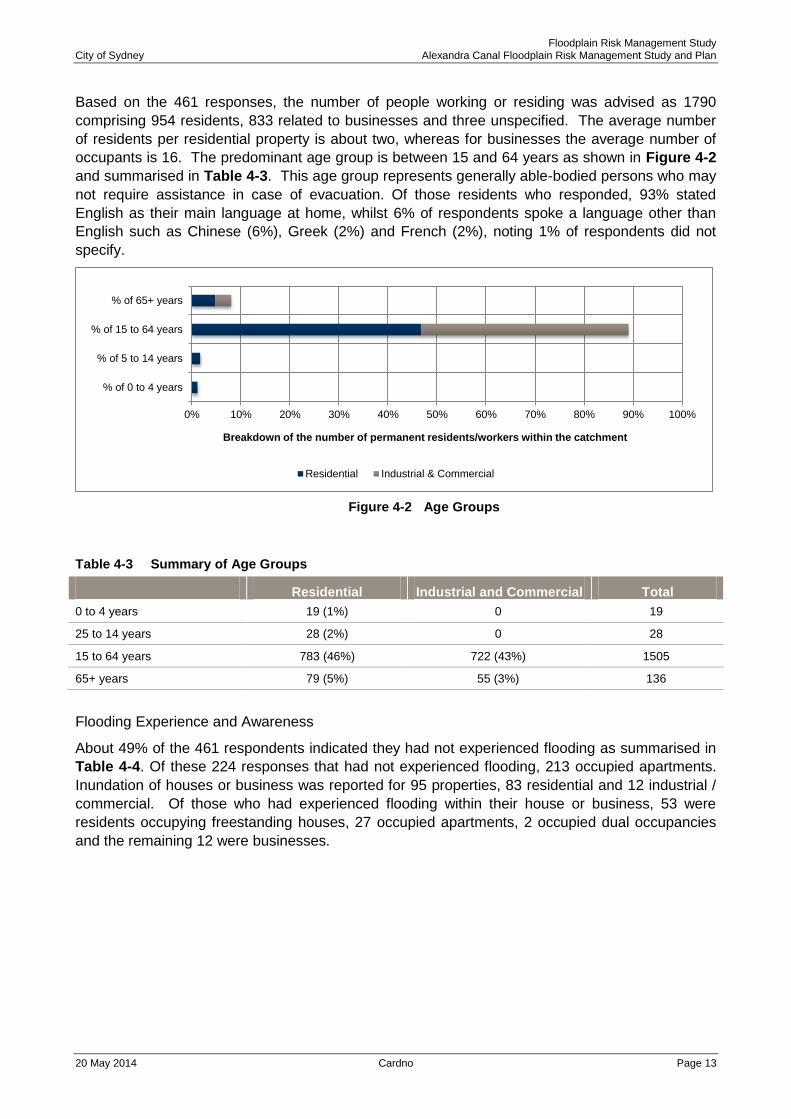
Based on the 461 responses, the number of people working or residing was advised as 1790
comprising 954 residents, 833 related to businesses and three unspecified. The average number
of residents per residential property is about two, whereas for businesses the average number of
occupants is 16. The predominant age group is between 15 and 64 years as shown in Figure 4-2
and summarised in Table 4-3. This age group represents generally able-bodied persons who may
not require assistance in case of evacuation. Of those residents who responded, 93% stated
English as their main language at home, whilst 6% of respondents spoke a language other than
English such as Chinese (6%), Greek (2%) and French (2%), noting 1% of respondents did not
specify.
Figure 4-2 Age Groups
Table 4-3 Summary of Age Groups
Residential Industrial and Commercial Total
0 to 4 years 19 (1%) 0 19
25 to 14 years 28 (2%) 0 28
15 to 64 years 783 (46%) 722 (43%) 1505
65+ years 79 (5%) 55 (3%) 136
Flooding Experience and Awareness
About 49% of the 461 respondents indicated they had not experienced flooding as summarised in
Table 4-4. Of these 224 responses that had not experienced flooding, 213 occupied apartments.
Inundation of houses or business was reported for 95 properties, 83 residential and 12 industrial /
commercial. Of those who had experienced flooding within their house or business, 53 were
residents occupying freestanding houses, 27 occupied apartments, 2 occupied dual occupancies
and the remaining 12 were businesses.
0% 10% 20% 30% 40% 50% 60% 70% 80% 90% 100%
% of 0 to 4 years
% of 5 to 14 years
% of 15 to 64 years
% of 65+ years
Breakdown of the number of permanent residents/workers within the catchment
Residential Industrial & Commercial

Floodplain Risk Management Study City of Sydney Alexandra Canal Floodplain Risk Management Study and Plan
20 May 2014 Cardno Page 14
Table 4-4 Flood Affectation of Respondents
Total
Responses
Residential
Responses
Industrial/Commercial
Responses
Yes, floodwaters entered my house/business 95 83 12
Yes, floodwaters entered my yard/surrounds of my business
97 84 13
Yes, the road was flooded and I couldn't get to my car
86 74 12
Yes, other parts of my neighbourhood were flooded
135 124 11
No, I haven't experienced flooding 224 195 29
No Specified 5 2 3
Respondents noted locations where they had witnessed localised flooding, including:
Buckland Street, Alexandria;
Maddox Street, Alexandria;
Brandling Street, Alexandria;
O’Riordan Street, Alexandria;
Intersection of Mitchell Road and Huntley Street, Alexandria;
Pleasant Avenue, Erskineville;
Smiths Lane, Erskineville;
George Street, Erskineville;
Boronia Street Redfern;
Chalmers Street, Redfern;
Botany Road, Waterloo;
Joynton Avenue, Zetland; and
Marshall Street, Surry Hills.
Historical flooding was noted to have occurred in Alexandria in 1998, Waterloo in 2003, and
localised flooding in Redfern (2010 and 2013) and Rosebery (2007).
Photographs of flooding in the catchment provided by residents are shown in Appendix A.
Flood Management
Nine approaches to flood management were presented in the questionnaire for respondents to list
a preference rating for each approach. A rating of 1 to 5 was presented, with 5 being the most
preferred and 1 being least preferred. Of the 461 respondents, 407 were from residential
properties and 54 from commercial / industrial properties.
Figure 4-3 shows the flood management approaches in order of preference based on the average
of the response ratings. Also shown are the extents of the 25th percentile and 75th percentile
scores which show the range within which at least half of the ratings were given.
Table 4-5 summarises the average preference rating of all responses as well as the rating with the
highest individual response and the amount that did not specify a preference rating.

Floodplain Risk Management Study City of Sydney Alexandra Canal Floodplain Risk Management Study and Plan
20 May 2014 Cardno Page 15
Figure 4-3 Average Rating for Flood Management Approaches

Floodplain Risk Management Study City of Sydney Alexandra Canal Floodplain Risk Management Study and Plan
20 May 2014 Cardno Page 16
Table 4-5 Flood Management Approach Rating Summary
The two highest rated approaches; pit / pipe upgrades and improved flowpaths, both aim to reduce
the potential inundation of roads and properties by constructing additional capacity to convey flood
water to the Canal. Strategic planning and development controls is the highest rated non-structural
approach.
Stormwater harvesting approaches may have limited impact on flood inundation within the
catchment. The potential advantages are minor due to the relative volume of runoff during a flood
event compared to the available storage capacity. Similarly, storages for harvesting may be kept
full following an event to provide water for alternative uses but this does not leave free capacity for
a follow-up storm event.
Levee banks / flood walls and culvert / bridge enlarging are the least favoured approaches,
potentially as other approaches are preferred which would more efficiently convey runoff from the
catchment. These approaches may also reduce the visual amenity of the area. Similarly retarding
/ detention basins were not highly favoured, potentially due to visual impact and loss of open
space.
Flood forecasting and education approaches were ranked as sixth and seventh based on the mean
rating, however they had a wider range of ratings generally indicating that some respondents were
more strongly in favour (or not in favour) of these approaches. The responses do not indicate the
reasons for ratings, however it may be summised that these are ranked lower as they are not
considered to provide a tangible improvement to flood inundation.
The approaches with the highest percentage for ratings of ‘5’ (being most preferred) were pit / pipe
upgrades, strategic planning and stormwater harvesting. Approaches with the highest proportion
of no response, potentially indicating they were not favoured, are non-structural measures and
culvert / bridge enlarging, and levee banks / flood walls.
Approximately 22% of the total respondents recommended other flood management approaches,
most common being maintenance of drains and guttering (litter and debris removal) and improving
Flood Management Approach All Responses Residential Responses
Average Rating Rating with Highest Response
Not Answered
Pit and pipe upgrades 4.0 5 (31%) 153 (38%)
Improved flood flow paths 4.0 5 (18%) 154 (38%)
Strategic planning and flood related development controls
4.0 5 (26%) 175 (44%)
Stormwater harvesting, such as rainwater tanks
3.8 5 (31%) 131 (33%)
Retarding or detention basins 3.5 5 (18%) 153 (38%)
Flood forecasting, flood warnings, evacuation planning and emergency response measures
3.4 5 (17%) 176 (44%)
Education of the community, providing awareness of potential hazards
3.2 5 (14%) 175 (44%)
Culvert/bridge enlarging 3.2 3 (17%) 179 (45%)
Levee banks or flood walls 2.7 3 (16%) 177 (44%)

Floodplain Risk Management Study City of Sydney Alexandra Canal Floodplain Risk Management Study and Plan
20 May 2014 Cardno Page 17
stormwater drainage capacity (noting that this is the outcome of several of the presented
approaches).
Generally, responses to the questionnaire potentially indicate a preference for flood management
approaches that will result in tangible reductions to flood inundation in the catchment, such as
improved pit and pipe drainage.
4.2 Floodplain Committee and Stakeholder Consultation
The floodplain committee provides an important role in assisting Council in the development and
implementation of the Floodplain Management Plan. It comprises of various agency and
community representatives. The Cardno project team have reported to the committee and
undertaken workshops with the committee and additional stakeholders at key stages of the study.
Inception Meeting (15th March 2012): An overview of the project purpose, scope and
methodology was presented to the Committee. Key issues and ideas regarding the
direction of the study were raised by the committee for consideration by Cardno and
Council.
Floodplain Management Committee Meeting (6th June 2012): An overview of the risk
management study and plan to date including previous studies conducted by Cardno. A list
of management and identifiable options were presented by Cardno for consideration by the
committee.
Floodplain Management Committee Meeting (5th December 2012): This meeting outlined
the floodplain risk management process including tasks to be conducted and the results
from this study. An extensive and detailed list of processes was provided by Cardno to be
considered by the committee.
Council Internal Workshop (15th April 2013): A workshop was conducted by Cardno with
several Council staff providing details of project stakeholders, identification of additional
options and the proposed Multi-Criteria Assessment.
Floodplain Management Committee Workshop (29th April 2013): This workshop was
undertaken as a follow-up meeting from the previous Council internal workshop. The
workshop further reviewed potential floodplain management options, the results of
preliminary options assessments and further developed the Multi-Criteria Assessment.
The outcomes of the workshops on the 14th and 29th April are included in Appendix B.
4.3 Public Exhibition
The Draft Flood Study, Draft Floodplain Risk Management Study and Draft Floodplain Risk
Management Plan were placed on public exhibition for a period of four weeks from
28 October 2013 to 25 November 2013. This allowed the community and interested parties to
review the draft Study and submit comments on the Study and its outcomes.
The exhibition documents were publicly available at the One Stop Shop (Town Hall House),
Redfern Neighbourhood Service Centre, Green Square Neighbourhood Service Centre, and
Council’s Website (www.cityofsydney.nsw.gov.au). Public notices were advertised on
commencement of the exhibition in the Sydney Morning Herald, Central Sydney Magazine, Inner
West Courier, and Southern Courier.
A community drop-in session was held on Wednesday 20 November 2013 at the Alexandria Town
Hall, 73 Garden Street, Alexandria. Officers from Council, Office of Environment and Heritage and
Cardno were present and available to answer community questions.
Floodplain Risk Management Study City of Sydney Alexandra Canal Floodplain Risk Management Study and Plan
20 May 2014 Cardno Page 18
A notification of the public exhibition and an invitation to attend Community Information &
Feedback Session was:
Mailed to 130 stakeholders who had participated in flood surveys;
Emailed to 560 stakeholders who had participated in flood surveys; and
Emailed to local community and residents action groups: Cooks River Alliance, Alexandria
Residents Action Group, Friends of Victoria Park, Surry Hills Neighbourhood Centre,
Friends of Erskineville and Rosebery Residents Action Group.
A hard-copy display for the project was included at Neighbourhood Service Centres. The
community drop-in session was promoted via Council’s Twitter page with two tweets on the day of
the community drop in session.
One resident telephone enquiry was received prior to the community drop-in session regarding
proposals to upgrade the trunk drainage at the rear of properties facing Newtown Street,
Alexandria. The resident was concerned about the potential for a future upgrade to impact the
structural stability of his home. City staff advised that the exhibited studies and plan are a long term
strategy, and that an upgrade to the trunk drainage in the location of concern would not occur for at
least 10 years and could be up to 50 years away. The resident was concerned about short term
works and was satisfied with this response.
There were three attendees at the community drop-in session and three issues were raised:
A comment was made about historical flooding in Harcourt Parade, Rosebery and seeking
information about planned measures in this area. The content of the studies and plans was
then reviewed. No further action is necessary.
A general question was asked regarding development in the Alexandria area and ensuring
that there were no adverse impacts arising from future development. A response was
provided to the satisfaction of the attendee. No further action.
A general question was asked regarding opportunities for stormwater reuse as a flood
mitigation measure. A response was provided to the satisfaction of the attendee. No further
action.
The public exhibition page on Council’s website received 170 page views. At closure of the
exhibition period one written submission had been received. The submission was made using the
resident comment sheet provided for the community drop-in session. The submission indicated
general support for the Study and raised no further issues.

Floodplain Risk Management Study City of Sydney Alexandra Canal Floodplain Risk Management Study and Plan
20 May 2014 Cardno Page 19
5 Existing Flood Behaviour
5.1 Flood Study
A detailed 1D/2D flood model was established as part of the Flood Study (Cardno, 2013) to
describe the flooding behaviour throughout the study area. This model incorporated all pits and
pipes from data provided by the City of Sydney and had a 4 metre grid resolution. Hydrological
modelling was undertaken through the application of the Direct Rainfall methodology.
The models were calibrated and verified against four historical storms; November 1984,
January 1991, April 1998 and February 2001. November 1984 was approximately larger than a
100 year ARI event, while April 1998 was in the order of a 10 year ARI event. The other two events
were smaller, with January 1991 roughly a 20 – 50 year ARI event, and February 2001 less than a
1 year ARI event. The calibration events were chosen through a combination of both their
magnitude, together with the quantity of flood observations from the storm.
The results of the calibration and verification showed that the model was capable of reproducing
the observations from those events, providing confidence in the overall modelling results. The
models were further verified against the previous studies that have been undertaken within the
catchment.
Using the established models, the study has determined the flood behaviour for the 100 year ARI,
20 year, 10 year, 5 year, 2 year and 1 year ARI events together with the Probable Maximum Flood
(PMF). The primary flood characteristics reported for the design events considered include depths,
levels and velocities. The study has also defined the Provisional Flood Hazard for flood-affected
areas.
The 100 Year ARI and PMF extents are shown in Figures 5-1 and 5-2. The flooding behaviour
across the catchment is described in the following section with regards to each of the sub-
catchments as shown in Figure 5-3.

Floodplain Risk Management Study City of Sydney Alexandra Canal Floodplain Risk Management Study and Plan
20 May 2014 Cardno Page 20
Figure 5-1 100 Year ARI Peak Flood Depths

Floodplain Risk Management Study City of Sydney Alexandra Canal Floodplain Risk Management Study and Plan
20 May 2014 Cardno Page 21
Figure 5-2 PMF Peak Flood Depths

Floodplain Risk Management Study City of Sydney Alexandra Canal Floodplain Risk Management Study and Plan
20 May 2014 Cardno Page 22
Figure 5-3 Sub-Catchments

Floodplain Risk Management Study City of Sydney Alexandra Canal Floodplain Risk Management Study and Plan
20 May 2014 Cardno Page 23
5.2 Flooding Behaviour
5.2.1 Munni Street Sub-Catchment
The Munni Street catchment discharges into Alexandra Canal through a concrete channel near
Burrows Road. The catchment incorporates a mix of residential and industrial.
The upper parts of the catchment are primarily residential and townhouses. The flowpaths in the
upper portions are primarily overland flow, and proceed between the houses and across the roads
in these areas. Some ponding occurs north of Macdonaldtown Station and the rail line, due to the
obstruction that the rail line creates in this area on Holdsworth Street. Ponding in this area is in the
order of 1.7 metres in the 100 year ARI event.
To the west of the Illawarra and Eastern suburbs rail line, an overland flow path forms a ponding
and backwater area on Macdonald Street due to the control of the rail underpass on Macdonald
Street. Ponding in this area is in the order of 0.8 metres in the 100 year ARI event.
A significant isolated ponding area occurs north of Erskineville Oval and Copeland Street. This
area is controlled by the high point and limited capacity of Fox Avenue, as well as from the
obstruction of the oval itself. Ponding upstream of this area reaches depths in excess of 1 metre in
a 100 year ARI event and affects a number of residential properties.
The industrial area in the centre of the Munni Street catchment is inundated by overland flowpaths
which arrive from Macdonald Street (to the west of the rail line) and from the north of Ashmore
Street. This overland flow accumulates at a trapped low point at the intersection of Coulson Street
and Mitchell Avenue. At this location, the estimated 100 year ARI depths are in the order of
0.9 metres, and increase to around 1.3 metres further west of the intersection on Coulson Street.
This ponding area is controlled by the high point which runs between Sydney Park Road and
Huntley Street.
5.2.2 Sheas Creek Sub-Catchment
The Sheas Creek catchment drains to a main open channel at Bowden Street conveying runoff to
Alexandra Canal south of Huntley Street. Three subsections of the catchment drain toward
Bowden Street – Alexandria and Macdonaldtown Branch, Main Branch, and Victoria Branch.
Lowpoints in the roads of the Alexandria and Macdonaldtown Branch result in ponding at Cope
Street near Wellington Street, Buckland Street near Gerard Street and at Park Road.
In the Main Branch subsection, a series of lowpoints in roads show ponding of runoff in frequent
storm events. These include Phelps Street, Arthur Street, Boronia Street near Marriott Street,
along Baptist Street to Phillip Street, Phillip Street near Walker Street, Chalmers Street and Hunter
Street. In a larger storm event, runoff flows out of these ponded areas primarily along roads from
the north-east of the study area to the open channel at Wyndham Street.
The upstream areas of the Victoria Branch are located outside the study area in West Kensington
to the east of South Dowling Street. Runoff is conveyed generally towards Joynton Avenue where
box culverts are located to convey water through the area of the proposed Green Square Town
Centre towards Mandible Street. Ponding occurs in lowpoints in roadways during frequent ARI
events at Joynton Avenue, Botany Road near Bourke Street and O’Riordan Street near Johnson
Street. In a larger storm event, a relatively contiguous flowpath along roads is evident from
Lachlan Street and South Dowling Street along Joynton Avenue and O’Riordan Street to the open
channels.
5.2.3 Rosebery Sub-Catchment
Rosebery sub-catchment is comprised of several sections which drain either to Alexandra Canal or
out of the study area south of Gardeners Road. A relatively small portion in the south-eastern

Floodplain Risk Management Study City of Sydney Alexandra Canal Floodplain Risk Management Study and Plan
20 May 2014 Cardno Page 24
corner of the study area, bounded by Dalmeny Avenue and Asquith Avenue, drains toward the
south across Gardeners Road. The portion of the catchment bounded by Birmingham Street,
Gillespie Avenue and Botany Road also drains across Gardeners Road into the City of Botany Bay
LGA.
The majority of the Rosebery sub-catchment comprises the Doody Street drainage area and drains
towards the open channel located between properties from Doody Street to Bourke Road. Ponding
of runoff is particularly evident at lowpoints in the road at Botany Road near Collins Street, Morley
Avenue near Jones Lane, Harcourt Parade near Durdans Avenue, and Ralph Street near Shirley
Street.
5.2.4 Alexandra Canal Sub-Catchment
Rainfall on Sydney Park is conveyed to the ponds within the Park and excess runoff may flow
towards Euston Road in large ARI events. This sub-catchment generally drains towards Burrows
Road which has several lowpoints along its length that are drained by pit and pipe systems.
Ponding of runoff occurs in the lowpoints of Euston Road and Burrows Road. In large ARI events,
inundation to properties may result from overland flows from upstream areas and or elevated levels
in Alexandra Canal itself.
5.3 Historical Flooding
Several significant flooding events have occurred within the Alexandra Canal Catchment. Rainfall
analysis would indicate that the most significant flood events occurred in the 1980s and 1990s.
However, the majority of the respondents to the community survey undertaken as part of the Flood
Study (Cardno, 2013) had only resided in the catchment for less than 10 years. Therefore, little
information relating to historical flood events is available as a result of the survey.
Rainfall analysis identified the following key historical events in the catchment as summarised in
Table 5-1:
8 November 1984 (Approximately 100 Year ARI);
26 January 1991 (Approximately 20 to 50 Year ARI);
10 April 1998 (Approximately 10 to 20 Year ARI); and
1 March 28 February 2001 (Approximately 1 Year ARI).
Table 5-1 Approximate ARI of Historical Rainfall Events (Observatory Hill – 66062)
Storm Event Details Duration
30 mins 60 mins 90 mins 2 hour 3 hour
8th November 1984 Intensity (mm/h) 180 119 104 90 64
Approx. ARI >100y >100y >100y >100y >100y
26th January 1991 Intensity (mm/h) 120 65 43 32 20
Approx. ARI ~50y 10-20y 5-10y 2-5y 1-2y
10th April 1998 Intensity (mm/h) 84 67 48 37 35
Approx. ARI 5-10y 10-20y ~10y 5-10y ~20y
28th February 2001 Intensity (mm/h) 44 22 15 11 8
Approx. ARI <1y <1y <1y <1y <1y

Floodplain Risk Management Study City of Sydney Alexandra Canal Floodplain Risk Management Study and Plan
20 May 2014 Cardno Page 25
5.4 Flood Hazard
Flood hazard can be defined as the risk to life and limb caused by a flood. The hazard
caused by a flood varies both in time and place across the floodplain.
5.4.1 Provisional Flood Hazard
Provisional flood hazard is determined through a relationship developed between the depth and
velocity of floodwaters (Figure L2, NSW Government, 2005). The Floodplain Development Manual
(2005) defines two categories for provisional hazard - High and Low.
The provisional flood hazard was defined as part of the Flood Study (Cardno, 2013) using an in-
house developed program, which utilises the model results of flood depths and velocity. Provisional
flood hazard mapping was prepared for the PMF, 100 Year ARI and 5 Year ARI events as shown
in Figures 5-4 to 5-6.

Floodplain Risk Management Study City of Sydney Alexandra Canal Floodplain Risk Management Study and Plan
20 May 2014 Cardno Page 26
Figure 5-4 PMF Provisional Flood Hazard
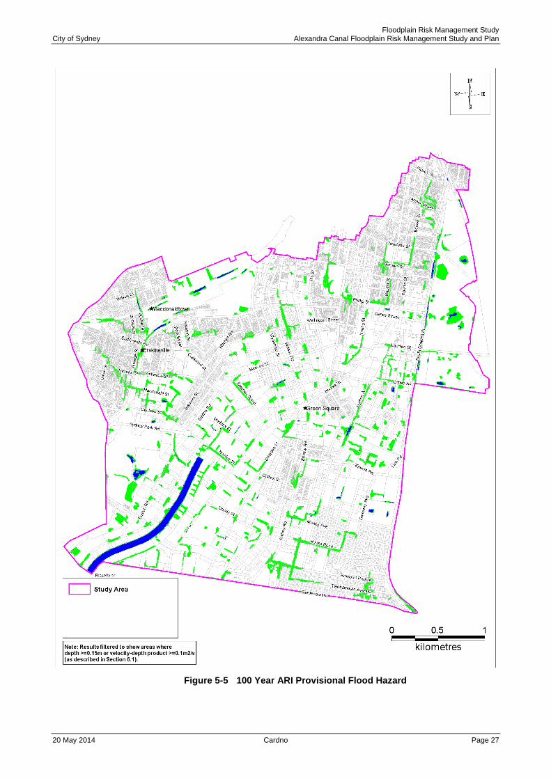
Floodplain Risk Management Study City of Sydney Alexandra Canal Floodplain Risk Management Study and Plan
20 May 2014 Cardno Page 27
Figure 5-5 100 Year ARI Provisional Flood Hazard
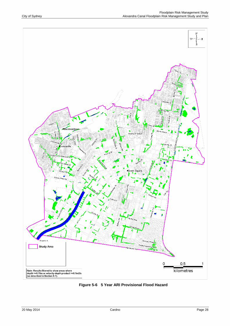
Floodplain Risk Management Study City of Sydney Alexandra Canal Floodplain Risk Management Study and Plan
20 May 2014 Cardno Page 28
Figure 5-6 5 Year ARI Provisional Flood Hazard

Floodplain Risk Management Study City of Sydney Alexandra Canal Floodplain Risk Management Study and Plan
20 May 2014 Cardno Page 29
5.4.2 True Flood Hazard
Provisional flood hazard categorisation is based around a function of velocity and depth,
and does not consider a range of other factors that influence the “true” flood hazard. In addition
to water depth and velocity, other factors contributing to the true flood hazard include:
Size of the flood,
Effective warning time,
Flood readiness,
Rate of rise of floodwaters,
Duration of flooding,
Ease of evacuation,
Effective flood access, and
Type of development in the floodplain.
The flood hazard in areas both within the floodplain and those areas outside of the floodplain
impacted by flooding have been reviewed against the above listed factors. True Flood Hazard
mapping has been undertaken for the 5 Year ARI, 100 Year ARI and the PMF flood event.
Size of Flood
The size of a flood and the damage it causes varies from one event to another. For the purposes of
this Floodplain Risk Management Study, provisional flood hazard has been assessed for the
5 Year, 100 Year ARI and PMF events which produce the peak water levels in the floodplain. True
hazard has also been assessed for the 5 and 100 Year ARI events as well as the PMF event.
Effective Warning Time
The effective warning time can also be described as the actual time for people to undertake
appropriate actions (such as lift or transport belongings and/or evacuate). This time is generally
always less than the total warning time available to emergency agencies. This is because of the
time needed to alert people to the imminence of flooding and to have them begin effective property
protection and/or evacuation procedures.
The critical duration storm for the study area is generally a 60 minute duration event for the
100 year ARI. The peak duration for the PMF event is approximately a 15 minute duration event.
The peak of the flow would therefore generally occur at various locations within the catchment
within15 minutes to 2 hours from the start of the rainfall. Therefore, there is little to no warning
time throughout the catchment.
However, it is noted that all areas within the catchment are exposed to similar flood response
times, and therefore it can be considered that no area within the catchment is any more at risk than
another.
The exception to this is overfloor flooding. Due to the critical durations within the catchment, if a
property experiences overfloor flooding this will occur within a very short timeframe. This is
considered to pose a hazard to these properties, and these should be included in the True Hazard
Mapping. As summarised in Table 6-5, there are 580 residential properties and 71 commercial
properties and 54 industrial properties with overfloor flooding in the 100 year ARI event. Note that
these have not been shown on the mapping for privacy reasons, but this data has been provided to
Council separately.

Floodplain Risk Management Study City of Sydney Alexandra Canal Floodplain Risk Management Study and Plan
20 May 2014 Cardno Page 30
Flood Readiness
Flood readiness can greatly influence the time taken by flood-affected residents and visitors to
respond in an effective fashion to flood warnings. In communities with a high degree of flood
readiness, the response to flood warnings is generally prompt, efficient and effective.
Flood readiness is generally influenced by the time elapsed since the area last experienced severe
flooding. The major flood events occurred in the catchment were in November 1984 which was
roughly equivalent to a 100 Year ARI event, January 1991 which is approximately 20 to 50 Year
ARI event and April 1998 which is approximately 10 to 20 Year ARI event.
Based on the responses from the resident survey (Section 4), approximately 5-10% of
respondents has been living in the catchment at the time of the 1984 flood event and 1991 flood
event.
The responses from the resident survey suggest that around 49% of the residents are not aware of
flooding in the catchment. This can be both a function of the understanding of overland flooding,
which is commonly associated with stormwater flooding. Furthermore, the short duration of
flooding in the catchment may mean that the flooding occurs when the residents are not at home.
It is assumed that flood awareness of larger floods is likely to be relatively low and no particular
part of the catchment is likely to be any more prepared for a flood than another, thus flood
readiness has not been considered in the preparation of hazard extents.
Rate of Rise of Floodwaters
The rate of rise of floodwaters affects the consequences of a flood. Situations where floodwaters
rise rapidly are potentially far more dangerous and cause more damage than situations where
flood levels increase slowly. Both the catchment and floodplain characteristics affect the rate of
rise.
A rate of rise of 0.5 m/hr has been adopted as indicative of hazardous conditions. However, it is
important to note that a rate of rise greater than 0.5 m/hr on its own is not necessarily hazardous.
For instance, if the rate of rise is very high but flood depths only reach 200 mm, this is not
considered to pose any greater hazard than slowly rising waters. Therefore, peak flood depths
were considered in conjunction with the rate of rise in identifying hazardous areas.
A flood depth of 500 mm, combined with a rate of rise greater than 0.5 mm/hr was selected as the
trigger depth to identify hazardous conditions. A 500 mm flood depth is well within the range of
available information as to when vehicles become unstable even with no flow velocity (Figure L1;
NSW Government, 2005).
The mapping provided in Figure 5-8 to Figure 5-10, show there are few properties with flow
behaviour of these constraints for the 100 and 5 Year ARI events which are not already selected
by the provisional high hazard criteria. These areas should be considered with regards to flood
planning end emergency response in the catchment.
Duration of Flooding
The duration of flooding or length of time a community, suburb or single dwelling is cut off by
floodwaters can have a significant impact on the costs and disruption associated with flooding.
Flooding durations are generally less than a couple of hours, and as such this is not considered as
a key issue for Alexandra Canal Catchment. Figure 5-7 shows the critical duration for the
catchment in a 100 Year ARI flood event.

Floodplain Risk Management Study City of Sydney Alexandra Canal Floodplain Risk Management Study and Plan
20 May 2014 Cardno Page 31
Figure 5-7 100 Year ARI Critical Duration

Floodplain Risk Management Study City of Sydney Alexandra Canal Floodplain Risk Management Study and Plan
20 May 2014 Cardno Page 32
Ease of Evacuation
The levels of damage and disruption caused by a flood are also influenced by the difficulty of
evacuating flood-affected people and property. Evacuation may be difficult because of a number of
factors, including:
The number of people requiring assistance;
Mobility of people;
Time of day; and
Lack of suitable evacuation equipment.
The duration of flooding in the catchment is short, as noted above. Therefore, evacuation issues
for the majority of the catchment are not considered to be an issue in a 100 Year ARI. Considering
the factor of the number of people requiring assistance and mobility of people, the Waterloo Public
School and Alexandria Park Community School are mapped in PMF event because the flood free
access are cut off by flood waters.
Effective Flood Access
The availability of effective access routes from flood prone areas can directly influence personal
danger and potential damage reduction measures. Effective access means an exit route that
remains trafficable for sufficient time to evacuate people and possessions.
Flood access issues vary across the catchment. For the purposes of this assessment properties
were identified as being in one of these flood access categories:
Site is flooded and evacuation required through a high hazard flooded roadway,
Site is flooded and evacuation is required through a flooded roadway,
Site is flood free, however all road access is impeded by floodwaters.
The effective flood access mapping shown in Figure 5-8 to Figure 5-10 identify that there are
significant areas within the catchment which do not have effective flood access. In these areas, for
the duration of the flooding, evacuation is generally not recommended. In this type of short
duration flooding, residents are as likely to put themselves in harms way by evacuating rather than
staying indoors.
Type of Development in the Floodplain
The degree of hazard to be managed is also a function of the type of development and resident
mobility. This may alter the type of development considered appropriate in new development areas
and modify management strategies in existing development areas.
The land-use in the Study Area is a mix of residential, commercial and industrial. No schools,
community use buildings, nursing homes or child care centres were identified in a flood inundated
area in a 100 Year ARI event.
5.4.2.2 Outcome of True Hazard Assessment
The outcomes of the true hazard assessment has been mapped in Figure 5-8 to Figure 5-10 for
the PMF, 100 year ARI and 5 year ARI flood event.

Floodplain Risk Management Study City of Sydney Alexandra Canal Floodplain Risk Management Study and Plan
20 May 2014 Cardno Page 33
Figure 5-8 PMF True Hazard
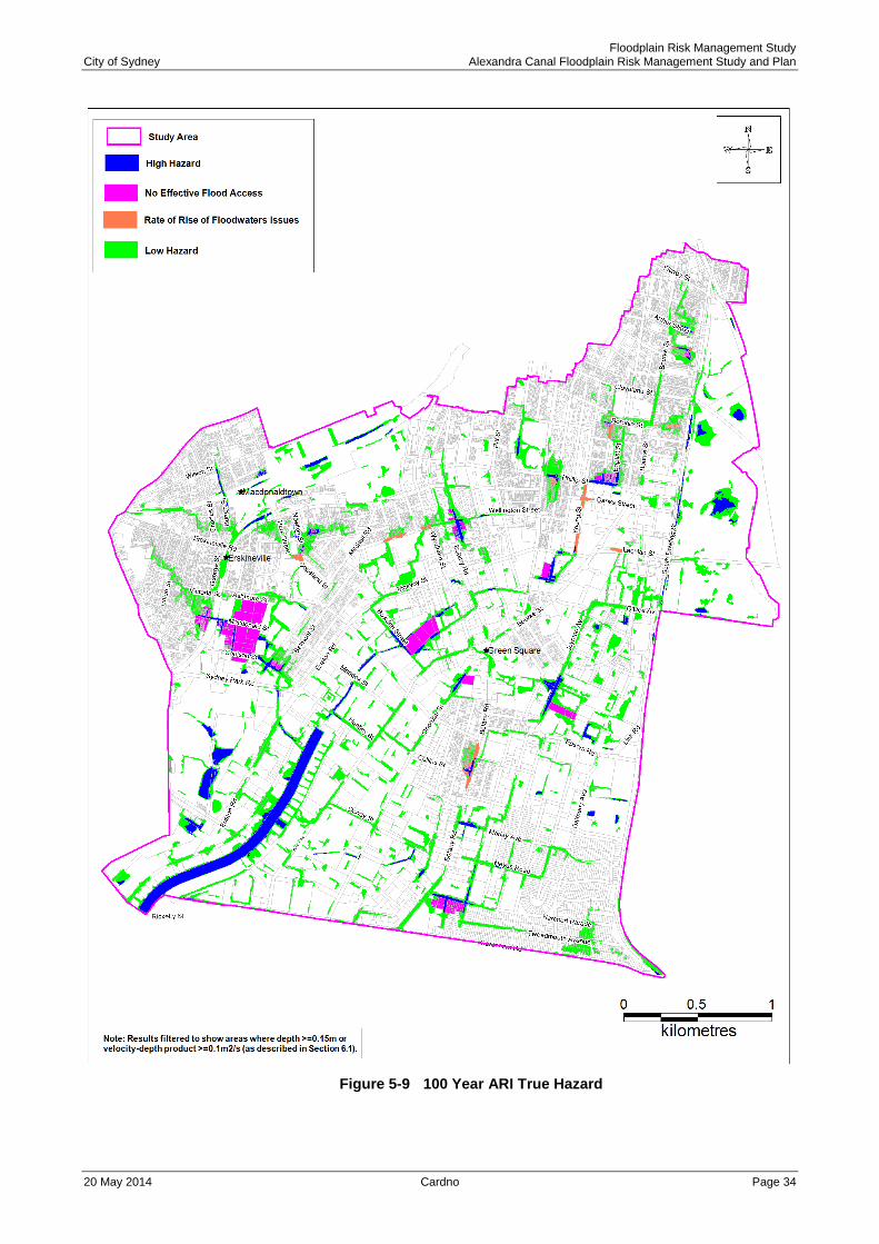
Floodplain Risk Management Study City of Sydney Alexandra Canal Floodplain Risk Management Study and Plan
20 May 2014 Cardno Page 34
Figure 5-9 100 Year ARI True Hazard
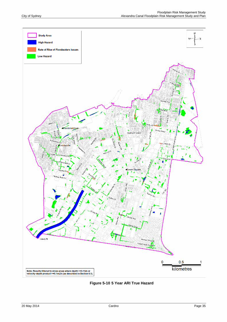
Floodplain Risk Management Study City of Sydney Alexandra Canal Floodplain Risk Management Study and Plan
20 May 2014 Cardno Page 35
Figure 5-10 5 Year ARI True Hazard

Floodplain Risk Management Study City of Sydney Alexandra Canal Floodplain Risk Management Study and Plan
20 May 2014 Cardno Page 36
5.5 Hydraulic Categorisation
While Flood Hazard (described in the sections above) relates to the impact of flooding on
development and people, Hydraulic Categorisation is used to reflect the impact of development
activity on flood behaviour. The Floodplain Development Manual (2005) defines flood prone land to
be one of the following three hydraulic categories:
Floodway – Areas that convey a significant portion of the flow. These are areas that, even
if partially blocked, would cause significant increase in flood levels or a significant
redistribution of flood flows, which may adversely affect other areas.
Flood Storage – Areas that are important in the temporary storage of the floodwater during
the passage of the flood. If the area is substantially removed by levees or fill it will result in
elevated water levels and/or elevated discharges. Flood storage areas, if completely
blocked would cause peak flood levels to increase by 0.1m and/or would cause the peak
discharge to increase by more than 10 percent.
Flood Fringe – Remaining area of flood prone land after Floodway and Flood Storage
areas have been defined. Blockage or filling of this area will not have any significant effect
on the flood pattern or flood levels.
Hydraulic categorisation mapping has been undertaken for the 5 and 100 Year ARI together with
the PMF using the results from the Draft Flood Study (Cardno, 2013).
The criteria used to define floodways and flood storage is described below (based on Howells et al,
2003). It provides a framework for the FRMSP and guides planning for properties potentially
requiring a detailed assessment for future development.
As a minimum, the floodway was assumed to follow the channels from bank to bank. In addition,
the following depth and velocity criteria were used to define a floodway:
Velocity x Depth product must be greater than 0.25 m2/s and velocity must be greater than
0.25 m/s; OR
Velocity is greater than 1 m/s.
Flood storage was defined as those areas outside the floodway, which if completely filled would
cause peak flood levels to increase by 0.1 m and/or would cause peak discharges to increase by
more than 10 percent. The criteria were applied to the model results as described below.
Previous analysis of flood storage in 1D cross sections assumed that if the cross-sectional area is
reduced such that 10 percent of the conveyance is lost, the criteria for flood storage would be
satisfies. To determine the limits of 10 percent conveyance in a cross-section, the depth was
determined at which 10 percent of the flow was conveyed. This depth averaged over several cross-
sections was found to be 0.2m (Howells et al, 2003). Thus the criteria used to determine the flood
storage is:
Depth greater than 0.2m; AND
Not classified as floodway.
The hydraulic categories are shown in Figure 5-11 to Figure 5-13.

Floodplain Risk Management Study City of Sydney Alexandra Canal Floodplain Risk Management Study and Plan
20 May 2014 Cardno Page 37
Figure 5-11 Hydraulic Categories – PMF

Floodplain Risk Management Study City of Sydney Alexandra Canal Floodplain Risk Management Study and Plan
20 May 2014 Cardno Page 38
Figure 5-12 Hydraulic Categories – 100 Year ARI

Floodplain Risk Management Study City of Sydney Alexandra Canal Floodplain Risk Management Study and Plan
20 May 2014 Cardno Page 39
Figure 5-13 Hydraulic Categories – 5 Year ARI