DRAFT FLOODPLAIN RISK MANAGEMENT STUDY
39
DRAFT FLOODPLAIN RISK MANAGEMENT STUDY Moree Plains Shire Council GEOTCOFH02346AB-AB 31 January 2011 Coffey Geotechnics Pty Ltd ABN 93 056 929 483 1/18 Hurley Drive Coffs Harbour NSW 2450 Australia
Transcript of DRAFT FLOODPLAIN RISK MANAGEMENT STUDY
DRAFT FLOODPLAIN RISK
MANAGEMENT STUDY
Moree Plains Shire Council
GEOTCOFH02346AB-AB
31 January 2011
Coffey Geotechnics Pty Ltd ABN 93 056 929 483
1/18 Hurley Drive Coffs Harbour NSW 2450 Australia

31 January 2011
Moree Plains Shire Council PO Box 420 MOREE NSW 2400
Attention: Steve O’Rourke
Dear Steve
RE: DRAFT FLOODPLAIN RISK MANAGEMENT STUDY
Please see the attached Draft Floodplain Risk Study prepared for the township of Mungindi in Northern
NSW. The study pertains to the area of the town enclosed by the existing levee and recommends
actions to allow preparation of a plan of management for the township. For and on behalf of Coffey Geotechnics Pty Ltd
DRAFT
Tom Nicholson
Associate
Coffey Geotechnics Pty Ltd ABN 93 056 929 483 GEOTCOFH02346AB-AB
1/18 Hurley Drive Coffs Harbour NSW 2450 Australia
PO Box 704 Coffs Harbour 2450 Australia T (+61) (2) 6651 3213 F (+61) (2) 6651 5194 www.coffey.com

DRAFT FLOODPLAIN RISK MANAGEMENT STUDY
Coffey Geotechnics GEOTCOFH02346AB-AB 31 January 2011
2
1 EXECUTIVE SUMMARY 4
2 INTRODUCTION 5
3 PREVIOUS STUDIES 8
4 LOCAL COUNCIL REGULATORY FRAMEWORK 8 4.1 Flood levels 9
4.2 Climate Change 9
4.3 Flood Planning Level 10
4.4 Existing Levee 11
4.4.1 Geotechnical Assessment 13
4.4.2 Erosion and current state of the levee. 13
4.4.3 Internal Drainage 15
4.5 Community Consultation 15
4.5.1 Consultation process 15
4.5.2 Results of the consultation 15
4.6 Flood readiness 17 4.7 Economic Impacts of Flooding 18
4.8 Social and Health Impacts of Flooding 19
4.9 Impact of Rural levees 20
5 FLOODPLAIN MANAGEMENT OPTIONS 20 5.1 Options to Manage Existing Flood Risk 20
5.1.1 Maintain Existing Flood Protection Measures. 21
5.1.2 Raising the Existing Levee to 1% AEP plus 1 m. 21
5.1.3 House Raising Beyond the Height of the Existing Levee. 23
5.1.4 Voluntary Purchase of Homes. 24
5.1.5 Assessment of Proposed Existing Flood Risk Management Measures. 24
5.2 Options to Manage Future Flood Risk 29
5.2.1 Development Controls on New Building Floor Levels. 29
5.2.2 Development Controls on New Levees or filling outside the Township levee. 29
5.2.3 Development Controls on New Residential Development outside the Township levee. 29
DRAFT FLOODPLAIN RISK MANAGEMENT STUDY
Coffey Geotechnics GEOTCOFH02346AB-AB 31 January 2011
3
5.2.4 Assessment of Proposed Future Flood Risk Management Measures. 29
5.3 Options to Manage Continuing Flood Risk 34
5.3.1 Provide interpretive advice on gauge levels and anticipated flooding effects. 34
5.3.2 Improve Community Flood Preparation and Post Event Response. 34
5.3.3 Assessment of Proposed Continuing Flood Risk Management Measures. 35
6 AREAS OUTSIDE THE SCOPE OF THIS STUDY THAT
REQUIRE FURTHER ASSESSMENT 35
7 CONCLUSION AND RECOMMENDATIONS 36
8 REFERENCES 37
Appendices
Appendix A: Breakdown of potential levee upgrade costs
Appendix B: Flood Damage Calculations
Appendix C: Supporting Reports: WMA report, Coffey Report
Appendix D: Example Resident Survey.
Appendix E: Example flood preparedness leaflets – NSW SES

DRAFT FLOODPLAIN RISK MANAGEMENT STUDY
Coffey Geotechnics GEOTCOFH02346AB-AB 31 January 2011
4
1 EXECUTIVE SUMMARY
Coffey Geotechnics Pty Ltd was commissioned by the Moree Plains Shire Council to prepare a
Floodplain Risk Management Study for the town of Mungindi, in northern New South Wales.
The town has been subject to major floods on many occasions over the past 120 years. The
floodplain risk management process for Mungindi township was begun in 2004 by the Moree Plains
Shire Council to specifically consider the consequences of flooding as they relate to human
occupation of the floodplain.
A review of the stability of the levee was undertaken in 2005 and a flood assessment of the current
levee during major floods was undertaken and completed in 2009. The flood assessment calculated
the 1% AEP design flood levels for Mungindi as 161.72 m AHD at the flood gauge. It was found that
the existing levee round the township provides no freeboard in some sections above the 1% AEP
flood event.
In December 2005, staff from Coffey and MRG Water Consulting Pty Ltd travelled to Mungindi and
Moree to consult with the council, emergency service providers and the community. A series of
meetings were conducted where the impacts of flooding, emergency planning and response to flood
events, ecologic and environmental concerns were discussed and documented.
The township is located near a number of rural levees. The flood report concluded that the rural
levees raised flood levels at the flood gauge by between 0.22 m and 0.57 m but more detailed
survey of the rural levees is required before an accurate assessment of the impact of the rural
levees could be undertaken.
This floodplain risk management study identified and evaluated the costs and benefits of an
integrated mix of measures and options to manage the existing, future and continuing flood risks for
Mungindi.
The floodplain risk management option which has been calculated to be of the most benefit to the
township is to raising the levee to 1% AEP + 1 m. This option is recommended to be adopted by
MPSC to reduce the existing flood risk.
Other options have also been recommended such as developing development controls on new
building floor levels, new levees and location of new development. The report also recommends
improving community preparedness and better interpretive information on expected floods and post
event response.

DRAFT FLOODPLAIN RISK MANAGEMENT STUDY
Coffey Geotechnics GEOTCOFH02346AB-AB 31 January 2011
5
2 INTRODUCTION
Coffey Geotechnics Pty Ltd were commissioned by the Moree Plains Shire Council to prepare a
Floodplain Risk Management Study for the town of Mungindi, in northern New South Wales. The town of Mungindi is located approximately 120 km northwest of Moree on the NSW-QLD border.
The township supports a strong agricultural industry in cotton, wheat and cattle farming. Figure 1
shows the town’s location in relation to surrounding towns and the state border.
The name of Mungindi derives from the language of the indigenous Kamilaroi people who inhabited
the area before European settlement. It is thought to mean 'water hole by the river'.
The town is located immediately adjacent to and mainly on the southern side, (NSW side) of the
Barwon River. On the northern side of the river, (QLD side), there is a small portion of the township
of Mungindi, which contains the hospital and a small number of residential properties.
The town has been subject to major floods on many occasions over the past 120 years. The largest
of these occurred in 1890 and 1976, while the most recent occurred in 1998. Flood waters remain
around the town for 4-8 weeks during major flood events.
As a result of the history of flooding, a levee system has been progressively developed to protect the
township from inundation. Prior to 1976 only minor levee systems existed around the Mungindi
townships. However, following the experience of the 1976 flood, the levee banks were upgraded to
protect the southern township. The project was completed in 1980. Further works were carried out
on the town levee north of the river (within Queensland) in 1999 to raise and strengthen the levee
system.
In addition to the township levees, farm levees have also been progressively constructed on the
Barwon River floodplain surrounding Mungindi as the agricultural industry has developed over the
years.
The floodplain risk management process for Mungindi was begun in 2004 by the Moree Plains Shire
Council to specifically consider the consequences of flooding as they relate to human occupation of
the floodplain.
This floodplain risk management process is for the NSW Mungindi township, or specifically the area
surrounded by the current levee and not including nearby farms or properties outside the levee.
The objective of the floodplain risk management process was to achieve sound flood risk
management outcomes and propose specific management measures that address existing, future
and continuing flood risk.

DRAFT FLOODPLAIN RISK MANAGEMENT STUDY
Coffey Geotechnics GEOTCOFH02346AB-AB 31 January 2011
6
Figure 2: Locality Plan
QLD
N
NSW
BARWON RIVER
Figure 2: Aerial photo, and cadastral data of Mungindi NSW township. The state border is the
Barwon River. The existing Levee is shown in blue. Note many of the gazetted lots are not occupied
and numerous roadway easements appear to be paper roads. (Photo Image © 2011 DigitalGlobe,
from Google Earthtm
2011)
DRAFT FLOODPLAIN RISK MANAGEMENT STUDY
Coffey Geotechnics GEOTCOFH02346AB-AB 31 January 2011
7
The purpose of this floodplain risk management study is to:
1. Assess the regulatory framework for flood prone lands in NSW Mungindi Township, including councils flood risk planning policies, strategies and planning instruments.
2. Assessment of the existing warning systems and community flood readiness in line with SES requirements.
3. Documents hydraulic hazards as defined by the Hydraulic flood study earlier completed
4. Undertake community consultation to provide and gather information and enable participation in the decision making process and gain acceptance of the study and the future plan.
5. Identify and assess floodplain risk management measures for existing development areas aimed at reducing societal, environmental and economic loss on development and the community, both existing and future over a full range of flood events.
6. Identify potential areas of development within the floodplain for cumulative assessment.
7. Examine the potential to enhance the natural environment as part of the risk management process
8. Identify modifications required to the current planning instruments in light of the study. This document:
1. Formally brings together all the previous studies of existing, future and continuing flood risks for the town and allow strategic assessment of impacts of management options and the economic, social, ecological, cultural and environmental costs and benefits of options;
2. Proposes specific management measures that address existing, future and continuing flood risks;
3. Ensures that community feedback has been incorporated into all aspects of the study and management options;
4. Provides management measures that are sustainable in social, environmental, cultural and economic terms and maximise positive and minimise negative impacts;
5. Enable effective management of future land use, by outlining:
• the limits of development due to hazard and adverse impacts upon other properties;
• the types and scales of development appropriate within these development limits; and
• the conditions necessary to support the development types and scales outlined.
6. Assists the floodplain risk management committee to develop or update a local flood risk management plan for the study area.
DRAFT FLOODPLAIN RISK MANAGEMENT STUDY
Coffey Geotechnics GEOTCOFH02346AB-AB 31 January 2011
8
3 PREVIOUS STUDIES
This floodplain risk management study has drawn upon the studies listed below. These studies
have been used to propose and assess options for the floodplain risk management. A brief
summary of some of the important information presented in these studies is found in the following
section of the report.
The documents considered foundation documents to this Study are included in Appendix A.
1. Flood Study for Mungindi by Lawson and Treloar (2004). This study was prepared for the Moree Plains Shire Council aimed to investigate the nature and extent of the flood behavior in the vicinity of the Mungindi township. This flood model has subsequently been used as a basis for the present flood analysis completed by Webb McKeown and Associates Pty Ltd, (2009), following reviews and revisions where appropriate.
2. Mungindi Levee Flood Analysis by Webb, McKeown and Associates Pty Ltd, (2009). This report finalised the flood analysis to assess the performance of the existing flood levee system and identify levee works required to achieve the preferred level of flood protection. (Appendix C)
3. Draft Mungindi Levee Rehabilitation Project Flood Study by Coffey Geosciences (2005). This report undertook a geotechnical investigation of the proposed levee and some preliminary flood modeling. (Appendix C)
4. Border Rivers Floodplain Hydraulic Analysis Study by Lawson and Treloar (2002). This study was undertaken for the Waggamba Shire Council in Queensland and assessed flood behavior.
5. MacIntyre Valley Flood Plain Management Study by Laurie, Montgomerie and Pettit (1981). The study collated available information on flooding in the MacIntyre Basin to identify flood problems.
6. Part 8 Application for ‘Dindierna’ by SMK Consultants (2004). This report was prepared as part of an application to develop an area of 712 hectares for irrigation purposes approximately 8 kilometres upstream of Mungindi and construct new levee banks. (Not publicly available)
4 LOCAL COUNCIL REGULATORY FRAMEWORK
The Moree Plains Shire Council has several planning documents that control development in and
around Moree. These include:
A Local Environment Plan (LEP) for Moree: The current LEP (LEP1995 amended 2008) is
currently in revision (LEP2010 Draft) in draft format and includes restrictions on development in flood
prone land including restrictions on development that may change the effects of flooding on other
properties.
A Development Control Plan (DCP): The current DCP (DCP2008) includes a section on floodplain
development in Moree and environs. The locality in the plan does not include Mungindi, and as such
no DCP level controls are placed on development in flood prone areas within Mungindi. A new DCP
(DCP 2010) is currently in draft stage and is on exhibition, and includes restriction of construction
methodologies and levels in floodprone lands (which includes Mungindi). The DCP stipulates no
residential construction below 1%AEP plus 0.5m freeboard, and includes guidelines for flood
mounds and other forms of construction.
Moree Plains Flood Mapping: Parsons Brinkerhoff prepared a Flood Atlas for Moree and
surrounds in 2007. The Atlas includes maps of flood hazards for various areas. Sheet 6 refers to
Mungindi and denotes the areas within the levee as ‘no hazard’ and the areas outside the levee as

DRAFT FLOODPLAIN RISK MANAGEMENT STUDY
Coffey Geotechnics GEOTCOFH02346AB-AB 31 January 2011
9
‘high hazard’. The high hazard areas are those below 1% AEP. We note that the current flood
modeling by Webb McKeown and Associate (2009) supersedes the data used in the Flood Atlas.
4.1 Flood levels
The Mungindi Levee Flood Analysis by Webb, McKeown and Associates Pty Ltd, which was
completed in 2009, calculated the 1% AEP design flood levels for Mungindi and the surrounding
area. Although flood levels vary around the township, a location which provides easy comparison is
the Mungindi flood gauge. The adopted flood levels are:
Design Flood Event
Peak Flood Level (mAHD)
5% AEP
160.96
2% AEP
161.32
1% AEP
161.72
0.5% AEP
162.48
3 x 1% AEP
163.04
The 1% AEP peak flood level is calculated to be 161.72 m AHD at the Mungindi flood gauge.
As discussed in the Mungindi Levee Flood Analysis (2009), the existing levee around the NSW
township provides no freeboard in some sections above the 1% AEP flood event. Thus the levee will
be overtopped by flood events that exceed a peak flood level of 161.72 m AHD or a lower flood
combined with levee failure, wave action or other combined event.
4.2 Climate Change
The NSW Floodplain Development Manual requires flood studies and floodplain risk management
studies to consider, and where necessary manage, climate change implications and associated
vulnerabilities as part of strategic management of flood risk.
The International Panel on Climate Change (IPCC) indicates a global trend of sea level rise and long
term changes in precipitation on a widespread scale. Local research on potential climate change
trends in NSW have been conducted by CSIRO. This research provides indicative changes in
extreme rainfall totals (40 year 1 day rainfall total) and evaporation for 2030 and 2070.
For the Border Rivers - Gwydir catchment extreme rainfalls are estimated to increase by 3% to 7%
by 2030 and 10% to 15% by 2070, while evaporation is estimated to increase by 2% to 13% by 2030
and 4% to 40% by 2070.
In terms of impacts on flood flows at Mungindi, predicted increases in rainfall intensities may be
partially offset by increases in evaporation rates. The effect of changes in rainfall intensities and
evaporation on flood flows at Mungindi can only be properly assessed using a rainfall runoff routing
model. This is beyond the scope the Flood Stud completed for this report. Even with such an
assessment, there is still a high level of uncertainty in the likely combination of rainfall intensity and
the effects of evaporation changes on catchment conditions.
DRAFT FLOODPLAIN RISK MANAGEMENT STUDY
Coffey Geotechnics GEOTCOFH02346AB-AB 31 January 2011
10
While there is a high level of uncertainty on the likely effects of climate change, it is unlikely that the
effects would lead to a 100% increase in the 1% AEP design flow at Mungindi. Consequently,
comparison of the 1% AEP event with the 2 x 1% AEP event provides an upper bound/conservative
indication of potential impacts of climate change on flow behavior at Mungindi. Results presented in
the Mungindi Levee Flood Analysis show that increasing the flow from a 1% AEP flow to 2 x 1% AEP
flow would result in an increase in flood level at Mungindi in the order of 0.7 m.
4.3 Flood Planning Level
The Flood Planning Level (FPL) is that adopted for planning purposes in the area of study.
NSW Floodplain Development Manual defines the FPL as: the combinations of flood levels (derived
from significant historical flood events or floods of specific AEPs) and freeboards selected for
floodplain risk management purposes, as determined in management studies and incorporated in
management plans. FPLs supersede the “standard flood event” in the 1986 manual.
The NSW Floodplain Development Manual also notes: Flood planning levels (FPLs) are an
important tool in the management of flood risk. They are derived from a combination of a flood event,
an historic flood or flood of certain AEP, and a freeboard.
Historical practice in NSW has generally seen the adoption of a single FPL for development control.
This tended to focus on the 1% AEP event and resulted in the popular perception that this event
defined the limit of flooding. This perception precluded assessment of risk levels associated with
rarer floods that may be more critical for a particular location.
FPLs for new residential development will generally be based upon the 1% AEP flood. While there is
potential to vary this, it should only occur where it can be clearly demonstrated that the situation is
exceptional.
The NSW Floodplain Development Manual recommends a freeboard of 0.5m is commonly adopted.
In the case of Mungindi Township a higher freeboard of 1m has been adopted to allow for:
• Wind and wave action during flooding, given the significant time frame and duration of flooding.
• Allowance for uncertain effects of climate change, with up to 0.7m increase in the 1% AEP level expected.
• Variations in flood behaviour from that modelled.
• Variations between the modelled levels and actual floods due to the effects of rural levees that are not accounted for with precision in the Mungindi Levee Flood Analysis.
• The consideration that flooding of Mungindi within the levee during a significant flood will
lead to a very high cost to the community, which is exacerbated by the long duration of floods in the area.
The resulting FPL is 1% AEP plus 1m freeboard. The relative level of the FPL varies depending on
the location within the floodplain. Figure 3 shows a graphical representation of this around the town
levee. At the Mungindi Gauge the FPL equates to 162.72m AHD.
DRAFT FLOODPLAIN RISK MANAGEMENT STUDY
Coffey Geotechnics GEOTCOFH02346AB-AB 31 January 2011
11
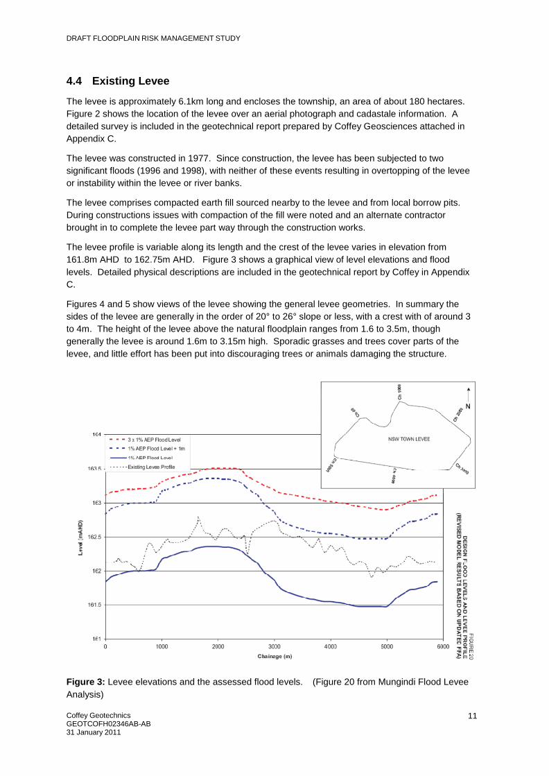
4.4 Existing Levee
The levee is approximately 6.1km long and encloses the township, an area of about 180 hectares.
Figure 2 shows the location of the levee over an aerial photograph and cadastale information. A
detailed survey is included in the geotechnical report prepared by Coffey Geosciences attached in
Appendix C.
The levee was constructed in 1977. Since construction, the levee has been subjected to two
significant floods (1996 and 1998), with neither of these events resulting in overtopping of the levee
or instability within the levee or river banks.
The levee comprises compacted earth fill sourced nearby to the levee and from local borrow pits.
During constructions issues with compaction of the fill were noted and an alternate contractor
brought in to complete the levee part way through the construction works.
The levee profile is variable along its length and the crest of the levee varies in elevation from
161.8m AHD to 162.75m AHD. Figure 3 shows a graphical view of level elevations and flood
levels. Detailed physical descriptions are included in the geotechnical report by Coffey in Appendix
C.
Figures 4 and 5 show views of the levee showing the general levee geometries. In summary the
sides of the levee are generally in the order of 20° to 26° slope or less, with a crest with of around 3
to 4m. The height of the levee above the natural floodplain ranges from 1.6 to 3.5m, though
generally the levee is around 1.6m to 3.15m high. Sporadic grasses and trees cover parts of the
levee, and little effort has been put into discouraging trees or animals damaging the structure.
Figure 3: Levee elevations and the assessed flood levels. (Figure 20 from Mungindi Flood Levee
Analysis)

DRAFT FLOODPLAIN RISK MANAGEMENT STUDY
Coffey Geotechnics GEOTCOFH02346AB-AB 31 January 2011
12
Figure 4: Levee View at riverbank.
Figure 5: Levee View along crest of levee.

DRAFT FLOODPLAIN RISK MANAGEMENT STUDY
Coffey Geotechnics GEOTCOFH02346AB-AB 31 January 2011
13
4.4.1 Geotechnical Assessment
Coffey conducted a geotechnical investigation and assessment of the existing flood levee at
Mungindi NSW. The geotechnical assessment is included in Appendix A.
In summary the geotechnical assessment found:
The current levee is formed from compacted earth fill, generally silty clays with varying degrees of
sand fraction. The clays are generally medium to high plasticity with liquid limits varying from 35% to
55%. The maximum dry density of the soil materials assessed was relatively uniform at around
1.72t/m3, with an optimum moisture content of about 18%. When compacted the soils were
assessed to have a low permeability, making them suitable for levee formation.
The soils were also assessed to be dispersive and are therefore susceptible to erosion, and their
high plasticity assessed to likely lead to shrinkage cracking during dry periods and swelling during
wet periods.
Groundwater was not encountered in any of the test pits excavated in the levee embankments, nor
was it expected.
4.4.2 Erosion and current state of the levee.
The levee (at the time of the geotechnical assessment in 2005) was observed to be in a satisfactory
condition, though erosion of parts of the levee had occurred, primarily at the crest and side slope of
parts of the levee. The eroded sections of the levee have been repaired and re raised with filling.
Rilling (to around 50mm deep) was observed over most of the levee. Some piping failure was also
observed.
Coffey (2005) recommended that a contingency plan be prepared in which stockpiles of sandbags
and rockfill be placed into areas of erosion or suspected instability, should a flood event be
predicted.
Sparse vegetation including mature trees have developed on the levee, particularly near the
riverbank. Animal burrows were also observed in 2005 some locations.
The levee is physically constrained on the western and north western extent by the river and private
property whilst the southern side, eastern and north eastern side of the levee are constrained only
by property boundaries and the proximity of the roadways.
Some sections of the levee are located close to the river bank edge and erosion of the riverbank as
the river develops will have impacts on the levee stability in the long term. Furthermore, scour could
occur depending on the actual water velocities experienced during flooding events.
If the levee were to be raised or additional load added to form erosion protection stability
assessment of the riverbank profiles would be required to assess the potential effects of proposed
works on stability.
Coffey (2005) assessed the stability of the existing levee. The results of the assessment indicated
that the Factor of Safety under three scenarios was generally in accordance with civil engineering
structures, though should scour of the riverbank occur the stability of the levee may be
compromised.

DRAFT FLOODPLAIN RISK MANAGEMENT STUDY
Coffey Geotechnics GEOTCOFH02346AB-AB 31 January 2011
14
Figure 6: Example piping in levee crest.
Figure 7: Example of riling in levee crest.

DRAFT FLOODPLAIN RISK MANAGEMENT STUDY
Coffey Geotechnics GEOTCOFH02346AB-AB 31 January 2011
15
4.4.3 Internal Drainage
The levee lacks internal drainage other than by drain points (flood gates) with poorly maintained
backflow valves. In 2005 the valves appeared to be inoperable.
No pumping system is incorporated to allow pump out of internal rainfall once the river floods and
the levee is put into use.
4.5 Community Consultation
4.5.1 Consultation process
In late 2004, Coffey undertook a resident survey to obtain community feedback on flooding issues in
the township.
The process included:
• Resident surveys
• Site meetings
• Follow up phone calls
• Incorporation of the feedback and results of consultation into this study.
The SES and Council were also consulted in on site meetings regarding the flooding issues in
Mungindi.
4.5.2 Results of the consultation
Resident Surveys were developed by Coffey and Constructive Solutions and distributed by Council.
A copy of the survey is included in Appendix D.
Three of the returned surveys were particularly helpful in understanding flooding issues. Each of the
three residents who completed these detailed responses were invited to meet in December 2005 to
provide more detailed feedback on flooding problems.
On 14th
December 2005, Mark Gibson and Stephen Parrish from MRG Water Consulting Pty Ltd
travelled to Mungindi and Moree to undertake consultation regarding flooding issues for Mungindi.
The first meeting was held at the State Emergency Service (SES) building in Mungindi at 3pm on
14th
December 2005. Those in attendance were:
• Fred Barlow (local councillor);
• Tony Clark (SES);
• Andy Doyle (long term resident);
• Mark Gibson (MRG);
• Stephen Parrish (MRG); and
• Jeff Fing (Works Superintendant - Moree Plains Shire Council).
At this meeting the following issues were discussed in detail:
• The impacts of flooding. Residents mentioned that in 1998 they were cut off from Moree for 5-6 weeks. A bridge between the two towns was cut and supplies had to be ferried in.
• Historical flooding, levee construction and flood gate operation.

DRAFT FLOODPLAIN RISK MANAGEMENT STUDY
Coffey Geotechnics GEOTCOFH02346AB-AB 31 January 2011
16
• Issues during flooding relating to medical services. For example there are often bureaucratic
issues between doctors, ambulances and doctors as they are located on different sides of the border.
• Flood preparation. Specifically regarding the SES, police and fire brigade.
• Local stormwater problems. A detailed discussion was held on the depth of water that occurs during local storm events. Residents mentioned that this was concerning them, and that some of the internal drainage outlets actually sloped uphill and only work when under pressure.
• Social impacts of flooding. Residents mention that during the 5-6 weeks of isolation that many
people were out of work, producing stress on marriages, stress to get back working on the land and pressure to get their children to school rather than be stuck with children in their houses for six weeks at a time.
• Economic impacts of flooding. As well as residents being unable to work, the flooding reduced residents use of pubs, clubs and restaurants, placing pressure on these businesses. Shops ran short of supplies and were also affected.
• Growth rates in the township.
• Effects of levee overtopping. Residents outlined the massive implications for a flood event that
overtopped the levee. Essentially every house in town would be inundated above habitable floor level.
• Aspects of the township of historic or cultural significance. Very little was obtained from this discussion.
• All participants agreed with a request to install a new flood gauge on the McIntyre River system
approximately 20kms upstream of Mungindi, immediately upstream of where the Darling River connects, (close to an existing weir). This would allow better flood warning and preparation for the town.
Following the meeting, Jeff Fing from Moree Plains Shire Council drove the representatives from
MRG around the levee and inspected the flood gates.
The second meeting was held at the Moree Plains Shire Council office in Moree at 9:30 am on 15th
December 2005. Those in attendance were:
• Mark Gibson (MRG);
• Stephen Parrish (MRG);
• Bruce unknown surname, (Planning Officer – Moree Plains Shire Council) and
• Anne-Maree Newberry (Manager of Planning - Moree Plains Shire Council).
At this meeting the following issues were discussed in detail:
• Planning levels for new dwellings. The site visit observed that many of the houses in Mungindi are lowset or slab on ground.
• Warning and isolation times for residents. Also the impacts of major flooding above the top of the levee.
• Township zoning, population growth projections and Aboriginal Land Council involvement. An updated social plan was reported to be being developed by MPSC.
• Historical sites. Anne-Maree identified the “One Tonne Post” as a historical site of state significance and the railway station masters home as local significance.
• Endangered species in the area. It was reported that one specific species was at risk in the Mungindi area. This species was Sminthopsis macroura or the Stripe-faced Dunnart. It’s conservation status in NSW is listed as vulnerable. They inhabit dry grasslands and shrublands,

DRAFT FLOODPLAIN RISK MANAGEMENT STUDY
Coffey Geotechnics GEOTCOFH02346AB-AB 31 January 2011
17
often along drainage lines and shelter in cracks in the soil, grass tussocks or under rocks and logs during periods of hot weather.
The third meeting was held at the Moree Plains Shire Council office in Moree at 1 pm on 15th
December 2005. Those in attendance were:
• Mark Gibson (MRG);
• Stephen Parrish (MRG); and
• Simon Heung (Design Manager - Moree Plains Shire Council).
At this meeting the following issues were discussed in detail:
• Impacts and contingencies planning for a flood event that overtopped the levee
• Levee gates and levee wall needing repairs.
• Local stormwater ponding issues.
An audio recording of each of the meetings was taken and is currently held by MRG Water
Consulting Pty Ltd.
4.5.2.1 Summary of community consultations to be addressed in flood management planning
The responses from the community, Council and emergency services have been incorporated into
the floodplain management options presented in this report.
In summary there was:
• General support for planning for contingencies for an overtopping flood event.
• Strong value placed on the existing levee.
• Strong support for raising and upgrading the levee, and upgrading and maintaining flood gates, due to the economic and social impacts flooding.
• Strong support for installation of an additional flood gauge upstream to provide greater warning of a flood event.
• A perception that planning controls on development were less desirable than flood proofing the town by raising the levee.
• Little desire to modify existing residences for flooding when the levee only needs a little additional material to reduce the chance of overtopping.
• Little expectation or desire to expand the levee to include other facilities in the town.
• A recognition of the need for better preparedness by residents and an acknowledgment that more information could be provided to residents by Council and the SES to make flood events less of a surprise and to improve the authorities responses to flooding.
These concepts have been incorporated into this report by use of the values of the community and
stakeholders in the matrix assessment, and through development of some of the suggested
responses into options for risk management of Mungindi in this study.
4.6 Flood readiness
Mungindi has a long history of flooding. The consultation process revealed residents of Mungindi are
aware of the flood liable nature of their land and residences. The community memory includes the
history of flooding and generally residents are well prepared for flooding. The existing levee and
relatively slow onset of flooding historically has allowed people to prepare prior to the town being cut
off. As a consequence, the general population is relatively well prepared for most flood events.

DRAFT FLOODPLAIN RISK MANAGEMENT STUDY
Coffey Geotechnics GEOTCOFH02346AB-AB 31 January 2011
18
As flood events can be long duration (several weeks) assistance with re supply of the township and
isolated residents is required.
Currently there are no specific flood warning systems, other than those managed by the Bureau of
Meteorology. This is likely due to the slow nature of flood advances from upstream.
The lack of internal drainage in the levee area is concerning, however this issue has not proven to be
a problem in the past. We note however that should a significant rainfall event occur during a
flooding event where the levee is not overtopped, the consequences would be significant. Based on
the comments received during the consultation undertaken in 2005 we understand that if such a
confluence of events were to occur, then large mobile pumps would be transported in via boat or
helicopter and the township kept dry.
Consultations with the SES indicates that preparation of a Mungindi specific Floodsafe Guide could
be of significant value to flood readiness. An example of a Floodsafe guide is included in Appendix
E.
4.7 Economic Impacts of Flooding
Detailed survey of the township indicates ground levels inside the levee that vary from 160.0 m to
160.8 m AHD. If the levee overtops and fills it could be expected that flood depths within the levee
may reach up to 1.72 m, with an average depth of 1.2 m. However, the river wraps itself around the
township and flood levels vary along the levee by up to a meter. Therefore the extent and depth of
inundation of the township if the levee was overtopped is uncertain, (it depends on where the levee
was breached).
Looking at the impacts of historical flood events gives an indication of the extent of inundation. In
1976, Mungindi experienced the second highest flood event on record. At this time the town only had
a small levee, which was overtopped. It was reported that 24 occupied buildings within the town
levee were inundated and sections of the town remained flooded for 11 days. Resident surveys
indicate that not all of these buildings were flooded above floor level. The 1976 event was estimated
to be 5% AEP in magnitude by recent flood studies, and the flood height was substantially less than
the current levee crest elevation.
There has been some growth in the township since 1976 with the township now comprising
approximately 280 houses. During the same timeframe the levee has also been increased in height.
It is expected that over the next ten years the population growth within Mungindi will either be
stagnant or negative growth. There is some difficulty with the exact number of people living in
Mungindi as there is an indigenous population which is very transient and have not participated in
the regular census. However it is feasible that the majority of the 280 houses would be flooded
above floor level if the existing levee was overtopped by flooding, as a large percentage of the
houses surveyed by Council in a recent ad hoc survey indicates that a large percentage of homes in
Mungindi have floor levels below the level of the existing levee.
Usually flooding of a house does not destroy the structure but does destroy it’s fittings, furniture,
appliances, appearance and personal effects. Internal wall cladding and finishes are particularly
affected. Direct damages a house have been estimated at $19894.70 per property, as per
calculations set out in Appendix B. If we assume this as an average damage bill per property, then a
flood which only just overtopped the levee and inundated 250 houses above floor level would cost a
total tangible damage bill to properties inside the levee of $4.9 million.

DRAFT FLOODPLAIN RISK MANAGEMENT STUDY
Coffey Geotechnics GEOTCOFH02346AB-AB 31 January 2011
19
It is difficult, if not impossible, to quantify intangible damages in financial terms. Intangible damages
are real and represent a significant cost to flood affected persons, a cost that can endure for many
years. Most floodplain risk management studies acknowledge intangible damages but do not
attempt to quantify them.
In April/May 1975, some 15 months after the 1974 Brisbane flood, a follow-up survey of flood victims
found that about 25% still had not recovered from the emotional trauma of the event. Factors that
contributed to non-recovery included the severity of flooding, the degree of the resulting financial
hardship, age and socio-economic status. Elderly people on low incomes whose houses were
deeply flooded were the most ill affected. Literature searches have revealed that the stresses and financial difficulties caused by the flooding
have lead to marriage breakdowns, depressions and even suicides. However there currently is no
detailed information of deaths in the Mungindi area but this intangible flood effect does occur.
4.8 Social and Health Impacts of Flooding
There has not been any published information on the social effects of flooding in Mungindi, however
some of the relevant points will be summarised here. Flood events, which occur regularly in
Mungindi, are a very isolating event. The township of Mungindi, which is surrounded by a levy, is
often isolated for up to five to six weeks. In addition to the township, the homesteads of the farmers
close to Mungindi will also be isolated just as long.
During a large flood event, the telephone landlines and fax lines do not work. Mobile phones will
work in the Mungindi township area during a flood but for farming families living outside Mungindi,
the only type of communication is via satellite phone. Recently some farmers have purchased
satellite internet connections for their homes, which will assist during a flood event, but most of them
at this stage don’t have satellite phones.
The children who live in those homesteads which have a satellite internet connection can receive
and complete their school work over the internet but not all families have this. The impact of having
children at home and not being able to go to school or even outside the family home puts added
pressure on parents who are not able to do their regular work.
The prolonged isolation also has an impact on food and drinking water supplies. Most farming
families capture rainwater in tanks and as long as these supplies of water remain free from
floodwater they will last until the floodwaters recede. Although some families do store food, there is
often a need for fresh food (milk etc) to be provided to these isolated families during a flood event.
In addition to isolation, during flood events there is an increase in the number of snakebite casualties
in the area. This has caused difficulties in the past, as there are no medical helicopters in close
proximity to Mungindi. The nearest is Tamworth, Newcastle or Toowoomba as there are no Medivac
helicopters in Goondiwindi. The SES has access to a helicopter which it uses to deliver emergency
aid.
The state border has also caused bureaucratic issues because the hospital is located on the
Queensland side of the border and the NSW township is on the southern or New South Wales side
of the border. However these bureaucratic issues are generally ignored during times of crisis and
flooding. However, the community consultation process did note that minor bureaucratic issues
around insurances and areas or responsibility can sometimes hamper service delivery, and that
some issues in the past have left some residents cautious about relying on cross border assistance.

DRAFT FLOODPLAIN RISK MANAGEMENT STUDY
Coffey Geotechnics GEOTCOFH02346AB-AB 31 January 2011
20
4.9 Impact of Rural levees
Webb, McKeown and Associates Pty Ltd, (2009) assessed the impact of the rural levee located in
the immediate vicinity of the township. Specifically it stated the following about rural levees,
Limited survey data was available to accurately define the levels of the rural levees. An aerial
photograph of the 1996 flood was assessed to identify those rural levees which prevented significant
flow to areas behind the levees. These areas were then removed from the flood model. In the
absence of more detailed survey data, these areas were also removed for the design events. This is
a relatively conservative arrangement since in larger flood events (eg. 1% AEP or greater) it is
possible that some of the rural levees may be overtopped and the areas behind the levees provide
conveyance for flows…The model results indicate that the rural levees in the vicinity of the town
have a significant effect on increasing flood levels at the town.
The report concluded that the rural levees raised flood levels at the flood gauge by between 0.22 m
and 0.57 m. The results are considered as indicative only. More detailed survey of the rural levees
is required before an accurate assessment of the impact of the rural levees for the 1% AEP event
could be undertaken. It is recommended that this additional survey and flood modelling be
undertaken as this has a significant effect on flood levels in the area and impacts on the results of
this risk management plan.
5 FLOODPLAIN MANAGEMENT OPTIONS
This floodplain risk management study identifies an integrated mix of measures and options to
manage the three specific types of flood risks for Mungindi. These risks are:
1. Existing Flood Risk: Measures to manage flood damage and personal danger to the existing community and properties to an acceptable level;
2. Future Flood Risk: Measures to manage flood damage and personal danger for future development to an acceptable level; and
3. Continuing Flood Risk: Measures to manage the personal danger associated with the existing and proposed future management measures being overwhelmed by a larger flood event and in areas not protected by the Mungindi levee.
While evaluating these measures it is important to keep in mind that the highest flood levels that
have occurred during the residents of Mungindi’s lifetime was in 1976, where the flood level
recorded was 160.95 m AHD at the town gauge.
The 1% AEP design flood level, (the recommended flood planning level), which has been calculated
by Webb, McKeown and Associates Pty Ltd, (2009) is 161.72 m AHD at the town gauge.
5.1 Options to Manage Existing Flood Risk
The following options have been considered to manage the existing flood risk:
1. Maintain the existing flood protection measures, and
2. Raising the existing levee to 1% AEP plus 1 m.
3. House raising beyond the height of the existing levee.
4. Voluntary Purchase of Homes.
The following sections discuss each option.

DRAFT FLOODPLAIN RISK MANAGEMENT STUDY
Coffey Geotechnics GEOTCOFH02346AB-AB 31 January 2011
21
5.1.1 Maintain Existing Flood Protection Measures.
Coffey (2005) reported that there was evidence of minor riling of the levee embankment over the
majority of the levee but no significant erosion has occurred to date. Thus the levee is expected to
provide significant protection, even if no additional maintenance is undertaken.
Mungindi has two flood gates, which allow water to be drained through the levee. These floodgates
are kept open during the majority of the year and are closed with the onset of a large flood. A site
inspection showed that the gates were not in good working order and repairs need to be carried out
in the near future. It is possible that if a large flood event occurred soon that they would fail and the
town could become inundated from water entering through the gates. Thus it is very important that
the gates be repaired and maintained as part of MPSC maintenance works.
This option is essentially a “do nothing option”, that is the levee will be retained at its current height
and the gates will be maintained so they allow the levee to perform its current function.
The option does not create any additional environmental, economic or social impacts. There are no
additional benefits to the community from this option.
5.1.2 Raising the Existing Levee to 1% AEP plus 1 m.
The existing levee is the major flood mitigation measure for the township. The existing levee has a
crest which is only marginally higher than the 1% AEP event. At its lowest point it is 0.25 m higher
than the 1% AEP event flood level and at its highest it is 1.1 m above the 1% AEP event flood level.
Generally speaking the levee does not have a 1m freeboard that is generally recommended by NSW
DECCW. Raising the levee to ensure that it has 1 m freeboard above the 1% AEP flood event will
reduce the existing flood risk.
5.1.2.1 Possible configuration of a raised levee.
Raising of the levee by increasing the height of the existing levee has been considered as a logical
option. Conceptually the levee would expand laterally and vertically as shown in Sketch 1 below.
Loads from earth fill may affect the riverbank stability and could limit the use of earth fill for
expanding the levee near the river. Where this is the case extension of the river height by use of
concrete walls may be considered. Sketch 2 provides a graphical example.
The current levee does not include a spillway. Spillways are used to allow controlled water ingress
into a levee where the levee will be overtopped. Spillways can minimise damage to infrastructure
within the levee and the levee itself, as well as raise community awareness to the concept that
levees will not protect it from all events. The Floodplain Risk Management Guideline No 14
Spillways for Urban Levees prepared by the NSW department of Natural Resources provides
comment on their use in design of levee systems.
Spillways are normally located remote from infrastructure, and in locations where flood flows are
limited or reduced to reduce the potential for levee damage during overtopping. In Mungindi
possible locations for a spillway could include the areas south and downstream of the NSW
township, around Ch4700 to Ch5000. In this area flood velocities are expected to be relatively low
and little infrastructure is located nearby.

DRAFT FLOODPLAIN RISK MANAGEMENT STUDY
Coffey Geotechnics GEOTCOFH02346AB-AB 31 January 2011
22
Possible raised levee profile
(height varies as the existing
levee height varies)
Existing Levee
Sketch 1: Possible earth fill levee raising configuration.
Possible raised levee using concrete wall
(height varies as the existing levee height
varies)
Existing Levee
Sketch 2: Possible concrete wall levee raising configuration.
5.1.2.2 Land Acquisition Issues
There is some uncertainty about whose land the levee is built upon. It seems that when the levee
was originally constructed it was done without purchasing or obtaining an easement over the land
upon which it falls. If the levee was to be raised, it would be appropriate and necessary to purchase
the land or obtain an easement over the land upon which the levee will sit. The costs of purchase or
obtaining an easement over approximately 12 hectares of land on many titles is not known, and is
difficult to calculate without a detailed study, but we have assumed a budget figure of say $300,000.
The actual costs will be highly dependent on the number of titles affected and the legal costs for
readjustment or placing easements over those titles.
5.1.2.3 Detailed Design
Detailed design and analysis of any levee raising scheme will be required. The design will need to
consider:
1. Levee land ownership constraints.
DRAFT FLOODPLAIN RISK MANAGEMENT STUDY
Coffey Geotechnics GEOTCOFH02346AB-AB 31 January 2011
23
2. Stability along the riverbank, and further geotechnical analysis of the proposed structures, likely using the existing Coffey Geosciences models as a starting point.
3. The need and location of potential spillways to allow controlled overtopping.
4. Detailed spillway design, including potential water flows and effects on the levee, residents and assets when the levee overtops.
5. The need for surge areas and detention basins.
6. Internal drainage mechanisms and operational issues, including design and maintenance of pumps and flood gates as appropriate.
7. Consider the environmental impacts of raising the levee in detail, in particular the issues near the river.
5.1.2.4 Estimated Construction Costs
We estimate that the amount of fill needed to raise the levee to the 1% AEP + 1 m is approximately
65,000 m3. An estimate of costs was compiled by Coffey after discussion with Paul Wilde (Wilde
Civil Pty Ltd) in February 2010. Wilde Civil Pty Ltd was the contractor who completed the original
levee.
Based on unit rates and estimates of work to be undertaken earthwork costs are estimated at
$525,000. Foundation preparation and compaction of the foundation to improve the existing levee
quality requires an additional cost of $280,000.
This estimate does not allow for the use of concrete walls to extend the levee as the length of walls
is likely to be small, and the reduced filling needed and reduced foundation preparation costs are
likely to offset the concrete wall construction costs.
5.1.2.5 Cost/Benefit of Raising the Levee
Including planning, approvals, design and 20% contingencies, the total cost is estimated at $1.3
million. Appendix A of this report provides a breakdown of this estimate.
If a flood occurred that peaked at this level, without the upgraded levee it is estimated that
approximately 250 buildings would be flooded to around 1.5m above floor level. The tangible
damages for this would be approximately $6.6 million.
The cost to raise the levee is less than 25% of the possible tangible damages that could occur in the
event that the township was flooded above the current levee. It will also significantly reduce the risk
of personal loss, danger, stress and trauma and therefore has a large number of social benefits.
The measure is not expected to have any major environmental impacts. Raising the levee increases
the area of the levee footprint by an average of 6.3 m2/m, which equates to around 3 hectares of
land in total. This will generally have minimal effects on the surround environment except near the
river where some significant gum trees exist. This would need to be examined further during the
detailed design phase.
5.1.3 House Raising Beyond the Height of the Existing Levee.
Another option is to raise the habitable floor level of houses within the levee above the height of the
levee. However, not all houses are suitable to raise. Many of the houses in Mungindi are of slab on
ground construction are generally either impossible or too expensive to raise. Houses best suited to
raising are timber framed and clad with non-masonry materials. It has been estimated that 60% of

DRAFT FLOODPLAIN RISK MANAGEMENT STUDY
Coffey Geotechnics GEOTCOFH02346AB-AB 31 January 2011
24
the 250 houses in Mungindi may be suitable to be raised. Most houses would require raising by
approximately 2.5 m.
The costs to raise a house in Mungindi has been sourced from the report titled Review of Mitigation
Costs for Bogabilla Floodplain Risk Management Strategy by Constructive Solutions, July 2009.
Bogabilla is a remote town, similar to Mungindi. The cost to raise a house by 1.2 m was estimated
to be $55 000. It is estimated that raising a house by 2.5 m does not increase costs significantly and
the cost for this has been estimated at $60,000.
The cost to raise 150 houses is $9 million. The tangible benefit for the household is $19894.70 as
per Section 3.2 per household, a total of $2.9 million. Thus the costs to raise the houses are
approximately $6.9 million higher than the benefits.
5.1.4 Voluntary Purchase of Homes.
This measure allows homes at risk of flooding to be purchased from residents on a voluntary basis.
The social and economic impacts of this option are severe. Essentially this option could lead to the
town being unsustainable due to a serious decline in the town’s population.
The cost of purchasing a home in Mungindi ranges from $40 000 to $120 00. The tangible benefit
for the household is $19894.70 as per Section 3.2 per household totaling $5 million.
Assuming only 60 houses were purchased the cost would be in the order of $7.2 million, though the
actual costs would depend on the timeline for residents offering houses up for sale. This estimated
cost is approximately $5.9 million greater than the cost of raising the levee and would only benefit
the people who left the town. The costs of this option would outweigh the benefits for many homes
purchased.
Because of this and the social and economic impacts on the town, this option is not recommended.
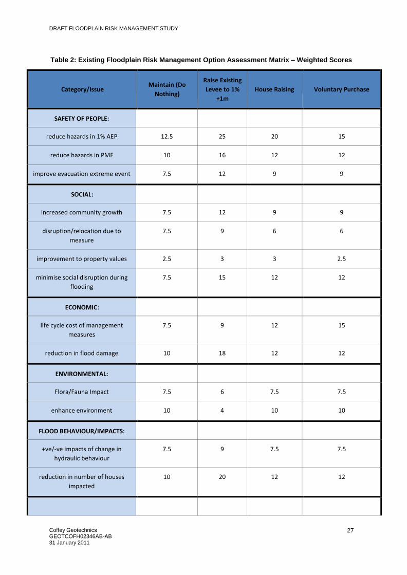
5.1.5 Assessment of Proposed Existing Flood Risk Management Measures.
A multi-criteria analysis has been undertaken as per NSW Floodplain Development Manual, (April
2005) to compare proposed options and weigh their relative merits, as shown in Table 1 and 2. The
totals in Table 2 show the higher priority options. All are scored better than the ‘Do Nothing’ option.
Notes on Tables 1 and 2 - The weighting are from 1 to 5, with 5 the highest rating. These have been
derived from Council, committee and community consultations and discussions. The options have
been rated on a scale of 1 to 5, with 5 the highest rating. The Do Nothing option is weighted at 2.5
for each issue as it does not have a cost or benefit to the community. This provides a basis for
ranking other options based upon their relative benefit or cost. Options with positive benefits are
scored from >2.5 to 5. Options with negative impacts are scored from 0 to < 2.5. Scores have also
been derived from council, committee and community consultations and discussions
Table 2 shows that the floodplain risk management option which has the highest weighted score is
that of raising the levee to 1% AEP + 1 m. This option is recommended to be adopted by MPSC and
the FPL to reduce the existing flood risk.
The option to undertake houses raising or voluntary purchase is not recommended as the costs
almost outweigh the benefits and there are substantial social and economic impacts from voluntary
purchasing.

DRAFT FLOODPLAIN RISK MANAGEMENT STUDY
Coffey Geotechnics GEOTCOFH02346AB-AB 31 January 2011
25
Table 1: Existing Floodplain Risk Management Option Assessment Matrix – Raw Scores
Category/Issue
Weighting 5
highest, 1
lowest
Maintain
(Do
Nothing)
Raise Existing
Levee to 1%
+1m
House
Raising
Voluntary Purchase
SAFETY OF PEOPLE:
reduce hazards in 1% AEP
5
2.5
5
4
3
reduce hazards in PMF
4
2.5
4
3
3
improve evacuation extreme event
3
2.5
4
3
3
SOCIAL:
increased community growth
3
2.5
4
3
3
disruption/relocation due to
measure
3
2.5
3
2
2
improvement to property values
1
2.5
3
3
2.5
minimise social disruption during
flooding
3
2.5
5
4
4
ECONOMIC:
life cycle cost of management
measures
3
2.5
3
4
5
reduction in flood damage
4
2.5
4.5
3
3
ENVIRONMENTAL:
Flora/Fauna Impact
3
2.5
2
2.5
2.5
enhance environment
4
2.5
1
2.5
2.5
FLOOD BEHAVIOUR/IMPACTS:
+ve/‐ve impacts of change in
hydraulic behaviour
3
2.5
3
2.5
2.5
reduction in number of houses
impacted
4
2.5
5
3
3

DRAFT FLOODPLAIN RISK MANAGEMENT STUDY
Coffey Geotechnics GEOTCOFH02346AB-AB 31 January 2011
26
Category/Issue
Weighting 5
highest, 1
lowest
Maintain
(Do
Nothing)
Raise Existing
Levee to 1%
+1m
House
Raising
Voluntary Purchase
FEASIBILITY:
physical/technical
4
2.5
4
4
5
financial Council
3
2.5
2
3
3
potential for State/Federal funding
2
2.5
4
4
4
COMPATIBILITY:
other hazards & urban drainage
3
2.5
2.5
2.5
2.5
environmental management
measures
3
2.5
2
2.5
2.5
CRITICAL INFRASTRUCTURE:
improve availability & function
3
2.5
4
2.5
2.5
DRAFT FLOODPLAIN RISK MANAGEMENT STUDY
Coffey Geotechnics GEOTCOFH02346AB-AB 31 January 2011
27
Table 2: Existing Floodplain Risk Management Option Assessment Matrix – Weighted Scores
Category/Issue
Maintain (Do
Nothing)
Raise Existing
Levee to 1%
+1m
House Raising
Voluntary Purchase
SAFETY OF PEOPLE:
reduce hazards in 1% AEP
12.5
25
20
15
reduce hazards in PMF
10
16
12
12
improve evacuation extreme event
7.5
12
9
9
SOCIAL:
increased community growth
7.5
12
9
9
disruption/relocation due to
measure
7.5
9
6
6
improvement to property values
2.5
3
3
2.5
minimise social disruption during
flooding
7.5
15
12
12
ECONOMIC:
life cycle cost of management
measures
7.5
9
12
15
reduction in flood damage
10
18
12
12
ENVIRONMENTAL:
Flora/Fauna Impact
7.5
6
7.5
7.5
enhance environment
10
4
10
10
FLOOD BEHAVIOUR/IMPACTS:
+ve/‐ve impacts of change in
hydraulic behaviour
7.5
9
7.5
7.5
reduction in number of houses
impacted
10
20
12
12

Coffey Geotechnics GEOTCOFH02346AB-AB 31 January 2011
28
DRAFT FLOODPLAIN RISK MANAGEMENT STUDY
Category/Issue
Maintain (Do
Nothing)
Raise Existing
Levee to 1%
+1m
House Raising
Voluntary Purchase
FEASIBILITY:
physical/technical
10
16
16
20
financial Council
7.5
6
9
9
potential for State/Federal funding
5
8
8
8
COMPATIBILITY:
other hazards & urban drainage
7.5
7.5
7.5
7.5
environmental management
measures
7.5
6
7.5
7.5
CRITICAL INFRASTRUCTURE:
improve availability & function
7.5
12
7.5
7.5
TOTAL
152.5
213.5
187.5
189

DRAFT FLOODPLAIN RISK MANAGEMENT STUDY
Coffey Geotechnics GEOTCOFH02346AB-AB 31 January 2011
29
5.2 Options to Manage Future Flood Risk The following options have been considered to manage the future flood risk:
5.2.1 Development Controls on New Building Floor Levels.
An option is to have all new buildings within the levee system comply with a minimum floor level. The
minimum floor level would be the 1% AEP flood level plus a 0.3m freeboard. This measure is not
expected to have a large impact as new buildings are only constructed infrequently but it will ensure
new dwellings do have higher flood immunity. The costs of implementation for Council are minor and
there are tangible benefits of up to $19894.70 per dwelling, with no environmental impacts. There is
also an intangible benefit of $12,500 per dwelling.
5.2.2 Development Controls on New Levees or filling outside the Township levee.
All proposed filling or new levees outside the township levee needs to be assessed using the existing
hydraulic model of the waterway, to ensure the works do not have a detrimental impact on upstream or
downstream flood levels. The Mungindi Levee Flood Analysis (2009) shows that the rural levees close
to the township do increase flood level by up to 0.57 m as discussed in Section 3.6. In addition to
assessing the filling on the applicants land, the applicant should assess the impact of the cumulative
effect of the remainder of the catchment undertaking similar filling works. The development controls
should extend both upstream and downstream of the township to a radius of 5 km. The benefits of this
option are not easily predicted but it will prevent flood levels being increased leading to flood damage.
5.2.3 Development Controls on New Residential Development outside the Township levee.
To ensure that the future flood risk does not increase, new development controls will ensure that all
future residential development will be located within the levee. Planning projections indicate that very
little development will occur in the near future. The costs of implementation of this control for Council
are minor and there are tangible benefits of up to $19894.70 per dwelling, with no environmental
impacts. There is also an intangible benefit of $12,500 per dwelling.
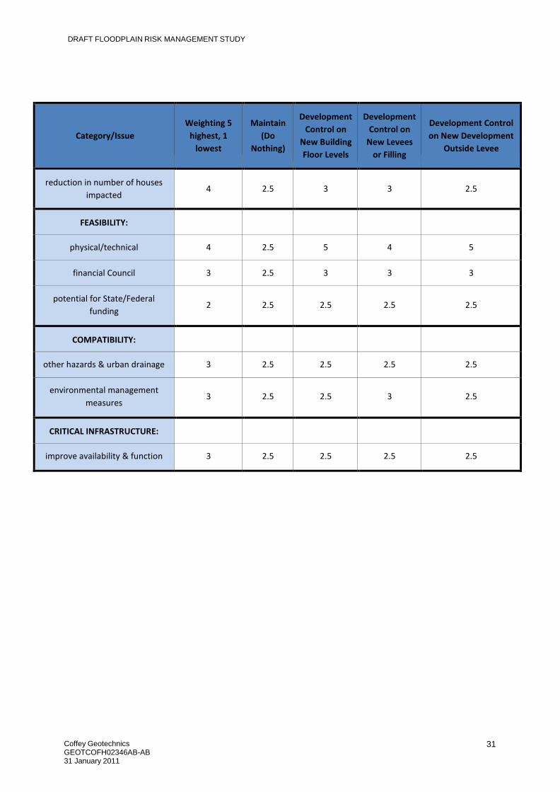
5.2.4 Assessment of Proposed Future Flood Risk Management Measures.
A multi-criteria analysis has been undertaken as discussed previously in Section 6 of this report.
It is recommended that all of the options proposed to manage future flood risk be adopted. The
recommended options, (in priority), are:
1. Development Controls on New Building Floor Levels.
2. Development Controls on New Levees or filling outside the Township levee.
3. Development Controls on New Residential Development outside the Township levee.

DRAFT FLOODPLAIN RISK MANAGEMENT STUDY
Coffey Geotechnics GEOTCOFH02346AB-AB 31 January 2011
30
Table 3: Future Floodplain Risk Management Option Assessment Matrix – Raw Scores
Category/Issue
Weighting 5
highest, 1
lowest
Maintain
(Do
Nothing)
Development
Control on
New Building
Floor Levels
Development
Control on
New Levees
or Filling
Development Control
on New Development
Outside Levee
SAFETY OF PEOPLE:
reduce hazards in 1% AEP
5
2.5
5
3
4
reduce hazards in PMF
4
2.5
3
3
3
improve evacuation extreme
event
3
2.5
2.5
2.5
2.5
SOCIAL:
increased community growth
3
2.5
2.5
2.5
2.5
disruption/relocation due to
measure
3
2.5
4
2.5
2.5
improvement to property values
1
2.5
4
2.5
3
minimise social disruption during
flooding
3
2.5
4
2.5
4
ECONOMIC:
life cycle cost of management
measures
3
2.5
2.5
2.5
2.5
reduction in flood damage
4
2.5
3
3
3
ENVIRONMENTAL:
Flora/Fauna Impact
3
2.5
2.5
3.5
2.5
enhance environment
4
2.5
2.5
2.5
2.5
FLOOD BEHAVIOUR/IMPACTS:
+ve/‐ve impacts of change in
hydraulic behaviour
3
2.5
2.5
5
2.5
DRAFT FLOODPLAIN RISK MANAGEMENT STUDY
Coffey Geotechnics GEOTCOFH02346AB-AB 31 January 2011
31
Category/Issue
Weighting 5
highest, 1
lowest
Maintain
(Do
Nothing)
Development
Control on
New Building
Floor Levels
Development
Control on
New Levees
or Filling
Development Control
on New Development
Outside Levee
reduction in number of houses
impacted
4
2.5
3
3
2.5
FEASIBILITY:
physical/technical
4
2.5
5
4
5
financial Council
3
2.5
3
3
3
potential for State/Federal
funding
2
2.5
2.5
2.5
2.5
COMPATIBILITY:
other hazards & urban drainage
3
2.5
2.5
2.5
2.5
environmental management
measures
3
2.5
2.5
3
2.5
CRITICAL INFRASTRUCTURE:
improve availability & function
3
2.5
2.5
2.5
2.5

DRAFT FLOODPLAIN RISK MANAGEMENT STUDY
Coffey Geotechnics GEOTCOFH02346AB-AB 31 January 2011
32
Table 4: Future Floodplain Risk Management Option Assessment Matrix – Weighted Scores
Category/Issue
Maintain (Do
Nothing)
Development
Control on
New Building
Floor Levels
Development
Control on New
Levees or Filling
Development Control on
New Development
Outside Levee
SAFETY OF PEOPLE:
reduce hazards in 1% AEP
12.5
25
15
20
reduce hazards in PMF
10
12
12
12
improve evacuation extreme event
7.5
7.5
7.5
7.5
SOCIAL:
increased community growth
7.5
7.5
7.5
7.5
disruption/relocation due to measure
7.5
12
7.5
7.5
improvement to property values
2.5
4
2.5
3
minimise social disruption during
flooding
7.5
12
7.5
12
ECONOMIC:
life cycle cost of management
measures
7.5
7.5
7.5
7.5
reduction in flood damage
10
12
12
12
ENVIRONMENTAL:
Flora/Fauna Impact
7.5
7.5
10.5
7.5
enhance environment
10
10
10
10
FLOOD BEHAVIOUR/IMPACTS:
+ve/‐ve impacts of change in hydraulic
behaviour
7.5
7.5
15
7.5
reduction in number of houses
impacted
10
12
12
10

DRAFT FLOODPLAIN RISK MANAGEMENT STUDY
Coffey Geotechnics GEOTCOFH02346AB-AB 31 January 2011
33
Category/Issue
Maintain (Do
Nothing)
Development
Control on
New Building
Floor Levels
Development
Control on New
Levees or Filling
Development Control on
New Development
Outside Levee
FEASIBILITY:
physical/technical
10
20
16
20
financial Council
7.5
9
9
9
potential for State/Federal funding
5
5
5
5
COMPATIBILITY:
other hazards & urban drainage
7.5
7.5
7.5
7.5
environmental management measures
7.5
7.5
9
7.5
CRITICAL INFRASTRUCTURE:
improve availability & function
7.5
7.5
7.5
7.5
TOTAL
152.5
193
180.5
180.5

DRAFT FLOODPLAIN RISK MANAGEMENT STUDY
Coffey Geotechnics GEOTCOFH02346AB-AB 31 January 2011
34
5.3 Options to Manage Continuing Flood Risk
The following options have been considered to manage the continuing flood risk:
5.3.1 Provide interpretive advice on gauge levels and anticipated flooding effects.
Community consultation indicated that there is some confusion as to what river levels mean in terms of
flood levels in the Mungindi township. Whilst there is a long lead time to flooding, there is little clear and
concise information as to what effects a certain river height might have.
We recommend that Council provide clear interpretive signs that show the level of the crest of the
levee, and reference this to river heights at the Mungindi Gauge and the gauge immediately upstream
of Mungindi. This would allow clear interpretation of the effects of the rising river and reinforce to
residents that the levee is only one layer of flood preparedness.
Interpretive signs would be located at prominent public places such as the post office and shops, and
other locations in the town.
The cost for this would be relatively low, estimated to be around $15,000. The benefits include
increased safety and warning times and reduced losses due increased preparation, although it is
difficult to quantify, (perhaps > $100,000).
5.3.2 Improve Community Flood Preparation and Post Event Response.
Community flood preparation and post event response could be enhanced by the community preparing
for flooding in the following ways:
1. The community should plan to gather together each November to review emergency preparations, update details, plan emergency responses and educate the community on flood plain risk management measures. Moree Plains Shire Council officers should take the initiative in planning and promoting this evening, while a flood specialist can be commissioned to prepare materials and conduct the evening. (Cost $10,000)
2. Education of the community at the regular community meetings and at other times will increase the flood readiness of the community. The Council should not rely on the next major flood to re-educate the community. Residents need to understand that floods are likely to interfere with normal activities in the floodplain. The importance of education cannot be overstressed. The following simple education strategies could be used:
a) Reminding the local residents of the flooding issue from time to time in local newspapers and at community meetings;
b) Displays of flood photographs and newspaper articles at the post office and local shops in Mungindi and Moree;
c) Disseminating flood information leaflets about flooding (see SES Examples in Appendix D);
d) Preparation of a video of historic floods in the area, (could be shown at community meeting);
e) Erecting signs on street that show flood levels of previous significant flood events;
f) School projects on floods and flood management; and
g) Commemorations of major flood events that have occurred in the past.

DRAFT FLOODPLAIN RISK MANAGEMENT STUDY
Coffey Geotechnics GEOTCOFH02346AB-AB 31 January 2011
35
(Cost approx $25,000)
3. The residents of Mungindi and the flood plain management committee have indicated that they require a better system of disseminating flood information needs to be established. For example, within the township flood information could be posted at the post office. It would also be appropriate to set up a system where updated information was posted on the website and texted to all families in the area. (Cost approx $15,000)
4. If the levee is overtopped, evacuation of some residents from their homes may be required. A plan should be prepared which will allow evacuation of families from low lying homes before the levee overtops. Survey of each house floor level will be required to prepare and prioritise this plan, and each home owner should be notified as to the level of their home in comparison to the crest of the levee. The SES should guide the preparation and dissemination of this plan, even if its preparation is commissioned by the Council. The SES should prepare an emergency gathering point within the town which would allow residents to be safe from flood waters until evacuation could occur in case an extreme event such as a PMF occur and the town levees are overtopped and destroyed. (Cost approx $25,000)
5. The Council should compile and update each year a list of people with specialist skills, (such as medical, able to operate heavy machinery), buildings that could be used to shelter evacuees and other resources such as tractors, boats, radio operators, pilots, electricians, engineers etc to be called upon if required. (Costs approx $5,000)
6. Each family could prepare their properties for the occurrence of a flood event by ensuring valuables can be stored away above the FPL or higher. They could review family emergency procedures and replace/charge batteries in torches and radios and refresh long term supplies each year in November. The cost per family is estimated to be approximately $1000. Many of the benefits are intangible but savings from damage to property could top $10,000.
The benefits include increased safety and reduced tangible and intangible damages,
although these are hard to quantify, (> $100,000).
5.3.3 Assessment of Proposed Continuing Flood Risk Management Measures.
A multi-criteria analysis has not been undertaken to assess the measures to mitigate the continuing
flood risk. This is because many of the measures provide intangible benefits that cannot be accurately
measured.
The options recommended are low cost and provide clear benefits to the community in the longer term.
We recommend Council adopt both options, and immediately begin work on delivering Option 1.
We recognize that Option 2 is very diverse and comprises a longer term commitment. We recommend
Council aim to deliver a portion of this each year, rather than deliver all of it in one year, with the view to
completion in say 5 years.
6 AREAS OUTSIDE THE SCOPE OF THIS STUDY THAT REQUIRE
FURTHER ASSESSMENT This report touches on several areas that may require further assessment prior to development of a
Flood Management Plan. These include:

DRAFT FLOODPLAIN RISK MANAGEMENT STUDY
Coffey Geotechnics GEOTCOFH02346AB-AB 31 January 2011
36
1. Detailed hydraulic assessment that includes detailed and up to date rural levee assessment to
allow confirmation of the correct 1% AEP flood level and therefore the potential final height of
the raised levee. We expect the study might cost say $40,000, and the study would relate to a
better confidence in the data used to assess the level the levee may need to be raised to avoid
damage to some structures in a flood event. The study should also aim to assess if removal of
some rural levees could be more cost effective than raising the whole of the Mungindi Town
Levee. We expect that the likely benefits would exceed the study costs by a factor of at least 3.
2. Detailed design of the raised levee. This will need to incorporate the issues raised in Section 6.
7 CONCLUSION AND RECOMMENDATIONS
This floodplain risk management study formally brings together all the previous studies of existing,
future and continuing flood risks for the town including its impacts on economic, social, ecological,
cultural and environmental issues.
It also proposes specific management measures that address existing, future and continuing flood risks
and provides recommendations that can be integrated with the Council’s existing plans and planning
instruments.
It also incorporates the feedback that has been provided to date by the community regarding flooding in
Mungindi and how it can be planned for, managed and survived with minimum loss to life and property. Specifically it is recommended that the following floodplain risk management options be adopted by
Council:
1. Confirm that the 1% AEP value assumed in the flood study is correct and captures all up to date rural levees;
2. Raise the Existing Levee to 1% AEP + 1 m;
3. Develop Development Controls on New Building Floor Levels, and consider the zoning of land in flood prone lands;
4. Request DECCW undertake further assessment of the effects of the rural levees (which are outside the control of Council) and report back on the effects of these levees on the floodplain and the community;
5. Provide clear interpretive signage on river levels and affects of flooding; and
6. Improve Community Flood Preparation and Post Event Response. This Floodplain Risk Management Study sets the scene for development of a Floodplain Management
Plan. Once the study is finalised after community comment on the draft document, a plan can be
developed.

DRAFT FLOODPLAIN RISK MANAGEMENT STUDY
Coffey Geotechnics GEOTCOFH02346AB-AB 31 January 2011
37
8 REFERENCES
NSW Department of Infrastructure, Planning and Natural Resources, 2005. Floodplain
Development Manual.
QLD Department of Natural Resources and Mines 2002, Guidance on the Assessment of Tangible
Flood Damages, Brisbane
Lawson and Treloar, 2004: Flood Study for Mungindi
Coffey Geosciences, 2005: Draft Mungindi Levee Rehabilitation Project Flood Study
Webb, McKeown & Associates Pty Ltd , 2009: Mungindi Levee Flood Analysis
SMK Consultants, 2004: Part 8 Application for ‘Dindierna’
Lawson and Treloar, 2002: Border Rivers Floodplain Hydraulic Analysis Study
Laurie, Montgomery and Pettit, 1981: MacIntyre Valley Flood Plain Management Study
Department of Environment and Climate Change, 2007: Floodplain Risk Management Guideline -
Practical Consideration of Climate Change
IPCC, 2007 Climate Change 2007: The Physical Science Basis Summary for Policymakers
CSIRO, 2007: Climate Change in NSW Catchments: Border Rivers - Gwydir