Appendix H Floodplain Risk Management Plan
44
GHD | Report for Coffs Harbour City Council - Boambee New ports Creek Floodplain Risk Management Study and Plan, 22/16407 Appendix H Floodplain Risk Management Plan
Transcript of Appendix H Floodplain Risk Management Plan
GHD | Report for Coffs Harbour City Council - Boambee New ports Creek Floodplain Risk Management Study and Plan,
22/16407
Appendix H Floodplain Risk Management Plan

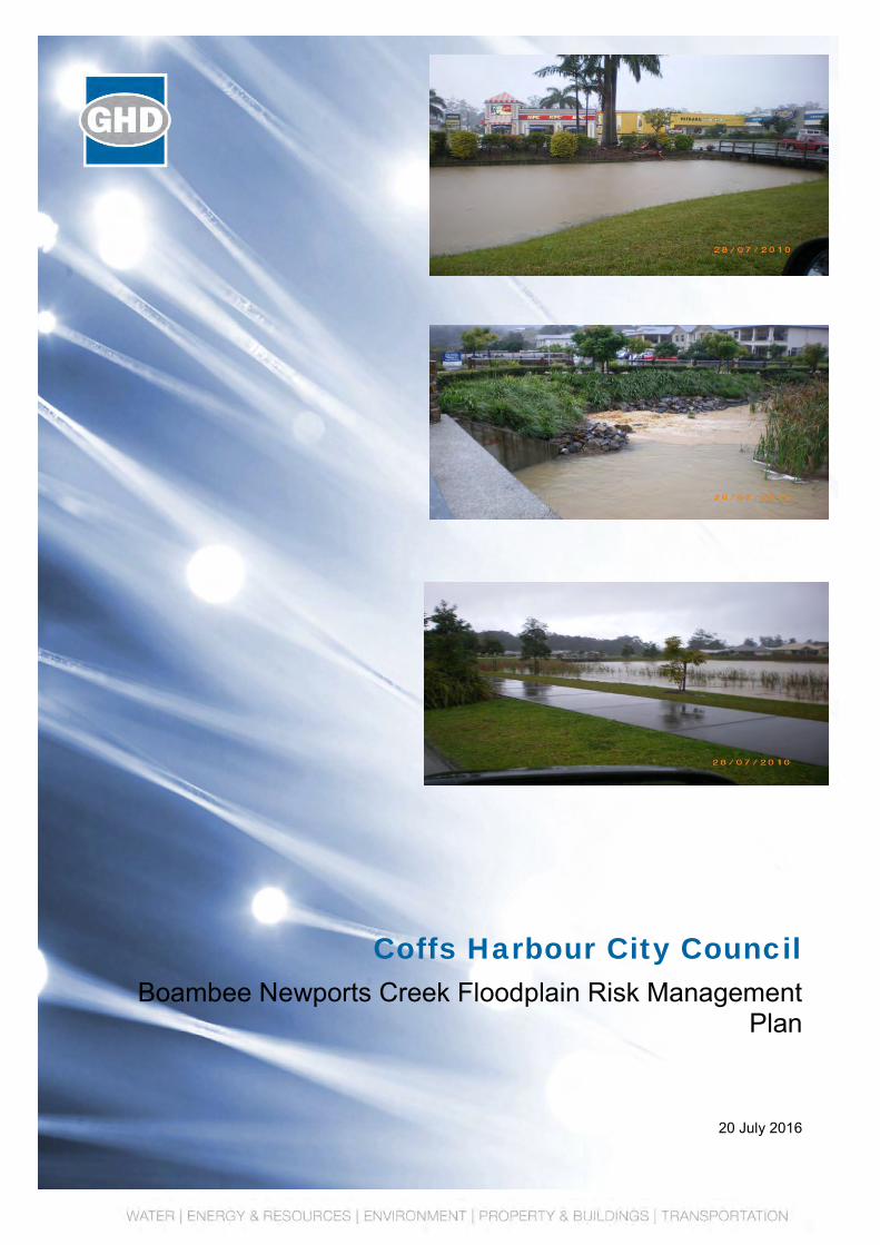
Coffs Harbour City Council
Boambee Newports Creek Floodplain Risk Management Plan
20 July 2016


GHD | Report for Coffs Harbour City Council - Boambee Newports Creek Floodplain Risk Management Plan, 22/16407 |
i
Table of contents
1. Introduction..................................................................................................................................... 1
1.1 Background .......................................................................................................................... 1
1.2 Purpose of the Plan ............................................................................................................. 1
2. Flood Situation ............................................................................................................................... 2
2.1 Historic ................................................................................................................................. 2
2.2 Flood Behaviour ................................................................................................................... 2
3. Flood Damages .............................................................................................................................. 4
4. Recommended Floodplain Management Measures ...................................................................... 5
4.1 Property modification ........................................................................................................... 5
4.2 Response modification......................................................................................................... 6
4.3 Flood modification ................................................................................................................ 8
5. Funding and Implementation........................................................................................................ 16
5.1 Funding .............................................................................................................................. 16
5.2 Plan Costs .......................................................................................................................... 16
5.3 Implementation .................................................................................................................. 16
5.4 Plan Review ....................................................................................................................... 17
6. References ................................................................................................................................... 19
Table index
Table 2-1 Summary of Flooding at Key Locations ............................................................................... 3
Table 3-1 Dwellings likely to experience over floor flooding ................................................................ 4
Table 3-2 Damage Summary ............................................................................................................... 4
Table 4-1 North Boambee Valley (West) Basin Data........................................................................... 8
Table 4-2 Dwelling Floor Levels Inundated .......................................................................................... 9
Table 4-3 Critical Locations for ongoing maintenance ....................................................................... 12
Table 4-4 Flood impacts as a result of Options PC24 and PC25* ..................................................... 14
Table 4-5 Staging for PC24, PC25 & PC26 ....................................................................................... 14
Table 5-1 Option Benefit Cost Ratio, Cost and Ranking ........................................................................ 18
Figure index
Figure 1-1 Boambee, Newports and Cordwells Creek floodplains ....................................................... 1
Figure 4-1 Floodplain Management Measures ..................................................................................... 5
Figure 5-1 Implementation Plan .......................................................................................................... 17

ii | GHD | Report for Coffs Harbour City Council - Boambee Newports Creek Floodplain Risk Management Plan, 22/16407
Appendices
Appendix A Study Area Map and Key Locations
Appendix B Flood Mapping, incorporating model updates
Appendix C Flood Mitigation Options – Concept Sketches
GHD | Report for Coffs Harbour City Council - Boambee Newports Creek Floodplain Risk Management Plan, 22/16407 | 1
1. Introduction
1.1 Background
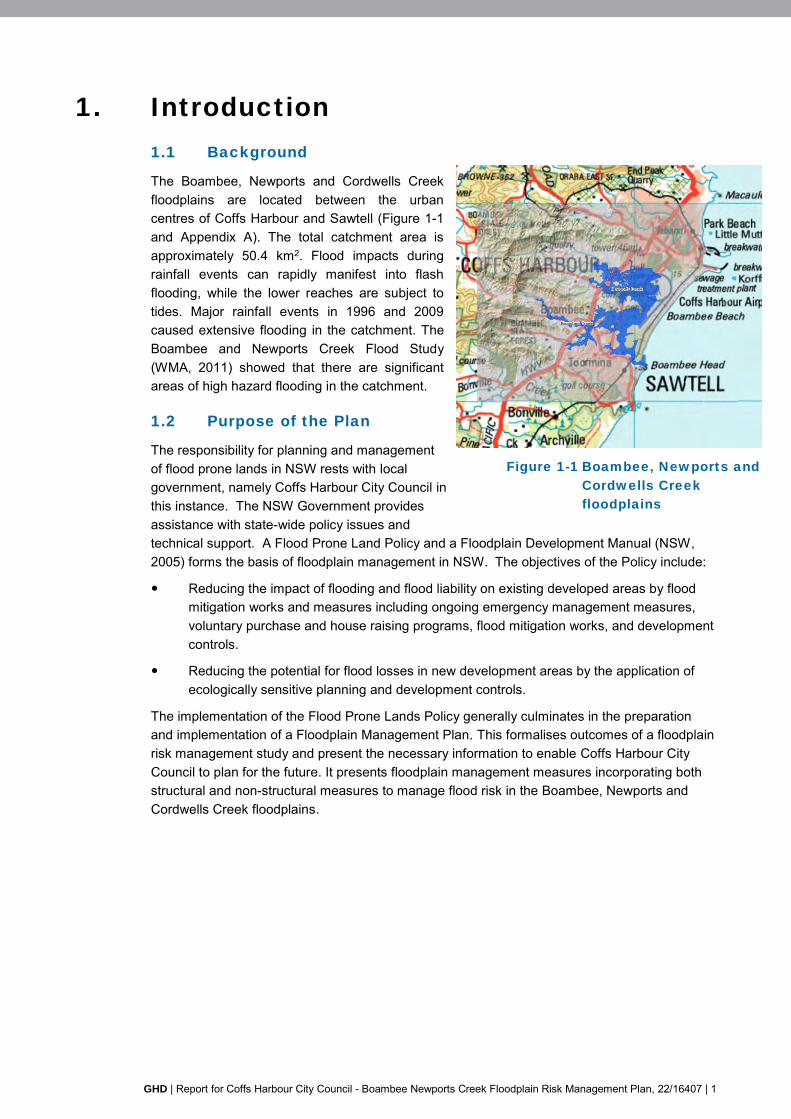
The Boambee, Newports and Cordwells Creek floodplains are located between the urban centres of Coffs Harbour and Sawtell (Figure 1-1 and Appendix A). The total catchment area is approximately 50.4 km2. Flood impacts during rainfall events can rapidly manifest into flash flooding, while the lower reaches are subject to tides. Major rainfall events in 1996 and 2009 caused extensive flooding in the catchment. The Boambee and Newports Creek Flood Study (WMA, 2011) showed that there are significant areas of high hazard flooding in the catchment.
1.2 Purpose of the Plan
The responsibility for planning and management of flood prone lands in NSW rests with local government, namely Coffs Harbour City Council in this instance. The NSW Government provides assistance with state-wide policy issues and technical support. A Flood Prone Land Policy and a Floodplain Development Manual (NSW, 2005) forms the basis of floodplain management in NSW. The objectives of the Policy include:
Reducing the impact of flooding and flood liability on existing developed areas by flood mitigation works and measures including ongoing emergency management measures, voluntary purchase and house raising programs, flood mitigation works, and development controls.
Reducing the potential for flood losses in new development areas by the application of ecologically sensitive planning and development controls.
The implementation of the Flood Prone Lands Policy generally culminates in the preparation and implementation of a Floodplain Management Plan. This formalises outcomes of a floodplain risk management study and present the necessary information to enable Coffs Harbour City Council to plan for the future. It presents floodplain management measures incorporating both structural and non-structural measures to manage flood risk in the Boambee, Newports and Cordwells Creek floodplains.
Newports Creek
Boambee Creek
Figure 1-1 Boambee, Newports and
Cordwells Creek
floodplains

2 | GHD | Report for Coffs Harbour City Council - Boambee Newports Creek Floodplain Risk Management Plan, 22/16407
2. Flood Situation
2.1 Historic
Major rainfall events in 1996 and 2009 caused extensive flooding in the catchment. The Coffs Coast Recovery Committee (CCRC) report includes information on the social and economic impacts of the 2009 flood on the community. It documents the isolation of several hundred people at workplaces and schools within the catchment, with approximately 900 people stranded at Bishop Druitt College until 11pm, with some 150 sleeping over. Four students were required to be medically evacuated to hospital for diabetes and epilepsy conditions. The Coffs Harbour Health Campus (CHHC) was completely isolated, resulting in the activation of the Campus Disaster Plan due to flooding of premises and buildings. Damage occurred to records and equipment, emergency services were disrupted (requiring diversion of ambulances to Macksville and Grafton) and some 600 staff, outpatients and visitors required to be registered and evacuated to the main hospital building. The costs incurred at this facility during the course of the 2009 flood due to damage and clean-up were estimated by hospital staff to be approximately $500,000, which included damage to vehicles.
A key recommendation of the Coffs Coast Recovery Committee report is that the CHHC be identified as a critical service/infrastructure within the LGA.
2.2 Flood Behaviour
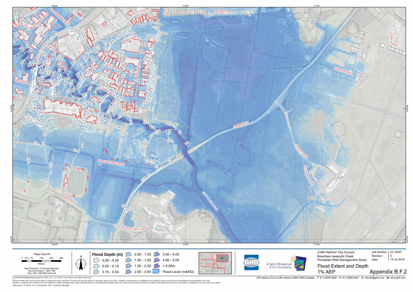
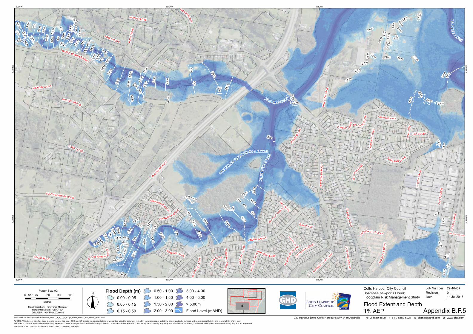
The Boambee Newports Creek Flood Study (WMA, 2011) prepared flood mapping together with hydraulic and flood hazard categorisation mapping. Since the current project required an update of the flood model to incorporate recent developments within the catchments the original flood mapping has not been reproduced to avoid confusion. Instead, the updated flood mapping, incorporating all recent model updates, has been provided in Appendix B.
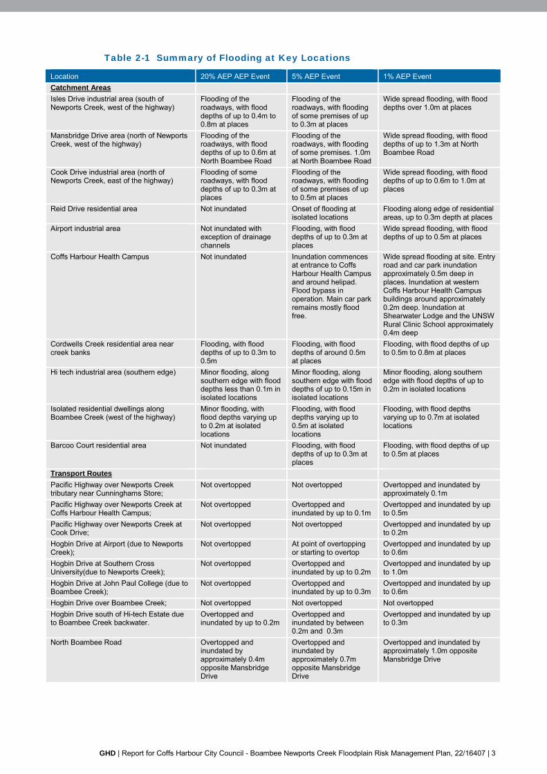
With reference to the key flood affected areas and transport routes, Table 2-1 summarises the flooding at these locations in a 20% AEP, 5% AEP and 1 % AEP event.
Flood velocities are generally low (well below 0.5 m/s) in the lower parts of the catchment. Higher velocities are associated with Boambee Creek, at road over flows, constrictions in the floodplain and at the Boambee mouth. In these areas velocities in the order of 1 m/s are noted. In the upper creeks isolated areas of elevated velocities can be expected, where creek inverts are steeper.
High hazard areas associated with flood depth are noted in the lower floodplain and creek channels. In the Isles Drive, Mansbridge Drive and Cook Drive industrial areas, high hazard areas are confined to the channels, with the adjacent developed areas noted as low hazard.
In Boambee Creek, west of the Pacific Highway, high hazard areas are associated with the creek channels with the adjacent floodplain being low hazard.
In general terms, flood peaks first manifest in the upper Middle Boambee and North Boambee catchments manifest as flood peaks:
Approximately 1.5 hours later at the Pacific Highway.
Approximately 6.0 hours later at the Boambee Newports Creek confluence.
Approximately 7.0 hours later at the mouth of Boambee Creek.
Thus flooding west of the highway is expected to manifest rapidly and warning times are short. East of the highway there is more opportunity to respond to flood warnings.
GHD | Report for Coffs Harbour City Council - Boambee Newports Creek Floodplain Risk Management Plan, 22/16407 | 3
Table 2-1 Summary of Flooding at Key Locations
Location 20% AEP AEP Event 5% AEP Event 1% AEP Event Catchment Areas
Isles Drive industrial area (south of Newports Creek, west of the highway)
Flooding of the roadways, with flood depths of up to 0.4m to 0.8m at places
Flooding of the roadways, with flooding of some premises of up to 0.3m at places
Wide spread flooding, with flood depths over 1.0m at places
Mansbridge Drive area (north of Newports Creek, west of the highway)
Flooding of the roadways, with flood depths of up to 0.6m at North Boambee Road
Flooding of the roadways, with flooding of some premises. 1.0m at North Boambee Road
Wide spread flooding, with flood depths of up to 1.3m at North Boambee Road
Cook Drive industrial area (north of Newports Creek, east of the highway)
Flooding of some roadways, with flood depths of up to 0.3m at places
Flooding of the roadways, with flooding of some premises of up to 0.5m at places
Wide spread flooding, with flood depths of up to 0.6m to 1.0m at places
Reid Drive residential area Not inundated Onset of flooding at isolated locations
Flooding along edge of residential areas, up to 0.3m depth at places
Airport industrial area Not inundated with exception of drainage channels
Flooding, with flood depths of up to 0.3m at places
Wide spread flooding, with flood depths of up to 0.5m at places
Coffs Harbour Health Campus Not inundated Inundation commences at entrance to Coffs Harbour Health Campus and around helipad. Flood bypass in operation. Main car park remains mostly flood free.
Wide spread flooding at site. Entry road and car park inundation approximately 0.5m deep in places. Inundation at western Coffs Harbour Health Campus buildings around approximately 0.2m deep. Inundation at Shearwater Lodge and the UNSW Rural Clinic School approximately 0.4m deep
Cordwells Creek residential area near creek banks
Flooding, with flood depths of up to 0.3m to 0.5m
Flooding, with flood depths of around 0.5m at places
Flooding, with flood depths of up to 0.5m to 0.8m at places
Hi tech industrial area (southern edge) Minor flooding, along southern edge with flood depths less than 0.1m in isolated locations
Minor flooding, along southern edge with flood depths of up to 0.15m in isolated locations
Minor flooding, along southern edge with flood depths of up to 0.2m in isolated locations
Isolated residential dwellings along Boambee Creek (west of the highway)
Minor flooding, with flood depths varying up to 0.2m at isolated locations
Flooding, with flood depths varying up to 0.5m at isolated locations
Flooding, with flood depths varying up to 0.7m at isolated locations
Barcoo Court residential area Not inundated Flooding, with flood depths of up to 0.3m at places
Flooding, with flood depths of up to 0.5m at places
Transport Routes
Pacific Highway over Newports Creek tributary near Cunninghams Store;
Not overtopped Not overtopped Overtopped and inundated by approximately 0.1m
Pacific Highway over Newports Creek at Coffs Harbour Health Campus;
Not overtopped Overtopped and inundated by up to 0.1m
Overtopped and inundated by up to 0.5m
Pacific Highway over Newports Creek at Cook Drive;
Not overtopped Not overtopped Overtopped and inundated by up to 0.2m
Hogbin Drive at Airport (due to Newports Creek);
Not overtopped At point of overtopping or starting to overtop
Overtopped and inundated by up to 0.6m
Hogbin Drive at Southern Cross University(due to Newports Creek);
Not overtopped Overtopped and inundated by up to 0.2m
Overtopped and inundated by up to 1.0m
Hogbin Drive at John Paul College (due to Boambee Creek);
Not overtopped Overtopped and inundated by up to 0.3m
Overtopped and inundated by up to 0.6m
Hogbin Drive over Boambee Creek; Not overtopped Not overtopped Not overtopped Hogbin Drive south of Hi-tech Estate due to Boambee Creek backwater.
Overtopped and inundated by up to 0.2m
Overtopped and inundated by between 0.2m and 0.3m
Overtopped and inundated by up to 0.3m
North Boambee Road Overtopped and inundated by approximately 0.4m opposite Mansbridge Drive
Overtopped and inundated by approximately 0.7m opposite Mansbridge Drive
Overtopped and inundated by approximately 1.0m opposite Mansbridge Drive

4 | GHD | Report for Coffs Harbour City Council - Boambee Newports Creek Floodplain Risk Management Plan, 22/16407
3. Flood Damages
Residential damage calculations were undertaken using the recommended methods of the Floodplain Management and Coastal Support Section of the former Department of Natural Resources (DNR, now Office of Environment and Heritage). For commercial damages the Queensland Governments Natural Resources and Mines Guidelines on the Assessment of Tangible Flood Damages (2002) was used. This assessment guideline uses commercial damage curves reproduced from the original ANUFLOOD program (CRES,1992) and adjusted by CPI to March 2013 figures. In addition to the estimated direct damages, this damage assessment includes additional indirect/ intangible damages applied to the tangible damages.
Table 3-1 lists the numbers of properties in the Boambee Newports Creek catchment affected by flooding based on the recent floor level survey and the revised flood levels. A total 622 properties were noted as being within the PMF flood extent.
Table 3-1 Dwellings likely to experience over floor flooding
AEP Numbers of Premises* Residential Commercial TOTAL 20% 0 6 6 5% 0 35 35 1% 26 83 109 PMF 289 220 509
*Note: 622 dwellings/properties located within the PMF flood extent
The damage for flooding in the Boambee Newports catchment was calculated be Net Present Value (NPV) $9.87 million over 20 years at 7%. The total damage, including both direct and indirect damages was calculated to be a Net Present Value (NPV) $14.31 million over 20 years at 7%, with a further $2.86 million attributable to motor vehicle damage.
Table 3-2 Damage Summary
Residential (AEP)
Direct ($ million)
Direct plus Indirect ($ million)
Motor vehicle damage ($ million)
Annual Average Damage 0.85 1.23 0.25
Net Present Value (20 years at 7%)
9.87 14.31 2.86
GHD | Report for Coffs Harbour City Council - Boambee Newports Creek Floodplain Risk Management Plan, 22/16407 | 5
4. Recommended Floodplain
Management Measures
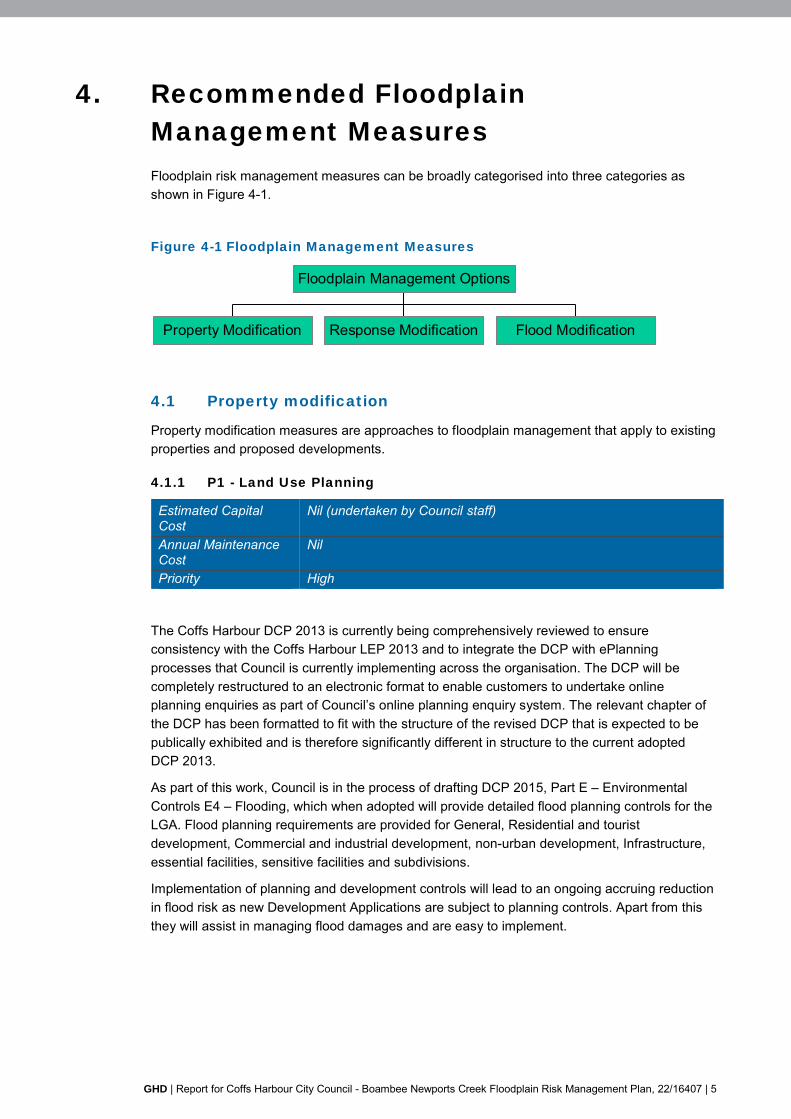
Floodplain risk management measures can be broadly categorised into three categories as shown in Figure 4-1.
Figure 4-1 Floodplain Management Measures
Property Modification Response Modification Flood Modification
Floodplain Management Options
4.1 Property modification
Property modification measures are approaches to floodplain management that apply to existing properties and proposed developments.
4.1.1 P1 - Land Use Planning
Estimated Capital Cost
Nil (undertaken by Council staff)
Annual Maintenance Cost
Nil
Priority High
The Coffs Harbour DCP 2013 is currently being comprehensively reviewed to ensure consistency with the Coffs Harbour LEP 2013 and to integrate the DCP with ePlanning processes that Council is currently implementing across the organisation. The DCP will be completely restructured to an electronic format to enable customers to undertake online planning enquiries as part of Council’s online planning enquiry system. The relevant chapter of the DCP has been formatted to fit with the structure of the revised DCP that is expected to be publically exhibited and is therefore significantly different in structure to the current adopted DCP 2013.
As part of this work, Council is in the process of drafting DCP 2015, Part E – Environmental Controls E4 – Flooding, which when adopted will provide detailed flood planning controls for the LGA. Flood planning requirements are provided for General, Residential and tourist development, Commercial and industrial development, non-urban development, Infrastructure, essential facilities, sensitive facilities and subdivisions.
Implementation of planning and development controls will lead to an ongoing accruing reduction in flood risk as new Development Applications are subject to planning controls. Apart from this they will assist in managing flood damages and are easy to implement.
6 | GHD | Report for Coffs Harbour City Council - Boambee Newports Creek Floodplain Risk Management Plan, 22/16407
4.2 Response modification
Response modification measures are reactions to flooding that reduce potential social, economic and environmental damages from flooding. While response modifications will reduce the risk to life, they will not prevent flooding. Therefore, they will not address all the social impacts and reduce damages associated with flooding.
4.2.1 P4 – Flood Information/Data and Flood Warning/Public Flood
Awareness
Flood Information
Estimated Capital Cost
$80 000
Annual Maintenance Cost
Nil
Priority Low
Comprehensive and up to date flood information is essential in managing and responding to flood events and to guide future development in flood prone areas. As part of this option, it is recommended that the WBNM hydrological model be updated. This should include a review of rainfall data and rationalisation of the current Mike11 and TUFLOW models (of differing grid size) into a single TUFLOW model, of a more recent model version.
The flood study review should capture flood information (levels, depths, velocities, hydraulic and hazard categories) throughout the catchment, within Councils GIS system for ready access.
Rainfall and Flow Gauging
Estimated Capital Cost
$20 000 (North Boambee Basin) + $20 000 (Ayrshire Road)
Annual Maintenance Cost
$2000 + $2000
Priority Low
For the Newports Creek catchment it is considered that there are adequate rain and level gauge data monitoring stations within the catchment. In the event of development in the North Boambee area, which would require a detention basin, it is recommended that a further gauge be installed at the basin site. The Middle Boambee Valley has no gauging stations associated west of the Pacific Highway. It is recommended that a combined rainfall/water level gauging station be installed within this valley, potentially at Ayrshire Road (west). This rainfall station would supplement the rainfall monitoring for the overall catchment. In addition, it would assist in early flood warning for properties in the Lindsay’s Road area.
SES Flood Information
Estimated Capital Cost
Nil
Annual Maintenance Cost
Nil
Priority High

GHD | Report for Coffs Harbour City Council - Boambee Newports Creek Floodplain Risk Management Plan, 22/16407 | 7
The SES manages the Coffs Harbour City Council, Local Flood Plan (SES 2015) and the Coffs Harbour City Flood Emergency Sub Plan which is a sub plan of the Coffs Harbour City Local Emergency Management Plan (EMPLAN). This plan nominates that the NSW SES Coffs Harbour City Local Controller is responsible for dealing with floods as detailed in the State Flood Plan. The plan is supported by:
The Coffs Harbour Residential Floodsafe Brochure
The Coffs Harbour Business Floodsafe Brochure
The Coffs Harbour City Council, Local Flood Plan (SES 2015), which was updated during the timeframe of this study, is a considerable update from the previous 2012 version. The latest plan now includes and discusses flooding in Boambee and Newports Creek. The Coffs Harbour City Council, Local Flood Plan (SES 2015) would benefit from some flood mapping to show inundation in the Boambee and Newports Creek catchments.
In a meeting with the SES (November 2015), the following data was requested to support the local Coffs Harbour SES operations:
The Floodplain Risk Management Study was to validate the Boambee Newports Creek parts to Volume 3 Chapter 2 Coffs Harbour City Council, Local Flood Plan (SES 2015), including:
– Flood model data presented.
– Evacuation routes recommended.
Floodplain Risk Management Study is to provide an updated Floor Level Inundation map that also shows the gauges within the catchment and is supported by a spreadsheet of property data, being address, floor level and design flood level for affected properties.
An estimate of the travel time of the flood wave from the Industrial Drive site, and from the Industrial Drive gauging site to the main entrance of the hospital.
The validation tasks were completed and will be delivered to the SES directly, for input to updates to the Coffs Harbour City Council, Local Flood Plan (SES 2015) document. The Floor Level Inundation Plan has been compiled and, with the spreadsheet of property data, has been delivered to the SES directly (copied to Council). The estimate of travel times for flood wave is approximately 30 minutes to 45 minutes between Industrial Drive gauging site to the main entrance of the hospital.

8 | GHD | Report for Coffs Harbour City Council - Boambee Newports Creek Floodplain Risk Management Plan, 22/16407
4.3 Flood modification
Flood modification measures are those that alter the flood conditions to reduce the flood hazard or change the flood behaviour. Flood modification is generally the only measures that will minimise both the social impacts and the risk to property and life.
4.3.1 P6 - Flood Mitigation Basin in North Boambee Valley
Estimated Capital Cost
$2.99 Million (on basis that 63% of basin cost attributable to flood mitigation)
Annual Maintenance Cost
$10 000
Priority Medium/High
The June 2013 the North Boambee Valley (West) Flood Study (CHCC 2013) was completed to inform the potential rezoning of this part of the North Boambee catchment. The study investigated detention basin and floodway options that would allow development in flood prone areas to proceed. In addition, detention basins were recommended that would potentially benefit downstream flood prone areas, in and around the Isles Drive and Cook Drive commercial areas.
Further detailed investigations were undertaken which included optimisation of the outlets of a future detention basin in the North Boambee Valley. The recommended basin configuration entailed a single detention basin on one of the larger tributaries draining the North Boambee Valley. The recommended basin would control discharge from approximately two-thirds of the catchment, being primarily located on a tributary of Newports Creek, immediately north of Englands Road. The basin would have 3 x 3.6m by 1.5m outlets (Option 4).
This basin showed reduced flooding to premises and dwellings in the downstream catchment, and reduced flood damages in the commercial of Isles Drive, Mansfield Drive and Cook Drive. The North Boambee Valley (West) Flood Study (CHCC 2013) investigated cost apportionment of the basin to the North Boambee Valley (West) development, the Pacific Highway bypass and the downstream flood mitigation works. It was suggested that 63% of the basin cost could be apportioned to the downstream flood mitigation function. Note the figure of 63% has been calculated based on the benefits accruing from offsetting the impact of the future highway diversion and future residential development in the area. There is no guarantee that funding for part of the cost of this option will be forthcoming from these sources in the future. Funding sources and opportunities will need to be investigated as part of the project. The results showed a reduction in NPV damage of $3.5M. Assuming a cost of $2.99M for the basin (ie 63%), this would equate to a benefit/cost ratio of 1.17.
Table 4-1 North Boambee Valley (West) Basin Data
Item Data Top of wall 24 m AHD Crest Width 6m (12m along road) Wall length 390m Side slopes 1 in 3
North Boambee
Valley Basin
Flood impacts not
Shown in this area

GHD | Report for Coffs Harbour City Council - Boambee Newports Creek Floodplain Risk Management Plan, 22/16407 | 9
Item Data Outlets 3 by 3.6 x 1.5m 1% AEP top water level Not provided by CHCC 2013, however modelled as part of this study
to be 22.5 m AHD (6hr storm) 0.2% AEP top water level (approx. volume)
23.6 m AHD (343 ML)
4.3.2 P9 – Levees, Filling and Berms to Divert Flow
Berm Levee at Barcoo Court
Estimated Capital Cost
$640 000
Annual Maintenance Cost
$4 000
Priority Medium/Low
A levee at Barcoo Court (see Appendix C for a concept sketch), within the lowered reaches of the Boambee and Newports floodplain where slow moving flood waters discharge over longer durations, was shown to reduce flooding to lots and dwellings. In this area dwellings are likely to be inundated between the 5% AEP and 1% AEP flood event as tabulated below.
Table 4-2 Dwelling Floor Levels Inundated
Event Barcoo Court
Approximate Lots affected by flooding
Floors Inundated
20% AEP 6 0
5% AEP 35 0
1% AEP 40 13
0.5% AEP Not assessed 30
PMF Not assessed 49
Since the levee footprint at Barcoo Court would impact on the adjacent SEPP 14 wetland area, a concrete levee cross-section along the lot boundary was assessed. In consideration of the numbers of floor levels inundated at differing flood events, a 1% AEP levee was considered. For reasons of aesthetics, the levee was not provided with any freeboard above the 1% flood level, at this stage.
A benefit/cost assessment was undertaken and the results showed a favourable benefit/cost ratio of 0.98, based on a NPV flood damage saving of $0.62 million and a levee cost of $640,000. A further consideration is future climate, where dwellings in this area may benefit from a levee to counteract the risk of inundation, due to future sea level rise.
10 | GHD | Report for Coffs Harbour City Council - Boambee Newports Creek Floodplain Risk Management Plan, 22/16407
4.3.3 P10 - Isles Drive Bypass Channel Improvements (P10) with Pacific
Highway Conveyance improvements at Cunningham’s Store (P16)
Estimated Capital Cost
$1.17 Million (with culvert amplification under highway) $433 000 (with median lowering at highway)
Annual Maintenance Cost
$8 000
Priority High
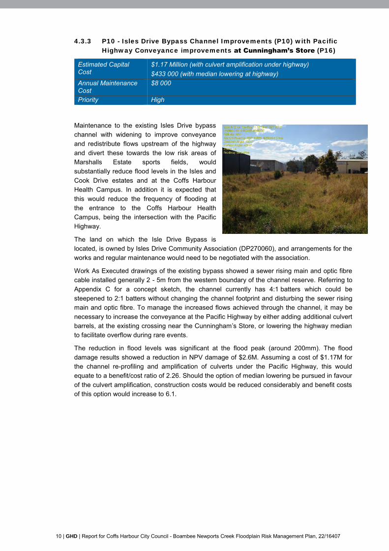
Maintenance to the existing Isles Drive bypass channel with widening to improve conveyance and redistribute flows upstream of the highway and divert these towards the low risk areas of Marshalls Estate sports fields, would substantially reduce flood levels in the Isles and Cook Drive estates and at the Coffs Harbour Health Campus. In addition it is expected that this would reduce the frequency of flooding at the entrance to the Coffs Harbour Health Campus, being the intersection with the Pacific Highway.
The land on which the Isle Drive Bypass is located, is owned by Isles Drive Community Association (DP270060), and arrangements for the works and regular maintenance would need to be negotiated with the association.
Work As Executed drawings of the existing bypass showed a sewer rising main and optic fibre cable installed generally 2 - 5m from the western boundary of the channel reserve. Referring to Appendix C for a concept sketch, the channel currently has 4:1 batters which could be steepened to 2:1 batters without changing the channel footprint and disturbing the sewer rising main and optic fibre. To manage the increased flows achieved through the channel, it may be necessary to increase the conveyance at the Pacific Highway by either adding additional culvert barrels, at the existing crossing near the Cunningham’s Store, or lowering the highway median to facilitate overflow during rare events.
The reduction in flood levels was significant at the flood peak (around 200mm). The flood damage results showed a reduction in NPV damage of $2.6M. Assuming a cost of $1.17M for the channel re-profiling and amplification of culverts under the Pacific Highway, this would equate to a benefit/cost ratio of 2.26. Should the option of median lowering be pursued in favour of the culvert amplification, construction costs would be reduced considerably and benefit costs of this option would increase to 6.1.

GHD | Report for Coffs Harbour City Council - Boambee Newports Creek Floodplain Risk Management Plan, 22/16407 | 11
4.3.1 P20 - O’Keefe Drive Local Flood Relief
Estimated Capital Cost
$1 500
Annual Maintenance Cost
Nil
Priority Low
To facilitate increased conveyance in Newports Creek, and to assist drainage from the Cook Drive estate, the regrading of land at the end of O’Keefe Drive in an easterly direction should be pursued. This would allow flood waters to escape at the eastern extent of O’Keefe Drive. The implementation of this channel was shown to reduce flood levels in a 1% AEP event by approximately 5 mm to 10 mm at the southern end of Wingara Drive.
The localised benefit of this option is considered minor and is unlikely to have an impact on flood damages. Further detailed investigation of this option was thus not considered warranted, however the option of grading land at the end of O’Keefe Drive in an easterly direction, allowing flood waters to escape, can be reasonably easily implemented and should be retained.
4.3.2 P21 - New Bunnings channel widening/formalisation
Estimated Capital Cost
$310 000
Annual Maintenance Cost
$7 000
Priority Low
The channel adjacent to the southern boundary of the new Bunnings site is located in a 10m wide easement. While the actual channel is narrower, properties located along the southern edge of the boundary encroach on the easement. These properties are generally low-set and highly flood prone. Widening the channel to the fill easement capacity could assist general conveyance in this area potentially drawing down flood levels. In addition this widening may offset any fill platforms which may allow future redevelopment of the lots south of the channel.
This option should be retained and implemented should redevelopment of the properties along the south bank of the channel be considered in the future, when the full easement can be utilised. The benefits of this option may also offset potential future fill platforms and provide further benefits during more frequent events.
4.3.3 P22 – Regular maintenance of creeks, culverts, flood bypasses and
detention basins
Estimated Capital Cost
nil
Annual Maintenance Cost
$7 000 (estimate 11 locations, with 1 to 2 days maintenance at each location)
Priority High
Regular maintenance of channels, flood bypass and detention basins, is imperative in order that these facilities operate optimally and as originally intended. A number of critical areas have been identified throughout the floodplain, where a build-up of sediment, erosion and/or vegetation management will be important to ongoing maintenance.

12 | GHD | Report for Coffs Harbour City Council - Boambee Newports Creek Floodplain Risk Management Plan, 22/16407
Table 4-3 Critical Locations for ongoing maintenance
Location Issues Risks Culverts and bridges along the Pacific Highway (Newports Creek at CHHC, at Cunninghams Store, at KFC, under new Bunnings store), and culverts within Lakes Estate
Maintain conveyance, remove vegetation/sediment
Elevated flood levels, highway overflow and inundation of surrounding properties
Coffs Harbour Health Campus floodway
Maintain conveyance, remove vegetation/sediment, mow
Inefficient conveyance leading to elevated flood levels and inundation at Coffs Harbour Health Campus
Culverts and basins within Lakes Estate
Maintain conveyance, remove vegetation/sediment
Elevated flood levels, highway overflow and inundation of surrounding properties
Isle Drive diversion basin Maintain conveyance, remove vegetation/sediment particularly at inlets and outlets
Reduced detention, redirection of flows, inefficient operation
Isles Drive bypass channel Maintain conveyance through channel, remove vegetation/sediment
Inefficient conveyance leading to elevated flood levels, redirection of flows and inundation at Isles Drive
Spoonbill Lake Maintain conveyance of inlets and outlets, remove vegetation/sediment
Maintenance required to facilitate local drainage
Sawtell Bridge Maintain conveyance, remove vegetation/sediment
Increased backwater, leading to elevated flood levels and inundation of surrounding properties
Lindsay Road culverts and channels
Maintain conveyance, remove vegetation/sediment
Increased flood risk to adjacent lower lying dwellings
Hogbin Drive culvert at Hitech Estate
Maintain conveyance, remove vegetation/sediment
Potential flood risk to commercial properties in Hi tech Drive
Drainage channels in and around Hogbin Drive and Airport Drive
Maintain conveyance, remove vegetation/sediment
Risk of Hogbin Drive inundation, elevated flood levels, and inefficient drainage
Drainage channel adjacent to new Bunnings building
Maintain conveyance, remove vegetation/sediment
Inefficient conveyance leading to elevated flood levels and inundation of surrounding properties
GHD | Report for Coffs Harbour City Council - Boambee Newports Creek Floodplain Risk Management Plan, 22/16407 | 13
4.3.4 PC24, PC25 and PC26 – Combined options incorporating P13, P14,
P10, P6 and potentially P16 to mitigate PC24
Estimated Capital Cost
PC24 -$0.9 Million ( P13, P10 & P14) PC25 -$3.9 Million ( P6, P13, P10 & P14) PC26 -$0.9 Million ( P13, P10, P14 & P16)
Annual Maintenance Cost
PC24 - $20 000 PC25 - $30 000 PC26- $20 000
Priority PC24 - High PC25 – Medium PC26 - High
Combining options in Newports Creek floodplain was shown to have considerable benefits. The recommended combination of options is:
P13: Coffs Harbour Health Campus Floodway - To counteract the downstream flood level increases due to option P14, the Coffs Harbour Health Campus floodway would be enhanced (see Appendix C, Figure PC24.2 for a concept sketch). On the upstream extent, the floodway would involve widening the narrowing at the head of the Speciality Medical Centre car park by reshaping of the landform. On the downstream extent the floodway would be regraded, the batters steepened and the narrowing at the access road to Shearwater lodge would be removed. A further floodway would be provided east of Shearwater lodge.
P10: Isles Drive Bypass Channel – The Isle Drive bypass improvements, as discussed in Section 4.3.3, however no allowance is included for conveyance improvements at the Pacific Highway in Options PC24 and PC25. If median removal is adopted the cost will be minor compared to the overall cost of the option.
P14: Remove Newports Bridge Gabion Constriction – The Pacific Highway crossing over Newports Creek has a left and right bank gabion constriction at the upstream inlet. Council could not provide any history on the construction of the gabion structure. Removal of the left and right bank gabion constriction at the upstream inlet of the Pacific Highway crossing over Newports Creek would reduced flood levels upstream of the Pacific Highway by 150 mm to 300 mm, lessening upstream. This would however increase flows downstream as more conveyance is provided through the bridge.
P6: Flood mitigation basin in North Boambee Valley – The flood mitigation basin in the North Boambee Valley, as discussed in Section 4.3.1.
P16: Pacific Highway crossing conveyance improvements. If flows through the Isles Drive bypass would be increased, increasing the conveyance at the Pacific Highway may be required to manage increased flood levels upstream of the Pacific Highway. Should additional culverts prove to be costly and difficult considering constructability, then lowering of the median in this location may be an option.
The combination of options resulted in the following additional mitigation options:
PC24, which included P13: Coffs Harbour Health Campus Floodway, P10: Isles Drive Bypass Channel and P14: Remove Newports Bridge Gabion Constriction
PC25, which is PC24 plus P6: Flood mitigation basin in North Boambee Valley
PC26. which is PC24 plus P16: Pacific Highway crossing conveyance improvements
14 | GHD | Report for Coffs Harbour City Council - Boambee Newports Creek Floodplain Risk Management Plan, 22/16407
Flood simulations showed significant reductions in flood levels at the flood peak, particularly during smaller more frequent events. The results were used in a flood damage calculation to determine the reduction in flood damages provided by the option. The results showed:
PC24: A reduction in NPV damage of $3.9M. Assuming a cost of $0.9M for the channel re profiling and other works, this would equate to a benefit/cost ratio of 4.24.
PC25: A reduction in NPV damage of $5.1M. Assuming a cost of $3.9M for the channel re profiling and 63% of the cost of the North Boambee basin, this would equate to a benefit/cost ratio of 1.30. Note the figure of 63% has been calculated based on the benefits accruing from offsetting the impact of the future highway diversion and future residential development in the area. There is no guarantee that funding for part of the cost of this option will be forthcoming from these sources in the future. Funding sources and opportunities will need to be investigated as part of the project
PC26: Similair to PC24, since the cost of lowering the median at the Pacific Highway is expected to be a minor cost.
Table 4-4 Flood impacts as a result of Options PC24 and PC25*
Location 1% AEP 9hr storm Option: PC24*
(and PC26) PC25
Upstream of Isles Drive Bypass Channel (north Isles drive)
-160 mm -520 mm
Cook Drive commercial area -100 mm -420 mm Downstream of Isles Drive Bypass Channel (Isle Drive wetland)
+230 mm (+80mm for PC26)
+95 mm
Downstream of Pacific Highway Culverts (Marshalls Estate Sportsfields)
+100 mm +30 mm
Coffs Harbour Health Campus -120mm -550mm
*Note PC24 does not included conveyance improvements at the Pacific Highway crossing near Cunningham’s Store.
PC25 includes the flood mitigation basin in the North Boambee Valley.
Both option PC24 and PC25 have significant widespread benefits in lowering flood levels in the middle floodplain of Newports Creek, around the Pacific Highway, which includes areas in Isles Drive and Cook Drive commercial areas and at the Coffs Harbour Health Campus. Option PC26 would counter flood level increases downstream of Isles Drive Bypass Channel (Isle Drive wetland) by lowering the Pacific Highway median. Option PC24, without the North Boambee basin option, would reduce overall damage costs by some 25%. This would increase to some 33% with the inclusion of the North Boambee basin option. It is recommended that the works be staged as follows:
Table 4-5 Staging for PC24, PC25 & PC26
Stage Works Stage 1 P13 – widen the Coffs Harbour Health Campus floodway
by providing a 1 in 4 channel side slopes and removing the narrowing adjacent to the Shearwater Lodge access road.
Stage 2 P10 - undertake the Isle Drive bypass improvements Stage 3 P14 – Remove the left and right bank gabion constriction
at the upstream inlet of the Pacific Highway crossing over Newports Creek
Stage 4 (potential option) P16 – Undertake Pacific Highway crossing conveyance improvements
Stage 5 P6 – Provide the flood mitigation basin in the North Boambee Valley, commensurate with development in the
GHD | Report for Coffs Harbour City Council - Boambee Newports Creek Floodplain Risk Management Plan, 22/16407 | 15
Valley
4.3.5 P27 – Conveyance improvements at North Boambee Road to reduce
the risk of isolation and frequency of road inundation
Estimated Capital Cost
$640 000
Annual Maintenance Cost
$7 000
Priority High
Improving the serviceability of North Boambee Road and reducing the frequency of road inundation during all, but particularly more frequent events, showed considerable benefits. The benefits were greater in more frequent events both with and without other proposed mitigation options. Flood immunity of North Boambee Road is provide in the 20%AEP event with no road inundation to almost the 5% AEP event, and the duration where the road remains flood free increases by a total of 2hrs. In larger events, due to the increase in flood levels upstream of the highway, it is recommended that this option be undertaken in conjunction with PC24 to offset the predicted localised increases upstream of the highway. Given the benefits this option is recommended as a mitigation option. Referring to Appendix C for a concept sketch, the proposed works comprise:
Raising North Boambee Road, at the low point between the Pacific Highway and the Lakes Estate roundabout from approximately 5.5 mAHD to 5.7 mAHD.
Increasing the culverts under North Boambee Road from the existing 5 x 1050mm RCP to 2 x 2.4 x 1.8 RCBC culverts.
Undertaking channel works upstream of North Boambee Road to improve conveyance.
Improving the grading of the floodway between North Boambee Road and the culverts under the Pacific Highway.
Providing a 2nd high level floodway upstream of the Pacific Highway between the floodway leading to the Pacific Highway culverts and Newports Creek. This will require a 3 x 1.8 x 0.9m RCBC culvert with an invert level of 5mAHD under the current access driveway leading to BCF.

16 | GHD | Report for Coffs Harbour City Council - Boambee Newports Creek Floodplain Risk Management Plan, 22/16407
5. Funding and Implementation
5.1 Funding
Funding for the implementation of the Plan could be considered from a number of sources:
State and Commonwealth funding for flood risk management measures through the NSW Office of Environment and Heritage.
Direct Council funds, for example maintenance funds.
Section 94 Contributions from future development.
Volunteer Groups that may be able to assist in maintenance of the creek corridors or other flood awareness initiatives, such as Landcare Groups and Schools.
For the structural mitigation works, Council can apply for assistance to the NSW Office of Environment and Heritage. These funds are available to implement measures that contribute to reducing existing flood problems and are typically applied on an equal shared basis of Commonwealth/State/Council. Special grant money may also be available in some cases.
Government funds are allocated on an annual basis to competing projects throughout the State and application documents are provided on the NSW Office of Environment and Heritage website. Measures that receive Government funding must be of significant benefit to the community. Funding of investigation and design activities as well as any works is normally available, however maintenance is normally the responsibility of the Council.
5.2 Plan Costs
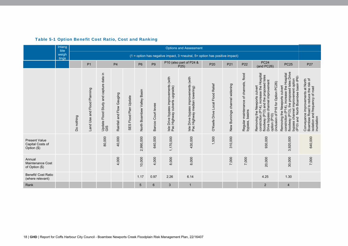
The total cost of implementing the Boambee Newports Creek Floodplain Risk Management Plan is approximately $5.6M, which includes the North Boambee basin. Maintenance costs associated with the Plan are estimated to be approximately $52 000 per annum. The net present damage savings are estimated to be $5.7M resulting in a benefit/cost ratio of 1.01 for the overall plan.
Without the North Boambee basin, the total cost of implementing the Boambee Newports Creek Floodplain Risk Management Plan is approximately $2.6M with approximately $42 000 per annum maintenance costs. The net present damage savings are estimated to be $4.6M resulting in a benefit/cost ratio of 1.73 for the overall Plan.
5.3 Implementation
In progressing the floodplain management process and implementing the Plan:
Council determines a program of works, based on overall priority, available Council funds and any other constraints.
Council submits an application for funding assistance to the NSW Office of Environment and Heritage and negotiates other sources of funding.
Implementation of the Plan proceeds, as funds become available and in accordance with established priorities.
An implimentation plan, showing option priority versus timing has been provided in Figure 5-1, with benefit -cost, cost and rankings provided in Table 5-1.
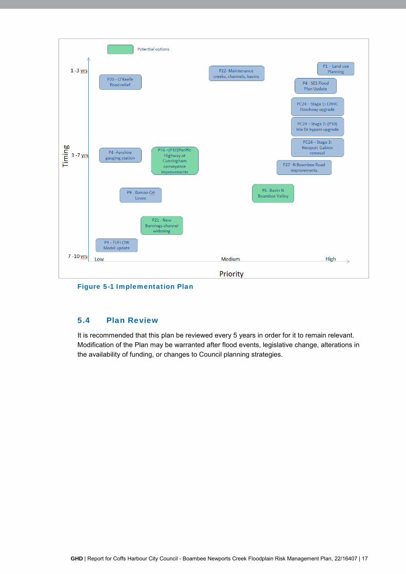
GHD | Report for Coffs Harbour City Council - Boambee Newports Creek Floodplain Risk Management Plan, 22/16407 | 17
Figure 5-1 Implementation Plan
5.4 Plan Review
It is recommended that this plan be reviewed every 5 years in order for it to remain relevant. Modification of the Plan may be warranted after flood events, legislative change, alterations in the availability of funding, or changes to Council planning strategies.
18 | GHD | Report for Coffs Harbour City Council - Boambee Newports Creek Floodplain Risk Management Plan, 22/16407
Table 5-1 Option Benefit Cost Ratio, Cost and Ranking
Intangible
weightings
Options and Assessment
(1 = option has negative impact, 3 =neutral, 5= option has positive impact)
P1 P4 P6 P9 P10 (also part of P24 & P25) P20 P21 P22 PC24
(and PC26) PC25 P27
Do
noth
ing
Land
Use
and
Flo
od P
lann
ing
Upd
ate
Floo
d S
tudy
and
cap
ture
dat
a in
G
IS
Rai
nfal
l and
Flo
w G
augi
ng
SE
S Fl
ood
Pla
n U
pdat
e
Nor
th B
oam
bee
Val
ley
Bas
in
Bar
coo
Cou
rt le
vee
Isle
Driv
e by
pass
impr
ovem
ents
(with
P
ac H
ighw
ay c
ulve
rts u
pgra
de)
Isle
Driv
e by
pass
impr
ovem
ents
(with
P
ac H
ighw
ay m
edia
n lo
wer
ing)
O'K
eefe
Driv
e Lo
cal F
lood
Rel
ief
New
Bun
ning
s ch
anne
l wid
enin
g
Reg
ular
mai
nten
ance
of c
hann
els,
floo
d by
pass
, bas
ins
Rem
ovin
g th
e N
ewpo
rts c
ulve
rt co
nstri
ctio
n (P
14),
incr
ease
the
Hos
pita
l flo
odw
ay (P
13) a
nd th
e pr
opos
ed Is
les
Driv
e by
pass
cha
nnel
impr
ovem
ent
optio
n (P
10)
(incl
usio
n of
P16
for O
ptio
n P
C26
)
Rem
ovin
g th
e N
ewpo
rts c
ulve
rt co
nstri
ctio
n (P
14),
incr
ease
the
Hos
pita
l flo
odw
ay (P
13),
the
prop
osed
Isle
s D
rive
bypa
ss c
hann
el im
prov
emen
t opt
ion
(P10
) and
Nor
th B
oam
bee
basi
n (P
6)
Con
veya
nce
impr
ovem
ents
at N
orth
B
oam
bee
Roa
d to
redu
ce th
e ris
k of
is
olat
ion
and
frequ
ency
of r
oad
inun
datio
n
Present Value Capital Costs of Option ($)
80,0
00
40,0
00
2,99
0,00
0
640,
000
1,17
0,00
0
430,
000
1,50
0
310,
000
930,
000
3,92
0,00
0
640,
000
Annual Maintenance Cost of Option ($)
4,00
0
10,0
00
4,00
0
8,0
00
8,00
0
7,00
0
7,00
0
20,0
00
30,0
00
7,00
0
Benefit/ Cost Ratio (where relevant) 1.17 0.97 2.26 6.14 4.25 1.30
Rank 5 6 3 1 2 4

GHD | Report for Coffs Harbour City Council - Boambee Newports Creek Floodplain Risk Management Plan, 22/16407 | 19
6. References
Australian Bureau of Statistics, 2006, Population and Housing Census. Australian Bureau of Statistics.
NSW Government, 2005, Floodplain Development Manual, Management of Flood Liable Land.
NSW DECC 2007, Practical Consideration of Climate Change, NSW Department of Environment & Climate Change.
AR&R, Australian Rainfall and Runoff, 2001.
GHD 2012, Coastal Zone Management Plan for Boambee/Newports Estuary, Coffs Harbour City Council, February 2012.
WMA 2011, Coffs Harbour City Council, Boambee Creek and Newports Creek Flood Study.
Brewsher 2005, Coffs Harbour City Council, Coffs Creek Floodplain Risk Management Plan, Bewsher Consulting, October 2005
CHCC 2013, North Boambee Valley (West) Flood Study, Coffs Harbour City Council Local Environmental Plan 2000, De Groot Benson, June 2013
SES 2015, Coffs Harbour City Council, Floodsafe, Local Flood Plan and Coffs Harbour City Flood Emergency Sub Plan, March 2015, (http://www.floodsafe.com.au/local-flood-information-and-events/clarence-nambucca-region)
Coffs Coast Recovery Committee – Natural Disaster Recovery Report (CCRC, 2009).
GHD Floodplain Risk Management Study (GHD 2015)


Appendices


Appendix A Study Area Map and Key Locations


230 Harbour Drive Coffs Harbour NSW 2450 Australia T 61 2 6650 5600 F 61 2 6652 6021 E [email protected] W www.ghd.com
b
b
b
b
b b
b
b
b
b
b
b
bbb
b
b
b
b
b
b
b
HARBOUR DRIVE
FIRS
TAV
ENU
EPINE
CREEKW
AY LYONSROAD
PAC
IFIC
HIG
HW
AY
SAWTELL
RO
AD
HO
GBI
NDR
IVE
BOAMBEECREEK
CO RDW ELLS CREEK
NEWPORTSCR E EK
Coffs HarbourHealth Campus
SpoonbillLake
ExistingBunningssite
NewBunningssite
Coffs Coast Sportand Leisure Parksports field
HogbinDrive
HogbinDrive
CunninghamStore
SawtellBridge
BDCColledge
LakesEstate
MansbridgeDrive
Cook DriveCommercialarea
Isle DriveCommercialAreaIsle Drive
Bypass
EnglandsRoad
Ayreshire ParkRoad
ReidDrive
BarcooCourt
HitechEstate
Isle DriveDiversionBasin
506,000
506,000
508,000
508,000
510,000
510,000
512,000
512,000
514,000
514,000
6,642,
000
6,642,
000
6,644,
000
6,644,
000
6,646,
000
6,646,
000
G:\22\16407\GIS\Maps\Deliverables\22_16407_A_1_Key_Location_Rev0.mxd
© 2016. Whilst every care has been taken to prepare this map, GHD (and LPI) make no representations or warranties about its accuracy, reliability, completeness or suitability for any particular purpose and cannot accept liability and responsibility of any kind (whether in contract, tort or otherwise) for any expenses, losses, damages and/or costs (including indirect or consequential damage) which are or may be incurred by any party as a result of the map being inaccurate, incomplete or unsuitable in any way and for any reason.
LEGEND
0 250 500 750 1,000125
Metres
Map Projection: Transverse MercatorHorizontal Datum: GDA 1994Grid: GDA 1994 MGA Zone 56
Coffs Harbour City CouncilBoambee newports CreekFloodplain Risk Management Study
Study Area & Key LocationsAppendix A.1
Job NumberRevision 0
22-16407
14 Jul 2016o Date
Data source: LPI (2012), LPI Lot Boundaries, 2012. Created by:sldouglas
Paper Size A3
ClientLogo
1% AEP Flood Extent
b Key Locations


Appendix B Flood Mapping, incorporating model updates


230 Harbour Drive Coffs Harbour NSW 2450 Australia T 61 2 6650 5600 F 61 2 6652 6021 E [email protected] W www.ghd.com
4.1
m4
m
4 m
3.4 m
3.5
m
4.2 m
3.4 m
3.2m
3.1m
3.3m
4m
3.4m
3.6 m
4.1
m 3.6 m
3.7 m
3.8 m
3.5 m
5.8
m
5.3 m
3 m
3.2 m
5.5 m
3.2 m
8.5 m
3.5 m
6.8 m
3.5 m
3.6 m
8 m
3.1 m
3.1
m
2.9 m
7 m
5.1
m
3.5
m
6.6 m
4.4 m
3.3 m
6.5 m
8.5 m
4.3
m
5 m
6.6
m
7.2 m
3.2 m
6.5
m
8 m
3.1
m
3.4 m
7.2 m
3.2 m
3.3 m
3.3 m
6.8 m
7.5 m
4.3 m
3.4 m
3.4 m
4.2 m
3.6 m
5.3 m
3 m
3.5 m
4.7 m
6.4
m3 m
4.1 m
3.9 m
3 m
5.4 m
3.1 m
4.2 m
7.6
m
3.5 m
4.2 m
6.4
m
3.7 m
3.8 m
3.2 m
3 m
3.3
m
3.9
m
4.1
m
3.4 m
3.5 m
3.1
m
3.2 m
3.4 m
3.8
m
4.3 m
3.2 m
3.7
m
3.1 m
3.2 m
6.5
m
4.2
m
4.3 m
5 m
3 m
4.5 m
3.6 m
8.6 m
6.6
m
3.3 m
3.8 m5.2 m
3 m
3.6 m
6.9 m
4.4 m6.
8 m
3.6 m
3.3 m
3.1 m
3.1
m
3.3 m
5.4 m
7.1
m
4.5 m
4.5 m
4.9
m
3.8 m
5 m
6.7 m
6.5 m
4 m
6.6 m
3.4 m
6.9
m
5 m
4.7
m
3 m
4.4 m
6.7
m
3m
3.6
m
3m
6.8 m
3.8 m
4m
6.7 m
4.4 m
3.1 m
3.7 m5.4
m
4.9 m
5.3 m
3.1
m
7.7 m
7.1 m
6.6 m
5.5 m
6.5 m3 m
3.5
m
3.4m
3m
8.4m
6.5
m
4.9
m
4.1m
4.5m
5.2m
6.7 m
3 m
5.7
m
3m
6.5m
3.1
m
6.3m
8.7 m
3.9
m
4.8m
3.7m
6.5m
5.5m
7.2 m
5.6
m
3.3m
3.1m
3.6 m
3.1m
3 m
3.6
m
3.3m
6.8m
3.7m
5.7
m
3.2
m
6.5
m
4.3
m
6.9 m
6.6m
4.3m
4.5m
4.2m
6.6
m
5.6m
3.2m
6.6 m
6.3m
3.7
m3.8 m
3.6 m
4.5 m5.
8 m
3.6 m
3.1 m
5 m
8.1 m
3.2
m
6.8 m
4.6 m
3.6 m
3.2
m
3.5 m
4.7
m
5.8
m
5.2m
5.1
m
3.9m
4.5
m
3.4 m
3.6 m
4.2
m
3.1 m
9 m
3.2
m
8.8 m
3.8
m
5.7 m
3.2 m
3.5 m
3.4
m
7.4 m
4 m
4.3 m
7 m
3.2m
6.6m
5.2
m
6.6 m
3.5 m
3.6
m
3.6 m
3.8 m
4.4 m
3.6 m6.4 m
5.1 m 4.2
m
5.3 m
8.5 m
6.2 m
6.4
m
6.8 m
3.4 m5.2 m
3.1 m3.7
m
3.8 m
3.4
m
4.3 m
3 m
5 m
4.2 m
5.1 m
3 m
6.7 m
3 m
5.3
m
7.3 m
5.1 m3.5 m
9 m
4.5 m
7.7 m
5 m
4.6 m
6.5 m
4.7 m
4.4 m
4 m
3.1 m
3.1
m
3.2 m
3.7
m
8.3 m
9 m
7.5 m
3.4 m
7.9 m
7.4 m
5.2
m
4.3
m
5.3
m
3.9 m
4.8
m
6.3
m
7.4 m
3.7 m
5.5 m
8.7 m
6.2
m
9.2
m
8 m
4.6
m
3.3
m
7.3 m
6.5 m
3 m
5.4
m
7.3 m
3.9 m
3.1 m
9.2
m
8.6
m
5.1 m
4.5
m
7 m
7.4
m
3.1 m
9.4
m
4.7
m
3 m
8.4 m
8.8
m
6.7 m
4.4 m
5.6 m
3.4 m
8.7 m
4.8 m
8.3 m
3.8 m
6.8
m
3.2
m
8.6 m
8.2 m
3.6 m
8.1 m
7.8 m
3.7 m
3.5 m
7.7 m
3.3 m
6.9 m
7.5
m7.
1 m
7.6 m
4.9 m
6.6 m
7.9 m
7.2 m
AVON RISE
CARTEN CLOSE
SAN
D S
TRE
ET
COLACTERRA
CE
COLL
ISO
NPL
AC
E
ELS
WIC
K P
LAC
E
FLEMING CLOSE
MORRISON CLOSE
EELEY CLOSE
BURRIDGE AVENUE
MANSBRIDGE D
RIVE
MATHIE STREET
ENG
INEE
RIN
G D
RIV
E
FER
ANC
RES
CE
NT
STADIUMD
RIV
E
CO
RN
ISH
STR
EET
FOR
GE
DR
IVE
ROBERT GARRETT STREET
WIN
GAR
A D
RIV
E
PHIL HAWTHORNE DRIVE
COOK DRIVE
NORTHBOAMBEE ROAD
ENGLANDS R
OAD
ISLES D
RIVE
REID DRIVE
HOGBIN DRIVE
PAC
IFIC
HIGHW
AY
WALLACE
CIR
CUIT
ME
NINDEE CIRCUIT
MAWSON CLOSE
LOU
DEN
CLO
SE
RAY
MCCARTHY DRIVE
KEONA CIRCUIT
LAKESDRIVE
HU
RLE
Y D
RIV
E
FRASER DRIVE
O'KEEFE DRIVE
INDUSTRIAL DRIVE
NEWPORTS CREEK
508,000
508,000
509,000
509,000
510,000
510,000
6,646,
000
6,646,
000
6,647,
000
6,647,
000
G:\22\16407\GIS\Maps\Deliverables\22_16407_B_F_1_6_100yr_Flood_Extent_and_Depth_Rev0.mxd
© 2016. Whilst every care has been taken to prepare this map, GHD (and LPI) make no representations or warranties about its accuracy, reliability, completeness or suitability for any particular purpose and cannot accept liability and responsibility of any kind(whether in contract, tort or otherwise) for any expenses, losses, damages and/or costs (including indirect or consequential damage) which are or may be incurred by any party as a result of the map being inaccurate, incomplete or unsuitable in any way and for any reason.
0 75 150 225 30037.5
Metres
Map Projection: Transverse MercatorHorizontal Datum: GDA 1994Grid: GDA 1994 MGA Zone 56
Coffs Harbour City CouncilBoambee newports CreekFloodplain Risk Management Study
Flood Extent and DepthAppendix B.F.1
Job NumberRevision 0
22-16407
14 Jul 2016
1% AEPo Date
Data source: LPI (2012), LPI Lot Boundaries, 2012. Created by:sldouglas
Paper Size A3
ClientLogo
1Flood Depth (m)0.00 - 0.05
0.05 - 0.15
0.15 - 0.50
0.50 - 1.00
1.00 - 1.50
1.50 - 2.00
2.00 - 3.00
3.00 - 4.00
4.00 - 5.00
> 5.00m
Flood Level (mAHD)
230 Harbour Drive Coffs Harbour NSW 2450 Australia T 61 2 6650 5600 F 61 2 6652 6021 E [email protected] W www.ghd.com
5.3 m
3 m
3.2 m
5.5 m
3.2 m
3.1 m
3.1
m
2.9 m
2.8
m
3.5
m
4.4 m
3.3 m
3.4 m3.2 m
6.5
m
3.1
m
3.2 m
3.3 m
3.3 m
3.4 m
3.4 m
3.6 m
5.3 m
3 m
4.7 m
3 m3 m
5.4 m
4.2 m
3.5 m
4.2 m
6.4
m
3.8 m
3.2 m
3 m
3.3
m
4.1 m
4.1
m
3.4 m
3.1
m
3.2 m
3.4 m
3.8
m
3.5m
4.3 m
3.2 m
3.7
m
3.1 m
3.2 m
3.4 m
4.2
m
4.3 m
3 m
4.5 m
3.6 m
3.3 m
4.3
m
3.8 m5.2 m
3 m
3.6 m
4.4 m
3.6 m
3.3 m
3.1 m
3.1
m
3.3 m
5.4 m
4.5 m
4.5 m
4.9
m
3.8 m
5 m
6.7 m
4 m
3.4 m
5 m
4.7
m
3 m
4.4 m
3m
3.6
m
3m
6.8 m
3.8 m
4m
4.4 m
3.1 m
3.7 m5.4
m
4.9 m
5.3 m
3.1
m
7.1 m
6.6 m
5.5 m
6.5 m
3 m
3.5
m
3.4m
3m
3.7 m
4.9
m
4.1m
4.5m
4m
5.2m
6.7 m
3 m
5.7
m
3m
3.1
m
6.3m
3.9
m
2.9m
4.8m
6.5m
5.5m
5.6
m
3.3m
3.1m
3.6 m
3.1m
3 m
3.6
m
3.3m
3.7m
5.7
m
3.2
m4.3
m
6.6m
4.3m
4.5m
4.2m
6.6
m5.6m
3.2m
6.3m
3.7
m3.8 m
3.6 m
4.5 m
5.8
m
3.6 m
3.1 m
5 m
6.8 m
4.6 m
3.2
m
3.5 m
4.7
m
5.8
m
5.1
m
3.9m
4.5
m
3.4 m
3.6 m
4.2
m
3.1 m
3.2
m
3.8
m
5.7 m
3.2 m
3.5 m
6.8m
4.3 m
3.2m
6.6m
5.2
m
3.5 m
3.6 m
3.8 m
4.4 m
3.6 m
5.1 m 4.2
m
6.4
m
3.4 m
5.2 m
3.1 m
3.8 m
3.4
m
3 m
4.2 m
3 m
3 m5.1 m
3.5 m
4.5 m
5 m
4.6 m
4.7 m
4.4 m
3.1 m
3.1
m
3.2 m
3.9 m
3.7
m
3.5 m 3.4 m
5.2
m
4.3
m
5.3
m
3.9 m
4.8
m
6.3
m
3.7 m
5.5 m
5 m
6.2
m
4.6
m
3.3
m
6.5 m
3 m
5.4
m
5.1
m
4.5
m
3.1 m
4.7
m
3.1 m
4.4 m
5.6 m
6.6 m
3.4 m
4.8 m
3 m
3.2
m
3.3 m
4.9 mISLES DRIVE
HURLEY DRIVE
MANSBRIDGE D
RIVE
DAKOTA
DRIVE
NORTHBOAMBEE ROAD
FELLO
WSH
IPDRIVE
WIN
GAR
A D
RIV
E
REID DRIVE
COOK DRIVE
PHIL HAWTHORNE DRIVE
STADIUM DRIVE
DOUG KNIGHT DRIVE
PACI
FIC
HIGHW
AY
AVIATION DRIVE
HOGBIN DRIVE
AIRPORT
DRIVE
KEONA CIRCUIT
FRASER DRIVE
O'KEEFE DRIVE
NEWPORTS CREEK
509,000
509,000
510,000
510,000
511,000
511,000
6,645,
000
6,645,
000
6,646,
000
6,646,
000
G:\22\16407\GIS\Maps\Deliverables\22_16407_B_F_1_6_100yr_Flood_Extent_and_Depth_Rev0.mxd
© 2016. Whilst every care has been taken to prepare this map, GHD (and LPI) make no representations or warranties about its accuracy, reliability, completeness or suitability for any particular purpose and cannot accept liability and responsibility of any kind (whether in contract, tort or otherwise) for any expenses, losses, damages and/or costs (including indirect or consequential damage) which are or may be incurred by any party as a result of the map being inaccurate, incomplete or unsuitable in any way and for any reason.
0 75 150 225 30037.5
Metres
Map Projection: Transverse MercatorHorizontal Datum: GDA 1994Grid: GDA 1994 MGA Zone 56
Coffs Harbour City CouncilBoambee newports CreekFloodplain Risk Management Study
Flood Extent and DepthAppendix B.F.2
Job NumberRevision 0
22-16407
14 Jul 2016
1% AEPo Date
Data source: LPI (2012), LPI Lot Boundaries, 2012. Created by:sldouglas
Paper Size A3
ClientLogo
2Flood Depth (m)
0.00 - 0.05
0.05 - 0.15
0.15 - 0.50
0.50 - 1.00
1.00 - 1.50
1.50 - 2.00
2.00 - 3.00
3.00 - 4.00
4.00 - 5.00
> 5.00m
Flood Level (mAHD)

230 Harbour Drive Coffs Harbour NSW 2450 Australia T 61 2 6650 5600 F 61 2 6652 6021 E [email protected] W www.ghd.com
2.8
m
2.8 m
2.8
m
2.8
m
2.8 m
2.6 m
2.8
m
2.8 m
2.6 m
2.8 m
2.8 m
2.8
m
2.6
m
2.8
m
2.8
m
2.8 m
2.8 m
2.8 m
2.8
m
2.8 m
2.8 m
2.8 m
2.8 m2.8 m
2.8 m
2.8
m
2.8 m
2.8 m
2.8 m
2.8 m
2.8m
2.8 m
2.8 m
2.8 m
2.8 m
2.8m
2.8 m
2.8m
2.8m
2.8m
2.8 m
2.8
m
2.8
m
2.8 m
2.8 m
2.8 m
2.8
m
2.8 m
BALDW INC
LOSE
PAYN
EC
LOSE
LEE COURT
CR
AFT
CLO
SE
BETE
LPALMCLO
SE
FORTITUDE PLACE
HAM
ILTO
N D
RIV
E
PAC
IFIC
HIG
HW
AY
HI-TECH DRIVE
SAWTELL
ROAD
LAM
BER
TSR
OA
D
HO
GBI
N D
RIV
E
PEPPERMANRO
AD
DUNLOP D RIV
E
WORLA
ND
DRIV E
BOAMBEE CREEK
NEWPORTS CREEK
508,000
508,000
509,000
509,000
510,000
510,000
6,644,
000
6,644,
000
6,645,
000
6,645,
000
G:\22\16407\GIS\Maps\Deliverables\22_16407_B_F_1_6_100yr_Flood_Extent_and_Depth_Rev0.mxd
© 2016. Whilst every care has been taken to prepare this map, GHD (and LPI) make no representations or warranties about its accuracy, reliability, completeness or suitability for any particular purpose and cannot accept liability and responsibility of any kind (whether in contract, tort or otherwise) for any expenses, losses, damages and/or costs (including indirect or consequential damage) which are or may be incurred by any party as a result of the map being inaccurate, incomplete or unsuitable in any way and for any reason.
0 75 150 225 30037.5
Metres
Map Projection: Transverse MercatorHorizontal Datum: GDA 1994Grid: GDA 1994 MGA Zone 56
Coffs Harbour City CouncilBoambee newports CreekFloodplain Risk Management Study
Flood Extent and DepthAppendix B.F.3
Job NumberRevision 0
22-16407
14 Jul 2016
1% AEPo Date
Data source: LPI (2012), LPI Lot Boundaries, 2012. Created by:sldouglas
Paper Size A3
ClientLogo3
Flood Depth (m)0.00 - 0.05
0.05 - 0.15
0.15 - 0.50
0.50 - 1.00
1.00 - 1.50
1.50 - 2.00
2.00 - 3.00
3.00 - 4.00
4.00 - 5.00
> 5.00m
Flood Level (mAHD)

230 Harbour Drive Coffs Harbour NSW 2450 Australia T 61 2 6650 5600 F 61 2 6652 6021 E [email protected] W www.ghd.com
2.6
m
2.6 m
2.6 m
3.2 m
2.4
m
2.6 m
3.2 m
2.6 m
2.6 m
2.6 m
2.4 m
2.6
m
3.2
m
2.6 m
2.6 m
2.6 m
3.2 m
2.6 m
2.6 m
2.6 m
3.2
m
2.6 m
2.8 m2.6 m
2.6 m
RANKIN CLOSE
MAKINSON C
LOSE
RO
BY P
LAC
E
TEAL PLACE
JEFFRESS PLACE
BETE
LP
ALMCLO
SE
MINORCA PLACE
W
O RLAND DRIVE
IBIS DRIVE
WAL
CO
DRIVE
WO
NG
A
CLOSE
MA
RIA
N P
LAC
E
EUNGELLA STREET
REX HARDAKER LANE
TWE
NTY-FIFTH
AVEN
UE
JANE CIRCUIT
BELBOWRIE ROAD
HER
ON
PLAC
EKINTORIE CRESCENT
BARDSLEY C
RESCENT
KINC
HELA
AVENUE
PEP
PER
MA
NR
OAD
FIRST AV
EN
UE
LADY BELMORE DRIVE CORR
IGAN
AVE
NU
E
JEMAL
ONG CRES
CENT
CR
AFT
CLO
SE
BANGALEE CRESCENT
LALAGULI DRIVE
COORABIN CRESCENT
BARCOO COURT
ARMSTRONG ROAD
LINDEN AVENUE
TOO
RM
INA
RO
AD
NARIAH CRESCENT
AMAR
OO
CR
ESCE
NT
MINORIE DRIVE
HOG
BIN
DR
IVE
SAWTELL ROAD
KIN
GP A
RR
OT
DR
IVEPL
OVE
RPL
ACE
BUTTERFLYCLOSE
NOOMBA STREET
CU
RLEW CRESCENT
CO
RA
MBA
RA
CRES
CEN
T
WE
RA
MB
IE S
TREE
T
WIR
RA
BILL
ADR
IVE
WY BALE
NA
CR
ESC
EN
T
ALLE
ENA
DR
IVE
SUN
BIR
DCRE
SCENT
SEA
EA
GLE
DR
IVE
HI- T
ECH
DRIV
E
CAV
ANBA
RO
AD
BOAMBEE CREEK
508,000
508,000
509,000
509,000
510,000
510,000
6,642,
000
6,642,
000
6,643,
000
6,643,
000
G:\22\16407\GIS\Maps\Deliverables\22_16407_B_F_1_6_100yr_Flood_Extent_and_Depth_Rev0.mxd
© 2016. Whilst every care has been taken to prepare this map, GHD (and LPI) make no representations or warranties about its accuracy, reliability, completeness or suitability for any particular purpose and cannot accept liability and responsibility of any kind (whether in contract, tort or otherwise) for any expenses, losses, damages and/or costs (including indirect or consequential damage) which are or may be incurred by any party as a result of the map being inaccurate, incomplete or unsuitable in any way and for any reason.
0 75 150 225 30037.5
Metres
Map Projection: Transverse MercatorHorizontal Datum: GDA 1994Grid: GDA 1994 MGA Zone 56
Coffs Harbour City CouncilBoambee newports CreekFloodplain Risk Management Study
Flood Extent and DepthAppendix B.F.4
Job NumberRevision 0
22-16407
14 Jul 2016
1% AEPo Date
Data source: LPI (2012), LPI Lot Boundaries, 2012. Created by:sldouglas
Paper Size A3
ClientLogo
4
Flood Depth (m)0.00 - 0.05
0.05 - 0.15
0.15 - 0.50
0.50 - 1.00
1.00 - 1.50
1.50 - 2.00
2.00 - 3.00
3.00 - 4.00
4.00 - 5.00
> 5.00m
Flood Level (mAHD)
230 Harbour Drive Coffs Harbour NSW 2450 Australia T 61 2 6650 5600 F 61 2 6652 6021 E [email protected] W www.ghd.com
3.2 m
2.8
m
2.8 m
2.8
m
3.2 m
2.8
m
2.8 m
3.2
m
2.8
m
3.2 m
2.8
m
2.8 m
2.8 m
2.8 m
2.8 m2.8 m
2.8 m
2.8 m
2.8m
2.8 m
2.8 m
2.8 m
2.8 m
2.8m
2.8m
2.8 m
2.8
m
2.8
m
3 m
2.8 m
3.4
m
3.2
m
3.2
m
3.2 m
2.8
m
2.8
m
RANKIN CLOSE
BALDW I NC
LOSE
PAY N
EC
LOSE
REX HARDAKER LANE
LEE COURT
HIBBARD CLOSE
TEAL PLACE
BET E
LP
ALMCLO
SE
LILLY
PILLY TERRACE
FORTITUDE PLACE
JACKLYN CLOSE
KEAR
N CLOSE
RIN GTAIL CLOSE
LAD
YB
ELM
OR
ED
RIV
E
MCRAE CLOSE
KASCH ROAD
BARDSLEY C
RESCENT
AVONLEIGH DRIVE
HAM
ILTO
N D
RIV
E
DEANS ROAD
BLIG
H D
RIV
E
CABA CLOSE
CR
AFT
CLO
SE
PEP
PER
MA
N R
OA
D
LAM
BER
TSR
OA
D
SOUTH BOAMBEE ROAD
HO
GBI
ND
RIV
E
MIDDLE BOAMBEE ROAD
LINDEN AVENUE
SAW
TELL
RO
AD
PACIFI
C HIG
HWAY
WAG
TAIL
CLO
SE
SILV
EREY
EC
LOS E
BUTTERFLYCLOSE
SHAW
SCL
OSE
MO
SELE
YD
RIV
E
CO
RR
IGAN
AVEN
UE
MCALPINEW
AY
CU
RLEW CRESCENT
ANNANDALECOURT
OSCAR RAMSAY DR
IVE
DUNLOP D
RIV
E
IBIS DRIVE
BAYLISS AVENUE
SUN
BIR
DCRES
CENT
SEA
EAG
LED
RIV
E
W
ORLAND DRIVE
HI-T
ECH
DRIV
E
BOAMBEE CREEK
BOAMBEE CREEK
CORD
WELL
SCRE
EK
CORDWELLS CREEK FLOOD CHANNEL
7.2 m
6.4 m
6.2
m
6.2
m
4.8 m
7 m
3.8 m
7.4
m
5.8
m
4.8 m
6.2 m
9.2
m
4 m
8 m
8.2
m
4.2
m
4.2 m
6.8 m
4.8 m
6.8 m
6 m
6.8 m
3.6 m
6.8
m
5.8
m
7.6
m
6m
6.2m
6 m
7.6m
10.2m
4 m4 m
7.4 m
6.8m
7.2 m
10 m
7 m
3.8m
6.8
m
9.6m
4.8m5.2
m
6.8
m
5.2
m
10 m
4 m
6.6 m
6.8 m
7.4
m
4.4 m
6.6 m
5.8
m
7.4
m
5.2 m
4 m
5.2 m
7 m8.
2 m
5 m
4.4
m
7.2
m
6.6
m
8 m
4.2
m
6.2
m
6.2
m
5.4 m
5.6
m
4 m
3.8 m
6.4
m
7.6
m
8.4
m
5.6
m
4.8 m
3.6
m
6.4
m
4.4 m
4.6
m
8.8
m
4.8
m
7.8
m
5.4
m
9.6 m
9 m
5 m
9.8 m
3.6
m
8.6
m
3.8 m
4.2 m
5.8
m6
m
4.6 m
506,000
506,000
507,000
507,000
508,000
508,000
6,643,
000
6,643,
000
6,644,
000
6,644,
000
G:\22\16407\GIS\Maps\Deliverables\22_16407_B_F_1_6_100yr_Flood_Extent_and_Depth_Rev0.mxd
© 2016. Whilst every care has been taken to prepare this map, GHD (and LPI) make no representations or warranties about its accuracy, reliability, completeness or suitability for any particular purpose and cannot accept liability and responsibility of any kind (whether in contract, tort or otherwise) for any expenses, losses, damages and/or costs (including indirect or consequential damage) which are or may be incurred by any party as a result of the map being inaccurate, incomplete or unsuitable in any way and for any reason.
0 75 150 225 30037.5
Metres
Map Projection: Transverse MercatorHorizontal Datum: GDA 1994Grid: GDA 1994 MGA Zone 56
Coffs Harbour City CouncilBoambee newports CreekFloodplain Risk Management Study
Flood Extent and DepthAppendix B.F.5
Job NumberRevision 0
22-16407
14 Jul 2016
1% AEPo Date
Data source: LPI (2012), LPI Lot Boundaries, 2012. Created by:sldouglas
Paper Size A3
ClientLogo
5
Flood Depth (m)0.00 - 0.05
0.05 - 0.15
0.15 - 0.50
0.50 - 1.00
1.00 - 1.50
1.50 - 2.00
2.00 - 3.00
3.00 - 4.00
4.00 - 5.00
> 5.00m
Flood Level (mAHD)

230 Harbour Drive Coffs Harbour NSW 2450 Australia T 61 2 6650 5600 F 61 2 6652 6021 E [email protected] W www.ghd.com
3.2 m
3.2
m
FOREST CLOSE
CURNUCK CLOSE
RAINTREE PLACE
JACKLYN CLOSE
SKYE
CLO
SE
BAN
FF C
LOSE
AMANDA CLOSE
YAR
ADP
LAC
E
MCRAE CLOSE
KASCH ROAD
SAWTELLROAD
BORSATO
DR
IVE
PLUN
KETT
CRESCENT
BLIG
H D
RIV
E
CAN
ALE
DR
IVE
WEDDS ROAD
PACI
FIC
HIG
HW
AY
RA
INFO
RD
DRIVE
BAY
LISS
AVE
NU
E
SYMONS
AVEN
UE
PERKINS ROAD
LINDSAYS ROADMCALPINE W
AY
AYRSHIRE PARK DRIVE
BOAMBEE CREEK
7.2 m
11 m
11 m
14.2 m
20.6
m
13.8
m
7 m
16.6 m
9.4 m
25.4
m
14 m
7.4
m
11.6
m
11 m
11 m
22 m
25.8
m
10.2 m
29 m
25.8 m
4.8 m
9.2
m
4 m
8 m
24 m
11.8
m
8.2
m
12.4
m
4.2
m
28.6
m
6.8
m
5.8
m
27.4
m
7.6
m12.2
m
13.8 m
6m
13.8 m
12.2 m
6 m
27 m
29.4
m29
m
22.2m
30.2
m
28.2
m
18.6 m
3.8m
6.8
m
22 m
9.6m
4.8m
26.6
m
5.2
m
19.6
m
19.2 m
5.2
m
10 m
21.8 m
10.6 m
21 m 20 m
23.4 m
6.6 m
15.6 m
22.8 m
21.4 m
7.4
m
10.8 m
18.2 m
23.8 m24.8
m
5.2
m
23 m
5.8
m
10 m10.4 m
15.2 m
7.4
m
12 m
15 m
7 m
15.8 m
8.2
m
11 m
4.4
m
7.2
m
11.2 m
14.8 m
6.6
m
8 m
16 m
4.2
m
14.6 m
12 m
16.4 m16.8 m
25.4
m25
m
6.2
m
10.2 m13 m
12.8
m
5.6
m
17.2 m
4 m
7.6
m
8.4
m
26 m
17.6 m
14.2 m14.4 m
3.6
m
6.4
m
13.2 m
26.2
m
4.6
m
8.8
m
4.8
m
7.8
m
5.4
m
9.6 m9
m
5 m
14 m
13.8 m
9.8 m
12.6
m
8.6
m
3.8 m
12.2
m
13.4
m
13.6 m
505,000
505,000
506,000
506,000
507,000
507,000
6,644,
000
6,644,
000
6,645,
000
6,645,
000
G:\22\16407\GIS\Maps\Deliverables\22_16407_B_F_1_6_100yr_Flood_Extent_and_Depth_Rev0.mxd
© 2016. Whilst every care has been taken to prepare this map, GHD (and LPI) make no representations or warranties about its accuracy, reliability, completeness or suitability for any particular purpose and cannot accept liability and responsibility of any kind (whether in contract, tort or otherwise) for any expenses, losses, damages and/or costs (including indirect or consequential damage) which are or may be incurred by any party as a result of the map being inaccurate, incomplete or unsuitable in any way and for any reason.
0 75 150 225 30037.5
Metres
Map Projection: Transverse MercatorHorizontal Datum: GDA 1994Grid: GDA 1994 MGA Zone 56
Coffs Harbour City CouncilBoambee newports CreekFloodplain Risk Management Study
Flood Extent and DepthAppendix B.F.6
Job NumberRevision 0
22-16407
14 Jul 2016
1% AEPo Date
Data source: LPI (2012), LPI Lot Boundaries, 2012. Created by:sldouglas
Paper Size A3
ClientLogo6
Flood Depth (m)0.00 - 0.05
0.05 - 0.15
0.15 - 0.50
0.50 - 1.00
1.00 - 1.50
1.50 - 2.00
2.00 - 3.00
3.00 - 4.00
4.00 - 5.00
> 5.00m
Flood Level (mAHD)

230 Harbour Drive Coffs Harbour NSW 2450 Australia T 61 2 6650 5600 F 61 2 6652 6021 E [email protected] W www.ghd.com
AVON RISE
CARTEN CLOSE
SAN
D S
TRE
ET
COLACTERRA
CE
COLL
ISO
NP
LAC
EEL
SW
ICK
PLA
CE
FLEMING CLOSE
MORRISON CLOSE
EELEY CLOSE
BURRIDGE AVENUE
MANSBRIDGE D
RIVE
MATHIE STREET
ENG
INEE
RIN
G D
RIV
E
FER
ANC
RES
CE
NT
STADIUMD
RIV
E
CO
RN
ISH
STR
EET
FOR
GE
DR
IVE
ROBERT GARRETT STREET
WIN
GAR
A D
RIV
E
PHIL HAWTHORNE DRIVE
COOK DRIVE
NORTHBOAMBEE ROAD
ENGLANDS R
OAD
ISLES D
RIVE
REID DRIVE
HOGBIN DRIVE
PAC
IFIC
HIG
HWAY
WALLACE
CIR
CUIT
ME
NINDEE CIRCUIT
MAWSON CLOSE
LOU
DEN
CLO
SE
RAY
MCCARTHY DRIVE
KEONA CIRCUIT
LAKESDRIVE
HU
RLE
Y D
RIV
E
FRASER DRIVE
O'KEEFE DRIVE
INDUSTRIAL DRIVE
NEWPORTS CREEK
3.6
m
3m
3.2m
4 m
3.4
m
3.8m
2.4 m
6 m
5.6m
5.8 m
9 m
4.4 m
2.6 m
6.2
m
8.6m
4.8 m
4.2 m
5 m
5.4 m
4 m
9.2 m
7.2
m
2.8 m
6.8
m
3.8 m
8.4
m
8 m
6.6
m
5.2 m
7.8 m
4.6 m
7 m
7.4 m
3 m
3.2
m
8.2 m
3.6 m
6.4 m
7.6 m
3.4 m
508,000
508,000
509,000
509,000
510,000
510,000
6,646,
000
6,646,
000
6,647,
000
6,647,
000
G:\22\16407\GIS\Maps\Deliverables\22_16407_B_F_7_12_20yr_Flood_Extent_and_Depth_Rev0.mxd
© 2016. Whilst every care has been taken to prepare this map, GHD (and LPI) make no representations or warranties about its accuracy, reliability, completeness or suitability for any particular purpose and cannot accept liability and responsibility of any kind (whether in contract, tort or otherwise) for any expenses, losses, damages and/or costs (including indirect or consequential damage) which are or may be incurred by any party as a result of the map being inaccurate, incomplete or unsuitable in any way and for any reason.
0 75 150 225 30037.5
Metres
Map Projection: Transverse MercatorHorizontal Datum: GDA 1994Grid: GDA 1994 MGA Zone 56
Coffs Harbour City CouncilBoambee newports CreekFloodplain Risk Management Study
Flood Extent and DepthAppendix B.F.7
Job NumberRevision 0
22-16407
14 Jul 2016
5% AEPo Date
Data source: LPI (2012), LPI Lot Boundaries, 2012. Created by:sldouglas
Paper Size A3
ClientLogo
1Flood Depth (m)0.00 - 0.05
0.05 - 0.15
0.15 - 0.50
0.50 - 1.00
1.00 - 1.50
1.50 - 2.00
2.00 - 3.00
3.00 - 4.00
4.00 - 5.00
> 5.00m
Flood Level (mAHD)
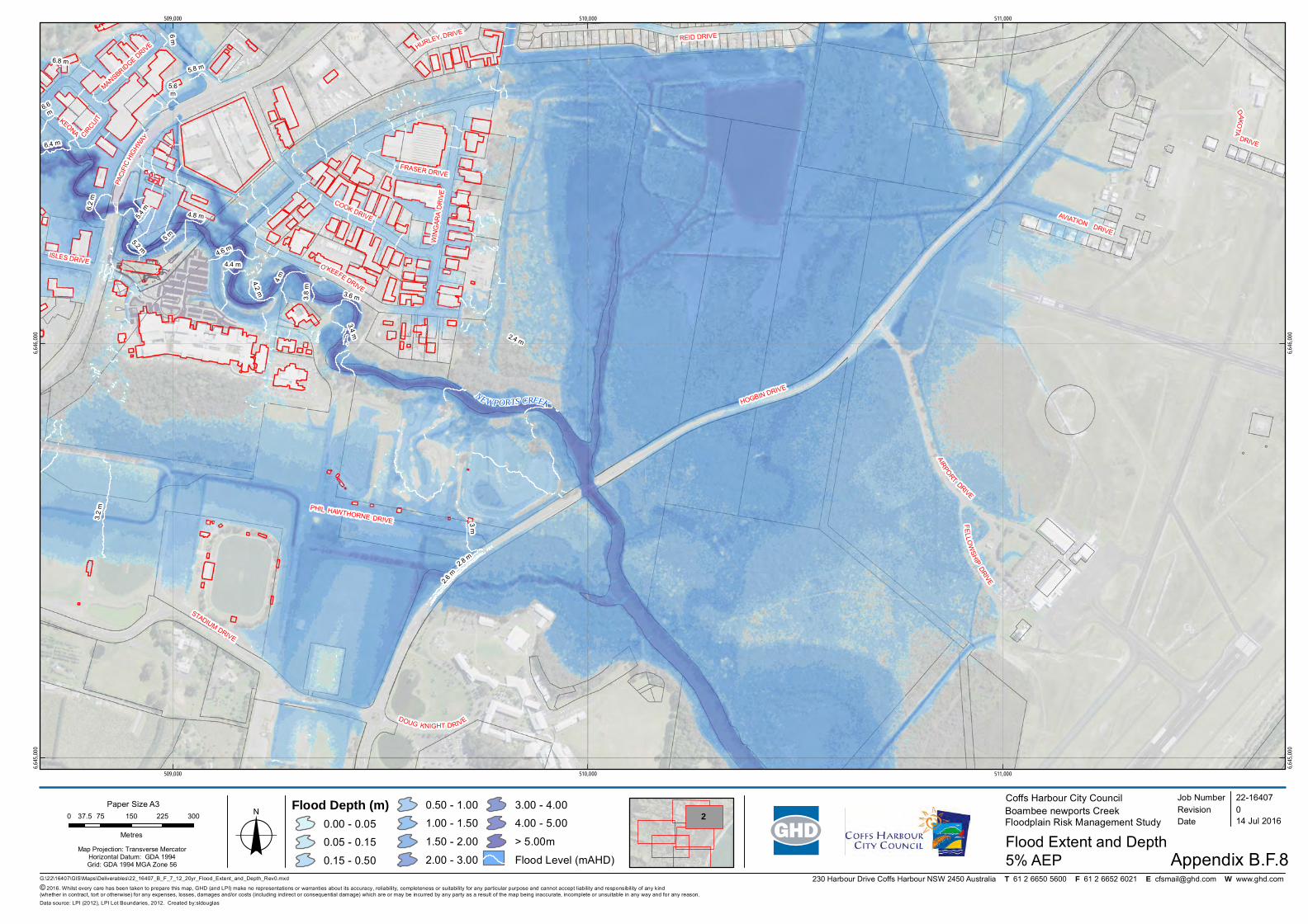
230 Harbour Drive Coffs Harbour NSW 2450 Australia T 61 2 6650 5600 F 61 2 6652 6021 E [email protected] W www.ghd.com
ISLES DRIVE
HURLEY DRIVE
MANSBRIDGE D
RIVE
DAKOTA
DRIVE
FELLO
WSH
IPDRIVE
WIN
GAR
A D
RIV
E
REID DRIVE
COOK DRIVE
PHIL HAWTHORNE DRIVE
STADIUM DRIVE
DOUG KNIGHT DRIVE
PACI
FIC
HIGHW
AY
AVIATION DRIVE
HOGBIN DRIVE
AIRPORT
DRIVE
KEONA CIRCUIT
FRASER DRIVE
O'KEEFE DRIVE
NEWPORTS CREEK
2.4 m
6.8 m
6 m
5.6m
3.8
m
5.8 m
4.4 m
6.6m
5 m
2.6 m
6.2
m
3.6 m
4.8 m
4.2 m
5.4 m
4 m
3.4 m
4.6 m
2.8 m
6.4 m
5.2 m
3.2
m
3 m
509,000
509,000
510,000
510,000
511,000
511,000
6,645,
000
6,645,
000
6,646,
000
6,646,
000
G:\22\16407\GIS\Maps\Deliverables\22_16407_B_F_7_12_20yr_Flood_Extent_and_Depth_Rev0.mxd
© 2016. Whilst every care has been taken to prepare this map, GHD (and LPI) make no representations or warranties about its accuracy, reliability, completeness or suitability for any particular purpose and cannot accept liability and responsibility of any kind (whether in contract, tort or otherwise) for any expenses, losses, damages and/or costs (including indirect or consequential damage) which are or may be incurred by any party as a result of the map being inaccurate, incomplete or unsuitable in any way and for any reason.
0 75 150 225 30037.5
Metres
Map Projection: Transverse MercatorHorizontal Datum: GDA 1994Grid: GDA 1994 MGA Zone 56
Coffs Harbour City CouncilBoambee newports CreekFloodplain Risk Management Study
Flood Extent and DepthAppendix B.F.8
Job NumberRevision 0
22-16407
14 Jul 2016
5% AEPo Date
Data source: LPI (2012), LPI Lot Boundaries, 2012. Created by:sldouglas
Paper Size A3
ClientLogo
2Flood Depth (m)
0.00 - 0.05
0.05 - 0.15
0.15 - 0.50
0.50 - 1.00
1.00 - 1.50
1.50 - 2.00
2.00 - 3.00
3.00 - 4.00
4.00 - 5.00
> 5.00m
Flood Level (mAHD)
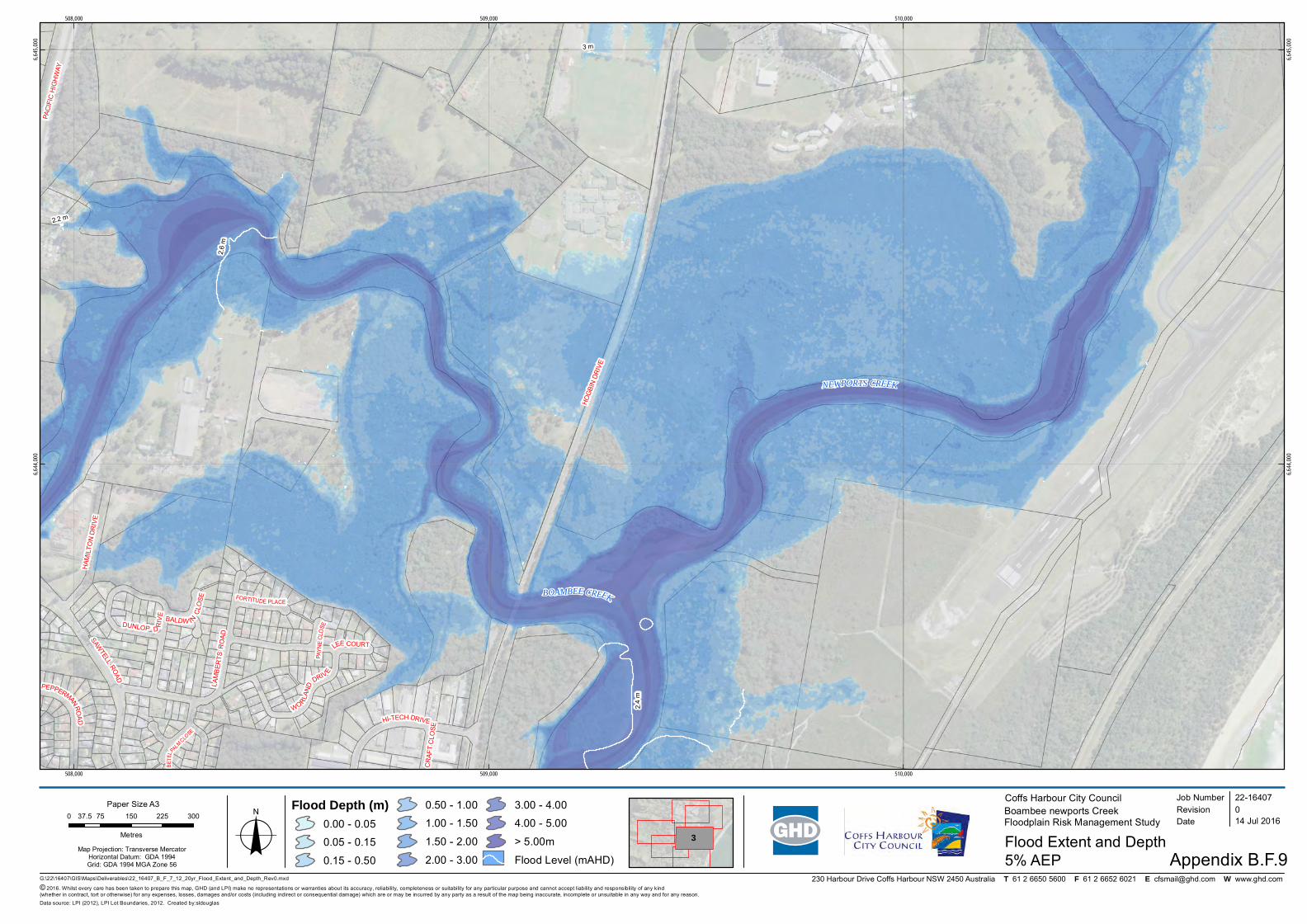
230 Harbour Drive Coffs Harbour NSW 2450 Australia T 61 2 6650 5600 F 61 2 6652 6021 E [email protected] W www.ghd.com
BALDW INC
LOSE
PAYN
EC
LOSE
LEE COURT
CR
AFT
CLO
SE
BETE
LPALMCLO
SE
FORTITUDE PLACE
HAM
ILTO
N D
RIV
E
PAC
IFIC
HIG
HW
AY
HI-TECH DRIVE
SAWTELL
ROAD
LAM
BER
TSR
OA
D
HO
GBI
N D
RIV
E
PEPPERMANRO
AD
DUNLOP D RIV
E
WORLA
ND
DRIV E
BOAMBEE CREEK
NEWPORTS CREEK
3 m
2.2 m2.
6 m
2.4
m
508,000
508,000
509,000
509,000
510,000
510,000
6,644,
000
6,644,
000
6,645,
000
6,645,
000
G:\22\16407\GIS\Maps\Deliverables\22_16407_B_F_7_12_20yr_Flood_Extent_and_Depth_Rev0.mxd
© 2016. Whilst every care has been taken to prepare this map, GHD (and LPI) make no representations or warranties about its accuracy, reliability, completeness or suitability for any particular purpose and cannot accept liability and responsibility of any kind (whether in contract, tort or otherwise) for any expenses, losses, damages and/or costs (including indirect or consequential damage) which are or may be incurred by any party as a result of the map being inaccurate, incomplete or unsuitable in any way and for any reason.
0 75 150 225 30037.5
Metres
Map Projection: Transverse MercatorHorizontal Datum: GDA 1994Grid: GDA 1994 MGA Zone 56
Coffs Harbour City CouncilBoambee newports CreekFloodplain Risk Management Study
Flood Extent and DepthAppendix B.F.9
Job NumberRevision 0
22-16407
14 Jul 2016
5% AEPo Date
Data source: LPI (2012), LPI Lot Boundaries, 2012. Created by:sldouglas
Paper Size A3
ClientLogo3
Flood Depth (m)0.00 - 0.05
0.05 - 0.15
0.15 - 0.50
0.50 - 1.00
1.00 - 1.50
1.50 - 2.00
2.00 - 3.00
3.00 - 4.00
4.00 - 5.00
> 5.00m
Flood Level (mAHD)
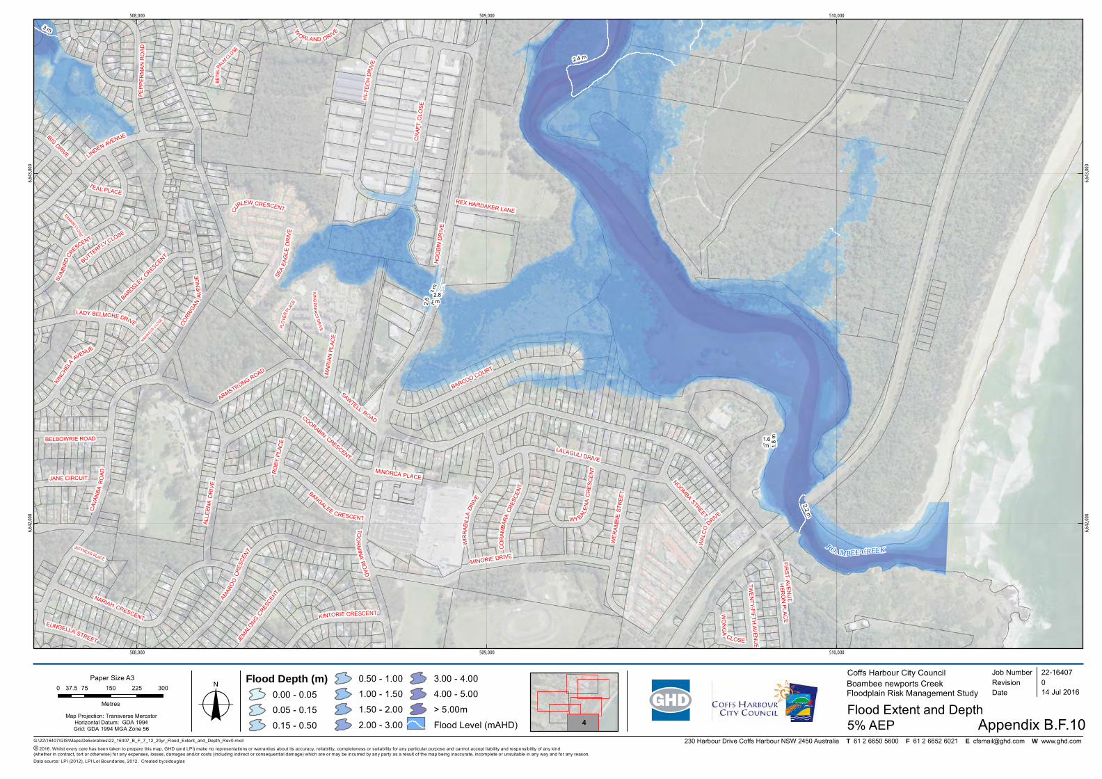
230 Harbour Drive Coffs Harbour NSW 2450 Australia T 61 2 6650 5600 F 61 2 6652 6021 E [email protected] W www.ghd.com
RANKIN CLOSE
MAKINSON C
LOSE
RO
BY P
LAC
E
TEAL PLACE
JEFFRESS PLACE
BETE
LP
ALMCLO
SE
MINORCA PLACE
W
O RLAND DRIVE
IBIS DRIVE
WAL
CO
DRIVE
WO
NG
A
CLOSE
MA
RIA
N P
LAC
E
EUNGELLA STREET
REX HARDAKER LANE
TWE
NTY-FIFTH
AVEN
UE
JANE CIRCUIT
BELBOWRIE ROAD
HER
ON
PLAC
EKINTORIE CRESCENT
BARDSLEY C
RESCENT
KINC
HELA
AVENUE
PEP
PER
MA
NR
OAD
FIRST AV
EN
UE
LADY BELMORE DRIVE CORR
IGAN
AVE
NU
E
JEMAL
ONG CRES
CENT
CR
AFT
CLO
SE
BANGALEE CRESCENT
LALAGULI DRIVE
COORABIN CRESCENT
BARCOO COURT
ARMSTRONG ROAD
LINDEN AVENUE
TOO
RM
INA
RO
AD
NARIAH CRESCENT
AMAR
OO
CR
ESCE
NT
MINORIE DRIVE
HO
GB
IN D
RIV
E
SAWTELL ROAD
KIN
GP A
RR
OT
DR
IVEPL
OVE
RPL
ACE
BUTTERFLYCLOSE
NOOMBA STREET
CU
RLEW CRESCENT
CO
RA
MBA
RA
CRES
CEN
T
WE
RA
MB
IE S
TREE
T
WIR
RA
BILL
ADR
IVE
WY BALE
NA
CR
ESC
EN
T
ALLE
ENA
DR
IVE
SUN
BIR
DCRE
SCENT
SEA
EA
GLE
DR
IVE
HI- T
ECH
DRIV
E
CAV
ANBA
RO
AD
BOAMBEE CREEK
3 m
1.8
m2
m
2.6
m3
m
2.2 m
2.4 m
1.6m
2.8m
508,000
508,000
509,000
509,000
510,000
510,000
6,642,
000
6,642,
000
6,643,
000
6,643,
000
G:\22\16407\GIS\Maps\Deliverables\22_16407_B_F_7_12_20yr_Flood_Extent_and_Depth_Rev0.mxd
© 2016. Whilst every care has been taken to prepare this map, GHD (and LPI) make no representations or warranties about its accuracy, reliability, completeness or suitability for any particular purpose and cannot accept liability and responsibility of any kind (whether in contract, tort or otherwise) for any expenses, losses, damages and/or costs (including indirect or consequential damage) which are or may be incurred by any party as a result of the map being inaccurate, incomplete or unsuitable in any way and for any reason.
0 75 150 225 30037.5
Metres
Map Projection: Transverse MercatorHorizontal Datum: GDA 1994Grid: GDA 1994 MGA Zone 56
Coffs Harbour City CouncilBoambee newports CreekFloodplain Risk Management Study
Flood Extent and DepthAppendix B.F.10
Job NumberRevision 0
22-16407
14 Jul 2016
5% AEPo Date
Data source: LPI (2012), LPI Lot Boundaries, 2012. Created by:sldouglas
Paper Size A3
ClientLogo
4
Flood Depth (m)0.00 - 0.05
0.05 - 0.15
0.15 - 0.50
0.50 - 1.00
1.00 - 1.50
1.50 - 2.00
2.00 - 3.00
3.00 - 4.00
4.00 - 5.00
> 5.00m
Flood Level (mAHD)