
Floodplain Risk Management Framework. Vision ... The Floodplain Risk Management Framework provides a...
35
Moreton Bay Regional Council Floodplain Risk Management Framework October 2015
Transcript of Floodplain Risk Management Framework. Vision ... The Floodplain Risk Management Framework provides a...
Moreton Bay Regional Council
Floodplain Risk Management Framework
October 2015
Document Control:
Revision Date Document Purpose Author(s)
0
October 2014 Initial external release to support planning scheme
Moreton Bay Regional Council
1.0 October 2015 Council adoption Moreton Bay Regional Council
Moreton Bay Regional Council - Floodplain Risk Management Framework
Page i
Table of Contents
1. Introduction ................................................................................................ 1
1.1. Background ................................................................................................. 1
1.2. Vision .......................................................................................................... 1
1.3. How to Use this Framework ........................................................................ 2
1.4. Previous Studies and Planning Decisions ................................................... 2
1.5. January 2011 Flood Event .......................................................................... 2
2. Floodplain Risk Management Concepts ..................................................... 3
2.1. Factors for Effective Floodplain Risk Management ...................................... 3
2.2. Best Practice Principles - Floodplain Risk Management .............................. 3
3. Legislative Imperative................................................................................. 6
3.1. Sustainable Planning Act 2009 .................................................................... 6
3.2. State Planning Policy July 2014 .................................................................. 7
3.3. Disaster Management Act 2003 (as amended to 2010) ............................... 8
3.4. Coastal Protection and Management Act .................................................... 9
3.5. Queensland Reconstruction Authority Act ................................................... 9
3.6. Queensland Floods Commission of Inquiry ............................................... 10
3.7. The Floodplain Risk Management Plan ..................................................... 10
4. Floodplain Risk Management Framework ................................................ 12
4.1. Framework Objectives ............................................................................... 12
4.2. Floodplain Risk Management Committee .................................................. 14
4.3. Attainment Levels ...................................................................................... 14
4.4. Step 1 - Identify the Flood Risk ................................................................. 14
4.5. Step 2 - Analyse the Flood Risk ................................................................ 15
4.6. Step 3 - Prepare a Floodplain Risk Management Plan .............................. 17
4.7. Step 4 - Implement the Floodplain Risk Management Plan ....................... 18
5. Roles & Responsibilities ........................................................................... 19
5.1. Commonwealth Government ..................................................................... 19
5.2. State Government ..................................................................................... 19
5.3. Local Government ..................................................................................... 21
5.4. Developers ................................................................................................ 22
5.5. The Flood Prone Community ..................................................................... 23
6. Glossary ................................................................................................... 24

Moreton Bay Regional Council - Floodplain Risk Management Framework
Page ii
Table Index
Table 4.1 Typical Floodplain Risk Management Measures ................................. 17 Table 6.1 Glossary of Terms .............................................................................. 24
Figure Index
Figure 3.1 Legislation and Floodplain Risk Management Process ...................... 11 Figure 4.1 MBRC Floodplain Risk Management Framework .............................. 13
Moreton Bay Regional Council - Floodplain Risk Management Framework
Page 1
1. Introduction
1.1. Background
Flooding is perhaps the most manageable of all natural hazards. There is typically more uncertainty about the onset of other events such as tropical cyclones, drought, earthquakes and bushfires.
It is relatively straightforward to determine how and why a flood occurs, and where it will happen. Flooding can be planned for, its effects can be mitigated and regulations can be put in place to address the residual problem remaining after mitigation. The parameters we do not know are mainly when, and how large, the flood will be.
There is a growing expectation within the community that State and Local Governments will be capable of managing natural hazards in an efficient and effective manner, which minimizes loss of life and property and ideally the avoidance of a potential disaster.
Significant areas of the Moreton Bay Regional Council MBRC area are subject to flooding including river and creek flooding, storm tide and overland flow.
It is within the above context that Council has determined to develop a strategic framework within which its floodplain risk management measures will be conceptualised, assessed and implemented.
This Floodplain Risk Management Framework is not currently a formal requirement of any State legislation; however this does not prevent Council from being pro-active in the implementation of relevant investigation and planning activities to inform formal flood planning and disaster management processes.
1.2. Vision
The vision for Council’s Framework is that:
“Floodplains in MBRC will be managed for the long-term benefit of the community such that hazards to people and damages to property and infrastructure are minimised and the intrinsic environmental values of the floodplain are protected”
This vision is developed from the vision contained in the Government’s State Planning Policy 1/03: Mitigating the Adverse Impacts of Flood, Bushfire and Landslide, published in 2003 as follows:
“The Queensland Government considers that development should minimise the potential adverse impacts of flood, bushfire and landslide on people, property, economic activity and the environment.”
Council’s vision should be followed using a value-based approach to the management of flood risk that balances social, economic, environmental and flood risk parameters to determine whether particular development or use of the floodplain is appropriate and sustainable. With this approach, the FRMF avoids the unnecessary alienation of flood prone land. It also ensures that flood prone land is not the subject of uncontrolled development, inconsistent with its exposure to flooding.
The Framework has been prepared in accordance with best practice to meet the following broad principles:
All levels of government and the local community know and accept their responsibilities for managing flood risk and all relevant agencies provide aid to the
Moreton Bay Regional Council - Floodplain Risk Management Framework
Page 2
community in recovering from the devastating impacts of flooding
Flood risk and flood behaviour is understood and considered in a strategic manner in the development decision-making process
Land use planning and development controls minimise both the exposure of people to flood hazard and the potential damages to property and infrastructure
A broad range of floodplain management measures are assessed across a broad range of floods up to the Probable Maximum Flood, and floodplain management measures appropriate to the location and acceptable to the local community economically, socially and environmentally are used to manage flood risk
All relevant agencies work in partnership to provide flood forecasting and warning systems and emergency response arrangements that cope with the impacts of flooding on the community in light of the available flood intelligence
1.3. How to Use this Framework
The Floodplain Risk Management Framework provides a guide to the development and implementation of Floodplain Risk Management Plans, developed to establish sound, long-term floodplain management outcomes that satisfy the social and economic needs of the community as well as being attuned with the natural ecosystems within the floodplain.
The Framework document describes:
Basic floodplain risk management concepts (Section 2)
The legislative imperative for floodplain risk management (Section 3)
The Floodplain Risk Management Framework itself (Section 4)
The roles and responsibilities of relevant stakeholders in implementing the Framework (Section 5)
The Framework is to be read and interpreted in a global sense with reference to the overall Framework objectives described in Section 4.1.1. This document is targeted at a strategic management level.
1.4. Previous Studies and Planning Decisions
The Framework introduced in this document aims to provide a consistency of approach across a significant local government area in South-east Queensland, leading to the achievement of the Vision outlined in Section 1.2 above. The establishment of this Framework does not negate the results of any previous flood studies and planning decisions undertaken by either MBRC or its predecessors. These studies and decisions are important tools in floodplain management within MBRC and will remain so until there is a need to revisit or upgrade the results and outcomes.
1.5. January 2011
While introducing this Framework it is important to reflect on one of the most significant flood events that has struck our region in the recent past. On Tuesday 11 January 2011, a heavy rain event resulted in approximately 400mm of rain falling over a 10 hour period. The heaviest rainfall occurred in a wide band stretching along the hinterland between Elimbah and Samford and west as far as Woodford. The resultant flooding caused considerable damage to both public and private infrastructure across numerous floodplain areas
Moreton Bay Regional Council - Floodplain Risk Management Framework
Page 3
downstream.
This event and similar experiences across Queensland focussed attention on the impacts of flooding and the way in which these can be managed. The Queensland Floods Commission of Inquiry and Queensland Reconstruction Authority were both established by the State Government as a result.
For Moreton Bay Regional Council, the impacts of this event have re-affirmed the importance of a pro-active and strategic response to the management of our floodplains. The successful implementation of this Framework will mean that our region and our community can improve its resilience and reduce impacts when further flooding is experienced in the future.
2. Floodplain Risk Management Concepts
It should be noted in all the discussion that follows, “floodplain” is defined as land that is subject to inundation by floods, regardless of source, up to and including the Probable Maximum Flood (PMF) event. This is synonymous with the term “flood prone land”.
2.1. Factors for Effective Floodplain Risk Management
Drawing on “Floodplain Risk Management in Australia: Best Practice Principles and Guidelines” (SCARM Report 73, 2000), the factors that contribute to effective floodplain management are:
An authority with the primary responsibility for floodplain management policy and practice
Appropriate and effective legislative powers for the responsible authority, with powers applied on a catchment-wide basis
Appropriate mechanisms for coordination of land use planning and floodplain management on a catchment-wide basis
A community awareness of the flooding problem and the planning/management process, and a willingness to become involved
Completion of flood studies and floodplain management studies overseen by a steering committee representing all interested or affected parties
Provision of adequate resources to undertake studies and implement measures
Access to technical advice, standards and guidelines for the authority responsible for floodplain management
Legal provisions ensuring that the responsible authority exercises its powers responsibly, such as legal liability for the consequences of decisions
Provision for intercession by a central authority when necessary
While some of these factors raise State- or Nation-wide issues in their application, many relate directly to the application of sound floodplain management by a Council or local government authority.
2.2. Best Practice Principles - Floodplain Risk Management
There are a number of best practice principles that should be pursued in effective floodplain
Moreton Bay Regional Council - Floodplain Risk Management Framework
Page 4
management as follows:
2.2.1. A Pro-Active Response
The fundamental best practice principle of floodplain management is the adoption of a pro-active response to the flood problem, a response that first recognises the various flooding problems and then moves to address these issues and problems before they develop to or are experienced at extreme levels.
It is this principle that is the driving force behind the development of the MBRC Floodplain Risk Management Framework.
2.2.2. Community Expectations
Floodplain management must strive to ensure that the community is:
Able to live and work on floodplains without risk to life and safety or unacceptable risk of damage to goods, possessions and infrastructure because of flooding;
Secure in the knowledge that effective arrangements are in place to alleviate the economic and social costs of flooding and foster recovery of the flooded area and its residents/occupants; and
Actively involved in the floodplain management process, both in the development of a Floodplain Risk Management Plan and in meeting their obligations under that plan.
2.2.3. Policy and Implementation
Effective policy and legislation are vital in providing a reliable social and legal foundation for floodplain management and thus it is essential that there is an integrated policy framework within all agencies that supports the management of floodplains and addresses the reduction of flood risk to life and property.
2.2.4. Recognize the three distinct types of Flood Problem
Current floodplain management practice recognises three distinct types of flood problems, described below:
The ‘existing’ problem refers to existing buildings and developments on flood prone land. Such buildings and developments, by virtue of their presence and location, are exposed to an “existing” risk of flooding.
The ‘future’ problem refers to buildings and developments that may be built on flood prone land in the future. Such buildings and developments may be exposed to a “future” flood risk, i.e. a risk that does not materialise until developments occur or that may result from climate change.
The ‘residual’ problem refers to the risk associated with floods generally and with those floods that exceed management measures already in place. That is, unless a floodplain management measure is designed to withstand the PMF, it will be exceeded by a sufficiently large flood at some time in the future. It is not a matter of if, but of when. Unless the Defined Flood Event (DFE) used for planning controls is based on the PMF, a larger flood than that used to determine the DFE can always occur. It is not a matter of if but when. The difference in flood levels, damages, and the area of inundation and the number of dwellings to be evacuated in the PMF event relative to the event upon which the DFE is based, serves to alert a council to the upper limit of the costs and consequences of
Moreton Bay Regional Council - Floodplain Risk Management Framework
Page 5
flooding.
2.2.5. Risk Appreciation
Best practice principles to foster the community’s appreciation of flood risk, exposure to flood hazard and appropriate responses include:
Documentation of flood risk by relevant agencies in an easily understood manner on flood maps, flood searches and fact sheets to enable individuals and the community to assess flood risk.
On-going community education by all relevant agencies in conjunction with emergency management agencies through a co-ordinated community education plan.
2.2.6. The Floodplain Risk Management Plan
The implementation of a comprehensive investigative and planning process that develops a Floodplain Risk Management Plan is the most effective and equitable way to realise the multiple objectives of floodplain management.
2.2.7. The Flood Emergency Plan
Preparation of a flood emergency plan encompassing flood preparedness, prevention, response and recovery arrangements is the most effective way to address the residual flood risks associated with flood events.
It should be noted that flood warning should be an integral part of the flood response arrangements.
2.2.8. Appropriate Land Uses
The careful matching of land use to flood hazard both maximises the benefits of using the floodplain and minimises the risks and consequences of flooding.
2.2.9. Flood Maps
Flood maps that show the extent, depth and hazard of flooding for nominated flood events are an important tool for the preparation of Floodplain Risk Management Plans and flood emergency plans.
However, there needs to be:
Recognition that flood maps are necessarily inexact.
Considerable care taken with the depiction and explanation of flooding features so that the map is easily understood by the local community and is not subject to misleading interpretation.
The land use planning controls that flow from flood maps should be incorporated into statutory planning instruments in a timely and expeditious manner.
2.2.10. Floodplain Risk Management Measures
There are three generally recognised ways of managing floodplains to reduce flood losses:
By modifying the behaviour of the flood itself (Flood Modification);
By modifying or removing existing properties and/or by imposing controls on
Moreton Bay Regional Council - Floodplain Risk Management Framework
Page 6
property and infrastructure development (Property Modification); and
By modifying the response of the population at risk to better cope with a flood event (Response Modification).
Floodplain management measures should not be considered in isolation. Rather, they must be considered collectively on a risk management basis that allows their interactions, their suitability and effectiveness, and their social, ecological and economic impacts to be assessed on a catchment-wide, cumulative basis.
2.2.11. Flood Behaviour
An understanding of flooding behaviour, i.e. flood discharges, flood levels, flood velocities, duration of flooding, rate of rise of floodwaters, etc. is fundamental to the preparation of effective floodplain management and flood emergency plans. It must be recognised that the behaviour of each flood will have a unique combination of these parameters and none are likely to behave across all parameters in the way predicted by design flood events used in flood models. For example, several real floods and a design flood may all have the same peak but are likely to have different rates of rise and durations.
2.2.12. Performance Indicators and Data Collection
Flood behaviour, damage and other data should be collected expeditiously after an actual flood event has occurred, allowing an evaluation of the flood modelling and the effectiveness of floodplain management measures. Simultaneously, flood emergency operations should be reviewed in consultation with communities and, where necessary, modified.
3. Legislative Imperative
There are number of significant pieces of legislation that support the establishment of a Floodplain Risk Management Framework within Council’s area of responsibility. These Acts of Parliament are:
The Sustainable Planning Act (2009); and
The Disaster Management Act 2003 (as amended to 2010).
Coastal Protection and Management Act (1995 as amended to 2010)
Queensland Reconstruction Authority Act 2011
Much of this legislation is currently under review. The following discussion therefore needs to be read in the context of the potentially dynamic nature of flood related legislation at this time.
3.1. Sustainable Planning Act 2009
The Sustainable Planning Act (2009) (SPA) replaced the Integrated Planning Act (IPA) – the currently published guidelines on the application of the Act are based on the IPA and are in the process of review. However, as the Acts have the same objectives and purposes, the guidelines remain relevant to the current situation.
The Purpose of the Act is “to seek to achieve ecological sustainability by:
(a) managing the process by which development takes place, including ensuring the
Moreton Bay Regional Council - Floodplain Risk Management Framework
Page 7
process is accountable, effective and efficient and delivers sustainable outcomes; and
(b) managing the effects of development on the environment, including managing the use of premises; and
(c) continuing the coordination and integration of planning at the local, regional and State levels.”
Note that under this Act, Ecological sustainability is defined as “a balance that integrates—
(a) protection of ecological processes and natural systems at local, regional, State and wider levels; and
(b) economic development; and (c) maintenance of the cultural, economic, physical and social wellbeing of people and
communities.”
To achieve the requirements of the Act, local government is required to prepare Planning Documents that identify areas of natural hazard, which includes flooding from all sources, so that its development decision making process:
is accountable, coordinated, effective and efficient; and
takes account of short and long-term environmental effects of development at local, regional, State and wider levels, including, for example, the effects of development on climate change; and
applies the precautionary principle; and
seeks to provide for equity between present and future generations; and
ensures the sustainable use of renewable natural resources and the prudent use of non-renewable natural resources by, for example, considering alternatives to the use of non-renewable natural resources; and
avoids, if practicable, or otherwise lessening, adverse environmental effects of development, including, for example climate change and urban congestion; and adverse effects on human health.
3.2. State Planning Policy July 2014
The State Planning Policy July 2014 (SPP) provides a comprehensive set of principles to ensure all state interests in land use planning and development are incorporated into planning schemes and the development assessment system.
State Interest – natural hazards, risk and resilience, seeks for the “risks associated with natural hazards are avoided or mitigated to protect people and property and enhance the community’s resilience to natural hazards”.
The associated “Natural hazards risk and resilience” state interest guidelines and technical manual outlines the fit-for-purpose assessment of flood hazard risk to deliver the policy outcomes of:
Identifying natural hazard areas for flood, bushfire, landslide and coastal hazards based on a fit for purpose natural hazard study
Including provisions that seek to achieve an acceptable or tolerable level of risk based on a fit for purpose risk assessment consistent with AS/NZS ISO 31000:2009 Risk Management.
Including provisions that require development to: o avoid natural hazard areas or mitigate the risks of the natural hazard to an
Moreton Bay Regional Council - Floodplain Risk Management Framework
Page 8
acceptable or tolerable level, and o support, and not unduly burden, disaster management response or recovery
capacity and capabilities, and o directly, indirectly and cumulatively avoid an increase in the severity of the
natural hazard and the potential for damage on the site or to other properties, and
o maintain or enhance natural processes and the protective function of landforms and vegetation that can mitigate risks associated with the natural hazard.
Facilitating the location and design of community infrastructure to maintain the required level of functionality during and immediately after a natural hazard event.
3.3. Disaster Management Act 2003 (as amended to 2010)
The Disaster Management Act 2003 (DMA) forms the legislative basis for disaster management arrangements for Queensland including:
establishing disaster management groups for the State, Disaster Districts and Local Government areas;
detailing planning requirements at each level;
maintaining the role and operations of the State Emergency Service (SES) and establishment of Emergency Service Units (ESUs); and
providing for the conferring of powers on selected individuals and groups.
The main objectives of the DMA are:
To help communities mitigate the potential adverse effects of an event; and prepare for managing the effects of an event; and to effectively respond to and recover from a disaster or an emergency situation.
To provide for effective disaster management for the state,
To establish a framework for the management of the SES to ensure the effective performance of their functions.
The Objects of the current DMA have been amended to include reference to the following principles of disaster management (inter alia):
effective disaster management requires planning across all four phases of disaster management: prevention, preparation, response and recovery;
that all hazards, whether natural or caused by humans, should be managed using a disaster management framework;
that it is primarily local governments that are responsible for managing disasters in their local government area and that district and state groups should provide local governments with appropriate resources and support to be able to manage disaster operations.
The functions of a local government under the DMA are to:
ensure it has a disaster response capability (as outlined under s80 (2) of the DMA);
approve its local disaster management plan prepared under part 3 of the DMA;
Moreton Bay Regional Council - Floodplain Risk Management Framework
Page 9
ensure information about an event or a disaster in its area is promptly given to the District Disaster Coordinator (DDC) for the Disaster District in which its area is situated;
perform other functions given to the local government under this Act.
Local government is best situated to provide first-hand knowledge and understanding of social, economic, infrastructure and environmental issues within their respective communities and are ideally placed to support its community from a disaster management perspective. This is achieved through the Local Disaster Management Group (LDMG) where Local Governments coordinate their response to a disaster.
Section 57 (1) of the Disaster Management Act 2003 requires local governments to develop a local disaster management plan (LDMP) as a part of their response capability for disaster management in their area. Section 57 (2)(f) further requires that the LDMP must address matters stated in the disaster management guidelines and Section 58 states that the LDMP must be consistent with the disaster management guidelines.
Section 63 (1) gives authority to the Chief Executive of the Department to prepare guidelines to inform State, District and Local Groups about the preparation of plans and matters to be included in plans.
3.4. Coastal Protection and Management Act
The Coastal Protection and Management Act (CPMA) form the legislative basis for coastal management within Queensland. One of the main objectives of the CPMA is to “ensure decisions about land use and development safeguard life and property from the threat of coastal hazards”.
While the operation of the Queensland Coastal Plan was suspended on 8 October 2012, the State Policy for Coastal Management is still in effect. Relevant principles of the State Policy for Coastal Management include:
Natural coastal processes including erosion and accretion are able to occur without interruption
Structures (including all infrastructure) in erosion prone areas are designed, located and managed to ensure that impacts on coastal processes are avoided or minimised.
Buildings and structures (including all infrastructure) are established on State coastal land only where they are essential, provide a public service, and cannot be feasibly located elsewhere.
Management and use of coastal land is guided by plans of management.
3.5. Queensland Reconstruction Authority Act
The Queensland Reconstruction Authority Act (QRAA) provides for the effective and efficient recovery of State of Queensland and its communities from the impacts of disaster events. The definition of disaster for the purposes of the QRAA is taken to be that contained in the Disaster Management Act 2003.
The QRAA enables the establishment of the Queensland Reconstruction Authority (the Authority). The main function of the Authority’s CEO is to “ensure proper planning, preparation, coordination and control of development for the protection, rebuilding and recover of affected communities”. Section 112 gives the Minister power to direct a local government to take action about local planning instruments.
Moreton Bay Regional Council - Floodplain Risk Management Framework
Page 10
3.6. Queensland Floods Commission of Inquiry
While the recommendations of the Queensland Floods Commission of Inquiry are not legislative in nature, it is expected that the Queensland State Government will put into effect these recommendations through changes to planning legislation. Of particular relevance to this Framework is Recommendations 2.12 which states:
“Councils in floodplain areas should, resources allowing, develop comprehensive floodplain management plans that accord as closely as practicable with best practice principles”
3.7. The Floodplain Risk Management Plan
Although a Floodplain Risk Management Plan is not a formal requirement of either the Sustainable Planning Act (2009) or the Disaster Management Act (2003), this does not prevent local government from implementing investigation and planning activities which will inform formal flood planning and disaster management processes and documenting a process for conducting these activities in the form of a framework.
There is a growing expectation within the community that state and local governments will be capable of managing natural disasters in an efficient and effective manner, which minimizes loss of life and property.
It is within the context of the Legislative requirements above and the community expectations that Council is developing its Floodplain Risk Management Framework as a pre-cursor to development of a Floodplain Risk Management Plan.
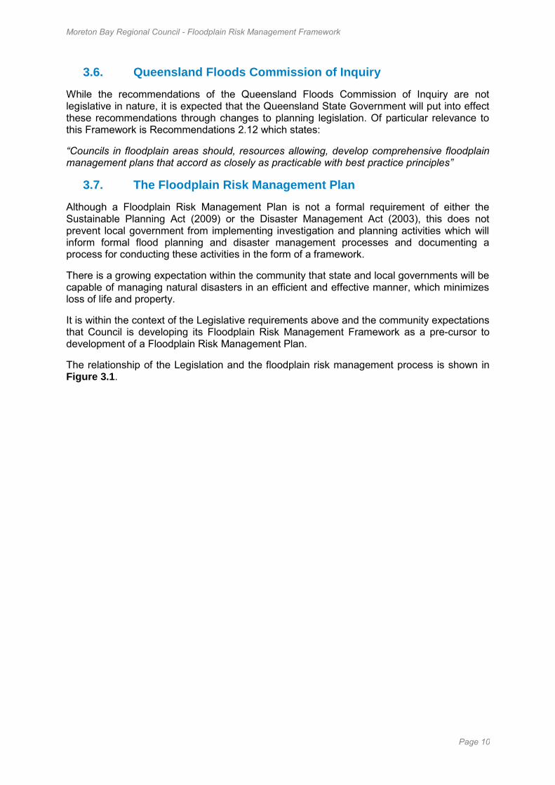
The relationship of the Legislation and the floodplain risk management process is shown in Figure 3.1.
Moreton Bay Regional Council - Floodplain Risk Management Framework
Page 11
Figure 3.1 Legislation and Floodplain Risk Management Process
Sustainable Planning Act Disaster Management Act
Floodplain Risk Management Framework
Flood Study
Floodplain Risk Management Study
Floodplain Risk Management Plan
Local Government prepares planning documents that identify areas of natural hazard (including
flooding)
Primarily Local Government that is responsible for managing disasters
in its local government area
State Planning Policy (July 2014) Natural hazard management areas
should be identified through a comprehensive and detailed natural hazard assessment
Local Governments to develop a local disaster management plan
(LDMP) and address matters stated in the disaster management
guidelines
Local Government adopts provisions (including a defined
flood event) for managing development
Natural hazard management areas (flood) determined through comprehensive floodplain
management study
Natural hazard management areas (flood) ideally should be
determined through comprehensive hazard/risk study

Moreton Bay Regional Council - Floodplain Risk Management Framework
Page 12
4. Floodplain Risk Management Framework
4.1. Framework Objectives
The objectives of the Framework are:
To ensure that all levels of government and the local community are aware of their responsibilities for managing flood risk.
To ensure floodplain management functions are integrated within a broader sustainable land management framework.
To ensure that flood risk and flood behaviour is understood and considered in a strategic manner in the decision-making process and that land use is consistent with flood risk and potential damages.
To ensure land use planning and development controls minimise both the exposure of people to flood hazard and damage costs to property and infrastructure.
To ensure a broad range of floodplain management measures (both structural and non-structural) are considered and flood mitigation measures appropriate to the location and acceptable to the local community are used to manage flood risk where economically, socially and environmentally viable.
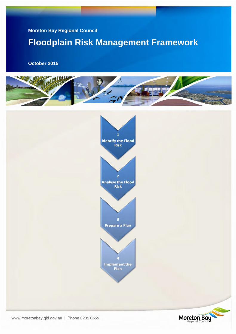
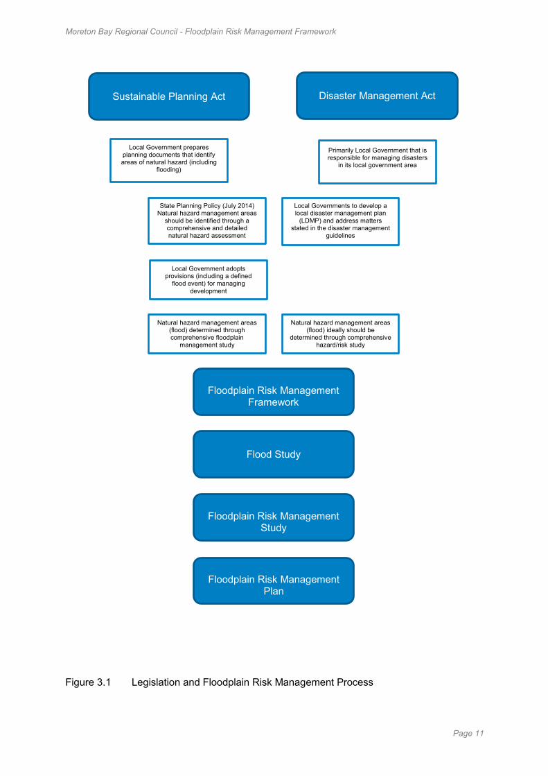
The formulation and implementation of a Floodplain Risk Management Plan describing a course of action to address the above objectives is a cornerstone of the Framework. The development and implementation of a Floodplain Risk Management Plan is achieved through the application of a four step process described in Figure 4.1 below.
This Framework is generally addressed to the management of floods arising from heavy rainfall (river & creek flooding), storm tide, and urban flash flooding (overland flowpaths). The special circumstances relating to unusually high tides (e.g. so-called “king” tides), tsunami, local ponding from heavy rainfall and dam failure are outside the reach of the Framework however the general principles may apply when Council is ready to pursue strategic planning for these forms of flooding.
Moreton Bay Regional Council - Floodplain Risk Management Framework
Page 13
Figure 4.1 MBRC Floodplain Risk Management Framework
1
Identify the Flood Risk
•Investigate and describe flood behaviour for a range of probabilities
•Identify the flood impact area
•Document outcome in the form of a Flood Study
•Refer Section 4.4 for details
2
Analyse the Flood Risk
•Analyse consequence and risk using objective criteria
•Confirm the greatest risks and range of available risk treatment measures
•Document outcome in the form of a Floodplain Risk Management Study
•Refer Section 4.5 for details
3
Prepare a Plan
•Short-list, prioritise and adopt appropriate risk treatment measures
•Prepare an implementation strategy including roles and responsibilities
•Document outcome in the form of a Floodplain Risk Management Plan
•Refer Section 4.6 for details
4
Implement the Plan
•Implementation of the Floodplain Risk Management Plan
•Regular monitoring and review of the plan
•Refer Section 4.7 for details
Moreton Bay Regional Council - Floodplain Risk Management Framework
Page 14
4.2. Floodplain Risk Management Committee
During the application of the Framework the formation of a Floodplain Risk Management Committee (the Committee) is recommended. The committee can be a technical steering group, a separate entity or part of an existing committee such as the Local Disaster Management Group (LDMG), however the LDMG must be focused on flooding issues when operating as a Floodplain Risk Management Committee.
It would generally be chaired by Council however special arrangements would be needed if studies and plans require co-ordination with adjoining local government areas.
Responsibility for planning matters lies with the Council as a whole and as the Committee is advisory in nature, it should report directly to Council. Its principal objective is to assist council in the development and implementation of one or more Floodplain Risk Management Plans for its service area. The Committee is both the focus of, and a forum for, the discussion of technical, social, economic and ecological issues and for the distillation of possibly differing viewpoints on these issues.
Once the Committee has completed the primary task of developing the Floodplain Risk Management Plan including its implementation strategy, and council has adopted these, it is suggested that a limited group remain to oversee implementation.
4.3. Attainment Levels
The Framework recognizes two levels of attainment for each step in the procedure:
Basic – the level of detail achieved supports a basic understanding of the risks and the management measures that are available for their treatment. One of the recommended measures of a basic Floodplain Risk Management Plan should be progression towards an advanced level of attainment for the entire region or, as a minimum, those floodplain precincts where risks are considered likely to be greatest. A basic plan may be completed in the absence of a formal Floodplain Risk Management Committee, generally only deals with existing risk (not future risk) and does not require hydrologic and hydraulic modelling.
Advanced – the level of detail achieved supports a detailed understanding of the risks and management measures that are available for their treatment including detailed evaluation and prioritisation of measures and clear recommendations for their implementation. Advanced planning should not be undertaken in the absence of supervision by a Floodplain Risk Management Committee.
4.4. Step 1 - Identify the Flood Risk
Identifying flood risk first requires the collection of a variety of data to assess flood behaviour and the effectiveness, costs and benefits of management measures. It is important to define the data currently available and that needed for the study, to identify information gaps. The Floodplain Risk Management Committee should initiate studies, where gaps exist, to collect the social, economic, flooding, ecological, land use, cultural, and emergency management data required in management studies. Where relevant data exists this should be collated and referred to in investigations.
Data collection is not an end in itself; it is input to enable preparation of properly informed studies, management plans and floodplain management decisions associated with each type of flood affectation. There are three major types of flooding within the Moreton Bay Region requiring investigation:
River and Creek Flooding
Moreton Bay Regional Council - Floodplain Risk Management Framework
Page 15
Storm Tide (tropical cyclone or east coast low)
Overland Flow
Other forms of flooding (not specifically addressed by the Framework) include unusually high tides (e.g. so-called “king” tides), tsunami, local ponding from heavy rainfall and dam failure.
A flood study is a comprehensive technical investigation of flood behaviour. It defines the nature of flood risk by providing information on the extent, level and velocity of floodwaters and on the distribution of flood flows across various sections of the floodplain for the full range of flood events up to and including the PMF.
Flood studies are necessary because detailed knowledge of flood characteristics is required to deal with existing problems, future development and the residual flood risk. Major components of a flood study involve determining discharge (hydrologic aspects) and water levels, velocities, etc (hydraulic aspects) for floods of varying severity. Council has determined that WBNM is the preferred method for hydrologic studies and that the numerical modelling system TUFLOW is to be used for investigating the hydraulic aspects of the floodplain.
The flood study also determines hydraulic and hazard categories within the floodplain for the potential range of floods and land use scenarios in order to consider cumulative effects. The FRMF recognises three hydraulic categories (floodways, flood storage and flood fringe) and five hazard categories.
Investigating the full range of flood events up to and including the PMF enables changes in the nature and consequences of flooding to be assessed as flood severity increases. These may include increases in velocity and depth, changes in hazard category, the creation of ‘islands’ (which may be completely inundated in larger events), and the number of properties inundated etc.
Determining appropriate areas for different types of development generally depends upon flood exposure of the land, as defined by hydraulic and hazard categorisation. This information is also weighed objectively in selecting Defined Flood Events.
Finally, climate change may affect the weather events that cause flooding, sea levels may continue to rise and the pattern of flood producing storms may change significantly in terms of both frequency of event and intensity. Their potential impacts need to be considered when identifying the flood risk.
4.5. Step 2 - Analyse the Flood Risk
Once Step 1 is completed a Floodplain Risk Management Study is to be prepared to objectively analyse the risks associated with flooding and to identify, assess and compare various flood management options.
The Floodplain Risk Management Study draws together the results of the flood study and data collection exercises. It provides information and tools to allow strategic assessment of the impacts of management options for existing, future and residual flood risk on flood behaviour and hazard and the social, economic, ecological and cultural costs and benefits of options. It also provides the basis for robust decision making in the management plan.
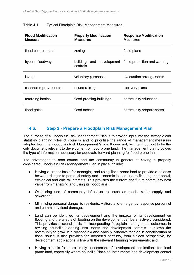
The suite of flood management measures that a management study will propose generally involves a mix of options as it is unusual for a single management option to manage the full range of flood risk. Determining the optimum mix of measures can require complex studies, exercise of professional judgement and extensive community consultation. Typical options considered are indicated in Table 4.1 and should include:
Moreton Bay Regional Council - Floodplain Risk Management Framework
Page 16
property modification measures including development controls in new areas, and voluntary purchase and house raising in developed areas;
response modification measures such as evacuation and associated operational logistics; and
flood modification measures including levees and bypass channels
The impact of management works or proposed developments on flooding behaviour elsewhere should be assessed on a cumulative rather than individual or ad-hoc basis within the context of the management plan. This includes both the effect of development on flood behaviour and the number of people who may require evacuation, particularly in rare flood events. Where mitigation works are considered, they should be designed to produce net positive ecological outcomes, where practical and feasible. Mitigation works should also consider potential changes to the weather events that cause flooding. Accordingly the design life of projects must be subject to close scrutiny so as to avoid costly upgrading or redesign of adopted measures.
Moreton Bay Regional Council - Floodplain Risk Management Framework
Page 17
Table 4.1 Typical Floodplain Risk Management Measures
Flood Modification Measures
Property Modification Measures
Response Modification Measures
flood control dams zoning flood plans
bypass floodways building and development controls
flood prediction and warning
levees voluntary purchase evacuation arrangements
channel improvements house raising recovery plans
retarding basins flood proofing buildings community education
flood gates flood access community preparedness
4.6. Step 3 - Prepare a Floodplain Risk Management Plan
The purpose of a Floodplain Risk Management Plan is to provide input into the strategic and statutory planning roles of councils and to prioritise the range of management measures adopted from the Floodplain Risk Management Study. It does not, by intent, purport to be the only document relevant to development of flood prone land. The management plan provides the type of information necessary for adequate forward planning for flood prone land.
The advantages to both council and the community in general of having a properly considered Floodplain Risk Management Plan in place include:
Having a proper basis for managing and using flood prone land to provide a balance between danger to personal safety and economic losses due to flooding, and social, ecological and cultural interests. This provides the current and future community best value from managing and using its floodplains;
Optimising use of community infrastructure, such as roads, water supply and sewerage;
Minimising personal danger to residents, visitors and emergency response personnel and community flood damage;
Land can be identified for development and the impacts of its development on flooding and the affects of flooding on the development can be effectively considered. This provides a sound basis for incorporating floodplain management outcomes in revising council’s planning instruments and development controls. It allows the community to grow in a responsible and socially cohesive fashion in consideration of flood issues. It also provides for increased certainty, from a flood perspective, for development applications in line with the relevant Planning requirements; and
Having a basis for more timely assessment of development applications for flood prone land, especially where council’s Planning Instruments and development control
Moreton Bay Regional Council - Floodplain Risk Management Framework
Page 18
plans and/or policies have been altered, in light of the management plan, to incorporate appropriate zonings, and flood related controls. Individual development applications are thus limited to the best way to achieve the required outcomes on individual sites.
Review of management plans should be triggered by the following instances:
Elapsed time - review regularly, around every 10 years, down to 5 if a flood has occurred in the meantime
After significant flood events which provide additional data on flood behaviour
Where significant changes occur to the factors influencing the decisions in the plan, including changes to local flood plans
Where impediments to implementation exist that warrant a review
Where changes in future land use trends outside those considered in the management plan are proposed
This review should account for changes across the full range of issues originally addressed and consider any associated emergent issues.
4.7. Step 4 - Implement the Floodplain Risk Management Plan
Once a Floodplain Risk Management Plan has been adopted, it needs to be implemented. Certain components can be implemented relatively quickly, such as incorporating flood related development controls into policy and Planning Instruments and flood education programs. Others require additional investigations and design, and funding.
It is unlikely that any management plan could be implemented immediately in its entirety. For example, availability of funding will determine when mitigation works can commence. Consequently, an implementation strategy is required to stage components dependent on funding availability and the management plan needs to consider adoption of interim measures. The implementation strategy should be developed during the preparation of the management plan and incorporated in the plan.
Moreton Bay Regional Council - Floodplain Risk Management Framework
Page 19
5. Roles & Responsibilities
The primary responsibility for the application of sound floodplain management rests with local government. However, all levels of Government can contribute to or have partial responsibility for floodplain management.
5.1. Commonwealth Government
The Commonwealth Government has a general responsibility for the economic and social well being of the nation. To this end, the Commonwealth Government currently:
Encourages the development of effective long-term strategies for the sustainable management of the nation's floodplains;
Provides flood forecasting services by the Bureau of Meteorology; Supports the development of emergency management capabilities through the
activities of Emergency Management Australia; and Provides financial assistance under the Natural Disaster Relief & Recovery
Arrangement (NDRRA), which is administered by the Department of Finance in conjunction with State and Territory Treasury Departments when flood damage and disruption is greater than a pre-set amount.
5.2. State Government
The roles of each State Government Agency are summarised below. The principal floodplain management role of State and Territory Governments has been stated as follows (DPIE, 1992):
"....to develop appropriate standards and strategic approaches for floodplain management and to ensure that they are applied in a coordinated and integrated fashion across the State. This role encompasses the provision of expert technical support via a principal water resources authority(s), of planning advice through a state planning agency and of effective counter disaster and welfare services".
5.2.1. Department of Environment and Heritage Protection
The Department of Environment and Heritage Protection (DEHP) is responsible for administering the Coastal Protection and Management Act 1995. DEHP provides a framework for how communities and environment can adapt to climate change impacts with a key focus on how coastal communities can better prepare for projected sea level rise, storm tide and erosion risks.
5.2.2. Department of State Development Infrastructure and Planning
The Department of State Development Infrastructure and Planning (DSDIP) is responsible for administering the Sustainable Planning Act 2009. DEDIP undertakes regional and statewide planning and establishes legislation and codes relating to planning and development.
5.2.3. Department of Natural Resources and Mines
The Department of Natural Resources and Mines (DNRM) is responsible for the sustainable management of water resources and catchment management. DNRM is also responsible for the monitoring of the flow and height of rivers and streams.
5.2.4. Department of Local Government
The Department of Local Government (DLG) is responsible for ensuring the Local
Moreton Bay Regional Council - Floodplain Risk Management Framework
Page 20
Governments of Queensland are strong, sustainable and resilient. DLG works with Local Government to undertake community planning, asset management and financial management.
5.2.5. Department of Community Safety (Emergency Management Queensland)
The Department of Community Safety (DCS) is responsible for the administration of the Disaster Management Act 2003. DCS provide disaster awareness and hazard reduction services through community safety and education programs and are the lead agency for the co-ordination of activities undertaken before, during and after a disaster or emergency to minimise adverse community impacts.
5.2.6. Department of Transport and Main Roads
The Department of Transport and Main Roads (DTMR) is responsible for providing a safe and efficient road network that deals with flood impacts by minimising the flood risk to the travelling public, and restoring relevant flood affected infrastructure. DTMR is also responsible for predicting road closures/re-openings and possible failure modes, if any.
5.2.7. Department of Communities, Child Safety and Disability Services
The Department of Communities, Child Safety and Disability Services in the lead agency for human recovery services (coordination, emergency accommodation, food and clothing, financial support) following an event.
5.2.8. Department of Energy and Water Supply
The Department of Energy and Water Supply (DEWS) is responsible for the bulk water and distributor-retailers as well as the operation and management of referable dams. DEWS is also responsible for the review and implementation of the Queensland Urban Drainage Manual.
5.2.9. Queensland Reconstruction Authority
The Queensland Reconstruction Authority (QRA) is responsible for administering the Queensland Reconstruction Authority Act 2011 and is the lead agency for the delivery of the Queensland Flood Commission of Inquiry recommendations relating to Floodplain management.
5.2.10. Obligations of State Government Agencies
It is a fundamental best practice principle of floodplain management that government agencies, be they Local, State or Commonwealth, are bound by the best practice principles of the FRMF.
Government agencies, whether State or Commonwealth, undertaking works or developments on flood prone land must comply with the provisions of Floodplain Risk Management Plans. When planning such works or developments, it is essential that the agency takes into account the nature and extent of the flood problem, the impact of the development on flood behaviour, and the impact of flooding on likely hazard levels at the development site.
If the proposed development is or could form part of infrastructure required for flood emergency management, e.g. a police station, hospital, telephone exchange or school, consideration should be given to relocating the development at a flood-free site (if possible), or ensuring that the proposed development can meet its intended emergency use when a flood eventuates.
Moreton Bay Regional Council - Floodplain Risk Management Framework
Page 21
Government agencies should seek the advice of local government with respect to flood behaviour, EMQ with respect to flood emergency procedures, Department of Infrastructure and Planning, as well as Council, in relation to planning considerations and the natural resource and environmental protection agencies in relation to environmental matters.
5.3. Local Government
Local government has a number of roles and responsibilities in the effective management of the floodplain. The principal roles and responsibilities are detailed below.
5.3.1. Prepare and Maintain Flood Models and Mapping
Flood models and associated studies provide important data for local government to understand the likelihood, extent and consequences associated with a range of flood events within the local government area. They also provide the foundation for raising public awareness of flood risks through flood mapping and information necessary for floodplain management decision making.
Flood models and mapping is most appropriately prepared by local government since local government holds much of the local knowledge and spatial data necessary for preparation of reliable flood models and maps.
As part of this responsibility local government should also put into place appropriate flood information management systems to ensure the information is managed and kept up to date.
5.3.2. Preparation of Floodplain Risk Management Plans
Flood prone land needs to be managed in accordance with its flood risk. This is achieved through the preparation and implementation of a Floodplain Risk Management Plan, which also considers the social, environmental and economic costs and benefits of the use and management of flood prone land. As part of this process, the council requires sound information concerning flood behaviour, flood impacts and the other planning factors that affect the use of flood prone land.
The preparation of a Floodplain Risk Management Plan is most effectively undertaken within the process described in the Framework, involving the compilation of a flood study and a floodplain risk management study prior to defining a Floodplain Risk Management Plan. The floodplain risk management process should involve comprehensive community consultation and public exhibition of the Floodplain Risk Management Plan to facilitate community understanding and acceptance of the proposals.
5.3.3. Planning Schemes
Local government should incorporate the planning provisions of Floodplain Risk Management Plans into statutory planning instruments.
5.3.4. Flood Emergency Plans
The preparation of a local flood emergency plan is the responsibility of local government as well as the provision of manpower, equipment and facilities to assist in flood response activities.
For the local flood emergency plan to be effective, local government needs to work in concert with EMQ to promote flood awareness in the community by supplying flood data and advice to property owners, residents, visitors, potential purchasers and
Moreton Bay Regional Council - Floodplain Risk Management Framework
Page 22
investors. In recognition of the turnover in residents, and human fallibility, such information should be provided on a regular basis.
5.3.5. Implementation and Review of Management Strategies
Once a Floodplain Risk Management Plan has been adopted, local government is responsible for the administration of many of the provisions of the plan, including:
The investigation, design, construction and maintenance of structural flood mitigation works;
The establishment of a formal asset management program for floodplain management measures;
The administration of land use controls;
The administration of building controls (e.g. minimum floor levels);
The provision and maintenance of plant, equipment and manpower, as specified in the local flood emergency plan for the area; and
Fostering, in conjunction with EMQ, improved flood awareness through public education programs.
Floodplain management measures, be they structural or otherwise, constitute a valuable community asset; public funds have been spent on analysis, design, construction and implementation of these management measures. As such, the measures need to be effectively managed and maintained to ensure that they will perform as required, on those infrequent occasions when they are needed.
5.4. Developers
5.4.1. Conforming Developments
Once a Floodplain Risk Management Plan has been prepared, most if not all of the provisions and conditions relating to suitable or 'conforming' developments on the floodplain will be specified in the plan. This will assist developers in their preparation of applications for such developments.
Before preparing and submitting applications, developers are advised to liaise with local government regarding the provisions and conditions of conforming developments.
5.4.2. Non-Conforming Developments
A Floodplain Risk Management Plan does not necessarily exclude non-conforming developments. However, it serves to alert both local government and the developer to the fact that, in general terms, non-conforming developments are not appropriate to the flood risk and flood hazard at the proposed site.
Should a developer wish to propose a non-conforming development, particularly where a developer derives financial benefit from developing the land, a number of detailed technical studies will need to be undertaken at the developer's expense to justify the proposal.
Developers are strongly advised to liaise with local government regarding the scope and detail of issues to be addressed in the supporting studies. If there are significant adverse impacts, the proposal must specify compensatory measures that reduce the impacts to acceptable levels. Compensatory measures may be subject to approval by
Moreton Bay Regional Council - Floodplain Risk Management Framework
Page 23
consent authorities.
5.5. The Flood Prone Community
The community has a basic responsibility in regard to the management of residual flood risk - to both inform themselves and keep up to date with appropriate action to take in the event of a flood.
Residual flood risk can best be addressed through flood emergency plans. If these plans are to be successful, it is essential that the community knows what to do and how to do it effectively when flood warnings are issued. Council and EMQ have an important role to play in raising flood awareness through public education campaigns.
In areas where structural flood mitigation works have been built, individuals should be aware that in general the works do not eliminate flood hazard, and that problems and danger can arise when floods greater than the design flood event occur. When levees are overtopped, water levels within the protected area can rise quickly and evacuation routes may be cut, creating hazardous conditions.
All of these issues should be addressed in the Floodplain Risk Management Plan for the area. As part of these plans, flood prone individuals should be made aware of the flood risk to which they are exposed, the functioning of the flood warning and evacuation systems, and appropriate actions to be taken when warnings are issued. This information should be freely available from the local agency. The general community - both flood prone and flood-free individuals - should be encouraged to inform themselves of flooding matters.
Moreton Bay Regional Council - Floodplain Risk Management Framework
Page 24
6. Glossary
Table 6.1 Glossary of Terms
Term Description of Term
Annual exceedance probability (AEP) The chance of a flood of a given or larger size occurring in any one year, usually expressed as a percentage (see also ARI).
Australian Height Datum (AHD) The national surface level datum approximately corresponding to mean sea level.
Average annual damage (AAD) AAD is the average damage per year that would occur in a nominated development situation from flooding over a very long period of time.
Average recurrence interval (ARI) The long-term average number of years between the occurrence of a flood as big as or larger than the selected event. ARI is another way of expressing the likelihood of occurrence of a flood event.
Caravan and moveable home parks Standards relating to their siting, design, construction and management can be found in the Regulations under the Residential Tenancies and Rooming Accommodation Act.
Catchment The land area draining through the main stream, as well as tributary streams, to a particular site. It always relates to an area above a specific location.
Consent authority The council, government agency or person having the function to determine a development application for land use.
Defined flood extent Area of land covered by the largest known flood, used for flood planning and management measures. Its return period (ARI) is defined by MBRC.
Defined Flood Event (DFE) Flood event(s) selected for floodplain management purposes. DFEs are the combinations of flood levels (derived from significant historical flood events or floods of specific AEPs) and relevant freeboards.
Moreton Bay Regional Council - Floodplain Risk Management Framework
Page 25
Term Description of Term
Development In the Framework:
Infill development: refers to the development of vacant blocks of land that are generally surrounded by developed properties and is permissible under the current zoning of the land.
New development: refers to development of a completely different nature to that associated with the former land use.
Redevelopment: refers to rebuilding in an area and generally does not require either re-zoning or major extensions to urban services.
Discharge The rate of flow of water measured in terms of volume per unit time, for example, cubic metres per second (m3/s).
Ecologically Sustainable Development (ESD)
Using, conserving and enhancing natural resources so that ecological processes, on which life depends, are maintained, and the total quality of life, now and in the future, can be maintained or increased.
Effective warning time The time available after receiving advice of an impending flood and before floodwater prevents appropriate flood response actions being undertaken.
Emergency management A range of measures to manage risks to communities and the environment. In the flood context it may include measures to prevent, prepare for, respond to and recover from flooding.
Flash flooding Flooding which is sudden and unexpected, often caused by sudden local or nearby heavy rainfall. It is often defined as flooding which peaks within six hours of the causative rain.
Moreton Bay Regional Council - Floodplain Risk Management Framework
Page 26
Term Description of Term
Flood A stream flow which overtops the natural or artificial banks in any part of a stream, river, estuary, lake or dam, and/or local overland flooding associated with major drainage before entering a watercourse, and/or coastal inundation resulting from super-elevated sea levels and/or waves overtopping coastline defences excluding tsunami.
Flood awareness Awareness is an appreciation of the likely effects of flooding and knowledge of the relevant flood warning, response and evacuation procedures.
Flood education Flood education seeks to provide information to raise awareness of the flood problem so as to enable individuals to understand how to manage themselves and their property in response to flood warnings and in a flood event. It invokes a state of flood readiness.
Flood fringe areas The remaining area of flood prone land after floodway and flood storage areas have been defined.
Flood liable land Flood liable land is synonymous with flood prone land (i.e. land susceptible to flooding by the PMF event). Note that the term flood liable land covers the whole floodplain, not just that part below the Flood Planning Area (FPA).
Flood mitigation standard The average recurrence interval of the flood, selected as part of the floodplain management process that forms the basis for physical works to modify the impacts of flooding.
Floodplain The area of land which is subject to inundation by floods up to and including the PMF event, i.e., flood prone land.
Floodplain management options The measures that might be feasible for the management of a particular area of the floodplain.
Moreton Bay Regional Council - Floodplain Risk Management Framework
Page 27
Term Description of Term
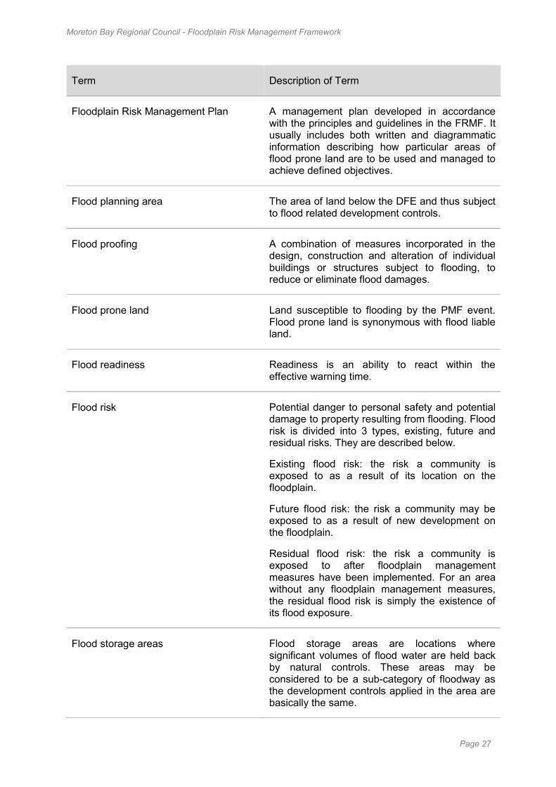
Floodplain Risk Management Plan A management plan developed in accordance with the principles and guidelines in the FRMF. It usually includes both written and diagrammatic information describing how particular areas of flood prone land are to be used and managed to achieve defined objectives.
Flood planning area The area of land below the DFE and thus subject to flood related development controls.
Flood proofing A combination of measures incorporated in the design, construction and alteration of individual buildings or structures subject to flooding, to reduce or eliminate flood damages.
Flood prone land Land susceptible to flooding by the PMF event. Flood prone land is synonymous with flood liable land.
Flood readiness Readiness is an ability to react within the effective warning time.
Flood risk Potential danger to personal safety and potential damage to property resulting from flooding. Flood risk is divided into 3 types, existing, future and residual risks. They are described below.
Existing flood risk: the risk a community is exposed to as a result of its location on the floodplain.
Future flood risk: the risk a community may be exposed to as a result of new development on the floodplain.
Residual flood risk: the risk a community is exposed to after floodplain management measures have been implemented. For an area without any floodplain management measures, the residual flood risk is simply the existence of its flood exposure.
Flood storage areas Flood storage areas are locations where significant volumes of flood water are held back by natural controls. These areas may be considered to be a sub-category of floodway as the development controls applied in the area are basically the same.
Moreton Bay Regional Council - Floodplain Risk Management Framework
Page 28
Term Description of Term
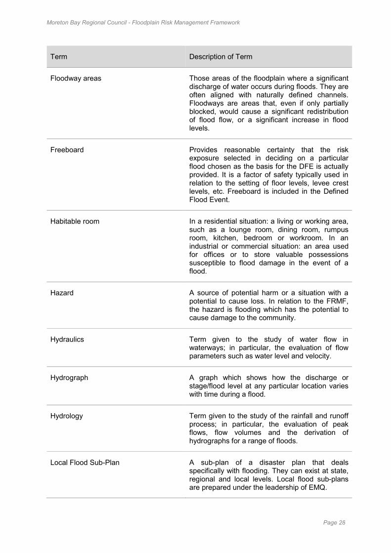
Floodway areas Those areas of the floodplain where a significant discharge of water occurs during floods. They are often aligned with naturally defined channels. Floodways are areas that, even if only partially blocked, would cause a significant redistribution of flood flow, or a significant increase in flood levels.
Freeboard Provides reasonable certainty that the risk exposure selected in deciding on a particular flood chosen as the basis for the DFE is actually provided. It is a factor of safety typically used in relation to the setting of floor levels, levee crest levels, etc. Freeboard is included in the Defined Flood Event.
Habitable room In a residential situation: a living or working area, such as a lounge room, dining room, rumpus room, kitchen, bedroom or workroom. In an industrial or commercial situation: an area used for offices or to store valuable possessions susceptible to flood damage in the event of a flood.
Hazard A source of potential harm or a situation with a potential to cause loss. In relation to the FRMF, the hazard is flooding which has the potential to cause damage to the community.
Hydraulics Term given to the study of water flow in waterways; in particular, the evaluation of flow parameters such as water level and velocity.
Hydrograph A graph which shows how the discharge or stage/flood level at any particular location varies with time during a flood.
Hydrology Term given to the study of the rainfall and runoff process; in particular, the evaluation of peak flows, flow volumes and the derivation of hydrographs for a range of floods.
Local Flood Sub-Plan A sub-plan of a disaster plan that deals specifically with flooding. They can exist at state, regional and local levels. Local flood sub-plans are prepared under the leadership of EMQ.
Moreton Bay Regional Council - Floodplain Risk Management Framework
Page 29
Term Description of Term
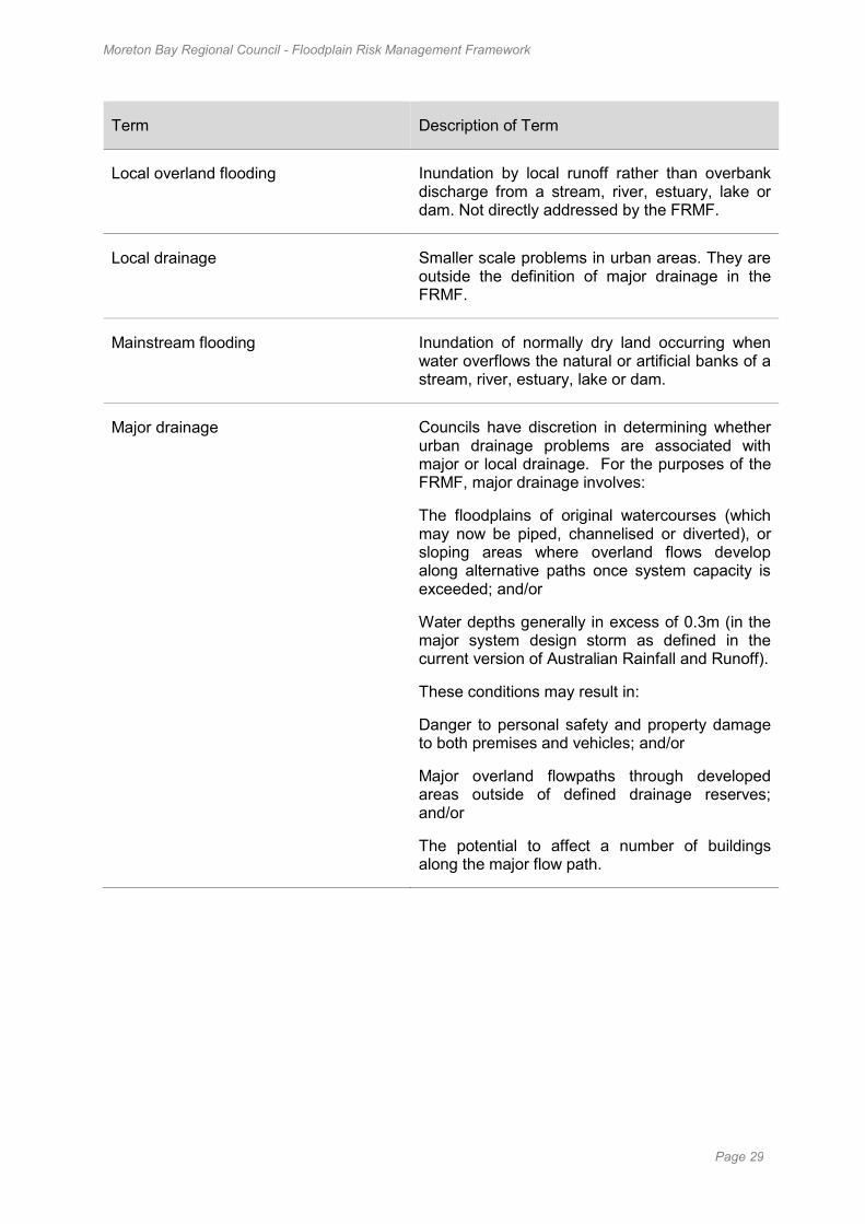
Local overland flooding Inundation by local runoff rather than overbank discharge from a stream, river, estuary, lake or dam. Not directly addressed by the FRMF.
Local drainage Smaller scale problems in urban areas. They are outside the definition of major drainage in the FRMF.
Mainstream flooding Inundation of normally dry land occurring when water overflows the natural or artificial banks of a stream, river, estuary, lake or dam.
Major drainage Councils have discretion in determining whether urban drainage problems are associated with major or local drainage. For the purposes of the FRMF, major drainage involves:
The floodplains of original watercourses (which may now be piped, channelised or diverted), or sloping areas where overland flows develop along alternative paths once system capacity is exceeded; and/or
Water depths generally in excess of 0.3m (in the major system design storm as defined in the current version of Australian Rainfall and Runoff).
These conditions may result in:
Danger to personal safety and property damage to both premises and vehicles; and/or
Major overland flowpaths through developed areas outside of defined drainage reserves; and/or
The potential to affect a number of buildings along the major flow path.
Moreton Bay Regional Council - Floodplain Risk Management Framework
Page 30
Term Description of Term
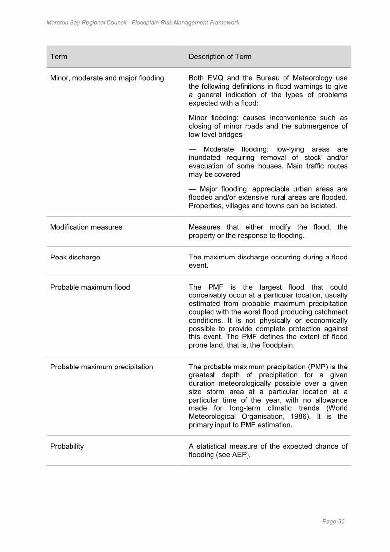
Minor, moderate and major flooding Both EMQ and the Bureau of Meteorology use the following definitions in flood warnings to give a general indication of the types of problems expected with a flood:
Minor flooding: causes inconvenience such as closing of minor roads and the submergence of low level bridges
— Moderate flooding: low-lying areas are inundated requiring removal of stock and/or evacuation of some houses. Main traffic routes may be covered
— Major flooding: appreciable urban areas are flooded and/or extensive rural areas are flooded. Properties, villages and towns can be isolated.
Modification measures Measures that either modify the flood, the property or the response to flooding.
Peak discharge The maximum discharge occurring during a flood event.
Probable maximum flood The PMF is the largest flood that could conceivably occur at a particular location, usually estimated from probable maximum precipitation coupled with the worst flood producing catchment conditions. It is not physically or economically possible to provide complete protection against this event. The PMF defines the extent of flood prone land, that is, the floodplain.
Probable maximum precipitation The probable maximum precipitation (PMP) is the greatest depth of precipitation for a given duration meteorologically possible over a given size storm area at a particular location at a particular time of the year, with no allowance made for long-term climatic trends (World Meteorological Organisation, 1986). It is the primary input to PMF estimation.
Probability A statistical measure of the expected chance of flooding (see AEP).
Moreton Bay Regional Council - Floodplain Risk Management Framework
Page 31
Term Description of Term
Risk Chance of something happening that will have an impact. It is measured in terms of consequences and likelihood. In floodplain investigations, it is the likelihood of consequences arising from the interaction of floods, communities and the environment.
Runoff The amount of rainfall which actually ends up as streamflow, also known as rainfall excess.
Stage Equivalent to water level (both measured with reference to a specified datum).
Stage hydrograph A graph that shows how the water level at a particular location changes with time during a flood.
Survey plan A plan prepared by a registered surveyor.
Value-based approach The value-based approach weighs social, economic, ecological and cultural impacts of land use options for different flood prone areas together with flood damage, hazard and behaviour implications, and environmental protection and well being of the State’s rivers and floodplains. The value-based approach operates at two levels. At the strategic level it allows for the consideration of social, economic, ecological, cultural and flooding issues to determine strategies for the management of future flood risk which are formulated into council plans, policy, and Planning Instruments. At a site specific level, it involves consideration of the best way of conditioning development allowable under the Floodplain Risk Management Plan, local floodplain management policy and Planning Instruments.
Water surface profile A graph showing the flood stage at any given location along a watercourse at a particular time.