FLOODPLAIN MANAGEMENT NEWSLETTER
6
2010 KAFM Conference The 2010 Kansas Association for Floodplain Management conference was September 1 and 2 at the Airport Hilton in Wichita. The conference had an excellent variety of speakers with three sessions from which to choose. Topics included floodproofing, rural oil and gas development, letters of map change, community rating system, decision process, grandfathering, PRP extension, wetland protection, substantial damage, community leadership, federal interagency task force and much more. Along with a great conference, the registration included meals, entertainment and souvenir gifts. In the photo below, some familiar faces lined up for the conference buffet. ___________ In this newsletter… -KAFM Conference -GIS Flood Websites -More Websites -Dam Breach Inundation -Learning Opportunities -Training Registration Form December 2010 KANSAS FLOODPLAIN MANAGEMENT NEWSLETTER
Transcript of FLOODPLAIN MANAGEMENT NEWSLETTER
2010 KAFM Conference The 2010 Kansas Association for Floodplain Management conference was September 1 and 2 at the Airport Hilton in Wichita. The conference had an excellent variety of speakers with three sessions from which to choose. Topics included floodproofing, rural oil and gas development, letters of map change, community rating system, decision process, grandfathering, PRP extension, wetland protection, substantial damage, community leadership, federal interagency task force and much more. Along with a great conference, the registration included meals, entertainment and souvenir gifts. In the photo below, some familiar faces lined up for the conference buffet.
___________
In this newsletter… -KAFM Conference -GIS Flood Websites -More Websites -Dam Breach Inundation -Learning Opportunities -Training Registration Form
December 2010
KANSAS
FLOODPLAIN MANAGEMENT NEWSLETTER
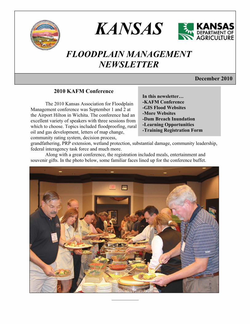
Useful Websites There are two very useful websites for floodplain managers, surveyors and engineers that have been developed by Andy Megrail. One is useful for determining a water surface elevation. To view it: go to http://gis.kda.ks.gov/
ksflood/; zoom in on the map of Kansas; use the panning tool to go to a
specific area; as you zoom in on an area, the
layers will be revealed. The January 2010 Floodplain Management newsletter had a story about BFE and BFA. The available BFE and BFA information is included on this website. Some areas do not have water surface information yet. As new flood mapping projects are completed, new information will become available. The new information will be added to this website. Another excellent website useful for determining whether letters of map change exist for an area. To view it: go to http://gis.kda.ks.gov/kslomc; zoom in on the map of Kansas; as you zoom in on specific areas specific areas, the letters of map change will be
revealed; a mark is at the location; a case number for the letter of map change shows up next to the dot or star; electronic versions of the letter of map change are hyperlinked to the map. This website was created by the Kansas Department of Agriculture’s Division of Water Resources to make it easier to find out about letters of map change. You can use this website to quickly find out if there is a letter of map change for an area and what the case number for that letter of map change is. This website will be updated continually as new information becomes available.
_________
http://gis.kda.ks.gov/ksflood/
Kansas Digital Floodplain Map
Login
Kansas Digital Floodplain Map
ZOOM IN TO ANY AREA
AND THE LAYERS APPEAR

Dam Failure The Lake Delhi dam in Iowa burst July 25, 2010. The 9 mile lake emptied, causing catastrophic flooding downstream. In Hopkinton, people had only five minutes’ warning to evacuate before their homes were flooded. Lake Delhi is one of a number of dams that failed this year in Iowa, Nebraska and Missouri. Kansas has a dam safety program. In a recent evaluation, it ranked as one of the best programs in the United States. Although we have a strong program, many Kansas communities do not. Many do not have regulations that prevent new homes from being built in the inundation area below a dam. This puts lives at risk and causes financial hardship for the owner when the dam is given a high-hazard rating. Some communities have adopted land use regulations that apply to dam breach inundation areas. These areas are often floodplains but can be larger than the floodplain on a flood insurance rate map. The Division of Water Resources has a sample version of “Model Dam Breach Inundation Area Regulations.” You can access the model at http://www.ksda.gov/includes/document_center/structures/Structures/modelord.pdf.
_________ Google Flood Maps Google has incorporated flood maps into their Internet maps. To view the maps, visit https://hazards.fema.gov/femaportal/wps/portal/NFHLWMSkmzdownload. Click on the link under the words “Stay Dry.” This will open Google Earth on your computer. When it opens, there will be instructions over the face of the map. On the left side of the screen there is a column called “Places.” You can click over the button to view flood hazards for an address. Above the column for places is a blank to type in an address. The map will fly to that address and show the flood zones for it. Flood zones are generally shown in red. A legend will appear on one corner of the screen. Below “Places” is a box with “Layers.” A variety of map viewing tools can be used from that box.
_________
Websites This newsletter has a lot of links to useful websites. We suggest that communities also create websites of their own. A community website is worth points under the community rating system. Even if the community is not in CRS, a website is a very useful tool. As the floodplain manager, you may get calls from residents asking for the form to fill out for a floodplain development permit. If that form is already on a website, the caller may find it there and not need to call you. This will save time for the community and the resident. In addition to local permit forms, links to FEMA forms can be placed on a community website. Communities that are getting new flood maps use their websites for outreach to inform residents about grandfathering insurance. Links to Floodsmart.gov also help with flood insurance questions. Consider links to stream gages as a useful item for a website. Make the floodplain management regulations available to be read online. Many times people with questions start looking for answers on the Internet. A well-planned website will help them. If you would like to see some websites created by other communities in Kansas, contact Steve Samuelson at [email protected].
_________

Training Opportunities The Floodplain Management Program will host the following training sessions throughout Kansas. If you are interested in any of the no-cost training opportunities, please contact Tom Morey at (785) 296-5440 or Steve Samuelson at (785) 296-4622. A training registration form is included in this newsletter. How To Read A Flood Map
This is for officials responsible for administering their local floodplain management ordinance. The focus is on the NFIP and concepts of floodplain management, maps and studies, ordinance administration, and the relationship between floodplain management and flood insurance. Limited to 20.
Substantial Damage Estimator This class is for community officials responsible for making damage estimations. The focus will be on the new SDE software that has replaced the RSDE software. Differences between the two programs will be explained. There will also be exercises in using the new software. You will need your own laptop computer for this class.
Westmoreland Feb. 2, 2011 8:30 a.m. to 12:30 p.m.
Wichita Feb. 8, 2011 8:30 a.m. to 12:30 p.m.
2011 Conference Scheduled Mark your calendar! The Kansas Association for Floodplain Management 2011 conference will be September 7 and 8 in Manhattan. More information is available at www.ekafm.org. Registration should be paid through Jon Bristor, Treasurer, 110 E. 10th Street, Wellington, KS 67152. Jon’s phone is (620) 326-2207.
Get Revised MT-EZ Form The MT-EZ form has been revised. The new form expires Sept. 30, 2011. The new form has a new address on page 3. Download the new form at www.fema.gov.
Topeka February 1, 2011 8:30 a.m. to 12:30 p.m.
Valley Center Feb. 9, 2011 8:30 a.m. to 12:30 p.m.
Get This Newsletter by Email If you want to get this newsletter by email, contact Alicia Benson at [email protected].
Good Luck, Andy Andy Megrail has taken a new job working for FEMA Region VII. Although he will be missed at Division of Water Resources, he will still be helping us in Kansas in his new position.
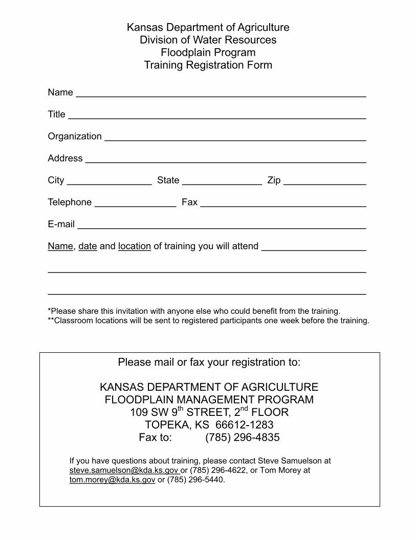
Please mail or fax your registration to:
KANSAS DEPARTMENT OF AGRICULTURE FLOODPLAIN MANAGEMENT PROGRAM
109 SW 9th STREET, 2nd FLOOR TOPEKA, KS 66612-1283
Fax to: (785) 296-4835
If you have questions about training, please contact Steve Samuelson at [email protected] or (785) 296-4622, or Tom Morey at [email protected] or (785) 296-5440.
Kansas Department of Agriculture Division of Water Resources
Floodplain Program Training Registration Form
Name Title Organization Address City State Zip Telephone Fax E-mail Name, date and location of training you will attend *Please share this invitation with anyone else who could benefit from the training. **Classroom locations will be sent to registered participants one week before the training.
Please help us keep our records current. If the name that appears on this newsletter is for an individual no longer with your organization, please call (785) 296-7769, or send an e-mail to [email protected]
KDA/DWR Water Structures Floodplain Program Staff
Tom Morey, CFM, RS, NFIP Coordinator (785) 296-5440 [email protected] Andy Megrail, CFM, Floodplain Mapping Specialist (785) 296-2513 [email protected] Steve Samuelson, CFM, NFIP Specialist (785) 296-4622 [email protected] Alicia Benson, CFM, Floodplain Coordinating Assoc. (785) 296-7769 [email protected]
Mailing Address: 109 SW 9th Street, 2nd Floor Topeka, KS 66612-1283 Fax: (785) 296-4835 www.ksda.gov/dwr
ASFPM 2011 National Conference in Kentucky The 2011 Association of State Floodplain Managers National Conference will be May 15-20, 2011, in Louisville, Kentucky. This conference is an excellent opportunity for floodplain managers to receive premier training on mapping technologies, adopting new flood hazard maps, and to discuss topics directly related to mapping and map modernization. More than 1,200 floodplain management professionals and officials will attend the conference, and we hope you can attend this important event. In past years, DWR was able to provide financial assistance to Kansas community officials so they could attend the ASFPM conference. No funds will be available in 2011.
___________
046-17 Kansas Department of Agriculture Division of Water Resources Floodplain Management 109 SW 9th St 2nd Floor Topeka, KS 66612-1283