2009 FLOODPLAIN MANAGEMENT IN KENTUCKY …water.ky.gov/floodplain/Documents/KYQG Web.pdfQuick Guide...
68
Quick Guide FLOODPLAIN MANAGEMENT IN KENTUCKY 2009 Kentucky Division of Water / Flood Mitigation Program 200 Fair Oaks Lane, Frankfort, KY 40601 502-564-3410 http://www.water.ky.gov
Transcript of 2009 FLOODPLAIN MANAGEMENT IN KENTUCKY …water.ky.gov/floodplain/Documents/KYQG Web.pdfQuick Guide...
QuickGuide
FLOODPLAIN MANAGEMENT IN KENTUCKY2009
Kentucky Division of Water / Flood Mitigation Program200 Fair Oaks Lane, Frankfort, KY 40601502-564-3410 http://www.water.ky.gov

Table of Contents
1..... About this Guide2..... Kentucky Disaster Declarations3..... National Flood Insurance Program4..... NFIP Community Rating System5..... Why Do We Regulate the Floodplain?6..... Community Responsibilities7..... Introduction to the Riverine Watershed8..... Natural and Beneficial Floodplain Function9..... Annual Chance Floods10... Understanding the Riverine Floodplain11 ... Understanding the Floodway12... Looking for Floodplain Information?13... Online Flood Map Tools14... Old Format Flood Insurance Rate Map15... Flood Insurance Rate Map16... The Countywide Digital FIRM 17... Flood Boundary and Floodway Map18... Use the Stream Flood Profile to Determine BFEs19... Floodway Data Tables20... Approximate Zone A21... Letters of Map Change22... Nature Doesn’t Read Maps!
23... Safe Uses of the Floodplain24... What is Meant by Pre-FIRM and Post-FIRM?25... Basements Are Unsafe in Special Flood Hazard Areas26... Some Activities Requiring Floodplain Development Permits27... Some Key Steps in Floodplain Development Permit Review 28... Carefully Complete the Permit Application29... Commonwealth Permit for Stream Construction30... Think Carefully Before You Seek a Variance31... Development Can Increase Flooding32... Required Floodway “No Rise/No Impact ” Certification33... What is an Elevation Certificate and How is it Used?34... Completing the Elevation Certificate35... Is Your Building Site Higher than the BFE?36... The Lowest Floor37... How to Elevate Your Floodplain Structure38... Compaction of Floodplain Fill39... Elevating an Existing Structure40... Enclosures Below the Lowest Floor41... Crawlspace Details42... Utility Service / Fuel Tanks43... Utility Service Inside Enclosures44... Low Cost Flood Protection for Older Homes

45... Septic Tanks46... Small Berms/Floodwalls Can Protect Pre-FIRM Structures47... Acquisition/Demolition and Relocation48... Floodprone Property Acquisition Projects49... Manufactured Homes Deserve Special Attention50... Recreational Vehicles51... Accessory Structures52... Planning to Improve Your Floodplain Building?53... Substantial Improvement: Renovation Only54... Substantial Improvement: Lateral Addition Only
55... Substantial Improvement: Addition Plus Other Work56... Non-Substantial Improvements57... What About After Damage?58... Residential Substantial Damage Estimator59... Paying for Post Flood Compliance - ICC60... Flood Insurance: Property Owner’s Best Protection61... Freeboard: Go Above the BFE62... Flood Zones63... Useful Resources64... Want to Learn More?
Table of Contents (continued)
1 kentucky quick guide
This Quick Guide will help you understand more about why and how communities in the Commonwealth of Kentucky manage floodplains and regulate floodplain development to protect people and property.
Floodprone communities adopt ordinances that detail the rules and requirements for floodplain development. In case of conflict, that ordinance and not this publication, must be followed. Please direct questions and comments on this Quick Guide to the Kentucky Division of Water, Floodplain Management Section at 502-564-3410 or online at http://www.water.ky.gov.
For more detail on all aspects of floodplain management, please refer to the Kentucky Floodplain Administrators Handbook and the Federal
Emergency Management Agency (FEMA) National Flood Insurance Program Floodplain Management Requirements Study Guide and Desk Reference for Local Officials (FEMA 480).
The development and publication of this Quick Guide was taxpayer funded through the Federal Emergency Management Agency.
About this Guide

2 kentucky quick guide
Commonwealth of KentuckyPresidential Disaster Declarations
Number of Declarations by County (1994-2008)
Not all flood events are declared major disasters. Floodprone areas have been identified in many counties, cities and towns in Kentucky. Many floods are local, affecting only small areas, such as a few homes, a limited number of communities or a few watersheds. Floods cause significant economic losses in Kentucky. Since 1978, flood insurance policy holders have received over $206 million in claim payments.
Kentucky Disaster Declarations
1 to 56 to 1011 to 13
Pike
Floyd
MartinJohnson
Lawrence
Boyd
Letcher
Knott
Magoffin
Elliott
Carter
Greenup
Harlan
Leslie
Perry
Breathitt
Wolfe
Morgan
Rowan
Lewis
Bell
Knox
Clay
Owsley
Lee
Menifee
Bath
Fleming
Mason
Whitley
Laurel
Jackson
Estill
PowellM
ontgomery
Nicholas
sonRobert-
Bracken
castleRock-
Madison
Clark
Bourbon
Harrison
tonPendle-
Campbell
Kenton
McCrearyWayne
Pulaski
Lincoln
Garrard
mineJessa-
Fayette
Scott
Grant
Boone
Clinton
Russell
Casey
Boyle
Mercer
Anderson
Woodford
Franklin
OwenHenry
Gallatin
Carroll
landCumber-
Adair
Taylor
Marion
ingtonWash-
Spencer
Shelby
Oldham
Trimble
Monroe
Metcalfe
Green
Larue
Nelson
Bullitt
Jefferson
Allen
Barren
Hart
Hardin
Meade
Simpson
Warren
Edmonson
Grayson
Breckinridge
Logan
Butler
Ohio
Hancock
Todd
Muhlenberg
McLean
Daviess
Christian
Hopkins
Webster
Henderson
Trigg
Caldwell
Union
Lyon
Crittenden
Calloway
Marshall
Livingston
Graves
McCracken
Fulton
Hickman
Carlisle
Ballard

3 kentucky quick guide
National Flood Insurance Program
To learn more about the NFIP, the benefits of participation and the impact of non-participation in communities that have identified Special Flood Hazard Areas within their jurisdictional boundaries go to:http://www.water.ky.gov/floodplainmanagement/nationalfloodinsuranceprogram/
The National Flood Insurance Program (NFIP) was created by Congress in 1968 to protect lives and property and to reduce the financial burden of providing disaster assistance. The NFIP is administered by the Federal Emergency Management Agency. Nationwide, over 20,000 communities participate in the NFIP — including most of Kentucky's floodprone communities.
The NFIP is based on a mutual agreement between the federal government and communities. Communities that participate agree to regulate floodplain development according to certain criteria and standards.
The partnership involves:
Flood Insurance�� – Property owners in participating communities are eligible to purchase federal flood insurance for buildings and contents.Flood Hazard Maps�� – In partnership with FEMA, the state produces flood maps in accordance with FEMA standards. The maps are used by communities, insurance agents and others.
Regulations�� – Communities must adopt and enforce minimum floodplain management regulations so that development, including buildings, is undertaken in ways that reduce exposure to flooding.

4 kentucky quick guide
NFIP Community Rating System
Property owners in 16 Kentucky communities with a "Class 9" or better CRS rating receive discounts ranging from 5% to 25% for properties in a Special Flood Hazard Area (SFHA) and 5% to 10% for properties not in a SFHA. For detailed information about the CRS program go to http://training.fema.gov/EMIWeb/CRS/.
The NFIP’s Community Rating System (CRS) is a voluntary program that provides communities the opportunity to reduce flood insurance premiums for its citizens. Communities in the regular phase of the NFIP may apply to participate in the CRS. To participate the community must commit to implement and certify activities that contribute to reduced flood risk. Examples of actions communities can take to reduce the cost of flood insurance premiums include:
Inform people about floodplain management, flood hazards, flood insurance and flood protection.��
Monitor flood conditions, issue warnings and coordinate flood response activities.��
Preserve open space in the floodplain��
Enact and enforce higher standards for safer development��
Maintain the flood carrying and storage capacity of drainage systems.��
Undertake engineering studies and develop floodplain maps and flood data.��
Obtain grants to buy out or elevate houses or to floodproof businesses.��
5 kentucky quick guide
Why Do We Regulate the Floodplain?
To protect people and property – Floodplain management is about reducing vulnerability to flood risk to our built environment. If we know low lying land will flood from time to time, we should make reasonable decisions to help protect our families, homes, and businesses.
To reduce future flood losses in Kentucky – Floodplain development regulations are simply a “good neighbor” policy designed to protect our citizens from future flood losses. Regulating floodplain development helps keep flooding conditions from getting worse as development continues.
To make sure that federal flood insurance is available – Your community must join the NFIP before its residents can purchase flood insurance. If not, your community can be ineligible for some types of federal assistance. In addition, your residents may be unable to secure a mortgage.
To save tax dollars – Every time you hear about a flood disaster, think about what it means to the town’s budget. If we build smart, we’ll have fewer problems the next time the water rises. Remember, federal disaster assistance is not available for all floods. Even when the President declares a disaster, your community still has to pay a portion of repair and clean-up costs and could also incur some evacuation expenses.
To avoid liability and lawsuits – If we know an area is mapped as a floodplain and likely to flood and we know people could be in danger and buildings could be damaged, doesn’t it make sense to take reasonable protective steps as we develop and build?
6 kentucky quick guide
Community Responsibilities
To participate in the NFIP, your community agrees to adopt and enforce a flood damage prevention ordinance. Responsibilities required by ordinances include, but may not be limited to:
Require�� Elevation Certificates to document compliance.
Require �� new and substantially improved residential structures and manufactured homes to be elevated to or above the BFE.
Conduct�� field inspections and cite any violations to the community’s Flood Damage Prevention Ordinance.
Require�� non-residential structures to be elevated or floodproofed.
Ensure�� that building sites are reasonably safe from flooding.
Carefully�� consider requests for variance.
Advise�� FEMA when updates to flood maps are needed.
How FloodSmart are YOU?

7 kentucky quick guide
Introduction to the Riverine Watershed
A watershed is the area of land that drains runoff to a point on a waterway. Sometimes it is called the drainage basin. The size and shape of a watershed depends on the shape of the land, the underlying geology, the steepness of the slopes, and how many small waterways, or tributaries, join the larger waterway.
Every river, creek, stream and ditch has a watershed. Many small watersheds, or sub-watersheds, combine to make large watersheds.
watershed boundary
waterway channel
upland

8 kentucky quick guide
Undeveloped floodplains can serve natural and beneficial functions. They:
Store flood water and stormwater.��
Enhance water quality by filtering runoff through wetlands.��
Offer habitats for plants and animals.��
Sustain biological productivity.��
Reduce erosion and sediment runoff.��
Offer recreation opportunities.��
The Association of State Floodplain Managers, Inc. developed the NAI concept in response to rising flood damages, even though communities administer floodplain management ordinances. At http://www.floods.org, click on the NAI tab to download publications, the NAI Tool Kit and PowerPoint as well as several documents about legal issues.
"No Adverse Impact" (NAI) floodplain management is essentially a "do-no-harm" policy based on the concept that the actions of any community or property owner should not adversely affect others. It calls for identifying the potential direct and indirect adverse impacts of any development action on people, property and the environment. Adverse impacts must be avoided or mitigated.
No Adverse Impact
Asso
ciation of State Floodplain Managers, In
c.Natural and Beneficial Floodplain Function

9 kentucky quick guide
10 25 50 100 500 Yr Yr Yr Year Year
6%
26%
45%
71%
96%
10%
20%
30%
40%
50%
60%
70%
80%
90%
100%
DefinitionsTerms and
The 1%-annual chance flood, also called the Base Flood, has been selected by the National Flood Insurance Program as the basis for delineation of Special Flood Hazard Areas (SFHA) on Flood Insurance Rate Maps (FIRMs). The Special Flood Hazard Area is the basis for floodplain regulations administered by Kentucky's communities.
The boundary of the floodplain delineated for the 0.2%-annual chance flood (also called the 500-year flood) sometimes is shown on the NFIP flood maps.
Annual Chance Floods
The Base Flood is the 1%-annual chance flood (commonly called the 100-year flood). The 1%-annual chance flood has a 26% chance of occurring during a 30 year period.The 0.2%-annual chance flood (or 500-year flood) has a 6% chance of occurring during a 30-year period.
PR
OB
AB
ILIT
Y O
F B
EIN
G E
QU
ALL
ED
OR
E
XC
EE
DE
D D
UR
ING
A 3
0-P
ER
IOD

10 kentucky quick guide
Understanding the Riverine Floodplain
For floodplains with Base Flood Elevations, check the Flood Insurance Study (FIS) to find the Flood Profile which shows water surface elevations for the different frequency floods (see page 18).
DefinitionsTerms andOne-Percent Annual Chance Floodplain
(100-Year Floodplain)
Floodway Fringe
Floodway
Stream Channel
Floodway Fringe
Special Flood Hazard Area
The Special Flood Hazard Area (SFHA) is that portion of the floodplain subject to inundation by the base flood (1%-annual chance) and/or flood-related erosion hazards. SFHAs are shown on FHBMs or FIRMs as Zones A, AE, A1-A30, AH, AO, and AR.See page 11 to learn about the floodway, the area of the floodplain where floodwaters usually flow faster and deeper.
normal waterlevel
floodlevel

11 kentucky quick guide
Before a local permit can be issued for proposed development in the floodway, a “No Rise/No Impact” certification must be submitted (see page 32). You may need a Professional Engineer licensed in Kentucky, to make sure your proposed project won't increase flood levels.
Understanding the Floodway
DefinitionsTerms and
The Floodway is the channel of a river or other water course and the adjacent land areas that must be reserved in order to pass the base flood discharge without cumulatively increasing flood levels by a designated height.Computer models of the floodplain are used to simulate “encroachment” or fill in the floodway fringe in order to predict where and how much the Base Flood Elevation (BFE) would increase if the floodplain is allowed to be filled.
Floodway Fringe
Floodway Fringe
Stream ChannelSimulated
Encroachment
Surcharge*
Flood elevation before encroachmentArea of floodplain that could be
used for development by raising ground
= Flood elevation before encroachment
= Flood elevation after encroachment
Line
Simulated Encroachment*Surcharge not to exceed 1.0 ft (NFIP requirement)
Simulated Encroachment
Line
AC D
B
A BC D
Floodway
Special Flood Hazard Area
12 kentucky quick guide
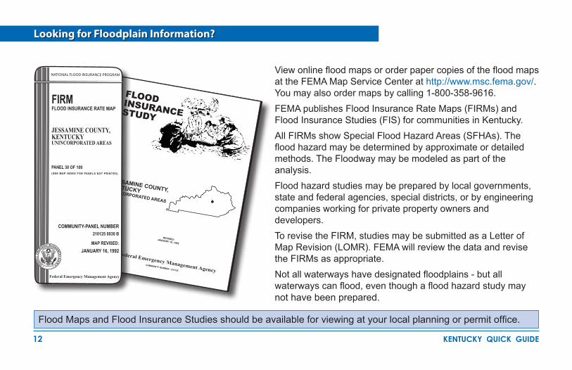
Looking for Floodplain Information?
Flood Maps and Flood Insurance Studies should be available for viewing at your local planning or permit office.
View online flood maps or order paper copies of the flood maps at the FEMA Map Service Center at http://www.msc.fema.gov/. You may also order maps by calling 1-800-358-9616. FEMA publishes Flood Insurance Rate Maps (FIRMs) and Flood Insurance Studies (FIS) for communities in Kentucky.All FIRMs show Special Flood Hazard Areas (SFHAs). The flood hazard may be determined by approximate or detailed methods. The Floodway may be modeled as part of the analysis. Flood hazard studies may be prepared by local governments, state and federal agencies, special districts, or by engineering companies working for private property owners and developers.To revise the FIRM, studies may be submitted as a Letter of Map Revision (LOMR). FEMA will review the data and revise the FIRMs as appropriate.Not all waterways have designated floodplains - but all waterways can flood, even though a flood hazard study may not have been prepared.
COMMUNITY NUMBER • 210125
Federal Emergency Management Agency
REVISED: JANUARY 16, 1992
JESSAMINE COUNTY, KENTUCKYUNINCORPORATED AREAS
FLOOD INSURANCE STUDY
Federal Emergency Management Agency
COMMUNITY-PANEL NUMBER210125 0030 B
MAP REVISED:JANUARY 16, 1992
FIRMFLOOD INSURANCE RATE MAP
JESSAMINE COUNTY,KENTUCKYUNINCORPORATED AREAS
PANEL 30 OF 100(SEE MAP INDEX FOR PANELS NOT PRINTED)
NATIONAL FLOOD INSURANCE PROGRAM
13 kentucky quick guide
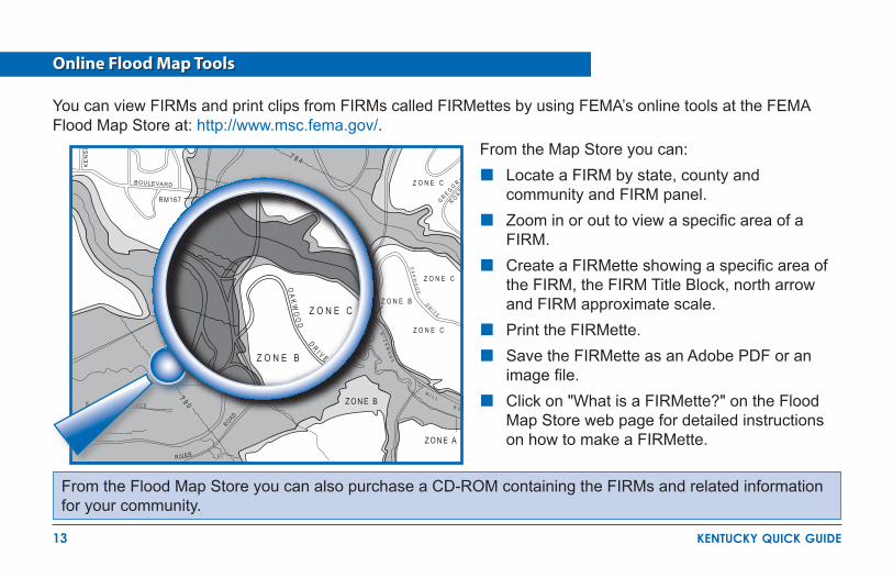
From the Map Store you can:Locate a FIRM by state, county and ��community and FIRM panel.Zoom in or out to view a specific area of a ��FIRM.Create a FIRMette showing a specific area of ��the FIRM, the FIRM Title Block, north arrow and FIRM approximate scale.Print the FIRMette.��
Save the FIRMette as an Adobe PDF or an ��image file.Click on "What is a FIRMette?" on the Flood ��Map Store web page for detailed instructions on how to make a FIRMette.Z O N E A
Z O N E B
Z O N E C
Z O N E B
Z O N E C
Z O N E C
RM167
BOULEVARD
KE
NS
I
S RACE
RIVER
ROAD
7 9 0 R O
M I L L
MI C
KM
AN
S
OA
KW
OO
D D R I V E
R O A D
G R E G O R Y
7 8 4
Z O N E B
Z O N E C
OA
KW
OO
D D R I V E
From the Flood Map Store you can also purchase a CD-ROM containing the FIRMs and related information for your community.
Online Flood Map Tools
You can view FIRMs and print clips from FIRMs called FIRMettes by using FEMA’s online tools at the FEMA Flood Map Store at: http://www.msc.fema.gov/.

14 kentucky quick guide
FEMA prepares Flood Insurance Rate Maps (FIRMs) to show areas that are at high risk of flooding after intense or major storms. Most FIRMs show the flood elevation (how high the water may rise), called the Base Flood Elevation.
Old Format Flood Insurance Rate Map
FLOOD HAZARD ZONES
Zone C (or Zone X) is all other areas, considered to be low risk.
Zone B (or shaded Zone X) is subject to flooding by the 0.2% annual chance (500-year) flood, and is a moderate risk area.
Zone A, Zones A1-A30 and Zone AE are subject to flooding by the base or 1% annual chance (100-year) flood, and are considered high risk areas.
Base Flood Elevation (BFE).Water surface elevation of the base flood at specific locations.
692693
694
695
697
699
ZONE A6
RM55
NORTH TYGER
RIVER
ZONE B ZONE B
ZONE C

15 kentucky quick guide
Flood Insurance Rate Map
P
PNM
M
L
L
oo
EARLWOOD DRIVE
213
21
321
CO
LES
DRIVE
xRM 92-2
Tributary SM-3
DRIVE
ABIN
GD
ON
610
610
610
609
609609ZONE AE
ZONE X
ZONE A
6
5
4
3
2
1 Zone A (approximate) is the 1% annual chance floodplain without BFEs.
Zone AE is the 1%-annual chance (100-year) floodplain with BFEs (also called Zone A1- A30).
Zone X (shaded or unshaded) is all other areas considered low risk (formerly Zone B or C).
Base Flood Elevation (BFE) is the water surface elevation, rounded to the nearest foot, of the base flood at specific locations.
The Floodway is the cross-hatched area.
Cross Section location (see page 17).
16 kentucky quick guide
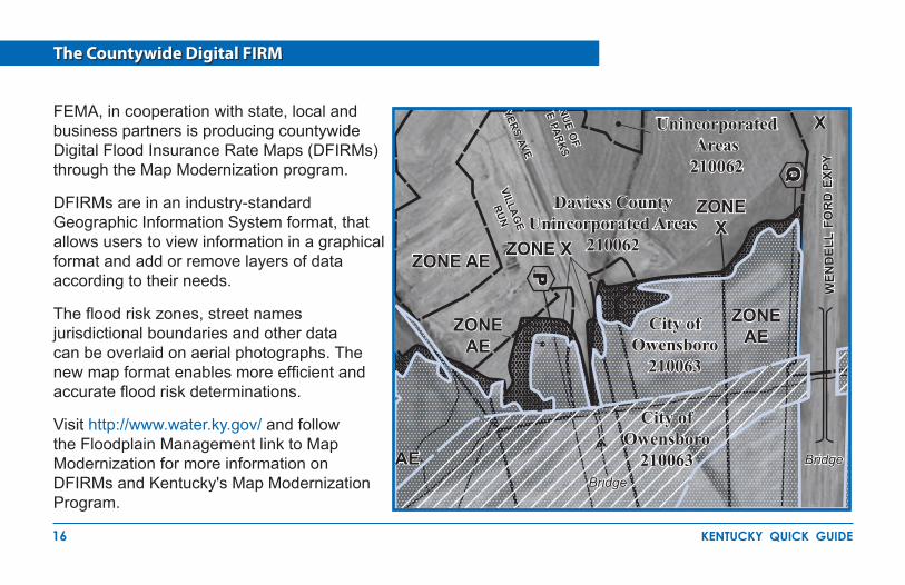
The Countywide Digital FIRM
FEMA, in cooperation with state, local and business partners is producing countywide Digital Flood Insurance Rate Maps (DFIRMs) through the Map Modernization program.
DFIRMs are in an industry-standard Geographic Information System format, that allows users to view information in a graphical format and add or remove layers of data according to their needs.
The flood risk zones, street names jurisdictional boundaries and other data can be overlaid on aerial photographs. The new map format enables more efficient and accurate flood risk determinations.
Visit http://www.water.ky.gov/ and follow the Floodplain Management link to Map Modernization for more information on DFIRMs and Kentucky's Map Modernization Program.
PP
Bridge
WEN
DEL
L FO
RD E
XPY
X
ZONE AE
ZONE X
Unincorporated Areas
210062
Bridge
City ofOwensboro
210063
City ofOwensboro
210063
Daviess CountyUnincorporated Areas
210062
NUE OF
E PARKS
ZONE X
VILLAGE
RUNYERS AVE
AE
ZONE AE
ZONE AE
Bridge
WEN
DEL
L FO
RD E
XPY
X
ZONE AE
ZONE X
Unincorporated Areas
210062
Bridge
City ofOwensboro
210063
City ofOwensboro
210063
Daviess CountyUnincorporated Areas
210062
NUE OF
E PARKS
ZONE X
VILLAGE
RUNYERS AVE
AE
ZONE AE
ZONE AE
17 kentucky quick guide
InformationImportant
B
B
A
A
DH
DG
DG
DF
DE
DE
DD
DC
RM55
CDA
DA
NORTH TYGER
RIVER
Grays Creek
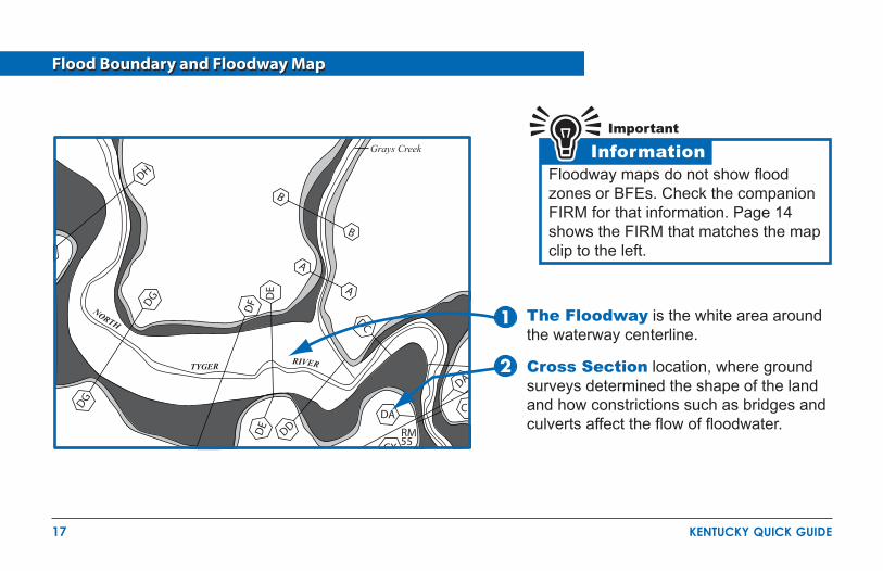
Flood Boundary and Floodway Map
Floodway maps do not show flood zones or BFEs. Check the companion FIRM for that information. Page 14 shows the FIRM that matches the map clip to the left.
The Floodway is the white area around the waterway centerline.
Cross Section location, where ground surveys determined the shape of the land and how constrictions such as bridges and culverts affect the flow of floodwater.

18 kentucky quick guide
Use the Stream Flood Profile to Determine BFEs
E F
2
1
1
1
2
Roa
d
STREAM DISTANCE IN MILES ABOVE CONFLUENCE
ELE
VA
TIO
N I
N F
EE
T (
NG
VD
)
530
540
550
7.4 7.6 7.8 8.0 8.2 8.4 8.6 8.8
A
STREAM BED
CROSS SECTIONLOCATION
50-YEAR FLOOD
10-YEAR FLOOD
100-YEAR FLOOD
500-YEAR FLOOD Flood profiles can be used to determine the BFE at a specific site. Profiles also show estimated water surface elevations for floods other than the 1%-percent annual chance flood.
On the Flood Insurance Rate Map, locate your site by measuring the distance along the centerline of the stream channel from a cross section, for example, E or F .
Scale that distance on the flood profile and read up to the profile of interest, then across to determine the elevation.
In this example, at 7.95 miles above the confluence the BFE is 553 feet.

19 kentucky quick guide
The Flood Insurance Study (FIS) has a Floodway Table for every waterway that was studied by detailed methods for which floodways were delineated.
This is the only readily available velocity data to use in computations of hydrodynamic loads.
Computed BFE (rounded values are shown on the FIRM).
Amount of allowable increase - not more than 1-foot at any location.
Floodway Base Flood Water Surface Elevationwidth (feet)
section area (square feet
mean velocity (feet per second)
regulatory without floodway
with floodway increase
124 44 41 52 68
209 125 176 205 247
1.01.61.11.00.8
391.1395.5396.6398.4398.5
391.1395.5396.6398.4398.5
392.1396.3397.4399
399.1
1.00.80.80.60.6
The Floodway delineates that portion of the SFHA that must be reserved to convey the Base Flood without increasing the water surface elevation more than the amount specified in the Floodway Table.
Floodway Data Tables
20 kentucky quick guide
Approximate Zone A
B E L T R O A DO U T E R
ZONE A
150 XRM 219
LEAF RIVER
NO
RR
IS
ST.
VIR
GIL
ST.
MAY
ST.
SWORD ST
HAW
ST.
HANCOCK DR
PECAN ST.
ZONE A
ZONE A
ZONE C
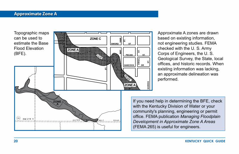
Topographic maps can be used to estimate the Base Flood Elevation (BFE).
Approximate A zones are drawn based on existing information, not engineering studies. FEMA checked with the U. S. Army Corps of Engineers, the U. S. Geological Survey, the State, local offices, and historic records. When existing information was lacking, an approximate delineation was performed.
If you need help in determining the BFE, check with the Kentucky Division of Water or your community's planning, engineering or permit office. FEMA publication Managing Floodplain Development in Approximate Zone A Areas (FEMA 265) is useful for engineers.

21 kentucky quick guide
Letters of Map Change
InformationImportantLetter of Map Amendment (LOMA)�� is an official change to an effective FIRM that
may be issued when a property owner provides additional technical information such as ground elevation relative to the BFE, SFHA and the building. Lenders may waive the flood insurance requirement if the LOMA documents a structure on ground is above the mapped floodplain.
Letter of Map Revision (LOMR)�� is an official change to an effective FIRM that may be issued to change flood insurance risk zones, floodplain and boundary delineations, BFEs, and/or other map features. Lenders may waive the flood insurance requirement if the approved map revision shows structures to be outside of the SFHA.
Letter of Map Revision Based on Fill (LOMR-F)�� is an official change to an effective FIRM that is issued to document FEMA's determination that a structure or parcel of land has been elevated by fill above BFE, and therefore is no longer in the SFHA. Lenders may waive the flood insurance requirement if the LOMR-F shows a structure on fill is above the BFE and outside of the SFHA.
Physical Map Revision (LOMR-PMR)�� may be issued for major physical floodplain changes that require engineering analyses, such as bridges, culverts, channel changes, flood control measures, and large fills that change the BFE or Floodway. PMRs are also issued when a new study updates or improves the FIRM.
1
2
3
4
Check FEMA's Flood Hazard Mapping website for more information about map revisions concerning homeowners, engineers, and surveyors. To learn the Status of Map Change Requests, call FEMA's Map Service Center at 1-800-358-9616.Information:http://www.fema.gov/hazard/map/lomcForms:http://www.fema.gov/business/nfip/forms
Requests for map revisions must be endorsed by your community.
22 kentucky quick guide
InformationImportant
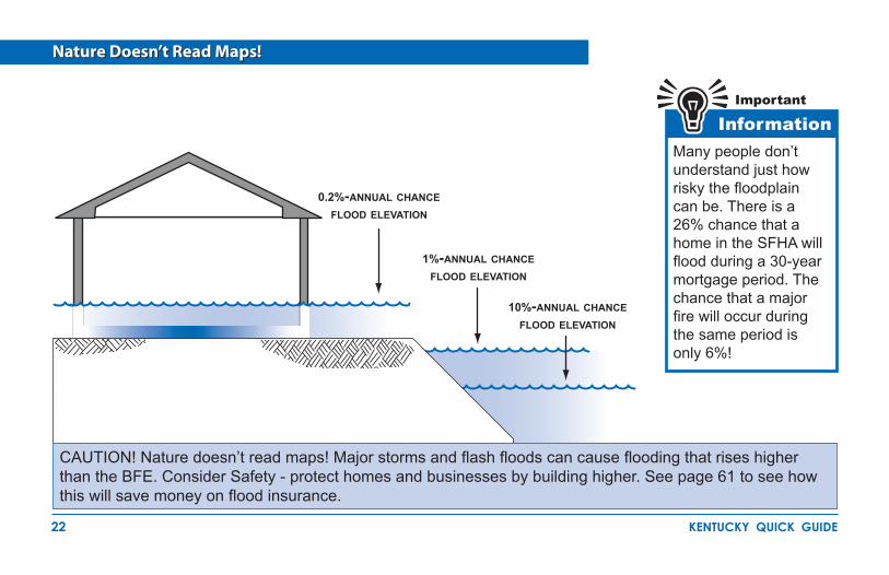
0.2%-annual chance flood elevation
Many people don’t understand just how risky the floodplain can be. There is a 26% chance that a home in the SFHA will flood during a 30-year mortgage period. The chance that a major fire will occur during the same period is only 6%!
10%-annual chance flood elevation
1%-annual chance flood elevation
Nature Doesn’t Read Maps!
CAUTION! Nature doesn’t read maps! Major storms and flash floods can cause flooding that rises higher than the BFE. Consider Safety - protect homes and businesses by building higher. See page 61 to see how this will save money on flood insurance.
23 kentucky quick guide
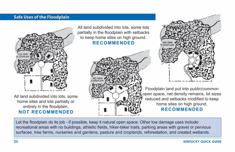
Safe Uses of the Floodplain
All land subdivided into lots, some home sites and lots partially or
entirely in the floodplain. NOT RECOMMENDED
All land subdivided into lots, some lots partially in the floodplain with setbacks
to keep home sites on high ground. RECOMMENDED
Floodplain land put into public/common open space, net density remains, lot sizes
reduced and setbacks modified to keep home sites on high ground.
RECOMMENDED
Let the floodplain do its job - if possible, keep it natural open space. Other low damage uses include: recreational areas with no buildings, athletic fields, hiker-biker trails, parking areas with gravel or pervious surfaces, tree farms, nurseries and gardens, pasture and croplands, reforestation, and created wetlands.
24 kentucky quick guide
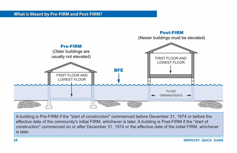
What is Meant by Pre-FIRM and Post-FIRM?
A building is Pre-FIRM if the "start of construction" commenced before December 31, 1974 or before the effective date of the community's initial FIRM, whichever is later. A building is Post-FIRM if the "start of construction" commenced on or after December 31, 1974 or the effective date of the initial FIRM, whichever is later.
Pre-FIRM(Older buildings are usually not elevated)
Post-FIRM(Newer buildings must be elevated)
FIRST FLOOR AND LOWEST FLOOR
FIRST FLOOR AND LOWEST FLOOR
BFE
floodopening/vents

25 kentucky quick guide
Basements Are Unsafe in Special Flood Hazard Areas
DefinitionsTerms and
Basements below BFE are not allowed in new development and flood insurance coverage is very limited in existing basements for very good reason. It only takes an inch of water over the sill and the entire basement fills up! Excavating a basement into fill doesn't always make it safe because saturated groundwater can damage the walls.
hydrostaticpressure
basement windowground
lowest floor
A basement is any portion of a structure that has a subgrade floor (below ground level) on all sides.
SUBGRADEBASEMENT
LIVING AREA LIVING AREAfill level
saturated ground/fill
BFEBASEMENT
IN FILL
Not Allowed May Not Be Safe
26 kentucky quick guide
Some Activities Requiring Floodplain Development Permits
Y O U N E E D P E R M I T S F O R A L L O F T H E S E A C T I V I T I E S
New construction��
Additions to existing structures��
Substantially improved structures��
Placing manufactured (mobile) homes��
Subdivision development, including infrastructure��
Temporary buildings and accessory structures��
Agricultural buildings��
Parking or storage of recreational vehicles��
Temporary or permanent materials storage, including�� gas/liquid storage and sand/gravel
Roads, bridges, and culverts��
Fill, grading, excavation, mining, and dredging��
Stream alteration or relocation��
Regulate Development
Technical Assistance
Map
s and Insurance
PartnershipReduce Risks
Mitigate Flood Damage
PartnershipReduce Risks
Mitigate Flood Damage

27 kentucky quick guide
FloodplainFloodwayBFENew ConstructionImproved Existing Building
ElevatedElevation CertificateIssue Permit
Review Checklist
Some Key Steps in Floodplain Development Permit Review
The Permit Reviewer has to check many things. Key Questions are:
Is the site in an identified�� floodplain? Is the site in the mapped floodway?��
Have all state and federal permits been obtained?��
Is the site "reasonably safe from flooding"?��
Does the site plan show the Base Flood Elevation?��
Does the site plan show existing ground contours?��
Is substantial improvement of an older building being ��proposed?Is an addition proposed?��
Will new structures and utilities be properly elevated and ��anchored?Will the manufactured home be properly elevated and ��anchored?Do the plans show an appropriate and safe foundation?��
Has the owner submitted an Elevation Certificate?��

28 kentucky quick guide
Carefully Complete the Permit Application
Good information will lead to better construction and less exposure to future flood damage.
You must get all permits before you do work in a floodplain.
InformationImportant
59
REED
S
T
X
RM 25
STREET
FRANKE
HOUSE
STREET
FILL
ZONE X
S STREET
(excerpts)
Dave and Sally Jones
781 Any Street
000-000-0000 Dave and Sally@
Joe Engineer 000
New Single Family Home
Anycounty Anytown
Anyquad 38.15
Water Creek
122
South on Highway X to Water Creek turn

29 kentucky quick guide
Commonwealth Permit for Stream Construction
InformationImportantConstruction across or along a stream requires authorization from the ��
Kentucky Division of Water and from local communities.
Learn more about the Stream Construction permit at �� http://www.water.ky.gov/permitting.
Activities that involve work in a wetland or a stream (bank stabilization, ��filling, dredging, or channel relocation) must receive a "401 Water Quality Certification" from the Kentucky Division of Water.
The Division of Water provides technical assistance when floodplain ��information is not readily available.
Certain activities that are proposed in a corridor of a designated Wild River must obtain written authorization from the Kentucky Division of Water before construction is started.
Floodplain activities that must have a Division of Water Permit include construction of buildings, placement of fill, stream alterations, bridges, culverts, and dams.
30 kentucky quick guide
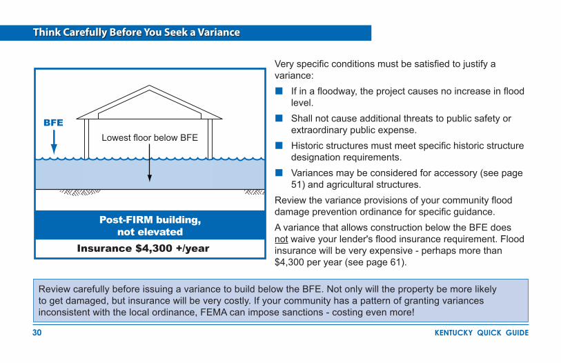
Think Carefully Before You Seek a Variance
Review carefully before issuing a variance to build below the BFE. Not only will the property be more likely to get damaged, but insurance will be very costly. If your community has a pattern of granting variances inconsistent with the local ordinance, FEMA can impose sanctions - costing even more!
Post-FIRM building,not elevated
BFE
Insurance $4,300 +/year
Very specific conditions must be satisfied to justify a variance:
If in a floodway, the project causes no increase in flood ��level.Shall not cause additional threats to public safety or ��extraordinary public expense.Historic structures must meet specific historic structure ��designation requirements.Variances may be considered for accessory (see page ��51) and agricultural structures.
Review the variance provisions of your community flood damage prevention ordinance for specific guidance. A variance that allows construction below the BFE does not waive your lender's flood insurance requirement. Flood insurance will be very expensive - perhaps more than $4,300 per year (see page 61).
Lowest floor below BFE
31 kentucky quick guide
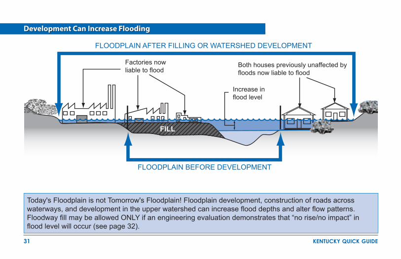
Development Can Increase Flooding
FLOODPLAIN AFTER FILLING OR WATERSHED DEVELOPMENT
FLOODPLAIN BEFORE DEVELOPMENT
FILL
Factories now liable to flood
Both houses previously unaffected by floods now liable to flood
Increase in flood level
Today's Floodplain is not Tomorrow's Floodplain! Floodplain development, construction of roads across waterways, and development in the upper watershed can increase flood depths and alter flow patterns. Floodway fill may be allowed ONLY if an engineering evaluation demonstrates that “no rise/no impact” in flood level will occur (see page 32).

32 kentucky quick guide
Required Floodway “No Rise/No Impact ” Certification
The engineering analysis must be based on technical data obtained from FEMA. Reduce flood risk - don’t build in the Floodway!
Floodways can be dangerous ��because water may flow very fast.
Development is not allowed ��unless there is "no rise" in flood elevations, floodway elevations, and floodway widths are certified.
An engineer must evaluate the ��hydraulic impact of proposed development.
A "no rise/no impact" certification ��is required and must be signed, sealed, and dated by a Professional Engineer licensed in Kentucky.
Check with your community for guidance before you decide to work in a floodway.��
ENGINEERING "NO IMPACT" CERTIFICATION (excerpts)This is to certify that I am a duly qualified engineer licensed to practice in the Commonwealth of Kentucky.It is to further certify that the attached technical data supports the fact that the proposed (Name of Development) will not impact the 100-year flood elevations, floodway elevations and floodway widths on (Name of Stream) at published sections in the Flood Insurance Study (FIS) for (Name of Community) (Dated) and will not impact the 100-year flood elevations, floodway elevations, and floodway widths at unpublished cross-sections in the vicinity of the proposed development._________________________ _______________________(Date) (Signature)

33 kentucky quick guide
What is an Elevation Certificate and How is it Used?
The Elevation Certificate (EC) is a FEMA form. Download a copy ��from http://www.fema.gov/business/nfip/forms.shtm.
When the floodplain has BFEs, the EC must be completed ��and sealed by a surveyor, architect or Professional Engineer authorized by the Commonwealth of Kentucky to certify elevations.
A community official may complete the EC for sites in ��approximate flood zones.
The EC can be used to show that sites are located on natural ��ground above Base Flood Elevation (see page 35).
The EC is used to verify that buildings are elevated properly (see ��page 36).
Insurance agents use the EC to rate/write flood insurance ��policies.
By itself, the EC cannot be used to waive the requirements to get flood insurance. See page 21 for information about Letters of Map Amendment (LOMA).
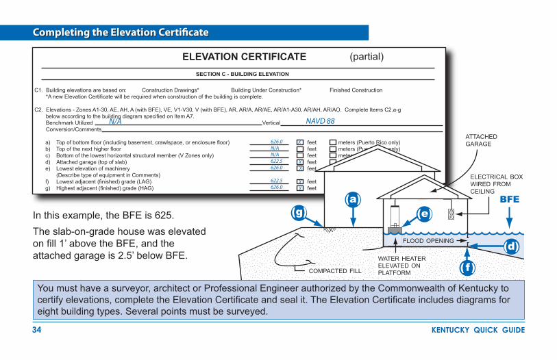
34 kentucky quick guide
Completing the Elevation Certificate
SECTION C - BUILDING ELEVATION
C1. Building elevations are based on: Construction Drawings* Building Under Construction* Finished Construction *A new Elevation Certificate will be required when construction of the building is complete.
C2. Elevations - Zones A1-30, AE, AH, A (with BFE), VE, V1-V30, V (with BFE), AR, AR/A, AR/AE, AR/A1-A30, AR/AH, AR/AO. Complete Items C2.a-g below according to the building diagram specified on Item A7. Benchmark Utilized Vertical Conversion/Comments
a) Top of bottom floor (including basement, crawlspace, or enclosure floor) feet meters (Puerto Rico only)b) Top of the next higher floor feet meters (Puerto Rico only)c) Bottom of the lowest horizontal structural member (V Zones only) feet meters (Puerto Rico only)d) Attached garage (top of slab) feet meters (Puerto Rico only)e) Lowest elevation of machinery feet meters (Puerto Rico only) (Describe type of equipment in Comments)f) Lowest adjacent (finished) grade (LAG) feet meters (Puerto Rico only)g) Highest adjacent (finished) grade (HAG) feet meters (Puerto Rico only)
(g)(a)
(e)
( f )
(d)flood opening
In this example, the BFE is 625.The slab-on-grade house was elevated on fill 1’ above the BFE, and the attached garage is 2.5’ below BFE.
electrical box wired from ceiling
attached garage
You must have a surveyor, architect or Professional Engineer authorized by the Commonwealth of Kentucky to certify elevations, complete the Elevation Certificate and seal it. The Elevation Certificate includes diagrams for eight building types. Several points must be surveyed.
compacted fill
BFE
626.0N/AN/A622.5626.0
622.5626.0
NAVD 88 N/A
X
XX
XX
ELEVATION CERTIFICATE (partial)
water heater elevated on platform

35 kentucky quick guide
Is Your Building Site Higher than the BFE?
If your land is shown on the maps as “in” the floodplain but your building site is higher than the BFE, get a surveyor, architect or Professional Engineer authorized by the Commonwealth of Kentucky to certify elevations, complete the Elevation Certificate and seal it. Submit the EC with an application to FEMA and a LOMA may be issued (See page 21). This is the ONLY way to remove the requirement to purchase flood insurance. Keep the certificate and the LOMA with your deed, it will help future buyers.
Signed and Sealed
lowest natural ground next to building
BFE
Lowest grade
adjacent to
building higher
than BFE Natural ground at your building site IS above the BFE...mandatory flood insurance purchase requirement does not apply
ELEVATION
CERTIFICATE
LOMA
36 kentucky quick guide
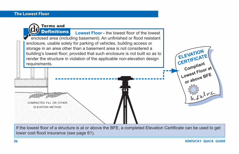
The Lowest Floor
DefinitionsTerms and
Compliant
Lowest Floor at
or above BFE
Lowest Floor - the lowest floor of the lowest enclosed area (including basement). An unfinished or flood resistant enclosure, usable solely for parking of vehicles, building access or storage in an area other than a basement area is not considered a building’s lowest floor; provided that such enclosure is not built so as to render the structure in violation of the applicable non-elevation design requirements.
ELEVATION
CERTIFICATE
If the lowest floor of a structure is at or above the BFE, a completed Elevation Certificate can be used to get lower cost flood insurance (see page 61).
compacted fill or other elevation method

37 kentucky quick guide
How to Elevate Your Floodplain Structure
service equipment such as utilities and electrical circuits above flood level
enclosed area used only for parking, access or limited storage
service equipment such
as utilities and electrical
circuits
lowest floor
flood openings on each wall allow water to flow in and drain out
compacted fill
recommend to at least 10’-15’ beyond house
CAuTION! Enclosures (including crawlspaces) must meet special design requirements (see pages 40 and 41). NOTE: When the walking surface of the lowest floor is at the minimum elevation, under floor utilities are not allowed.
BFE2' min
1'

38 kentucky quick guide
Earthen fill used to raise the ground above the flood elevation must be placed properly so that it does not erode or slump when water rises. For safety and to meet floodplain requirements, floodplain fill should:
Be good clean soil, free of large rocks, construction debris, and woody material (stumps, roots).��
Have graded side slopes not steeper than ��2:1, (one foot of vertical rise for every 2 feet of horizontal extent); flatter slopes are recommended. If steeper than 2 to 1 engineering analysis is required.Be machine compacted to 95 percent of the ��maximum density (determined by a design professional).Have slopes protected against erosion ��(vegetation for “low” velocities, durable materials for “high” velocities determined by a design professional).
Compaction of Floodplain Fill
Your community may ask for certification of the elevation, compaction, slope and slope protection materials. Your engineer or design professional can find more information in FEMA's technical guidance for Letters of Map Revision based on Fill (FEMA Form MT-1) and in NFIP Technical Bulletin #10.
BFE
compacted fill2' min
1'
39 kentucky quick guide
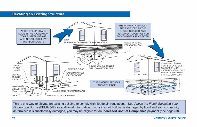
Elevating an Existing Structure
This is one way to elevate an existing building to comply with floodplain regulations. See Above the Flood: Elevating Your Floodprone House (FEMA 347) for additional information. If your insured building is damaged by flood and your community determines it is substantially damaged, you may be eligible for an Increased Cost of Compliance payment (see page 59).
after openings are made in the foundation
walls, steel i-beams are installed below
the floor Joists
THE FOUNDATION WALLS ARE EXTENDED AS THE HOUSE IS RAISED, AND
PERMANENT OPENINGS FOR FLOODWATER ARE CREATED
EXISTING FLOOR JOISTS
ORIGINAL GROUND SURFACE
TEMPORARY STEEL LIFTING BEAM
JACK
I-BEAM OPENINGS FILLED WITH CONCRETE BLOCK
EXISTING FOUNDATION WALL
OPENINGS CUT FOR I-BEAMS
EXISTING FLOOR
TEMPORARY STEEL SUPPORT BEAMS
DEPENDING ON FINAL HEIGHT OF EXTENDED FOUNDATION, AREA UNDER HOUSE MAY ONLY BE USED FOR PARKING, STORAGE OR ACCESSFLOOD LEVEL
NEW PERMANENT OPENINGS FOR FLOODWATERS NEWLY EXTENDED
FOUNDATION WALL
THE FINISHED PROJECT ABOVE THE BFE

40 kentucky quick guide
InformationImportant
Enclosures Below the Lowest Floor
Solid perimeter walls can enclose floodprone areas. A crawlspace is a good way to elevate just a couple of feet. In all cases the following are required: flood openings, utilities elevated to or above the BFE, flood resistant materials and limitations on use of enclosures below the lowest floor. Check with the local permit office for details and restrictions.
at least two flood openings on different sides
lowest floor
no more than 12” above ground
interior ground level at or
above outside grade
CRAWLSPACEBUILDING
BFE
ALTERNATIVE: Engineered openings are acceptable if certified to allow adequate automatic inflow and outflow of floodwaters.
NOTE:Total net area of all total openings is 1 ��sq. in. per sq. ft. of enclosed area.A 25' x 45' building needs 1,125 sq. ��inches of openings.Standard ventilation units used in ��foundation walls must be disabled in the open position to allow water to flow in and out.A standard ventilation unit with screen, ��provides 42 to 65 sq. inches of opening.
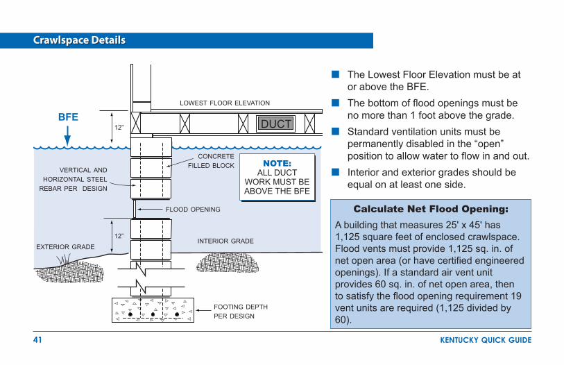
41 kentucky quick guide
Crawlspace Details
The Lowest Floor Elevation must be at ��or above the BFE. The bottom of flood openings must be ��no more than 1 foot above the grade. Standard ventilation units must be ��permanently disabled in the “open” position to allow water to flow in and out.Interior and exterior grades should be ��equal on at least one side.
footing depth per design
interior grade
flood opening
concrete filled block
vertical and horizontal steel
rebar per design
exterior grade
12”
12”
lowest floor elevation
BFE
NOTE:ALL DUCT
WORK MUST BE ABOVE THE BFE
DUCT
Calculate Net Flood Opening:A building that measures 25' x 45' has 1,125 square feet of enclosed crawlspace. Flood vents must provide 1,125 sq. in. of net open area (or have certified engineered openings). If a standard air vent unit provides 60 sq. in. of net open area, then to satisfy the flood opening requirement 19 vent units are required (1,125 divided by 60).
42 kentucky quick guide
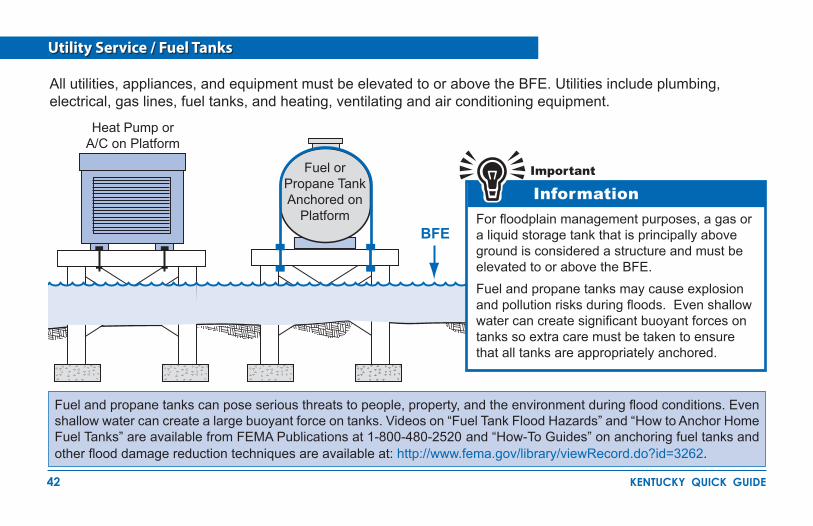
Utility Service / Fuel Tanks
InformationImportant
For floodplain management purposes, a gas or a liquid storage tank that is principally above ground is considered a structure and must be elevated to or above the BFE.Fuel and propane tanks may cause explosion and pollution risks during floods. Even shallow water can create significant buoyant forces on tanks so extra care must be taken to ensure that all tanks are appropriately anchored.
Heat Pump or A/C on Platform
Fuel or Propane Tank Anchored on
PlatformBFE
All utilities, appliances, and equipment must be elevated to or above the BFE. Utilities include plumbing, electrical, gas lines, fuel tanks, and heating, ventilating and air conditioning equipment.
Fuel and propane tanks can pose serious threats to people, property, and the environment during flood conditions. Even shallow water can create a large buoyant force on tanks. Videos on “Fuel Tank Flood Hazards” and “How to Anchor Home Fuel Tanks” are available from FEMA Publications at 1-800-480-2520 and “How-To Guides” on anchoring fuel tanks and other flood damage reduction techniques are available at: http://www.fema.gov/library/viewRecord.do?id=3262.
43 kentucky quick guide
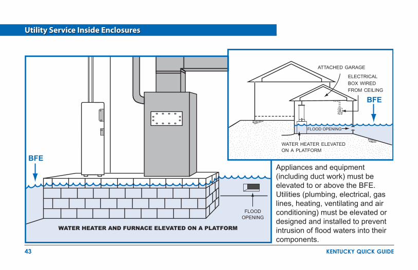
Utility Service Inside Enclosures
electrical box wired from ceiling
attached garage
WATER HEATER AND FURNACE ELEvATED ON A PLATFORM
flood opening
BFE
BFE
FLOOD OPENING
Appliances and equipment (including duct work) must be elevated to or above the BFE. Utilities (plumbing, electrical, gas lines, heating, ventilating and air conditioning) must be elevated or designed and installed to prevent intrusion of flood waters into their components.
water heater elevatedon a platform

44 kentucky quick guide
Move your water heater and furnace out of the basement, or build small elevated platforms for them. If the flood depth is less than two feet, build flood walls or anchor the tanks. Do not store valuables in a floodprone basement. Use flood resistant materials when you repair.
Low Cost Flood Protection for Older Homes
LIVING AREA
BASEMENT
Heating Oil
furnace and other utilities relocated
legs of tank securely anchored in slab
concrete slab

45 kentucky quick guide
Septic Tanks
Post-disaster assessments show that buried septic systems and mounded septic systems in Special Flood Hazard Areas are frequently exposed and/or displaced. In addition to compromising their subsequent use, damage to these systems can release their contents. Consequently, they should be located either outside areas subject to erosion during a base flood, or below the depth of expected erosion.Elevated/mounded septic systems can require significant volumes of fill, which, if placed under or immediately adjacent to buildings, are likely to deflect velocity waters to nearby properties during a storm event.Septic tanks are regulated by the Kentucky Health Department.
plumbing vent
septic tank
leachfield/drainfield
groundwater
46 kentucky quick guide
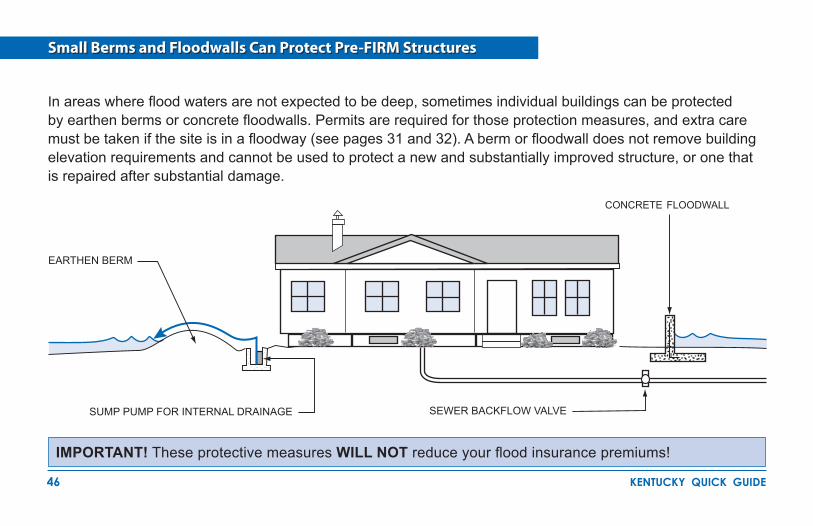
Small Berms and Floodwalls Can Protect Pre-FIRM Structures
IMPORTANT! These protective measures WILL NOT reduce your flood insurance premiums!
In areas where flood waters are not expected to be deep, sometimes individual buildings can be protected by earthen berms or concrete floodwalls. Permits are required for those protection measures, and extra care must be taken if the site is in a floodway (see pages 31 and 32). A berm or floodwall does not remove building elevation requirements and cannot be used to protect a new and substantially improved structure, or one that is repaired after substantial damage.
EARTHEN BERM
SUMP PUMP FOR INTERNAL DRAINAGE SEWER BACKFLOW VALVE
concrete floodwall
47 kentucky quick guide
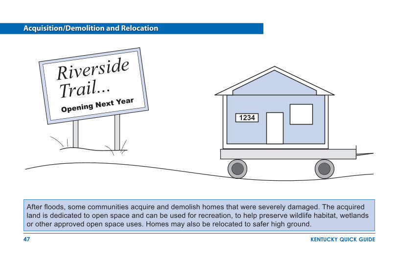
Acquisition/Demolition and Relocation
After floods, some communities acquire and demolish homes that were severely damaged. The acquired land is dedicated to open space and can be used for recreation, to help preserve wildlife habitat, wetlands or other approved open space uses. Homes may also be relocated to safer high ground.
Riverside Trail...Opening Next Year
1234
48 kentucky quick guide
Authorized under Section 404 of the Stafford Act, the Hazard Mitigation Grant Program (HMGP), administered by the Federal Emergency Management Agency (FEMA), provides grants to states, and states provide subgrants to eligible applicants, to implement long-term hazard mitigation measures after a major disaster declaration. The purpose of the program is to reduce the loss of life and property due to natural disasters and to enable mitigation measures to be implemented during the immediate recovery from a disaster.
Participation in HMGP acquisition projects is totally voluntary: jurisdictions are not required to apply for funds and homeowners are not required to sell. Funding is 75% federal share, 25% non-federal share. The program is administered by the Kentucky Division of Emergency Management. Eligible HMGP project applicants include state agencies, county and city governments, certain private non-profit organizations and Indian tribes or authorized tribal organizations. Individuals must work through their local government.
Acquisition and demolition of substantially damaged buildings located in the Special Flood Hazard Area (SFHA) is the first priority for HMGP project funding in Kentucky because it is a permanent mitigation solution to the potential future risk of damage from the 1% or greater annual chance flood. HMGP is the primary funding source to purchase substantially damaged property in the SFHAs.
Communities offer to buy private property at pre-disaster fair market value and clear the land. Properties that have been damaged or even completely destroyed can still be purchased at pre-disaster fair market value. All structures purchased are demolished and the deed to HMGP acquired land must contain a restriction ensuring that the community owned land remains in perpetuity as open space.
Limited funding for acquisitions is also available in other FEMA Mitigation Grant programs. For more information go to: http://www.fema.gov/government/grant/fs_mit_grant_prog.shtm.
Floodprone Property Acquisition Projects

49 kentucky quick guide
Manufactured Homes Deserve Special Attention
Manufactured homes must be anchored to resist flotation, collapse and lateral movement by being tied down in accordance with your community's floodplain ordinance.
secured to built-in frame anchors
elevated utility platform
groundconcrete filled blockmetal rebar rebar each way
concrete footing below frost line
engineered ground anchors
Experience shows that manufactured homes are easily damaged. As little as one foot of water can cause substantial damage.
Dry stacked blocks are not acceptable. They will NOT withstand a flood.
BFE

50 kentucky quick guide
Recreational Vehicles
In a Special Flood Hazard Area, a Recreational Vehicle (RV) must:
Remain on site for fewer than 180 consecutive ��days, or
Be fully licensed and ready for highway use; �� or
Meet the permitting, elevation, and anchoring ��requirements for manufactured homes of the community’s Flood Damage Prevention Ordinance.
RVs that do not meet these conditions must be installed and elevated like a manufactured home, including a permanent foundation and tie-down (See page 49).
InformationImportant
A recreational vehicle is ready for highway use if it is on its wheels or jacking system, is attached to the site only by quick-disconnect type utilities and security devices, and has no permanently attached additions.
Camping near the water? Ask the campground or RV Park operator about flood warnings and plans for safe evacuations.

51 kentucky quick guide
Accessory Structures
Even small buildings are considered “development” and permits or variances with noted conditions are required. CAuTION! Remember...everything inside is likely to get wet when flooding occurs.
Cannot be modified for a ��different use in the future
Must be�� used only for parking or storage
Must have �� flood openings
Must be�� built of flood resistant materials
Must have e�� levated utilities
Must be �� anchored to resist floating
Must �� not be inhabited
Must have�� a documented floor elevation
DefinitionsTerms and
Accessory (Appurtenant) Structure means a structure that is located on the same parcel of land as a principle structure and whose use is incidental to the use of the principal structure. Accessory structures should be no more than a minimal initial investment, may not be used for human habitation, and must be designed to minimize flood damage. Examples include: detached garages, carports, storage sheds, pole barns, and hay sheds.flood openings
elevated utilities
BFE
anchors
Accessory Structures in a Special Flood Hazard Area:
52 kentucky quick guide
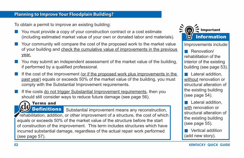
Planning to Improve Your Floodplain Building?
DefinitionsTerms and
InformationImportant
To obtain a permit to improve an existing building:You must provide a copy of your construction contract or a cost estimate ��(including estimated market value of your own or donated labor and materials).Your community will compare the cost of the proposed work to the market value ��of your building and check the cumulative value of improvements in the previous year.You may submit an independent assessment of the market value of the building, ��if performed by a qualified professional.If the cost of the improvement (�� or if the proposed work plus improvements in the past year) equals or exceeds 50% of the market value of the building, you must comply with the Substantial Improvement requirements.If the costs �� do not trigger Substantial Improvement requirements, then you should still consider ways to reduce future damage (see page 56).
Substantial improvement means any reconstruction, rehabilitation, addition, or other improvement of a structure, the cost of which equals or exceeds 50% of the market value of the structure before the start of construction of the improvement. This term includes structures which have incurred substantial damage, regardless of the actual repair work performed (see page 57).
Improvements include:��Renovation/rehabilitation of the interior of the existing building (see page 53).
��Lateral addition, without renovation or structural alteration of the existing building (see page 54).
��Lateral addition, with renovation or structural alteration of the existing building (see page 55).
��Vertical addition (add new story).

53 kentucky quick guide
Substantial Improvement: Renovation Only
InformationImportant
EXISTING BUILDING
EXISTING BUILDING/REHABILITATED BuILDING
Shallow Crawlspace Foundation Raised Fully-Compliant Crawlspace Foundation
Floodplain buildings can be improved, renovated, rehabilitated or altered, but special rules apply.Check with your local permit office and the Division of Water before you begin. It will be easier to do it right the first time.The cost to correct previously cited violations of state or local health, sanitary, or safety codes to provide safe living conditions can be excluded from the cost of renovations.Alteration of a registered historic structure is allowed, as long as it will continue to meet the criteria for listing as a historic structure.
BFE
54 kentucky quick guide
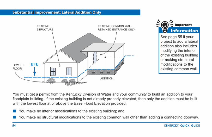
Substantial Improvement: Lateral Addition Only
InformationImportantexisting
structure
lowest floor
addition
existing common wall retained entrance only
BFE
See page 55 if your project to add a lateral addition also includes modifying the interior of the existing building or making structural modifications to the existing common wall.
You must get a permit from the Kentucky Division of Water and your community to build an addition to your floodplain building. If the existing building is not already properly elevated, then only the addition must be built with the lowest floor at or above the Base Flood Elevation provided:
You make no interior modifications to the existing building; and ��
You make no structural modifications to the existing common wall other than adding a connecting doorway.��

55 kentucky quick guide
Substantial Improvement: Addition Plus Other Work
BFE
existing structure on newly elevated foundation
common wall is structurally modified
addition
Your community must prepare an evaluation to determine if all of your proposed work will trigger the Substantial Improvement requirement. Substantial Improvement is triggered if:
The work involves adding a new ��top floor, modifying the interior of the existing building, or structural modifications to the existing common wall (for lateral addition); andThe cost of all proposed work plus ��the cost of improvements in the past year equals or exceeds 50% of the market value of the existing building.
Your community's permit office and the Kentucky Division of Water can help you determine which requirements apply. It is always a good idea to request a preliminary review before you get too far along with your plans.

56 kentucky quick guide
Non-Substantial Improvements
NOTE! Be sure to include ALL proposed work in your initial permit application. If you add more work after the permit is issued, your community will make another evaluation for Substantial Improvement.
Your proposed improvements are "non-substantial" if the cumulative costs of all improvements in the past year are less than 50% of the market value of the building. Although you are not required to bring the existing building into compliance, there are many things you can do to reduce future flood damage. Find out the BFE at your location and consider the following:
Use flood resistant materials, for example tile, closed-cell wall insulation, and polyvinyl wall coverings.��
Raise air conditioning equipment, ��heat pump, furnace, hot water heater, and other appliances on platforms.Install electrical outlets higher ��above the floor.Move ductwork out of crawlspaces.��
Retrofit crawlspaces with flood ��openings.Fill in below-grade crawlspaces/��utility space.
BFE
ac installed above bfe

57 kentucky quick guide
A permit is required to repair substantial damage from any cause - fire, flood, wind, or even a truck running into a building. Check with your permit office to be sure. You will be asked to provide a detailed cost estimate for repairs. The value of donated labor and materials, estimated at current market value, is considered as a cost of the repair.
What About After Damage?
Pre-Damage Building Market Value = $100,000
Cost of Repair = 60%Permit / Elevation Required
Contractor or
Donated Labor
and Materials Floodplain Development Permit1. $2. $3. $4. $5. $
$60,000
SUBSTANTIAL IMPROVEMENTELEVATEABOVE BFE

58 kentucky quick guide
Residential Substantial Damage Estimator
Communities participating in the National Flood Insurance Program (NFIP) often have difficulty determining whether buildings are substantially damaged. This difficulty is magnified after a major flood or other disaster where a large number
of buildings have been damaged and there is a need to provide timely substantial damage determinations so that reconstruction can begin. Buildings located in a Special Flood Hazard Area (SFHA) that are determined to be substantially damaged/improved, must be brought into compliance with the minimum requirements of the community’s NFIP compliant floodplain management laws or ordinances. The regulations may require a residential building to be elevated, resulting in additional repair/reconstruction costs for the homeowner. FEMA has developed a computer program, called the Residential Substantial Damage Estimator (RSDE), to assist state and local officials in estimating building value and damage costs for both single family and manufactured homes. This computer application is based on regulatory requirements of the NFIP and is intended to be used in conjunction with an industry accepted residential cost estimating guide.The program consists of step-by-step directions, with accompanying illustrations
showing where data regarding the pre-disaster fair market value of a structure, the cost of repair and percentage of damage to components of a structure can be entered. Based on the information entered, the program computes the overall damage percentage.A new version of the software called the Substantial Damage Estimator, which includes estimating tools for non-residential and residential buildings is scheduled for release in June 2009.
Call FEMA Publications at 1-800-480-2520 to order your free copy of the RSDE software.

59 kentucky quick guide
Paying for Post Flood Compliance - ICC
Detailed information on ICC is available at http://www.fema.gov/plan/prevent/floodplain/ICC.shtm and in the FEMA publication Interim Guidance for State and Local Officials - Increased Cost of Compliance Coverage (FEMA 301).
Increased Cost of Compliance, or ICC, coverage is part of most Standard Flood Insurance Policies. Claims for ICC benefits are filed separately from your claim for contents or building loss. If eligible, you can collect up to $30,000 to help cover the cost of bringing your home or business into compliance with current flood damage prevention ordinances. You are eligible to file for ICC if your property is in a SFHA and if your community Floodplain Administrator determines one of the following:
Your property is “substantially damaged” by flooding. This means that your community says the cost to repair your flooded building is 50 percent or more of its pre-disaster market value.Your property sustained “repetitive damage.” This term applies to homes or businesses that were damaged by flooding twice in the past 10 years, where the cost of repairing the flood damage, on average, equaled or exceeded 25 percent of the property market value at the time of each flood. Also, there must have been flood insurance claim payments for each of the two flood losses, and the community’s
flood damage prevention ordinance must have a repetitive loss provision.ICC funding can be used to elevate or demolish homes, relocate them to higher ground, or floodproofing of non-residential structures. Also, when participating in a community sponsored, FEMA funded mitigation project, the policyholder may assign ICC benefits to the community to integrate into the project. The community then becomes responsible for submitting all of the appropriate paperwork.
Floodproof
Demolish
Relocate
Elevate
60 kentucky quick guide
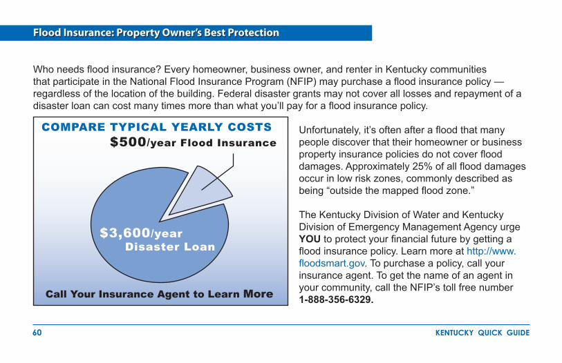
Who needs flood insurance? Every homeowner, business owner, and renter in Kentucky communities that participate in the National Flood Insurance Program (NFIP) may purchase a flood insurance policy — regardless of the location of the building. Federal disaster grants may not cover all losses and repayment of a disaster loan can cost many times more than what you’ll pay for a flood insurance policy.
Unfortunately, it’s often after a flood that many people discover that their homeowner or business property insurance policies do not cover flood damages. Approximately 25% of all flood damages occur in low risk zones, commonly described as being “outside the mapped flood zone.”
The Kentucky Division of Water and Kentucky Division of Emergency Management Agency urge YOU to protect your financial future by getting a flood insurance policy. Learn more at http://www.floodsmart.gov. To purchase a policy, call your insurance agent. To get the name of an agent in your community, call the NFIP’s toll free number 1-888-356-6329.
Flood Insurance: Property Owner’s Best Protection
Call Your Insurance Agent to Learn More
COMPARE TYPICAL YEARLY COSTS $500/year Flood Insurance
$3,600/year Disaster Loan
61 kentucky quick guide
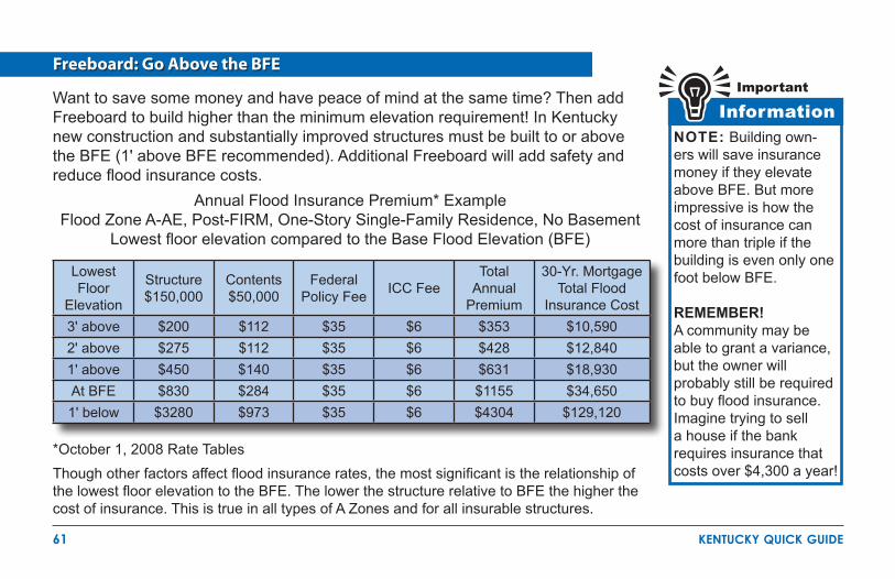
Freeboard: Go Above the BFE
Want to save some money and have peace of mind at the same time? Then add Freeboard to build higher than the minimum elevation requirement! In Kentucky new construction and substantially improved structures must be built to or above the BFE (1' above BFE recommended). Additional Freeboard will add safety and reduce flood insurance costs.
*October 1, 2008 Rate TablesThough other factors affect flood insurance rates, the most significant is the relationship of the lowest floor elevation to the BFE. The lower the structure relative to BFE the higher the cost of insurance. This is true in all types of A Zones and for all insurable structures.
Annual Flood Insurance Premium* ExampleFlood Zone A-AE, Post-FIRM, One-Story Single-Family Residence, No Basement
Lowest floor elevation compared to the Base Flood Elevation (BFE)
InformationImportant
NOTE: Building own-ers will save insurance money if they elevate above BFE. But more impressive is how the cost of insurance can more than triple if the building is even only one foot below BFE.
REMEMBER!A community may be able to grant a variance, but the owner will probably still be required to buy flood insurance. Imagine trying to sell a house if the bank requires insurance that costs over $4,300 a year!
Lowest Floor
Elevation
Structure $150,000
Contents$50,000
Federal Policy Fee ICC Fee
Total Annual
Premium
30-Yr. Mortgage Total Flood
Insurance Cost3' above $200 $112 $35 $6 $353 $10,5902' above $275 $112 $35 $6 $428 $12,8401' above $450 $140 $35 $6 $631 $18,930At BFE $830 $284 $35 $6 $1155 $34,6501' below $3280 $973 $35 $6 $4304 $129,120
62 kentucky quick guide
Flood Zones
Flood zones are geographic areas that the Federal Emergency Management Agency (FEMA) has defined according to varying levels of flood risk. These zones are depicted on a community’s Flood Hazard Boundary Map (FHBM) or FIRM and Digital FIRMs (DFIRMs) if the DFIRM is available. Each zone reflects the severity or type of flooding in the area.
High Risk Areas: All A Zones – The area that located within the one-percent annual chance floodplain (100-year floodplain) identified as a Special Flood Hazard Areas on Flood Insurance Rate Maps. Flood insurance is available to all property owners and renters. Lenders require mandatory purchase of flood insurance.
Moderate to Low Risk Areas: Zones B (moderate), C and X (low) – Areas located outside the one-percent annual chance floodplain (100-year floodplain). Includes areas protected from flood by certified levees. Area is higher than base flood elevation. Lower-cost flood insurance is available to all property owners and renters. Mandatory flood insurance purchase requirements do not apply.
Undetermined Risk Areas: Zone D – Unstudied areas of undetermined but possible flood hazards. Base flood elevations not available. Flood insurance is available to all property owners and renters. Mandatory flood insurance purchase requirements do not apply.
NFIP Flood Insurance is not available to residents of communities that do not participate in the NFIP.
63 kentucky quick guide
Useful Resources
Common Acronyms
BFE – Base Flood ElevationCLOMA – Conditional Letter of Map AmendmentCLOMR – Conditional Letter of Map RevisionCLOMR-F – Conditional Letter of Map Revision based on FillCRS – Community Rating SystemDFIRM - Digital Flood Insurance Rate MapEC – Elevation CertificateKDEM – Kentucky Division of Emergency ManagementFEMA – Federal Emergency Management AgencyKAMM – Kentucky Association of Mitigation ManagersFHBM – Flood Hazard Boundary MapFIRM – Flood Insurance Rate MapFIS – Flood Insurance StudyICC – Increased Cost of ComplianceLOMA – Letter of Map AmendmentLOMC – Letter of Map ChangeLOMR – Letter of Map RevisionLOMR-F – Letter of Map Revision based on FillNFIP – National Flood Insurance ProgramRSDE – Residential Substantial Damage EstimatorSFHA – Special Flood Hazard Area
Internet Links
Kentucky Division of Waterhttp://www.water.ky.gov
Kentucky Division of Emergency Managementhttp://kyem.ky.gov/
Kentucky Association of Mitigation Managershttp://www.kymitigation.org
Family Disaster Planninghttp://www.redcross.org/http://www.fema.gov/areyouready/
Repairing Your Flooded Home, ARC and FEMAhttp://www.fema.gov/library/viewRecord.do?id=1418
NFIP Floodplain Management Requirements A Study Guide and Desk Reference for Local Officials http://www.floods.org/Certification/FEMA_480.asp
NFIP Publicationshttp://www.fema.gov/business/nfip/libfacts.shtm
FEMA Elevation Certificatehttp://www.fema.gov/business/nfip/forms.shtm
NFIP Technical Bulletinshttp://www.fema.gov/plan/prevent/floodplain/techbul.shtm
64 kentucky quick guide
For information and advice on permits, call your community’s building permit office or planning department.��
For advice on permitting and managing floodplains, contact the State NFIP Coordinator at 1-502-564-3410. ��
For information about workshops, training and conferences, contact the State NFIP Coordinator at ��1-502-564-3410.To order FEMA flood maps, call FEMA’s Map Service Center at 1-800-358-9616 or order online at ��http://www.msc.fema.gov/.To check the status of map change requests, learn more about flood maps, map modernization, and other ��aspects of flood hazard mapping go to http://www.fema.gov/plan/prevent/fhm/index.shtm.FEMA’s on-line publications can be found in the FEMA Virtual Library. Many are posted in the Portable ��Document Format (PDF). Go to http://www.fema.gov/library/ for more information. You can order printed copies of FEMA publications from FEMA Publications at 1-800-480-2520.To learn about flood risk and the importance of taking steps to financially protect homes and businesses ��from flood damage go to http://www.floodsmart.gov. To learn about flood insurance, call your insurance agent. Most insurance companies can write an NFIP ��policy for you. Call the National Flood Insurance Program’s toll free number, 1-888-356-6329, to get the name of an agent in your area who writes flood insurance.Online training in completing the Elevation Certificate is available at: �� http://training.nfipstat.com/ecsurveyor/.
Want to Learn More?

This Quick Guide may be downloaded from the Kentucky Division of Water website at:
http://www.water.ky.govor
the Kentucky Association of Mitigation Managers at website at:http://www.kymitigation.org