
Fisheries Impact Assessment Woolston Weir - River...
93
Fisheries Impact Assessment Woolston Weir - River Mersey Client: Peel Energy September 2012 Adam Fryer BSc, MSc Pete Kibel BSc, MSc, MIFM
Transcript of Fisheries Impact Assessment Woolston Weir - River...
Fisheries Impact Assessment
Woolston Weir - River Mersey
Client: Peel Energy
September 2012
Adam Fryer BSc, MSc
Pete Kibel BSc, MSc, MIFM

FISHTEK CONSULTING Woolston Weir Fisheries Impact Assessment
Fishtek Consulting. 1 Shinners Bridge, Webbers Way, Dartington, Totnes, TQ96JY
www.fishtek-consulting.co.uk Tel. 01803866680 Fax. 01803862610
Report title: Woolston Weir Hydropower Proposal Fisheries Impact
Assessment
Status: Final Draft
Date: 13th
September 2012
Project Code: WWHPFIA/13/09/2012/AF
Client: Peel Energy
Lead Author: Adam Fryer
QC: Pete Kibel
Copyright. Fishtek Consulting Ltd.
This report has been prepared for the exclusive use of the commissioning party.
Fishtek Consulting Ltd. has used due skill, care and diligence in the preparation of this report.
No liability is accepted by Fishtek Consulting Ltd. for the use and or application of the
contents of the report.
FISHTEK CONSULTING Woolston Weir Fisheries Impact Assessment
Fishtek Consulting. 1 Shinners Bridge, Webbers Way, Dartington, Totnes, TQ96JY
www.fishtek-consulting.co.uk Tel. 01803866680 Fax. 01803862610
Executive summary
Peel Energy are proposing to install a hydro power scheme at Woolston weir on the River
Mersey. The scheme includes three Archimedean screw turbines, each with a maximum rated
flow of 11 m3/s, as well as a 5.4 m wide Larinier fish pass on the right hand bank to replace
the current pool and traverse pass. Fishtek consulting have been commissioned to assess the
impacts of the proposed scheme on the fisheries ecology within the weir pool and the area
downstream, with a particular focus on the potential effects to dissolved oxygen (DO)
concentrations.
Dissolved oxygen data was recorded above and below Woolston weir including the area up to
1.5 km downstream. DO measurements were also taken at Howley weir and Ashton weir,
located 6 km downstream and 20 km upstream of Woolston weir respectively. This data was
used along with historical data to predict the effect that the proposed scheme would have on
DO concentrations below Woolston weir at different Hands-Off Flows (HOF) regimes.
Additionally, a survey was conducted to assess the hydrology and morphology of the weir
pool and the area immediately downstream. Depths and velocities were measured across a
series of transects and sediment samples taken. Substrate types were classified for each
sampling location and the predominant benthic composition was identified. The data was
used to assess how the installation may result in morphological and hydrological changes
within the weir pool and how this may in turn impact fish habitat.
It was found that although the proposed scheme will result in slight changes in the
hydrological profile of the weir pool, it is unlikely that this would impact upon the
availability of rheophilic or phytophilic spawning habitat. This is mainly due to the limited
extent of spawning habitat at the site, with only the bankside areas offering some phytophilic
spawning potential.
Woolston weir re-oxygenates water and in recent years DO concentrations below the weir
have remained above the critical threshold for fish and other sensitive taxa, (generally
considered to be 5 mg/l). These levels are sustained as far downstream as Howley weir. It is
likely that a low HOF (below Q95) could have a negative impact on DO concentrations
downstream of Woolston weir, increasing the risk of levels falling below this threshold. It is
therefore recommended that either a HOF of Q95 (8.91 m3/s) is adopted, or if a lower HOF is
used, monitoring and mitigation should be installed to ensure that DO concentrations are
maintained above this threshold. Suitable mitigation could include the use of artificial
aeration devices, DO data loggers and turbine off protocols.
It is likely that the weir pools are used by fish as a refuge during periods of high temperature
and low DO concentration. It is therefore essential that a reasonable amount of flow is
maintained over the side weirs as a part of the schemes HOF. In order to frequently replenish
water within the weir pools and maintain DO concentrations, a flow of at least 1 m3/s over
each side weir is recommended at all times.

FISHTEK CONSULTING Woolston Weir Fisheries Impact Assessment
Fishtek Consulting. 1 Shinners Bridge, Webbers Way, Dartington, Totnes, TQ96JY
www.fishtek-consulting.co.uk Tel. 01803866680 Fax. 01803862610
The proposed Larinier fish pass will significantly improve fish passage at the site. It is
recommended that as much water as possible is discharged through the pass in order to
achieve high attraction flows. Assuming that a lower HOF is used (in combination with a DO
mitigation plan), flow in the fish pass should be 2.11 m3/s. This gives a depth in the pass of
0.32 m and a velocity of 1.34 m/s across the HOF, therefore suitable for use by salmonids
and coarse fish.
A Q95 HOF presents little risk from a fisheries perspective, although a lower HOF may be
possible providing measures are taken to mitigate against the potential impact on downstream
DO concentrations. A HOF below 4.11 m3/s presents an increased risk since less water will
be available for the fish pass and side weirs.
FISHTEK CONSULTING Woolston Weir Fisheries Impact Assessment
Fishtek Consulting. 1 Shinners Bridge, Webbers Way, Dartington, Totnes, TQ96JY
www.fishtek-consulting.co.uk Tel. 01803866680 Fax. 01803862610
Content Page
1. Introduction………………………………………………………..... 1
1.1. Site details ……….…………………………………………………………… 1
1.2. Site flows ……………...……………………………………………………… 2
1.3. Proposed hydro scheme……………………………………………………… 3
1.4. Fisheries ecology within the River Mersey at Woolston weir .………….... 5
2. Methods ……………………………………………………………… 10
2.1. Assessment of the general impacts of a hydropower
Installation at Woolston weir…...………………………………………….. 10
2.2. Assessment of fish spawning and juvenile habitat availability…………… 10
2.2.1 Assessment of the benthic composition………………………………... 11
2.2.2 Assessment of overall habitat quality………………………………..... 12
2.3 Assessment of the potential impacts of the proposed scheme on
dissolved oxygen concentrations……………………………………………… 14
3. Results………………………………………………………………... 15
3.1. Potential impacts on fish as a result of downstream passage through the
turbine……………………………………………….....………………………...... 15
3.2. Changes in oxygen levels as a result of the turbine installation…………… 17
3.2.1 Measured oxygen concentrations………………………………………. 17
3.2.2 Historical DO concentrations………………………………………....... 21
3.2.3 Predicted Oxygen concentrations as a result of
turbine installation………………………………………………………. 22
3.3. Morphology and hydrology of the weir pool………………………………… 26
3.4. Changes in the weir pool hydrology as a result of turbine installation….... 27
3.5. Benthic composition and substrate availability within the weir pool…....... 29
3.6. Spawning habitat availability within the weir pool………………………….. 30
3.7. Changes to spawning habitat availability within the weir pool as
result of turbine installation…………………………………………………… 31
3.8 Fish passage…………………………………………………………………….. 32
4. Conclusions and recommendations………………………………… 34
5. References……………………………………………………………. 36
FISHTEK CONSULTING Woolston Weir Fisheries Impact Assessment
Fishtek Consulting. 1 Shinners Bridge, Webbers Way, Dartington, Totnes, TQ96JY
www.fishtek-consulting.co.uk Tel. 01803866680 Fax. 01803862610 1
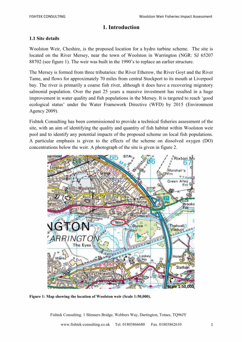
1. Introduction
1.1 Site details
Woolston Weir, Cheshire, is the proposed location for a hydro turbine scheme. The site is
located on the River Mersey, near the town of Woolston in Warrington (NGR: SJ 65207
88702 (see figure 1). The weir was built in the 1990’s to replace an earlier structure.
The Mersey is formed from three tributaries: the River Etherow, the River Goyt and the River
Tame, and flows for approximately 70 miles from central Stockport to its mouth at Liverpool
bay. The river is primarily a coarse fish river, although it does have a recovering migratory
salmonid population. Over the past 25 years a massive investment has resulted in a huge
improvement in water quality and fish populations in the Mersey. It is targeted to reach ‘good
ecological status’ under the Water Framework Directive (WFD) by 2015 (Environment
Agency 2009).
Fishtek Consulting has been commissioned to provide a technical fisheries assessment of the
site, with an aim of identifying the quality and quantity of fish habitat within Woolston weir
pool and to identify any potential impacts of the proposed scheme on local fish populations.
A particular emphasis is given to the effects of the scheme on dissolved oxygen (DO)
concentrations below the weir. A photograph of the site is given in figure 2.
Figure 1: Map showing the location of Woolston weir (Scale 1:50,000).
Scale 1:50,000
FISHTEK CONSULTING Woolston Weir Fisheries Impact Assessment
Fishtek Consulting. 1 Shinners Bridge, Webbers Way, Dartington, Totnes, TQ96JY
www.fishtek-consulting.co.uk Tel. 01803866680 Fax. 01803862610 2
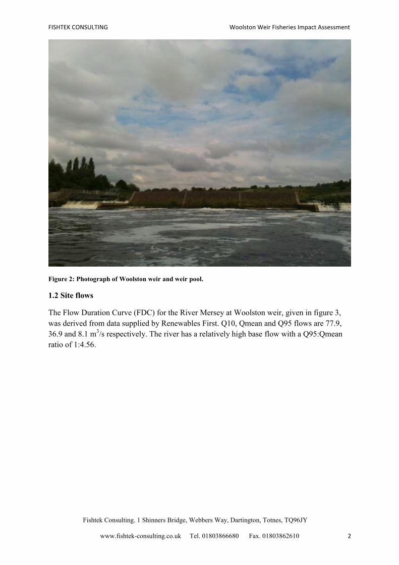
Figure 2: Photograph of Woolston weir and weir pool.
1.2 Site flows
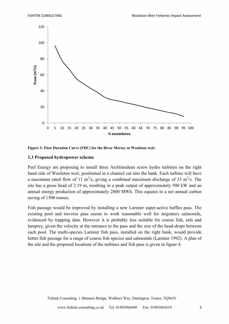
The Flow Duration Curve (FDC) for the River Mersey at Woolston weir, given in figure 3,
was derived from data supplied by Renewables First. Q10, Qmean and Q95 flows are 77.9,
36.9 and 8.1 m3/s respectively. The river has a relatively high base flow with a Q95:Qmean
ratio of 1:4.56.
FISHTEK CONSULTING Woolston Weir Fisheries Impact Assessment
Fishtek Consulting. 1 Shinners Bridge, Webbers Way, Dartington, Totnes, TQ96JY
www.fishtek-consulting.co.uk Tel. 01803866680 Fax. 01803862610 3
Figure 3: Flow Duration Curve (FDC) for the River Mersey at Woolston weir.
1.3 Proposed hydropower scheme
Peel Energy are proposing to install three Archimedean screw hydro turbines on the right
hand side of Woolston weir, positioned in a channel cut into the bank. Each turbine will have
a maximum rated flow of 11 m3/s, giving a combined maximum discharge of 33 m
3/s. The
site has a gross head of 2.19 m, resulting in a peak output of approximately 500 kW and an
annual energy production of approximately 2800 MWh. This equates to a net annual carbon
saving of 1500 tonnes.
Fish passage would be improved by installing a new Larinier super-active baffles pass. The
existing pool and traverse pass seems to work reasonable well for migratory salmonids,
evidenced by trapping data. However it is probably less suitable for coarse fish, eels and
lamprey, given the velocity at the entrance to the pass and the size of the head-drops between
each pool. The multi-species Larinier fish pass, installed on the right bank, would provide
better fish passage for a range of coarse fish species and salmonids (Larinier 1992). A plan of
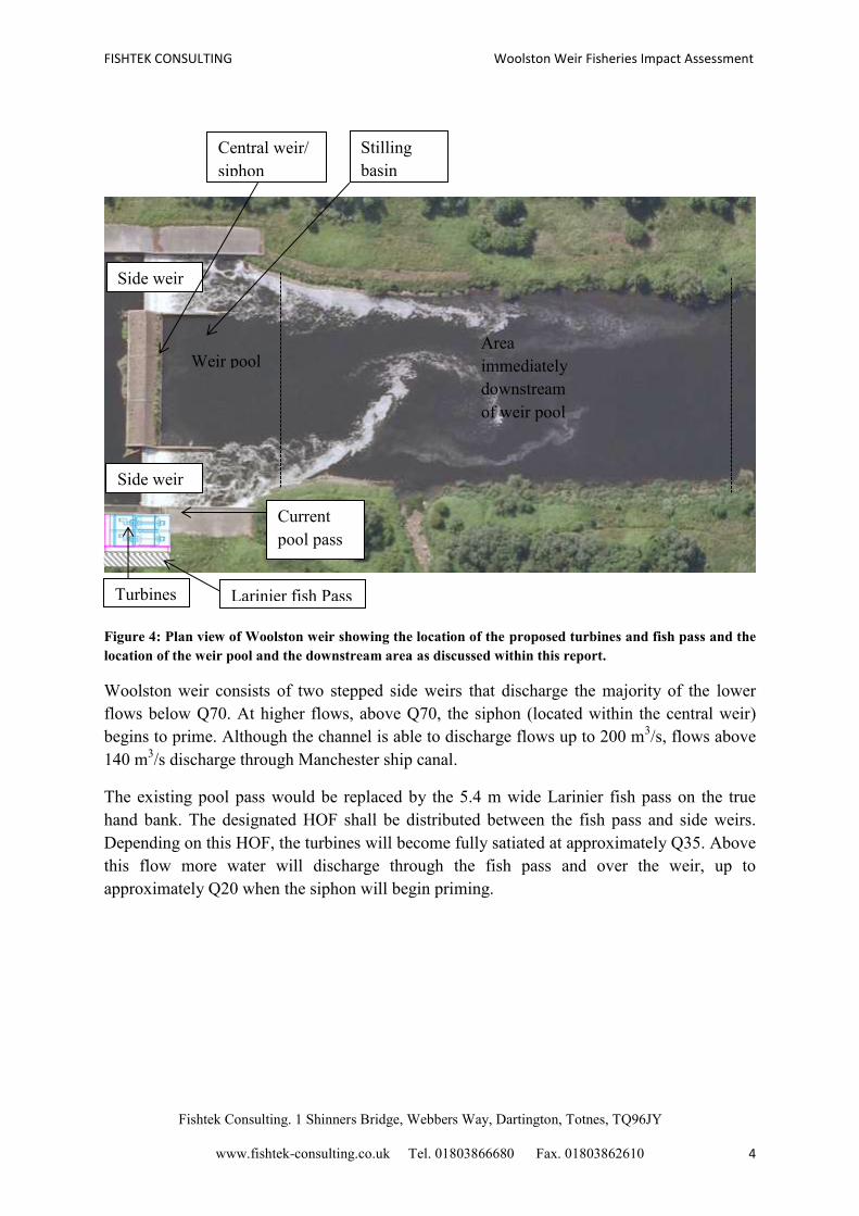
the site and the proposed locations of the turbines and fish pass is given in figure 4.
0
20
40
60
80
100
120
0 5 10 15 20 25 30 35 40 45 50 55 60 65 70 75 80 85 90 95 100
FLo
w (
m3 /
s)
% exceedance
FISHTEK CONSULTING Woolston Weir Fisheries Impact Assessment
Fishtek Consulting. 1 Shinners Bridge, Webbers Way, Dartington, Totnes, TQ96JY
www.fishtek-consulting.co.uk Tel. 01803866680 Fax. 01803862610 4
Figure 4: Plan view of Woolston weir showing the location of the proposed turbines and fish pass and the
location of the weir pool and the downstream area as discussed within this report.
Woolston weir consists of two stepped side weirs that discharge the majority of the lower
flows below Q70. At higher flows, above Q70, the siphon (located within the central weir)
begins to prime. Although the channel is able to discharge flows up to 200 m3/s, flows above
140 m3/s discharge through Manchester ship canal.
The existing pool pass would be replaced by the 5.4 m wide Larinier fish pass on the true
hand bank. The designated HOF shall be distributed between the fish pass and side weirs.
Depending on this HOF, the turbines will become fully satiated at approximately Q35. Above
this flow more water will discharge through the fish pass and over the weir, up to
approximately Q20 when the siphon will begin priming.
Turbines Larinier fish Pass
Side weir
Central weir/
siphon
Current
pool pass
Weir pool Area
immediately
downstream
of weir pool
Stilling
basin
Side weir
FISHTEK CONSULTING Woolston Weir Fisheries Impact Assessment
Fishtek Consulting. 1 Shinners Bridge, Webbers Way, Dartington, Totnes, TQ96JY
www.fishtek-consulting.co.uk Tel. 01803866680 Fax. 01803862610 5
1.4 Fisheries Ecology at Woolston weir
The River Mersey has a history of chronic pollution from industrial discharges and raw
sewage, resulting in very poor water quality. The once thriving fishery became an ecological
‘dead zone’ and by the 1940’s all commercial fishing in the tidal reaches had ceased
(Environment Agency 2008). The River Mersey had become the most polluted river in
Europe. In addition, changes in river morphology led to the decline and fragmentation of any
remaining available fish habitat, resulting in further declines of the fish population.
Over the past 25 years over one billion pounds has been invested in cleaning up the River
Mersey, in an attempt to improve river health and fish populations. Water quality has been
vastly improved, most evidenced by the recovering fish populations. Although coarse fish
species have seen the quickest recovery, a recent study by the Environment Agency identified
a modest and recovering population of Atlantic salmon (Environment Agency- Salmon
behaviour in the Mersey Catchment), a species that was declared locally extinct up until the
mid-1990s.
The Environment Agency frequently carries out hydroacoustic surveys along the Mersey as
part of a routine monitoring programme. Fisheries data for the Mersey, in particular
Woolston weir was requested from the Environment Agency. Although hydroacoustic data
provides a quantitative assessment of fish density within a given area, it does not identify
individual species. Local species assemblages have been identified from rod catch data
compiled by local fishing clubs and trap data from Woolston fish pass.
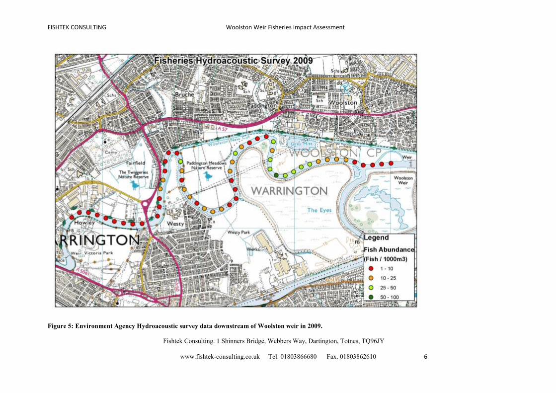
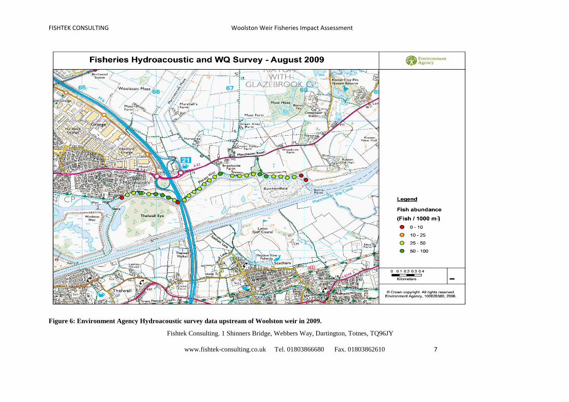
Figure 5 and 6 displays fish abundance from Howley to Bolin Point (approximately an 8 Km
stretch of river) in 2009 as recorded by the Environment Agency’s hydroacoustic surveys.
Fish are found along the length of this catchment area, although at different densities. Fish
are typically at low densities (1-10 individuals/1000 m3) at the area immediately downstream
of Woolston weir. Upstream of the weir and beyond the sluice densities are generally higher,
with approximately 25-50 individuals/1000 m3.
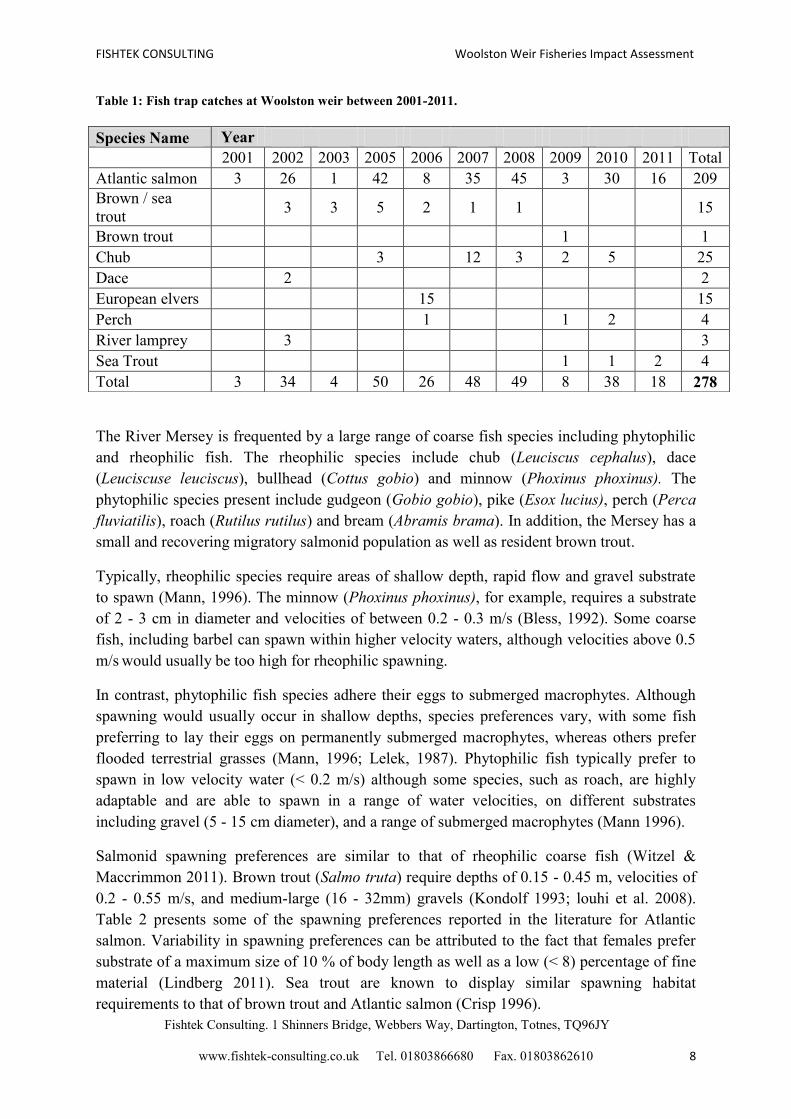
In addition to hydroacoustic surveys, a fish trap above Woolston fish pass is used to assess
the abundance of Atlantic salmon within the Mersey. Catches in the trap from 2001-2011 are
displayed in table 1. There are large inter annual variations in the numbers of salmon using
the pass. This may be as a result of different trapping efforts from year to year, or even an
indication of a small and sensitive population. Although the pool and traverse pass on the
weir was primarily designed for migratory salmonids, there is evidence of coarse fish, eels
and lamprey using the pass.
FISHTEK CONSULTING Woolston Weir Fisheries Impact Assessment
Fishtek Consulting. 1 Shinners Bridge, Webbers Way, Dartington, Totnes, TQ96JY
www.fishtek-consulting.co.uk Tel. 01803866680 Fax. 01803862610 6
Figure 5: Environment Agency Hydroacoustic survey data downstream of Woolston weir in 2009.
FISHTEK CONSULTING Woolston Weir Fisheries Impact Assessment
Fishtek Consulting. 1 Shinners Bridge, Webbers Way, Dartington, Totnes, TQ96JY
www.fishtek-consulting.co.uk Tel. 01803866680 Fax. 01803862610 7
Figure 6: Environment Agency Hydroacoustic survey data upstream of Woolston weir in 2009.
FISHTEK CONSULTING Woolston Weir Fisheries Impact Assessment
Fishtek Consulting. 1 Shinners Bridge, Webbers Way, Dartington, Totnes, TQ96JY
www.fishtek-consulting.co.uk Tel. 01803866680 Fax. 01803862610 8
Table 1: Fish trap catches at Woolston weir between 2001-2011.
The River Mersey is frequented by a large range of coarse fish species including phytophilic
and rheophilic fish. The rheophilic species include chub (Leuciscus cephalus), dace
(Leuciscuse leuciscus), bullhead (Cottus gobio) and minnow (Phoxinus phoxinus). The
phytophilic species present include gudgeon (Gobio gobio), pike (Esox lucius), perch (Perca
fluviatilis), roach (Rutilus rutilus) and bream (Abramis brama). In addition, the Mersey has a
small and recovering migratory salmonid population as well as resident brown trout.
Typically, rheophilic species require areas of shallow depth, rapid flow and gravel substrate
to spawn (Mann, 1996). The minnow (Phoxinus phoxinus), for example, requires a substrate
of 2 - 3 cm in diameter and velocities of between 0.2 - 0.3 m/s (Bless, 1992). Some coarse
fish, including barbel can spawn within higher velocity waters, although velocities above 0.5
m/s would usually be too high for rheophilic spawning.
In contrast, phytophilic fish species adhere their eggs to submerged macrophytes. Although
spawning would usually occur in shallow depths, species preferences vary, with some fish
preferring to lay their eggs on permanently submerged macrophytes, whereas others prefer
flooded terrestrial grasses (Mann, 1996; Lelek, 1987). Phytophilic fish typically prefer to
spawn in low velocity water (< 0.2 m/s) although some species, such as roach, are highly
adaptable and are able to spawn in a range of water velocities, on different substrates
including gravel (5 - 15 cm diameter), and a range of submerged macrophytes (Mann 1996).
Salmonid spawning preferences are similar to that of rheophilic coarse fish (Witzel &
Maccrimmon 2011). Brown trout (Salmo truta) require depths of 0.15 - 0.45 m, velocities of
0.2 - 0.55 m/s, and medium-large (16 - 32mm) gravels (Kondolf 1993; louhi et al. 2008).
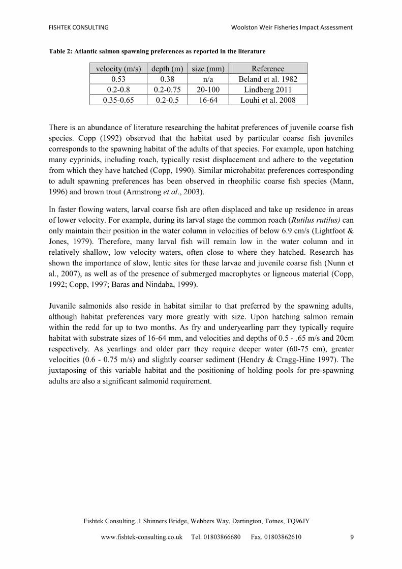
Table 2 presents some of the spawning preferences reported in the literature for Atlantic
salmon. Variability in spawning preferences can be attributed to the fact that females prefer
substrate of a maximum size of 10 % of body length as well as a low (< 8) percentage of fine
material (Lindberg 2011). Sea trout are known to display similar spawning habitat
requirements to that of brown trout and Atlantic salmon (Crisp 1996).
Species Name Year
2001 2002 2003 2005 2006 2007 2008 2009 2010 2011 Total
Atlantic salmon 3 26 1 42 8 35 45 3 30 16 209
Brown / sea
trout 3 3 5 2 1 1
15
Brown trout
1
1
Chub
3
12 3 2 5
25
Dace
2
2
European elvers
15
15
Perch
1
1 2
4
River lamprey
3
3
Sea Trout
1 1 2 4
Total 3 34 4 50 26 48 49 8 38 18 278
FISHTEK CONSULTING Woolston Weir Fisheries Impact Assessment
Fishtek Consulting. 1 Shinners Bridge, Webbers Way, Dartington, Totnes, TQ96JY
www.fishtek-consulting.co.uk Tel. 01803866680 Fax. 01803862610 9
Table 2: Atlantic salmon spawning preferences as reported in the literature
velocity (m/s) depth (m) size (mm) Reference
0.53 0.38 n/a Beland et al. 1982
0.2-0.8 0.2-0.75 20-100 Lindberg 2011
0.35-0.65 0.2-0.5 16-64 Louhi et al. 2008
There is an abundance of literature researching the habitat preferences of juvenile coarse fish
species. Copp (1992) observed that the habitat used by particular coarse fish juveniles
corresponds to the spawning habitat of the adults of that species. For example, upon hatching
many cyprinids, including roach, typically resist displacement and adhere to the vegetation
from which they have hatched (Copp, 1990). Similar microhabitat preferences corresponding
to adult spawning preferences has been observed in rheophilic coarse fish species (Mann,
1996) and brown trout (Armstrong et al., 2003).
In faster flowing waters, larval coarse fish are often displaced and take up residence in areas
of lower velocity. For example, during its larval stage the common roach (Rutilus rutilus) can
only maintain their position in the water column in velocities of below 6.9 cm/s (Lightfoot &
Jones, 1979). Therefore, many larval fish will remain low in the water column and in
relatively shallow, low velocity waters, often close to where they hatched. Research has
shown the importance of slow, lentic sites for these larvae and juvenile coarse fish (Nunn et
al., 2007), as well as of the presence of submerged macrophytes or ligneous material (Copp,
1992; Copp, 1997; Baras and Nindaba, 1999).
Juvanile salmonids also reside in habitat similar to that preferred by the spawning adults,
although habitat preferences vary more greatly with size. Upon hatching salmon remain
within the redd for up to two months. As fry and underyearling parr they typically require
habitat with substrate sizes of 16-64 mm, and velocities and depths of 0.5 - .65 m/s and 20cm
respectively. As yearlings and older parr they require deeper water (60-75 cm), greater
velocities (0.6 - 0.75 m/s) and slightly coarser sediment (Hendry & Cragg-Hine 1997). The
juxtaposing of this variable habitat and the positioning of holding pools for pre-spawning
adults are also a significant salmonid requirement.
FISHTEK CONSULTING Woolston Weir Fisheries Impact Assessment
Fishtek Consulting. 1 Shinners Bridge, Webbers Way, Dartington, Totnes, TQ96JY
www.fishtek-consulting.co.uk Tel. 01803866680 Fax. 01803862610 10
2. Methods
2.1 Assessment of the general impacts of a hydropower installation at Woolston weir
Published literature, data from previous studies and site specific information were used to
assess the potential impact of the hydropower installation at Woolston weir. The following
were considered:
- Impact of the turbine installation on dissolved oxygen concentrations within the 7 Km reach
downstream of Woolston weir. .
- Impact of the turbine installation on the general hydrology of the weir pool.
- Impact of the turbine installation on the availability of fish spawning habitat within the weir
pool.
2.2 Assessment of fish spawning and juvenile habitat availability
The site was visited by the authors on 25/07/2012 when river flow was at approximately Q80,
estimated from the river level gauge at Westy Gauging station, downstream of Woolston weir
(gauging station number 69037, NGR SJ628883).
Specific measurements were taken across the weir pool with the use of a small sampling boat.
9 transects were sampled in order to assess the quality and quantity of juvenile and spawning
habitat up to 150 m downstream of the weir toe. 26 Points were sampled along 3 transects
(each spaced 10 m apart) directly within the weir pool, and a further 24 points were sampled
across 6 transects (each spaced 20 m apart) within the area immediately downstream, as
displayed in figure 7. The following information was recorded at each sampling point:
- Depth (m) from the surface to the bed was measured using a depth gauge.
- Water velocity (m/s) was measured using a Valeport 801 Flow Meter. Velocities
greater than 1.2 m/s were recorded as such.
- A substrate sample was obtained from the river bed using a remote grab.

FISHTEK CONSULTING Woolston Weir Fisheries Impact Assessment
Fishtek Consulting. 1 Shinners Bridge, Webbers Way, Dartington, Totnes, TQ96JY
www.fishtek-consulting.co.uk Tel. 01803866680 Fax. 01803862610 11
Figure 7: The location of transects and sampling points across Woolston weir pool and the area
immediately downstream.
2.2.1 Assessment of the benthic composition
Sediment was classified on site according to the Wentworth scale (Wentworth, 1922), as
displayed in table 3. Note that samples with predominant particle sizes of less than 0.5 mm or
greater than 256 mm were recorded as so, focussing on the mid-range sizes which have been
established as suitable for juvenile and spawning habitat for the fish present at the site
(Kondolf & Wolman, 1993; 2000; Mann, 1996).
Table 3: Classification scale of substrate types based on predominant particle size (adapted from
Wentworth, 1922).
Particle size (mm) Substrate classification
<0.5 Silt and clay
0.5-1 Fine sands
1-2 Coarse sand
2-8 Fine gravel
8-16 Medium gravel
16-32 Coarse gravel
32-64 Large gravel and cobble
64-256 Cobble
>256 Boulder

FISHTEK CONSULTING Woolston Weir Fisheries Impact Assessment
Fishtek Consulting. 1 Shinners Bridge, Webbers Way, Dartington, Totnes, TQ96JY
www.fishtek-consulting.co.uk Tel. 01803866680 Fax. 01803862610 12
2.2.2 Assessment of the overall habitat quality
In order to quantify the quality of spawning habitat at each sampling point, an index was
developed based on the published literature on spawning habitat preferences of the species
known to be present within the Mersey. The index was based on depth, velocity and the
predominant substrate type.
The quality of each of these three measurements was classified by relating it to the previously
discussed published literature on habitat preferences of the species found at the site in
question, summarised as:
- Water velocities between 0.2 - 0.8 m/s are viewed as optimum for rheophilic coarse
fish (Mann, 1996), although successful spawning has been observed in still water for
some phytophilic species (Mills, 1981). Velocities above 0.8 m/s are likely to be too
high for both rheophilic and phytophilic juveniles and spawners.
- Water velocities between 0.2 - 0.8 m/s have also been identified as the optimum range
for migratory salmonids (Lindberg 2011), with brown trout preferring the lower-
middle end of this range (Bless 1992; louhi et al. 2008).
- Optimum spawning depths for rheophilic and phytophilic coarse fish range from 0.25-
0.5 m, although smaller coarse fish are often observed spawning at depths as shallow
as 0.1 m and chub have been observed to spawn at depths of 1.28 m (Arlinghaus and
Wolter, 2003). Furthermore, marginal shelves at depths of 0.25 - 0.75 m are important
nursery areas for juvenile rheophilic fish and brown trout (Armstrong et al., 2003).
- Brown trout require similar spawning depths to many coarse fish, with an optimum
mean depth recorded as 0.32 m (Shirvell & Dungey, 1983). Migratory salmonids
typically prefer slightly deeper spawning habitat with a typical range of 0.2 - 0.8 m
(Lindberg 2011).
- Optimum substrates for rheophilic spawners are described as being gravels with
diameters of up to about 40 mm, with a minimum reported gravel size for chub of 5
mm (Cowx and Welcomme, 1998). However, brown trout and larger coarse fish, such
as barbel, have been observed to spawn in coarser gravels (Armstrong et al., 2003;
Pillips & Rix, 1985).
- Migratory salmonids will spawn on substrates up to 100 mm in diameter (Lindberg
2011), although they prefer gravels between 16 - 64 mm in diameter (Louhi et al.
2008). Substrates predominating of sand and silts lead to increased egg mortality and
are subsequently not favoured by rheophilic species (Wood & Armitage 1991).
- Phytophilic species require submerged vegetation to adhere their eggs to and although
some species prefer a particular type of macrophyte, many phytophilic species are
generalist (Lelek, 1987).
Based on the optimum parameters for coarse fish, brown trout and migratory salmonids, each
sampling point was assigned a score of 1 - 3 for each measurements of depth, velocity and
substrate type. Table 4 displays the scoring system used. Substrate has been classified based
on the predominant substrate type(s) present. Furthermore, rheophilic and phytophilic

FISHTEK CONSULTING Woolston Weir Fisheries Impact Assessment
Fishtek Consulting. 1 Shinners Bridge, Webbers Way, Dartington, Totnes, TQ96JY
www.fishtek-consulting.co.uk Tel. 01803866680 Fax. 01803862610 13
spawning suitability was considered at each sampling point based on the different habitat
requirements of these species.
Table 4: Scoring system used to score coarse fish and brown trout habitat quality.
predominant substrate
score depth velocity Rheophilic fish & salmonids Phytophilic fish
1 ≥0.25-0.8 ≥0.2-0.8 Gravel
Good availability of
Submerged macrophytes
2 0.8-1.5 <0.2
Gravel with boulder/sand/
clay
Some submerged
macrophytes
3
<0.25 /
≥1.5 >0.8 Sand/clay/boulder
No submerged
Macrophytes
The index used to assess habitat quality was calculated as follows:
I = V+D+S
Where V = Velocity score, D = Depth score and S = Substrate score.
Each sampling site achieved a total score of between 3 and 9. Each of these total values were
categorised into the following, in order to rate the site for its spawning suitability:
- 3 = Very good
- 4 = Good
- 5 = Above marginal
- 6 = Marginal
- 7 = Below marginal
- 8 = Poor
- 9 = Very poor
This scoring system allowed us to identify the quality of spawning habitat in each sampling
location and subsequently assess the extent of suitable spawning habitat across the weir pool.
Areas of habitat with scores below five (above marginal) are unlikely to provide any
spawning opportunity.

FISHTEK CONSULTING Woolston Weir Fisheries Impact Assessment
Fishtek Consulting. 1 Shinners Bridge, Webbers Way, Dartington, Totnes, TQ96JY
www.fishtek-consulting.co.uk Tel. 01803866680 Fax. 01803862610 14
2.3 Assessment of the potential impacts of the proposed scheme on dissolved oxygen
concentrations
Historically dissolved oxygen (DO) concentrations in the River Mersey have been critically
low or even anoxic, resulting in local extinctions for fish species and other sensitive taxa
(Environment Agency 2008). Given the recovering status of the Mersey, it is essential that
the proposed hydro-scheme does not adversely affect DO concentrations.
The potential impact of the scheme on downstream dissolved oxygen concentrations was
assessed using a combined approach involving the following:
- Dissolved oxygen readings were recorded above and below Woolston weir using a
Yellow Springs Instrument PROODO meter. In addition, readings were taken across
the weir pool and up to 1.5 km downstream. Measurements were also taking at
Howley weir, 6 km below Woolston and Ashton weir, 20 km above Woolston. DO
concentrations from Ashton weir fish pass were used to estimate the re-oxygenation
resulting from water passing through a Larinier fish pass compared to over the weir.
- Recent oxygen data from the Environment Agency’s river monitoring programme was
used to make a comparison of sites upstream and downstream of Woolston weir in
order to identify the significance of the weir for replenishing DO concentrations.
- All data was used in conjunction with a theoretical approach based on available
literature.
FISHTEK CONSULTING Woolston Weir Fisheries Impact Assessment
Fishtek Consulting. 1 Shinners Bridge, Webbers Way, Dartington, Totnes, TQ96JY
www.fishtek-consulting.co.uk Tel. 01803866680 Fax. 01803862610 15
Results
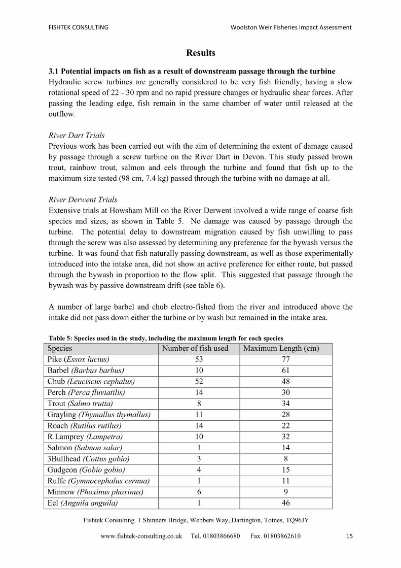
3.1 Potential impacts on fish as a result of downstream passage through the turbine
Hydraulic screw turbines are generally considered to be very fish friendly, having a slow
rotational speed of 22 - 30 rpm and no rapid pressure changes or hydraulic shear forces. After
passing the leading edge, fish remain in the same chamber of water until released at the
outflow.
River Dart Trials
Previous work has been carried out with the aim of determining the extent of damage caused
by passage through a screw turbine on the River Dart in Devon. This study passed brown
trout, rainbow trout, salmon and eels through the turbine and found that fish up to the
maximum size tested (98 cm, 7.4 kg) passed through the turbine with no damage at all.
River Derwent Trials
Extensive trials at Howsham Mill on the River Derwent involved a wide range of coarse fish
species and sizes, as shown in Table 5. No damage was caused by passage through the
turbine. The potential delay to downstream migration caused by fish unwilling to pass
through the screw was also assessed by determining any preference for the bywash versus the
turbine. It was found that fish naturally passing downstream, as well as those experimentally
introduced into the intake area, did not show an active preference for either route, but passed
through the bywash in proportion to the flow split. This suggested that passage through the
bywash was by passive downstream drift (see table 6).
A number of large barbel and chub electro-fished from the river and introduced above the
intake did not pass down either the turbine or by wash but remained in the intake area.
Table 5: Species used in the study, including the maximum length for each species
Species Number of fish used Maximum Length (cm)
Pike (Essox lucius) 53 77
Barbel (Barbus barbus) 10 61
Chub (Leuciscus cephalus) 52 48
Perch (Perca fluviatilis) 14 30
Trout (Salmo trutta) 8 34
Grayling (Thymallus thymallus) 11 28
Roach (Rutilus rutilus) 14 22
R.Lamprey (Lampetra) 10 32
Salmon (Salmon salar) 1 14
3Bullhead (Cottus gobio) 3 8
Gudgeon (Gobio gobio) 4 15
Ruffe (Gymnocephalus cernua) 1 11
Minnow (Phoxinus phoxinus) 6 9
Eel (Anguila anguila) 1 46
FISHTEK CONSULTING Woolston Weir Fisheries Impact Assessment
Fishtek Consulting. 1 Shinners Bridge, Webbers Way, Dartington, Totnes, TQ96JY
www.fishtek-consulting.co.uk Tel. 01803866680 Fax. 01803862610 16
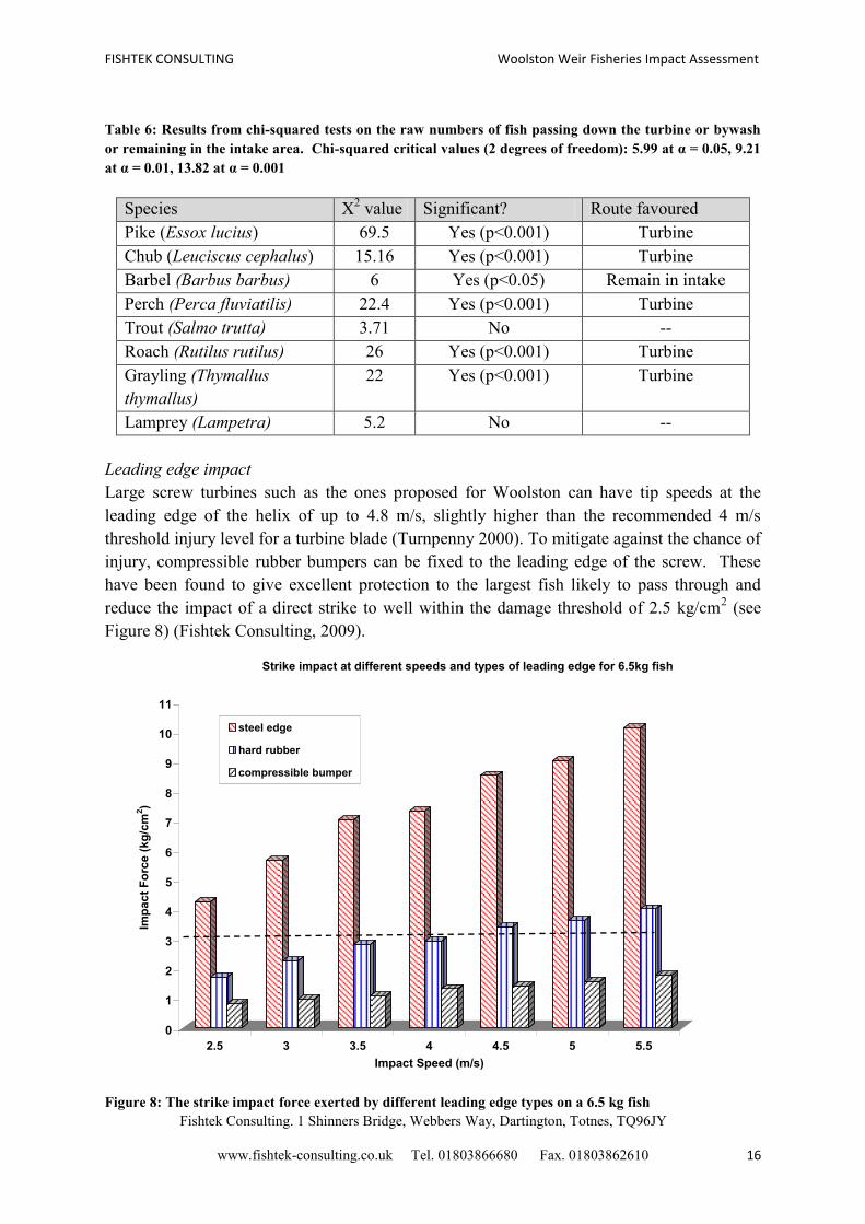
Table 6: Results from chi-squared tests on the raw numbers of fish passing down the turbine or bywash
or remaining in the intake area. Chi-squared critical values (2 degrees of freedom): 5.99 at α = 0.05, 9.21
at α = 0.01, 13.82 at α = 0.001
Species Χ2 value Significant? Route favoured
Pike (Essox lucius) 69.5 Yes (p<0.001) Turbine
Chub (Leuciscus cephalus) 15.16 Yes (p<0.001) Turbine
Barbel (Barbus barbus) 6 Yes (p<0.05) Remain in intake
Perch (Perca fluviatilis) 22.4 Yes (p<0.001) Turbine
Trout (Salmo trutta) 3.71 No --
Roach (Rutilus rutilus) 26 Yes (p<0.001) Turbine
Grayling (Thymallus
thymallus)
22 Yes (p<0.001) Turbine
Lamprey (Lampetra) 5.2 No --
Leading edge impact
Large screw turbines such as the ones proposed for Woolston can have tip speeds at the
leading edge of the helix of up to 4.8 m/s, slightly higher than the recommended 4 m/s
threshold injury level for a turbine blade (Turnpenny 2000). To mitigate against the chance of
injury, compressible rubber bumpers can be fixed to the leading edge of the screw. These
have been found to give excellent protection to the largest fish likely to pass through and
reduce the impact of a direct strike to well within the damage threshold of 2.5 kg/cm2 (see
Figure 8) (Fishtek Consulting, 2009).
Figure 8: The strike impact force exerted by different leading edge types on a 6.5 kg fish
0
1
2
3
4
5
6
7
8
9
10
11
Imp
ac
t F
orc
e (
kg
/cm
2)
2.5 3 3.5 4 4.5 5 5.5
Impact Speed (m/s)
Strike impact at different speeds and types of leading edge for 6.5kg fish
steel edge
hard rubber
compressible bumper
FISHTEK CONSULTING Woolston Weir Fisheries Impact Assessment
Fishtek Consulting. 1 Shinners Bridge, Webbers Way, Dartington, Totnes, TQ96JY
www.fishtek-consulting.co.uk Tel. 01803866680 Fax. 01803862610 17
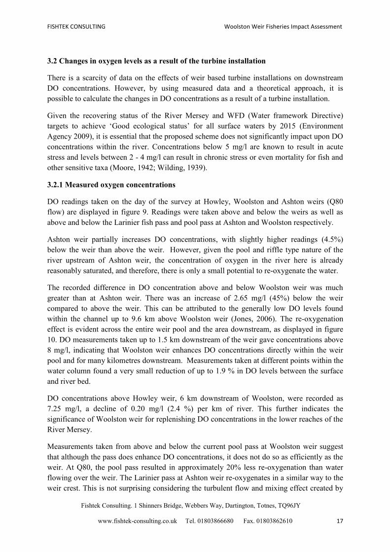
3.2 Changes in oxygen levels as a result of the turbine installation
There is a scarcity of data on the effects of weir based turbine installations on downstream
DO concentrations. However, by using measured data and a theoretical approach, it is
possible to calculate the changes in DO concentrations as a result of a turbine installation.
Given the recovering status of the River Mersey and WFD (Water framework Directive)
targets to achieve ‘Good ecological status’ for all surface waters by 2015 (Environment
Agency 2009), it is essential that the proposed scheme does not significantly impact upon DO
concentrations within the river. Concentrations below 5 mg/l are known to result in acute
stress and levels between 2 - 4 mg/l can result in chronic stress or even mortality for fish and
other sensitive taxa (Moore, 1942; Wilding, 1939).
3.2.1 Measured oxygen concentrations
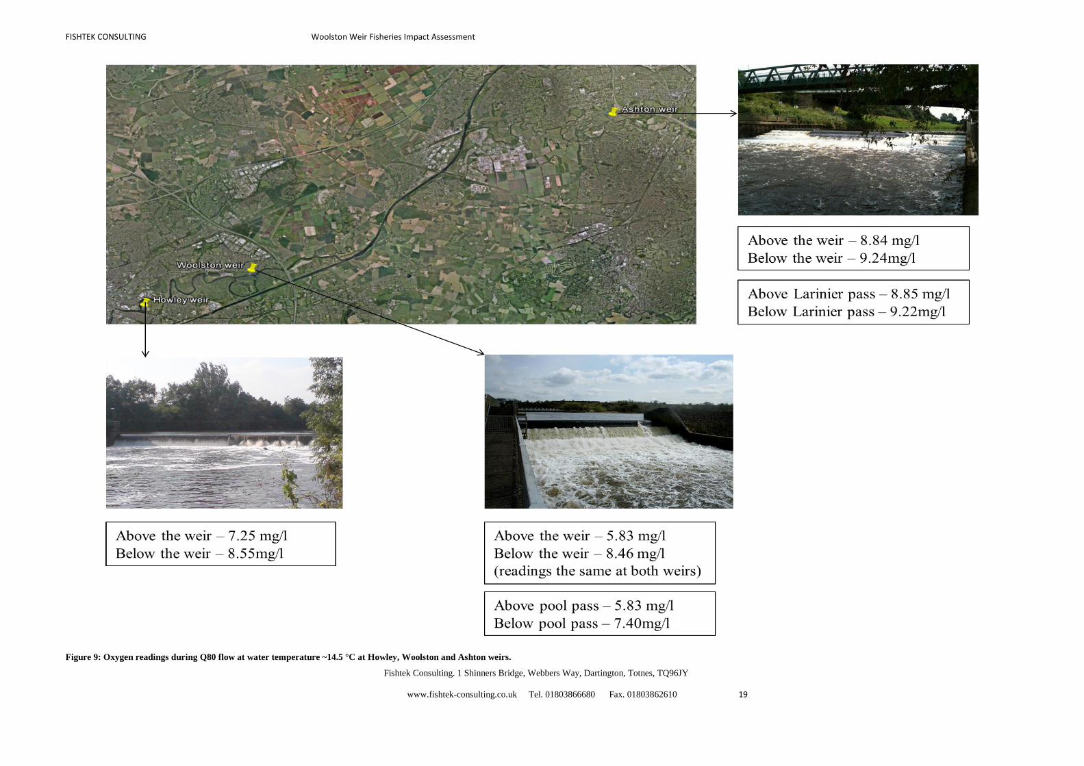
DO readings taken on the day of the survey at Howley, Woolston and Ashton weirs (Q80
flow) are displayed in figure 9. Readings were taken above and below the weirs as well as
above and below the Larinier fish pass and pool pass at Ashton and Woolston respectively.
Ashton weir partially increases DO concentrations, with slightly higher readings (4.5%)
below the weir than above the weir. However, given the pool and riffle type nature of the
river upstream of Ashton weir, the concentration of oxygen in the river here is already
reasonably saturated, and therefore, there is only a small potential to re-oxygenate the water.
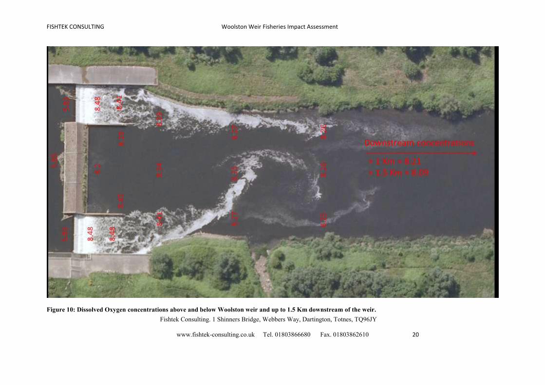
The recorded difference in DO concentration above and below Woolston weir was much
greater than at Ashton weir. There was an increase of 2.65 mg/l (45%) below the weir
compared to above the weir. This can be attributed to the generally low DO levels found
within the channel up to 9.6 km above Woolston weir (Jones, 2006). The re-oxygenation
effect is evident across the entire weir pool and the area downstream, as displayed in figure
10. DO measurements taken up to 1.5 km downstream of the weir gave concentrations above
8 mg/l, indicating that Woolston weir enhances DO concentrations directly within the weir
pool and for many kilometres downstream. Measurements taken at different points within the
water column found a very small reduction of up to 1.9 % in DO levels between the surface
and river bed.
DO concentrations above Howley weir, 6 km downstream of Woolston, were recorded as
7.25 mg/l, a decline of 0.20 mg/l (2.4 %) per km of river. This further indicates the
significance of Woolston weir for replenishing DO concentrations in the lower reaches of the
River Mersey.
Measurements taken from above and below the current pool pass at Woolston weir suggest
that although the pass does enhance DO concentrations, it does not do so as efficiently as the
weir. At Q80, the pool pass resulted in approximately 20% less re-oxygenation than water
flowing over the weir. The Larinier pass at Ashton weir re-oxygenates in a similar way to the
weir crest. This is not surprising considering the turbulent flow and mixing effect created by

FISHTEK CONSULTING Woolston Weir Fisheries Impact Assessment
Fishtek Consulting. 1 Shinners Bridge, Webbers Way, Dartington, Totnes, TQ96JY
www.fishtek-consulting.co.uk Tel. 01803866680 Fax. 01803862610 18
the Larinier baffles. It is expected that the Larinier pass at Woolston weir would re-oxygenate
water more effectively than the current pool and traverse pass.
FISHTEK CONSULTING Woolston Weir Fisheries Impact Assessment
Fishtek Consulting. 1 Shinners Bridge, Webbers Way, Dartington, Totnes, TQ96JY
www.fishtek-consulting.co.uk Tel. 01803866680 Fax. 01803862610 19
Figure 9: Oxygen readings during Q80 flow at water temperature ~14.5 °C at Howley, Woolston and Ashton weirs.
FISHTEK CONSULTING Woolston Weir Fisheries Impact Assessment
Fishtek Consulting. 1 Shinners Bridge, Webbers Way, Dartington, Totnes, TQ96JY
www.fishtek-consulting.co.uk Tel. 01803866680 Fax. 01803862610 20
Figure 10: Dissolved Oxygen concentrations above and below Woolston weir and up to 1.5 Km downstream of the weir.
FISHTEK CONSULTING Woolston Weir Fisheries Impact Assessment
Fishtek Consulting. 1 Shinners Bridge, Webbers Way, Dartington, Totnes, TQ96JY
www.fishtek-consulting.co.uk Tel. 01803866680 Fax. 01803862610 21
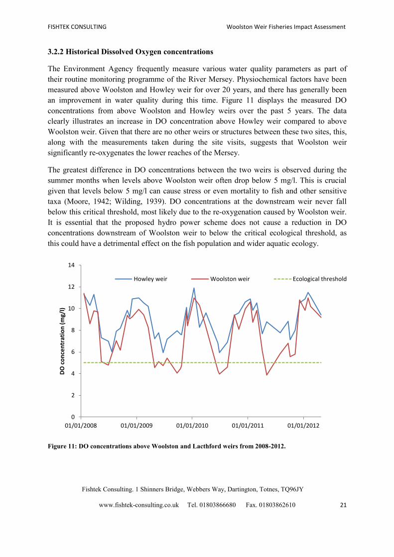
3.2.2 Historical Dissolved Oxygen concentrations
The Environment Agency frequently measure various water quality parameters as part of
their routine monitoring programme of the River Mersey. Physiochemical factors have been
measured above Woolston and Howley weir for over 20 years, and there has generally been
an improvement in water quality during this time. Figure 11 displays the measured DO
concentrations from above Woolston and Howley weirs over the past 5 years. The data
clearly illustrates an increase in DO concentration above Howley weir compared to above
Woolston weir. Given that there are no other weirs or structures between these two sites, this,
along with the measurements taken during the site visits, suggests that Woolston weir
significantly re-oxygenates the lower reaches of the Mersey.
The greatest difference in DO concentrations between the two weirs is observed during the
summer months when levels above Woolston weir often drop below 5 mg/l. This is crucial
given that levels below 5 mg/l can cause stress or even mortality to fish and other sensitive
taxa (Moore, 1942; Wilding, 1939). DO concentrations at the downstream weir never fall
below this critical threshold, most likely due to the re-oxygenation caused by Woolston weir.
It is essential that the proposed hydro power scheme does not cause a reduction in DO
concentrations downstream of Woolston weir to below the critical ecological threshold, as
this could have a detrimental effect on the fish population and wider aquatic ecology.
Figure 11: DO concentrations above Woolston and Lacthford weirs from 2008-2012.
0
2
4
6
8
10
12
14
01/01/2008 01/01/2009 01/01/2010 01/01/2011 01/01/2012
DO
co
nce
ntr
atio
n (
mg/
l)
Howley weir Woolston weir Ecological threshold

FISHTEK CONSULTING Woolston Weir Fisheries Impact Assessment
Fishtek Consulting. 1 Shinners Bridge, Webbers Way, Dartington, Totnes, TQ96JY
www.fishtek-consulting.co.uk Tel. 01803866680 Fax. 01803862610 22
3.2.3 Predicted Oxygen concentrations as a result of turbine installation
There is a lack of evidence as to the effects that hydro turbines have on dissolved oxygen
(DO) concentration, with available literature focusing on mitigation to enhance DO
concentration in waters leaving reservoirs or dams in which oxygen concentrations are low
due to stagnation (Bevelhimer & Coutant 2006). Work has, however, been conducted to
investigate the degree to which dams and weirs may re-oxygenate water flowing over them
(Markofsky 1978). In sluggish streams, more oxygen may be absorbed by water flowing over
a weir or dam than in a long reach between them.
It is possible to calculate the re-aeration of water passing over a dam or weir using the
following formulae (taken from Lee and Lin, 2000):
r = 1 + 0.11qb(1 + 0.046T)h
Where:
r = dissolved oxygen deficit ratio at temperature T
q = water quality correction factor
b = weir correction factor
T = water temperature (oC)
h = height through which the water falls (ft)
The deficit dissolved oxygen ratio is defined by:
r = (Cs – CA)/(Cs – CB) = DA/DB
Where:
CA dissolved oxygen concentration upstream of the weir (mg/l)
CB dissolved oxygen concentration downstream of the weir (mg/l)
Cs dissolved oxygen saturation concentration (mg/l)
DA dissolved oxygen deficit upstream of the weir (mg/l)
DB dissolved oxygen deficit downstream of the weir (mg/l)
Values of q are assigned using three generalised classifications of water. They are q = 1.25
for clean and slightly polluted water; q = 1.0 for moderately polluted water; and q = 0.8 for
grossly polluted water. A slightly polluted water is one in which there is no noticeable
deterioration of water quality as a result of sewage discharges. A moderately polluted stream
is one which receives significant quantities of sewage effluent and a grossly polluted stream
is one in which noxious conditions exist.
The value of b is obtained by taking the geometrical shape of the dam into consideration, as
this influences the extent of re-aeration of water passing over the weir. Values of b have been
calculated for various spillway types as follows:
FISHTEK CONSULTING Woolston Weir Fisheries Impact Assessment
Fishtek Consulting. 1 Shinners Bridge, Webbers Way, Dartington, Totnes, TQ96JY
www.fishtek-consulting.co.uk Tel. 01803866680 Fax. 01803862610 23
Spillway type B
Stepped 1.3
Free 1.0
Slope (ogee) 0.58
Sloping channel 0.17
In the case of the installation of a hydroturbine, the unknown is the degree to which b will be
changed as a result of water flowing downstream through the turbine rather than passing over
the weir. An estimation of this can be obtained using the formulae above.
For the current situation at Woolston weir b = 1.3, since the weir has a stepped profile, and
h = 7.19 ft. Although markedly improved, the River Mersey is still considered to be slightly
polluted, mainly attributed to industrial waste discharge (Jones, 2006), and therefore q = 1.0.
Dissolved oxygen levels are likely to be lowest during summer. Temperature readings taken
during the site visit provided a mean reading of 14.5 °C. Therefore, in order to calculate r
during the summer months T = 14.5.
Using the pre-determined values for b,q and T, we can obtain r from:
r = 1 + 0.11qb(1 + 0.046T)h
Therefore: r = 1 + 0.11*1.0*1.3(1 + 0.046*14.5)*7.19 = 2.71
The dissolved oxygen saturation concentration (Cs) at 14.5oC under typical atmospheric
pressure is around 10 mg/L. Based on the dissolved oxygen concentration measured upstream
of the weir (5.83 mg/l), water quality (q) and the measured temperature of the River Mersey,
we can calculate the dissolved oxygen concentration downstream of the weir as follows:
r = (Cs – CA)/(Cs – CB)
Therefore: CB = Cs – (Cs-CA)/r = 10 – (10-5.83)/2.71 = 8.46 mg/L
Therefore, using the parameters defined above, the formula predicts that water passing over
the weir with an oxygen concentration of 5.83 mg/L will be re-aerated such that the oxygen
concentration below the weir increases to 8.46 mg/L. The actual measured DO concentration
below the weir was 8.43 mg/l (see figure 10), and therefore, the theoretical approach was able
to predict the concentration to within 0.2% of the actual value.
If it is assumed (taking a precautionary approach) that the turbine will reduce the value of b
to that of a sloping channel, 0.17, it is possible to calculate the degree to which the
hydroturbine will alter the dissolved oxygen concentration downstream of the weir. Based on
the proposed HOF, the split in flow has been calculated between the turbine, weir and fish
pass, and the overall increase in oxygen concentration downstream has been calculated. The
DO concentration above Howley weir has also been calculated, based on the previously

FISHTEK CONSULTING Woolston Weir Fisheries Impact Assessment
Fishtek Consulting. 1 Shinners Bridge, Webbers Way, Dartington, Totnes, TQ96JY
www.fishtek-consulting.co.uk Tel. 01803866680 Fax. 01803862610 24
calculated decline in concentration over this 6 km stretch. This approach has been taken for
two different HOF – a low HOF of 3.74 m3/s (based on a low combined flow through the fish
pass of and a low residual flow over the weir) and a best practice HOF of 8.1 m3/s (Q95), and
is based on two different upstream DO concentrations; the concentration measured above the
weir on the day of the survey (5.83 mg/l) and the lowest concentration recorded by the
Environment Agency in recent years (3.85 mg/l on the 06/05/2011). Although the lower of
these two concentrations is a ‘worst case’ scenario, it is important to consider the effects of
the turbine during periods of particularly low upstream DO concentration, as this is when fish
and other sensitive taxa are most likely to be affected. The results from this analysis are given
in table 7.
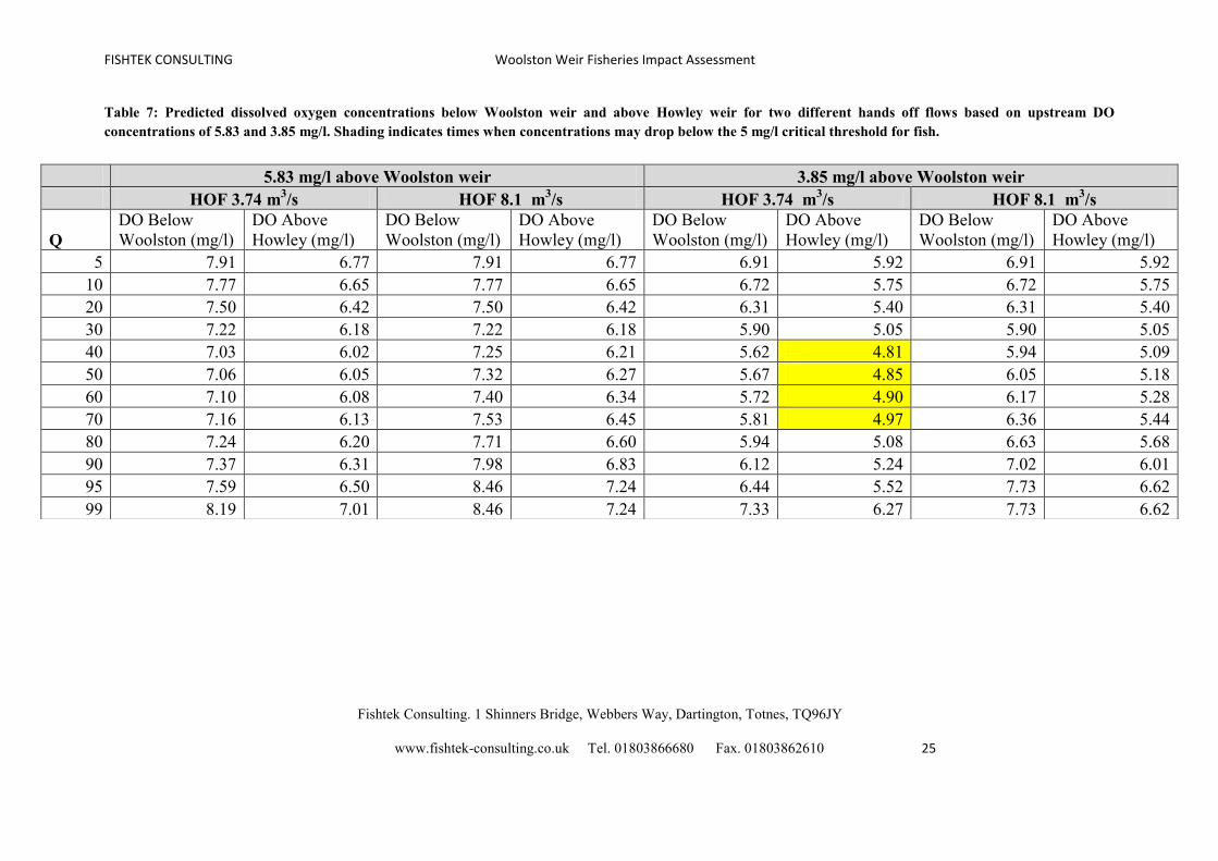
Assuming a DO concentration of 5.83 mg/l above Woolston weir, it is predicted that although
the proposed hydro scheme will result in a decline in DO concentrations immediately below
the weir and subsequently above Howley weir, concentrations will still remain above the
critical threshold at both HOFs; although it is slightly reduced for the lower HOF. However,
if we assume the lowest DO concentration recorded in recent years (3.85 mg/l), the
installation of the hydro turbines with the low HOF would likely result in DO concentrations
above Howley weir falling below the critical threshold. A Q95 HOF, however, would
maintain oxygen levels above the critical threshold within the weir pool and further
downstream.
FISHTEK CONSULTING Woolston Weir Fisheries Impact Assessment
Fishtek Consulting. 1 Shinners Bridge, Webbers Way, Dartington, Totnes, TQ96JY
www.fishtek-consulting.co.uk Tel. 01803866680 Fax. 01803862610 25
Table 7: Predicted dissolved oxygen concentrations below Woolston weir and above Howley weir for two different hands off flows based on upstream DO
concentrations of 5.83 and 3.85 mg/l. Shading indicates times when concentrations may drop below the 5 mg/l critical threshold for fish.
5.83 mg/l above Woolston weir 3.85 mg/l above Woolston weir
HOF 3.74 m3/s HOF 8.1 m
3/s HOF 3.74 m
3/s HOF 8.1 m
3/s
Q
DO Below
Woolston (mg/l)
DO Above
Howley (mg/l)
DO Below
Woolston (mg/l)
DO Above
Howley (mg/l)
DO Below
Woolston (mg/l)
DO Above
Howley (mg/l)
DO Below
Woolston (mg/l)
DO Above
Howley (mg/l)
5 7.91 6.77 7.91 6.77 6.91 5.92 6.91 5.92
10 7.77 6.65 7.77 6.65 6.72 5.75 6.72 5.75
20 7.50 6.42 7.50 6.42 6.31 5.40 6.31 5.40
30 7.22 6.18 7.22 6.18 5.90 5.05 5.90 5.05
40 7.03 6.02 7.25 6.21 5.62 4.81 5.94 5.09
50 7.06 6.05 7.32 6.27 5.67 4.85 6.05 5.18
60 7.10 6.08 7.40 6.34 5.72 4.90 6.17 5.28
70 7.16 6.13 7.53 6.45 5.81 4.97 6.36 5.44
80 7.24 6.20 7.71 6.60 5.94 5.08 6.63 5.68
90 7.37 6.31 7.98 6.83 6.12 5.24 7.02 6.01
95 7.59 6.50 8.46 7.24 6.44 5.52 7.73 6.62
99 8.19 7.01 8.46 7.24 7.33 6.27 7.73 6.62
FISHTEK CONSULTING Woolston Weir Fisheries Impact Assessment
Fishtek Consulting. 1 Shinners Bridge, Webbers Way, Dartington, Totnes, TQ96JY
www.fishtek-consulting.co.uk Tel. 01803866680 Fax. 01803862610 26
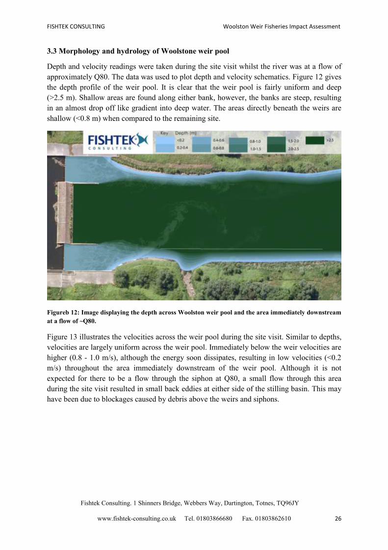
3.3 Morphology and hydrology of Woolstone weir pool
Depth and velocity readings were taken during the site visit whilst the river was at a flow of
approximately Q80. The data was used to plot depth and velocity schematics. Figure 12 gives
the depth profile of the weir pool. It is clear that the weir pool is fairly uniform and deep
(>2.5 m). Shallow areas are found along either bank, however, the banks are steep, resulting
in an almost drop off like gradient into deep water. The areas directly beneath the weirs are
shallow (<0.8 m) when compared to the remaining site.
Figureb 12: Image displaying the depth across Woolston weir pool and the area immediately downstream
at a flow of ~Q80.
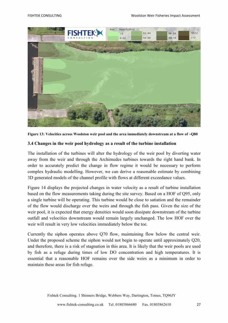
Figure 13 illustrates the velocities across the weir pool during the site visit. Similar to depths,
velocities are largely uniform across the weir pool. Immediately below the weir velocities are
higher (0.8 - 1.0 m/s), although the energy soon dissipates, resulting in low velocities (<0.2
m/s) throughout the area immediately downstream of the weir pool. Although it is not
expected for there to be a flow through the siphon at Q80, a small flow through this area
during the site visit resulted in small back eddies at either side of the stilling basin. This may
have been due to blockages caused by debris above the weirs and siphons.
FISHTEK CONSULTING Woolston Weir Fisheries Impact Assessment
Fishtek Consulting. 1 Shinners Bridge, Webbers Way, Dartington, Totnes, TQ96JY
www.fishtek-consulting.co.uk Tel. 01803866680 Fax. 01803862610 27
Figure 13: Velocities across Woolston weir pool and the area immediately downstream at a flow of ~Q80
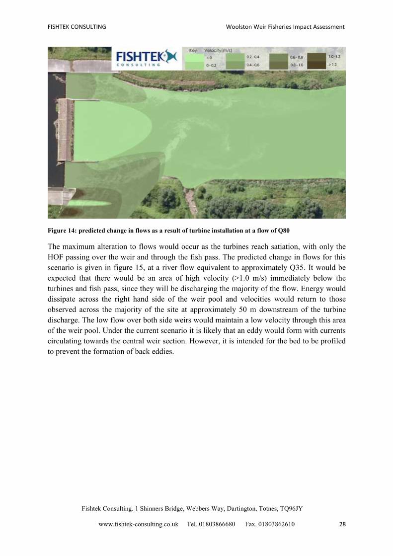
3.4 Changes in the weir pool hydrology as a result of the turbine installation
The installation of the turbines will alter the hydrology of the weir pool by diverting water
away from the weir and through the Archimedes turbines towards the right hand bank. In
order to accurately predict the change in flow regime it would be necessary to perform
complex hydraulic modelling. However, we can derive a reasonable estimate by combining
3D generated models of the channel profile with flows at different exceedance values.
Figure 14 displays the projected changes in water velocity as a result of turbine installation
based on the flow measurements taking during the site survey. Based on a HOF of Q95, only
a single turbine will be operating. This turbine would be close to satiation and the remainder
of the flow would discharge over the weirs and through the fish pass. Given the size of the
weir pool, it is expected that energy densities would soon dissipate downstream of the turbine
outfall and velocities downstream would remain largely unchanged. The low HOF over the
weir will result in very low velocities immediately below the toe.
Currently the siphon operates above Q70 flow, maintaining flow below the central weir.
Under the proposed scheme the siphon would not begin to operate until approximately Q20,
and therefore, there is a risk of stagnation in this area. It is likely that the weir pools are used
by fish as a refuge during times of low DO concentration and high temperatures. It is
essential that a reasonable HOF remains over the side weirs as a minimum in order to
maintain these areas for fish refuge.
FISHTEK CONSULTING Woolston Weir Fisheries Impact Assessment
Fishtek Consulting. 1 Shinners Bridge, Webbers Way, Dartington, Totnes, TQ96JY
www.fishtek-consulting.co.uk Tel. 01803866680 Fax. 01803862610 28
Figure 14: predicted change in flows as a result of turbine installation at a flow of Q80
The maximum alteration to flows would occur as the turbines reach satiation, with only the
HOF passing over the weir and through the fish pass. The predicted change in flows for this
scenario is given in figure 15, at a river flow equivalent to approximately Q35. It would be
expected that there would be an area of high velocity (>1.0 m/s) immediately below the
turbines and fish pass, since they will be discharging the majority of the flow. Energy would
dissipate across the right hand side of the weir pool and velocities would return to those
observed across the majority of the site at approximately 50 m downstream of the turbine
discharge. The low flow over both side weirs would maintain a low velocity through this area
of the weir pool. Under the current scenario it is likely that an eddy would form with currents
circulating towards the central weir section. However, it is intended for the bed to be profiled
to prevent the formation of back eddies.
FISHTEK CONSULTING Woolston Weir Fisheries Impact Assessment
Fishtek Consulting. 1 Shinners Bridge, Webbers Way, Dartington, Totnes, TQ96JY
www.fishtek-consulting.co.uk Tel. 01803866680 Fax. 01803862610 29
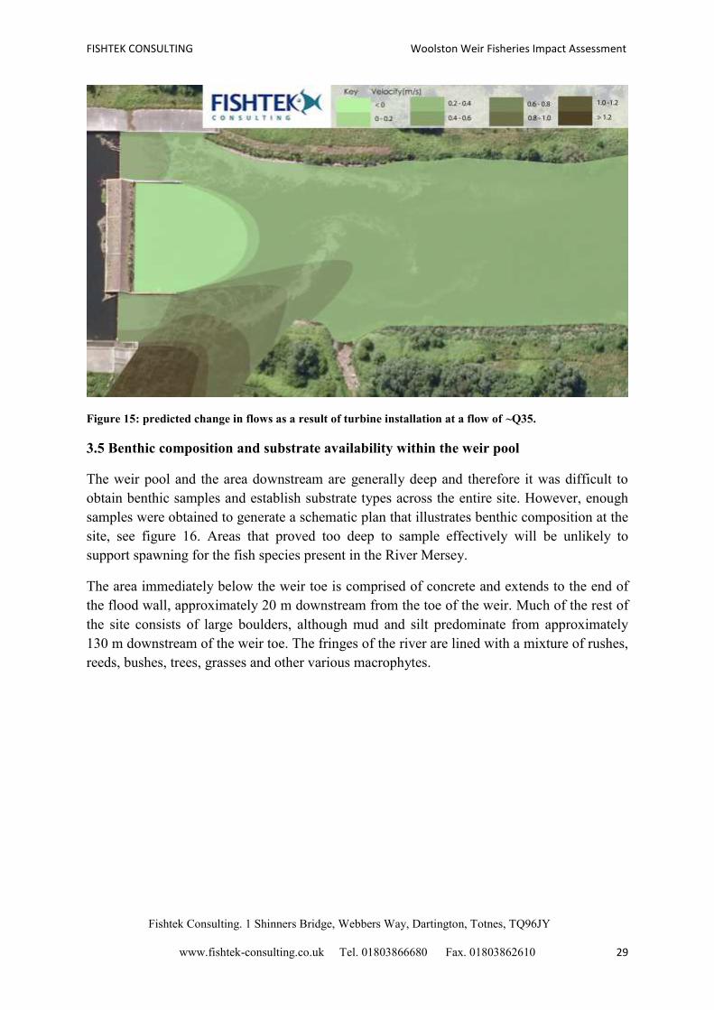
Figure 15: predicted change in flows as a result of turbine installation at a flow of ~Q35.
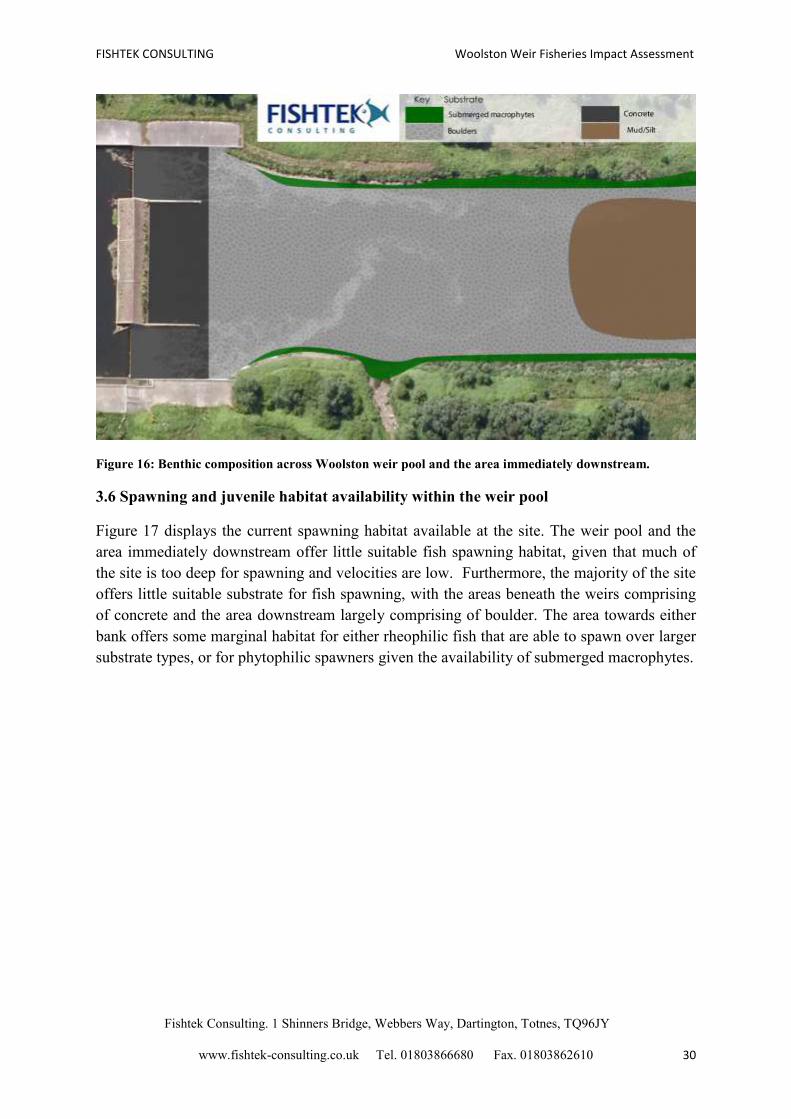
3.5 Benthic composition and substrate availability within the weir pool
The weir pool and the area downstream are generally deep and therefore it was difficult to
obtain benthic samples and establish substrate types across the entire site. However, enough
samples were obtained to generate a schematic plan that illustrates benthic composition at the
site, see figure 16. Areas that proved too deep to sample effectively will be unlikely to
support spawning for the fish species present in the River Mersey.
The area immediately below the weir toe is comprised of concrete and extends to the end of
the flood wall, approximately 20 m downstream from the toe of the weir. Much of the rest of
the site consists of large boulders, although mud and silt predominate from approximately
130 m downstream of the weir toe. The fringes of the river are lined with a mixture of rushes,
reeds, bushes, trees, grasses and other various macrophytes.
FISHTEK CONSULTING Woolston Weir Fisheries Impact Assessment
Fishtek Consulting. 1 Shinners Bridge, Webbers Way, Dartington, Totnes, TQ96JY
www.fishtek-consulting.co.uk Tel. 01803866680 Fax. 01803862610 30
Figure 16: Benthic composition across Woolston weir pool and the area immediately downstream.
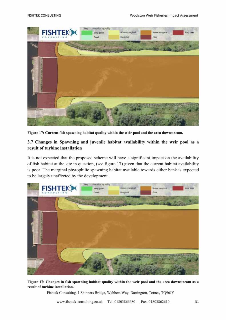
3.6 Spawning and juvenile habitat availability within the weir pool
Figure 17 displays the current spawning habitat available at the site. The weir pool and the
area immediately downstream offer little suitable fish spawning habitat, given that much of
the site is too deep for spawning and velocities are low. Furthermore, the majority of the site
offers little suitable substrate for fish spawning, with the areas beneath the weirs comprising
of concrete and the area downstream largely comprising of boulder. The area towards either
bank offers some marginal habitat for either rheophilic fish that are able to spawn over larger
substrate types, or for phytophilic spawners given the availability of submerged macrophytes.
FISHTEK CONSULTING Woolston Weir Fisheries Impact Assessment
Fishtek Consulting. 1 Shinners Bridge, Webbers Way, Dartington, Totnes, TQ96JY
www.fishtek-consulting.co.uk Tel. 01803866680 Fax. 01803862610 31
Figure 17: Current fish spawning habitat quality within the weir pool and the area downstream.
3.7 Changes in Spawning and juvenile habitat availability within the weir pool as a
result of turbine installation
It is not expected that the proposed scheme will have a significant impact on the availability
of fish habitat at the site in question, (see figure 17) given that the current habitat availability
is poor. The marginal phytophilic spawning habitat available towards either bank is expected
to be largely unaffected by the development.
Figure 17: Changes in fish spawning habitat quality within the weir pool and the area downstream as a
result of turbine installation.
FISHTEK CONSULTING Woolston Weir Fisheries Impact Assessment
Fishtek Consulting. 1 Shinners Bridge, Webbers Way, Dartington, Totnes, TQ96JY
www.fishtek-consulting.co.uk Tel. 01803866680 Fax. 01803862610 32
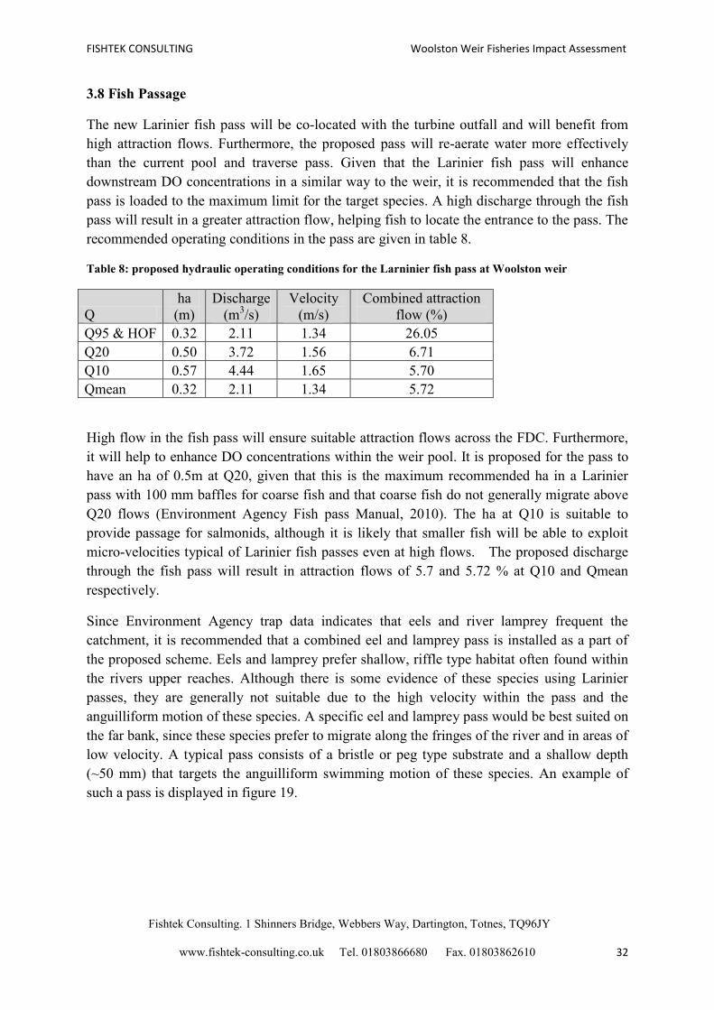
3.8 Fish Passage
The new Larinier fish pass will be co-located with the turbine outfall and will benefit from
high attraction flows. Furthermore, the proposed pass will re-aerate water more effectively
than the current pool and traverse pass. Given that the Larinier fish pass will enhance
downstream DO concentrations in a similar way to the weir, it is recommended that the fish
pass is loaded to the maximum limit for the target species. A high discharge through the fish
pass will result in a greater attraction flow, helping fish to locate the entrance to the pass. The
recommended operating conditions in the pass are given in table 8.
Table 8: proposed hydraulic operating conditions for the Larninier fish pass at Woolston weir
Q
ha
(m)
Discharge
(m3/s)
Velocity
(m/s)
Combined attraction
flow (%)
Q95 & HOF 0.32 2.11 1.34 26.05
Q20 0.50 3.72 1.56 6.71
Q10 0.57 4.44 1.65 5.70
Qmean 0.32 2.11 1.34 5.72
High flow in the fish pass will ensure suitable attraction flows across the FDC. Furthermore,
it will help to enhance DO concentrations within the weir pool. It is proposed for the pass to
have an ha of 0.5m at Q20, given that this is the maximum recommended ha in a Larinier
pass with 100 mm baffles for coarse fish and that coarse fish do not generally migrate above
Q20 flows (Environment Agency Fish pass Manual, 2010). The ha at Q10 is suitable to
provide passage for salmonids, although it is likely that smaller fish will be able to exploit
micro-velocities typical of Larinier fish passes even at high flows. The proposed discharge
through the fish pass will result in attraction flows of 5.7 and 5.72 % at Q10 and Qmean
respectively.
Since Environment Agency trap data indicates that eels and river lamprey frequent the
catchment, it is recommended that a combined eel and lamprey pass is installed as a part of
the proposed scheme. Eels and lamprey prefer shallow, riffle type habitat often found within
the rivers upper reaches. Although there is some evidence of these species using Larinier
passes, they are generally not suitable due to the high velocity within the pass and the
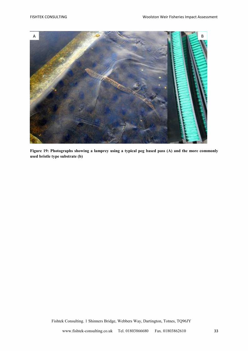
anguilliform motion of these species. A specific eel and lamprey pass would be best suited on
the far bank, since these species prefer to migrate along the fringes of the river and in areas of
low velocity. A typical pass consists of a bristle or peg type substrate and a shallow depth
(~50 mm) that targets the anguilliform swimming motion of these species. An example of
such a pass is displayed in figure 19.
FISHTEK CONSULTING Woolston Weir Fisheries Impact Assessment
Fishtek Consulting. 1 Shinners Bridge, Webbers Way, Dartington, Totnes, TQ96JY
www.fishtek-consulting.co.uk Tel. 01803866680 Fax. 01803862610 33
Figure 19: Photographs showing a lamprey using a typical peg based pass (A) and the more commonly
used bristle type substrate (b)
B A
FISHTEK CONSULTING Woolston Weir Fisheries Impact Assessment
Fishtek Consulting. 1 Shinners Bridge, Webbers Way, Dartington, Totnes, TQ96JY
www.fishtek-consulting.co.uk Tel. 01803866680 Fax. 01803862610 34
4. Conclusions and Recommendations
The hydropower turbines will result in a change to the hydrological profile of the weir pool
and a slight shift in habitat availability for a distance of up to 50 m downstream of the turbine
outfall. Immediately below the turbine and Larinier passes, it is predicted that velocities will
increase and a back eddy may form in the centre of the weir toe area. It is recommended that
at least 1 m3/s is discharged over each weir at all times in order to maintain some mixing
within the weir pools and to prevent stagnation of the water. Velocities immediately
downstream of the weir pool are expected to remain largely unchanged, given that energy
densities caused by the turbine and fish pass should dissipate fairly rapidly within the large
area downstream. The siphon would rarely function under the proposed operating conditions,
and therefore, it would be necessary to maintain a reasonable flow over the side weirs in
order to maintain areas of fish refuge. It is likely that the area immediately below the fish
pass would offer some additional fish refuge habitat at times of low flow and low DO
concentrations.
It is not expected that the change in the hydrological profile of the weir would reduce the
availability of fish habitat within the weir pool, given that much of the weir pool is deemed
unsuitable for spawning. The area immediately below the weirs is comprised of concrete and
much of the remaining weir pool is deep with a boulder substrate, offering very little
spawning opportunity. Towards the banks of the river there are some submerged macrophytes
that could offer some spawning potential to phytophilic fish.
DO concentrations above Woolston weir are lower than those recorded within the weir pool
and also in the 6 km stretch down to Howley weir, suggesting that re-oxygenation at the weir
elevates DO levels for a considerable reach downstream. Currently, DO concentrations above
Howley weir have not fallen below the critical threshold in recent years. Under a low HOF
scenario, there is a risk that downstream DO concentrations may drop below the critical
threshold for fish and other sensitive taxa (5 mg/l). Therefore, it is recommended that the
scheme either; a) reverts to a higher HOF equivalent to a river discharge of Q95, which
would maintain acceptable DO concentrations within the weir pool and the 6 km reach
downstream, or b) implements mitigation and monitoring to ensure oxygen concentrations are
maintained above the 5 mg/l threshold. In order for levels above Howley weir to remain
above this level, it is essential that DO concentrations within Woolston weir pool do not drop
below 6 mg/l.
Suitable mitigation that could prevent a sag in DO concentrations would be achieved with the
use of aeration devices that are able to artificially increase DO levels when necessary. These
devices can be linked to sensors that initiate aeration when concentrations fall below the
recommended 6 mg/l. Furthermore, in extreme circumstance, for example if DO
concentrations within the weir pool were to drop below 5 mg/l, an ‘off protocol’ could shut
down the turbines to allow more flow over the weir, allowing DO levels to quickly recover to
an acceptable level. Installing continuous data loggers above and below Woolston weir and
also above Howley weir would allow the effects of the turbines to be monitored and
quantified. This will also allow for the specific impact of the hydro scheme to be monitored
FISHTEK CONSULTING Woolston Weir Fisheries Impact Assessment
Fishtek Consulting. 1 Shinners Bridge, Webbers Way, Dartington, Totnes, TQ96JY
www.fishtek-consulting.co.uk Tel. 01803866680 Fax. 01803862610 35
and mitigated for. Logging devices can be battery operated and the data can be stored on
various forms of removable storage for many months at a time. It may be possible for any
current Environment Agency DO monitoring to form a part of the proposed turbine
monitoring.
The proposed Larinier fish pass will greatly improve the opportunities for fish migration. The
multi-species pass will allow passage of both coarse fish and migratory salmonids across the
FDC. Furthermore, the proposed location of the fish pass entrance will allow an
augmentation of flows that will attract fish to this area. It is recommended that the pass
generates as high attraction flow as possible, achieved by loading the passes to within the
maximum capacity limits of the target species. A discharge of 2.11 m3/s is recommended in
the pass across the HOF, giving a ha of 0.32 m.
In addition to the fish pass, it is recommended that a combined eel and lamprey pass is
installed as part of the scheme. Eels and Lampreys are more likely to migrate along the banks
of the river and prefer areas of low velocity; it is therefore recommended that the pass is
installed on the left hand side of the weir, away from the turbulent turbine outfall.
A low HOF (below Q95) is likely to cause sags in DO concentration if it is adopted without
any of the recommended mitigation. However, with the correct mitigation, a lower HOF is
possible, although flows of below 4.11 m3/s are associated with a greater risk. A suitable
HOF should consider the suggested flows through the fish pass and 1 m3/s over each of the
stepped weirs.
FISHTEK CONSULTING Woolston Weir Fisheries Impact Assessment
Fishtek Consulting. 1 Shinners Bridge, Webbers Way, Dartington, Totnes, TQ96JY
www.fishtek-consulting.co.uk Tel. 01803866680 Fax. 01803862610 36
5. References
Arlinghaus, R. and Wolter, C. (2003). Amplitude of ecological potential: chub Leuciscus
cephalus (L.) spawning in an artificial lowland canal. Journal of Applied Ichthyology, 19: 52-
54.
Armstrong, J.D.,Kemp, P.S., Kennedy, G.J.A., Ladle M., milner, M.J. (2003). Habitat
requirements of Atlantic salmon and brown trout in rivers and streams. Fisheries Research,
62: 143-170.
Baras, E. and Nindaba, J. (1999). Seasonal and diel utilisation of inshore microhabitats by
larvae and juveniles of Leuciscus cephalus and Leuciscus leuciscus. Environmental Biology
of Fishes, 56: 183-197.
Beland, K.F., Jordan, R.M., Meister, A.L. (1982). Water Depth and Velocity Preferences of
Spawning Atlantic Salmon in Maine Rivers. North American journal of Fisheries
Management 2 (1): 11-13.
Bevelhimer, M.S., Coutant, C.C. (2006) Assessment of disloved oxygen mitigation at
hydropower Dams Using an integrated Hydroynamic/Water quality/ Fish growth model.
Report, Environmental Sciences Division.
Bless, R. (1992). Insights into the ecology of Phoxinus phoxinus. Nature, 35: 57
Copp, G.H. (1990). Shifts in the microhabitat of larval and juvenile roach Rutilus rutilus (L.)
in a floddplain channel. J. Fish. Biol. 36: 683-692.
Copp, G.H. (1992). An empirical model for predicting microhabitat of 0+ juvenile fishes in
a lowland river catchment. Oecologia, 91: 338-345
Copp, G.H. (1997). Microhabitat use of fish larvae and 0+ juveniles in a highly regulated
section of the river Great Ouse. Regulated Rivers: Research and Management, 13: 267-276
Cowx, I., Welcomme, R. (1998). Rehabilitation of river for fish. Fishing new books, Oxford
and Northampton.
Crisp, D.T. (1996). Environmental requirements of common riverine European salmonid fish
species in fresh water with particular reference to physical and chemical aspects.
Hydrobiologia 323 (3): 201-221.
Environment Agency (2009). Environment Agency river basin management plan, North West
river basin district. Environment Agency, Rio House.
Environment Agency (2009). The Mersey life project. Vision statement and outline plan.
Environment Agency, March 2008, Rio House.
Environment Agency (2008). Water for life and livelihoods. River basin management plan .
north west river basin district. Environment Agency, Rio House.
FISHTEK CONSULTING Woolston Weir Fisheries Impact Assessment
Fishtek Consulting. 1 Shinners Bridge, Webbers Way, Dartington, Totnes, TQ96JY
www.fishtek-consulting.co.uk Tel. 01803866680 Fax. 01803862610 37
Environment Agency. Salmon behaviour in the Mersey catchment. Environment Agency,
Richard Fairclough House.
Fishtek Consulting (2007). Fish monitoring and live fish trials. Ritz Atro Archimedes Screw
Turbine, River Dart. Phase 1 Report: Live fish trials, smolts, leading edge assessment,
disorientation study, outflow monitoring.
Fishtek Consulting (2008). Archimedes Screw Turbine Fisheries Assessment. Phase II: Eels
and kelts.
Hendry K & Cragg-Hine D (1997). Restoration of riverine salmon habitats. Fisheries
Technical Manual 4 Environment Agency, Bristol.
Jones, P.D. (2006). Breathing new life into the Mersey. Water quality and fisheries in the
Mersey: An historical perspective. Published online, Environment Agency Warringotn.
Kondolf, G.M., Wolman, M.G. (1993). The saize of salmonids spawning gravel. water
Resources Research 29: 2275-2285.
Kondolf, G.M. (2000). Assessing salmonid spawning gravel quality. Transactions of the
American Fisheries Soceity. 129: 262-281.
Lariner, M. and Miralles, A. (1981). Etude hydraulique des passes a ralentisseurs (Hydraulic
study of Denil fishways). Unpublished report, CEMAGREF. pp53
Lee, C.C. and Lin, S.D. (2000). Handbook of environmental engineering calculations.
McGraw-Hill.
Lelek, A.M. (1987). Notes on the reproductive ecology of the feral form of the common carp,
Cyprinus carpio carpio, in the Rhine river. Proc. 5th
congr. European Icthyol. Stockholm
1985: 169-173.
Lightfoot, G. W., Jones, N. V. (1979). The relationship between the size of 0+ group roach
(Rutilus rutilus(L.) ) their swimming capabilities and distribution in a river. Proceedings of
the First British Freshwater Conference, University of Liverpool. pp. 230-236.
Lindeberg (2011). Atlantic salmon (Salmo salar) migration behaviour and preferences in
smolts, spawners and kelts. Online publication, http://stud.epsilon.slu.se.
Louhi, P., A. Mäki-Petäys. (2008). Spawning habitat of Atlantic salmon and brown trout:
general criteria and intragravel factors. River Research and Applications 24(3): 330-339.
Mann, R.H.K. (1996). Environmental requirements of European non-salmonid fish in rivers.
Hydrobiologia, 323: 223-235.
Markofsky, M., Kobus, H. (1978). Unified presentation of weir aeration data. Journal of
hydrological Engineering. ASCE. 104(4): 562–568.
Mills, C.A. (1981). The Spawning of Roach Rutilus rutilus (L.) in a Chalk Stream.
Aquaculture Research, 12: 49-54.
FISHTEK CONSULTING Woolston Weir Fisheries Impact Assessment
Fishtek Consulting. 1 Shinners Bridge, Webbers Way, Dartington, Totnes, TQ96JY
www.fishtek-consulting.co.uk Tel. 01803866680 Fax. 01803862610 38
Moore, W.G. (1942). Field Studies on the Oxygen Requirements of Certain Fresh-Water
Fishes. Ecology, 23: 319-329.
Nunn, A.D., Harvey, J.P., Cowx, I.G. (2007). Benefits to 0+ fishes of connecting man-made
water boddies to the lower River Trent, Engand. River Research and Applications, 23; 361-
376.
Phillips, R., Rix, M. (1985). A guide to the freshwater fish of Britain Ireland and Europe. Pan
Books Ltd. London. 1985.
Robson, B. (2012). City Deals member briefing 2012. Northern Housing consortium July
2012.
Shirvell, C.S., Dungey, R.G. (1983). Microhabitats chosen by brown trout for feeding and
spawning in rivers. Trans. Am. Fish. Soc. 112: 355–367.
Wilding, J.L. (1939) Oxygen Threshold for Three Species of Fish. Ecology, 20: 253-263
Witzel, L., MacCrimmon, H. (1983). Redd-site selection by brook trout and brown trout in
southwestern Ontario streams. Trans. Am. Fish. Soc. 112: 760–771.
Wood, P. J. and P. D. Armitage (1997). Biological Effects of Fine Sediment in the Lotic
Environment. Environmental Management 21: 203-217.
Environment Peel Energy Limited August 2012 Version 5
Woolston Weir Hydropower Scheme Extended Phase 1 Habitat & Protected Species Surveys

Prepared by:
Chris Sutton, Ecologist
Checked by:
Lisa Rigby, Senior Ecologist
Approved by:
Owen Tucker, Principal Environmental Scientist
Woolston Weir Hydropower Scheme Extended Phase 1 Habitat and Protected Species Surveys
Rev No Comments Checked
by Approved
by Date
5 Final LR OT 10/08/2012
4 Update to include subsequent protected species survey LR OT 26/06/2012
3 Update to include DNO Route OT & NL OT 25/04/2012
2 Final OT & NP NP 19/04/2012
1 Final Draft OT & NP NP 16/04/2012
Aecom House, 179 Moss Lane , Altrincham, Cheshire, WA15 8FH Telephone: 0161 927 8200 Website: http://www.aecom.com Job No 60240598 Reference Woolston Weir Date Created June 2012 This document has been prepared by AECOM Limited for the sole use of our client (the “Client”) and in accordance with generally accepted consultancy principles, the budget for fees and the terms of reference agreed between AECOM Limited and the Client. Any information provided by third parties and referred to herein has not been checked or verified by AECOM Limited, unless otherwise expressly stated in the document. No third party may rely upon this document without the prior and express written agreement of AECOM Limited.

AECOM Woolston Weir Hydropower Scheme Extended Phase 1 Habitat & Protected Species Surveys
Environment
1 Introduction ....................................................................................................................................................................... 1
2 Methodology ...................................................................................................................................................................... 3
3 Results ............................................................................................................................................................................... 9
4 Further Surveys and Recommendations ...................................................................................................................... 16
References .................................................................................................................................................................................... 20
Figure 1 Grid Connection Route Options ................................................................................................................................... 21
Figure 2 Nature Conservation Designations Map ...................................................................................................................... 22
Figure 3 Extended Phase 1 Habitat Map ..................................................................................................................................... 23
Appendix A Scheme Information ................................................................................................................................................ 24
Appendix B Species Specific Legislation and Policies ............................................................................................................. 25
Appendix C Cheshire Region Biodiversity Action Plan ............................................................................................................ 29
Appendix D Target Notes ............................................................................................................................................................. 30
Appendix E Woolston Eyes SSSI Citation .................................................................................................................................. 31
Appendix F Site Photographs...................................................................................................................................................... 32
Appendix G Woolston Weir Breeding Bird Survey Interim Technical Note. ............................................................................ 35
Table of Contents
AECOM Woolston Weir Hydropower Scheme Extended Phase 1 Habitat & Protected Species Surveys 1
Environment
1.1 Introduction
AECOM has been appointed by Peel Energy Ltd to undertake an ecological assessment of land adjacent to Woolston Weir,
Warrington (approximate OS grid reference SJ 652 886), which may be affected by a proposed c.500kW rated hydropower
development (hereafter referred to as the ‘site’).The assessment also included two associated proposed grid connection routes.
The area of study included the land on the northern (right bank) and southern bank (left bank) immediately adjacent to the
existing weir and the land extending eastwards of the weir along the northern bank.
The ecological assessment included a desk study and ecological surveys including Extended Phase 1 Habitat, invasive species,
otter, water vole and great crested newt surveys.
An assessment of the impact of the proposed hydropower development on fish and fish habitats is provided in a separate report
and will not be considered any further by this assessment.
1.1.1 Document Control
An initial Phase 1 Habitat Survey report was issued in December 2012 as Version 2, and a subsequent version (Version 3),
including the two options for the Distribution Network Operator (DNO) grid connections. This version (Version 4) includes the
results of subsequent invasive and protected species surveys undertaken by AECOM between May and June 2012.
1.1.2 Proposed Scheme
This assessment is based on initial design concepts set out within Woolston Weir Options Appraisal (Renewables First, March
2012). The proposed hydropower development would consist of a new intake on the northern bank immediately upstream of the
current weir that would direct flows through an intake screen and three Archimedean screw turbines. The intake channel will
require the construction of a new retaining wall forming the new northern bank of the River Mersey at this point. A larinier fish
pass would also be installed adjacent to the existing weir. Further general arrangement and scheme information can be found in
the following drawing presented in Appendix A:
- Renewables First (May 2012) Retaining Wall General Arrangement and Isometrics (drawing number WOOLN_004).
At present there are two proposed grid connection route options and these have been illustrated in Figure 1. Both options run
adjacent to the river from the existing weir, heading east, until reaching Weir Lane. From this point Option 1 continues to run
north, along Weir Lane, whilst option 2 continues to follow the River Mersey. Option 2 then breaks away from the river and heads
north, through an area of amenity grassland. This area of amenity grassland falls between residential properties and private
gardens. Both options arrive at Edward Garden’s substation.
The Environment Agency intend to submit a planning application to develop flood defence walls and embankments either side
and behind the proposed development site. The flood defence plans do not form part of this development proposal but there may
be mutual benefits that are being explored.
1.2 Objectives
The main objective is to assess the ecological baseline conditions and to identify any ecological constraints to future
developments and potential impacts in relation to ecological receptors, including the potential impacts of development upon
protected habitats and species nearby.
This report is based on the findings of:
- An Ecological Desk Study;
- Extended Phase 1 Habitat Survey;
- Habitat Suitability Index Assessment; and
- Protected / Invasive Species Surveys (including badgers, GCN, water vole, otter, breeding birds, and invasive plant species).
The objectives of the surveys were:
- To undertake an on-line data search to obtain ecological data for the site and surrounding area (known as the Study Area);
- To review available existing ecological data for the site and surrounding area;
- To highlight any areas of nature conservation interest within or surrounding the site;
1 Introduction

AECOM Woolston Weir Hydropower Scheme Extended Phase 1 Habitat & Protected Species Surveys 2
Environment
- To identify Phase 1 Habitat types present, as defined in ‘Handbook for Phase 1 Habitat Survey’ Joint Nature Conservation
Committee (JNCC, 2010 reprint);
- To produce a description of each of the habitats present and provide a list of plant species found within them;
- To undertake preliminary investigations into the potential presence of any faunal species such as badger (Meles meles), bat,
breeding birds and amphibians (particularly great crested newt Triturus cristatus);
- To identify any ecological constraints to the proposed development;
- To suggest further ecological surveys that may be required prior to the development commencing; and
- To undertake a number of species specific surveys.
1.3 Legislation and Policy
In relation to significant habitats and protected species, key international and national legislation and policy includes:
- EC Directive 92/94/EEC on the conservation of natural habitats and of wild fauna and flora (1992);
- EC Directive 79/409/EEC on the conservation of wild birds (1979);
- The Bern Convention 1979;
- Natural Environment and Rural Communities Act 2006;
- Countryside and Rights of Way Act 2000. Section 74 of the Act provides the habitat types and species of principal importance
in England;
- The Protection of Badgers Act 1992;
- The Wildlife and Countryside Act 1981 (as amended);
- The Conservation of Habitats and Species Regulations 2010; and
- National Planning Policy Framework (NPFF).
The detailed legislation as applied to several specific protected species is provided in Appendix B.
1.3.1 Biodiversity Action Plans
The UK BAP was launched in 1994 (updated 2010) with the main aim ‘To conserve and enhance biological diversity within the
UK, and to contribute to the conservation of global biodiversity through all appropriate mechanisms’. The UK BAP comprises a
series of Action Plans for ‘priority’ habitats and species, determined by their status as globally threatened or rapidly declining in
the UK. The action plans outline measures required to conserve these priority habitats and species.
The UK BAP (UK Biodiversity Steering Group, 1995) lists a number of species as requiring conservation action, and
consequently Species Action Plans (SAPs) have been developed for the conservation of these species. The UK BAP also lists a
number of priority habitats that are of importance, for which Habitat Action Plans (HAPs) have been produced.
The national strategy for biodiversity is delivered at local level via Local Biodiversity Action Plans (LBAPs). The study area is
covered by the Cheshire Region Biodiversity Action Plan. The Cheshire region currently has 21 habitat action plans and 52
species action plans, which are listed in Appendix C.
1.3.2 Quality Assurance
This project has been undertaken in line with AECOM’s Integrated Management System (IMS). Our IMS places great emphasis
on professionalism, technical excellence, quality, environmental and Health and Safety management. All staff members are
committed to establishing and maintaining our accreditation to the international standards BS EN ISO 9001:2008 and
14001:2004 and BS OHSAS 18001:2007. In addition our IMS requires careful selection and monitoring of the performance of all
sub consultants and contractors.
All AECOM Ecologists are members of (at the appropriate level) the Institute of Ecology and Environmental Management (IEEM)
and follow their code of professional conduct when undertaking ecological work.
AECOM Woolston Weir Hydropower Scheme Extended Phase 1 Habitat & Protected Species Surveys 3
Environment
2.1 Desk Study
The objectives of the desk study are to review the existing available information to identify the following:
- Internationally, nationally and locally designated sites up to 2 km from the site;
- Special Areas of Conservation (SACs) designated for bats within a 5 km radius of the site;
- Records of protected species within the area; and
- Any other natural features of importance or concern.
The National Biodiversity Network (www.searchnbn.net) was also reviewed for recent records of notable and protected species in
the local area. Information relating to protected habitats was collated using the MAgiC website (http://magic.defra.gov.uk/). All
internationally and nationally designated sites within a 2 km radius of the site were identified. In accordance with Bat
Conservation Trust recommendations, Special Areas of Conservation (SACs) designated because of a known bat population,
were included in a search of up to a 5 km radius of the site.
A request for the provision of ecological information for the site and up to a 2 km radius from the site boundary was requested
from rECOrd, the local biological record centre, which included information on:
- Non statutory designated sites and associated citations;
- Legally protected species records; and
- Notable species or habitat records considered worthy of note from within the search area.
In addition, a review of the Woolston Eyes nature reserve website was undertaken, which is managed by the Woolston Eyes
Conservation Group.
Any information provided by these groups will need to be taken into account in the scope of any protected species surveys that
are required.
A review of available aerial plans to search for the presence of waterbodies within or adjacent to the site (to a distance of at least
500 m radius) was undertaken to determine the potential for the site to support breeding amphibians, in particular great crested
newt.
2.1.1 Limitations
Biological records can be obtained from a wide variety of sources and may or may not be comprehensive and accurate.
However, when they are assessed in conjunction with a Phase 1 Habitat survey, they can contribute to a robust ecological
assessment of a site.
2.2 Extended Phase 1 Habitat Survey
The Extended Phase 1 Habitat Survey is the standard ecological survey method for the collection of baseline ecological data.
The methodology is defined in Guidelines for Baseline Ecological Assessment (Institute of Environmental Assessment 1995),
which recommends the use of the Phase 1 Habitat Survey (JNCC 1993), together with a desktop study and a protected species
walkover.
The survey of the land on northern (right bank) and southern bank (left bank) immediately adjacent to the existing weir was
conducted by Chris Sutton AECOM Ecologist and Owen Tucker AECOM Principal Environmental Scientist on the 12th
and 13th
December 2011. Although December is considered within sub-optimal period for Phase 1 habitat survey, weather conditions
during were good with excellent visibility. Survey of the land extending eastwards from the weir incorporating the two grid
connection options was conducted by AECOM Ecologists Chris Sutton and Fran Tarry on 5th April 2012. The surveys recorded
all accessible habitats present and assessed the potential of the site to support any protected species. The protected species
assessment took account of direct sightings of individuals, evidence of presence through their activities (droppings, prints, hairs,
and pathways) and habitat suitability.
2 Methodology

AECOM Woolston Weir Hydropower Scheme Extended Phase 1 Habitat & Protected Species Surveys 4
Environment
During the course of the Extended Phase 1 Habitat Survey, searches were also carried out for the presence of invasive species,
including those listed on the revised (April 2010_ Schedule 9 Section14(2) of the Wildlife & Countryside Act (1981), namely
Japanese knotweed Fallopia japonica, Indian balsam Impatiens glandulifera and giant hogweed Heracleum mantegazzianum.
The site was mapped using MapInfo V11.0, with standard Phase 1 codes assigned and features of ecological interest and
potential use by protected species recorded as target notes (TN). Target notes are shown on Figure 2 and listed in Appendix D.
2.3 Preliminary Faunal Investigations
Preliminary investigations were undertaken within the Survey Area to identify the possible presence of any protected faunal
species and assess the value of the habitats present for supporting protected faunal groups, such as those detailed below. These
investigations enable recommendations for further ecological surveys to be made, prior to any development works commencing.
The following protected species were considered during the faunal investigations due to the habitats present on the site and
within the surrounding area having the potential to support them.
2.3.1 Bats
The entire site was walked to identify features which may be of value for roosting, foraging and commuting bats. Roosting
habitat was assessed following the methodology outlined in the Bat Worker’s Manual (Mitchell-Jones and McLeish, 2004). The
trees present within the site boundary were assessed for their suitability to support tree roosting species. This consisted of a brief
search of the exterior features of trees. Signs or indications that bats are likely to be present include:
- Droppings on or near potential roost sites;
- Scratch and grease marks, which are often left by bats entering and emerging from roosts;
- Obvious cracks and crevices that can be used by bats for shelter;
- The distinctive smell of bat urine which would indicate the presence of a roost;
- The presence of dense spider webs at a potential roost entrance can often indicate the absence of bats; and
- Feeding remains.
2.3.2 Badger
The survey focussed on noting the suitability of habitats within the site boundary to support badger setts and for evidence of
badger activity, which is usually identified via the presence of field signs such as latrines, prints, hairs, scratch marks and snuffle
holes.
2.3.3 Breeding Birds
The site was assessed to determine its suitability to support nesting birds in terms of opportunities for nesting e.g. trees, scrub,
reedbeds and the presence of any current or old evidence of nesting e.g. old nesting material/droppings.
2.3.4 Amphibians
As part of the desk study assessment, a review of the presence of waterbodies within or adjacent to the site was made to
determine the potential for the site to support breeding amphibians in particular great crested newt. A review of aerial and
Ordnance Survey online plans was undertaken which indicated that standing waterbodies are absent from the site or within a
500m radius of the site. Natural England generally accepts 500 m as being the terrestrial range of a great crested newt from a
breeding site where the surrounding terrestrial habitat is optimal (i.e. rural landscapes with good hedgerow/linear features),
although they rarely go beyond 250 m of a breeding pond1 The presence of any suitable terrestrial habitat within the site was
noted during the Extended Phase 1 Habitat survey.
2.3.5 Reptiles
The site was assessed to determine its suitability to support reptiles in terms of the opportunities for foraging and shelter. The
survey focussed on identifying open areas for basking, adjacent to more sheltered areas for refuge and hibernation.
1 Edgar, P. and Griffiths, A. (2004). An evaluation of the effectiveness of great crested newt Triturus cristatus mitigation projects in England,
1990-2001. English Nature Research Report 575. English Nature. Peterborough.
AECOM Woolston Weir Hydropower Scheme Extended Phase 1 Habitat & Protected Species Surveys 5
Environment
2.3.6 Water vole
Preliminary investigations were undertaken to determine if there was any potential for the riparian habitats bordering the site to
support water vole Arvicola amphibious. Features such as the type of bank structure, profile and opportunities for feeding and
burrowing by water vole was assessed.
2.3.7 Otter
Preliminary investigations were undertaken to determine the suitability of the banks for otter Lutra lutra holts and couches (lie-
ups).
2.4 Protected and Invasive Species Surveys
2.4.1 Breeding Bird Survey
Breeding bird surveys were carried out by an experienced ornithologist on 8th
May 2012. This was an initial survey to identify - The bird assemblages using the site;
- The likelihood of Woolston Eyes SSSI birds occurring within the survey area (and therefore the likelihood of impacts on
them); and
- The need for and scope of any additional surveys.
Two survey methods were used: - A breeding bird census of the land along the north bank of the river, covering a survey area of approximately 500 m of river
bank and adjacent riverine habitat; and
- A View Point (VP) watch for 2 hours, looking downstream across the river and across both Woolston and Woolston Guard
weirs from the high ground adjacent to the public footpath at NGR SJ 6543 8859 (see Figure 1 Viewshed).
The area surveyed was located on the north bank of the River Mersey, in the area between the weir, weir lodge and the Woolston New Cut (please refer to Figure 1). No works are proposed within the SSSI, which is located on the opposite river bank.
2.4.2 Badger Surveys
A badger survey of the hydropower development at the weir and associated grid connection routes was conducted by Chris
Sutton and Fran Tarry on April 5th
2012. The survey involved searching areas of suitable habitat for evidence of badger Meles
meles activity, which is usually identified via the presence of field signs such as latrines, prints, hairs, scratch marks and snuffle
holes. The survey also involved searching for evidence of setts or digging by badger that may be present. Setts are classified
according to the criteria used in the national Badger Surveys guidance (Cresswell et al. 1990, Wilson et al 1997, Cresswell et al
1990). Relevant criteria are presented in Table 1.
Table 1 Criteria Used for Sett Classification
Sett Type Description
Main setts Large (mean number of holes is 12), well established, often extensive and in continuous use. This is where the
cubs are most likely to be born. There is only one main sett per social group of badgers.
Annexe setts Occur in close association with the main sett, and are linked to the main sett by clear well-used paths. If a second
litter of cubs is born, this may be where they are reared. Mean number of holes in sett is five.
Subsidiary setts These are usually at least 50 m from a main sett and do not have an obvious path connecting them with another
sett. Mean number of holes in sett is four.
Outlying setts Consists of one to two holes. Usually they have small spoil heaps indicating that underground they are not very
extensive.

AECOM Woolston Weir Hydropower Scheme Extended Phase 1 Habitat & Protected Species Surveys 6
Environment
2.4.3 Great Crested Newts
The potential for suitable GCN habitat on the site was first established by carrying out a Habitat Suitability Index (HSI)
assessment. This was followed by presence / absence surveys for those waterbodies where the HSI identified suitable habitat.
The following described the methodologies for both surveys.
2.4.3.1 Habitat Suitability Index
The Habitat Suitability Index methodology was first set out in Oldham et al (2000) Evaluating the Suitability of Habitat for Great
Crested Newt (Triturus cristatus), and is a tool used to provide a numerical indication of suitability on a scale of 0-1 (0 indicating
unsuitable habitat, 1 representing optimal habitat). HSI scores incorporate ten suitability indices, all of which are factors thought
to affect great crested newts, namely;
- Site location;
- Size of the pond;
- Pond drying;
- Water quality;
- Perimeter shading;
- Presence of waterfowl;
- Presence of fish;
- Number of ponds within 1 km;
- Terrestrial habitat; and
- Macrophyte cover.
Typically, presence / absence surveys would be undertaken on any ponds considered to offer habitat opportunities, i.e. those
which receive a score between 0.5 and 1.
Once a measurement or category has been given for each suitability indices this can be converted to a figure between 0 and 1
for use in the HSI calculation. This figure is either translated from an assigned category or measurement or read from a graph in
the case of a percentage or number. The HSI is then calculated from the following formula:
HSI = (SI1 x SI2 x SI3 x SI4 x SI5 x SI6 x SI7 x SI8 x SI9 x SI10)
This will give a final HSI result between 0 and 1 presenting a measure of habitat suitability for great crested newts.
HSI scoring can be useful in:
- Evaluating the general suitability of a sample of ponds for supporting great crested newts; and
- Comparing general suitability of ponds across different areas.
The HSI score will give an overall indication of the likelihood of a pond supporting great crested newt populations. However, it is
not a definitive survey tool, nor can it be used as a substitute for actual presence / absence surveys. Therefore, where HSI
results are borderline it is good practice to undertake presence / absence surveys as a precautionary measure. In addition,
presence / absence surveys may also be recommended based on expert judgement despite the HSI results. This approach is in
keeping with the advice received through consultation with Warrington Borough Council.
2.4.3.2 Presence / Absence Surveys
Presence / Absence surveys were conducted by Chris Sutton and Fran Tarry during the evenings of the 8th
, 10th and 21
st May
2012. Survey methodologies were in accordance with The Great Crested Newt Mitigation Guidelines (English Nature 2001), and
carried out during the optimal survey period (i.e. between March and June). The surveys were undertaken in order to establish
presence / absence and to estimate population size, if great crested newts are found to be present.
Three survey visits were undertaken, and during each survey visit a minimum of two survey techniques were employed, with at
least two visits undertaken between mid-April and mid-May. A fourth visit was undertaken during the day on 12th June to assess
the condition of the pond. The pond was found to be stagnant and the water-line had receded to such an extent that further
evening surveys were not feasible.
AECOM Woolston Weir Hydropower Scheme Extended Phase 1 Habitat & Protected Species Surveys 7
Environment
Survey techniques employed were:
a) Egg Searches
This method involves searching both live and dead submerged vegetation for great crested newt eggs. The search is normally
conducted around the margins of the pond taking care not to damage the eggs or the aquatic and marginal vegetation. Normally,
it is necessary to ‘un-wrap’ eggs to confirm identification. Once great crested newt eggs have been reliably identified, the search
can be terminated.
b) Torch Survey
This method involves searching for great crested newts at night by shining powerful torches (50,000 candlepower minimum) in
the pond. The margins of the pond are often the best areas to search for newts. It is recommended that the entire margin of the
pond is walked once, slowly checking for great crested newts (though some areas of the margin may need to be omitted if
access is difficult). Torch survey results are subject to high variation due to weather conditions, and so should only be carried out
under the following conditions: night-time air temperature >5°C, no /little wind, no rain.
2.4.3.3 Limitations to survey
It was not possible to employ the bottle trapping technique due to the waterbody being too shallow.
2.4.4 Water Vole
A water vole (Arvicola amphibious) survey was conducted by Chris Sutton and Fran Tarry on 30th
May 2012. The methodology
used for the water vole survey was taken from the Water Vole Conservation Handbook (Strachan and Moorhouse 2006). The
survey covered 500 m from the site of the proposed development, although in some areas access was limited. The survey
involved searching the banks of the pond up to 5 m from the water’s edge where possible. The field signs of water vole include:
- Faeces – these are between 8-12 mm long and 4-5 mm wide, varying in colour from green to black and are odourless;
- Latrines – found throughout the territory, often compromising a pile of flattened droppings, with fresh droppings on top;
- Feeding stations – comprise a neat pile of chewed feeding remains;
- Burrows – these are typically wider than they are high, with a diameter between 4 – 8 cm, and are usually located along the
waters’ edge;
- Lawns – around burrows there is often an area of grazed vegetation, surrounded by taller vegetation, these are most often
produced when the female is nursing young;
- Nests – these comprise a large ball of shredded material, often woven into the bases of rushes and reeds, and are normally
found in areas where the water table is high, such as wetlands;
- Footprints – as with other rodents, the footprints of the forefoot show four toes in a star arrangement, with the hind foot
showing five toes. The length of the footprints for the hind foot is between 26 –34 mm; and
- Runways – found within 2 m of the waters’ edge, these are low tunnels within the vegetation.
The presence of water vole can also be confirmed by sighting and from the characteristic ‘plop’ sound of the water vole entering
the water, which acts as a warning to other voles.
2.4.5 Otter
An otter survey was undertaken by Chris Sutton and Fran Tarry on 30th
May 2012. The otter survey involved searching the
northern bank of the River Mersey up to 10 m from the water’s edge.
Field signs of otters include:
- Anal jelly;
- Tar spots;
- Footprints – the otter has five toes that are webbed. The footprints are very characteristic and easy to recognise. Each print is
around 50-60 m wide. Each track is measured in millimetres in order to enable a loose population assessment to be made
and in order to sex the tracks (fully grown male otter tracks are significantly larger than female tracks);
- Paths found along river banks;
- Flattened vegetation;
- Holts and ‘couches’ – holes in the riverbank, hollow trees, cavities amongst tree roots, piles of rocks, wood or debris may all
be used as holts or ‘couches’; and

AECOM Woolston Weir Hydropower Scheme Extended Phase 1 Habitat & Protected Species Surveys 8
Environment
- Feeding remains.
2.4.6 Invasive Species
A thorough search of the site and associated grid connection options routes was undertaken for a number of plant species listed
under Schedule 9 Section 14 of the Wildlife and Countryside Act 1981 (as amended), notably Japanese knotweed Fallopia
japonica, Himalayan balsam Impatiens glandulifera and giant hogweed Heracleum mantegazzianum. The survey was undertaken
by Chris Sutton and Fran Tarry on 30th
May 2012 which is the within the peak growing period.
AECOM Woolston Weir Hydropower Scheme Extended Phase 1 Habitat & Protected Species Surveys 9
Environment
3.1 Desk Study
3.1.1 Designated Sites
Please refer to the nature conservation designated sites map presented in Figure 2.
There are no internationally designated sites within a 2 km radius of the site boundary.
There are 2 nationally designated sites within a 2 km radius of the site boundary. The proposed works are immediately adjacent
to, but not within one nationally designated site, namely Woolston Eyes Site of Special Scientific Interest (SSSI). A copy of the
Woolston Eyes SSSI citation can be found in Appendix E.
Woolston Eyes SSSI supports a breeding bird assemblage of lowland open waters and their margins, including nationally
important numbers of black-necked grebe Podiceps nigricollis, gadwall Anas strepera and pochard Aythya ferina. Black-necked
grebes were first recorded at Woolston Eyes in the mid 1980s and breeding first proved in 1987. Since then numbers have
increased dramatically. Woolston Eyes is the principal breeding site in Great Britain for this species. The following species also
contribute to the assemblage: little grebe Tachybaptus ruficollis, great crested grebe Podiceps cristatus, mute swan Cygnus olor,
shelduck Tadorna tadorna, teal Anas crecca, shoveler Anas clypeata, tufted duck Aythyafuligula, water rail Rallus aquaticus,
cuckoo Cuculus canorus, kingfisher Alcedoatthis, grasshopper warbler Locustella naevia, sedge warbler Acrocephalus
schoenobaenus, reed warbler Acrocephalus scirpaceus and reed bunting Emberiza schoeniclus. The SSSI is also known to
support great crested newts.
Paddington Meadows Local Nature Reserve (LNR) is also located approximately 1.8 km west of the weir. This site comprises the
last remaining waterside grassland along the River Mersey in this location and supports several kilometres of hedgerow,
including some of the oldest examples in Cheshire, wetland scrapes and ponds. The site will not be affected by this proposed
development
The Woolston New Cut Local Wildlife Site / Site of Important Nature Conservation (SINC) is located approximately 1.5 km from
the site and will not be affected by this proposed development.
3 Results
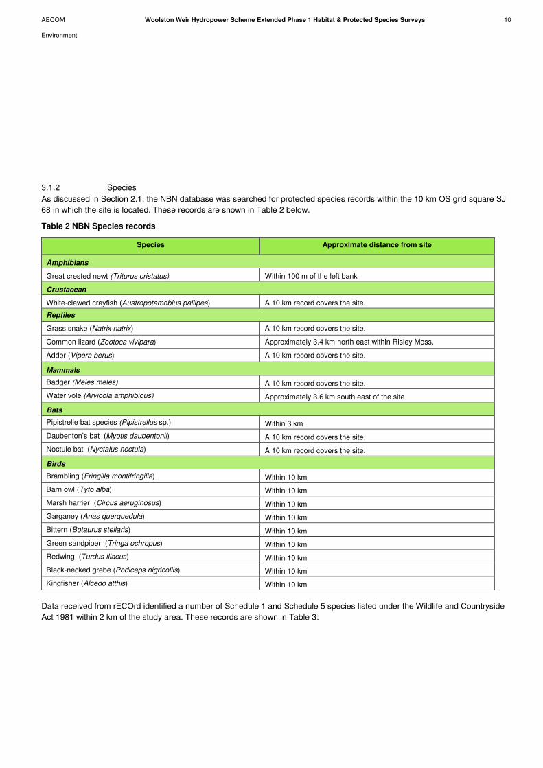
AECOM Woolston Weir Hydropower Scheme Extended Phase 1 Habitat & Protected Species Surveys 10
Environment
3.1.2 Species
As discussed in Section 2.1, the NBN database was searched for protected species records within the 10 km OS grid square SJ
68 in which the site is located. These records are shown in Table 2 below.
Table 2 NBN Species records
Data received from rECOrd identified a number of Schedule 1 and Schedule 5 species listed under the Wildlife and Countryside
Act 1981 within 2 km of the study area. These records are shown in Table 3:
Species Approximate distance from site
Amphibians
Great crested newt (Triturus cristatus) Within 100 m of the left bank
Crustacean
White-clawed crayfish (Austropotamobius pallipes) A 10 km record covers the site.
Reptiles
Grass snake (Natrix natrix) A 10 km record covers the site.
Common lizard (Zootoca vivipara) Approximately 3.4 km north east within Risley Moss.
Adder (Vipera berus) A 10 km record covers the site.
Mammals
Badger (Meles meles) A 10 km record covers the site.
Water vole (Arvicola amphibious) Approximately 3.6 km south east of the site
Bats
Pipistrelle bat species (Pipistrellus sp.) Within 3 km
Daubenton’s bat (Myotis daubentonii) A 10 km record covers the site.
Noctule bat (Nyctalus noctula) A 10 km record covers the site.
Birds
Brambling (Fringilla montifringilla) Within 10 km
Barn owl (Tyto alba) Within 10 km
Marsh harrier (Circus aeruginosus) Within 10 km
Garganey (Anas querquedula) Within 10 km
Bittern (Botaurus stellaris) Within 10 km
Green sandpiper (Tringa ochropus) Within 10 km
Redwing (Turdus iliacus) Within 10 km
Black-necked grebe (Podiceps nigricollis) Within 10 km
Kingfisher (Alcedo atthis) Within 10 km
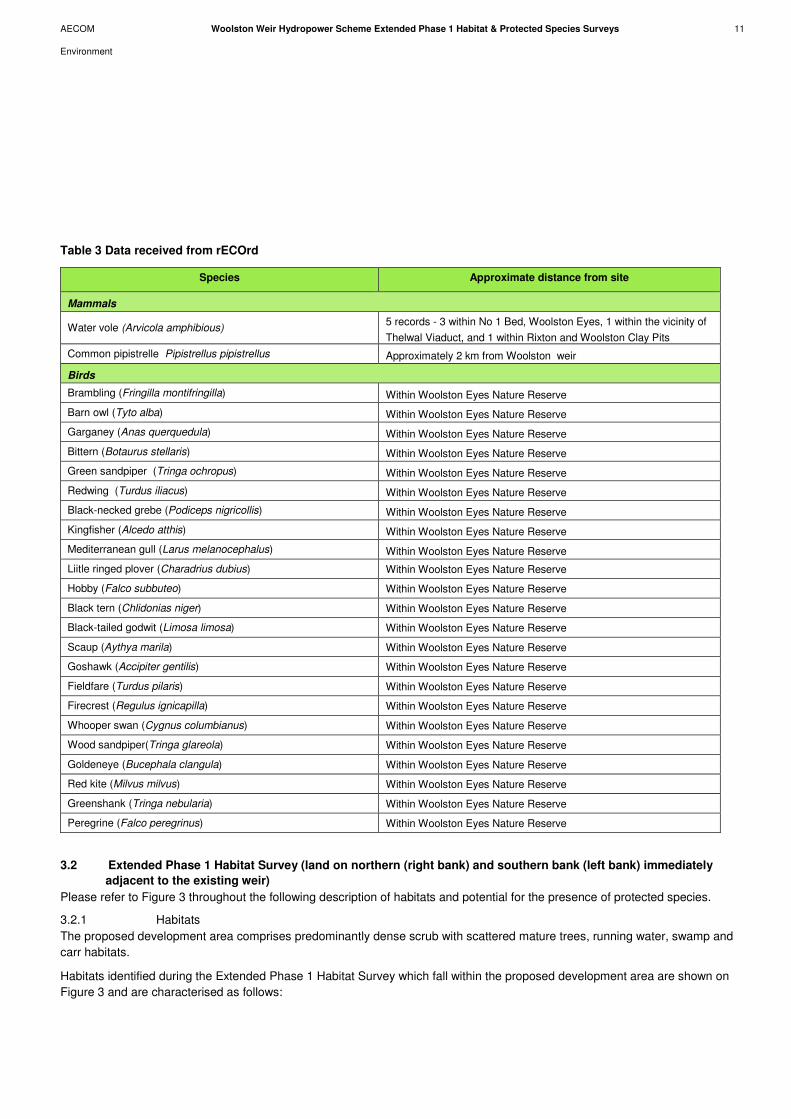
AECOM Woolston Weir Hydropower Scheme Extended Phase 1 Habitat & Protected Species Surveys 11
Environment
Table 3 Data received from rECOrd
3.2 Extended Phase 1 Habitat Survey (land on northern (right bank) and southern bank (left bank) immediately
adjacent to the existing weir)
Please refer to Figure 3 throughout the following description of habitats and potential for the presence of protected species.
3.2.1 Habitats
The proposed development area comprises predominantly dense scrub with scattered mature trees, running water, swamp and
carr habitats.
Habitats identified during the Extended Phase 1 Habitat Survey which fall within the proposed development area are shown on
Figure 3 and are characterised as follows:
Species Approximate distance from site
Mammals
Water vole (Arvicola amphibious) 5 records - 3 within No 1 Bed, Woolston Eyes, 1 within the vicinity of
Thelwal Viaduct, and 1 within Rixton and Woolston Clay Pits
Common pipistrelle Pipistrellus pipistrellus Approximately 2 km from Woolston weir
Birds
Brambling (Fringilla montifringilla) Within Woolston Eyes Nature Reserve
Barn owl (Tyto alba) Within Woolston Eyes Nature Reserve
Garganey (Anas querquedula) Within Woolston Eyes Nature Reserve
Bittern (Botaurus stellaris) Within Woolston Eyes Nature Reserve
Green sandpiper (Tringa ochropus) Within Woolston Eyes Nature Reserve
Redwing (Turdus iliacus) Within Woolston Eyes Nature Reserve
Black-necked grebe (Podiceps nigricollis) Within Woolston Eyes Nature Reserve
Kingfisher (Alcedo atthis) Within Woolston Eyes Nature Reserve
Mediterranean gull (Larus melanocephalus) Within Woolston Eyes Nature Reserve
Liitle ringed plover (Charadrius dubius) Within Woolston Eyes Nature Reserve
Hobby (Falco subbuteo) Within Woolston Eyes Nature Reserve
Black tern (Chlidonias niger) Within Woolston Eyes Nature Reserve
Black-tailed godwit (Limosa limosa) Within Woolston Eyes Nature Reserve
Scaup (Aythya marila) Within Woolston Eyes Nature Reserve
Goshawk (Accipiter gentilis) Within Woolston Eyes Nature Reserve
Fieldfare (Turdus pilaris) Within Woolston Eyes Nature Reserve
Firecrest (Regulus ignicapilla) Within Woolston Eyes Nature Reserve
Whooper swan (Cygnus columbianus) Within Woolston Eyes Nature Reserve
Wood sandpiper(Tringa glareola) Within Woolston Eyes Nature Reserve
Goldeneye (Bucephala clangula) Within Woolston Eyes Nature Reserve
Red kite (Milvus milvus) Within Woolston Eyes Nature Reserve
Greenshank (Tringa nebularia) Within Woolston Eyes Nature Reserve
Peregrine (Falco peregrinus) Within Woolston Eyes Nature Reserve
AECOM Woolston Weir Hydropower Scheme Extended Phase 1 Habitat & Protected Species Surveys 12
Environment
3.2.2 Scrub and Carr
This habitat is present on the right bank of the weir, located between the weir itself and the residential estate to the north. This
habitat extends westwards from Weir Lodge through to the channel to the west of the weir and represents an intermediate stage
between wetland and wet woodland and grades into open swamp to willow carr woodland. The scrub component of this habitat
was dominated by typical species including bramble Rubus fruticosus and young goat willow Salix caprea, oak Quercus sp. and
silver birch Betula pendula.
The swamp areas (TN1) are dominated by reed canary-grass Phalaris arundinacea, common reed Phragmites australis and rush
Juncus sp (refer to Photograph 1 in Appendix F).
A narrow linear strip of scrub is also present between the River Mersey and the track leading to the weir. This habitat is
dominated by bramble.
The entire left bank of the weir is almost entirely dominated by scrub habitat (refer to photograph 2 in Appendix F). Typical
species in the area include bramble, young silver birch, alder Alnus glutinosa and goat willow along the bank of the River Mersey.
Small stands of reed canary-grass are also present in this area.
3.2.3 Scattered Trees
There are mature and semi-mature trees on the western perimeter of Weir Lodge bordering the scrub and carr habitat (TN6).
Species include Lombardy poplar Populus nigra var. italica, goat willow and alder. A number of mature silver birch are also
present bordering the channel to the west of the weir. On the left bank of the River Mersey semi-mature trees include alder, goat
willow and white poplar Populus alba.
3.2.4 Running Water
Woolston Weir is a large water control structure built in the mid-1990’s and is located approximately 1 km west of the M6 towards
the upper reaches of the River Mersey. The River Mersey enters the Manchester Ship Canal at Irlam and exits at Rixton within
the Latchford Pond. Woolston Weir is a concrete structure spanning the width of the River Mersey with a pool and weir fish pass
located alongside the weir on the right bank
3.2.5 Standing Open Water
Small bodies of open water are present in the scrub and carr habitat to the north of the weir. A large lagoon is also known to be
present on the island to the south of the weir. The latter was inaccessible at the time of the survey.
3.3 Protected Faunal Species Assessment
The Extended Phase 1 Habitat Survey identified habitats and features suitable for the support of protected species. An
assessment of the habitats for each of the species is made within this section. Where no habitats or features were identified
which were suitable to support protected/notable species, or a lack of evidence of the presence of these species was recorded at
the site, these have been excluded from discussion within this report.
3.3.1 Bats
All trees on the right and left banks of River Mersey immediately adjacent to the weir were subject to a preliminary assessment
for their potential to support roosting bats. None of these trees were considered to offer any suitable features for roosting bats.
In terms of the site’s potential value for foraging, the riparian habitat surrounding the weir is likely to provide good foraging
habitat, however the proposed hydropower development will not result in significant loss of riparian habitat and therefore, will
notadversely impact upon bats.
3.3.2 Badger
No conclusive evidence of badger was found in the scrub and carr habitat to the north of the weir, although a mammal track was
identified in this area. It was not possible to determine whether the track had been created by badger or fox due to an absence of
prints and hairs. Evidence of badger activity in the form of runs and latrines was identified on the south bank (TN 3 & 4).
3.3.3 Breeding Birds
Vegetation present within the survey area, including areas of scrub and scattered trees, is suitable for use by nesting birds such
as common hedgerow passerines (tits, finches etc). During the Extended Phase 1 Habitat Survey, common species of bird

AECOM Woolston Weir Hydropower Scheme Extended Phase 1 Habitat & Protected Species Surveys 13
Environment
including great tit Parus major, blue tit Cyanistes caeruleus, long-tailed tit Aegithalos caudatus, and blackbird Turdus merula
were observed close to the dense scrub and carr habitats north of the weir. Given the proximity of the site to Woolston Eyes
SSSI, the areas of swamp and marginal vegetation may also be used for foraging by water birds such as little grebe Tachybaptus
ruficollis, great crested grebe Podiceps cristatus, and mute swan Cygnus olor. Areas of swamp and reedbed may also be used
by species such as grasshopper warbler Locustella naevia, sedge warbler Acrocephalus schoenobaenus, reed warbler
Acrocephalus scirpaceus and reed bunting Emberiza schoeniclus. Woolston Eyes SSSI supports a nationally important
assemblage of breeding birds.
It is considered highly unlikely that there will be any operational effects of the proposed development on birds, particularly when considered against the baseline conditions of an operational weir, and we consider at this point that there is no need for further baseline surveys. However, there still exists the potential for construction and the site clearance preceding it to have an adverse impact on breeding birds through habitat loss and damage to nests. It is therefore suggested that a combination of some or all of the following conditions are included within the scheme:
- Clearance of vegetation outside of the bird breeding season (i.e. not between March and July inclusive);
- Re-planting of vegetation post construction to mitigate habitat loss according to a planting scheme to be agreed in advance of
works; and
- Checks of vegetation for nesting birds immediately prior to clearance and standoffs around nests imposed to protect them
from construction damage until young have fledged.
3.3.4 Invasive Plant Species
No Indian balsam, Japanese knotweed or giant hogweed was detected within the proposed footprint of the works during the
invasive species survey. Occasional individual giant hogweed plants were identified on the left bank of the River Mersey (TN5)
which would not be touched by the proposed development. This species is known to be abundant within the Woolston Eyes SSSI
and surrounding area. However, it has not been found at the proposed hydropower development site or associated grid
connection route options.
3.3.5 Great Crested Newt Habitat Suitability Index Assessments
During the Phase 1 Habitat survey the areas of carr habitat immediately adjacent to the proposed working area (TN8) was
assessed as offering breeding and foraging opportunities for great crested newt, and it was therefore recommended that this
area was subject to an HSI survey. During the HSI and badger survey, parts of this habitat had completely dried out, however
there was an area that still contained standing water (see Photograph 5 in Appendix F). Table 4 below presents the findings of
the HSI score for the remaining waterbody:
Table 4 HSI results
Pond Number HSI Score Range Suitability
1 0.57 >0.5 Below average
As the area of swamp habitat received an HSI of above 0.5 it was considered prudent to undertake further presence / absence
surveys in this area. Although the suitability was calculated as below average, it is worth noting that as the habitat is not an actual
pond, it is not possible to apply certain methods of evaluation accurately, which may have underestimated the suitability of this
area as potential great crested newt breeding habitat.
3.3.6 Great Crested Newt Presence / Absence Surveys
Following the initial GCN Habitat Suitability Index assessment, GCN presence / absence surveys were carried out on the
waterbody. Three surveys were undertaken in May 2012 using three survey techniques: netting, egg searching and torching. It
was not possible to set traps due to the shallow depth of water.
No GCN or eggs were noted over the three survey visits, although a number of toads were observed. Throughout the two week
survey period, the waterbody continued to recede and eventually stagnated. Consequently, a fourth survey was not possible due
poor water quality affecting visibility and inaccessibility of the remaining standing water. The quality of the water was considered
too poor to support GCN egg and larval development or a sufficient diversity of aquatic invertebrates to provide a sustainable

AECOM Woolston Weir Hydropower Scheme Extended Phase 1 Habitat & Protected Species Surveys 14
Environment
food source. Typically, for the successful emergence of juveniles, breeding ponds must normally retain water until the end of
August. It was therefore concluded that this particular waterbody does not offer suitable breeding habitat for great crested newt.
3.3.7 Water Vole
No evidence of water vole was identified at the proposed development site or associated grid connection route options during
the water vole survey conducted in April 2012.
3.3.8 Otter
No evidence of otter was identified at the proposed development site or associated grid connection route options during the otter
survey conducted in April 2012.
3.4 Extended Phase 1 Habitat Survey (Grid Connection Option 1)
3.4.1 Habitats
Habitats located within and immediately adjacent to Grid Connection Option1 comprise hardstanding, scrub, semi-mature trees
and hedgerows. Habitats identified during the Extended Phase 1 Habitat Survey are shown on Figure 2 and are characterised as
follows:
3.4.2 Hardstanding
The majority of the Grid Connection Option 1 is dominated by hardstanding in the form of Weir Lane, Edward Gardens and
aligning public footpaths.
3.4.3 Scrub
A linear strip of scrub habitat is present on the northern bank of the River Mersey opposite Lock Cottage. This habitat is
dominated by bramble.
3.4.4 Semi-mature Trees
A number of semi-mature trees are present in the roadside verges located along parts of Weir Lane and along the northern
banks of the River Mersey opposite Lock Cottage. Species recorded included sycamore Acer pseudoplatanus. and willow Salix
sp.
3.4.5 Hedgerows
Species-poor hedgerows are present in the small sections of roadside verge located along parts of Weir Lane. Typical species
included hawthorn Crataegus monogyna and holly Ilex aquifolium. Sections of these hedgerows form the boundary between Weir
Lane and private gardens.
Protected Faunal Species Assessment (Grid Connection Option 1)
3.4.6 Breeding Birds
Sections of hedgerow, areas of scrub and scattered semi-trees aligning Weir Lane and opposite Lock Cottage provide habitat for
nesting birds such as common hedgerow passerines (tits, finches etc).
3.4.7 Bats
It is possible that bats use the river corridor as a commuting and foraging route, however no mature trees with the potential to
support roosting bats were noted along the connection route.
3.4.8 Badger
As discussed in Section 3.3.2, a mammal track was noted amongst the vegetation on the north bank. It was not possible to
determine which species created the track due to the absence of additional field signs such as prints and hairs, however, no
badger setts were identified within 30 m of the works. In addition, a large proportion of the works associated with this cable route
option fall within an area of hard standing, which does not provide habitat for this species.
AECOM Woolston Weir Hydropower Scheme Extended Phase 1 Habitat & Protected Species Surveys 15
Environment
3.5 Extended Phase 1 Habitat Survey (Grid Connection Option 2)
3.5.1 Habitats
Habitats located within and immediately adjacent to Grid Connection Option 2 comprise scrub, semi-mature trees, tall ruderal,
improved grassland, marginal vegetation and a hedgerow.
Habitats identified during the Extended Phase 1 Habitat Survey are shown on Figure 3 and are characterised as follows:
3.5.2 Scattered Scrub
Small patches of scrub habitat were noted on the northern (right bank) adjoining the towpath. This habitat is dominated by
bramble.
3.5.3 Semi-mature trees
A number of semi-mature trees were noted aligning the footpath which runs parallel to the River Mersey towards Thelwall
Viaduct. Species recorded include sycamore Acer pseudoplatanus, Cypress sp, oak Quercus sp, and pine Pinus sp.
(Photographs 3 & 4).
3.5.4 Tall Ruderal
Stands of tall ruderal habitat were noted on the northern (right bank) interspersed with the scrub habitat. Typical species include
bracken Pteridium aquilinum, nettle Urtica dioica, cow parsley Anthriscus sylvestris, rosebay willowherb Epilobium angustifolium
and cleavers Galium aparine.
3.5.5 Amenity Grassland
Grid connection option 2 will break away from the towpath and head north through an area of amenity grassland. This grassland
is of little ecological value due to its regular mowing and it is likely to be used for recreational purposes.
3.5.6 Marginal Vegetation
Small narrow bands of emergent vegetation are present on the northern margin of the River Mersey. Species recorded include
reed canary-grass and Typha sp.
3.5.7 Hedgerow
Sections of species poor hedgerow are present along the northern side of the towpath often forming a boundary between the
towpath and private gardens. Species recorded include hawthorn and holly. These hedgerows were often accompanied by a
basal flora including hybrid bluebell Hyacinthoides x massartiana, lesser celandine Ranunculus ficaria and garlic mustard Alliaria
petiolata.
3.6 Protected Faunal Species Assessment (Grid Connection Option 2)
3.6.1 Breeding Birds
The hedgerows, scrub habitats, and semi-mature trees adjoining the towpath provide habitat for nesting birds such as common
hedgerow passerines (tits, finches etc). Specific details of the survey relating to breeding birds can be found in Appendix G.
3.6.2 Bats
None of the trees observed along this potential route option were considered suitable for roosting bats. Bats may potentially
forage along the rivers riparian habitats, but this habitat should not be affected by the works.
3.6.3 Badger
As previously discussed, conclusive evidence of badger in the form of runs and latrines was identified on the southern bank of
the river only (TN 3 & 4). Further east along the towpath, beyond Weir Lane, there is less available habitat for sett construction. It
is possible that badger forage in this area ,however no evidence was identified during the survey.

AECOM Woolston Weir Hydropower Scheme Extended Phase 1 Habitat & Protected Species Surveys 16
Environment
4.1 General Protection Measures
Best practice should be followed regarding works on site to minimise any unanticipated adverse impact on habitats and species.
Therefore it is recommended that the client should consider using contractors who are committed to the ‘Considerate
Constructors Scheme’ (http://www.ccscheme.org.uk). Further to this, it is recommended that the site supervisor should have a
copy of ‘Working with Wildlife, compliance and beyond in construction’ published by CIRIA. The Site Manager and Foreman
should be acquainted with this document and be able to advise the workforce on its contents. All site staff should be briefed on
any ecological issues affecting the site, the mitigation implemented and methods of working adopted as part of best practice. A
Construction Environmental Management Plan (CEMP) should be submitted with the planning application.
It is considered that potential adverse impacts can be minimised and managed through a combination of habitat management,
timing of works and ecological supervision. It is recommended that mitigation measures are proposed within supporting
documentation to the planning application as necessary.
4.2 Further Surveys and Mitigation (land on northern bank (right bank) and southern bank (left bank) immediately
adjacent to the existing weir)
4.2.1 Habitats
4.2.1.1 Mature trees
It is recommended that where feasible and practicable to do so, the small number of mature trees that feature immediately west
of Weir Lodge perimeter are retained and their Root Protection Zones (RPZ) protected. Any works within close proximity to trees
RPZ should conform to National Joint Utilities Group (NJUG) or Guidelines BS 5837: 2012 Trees in Relation to Design,
Demolition and Construction.
4.2.1.2 Watercourses
Run-off from the study area during construction should be managed in accordance with current Environment Agency regulations
and should reduce the potential for transmission of particulates and pollutants into any watercourses, such as the ponds to the
north of the site.
4.2.1.3 Scrub and Carr Habitat
It is recommended that encroachment into the areas of scrub and carr and associated intermediate habitats is minimised as
much as possible, to maximise habitat available to nesting birds, invertebrates and amphibians such as common toad and
common frog.
4.2.2 Designated Sites
The current scope of the proposed development will not directly or indirectly impact upon Woolston Eyes SSSI. Should this
change then any works within Woolston Eyes SSSI will require an Assent to Work from Natural England. This will require prior
agreement for exact construction methodologies that must be adhered to on site. The locally designated sites at Partington
Meadows LNR and Woolston New Cut SINC are more than 1km from the site and will not be impacted by this proposed
development.
4.2.3 Species
4.2.3.1 Birds
It is considered highly unlikely that there will be any operational effects of the proposed development on birds, particularly when
considered against the baseline conditions of an operational weir, and it is considered at this point that there is no need for
further baseline surveys. However, there is the potential for construction and the site clearance to have an adverse impact on
breeding birds through habitat loss and damage to nests. It is therefore suggested that a combination of some or all of the
following conditions are included within the scheme:
- Clearance of vegetation outside of the bird breeding season (i.e. not between March and July inclusive);
4 Further Surveys and Recommendations
AECOM Woolston Weir Hydropower Scheme Extended Phase 1 Habitat & Protected Species Surveys 17
Environment
- Re-planting of vegetation post construction to mitigate habitat loss according to a planting scheme to be agreed in advance
of works; and
- Checks of vegetation by a competent person for nesting birds immediately prior to clearance and stand-off’s around nests
imposed to protect them from construction damage until young have fledged.
Full details of the Breeding Bird Survey can be found in the Woolston Weir Breeding Bird Survey Interim Technical Note in
Appendix G.
4.2.3.2 Great Crested Newts and Amphibians
As discussed in Section 3.8.3, the waterbody on the northern bank to the north of the weir does not offer suitable breeding
habitat for great crested newt and therefore no mitigation will be required. However, common toad Bufo bufo, which is a UK
Biodiversity Action Plan (BAP) Species, was recorded during the GCN surveys. The common toad should be considered during
site clearance and excavations, with any individuals discovered during vegetation removal or excavations relocated out of harm’s
way. Staged strimming of rough grassland and scrub and subsequent habitat degradation may encourage any toads present out
of the working area.
4.2.3.3 Badger
No badger setts have been detected within 30 m of the proposed hydropower development site or the associated grid connection
options during the badger survey in April 2012. However, as a mammal track was identified along the bund on the northern bank,
it is recommended that a precautionary pre-construction survey should be undertaken if works have not commenced by spring
2013 (i.e. March / April). In addition, should night work be required then all artificial lighting should be avoided wherever possible
to reduce the impact upon foraging or commuting badgers in the area. If artificial lighting is essential, it should be designed as
task specific directional lighting and installed carefully to light working areas without causing light spill onto the surrounding areas.
Operational lighting should be minimised and designed to prevent unnecessary light spill, with consideration given to illumination
timings of street lights that would turn off the lighting during the middle of the night when it is not required.
Should it be necessary to leave any excavations open overnight then minor mitigation measures should be implemented to
prevent badgers becoming trapped within excavations. This may include back filling small trenches each day, covering
excavations left open overnight, or providing simple escape routes out of larger excavations (for example planks of wood), or a
battered back escape route from an excavation. Protective fencing may be required around any deeper excavations in order to
prevent badger from falling within unless all sides can be battered back as slopes.
In summary, a Natural England badger disturbance licence will be required for any activity that does not meet the following
conditions:
- That there will be no harm to the badgers themselves or damage to the sett(s);
- No disturbance of the badgers (above existing levels); and
- No isolation, fragmentation or severance of the badger territory, and that access is maintained between the sett and all other
areas of a territory.
At this stage there is no evidence to suggest that the works will have an adverse effect on badger and as such there is no
requirement for a licence. Should a pre-construction survey find evidence that the works will have a significant impact on this
species; a licence application would need to be submitted.
4.2.4 Water Vole
No further mitigation is required for water vole.
4.2.5 Otter
No further mitigation is required for otter.
4.2.6 Controlled Species
No controlled plant species were observed during the invasive species survey on the north bank adjacent to the towpath and
therefore, no further mitigation will be required.

AECOM Woolston Weir Hydropower Scheme Extended Phase 1 Habitat & Protected Species Surveys 18
Environment
4.3 Further Surveys and Mitigation (Grid Connection Option 1)
4.3.1 Breeding Birds
It is understood that works associated with this cable route would not require the removal of any trees or sections of hedgerow
however, some minor trimming of vegetation may be required. To avoid potential disturbance to common passerines such as tits
and finches, it is recommended for any vegetation trimming/removal to be undertaken outside of the main breeding bird season
(i.e. not between March and July inclusive). If this is not possible, a nesting bird check should be undertaken by an ecologist
immediately before the onset of works to establish if any nesting birds are present. In areas that are inaccessible due to the
density of the vegetation, it may be necessary to undertake the nest search in conjunction with vegetation clearance to permit
access into dense areas of scrub. Appropriate mitigation can then be formulated if necessary, such as exclusion zones.
4.4 Further Surveys and Mitigation (Grid Connection Option 2)
4.4.1 Breeding Birds
Again, it is understood that works associated with this cable route would not require the removal of any trees or sections of
hedgerow however, some minor trimming of vegetation may be required. To avoid potential disturbance to common passerines
such as tits and finches, it is recommended for any vegetation trimming/removal to be undertaken outside of the main breeding
bird season (i.e not between March and July inclusive). If this is not possible, a nesting bird check should be undertaken by an
ecologist immediately before the onset of works to establish if any nesting birds are present. In areas that are inaccessible due to
the density of the vegetation, it may be necessary to undertake the nest search in conjunction with vegetation clearance to permit
access into dense areas of scrub. Appropriate mitigation can then be formulated if necessary, such as exclusion zones.
4.4.2 Invasive Plant Species
No invasive plant species were detected during the invasive species survey on the north bank adjacent to the towpath and
therefore, no further mitigation will be required.
4.4.3 Semi-mature Trees
It is recommended that where feasible and practicable to do so, the small numbers of [semi-mature?] trees that feature along the
towpath are retained and their Root Protection Zones (RPZ) protected. Any works within close proximity to trees RPZ should
conform to National Joint Utilities Group (NJUG) or Guidelines BS 5837: 2012 Trees in Relation to Design, Demolition and
Construction.
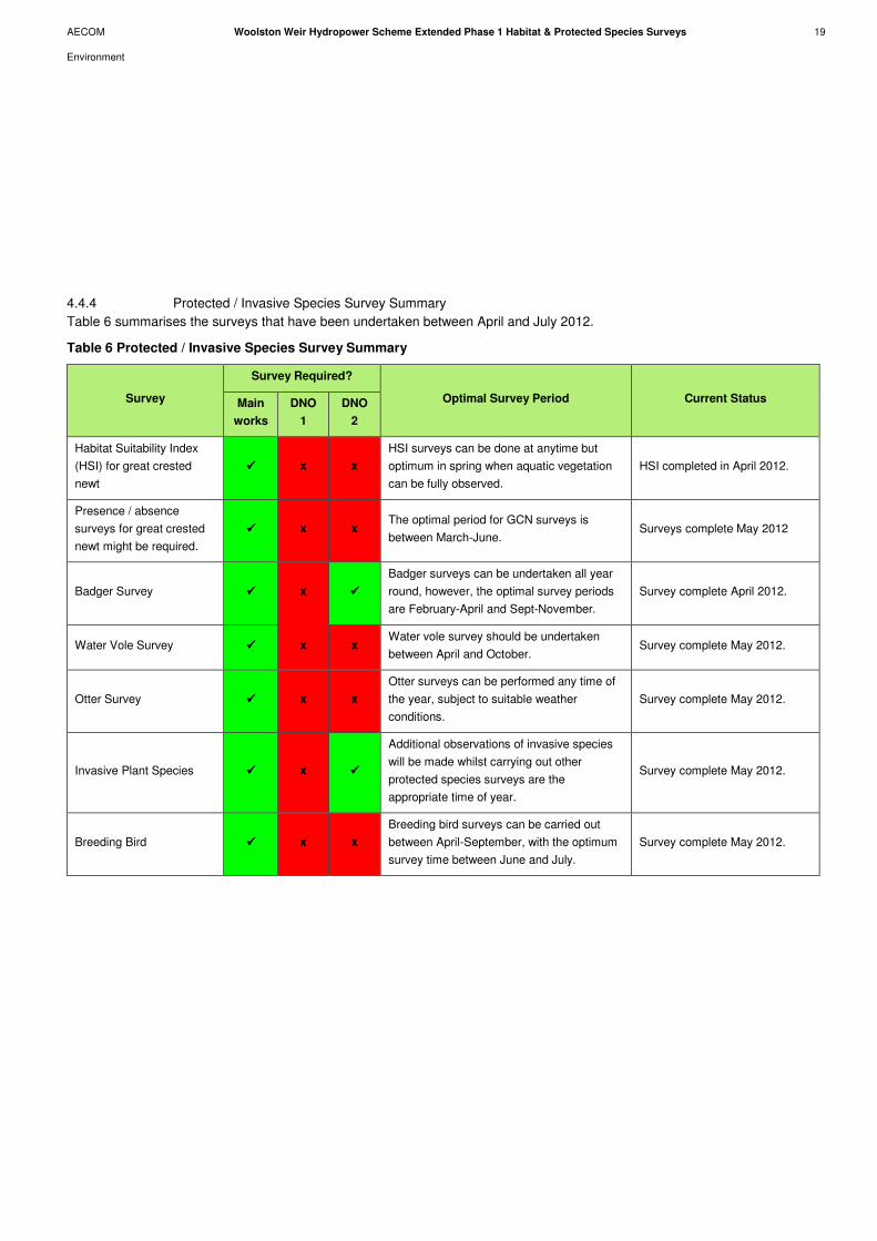
AECOM Woolston Weir Hydropower Scheme Extended Phase 1 Habitat & Protected Species Surveys 19
Environment
4.4.4 Protected / Invasive Species Survey Summary
Table 6 summarises the surveys that have been undertaken between April and July 2012.
Table 6 Protected / Invasive Species Survey Summary
Survey
Survey Required?
Optimal Survey Period Current Status Main
works
DNO
1
DNO
2
Habitat Suitability Index
(HSI) for great crested
newt
���� x x
HSI surveys can be done at anytime but
optimum in spring when aquatic vegetation
can be fully observed.
HSI completed in April 2012.
Presence / absence
surveys for great crested
newt might be required.
���� x x The optimal period for GCN surveys is
between March-June. Surveys complete May 2012
Badger Survey ���� x ����
Badger surveys can be undertaken all year
round, however, the optimal survey periods
are February-April and Sept-November.
Survey complete April 2012.
Water Vole Survey ���� x x Water vole survey should be undertaken
between April and October. Survey complete May 2012.
Otter Survey ���� x x
Otter surveys can be performed any time of
the year, subject to suitable weather
conditions.
Survey complete May 2012.
Invasive Plant Species ���� x ����
Additional observations of invasive species
will be made whilst carrying out other
protected species surveys are the
appropriate time of year.
Survey complete May 2012.
Breeding Bird ���� x x
Breeding bird surveys can be carried out
between April-September, with the optimum
survey time between June and July.
Survey complete May 2012.
AECOM Woolston Weir Hydropower Scheme Extended Phase 1 Habitat & Protected Species Surveys 20
Environment
Documents:
British Standard (BS) 5837:2012 Trees in relation to design, demolition and construction – Recommendations (2012).
Department of the Environment (1995) Biodiversity: The UK Steering Group Report – Volume 2: Action plans.
Edgar, P. and Griffiths, A. (2004). An evaluation of the effectiveness of great crested newt Triturus cristatus mitigation projects in England, 1990-2001. English Nature Research Report 575. English Nature. Peterborough.
English Nature (2001) Great Crested Newt Mitigation Guidelines.
Environment Agency (2009) Woolston Weir, River Mersey (SJ 6521 8866) Fish Pass Feasibility Study.
HMSO (2010) The Conservation of Habitats and Species Regulations 2010.
HMSO (1981) The Wildlife and Countryside Act 1981 (as amended).
Institute of Environmental Assessment (1995) Guidelines for Baseline Ecological Assessment.
Joint Nature Conservation Committee (2003) Herpetofauna Workers’ Manual.
Joint Nature Conservation Committee (2010) Handbook for Phase 1 Habitat Survey: A technique for environmental audit.
National Joint Utilities Group (NJUG) Guidelines for the Planning, Installation and Maintenance of Utility Apparatus in Proximity to
Trees- Issue 2 (2007).
Strachan R. and Moorhouse T (2006) Water Vole Conservation Handbook. Second Edition.
Woods, M. (1995) The Badger. The Mammal Society, London.
Websites:
http://www.magic.defra.gov.uk/website/magic/ (MAGIC map).
http://www.naturalengland.org.uk/ (Natural England).
http://www.ukbap-reporting.org.uk/ (Biodiversity Action Reporting System website).
http://www.cheshire-biodiversity.org.uk/ (Cheshire Region BAP).
http://www.woolstoneyes.co.uk/ (The Woolston Eyes Conservation Group).
References

AECOM Woolston Weir Hydropower Scheme Extended Phase 1 Habitat & Protected Species Surveys
Environment
Figure 1 Grid Connection Route Options

Client:
Project:
Title:
A4
cm
No.
App'd:
Design:
Scale:
GIS:
Chk'd:
Date:
Rev:
www.aecom.comFax: +44 (0) 161 927 8499Tel: +44 (0) 161 927 8200AECOM House, 179 Moss Lane,
Altrincham, WA15 8FH
"This document has been prepared by AECOM Ltd ("AL") for the sole use of our Client (the "Client") and in accordance with generally accepted consultancy principles, the budget for fees and the terms of reference agreed between AL and the Client. Anyinformation provided by third parties and referred to herein has not been checked or verified by AL, unless otherwise expressly stated in the document. No third party may rely upon this document without the prior and express written agreement of AL"
cm
NL
CSu
NTS @A4
FT
NL
April 2012
FIGURE 1 1
PEEL ENERGY LTD
WOOLSTON WEIR HYDROPOWERSCHEME
GRID CONNECTION ROUTE OPTIONS
Legend
Approximate HEP Scheme Location
Grid ConnectionRoute Option 2
Grid ConnectionRoute Option 1
Liverpoolemail
New Stamp

AECOM Woolston Weir Hydropower Scheme Extended Phase 1 Habitat & Protected Species Surveys
Environment
Figure 2 Nature Conservation Designations Map
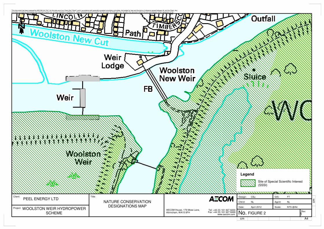
Client:
Project:
Title:
A4
cm
No.
App'd:
Design:
Scale:
GIS:
Chk'd:
Date:
Rev:
www.aecom.comFax: +44 (0) 161 927 8499Tel: +44 (0) 161 927 8200AECOM House, 179 Moss Lane,
Altrincham, WA15 8FH
"This document has been prepared by AECOM Ltd ("AL") for the sole use of our Client (the "Client") and in accordance with generally accepted consultancy principles, the budget for fees and the terms of reference agreed between AL and the Client. Anyinformation provided by third parties and referred to herein has not been checked or verified by AL, unless otherwise expressly stated in the document. No third party may rely upon this document without the prior and express written agreement of AL"
cm
NL
CSu
NTS @A4
FT
NL
April 2012
FIGURE 2 1
PEEL ENERGY LTD
WOOLSTON WEIR HYDROPOWERSCHEME
NATURE CONSERVATIONDESIGNATIONS MAP
Legend
Site of Special Scientific Interest(SSSI)
Liverpoolemail
New Stamp

AECOM Woolston Weir Hydropower Scheme Extended Phase 1 Habitat & Protected Species Surveys
Environment
Figure 3 Extended Phase 1 Habitat Map
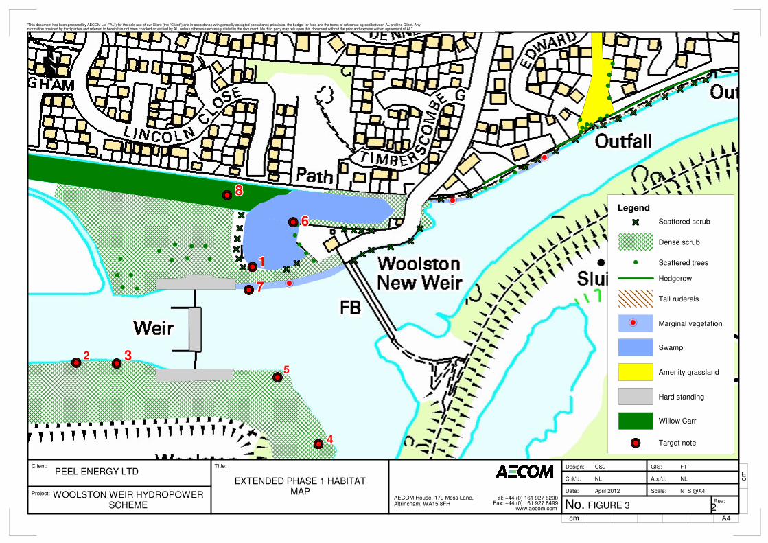
xxxxxxxxxxxxxxxxxxxxxxxxxxxxxxxxxxxxxxxxxxxxxxxxxxxxxxxxxxxxxxxxxxxxxxxxxxxxxxxxxxxxxxxxxxxxxxxxxxxxxxxxxxxxxxxxxxxxxxxxxxxxxxxxxxxxxxxxxxxxxxxxxxxxxxxxxxxxxxxxxxxxxxxxxxxxxxxxxxxxxxxxxxxxxxxxxxxxxxxxxxxxxxxxxxxxxxxxxxxxxxxxxxxxxxxxxxxxxxxxxxxxxxxxxxxxxxxxxxxxxxxxxxxxxxxxxxxxxxxxxxxxxxxxxxxxxxxxxxxxxxxxxxxxxxxxxxxxxxxxxxxxxxxxxxxxxxxxxxxxxxxxxxxxxxxxxxxxxxxxxxxxxxxxxxxxxxxxxxxxxxxxxxxxxxxxxxxxxxxxxxxxxxxxxxxxxxxxxxxxxxxxxxxxxxxxxxxxxxxxxxxxxxxxxxxxxxxxxxxxxxxxxxxxxxxxxxxxxxxxxxxxxxxxxxxxxxxxxxxxxxxxxxxxxxxxxxxxxxxxxxxxxxxxxxxxxxxxxxxxxxxxxxxxxxxxxxxxxxxxxxxxxxxxxxxxxxxxxxxxxxxxxxxx
xxxxxxxxxxxxxxxxxxxxxxxxxxxxxxxxxxxxxxxxxxxxxxxxxxxxxxxxxxxxxxxxxxxxxxxxxxxxxxxxxxxxxxxxxxxxxxxxxxxxxxxxxxxxxxxxxxxxxxxxxxxxxxxxxxxxxxxxxxxxxxxxxxxxxxxxxxxxxxxxxxxxxxxxxxxxxxxxxxxxxxxxxxxxxxxxxxxxxxxxxxxxxxxxxxxxxxxxxxxxxxxxxxxxxxxxxxxxxxxxxxxxxxxxxxxxxxxxxxxxxxxxxxxxxxxxxxxxxxxxxxxxxxxxxxxxxxxxxxxxxxxxxxxxxxxxxxxxxxxxxxxxxxxxxxxxxxxxxxxxxxxxxxxxxxxxxxxxxxxxxxxxxxxxxxxxxxxxxxxxxxxxxxxxxxxx
xxxxxxxxxxxxxxxxxxxxxxxxxxxxxxxxxxxxxxxxxxxxxxxxxxxxxxxxxxxxxxxxxxxxxxxxxxxxxxxxxxxxxxxxxxxxxxxxxxxxxxxxxxxxxxxxxxxxxxxxxxxxxxxxxxxxxxxxxxxxxxxxxxxxxxxxxxxxxxxxxxxxxxxxxxxxxxxxxxxxxxxxxxxxxxxxxxxxxxxxxxxxxxxxxxxxxxxxxxxxxxxxxxxxxxxxxxxxxxxxxxxxxxxxxxxxxxxxxxxxxxxxxxxxxxxxxxxxxxxxxxxxxxxxxxxxxxxxxxxxxxxxxxxxxxxxxxxxxxxxxxxxxxxxxxxxxxxxxxxxxxxxxxxxxxxxxxxxxxxxxxxxxxxxxxxxxxxxxxxxxxxxxxxxxxxx
xxxxxxxxxxxxxxxxxxxxxxxxxxxxxxxxxxxxxxxxxxxxxxxxxxxxxxxxxxxxxxxxxxxxxxxxxxxxxxxxxxxxxxxxxxxxxxxxxxxxxxxxxxxxxxxxxxxxxxxxxxxxxxxxxxxxxxxxxxxxxxxxxxxxxxxxxxxxxxxxxxxxxxxxxxxxxxxxxxxxxxxxxxxxxxxxxxxx
xxxxxxxxxxxxxxxxxxxxxxxxxxxxxxxxxxxxxxxxxxxxxxxxxxxxxxxxxxxxxxxxxxxxxxxxxxxxxxxxxxxxxxxxxxxxxxxxxxxxxxxxxxxxxxxxxxxxxxxxxxxxxxxxxxxxxxxxxxxxxxxxxxxxxxxxxxxxxxxxxxxxxxxxxxxxxxxxxxxxxxxxxxxxxxxxxxxx
xxxxxxxxxxxxxxxxxxxxxxxxxxxxxxxxxxxxxxxxxxxxxxxxxxxxxxxxxxxxxxxxxxxxxxxxxxxxxxxxxxxxxxxxxxxxxxxxxxxxxxxxxxxxxxxxxxxxxxxxxxxxxxxxxxxxxxxxxxxxxxxxxxxxxxxxxxxxxxxxxxxxxxxxxxxxxxxxxxxxxxxxxxxxxxxxxxxx
xxxxxxxxxxxxxxxxxxxxxxxxxxxxxxxxxxxxxxxxxxxxxxxxxxxxxxxxxxxxxxxxxxxxxxxxxxxxxxxxxxxxxxxxxxxxxxxxxxxxxxxxxxxxxxxxxxxxxxxxxxxxxxxxxxxxxxxxxxxxxxxxxxxxxxxxxxxxxxxxxxxxxxxxxxxxxxxxxxxxxxxxxxxxxxxxxxxx
xxxxxxxxxxxxxxxxxxxxxxxxxxxxxxxxxxxxxxxxxxxxxxxxxxxxxxxxxxxxxxxxxxxxxxxxxxxxxxxxxxxxxxxxxxxxxxxxxxxxxxxxxxxxxxxxxxxxxxxxxxxxxxxxxxxxxxxxxxxxxxxxxxxxxxxxxxxxxxxxxxxxxxxxxxxxxxxxxxxxxxxxxxxxxxxxxxxx
xxxxxxxxxxxxxxxxxxxxxxxxxxxxxxxxxxxxxxxxxxxxxxxxxxxxxxxxxxxxxxxxxxxxxxxxxxxxxxxxxxxxxxxxxxxxxxxxxxxxxxxxxxxxxxxxxxxxxxxxxxxxxxxxxxxxxxxxxxxxxxxxxxxxxxxxxxxxxxxxxxxxxxxxxxxxxxxxxxxxxxxxxxxxxxxxxxxx
xxxxxxxxxxxxxxxxxxxxxxxxxxxxxxxxxxxxxxxxxxxxxxxxxxxxxxxxxxxxxxxxxxxxxxxxxxxxxxxxxxxxxxxxxxxxxxxxxxxxxxxxxxxxxxxxxxxxxxxxxxxxxxxxxxxxxxxxxxxxxxxxxxxxxxxxxxxxxxxxxxxxxxxxxxxxxxxxxxxxxxxxxxxxxxxxxxxx xxxxxxxxxxxxxxxxxxxxxxxxxxxxxxxxxxxxxxxxxxxxxxxxxxxxxxxxxxxxxxxxxxxxxxxxxxxxxxxxxxxxxxxxxxxxxxxxxxxxxxxxxxxxxxxxxxxxxxxxxxxxxxxxxxxxxxxxxxxxxxxxxxxxxxxxxxxxxxxxxxxxxxxxxxxxxxxxxxxxxxxxxxxxxxxxxxxx xxxxxxxxxxxxxxxxxxxxxxxxxxxxxxxxxxxxxxxxxxxxxxxxxxxxxxxxxxxxxxxxxxxxxxxxxxxxxxxxxxxxxxxxxxxxxxxxxxxxxxxxxxxxxxxxxxxxxxxxxxxxxxxxxxxxxxxxxxxxxxxxxxxxxxxxxxxxxxxxxxxxxxxxxxxxxxxxxxxxxxxxxxxxxxxxxxxxxxxxxxxxxxxxxxxxxxxxxxxxxxxxxxxxxxxxxxxxxxxxxxxxxxxxxxxxxxxxxxxxxxxxxxxxxxxxxxxxxxxxxxxxxxxxxxxxxxxxxxxxxxxxxxxxxxxxxxxxxxxxxxxxxxxxxxxxxxxxxxxxxxxxxxxxxxxxxxxxxxxxxxxxxxxxxxxxxxxxxxxxxxxxxxxxxxxx xxxxxxxxxxxxxxxxxxxxxxxxxxxxxxxxxxxxxxxxxxxxxxxxxxxxxxxxxxxxxxxxxxxxxxxxxxxxxxxxxxxxxxxxxxxxxxxxxxxxxxxxxxxxxxxxxxxxxxxxxxxxxxxxxxxxxxxxxxxxxxxxxxxxxxxxxxxxxxxxxxxxxxxxxxxxxxxxxxxxxxxxxxxxxxxxxxxxxxxxxxxxxxxxxxxxxxxxxxxxxxxxxxxxxxxxxxxxxxxxxxxxxxxxxxxxxxxxxxxxxxxxxxxxxxxxxxxxxxxxxxxxxxxxxxxxxxxxxxxxxxxxxxxxxxxxxxxxxxxxxxxxxxxxxxxxxxxxxxxxxxxxxxxxxxxxxxxxxxxxxxxxxxxxxxxxxxxxxxxxxxxxxxxxxxxx
xxxxxxxxxxxxxxxxxxxxxxxxxxxxxxxxxxxxxxxxxxxxxxxxxxxxxxxxxxxxxxxxxxxxxxxxxxxxxxxxxxxxxxxxxxxxxxxxxxxxxxxxxxxxxxxxxxxxxxxxxxxxxxxxxxxxxxxxxxxxxxxxxxxxxxxxxxxxxxxxxxxxxxxxxxxxxxxxxxxxxxxxxxxxxxxxxxxxxxxxxxxxxxxxxxxxxxxxxxxxxxxxxxxxxxxxxxxxxxxxxxxxxxxxxxxxxxxxxxxxxxxxxxxxxxxxxxxxxxxxxxxxxxxxxxxxxxxxxxxxxxxxxxxxxxxxxxxxxxxxxxxxxxxxxxxxxxxxxxxxxxxxxxxxxxxxxxxxxxxxxxxxxxxxxxxxxxxxxxxxxxxxxxxxxxxxxxxxxxxxxxxxxxxxxxxxxxxxxxxxxxxxxxxxxxxxxxxxxxxxxxxxxxxxxxxxxxxxxxxxxxxxxxxxxxxxxxxxxxxxxxxxxxxxxxxxxxxxxxxxxxxxxxxxxxxxxxxxxxxxxxxxxxxxxxxxxxxxxxxxxxxxxxxxxxxxxxxxxxxxxxxxxxxxxxxxxxxxxxxxxxxxxxxxxxxxxxxxxxxxxxxxxxxxxxxxxxxxxxxxxxxxxxxxxxxxxxxxxxxxxxxxxxxxxxxxxxxxxxxxxxxxxxxxxxxxxxxxxxxxxxxxxxxxxxxxxxxxxxxxxxxxxxxxxxxxxxxxxxxxxxxxxxxxxxxxxxxxxxxxxxxxxxxxxxxxxxxxxxxxxxxxxxxxxxxxxxxxxxxxxxxx
xxxxxxxxxxxxxxxxxxxxxxxxxxxxxxxxxxxxxxxxxxxxxxxxxxxxxxxxxxxxxxxxxxxxxxxxxxxxxxxxxxxxxxxxxxxxxxxxxxxxxxxxxxxxxxxxxxxxxxxxxxxxxxxxxxxxxxxxxxxxxxxxxxxxxxxxxxxxxxxxxxxxxxxxxxxxxxxxxxxxxxxxxxxxxxxxxxxx
xxxxxxxxxxxxxxxxxxxxxxxxxxxxxxxxxxxxxxxxxxxxxxxxxxxxxxxxxxxxxxxxxxxxxxxxxxxxxxxxxxxxxxxxxxxxxxxxxxxxxxxxxxxxxxxxxxxxxxxxxxxxxxxxxxxxxxxxxxxxxxxxxxxxxxxxxxxxxxxxxxxxxxxxxxxxxxxxxxxxxxxxxxxxxxxxxxxx
xxxxxxxxxxxxxxxxxxxxxxxxxxxxxxxxxxxxxxxxxxxxxxxxxxxxxxxxxxxxxxxxxxxxxxxxxxxxxxxxxxxxxxxxxxxxxxxxxxxxxxxxxxxxxxxxxxxxxxxxxxxxxxxxxxxxxxxxxxxxxxxxxxxxxxxxxxxxxxxxxxxxxxxxxxxxxxxxxxxxxxxxxxxxxxxxxxxx
xxxxxxxxxxxxxxxxxxxxxxxxxxxxxxxxxxxxxxxxxxxxxxxxxxxxxxxxxxxxxxxxxxxxxxxxxxxxxxxxxxxxxxxxxxxxxxxxxxxxxxxxxxxxxxxxxxxxxxxxxxxxxxxxxxxxxxxxxxxxxxxxxxxxxxxxxxxxxxxxxxxxxxxxxxxxxxxxxxxxxxxxxxxxxxxxxxxx
xxxxxxxxxxxxxxxxxxxxxxxxxxxxxxxxxxxxxxxxxxxxxxxxxxxxxxxxxxxxxxxxxxxxxxxxxxxxxxxxxxxxxxxxxxxxxxxxxxxxxxxxxxxxxxxxxxxxxxxxxxxxxxxxxxxxxxxxxxxxxxxxxxxxxxxxxxxxxxxxxxxxxxxxxxxxxxxxxxxxxxxxxxxxxxxxxxxx
xxxxxxxxxxxxxxxxxxxxxxxxxxxxxxxxxxxxxxxxxxxxxxxxxxxxxxxxxxxxxxxxxxxxxxxxxxxxxxxxxxxxxxxxxxxxxxxxxxxxxxxxxxxxxxxxxxxxxxxxxxxxxxxxxxxxxxxxxxxxxxxxxxxxxxxxxxxxxxxxxxxxxxxxxxxxxxxxxxxxxxxxxxxxxxxxxxxx
xxxxxxxxxxxxxxxxxxxxxxxxxxxxxxxxxxxxxxxxxxxxxxxxxxxxxxxxxxxxxxxxxxxxxxxxxxxxxxxxxxxxxxxxxxxxxxxxxxxxxxxxxxxxxxxxxxxxxxxxxxxxxxxxxxxxxxxxxxxxxxxxxxxxxxxxxxxxxxxxxxxxxxxxxxxxxxxxxxxxxxxxxxxxxxxxxxxx
xxxxxxxxxxxxxxxxxxxxxxxxxxxxxxxxxxxxxxxxxxxxxxxxxxxxxxxxxxxxxxxxxxxxxxxxxxxxxxxxxxxxxxxxxxxxxxxxxxxxxxxxxxxxxxxxxxxxxxxxxxxxxxxxxxxxxxxxxxxxxxxxxxxxxxxxxxxxxxxxxxxxxxxxxxxxxxxxxxxxxxxxxxxxxxxxxxxxxxxxxxxxxxxxxxxxxxxxxxxxxxxxxxxxxxxxxxxxxxxxxxxxxxxxxxxxxxxxxxxxxxxxxxxxxxxxxxxxxxxxxxxxxxxxxxxxxxxxxxxxxxxxxxxxxxxxxxxxxxxxxxxxxxxxxxxxxxxxxxxxxxxxxxxxxxxxxxxxxxxxxxxxxxxxxxxxxxxxxxxxxxxxxxxxxxxx
(
(
((
(
(
(
(
(
(
((
(
(
(
(
((
(
(
(
(
(
(
(
(
(
(
(
(
(
(-------------------------------------------------
-------------------------------------------------
-------------------------------------------------
--------------------------------------------------------------------------------------------------
6666666666666666666666666666666666666666666666666
1111111111111111111111111111111111111111111111111
7777777777777777777777777777777777777777777777777
33333333333333333333333333333333333333333333333332222222222222222222222222222222222222222222222222
-------------------------------------------------5555555555555555555555555555555555555555555555555
-------------------------------------------------8888888888888888888888888888888888888888888888888
------------------------------------------------- 4444444444444444444444444444444444444444444444444
-
-
-
Client:
Project:
Title:
A4
cm
No.
App'd:
Design:
Scale:
GIS:
Chk'd:
Date:
Rev:
www.aecom.comFax: +44 (0) 161 927 8499Tel: +44 (0) 161 927 8200AECOM House, 179 Moss Lane,
Altrincham, WA15 8FH
"This document has been prepared by AECOM Ltd ("AL") for the sole use of our Client (the "Client") and in accordance with generally accepted consultancy principles, the budget for fees and the terms of reference agreed between AL and the Client. Anyinformation provided by third parties and referred to herein has not been checked or verified by AL, unless otherwise expressly stated in the document. No third party may rely upon this document without the prior and express written agreement of AL"
cm
NL
CSu
NTS @A4
FT
NL
April 2012
FIGURE 3 2
PEEL ENERGY LTD
WOOLSTON WEIR HYDROPOWERSCHEME
EXTENDED PHASE 1 HABITATMAP
-------------------------------------------------
(
xxxxxxxxxxxxxxxxxxxxxxxxxxxxxxxxxxxxxxxxxxxxxxxxxxxxxxxxxxxxxxxxxxxxxxxxxxxxxxxxxxxxxxxxxxxxxxxxxxxxxxxxxxxxxxxxxxxxxxxxxxxxxxxxxxxxxxxxxxxxxxxxxxxxxxxxxxxxxxxxxxxxxxxxxxxxxxxxxxxxxxxxxxxxxxxxxxxx
Legend
Target note
Willow Carr
Hard standing
Amenity grassland
Swamp
Marginal vegetation
Tall ruderals
Hedgerow
Scattered trees
Dense scrub
Scattered scrub
-
Liverpoolemail
New Stamp

AECOM Woolston Weir Hydropower Scheme Extended Phase 1 Habitat & Protected Species Surveys
Environment
Appendix A Scheme Information
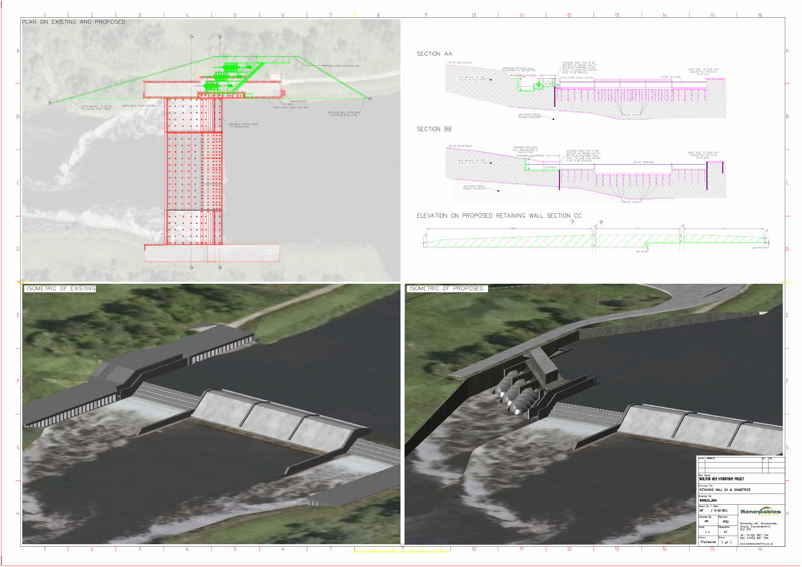
Rene ables
AECOM Woolston Weir Hydropower Scheme Extended Phase 1 Habitat & Protected Species Surveys
Environment
Detailed Species Specific Legislation
The following providers background information on the species specific legislation and policies relevant to the Woolston Weir site:
Bats
All European bats are listed in Annex IV of the EC Directive 92/94/EEC ‘The Conservation of Natural Habitats and of Wild Fauna
and Flora’ as being in need of “strict protection”. This is implemented in Britain under the Conservation of Habitats and Species
Regulations 2010. British bats are included under Schedule 5 of the Wildlife & Countryside Act, 1981 (as amended), and the
whole of Section 9 applies to European bat species. In summary, the above legislation prohibit the following:
- Deliberately, intentionally or recklessly kill, injure, disturb, catch, handle, possess or exchange a bat without a licence. A
‘deliberate’ offence may be committed by a person who did not intend to commit the offence, however they were sufficiently
informed and aware of the most likely consequences of the action. The offence of deliberately disturbing a bat applies
where the disturbance is likely to significantly influence: the ability of any significant population of bat to survive, breed or
rear or nurture their young, or the local distribution or abundance of the species;
- Damage or destroy a breeding site/resting place or intentionally damaging a place used for shelter (this applies to sites that
are not currently occupied, as bats can return to roosts year after year);
- Intentionally damage or obstruct access to any place that a bat uses for shelter or protection (i.e. a roost) without a licence;
and
- Keep, transport, sell or exchange, or offer for sale or exchange, any live or dead bat, or any part of, or anything derived
from a bat.
Licences are issued by Natural England for any actions that may compromise the protection of a European protected species,
including bats, under the Conservation of Habitats and Species Regulations 2010. This includes all developments and
engineering schemes, regardless of whether or not they require planning permission.
Birds
Birds are afforded varied protection and levels of conservation status on a species by species basis, with the inclusion of a
number of species under the following legislation or on lists of conservation concern:
- The Wildlife and Countryside Act, 1981 (as amended);
- EC Birds Directive, 1979;
- UK Biodiversity Action Plan (BAP) lists of globally threatened or declining species; and
- Royal Society for the Protection of Birds (RSPB) Red and Amber Birds of Conservation Concern (BoCC), 2009.
The most significant general legislation for breeding British birds lies within Part 1 of The Wildlife and Countryside Act, 1981 (as
amended). Under this legislation it is an offence to:
- Kill, injure or take any wild bird;
- Take, damage or destroy the nest of any wild bird while that nest is in use or being built; and
- Take or destroy an egg of any wild bird.
The above legislation effectively constrains any kind of development works from occurring that might have a detrimental effect to
nesting birds during the breeding season (which is between March and August for most species).
A number of British birds are considered to be declining or under threat and these species are included on lists of species of
conservation concern. The main criteria by which the RSPB (2009) defines Red List species include those whose breeding
population or range is rapidly declining (by 50% or more in the last 25 years), recently or historically, and those of global
conservation concern. Amber List species are those whose breeding population is in moderate decline (25 – 49% in the last 25
years), rare breeders, internationally important and localised species and those of unfavourable conservation status in Europe.
Many British bird species are listed as priority species on the UK BAP. Further information can be obtained at http://www.ukbap-
reporting.org.uk/plans/national.asp
Appendix B Species Specific Legislation and Policies
AECOM Woolston Weir Hydropower Scheme Extended Phase 1 Habitat & Protected Species Surveys
Environment
Great Crested Newt
Great crested newt is listed on Annex II and IV of the EC Directive 92/94/EEC ‘The Conservation of Natural Habitats and of Wild
Fauna and Flora’. This is implemented in Britain under the Conservation of Habitats and Species Regulations 2010. This
legislation prohibits the intentional killing of newts, the deliberate taking or destruction of eggs, damage or destruction of a
breeding site or resting place, intentional/reckless damage to or obstruction of a place used for shelter or protection, possession
of a great crested newt and any form of trade of great crested newts.
A ‘deliberate’ offence may be committed by a person who did not intend to commit the offence; however they were sufficiently
informed and aware of the most likely consequences of the action. The threshold at which deliberately disturbing a great crested
newt is an offence under this legislation is in a way as to be likely to significantly affect the ability of this species to survive, breed,
or rear or nurture their young, or the local distribution or abundance of this species (Natural England website, 2010).
Under British legislation, great crested newts are given full protection under section 9 of the Wildlife and Countryside Act 1981
(as amended). This Act transposes into UK law the Convention on the Conservation of European Wildlife and Natural Habitats
(commonly referred to as the ‘Bern Convention’). This prohibits the intentional killing, injuring or taking, possession or
disturbance of great crested newts whilst occupying a place used for shelter or protection and the destruction of these places.
Protection is given to all stages of life (e.g. adults, sub-adults, larvae, and eggs).
Great crested newts have also been identified in the Biodiversity Action Reporting System (BARS) as a priority species requiring
conservation action and consequently a BAP has been developed for the conservation of this species. The following are cited
within the UK BAP as causing loss and decline:
- Loss of suitable breeding ponds caused by water table reduction, in-filling for development, farming, waste disposal, neglect or
fish stocking and the degradation, loss and fragmentation of terrestrial habitats; and
- Pollution and toxic effects of agrochemicals.
Other Amphibians
Other species of amphibian including the common toad (Bufo bufo), common frog (Rana temporia), palmate newt (Triturus
helveticus) and smooth newt (Triturus vulgaris) are all afforded protection against sale only under Schedule 5 of the Wildlife and
Countryside Act 1981 (as amended). However where significantly large populations of these species are identified at a site their
presence could be deemed as a ‘material consideration’ by planning authorities in accordance with the National Planning Policy
Framework (NPFF) and their listing on the UK Biodiversity Action Plan (UKBAP), and measures to protect them recommended.
Water Vole
Water vole (Arvicola amphibious, formerly A. Terrestris) has been afforded protection under Schedule 5 of the Wildlife and
Countryside Act 1981 (as amended) in respect of Section 9(4), due to a catastrophic decline (90%) in its population and
distribution over the last 30 years.
Water voles receive protection against: killing, injuring or taking; possession or control; sale, possession or transport for the
purpose of sale, and advertising the buying or selling of such animals.
It is also an offence under this Act to:
- Intentionally or recklessly damage or destroy a place of shelter or protection; and
- Intentionally or recklessly disturb occupying specimens.
This legal protection requires that due attention is paid to the presence of water voles and appropriate actions are taken to avoid
committing offences.
Water vole has also been identified in the UK Biodiversity Steering Group Report, Volume 2: Action Plan (UK BAP), as one of the
11 priority species, requiring conservation action and consequently an Action Plan has been developed for the conservation of
this species.

AECOM Woolston Weir Hydropower Scheme Extended Phase 1 Habitat & Protected Species Surveys
Environment
Badger
The European badger (Meles meles) is afforded full protection under UK legislation (The Protection of Badgers Act 1992). The
Act protects the animals themselves from disturbance and killing and also their place of shelter from disturbance, interference
and/or destruction unless granted a licence by the relevant statutory authority (in this case Natural England).
Natural England no longer gives specific guidance on disturbance distances from an active badger sett. However, it should be
noted that badger tunnels have been recorded to extend up to and beyond 20 m from entrance holes. A case-by-case
assessment of the likelihood of disturbance of badgers should be made by a qualified and experienced ecologist prior to the
commencement of any works in the proximity of an active badger sett.
There are no specific national or local policies related to badgers but local authorities do have a duty to consider the impacts of
proposed developments on biodiversity in general under the National Planning Policy Framework (NPPF) and local policies
derived from this statement. Where significant impacts upon biodiversity would result from a proposal the authority should seek to
minimise, mitigate and/or compensate for this impact.
Habitat Legislation
A variety of sites are designated in the UK, under various Conventions, Directives and Regulations for their nature conservation
importance and interest. The general aim of these designations is to conserve and protect ecological resources, as well as
raising awareness and understanding. Other non-statutory sites are afforded some protection through local plans. Table A1
outlines the most common statutory and non-statutory designations:
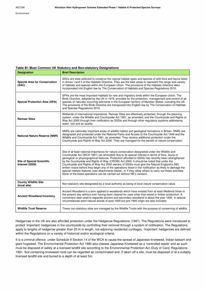
AECOM Woolston Weir Hydropower Scheme Extended Phase 1 Habitat & Protected Species Surveys
Environment
Table B1 Most Common UK Statutory and Non-statutory Designations
Designation Brief Description
Special Area for Conservation (SAC)
SACs are sites selected to conserve the natural habitat types and species of wild flora and fauna listed in Annex I and II of the Habitats Directive. They are the best areas to represent the range and variety of habitats and species within the European Union. The provisions of the Habitats Directive were incorporated into English law by The Conservation of Habitats and Species Regulations 2010.
Special Protection Area (SPA)
SPAs are the most important habitats for rare and migratory birds within the European Union. The Birds Directive, adopted by the UK in 1979, provides for the protection, management and control of all species of naturally occurring wild birds in the European territory of Member States, including the UK. The provisions of the Birds Directive are transposed into English law by The Conservation of Habitats and Species Regulations 2010.
Ramsar Sites
Wetlands of international importance. Ramsar Sites are effectively protected, through the planning system, under the Wildlife and Countryside Act 1981, as amended, and the Countryside and Rights of Way Act 2000 through their notification as SSSIs and through other regulatory systems addressing water, soil and air quality
National Nature Reserve (NNR)
NNRs are nationally important areas of wildlife habitat and geological formations in Britain. NNRs are designated and protected under the National Parks and Access to the Countryside Act 1949 and the Wildlife and Countryside Act 1981, as amended. They receive additional protection under the Countryside and Rights of Way Act 2000. They are managed for the benefit of nature conservation.
Site of Special Scientific Interest (SSSI)
Site of at least national importance for nature conservation designated under the Wildlife and Countryside Act (WCA 1981) (as amended) due to its special interest in terms of flora, fauna or geological or physiographical features. Protection afforded to SSSIs has recently been strengthened by the Countryside and Rights of Way (CROW) Act 2000. It should be noted that under the Countryside and Rights of Way Act 2000 owners of SSSIs must give the Natural England’s (NE) written notice before they begin any of the operations listed in the notification as likely to damage the special interest features (see attachments below), or if they allow others to carry out these activities. None of the listed operations can be carried out without NE’s consent.
County Wildlife Site (local site)
Non-statutory site designated by a local authority as being of local nature conservation value.
Ancient Woodland Inventory
Ancient Woodland is a term applied to woodlands which have existed from at least Medieval times to the present day without ever having been cleared for uses other than wood or timber production. A convenient date used to separate ancient and secondary woodland is about the year 1600. In special circumstances semi-natural woods of post-1600 but pre-1900 origin are also included.
Wildlife Trust Reserve These non-statutory sites are managed by the Wildlife Trusts with the purpose of conserving of wildlife.
Hedgerows in the UK are also afforded protection under the Hedgerow Regulations (1997). The Regulations were introduced to
protect ‘important’ hedgerows in the countryside by controlling their removal through a system of notification. The Regulations
apply to lengths of hedgerow greater than 20 m in length, not adjoining residential curtilages. ‘Important’ hedgerows are defined
within the Regulations on a variety of historical and/or ecological criteria.
It is a criminal offence, under Schedule 9 Section 14 of the WCA to cause the spread of Japanese knotweed, Indian balsam and
giant hogweed. The Environmental Protection Act 1990 also classes Japanese Knotweed as a ‘controlled waste’ and as such
must be disposed of safely at a licensed landfill site according to the Environmental Protection Act (Duty of Care) Regulations
1991. Soil containing knotweed roots can be regarded as contaminated and, if taken off a site, must be disposed of at a suitably
licensed landfill site and buried to a depth of at least 5m.
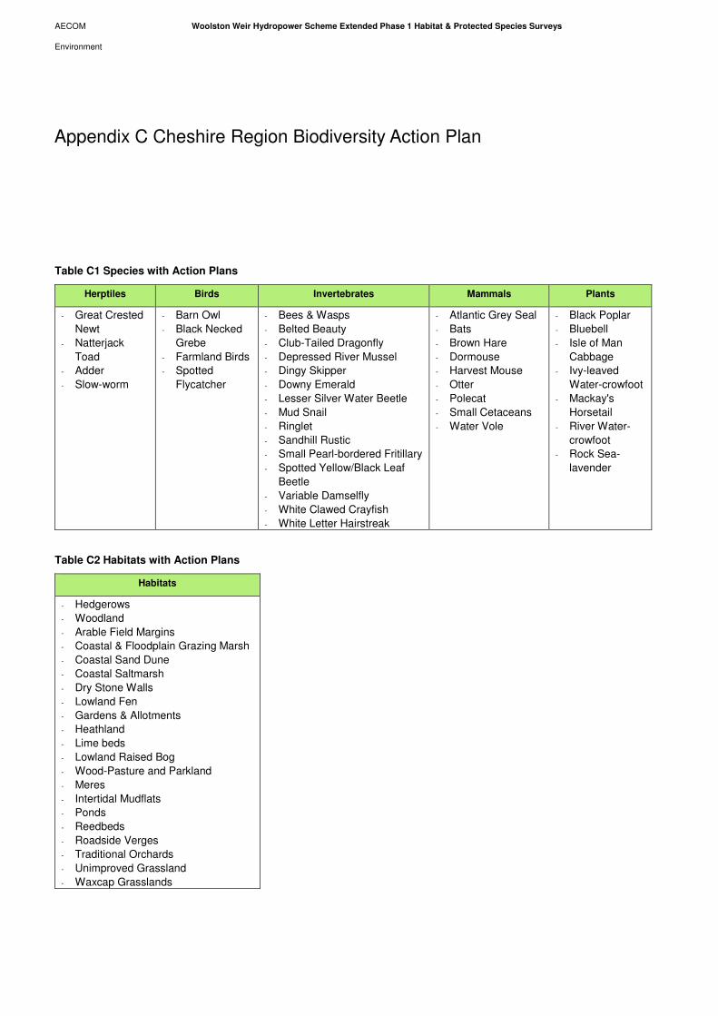
AECOM Woolston Weir Hydropower Scheme Extended Phase 1 Habitat & Protected Species Surveys
Environment
Table C1 Species with Action Plans
Herptiles Birds Invertebrates Mammals Plants
- Great Crested
Newt
- Natterjack
Toad
- Adder
- Slow-worm
- Barn Owl
- Black Necked
Grebe
- Farmland Birds
- Spotted
Flycatcher
- Bees & Wasps
- Belted Beauty
- Club-Tailed Dragonfly
- Depressed River Mussel
- Dingy Skipper
- Downy Emerald
- Lesser Silver Water Beetle
- Mud Snail
- Ringlet
- Sandhill Rustic
- Small Pearl-bordered Fritillary
- Spotted Yellow/Black Leaf
Beetle
- Variable Damselfly
- White Clawed Crayfish
- White Letter Hairstreak
- Atlantic Grey Seal
- Bats
- Brown Hare
- Dormouse
- Harvest Mouse
- Otter
- Polecat
- Small Cetaceans
- Water Vole
- Black Poplar
- Bluebell
- Isle of Man
Cabbage
- Ivy-leaved
Water-crowfoot
- Mackay's
Horsetail
- River Water-
crowfoot
- Rock Sea-
lavender
Table C2 Habitats with Action Plans
Habitats
- Hedgerows
- Woodland
- Arable Field Margins
- Coastal & Floodplain Grazing Marsh
- Coastal Sand Dune
- Coastal Saltmarsh
- Dry Stone Walls
- Lowland Fen
- Gardens & Allotments
- Heathland
- Lime beds
- Lowland Raised Bog
- Wood-Pasture and Parkland
- Meres
- Intertidal Mudflats
- Ponds
- Reedbeds
- Roadside Verges
- Traditional Orchards
- Unimproved Grassland
- Waxcap Grasslands
Appendix C Cheshire Region Biodiversity Action Plan

AECOM Woolston Weir Hydropower Scheme Extended Phase 1 Habitat & Protected Species Surveys
Environment
Table D1 Woolston Weir Extended Phase 1 Habitat Map (Figure 2) Target Notes
Target Note Number (TN) Description
TN1 Swamp habitat – potential for GCN and water vole
TN2 Extent of rock armour
TN3 Mammal track
TN4 Badger latrines
TN5 Giant hogweed
TN 6 Mature and semi-mature trees
TN 7 Possible Himalayan balsam (anecdotal evidence)
TN 8 Willow Carr
Appendix D Target Notes

AECOM Woolston Weir Hydropower Scheme Extended Phase 1 Habitat & Protected Species Surveys
Environment
Appendix E Woolston Eyes SSSI Citation
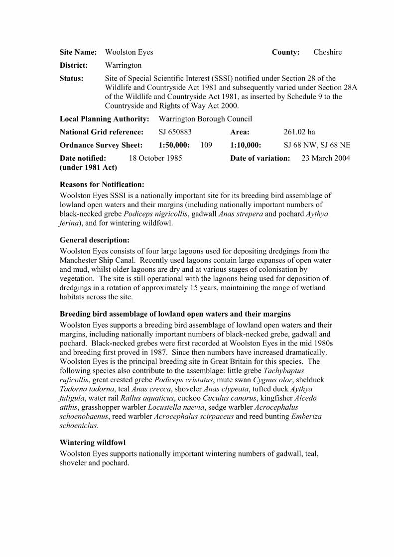
Site Name: Woolston Eyes County: Cheshire
District: Warrington
Status:
Site of Special Scientific Interest (SSSI) notified under Section 28 of the Wildlife and Countryside Act 1981 and subsequently varied under Section 28A of the Wildlife and Countryside Act 1981, as inserted by Schedule 9 to the Countryside and Rights of Way Act 2000.
Local Planning Authority: Warrington Borough Council
National Grid reference: SJ 650883 Area: 261.02 ha
Ordnance Survey Sheet: 1:50,000: 109 1:10,000: SJ 68 NW, SJ 68 NE
Date notified: (under 1981 Act)
18 October 1985 Date of variation: 23 March 2004
Reasons for Notification: Woolston Eyes SSSI is a nationally important site for its breeding bird assemblage of lowland open waters and their margins (including nationally important numbers of black-necked grebe Podiceps nigricollis, gadwall Anas strepera and pochard Aythya ferina), and for wintering wildfowl.
General description: Woolston Eyes consists of four large lagoons used for depositing dredgings from the Manchester Ship Canal. Recently used lagoons contain large expanses of open water and mud, whilst older lagoons are dry and at various stages of colonisation by vegetation. The site is still operational with the lagoons being used for deposition of dredgings in a rotation of approximately 15 years, maintaining the range of wetland habitats across the site.
Breeding bird assemblage of lowland open waters and their margins Woolston Eyes supports a breeding bird assemblage of lowland open waters and their margins, including nationally important numbers of black-necked grebe, gadwall and pochard. Black-necked grebes were first recorded at Woolston Eyes in the mid 1980s and breeding first proved in 1987. Since then numbers have increased dramatically. Woolston Eyes is the principal breeding site in Great Britain for this species. The following species also contribute to the assemblage: little grebe Tachybaptus ruficollis, great crested grebe Podiceps cristatus, mute swan Cygnus olor, shelduck Tadorna tadorna, teal Anas crecca, shoveler Anas clypeata, tufted duck Aythya fuligula, water rail Rallus aquaticus, cuckoo Cuculus canorus, kingfisher Alcedo atthis, grasshopper warbler Locustella naevia, sedge warbler Acrocephalus schoenobaenus, reed warbler Acrocephalus scirpaceus and reed bunting Emberiza schoeniclus.
Wintering wildfowl Woolston Eyes supports nationally important wintering numbers of gadwall, teal, shoveler and pochard.

In addition to the reasons for notification, the site also hosts a notable assemblage of amphibians including common frog Rana temporia, common toad Bufo bufo, great crested newt Triturus cristatus and smooth newt Triturus vulgaris. Wintering tufted duck use Woolston Eyes in numbers of regional importance.
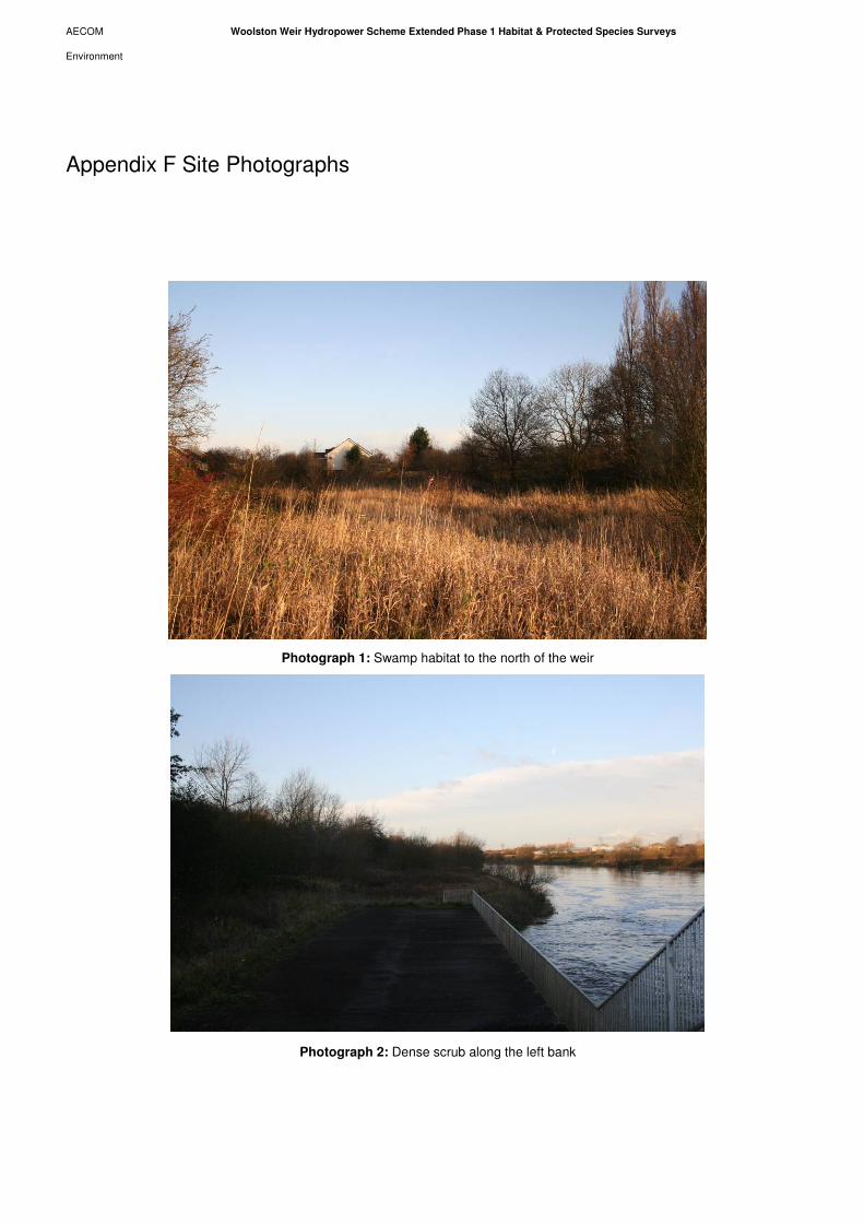
AECOM Woolston Weir Hydropower Scheme Extended Phase 1 Habitat & Protected Species Surveys
Environment
Photograph 1: Swamp habitat to the north of the weir
Photograph 2: Dense scrub along the left bank
Appendix F Site Photographs
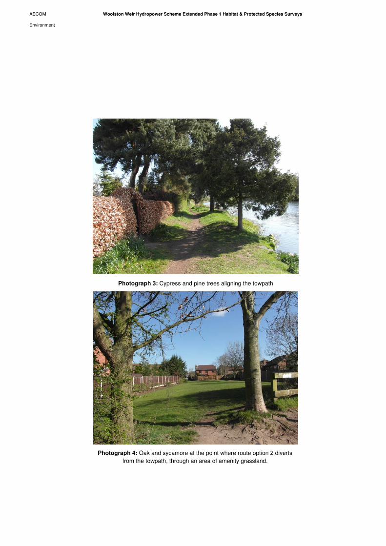
AECOM Woolston Weir Hydropower Scheme Extended Phase 1 Habitat & Protected Species Surveys
Environment
Photograph 3: Cypress and pine trees aligning the towpath
Photograph 4: Oak and sycamore at the point where route option 2 diverts
from the towpath, through an area of amenity grassland.
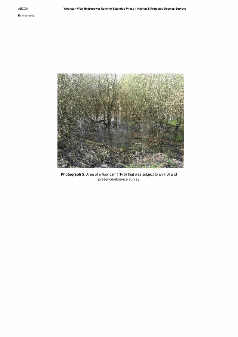
AECOM Woolston Weir Hydropower Scheme Extended Phase 1 Habitat & Protected Species Surveys
Environment
Photograph 5: Area of willow carr (TN 8) that was subject to an HSI and
presence/absence survey

AECOM Woolston Weir Hydropower Scheme Extended Phase 1 Habitat & Protected Species Surveys
Environment
Appendix G Woolston Weir Breeding Bird Survey Interim Technical Note.
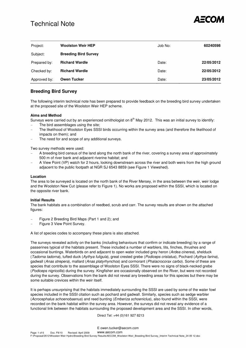
Technical Note
Direct Tel: +44 (0)161 927 8213
www.aecom.com
Page: 1 of 6 Doc. F8/10 Revised: April 2009
F:\Proposal\3512\Woosten Weir Hydro\Breeding Bird Survey Results\AECOM_Woolston Weir_Breeding Bird Survey_Interim Technical Note_24 05 12.doc
Project: Woolston Weir HEP Job No: 60240598
Subject: Breeding Bird Survey
Prepared by: Richard Wardle Date: 22/05/2012
Checked by: Richard Wardle Date: 22/05/2012
Approved by: Owen Tucker Date: 23/05/2012
Breeding Bird Survey
The following interim technical note has been prepared to provide feedback on the breeding bird survey undertaken
at the proposed site of the Woolston Weir HEP scheme.
Aims and Method
Surveys were carried out by an experienced ornithologist on 8th
May 2012. This was an initial survey to identify:
- The bird assemblages using the site;
- The likelihood of Woolston Eyes SSSI birds occurring within the survey area (and therefore the likelihood of
impacts on them); and
- The need for and scope of any additional surveys.
Two survey methods were used:
- A breeding bird census of the land along the north bank of the river, covering a survey area of approximately
500 m of river bank and adjacent riverine habitat; and
- A View Point (VP) watch for 2 hours, looking downstream across the river and both weirs from the high ground
adjacent to the public footpath at NGR SJ 6543 8859 (see Figure 1 Viewshed).
Location
The area to be surveyed is located on the north bank of the River Mersey, in the area between the weir, weir lodge
and the Woolston New Cut (please refer to Figure 1). No works are proposed within the SSSI, which is located on
the opposite river bank.
Initial Results
The bank habitats are a combination of reedbed, scrub and carr. The survey results are shown on the attached
figures:
- Figure 2 Breeding Bird Maps (Part 1 and 2); and
- Figure 3 View Point Survey.
A list of species codes to accompany these plans is also attached.
The surveys revealed activity on the banks (including behaviours that confirm or indicate breeding) by a range of
passerines typical of the habitats present. These included a number of warblers, tits, finches, thrushes and
occasional buntings. Waterbirds on and adjacent to open water included grey heron (Ardea cinerea), shelduck
(Tadorna tadorna), tufted duck (Aythya fuligula), great crested grebe (Podiceps cristatus), Pochard (Aythya farina),
gadwall (Anas strepera), mallard (Anas platyrhynchos) and cormorant (Phalacrocorax carbo). Some of these are
species that contribute to the assemblage of Woolston Eyes SSSI. There were no signs of black-necked grebe
(Podiceps nigricollis) during the survey. Kingfisher are occasionally observed on the River, but were not recorded
during the survey. Observations from the bank did not reveal any breeding areas for this species but there may be
some suitable crevices within the weir itself.
It is perhaps unsurprising that the habitats immediately surrounding the SSSI are used by some of the water fowl
species included in the SSSI citation such as pochard and gadwall. Similarly, species such as sedge warbler
(Acrocephalus schoenobaenus) and reed bunting (Emberiza schoeniclus), also found within the SSSI, were
recorded on the bank habitat within the survey area. However, the surveys did not reveal any evidence of a
functional link between the habitats surrounding the proposed development area and the SSSI. In other words,

Technical Note
based on the habitats present and the results of the initial bird survey, there is no reason to believe that the
construction or operation of the proposed turbine would have any impact on the habitats or the interest features of
Woolston Eyes SSSI.
It is considered highly unlikely that there will be any operational effects of the proposed development on birds,
particularly when considered against the baseline conditions of an operational weir, and we consider at this point
that there is no need for further baseline surveys. However, there still exists the potential for construction and the
site clearance preceding it to have an adverse impact on breeding bird through habitat loss and damage to nests. It
is therefore suggested that a combination of some or all of the following conditions are included within the scheme:
• Clearance of vegetation outside of the bird breeding season (i.e. not between March and July inclusive);
• Re-planting of vegetation post construction to mitigate habitat loss according to a planting scheme to be agreed in advance of works; and
• Checks of vegetation for nesting birds immediately prior to clearance and standoffs around nests imposed to protect them from construction damage until young have fledged.
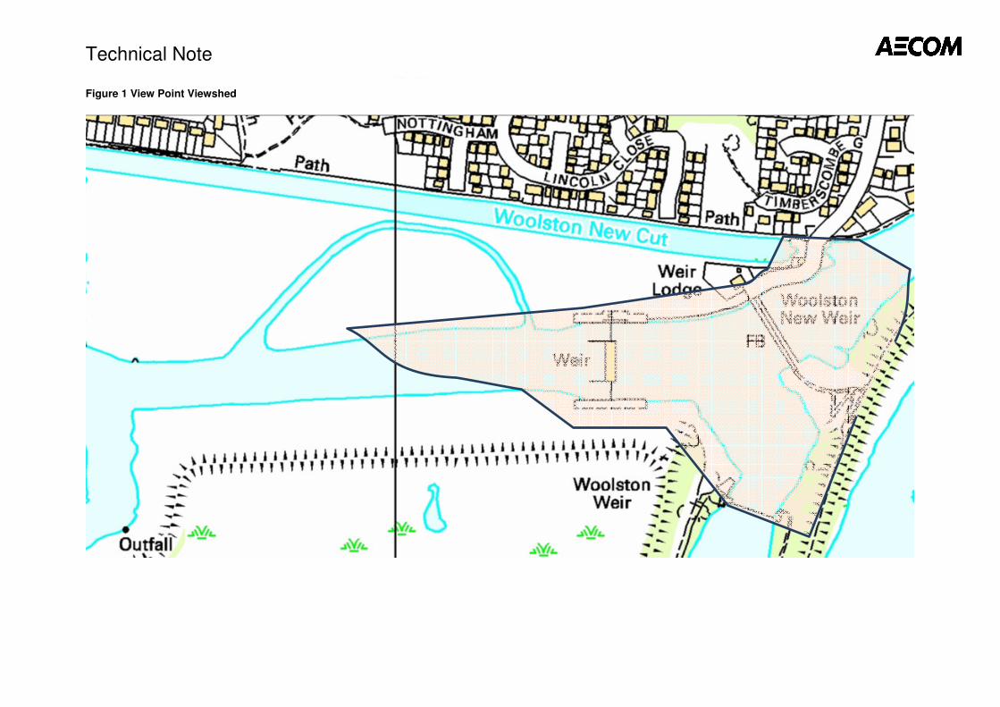
Technical Note
Figure 1 View Point Viewshed
Liverpoolemail
New Stamp
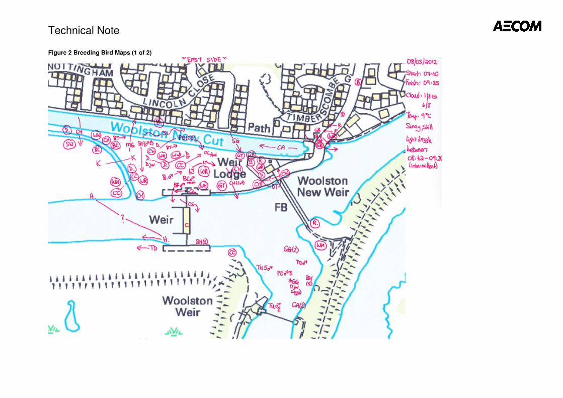
Technical Note
Figure 2 Breeding Bird Maps (1 of 2)
Liverpoolemail
New Stamp
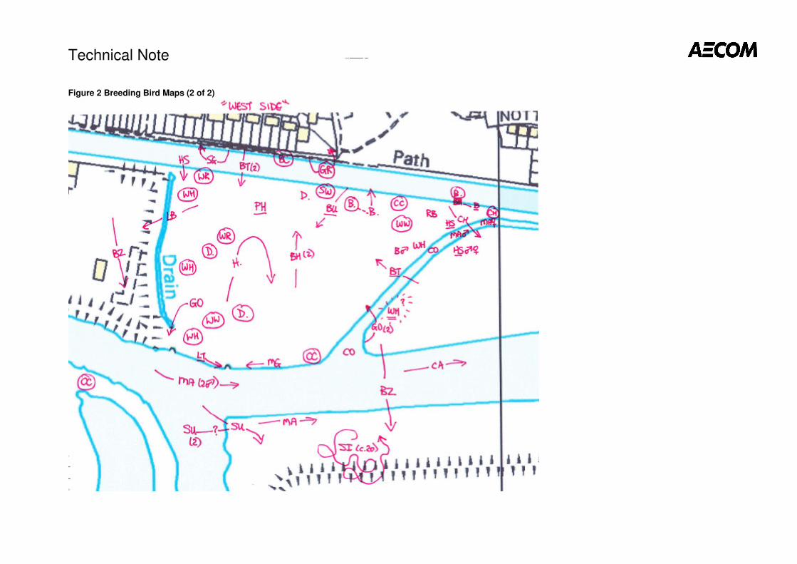
Technical Note
Figure 2 Breeding Bird Maps (2 of 2)
Liverpoolemail
New Stamp
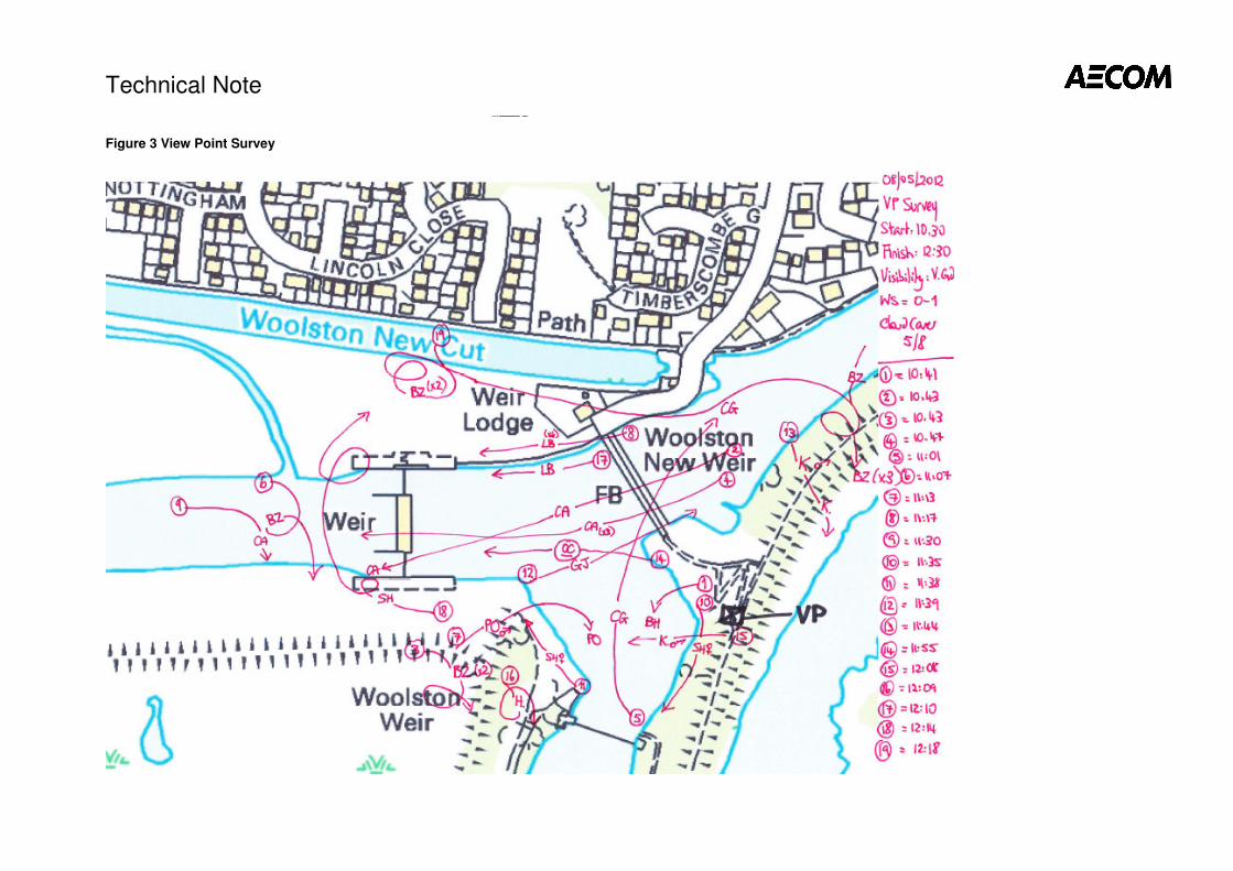
Technical Note
Figure 3 View Point Survey
Liverpoolemail
New Stamp