Fire Effects Planning Framework PROPOSED Agenda Working session Richfield, UT 12/7-8/06 -Overview...
19
Fire Effects Planning Framework PROPOSED Agenda Working session Richfield, UT 12/7-8/06 -Overview and orientation (powerpoint presentation) - Gather/process/analyze data (working meeting) - fire behavior - fire effects - crosswalk creation - Create Map Library (subsequent task by individual forest)
-
date post
22-Dec-2015 -
Category
Documents
-
view
214 -
download
0
Transcript of Fire Effects Planning Framework PROPOSED Agenda Working session Richfield, UT 12/7-8/06 -Overview...

Fire Effects Planning FrameworkPROPOSED Agenda
Working sessionRichfield, UT 12/7-8/06
-Overview and orientation (powerpoint presentation)
- Gather/process/analyze data (working meeting)- fire behavior- fire effects- crosswalk creation
- Create Map Library (subsequent task by individual forest)

Extreme – 99%
High – 90%
Moderate – 80%
SpeciesSize/
StructureCrown fire potential
1st OrderFire Effects
Effect onwhitebark pine
Mapping Multiplier
Information Source
WB-only
Seed/sap 1, 2, or 3 HighUndesirable EffectsWB established but not reproducing yet
-1Tomback et al.
2001, FOFEM
All except seed/sap
1,2, or 3 HighDesirable Effectsrestore native fire
regime+1000
Tomback et al. 2001,
FOFEM
All other species mixes
All
2 or 3 HighHighly Desirable Effects provide
potential WB habitat+100
Keane, Arno
Pers. Comm.
1 Low or moderate
Desirable Effects +1Keane, Arno pers.
Com.
No Burn All None NoneNot Habitat
rock above 6500’-100 N/A
Fire Effects Planning Framework (FEPF)Fire Effects Planning Framework (FEPF)
Crosswalkfire behavior to fire effects on
values/objectives
3
Photograph by Steve Sutherland; 2 years post-fire
Extreme – 99%
High – 90%
Moderate – 80%
BITTERROOT NATIONAL FOREST
Fire Effects Planning Framework
2004 Fire Effects Map Library
• Fire Behavior
• Effects on Whitebark pine
• Effects on Lynx foraging habitat
Extreme – 99%
High – 90%
Moderate – 80%
Fire EffectsFire
BehaviorVegetative attributes Desirability
LandscapeDynamics
Simulation Models
Identify resources of interest
Identify associated vegetative attributes
Identify fire ecology
1
FlamMap 99th%
90th%
80th%
Based on FireFamilyPlus weather analysis for Energy Release Component
Modelfire behavior
2
Updatevegetative attributes
post-season
5
Create map library for - land, fuels, fire planning,
- AMR/WFU activities
4
Source
Fire Effects Planning
Framework
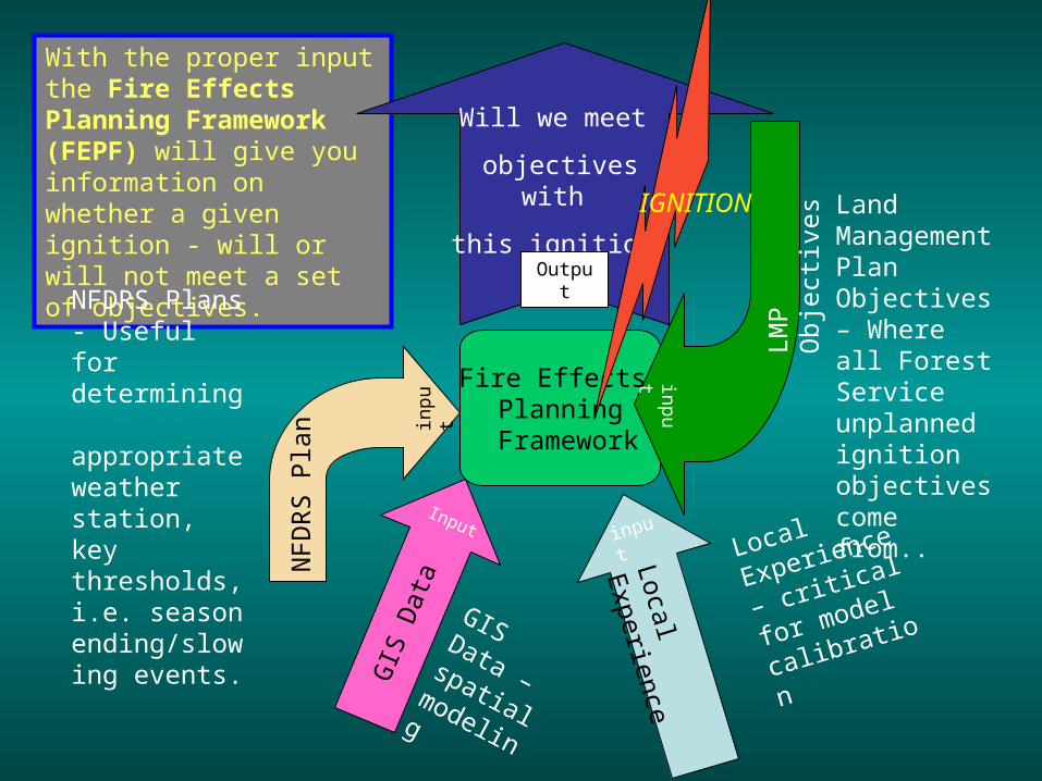
With the proper input the Fire Effects Planning Framework (FEPF) will give you information on whether a given ignition - will or will not meet a set of objectives.
NFDRS Plans - Useful for determining appropriate weather station, key thresholds, i.e. season ending/slowing events.
NF
DR
S P
lan in
put
Land Management Plan Objectives – Where all Forest Service unplanned ignition objectives come from..
LMP
Obj
ectiv
es
input
Local
Experience –
critical for
model
calibration
Local Experience
input
Will we meet
objectives with
this ignition?
Output
IGNITION
GIS Data – spatial
modeling
Input
GIS
Dat
a
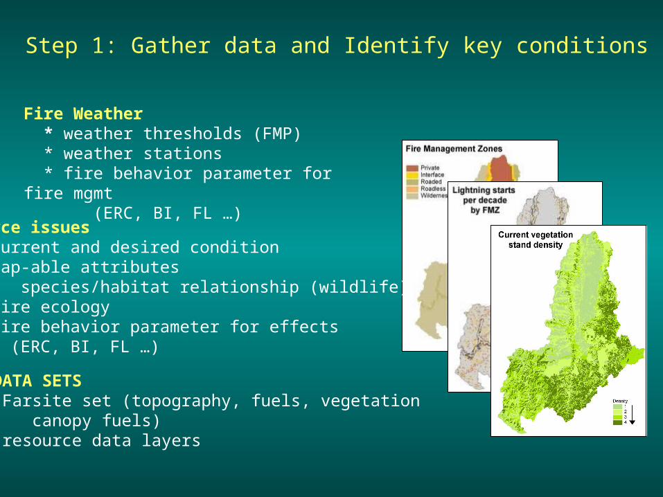
Step 1: Gather data and Identify key conditions
Fire Weather * weather thresholds (FMP) * weather stations * fire behavior parameter for fire mgmt (ERC, BI, FL …)
Resource issues * current and desired condition * map-able attributes species/habitat relationship (wildlife) * fire ecology * fire behavior parameter for effects (ERC, BI, FL …)
GIS DATA SETS * Farsite set (topography, fuels, vegetation canopy fuels) * resource data layers

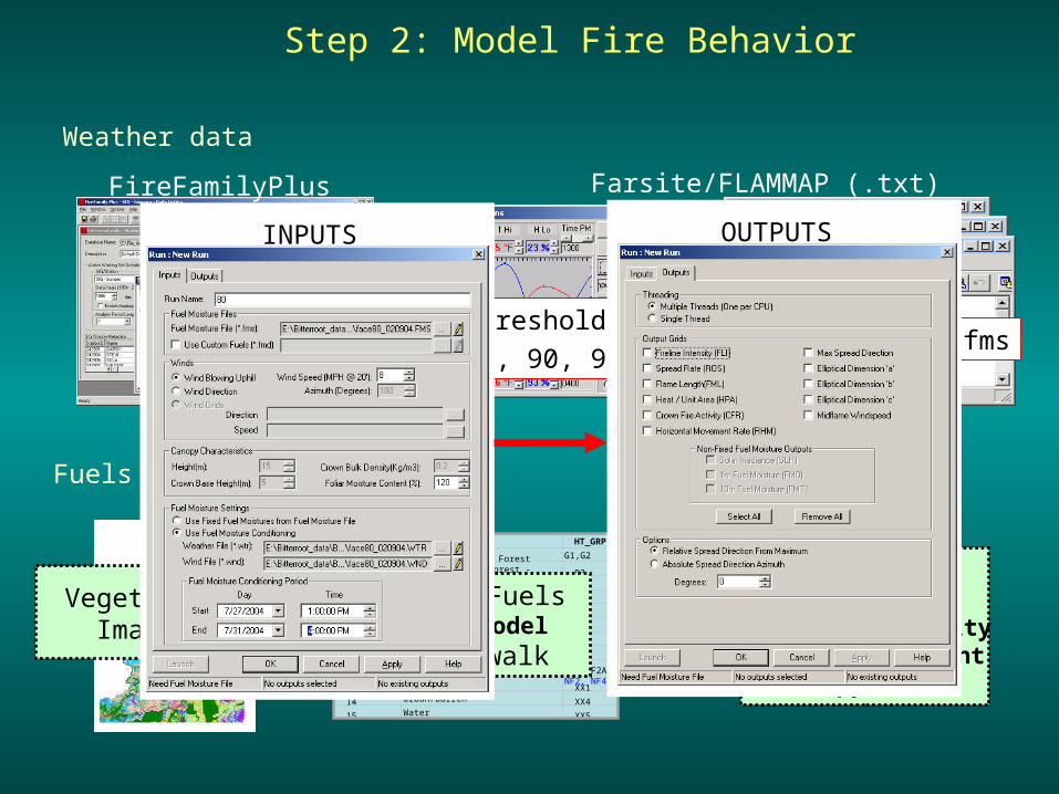
Weather data
FireFamilyPlus Farsite/FLAMMAP (.txt)
Seasonal %’sThreshold %’s80, 90, 99th%
.wnd, .wtr, .fms
Step 2: Model Fire Behavior
Fuels data (LANDFIRE)
Fuel ModelStand Height
Crown Bulk DensityCrown Base Height
Canopy Cover
PVTGROUP PVT GROUP NAME HT_GRP
1 Upper Subalpine Forest G1,G2
2 Lower Subalpine Forest - Mesic D3, E2
3 Lower Subalpine Forest - Xeric F1, F2
4 Upper Montane Forest - Mesic C2, D2
5 Upper Montane Forest - Xeric C1
6 Lower Montane Forest - Mesic B2, B3
7 Lower Montane Forest - Xeric A2, B1
8 Upper Subalpine Shrub - Herbaceous NF5
11 Lower Montane Shrub - Herbaceous NF1,NF2A, NF2, NF4
13 Agricultural XX1
14 Urban/Barren XX4
15 Water XX5
Vegetation/Imagery
Canopy Fuels Fuel ModelCrosswalk
INPUTS OUTPUTS

Species/ Species Mix
Size/ Structure
Fire Sever
ity
0-14years
post-fire
15-39 years post-fire
40+years
post-fire
WB, DF, L, PP, LP, L-mixes, DF-mixes, PP-mixes
Single story Low -1 -1 -1
Single story Mixed 1 1 -10
Single or multi-story
High -1 10 10
Mixtures of DF, ES,AF, WB, LP, AL, L, GF
Single story Low -1 -1 -1
Single story Mixed 1 1 -10
Single or multi-story
High -1 10 10
ES, GF,AL, C, QA, WH, MH, AF, CW
Single story Mixed 1 1 -10
Single or multi-story
High -1 10 10
All forested Seed/sap High -1 10 10
Shrubs All Mixed or High
-10 1 1
No Burn 1 -10 -10
Non-stocked, non-forest, forbs, grasses
All Low, Mixed,
No Burn
-1 -1 -1
Unburnable, Agriculture, No Data
n/a All 0 0 0
1
2
3
1
2
3
2
3
3
2 or 3
0
0,1, or 2
0,1,2,or 3
FireBehavior
Ecological Fire Behavior
Fire effects on targetover time
Step 3: Merge to create Fire Effects Crosswalks
Physical habitat characteristics
Physical Fire Behavior
Illustrative only
Stored as set of rulesor as .txt file
FOFEMFVS-FFESIMPPLLEWHRMURMPublicationsExpert Systems

FlamMap
Crown Fire PotentialRate of SpreadFireline Intensity
Step 4a: Create Fire Behavior Library
99th%
90th%
80th%

Fire BehaviorLibrary
Step 4b: Create Fire Effects Library
Restoration/Fuels Lynx
99th%90th%80th%
Aquatics
Fire FighterSafety
Cavity Nester

Initial vegetation
Lynx habitat
Fire effectson
vegetation
Fire effectson
Lynx habitat


Fire EffectsLibrary
99th%90th%80th%
Uses: Set fuel treatment priorities

Uses: Model alternatives and future consequences
This example shows use of SIMPPLLE
FVS-FFE can also be used.

Incident Support
Maps are draft, and illustrative only
Uses: Go/NoGo(WFIP analyses)
cost containment
Quantify benefits or reductions in risk within
MMA
Consider potential benefits when determining
suppression strategy by flank
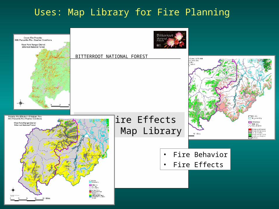
Uses: Map Library for Fire Planning
BITTERROOT NATIONAL FOREST
2004 Fire Effects Map Library
• Fire Behavior• Fire Effects
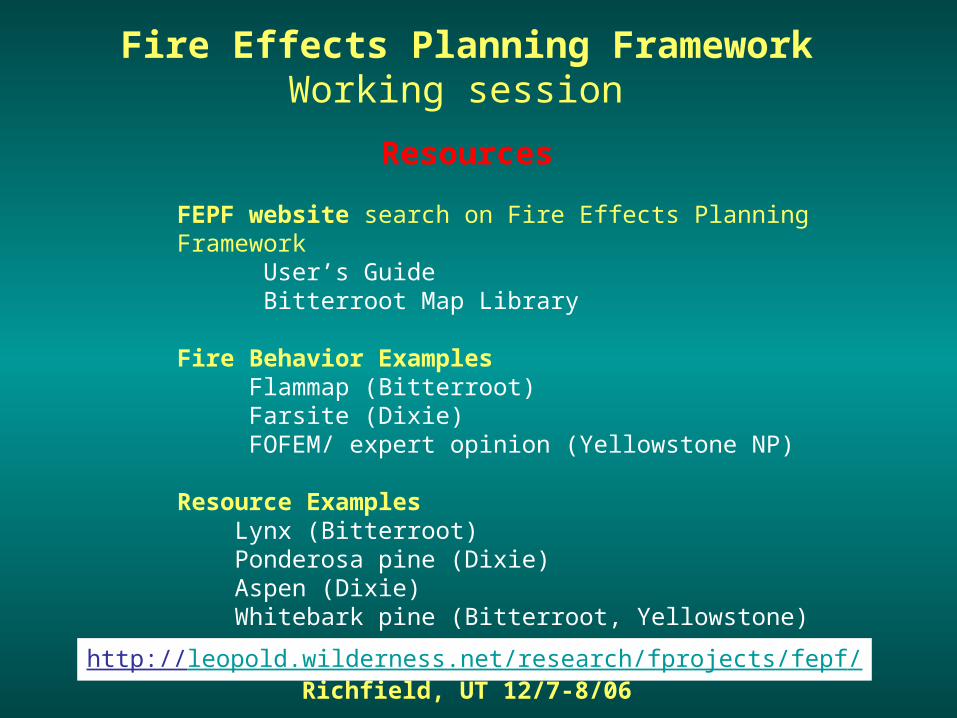
Fire Effects Planning FrameworkWorking session
Richfield, UT 12/7-8/06
FEPF website search on Fire Effects Planning Framework User’s Guide Bitterroot Map Library
Fire Behavior Examples Flammap (Bitterroot) Farsite (Dixie) FOFEM/ expert opinion (Yellowstone NP)
Resource Examples Lynx (Bitterroot) Ponderosa pine (Dixie) Aspen (Dixie) Whitebark pine (Bitterroot, Yellowstone)
Resources
http://leopold.wilderness.net/research/fprojects/fepf/
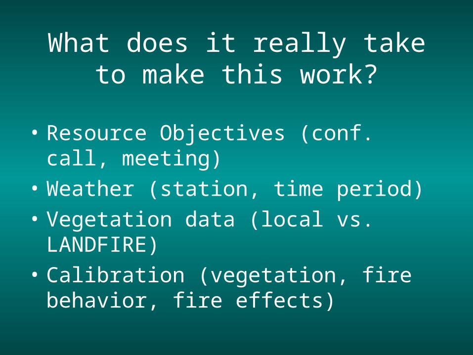
What does it really take to make this work?
• Resource Objectives (conf. call, meeting)
• Weather (station, time period)
• Vegetation data (local vs. LANDFIRE)
• Calibration (vegetation, fire behavior, fire effects)