RTWP COMPREHENSIVE LAND USE PLAN ... - richfield...
42
Richfield Township Comprehensive Land Use Plan Approved 12/01/11
Transcript of RTWP COMPREHENSIVE LAND USE PLAN ... - richfield...

Richfield Township
Comprehensive
Land Use Plan
Approved 12/01/11

2
Richfield Township, Ohio – 2025
Comprehensive Land Use Plan

3
Richfield Township, Ohio – 2025
Comprehensive Land Use Plan
Board of Township Trustees
Laurie Peters Gilmore
David Wyatt
Janet Jankura
Township Zoning Commission
Kurt Kocias
Jerry Ryba
Arlene Pepera
Douglas Mory
John Paulett
Patti Dorsett
Annie Demko

4
Richfield Township Comprehensive Land Use Plan
Table of Contents
Chapter Page
1. Introduction 5
2. History 8
3. Cultural/Historic Resource Preservation 10
4. Demographics 13
5. Housing 17
6. Land Use 23
7. Natural Resources 29
8. Utilities & Storm Water Management 34
9. Economic Development 36
10. Transportation 39
11. Implementation & Policy 41
12. Conclusions 42

5
Chapter 1: Introduction
Richfield Township 2025
Planning for the Future
The Comprehensive Land Use Plan Defined
The Richfield Township Comprehensive Land Use Plan (the Plan) is an official document which
sets forth major goals concerning physical development and use of land within the Township to
the year 2025. It shows the relationships among different types of land use, taking into account
the physical characteristics of the land and considers the potential for development and forecasts
population change.
The Plan is a guide – not a blueprint, and as such must be reviewed and adjusted as conditions
change. It is intended this Plan guides those responsible for determining public planning policy
in the future.
An objective of the Township Plan is to support the greater goals of the Summit County General
Land Use Development Plan (SC Plan) and the intention of this document is to examine
characteristics of Richfield Township that may be in close alignment with the goals of that Plan,
while pointing out characteristics of the Township that may not support certain SC Plan
elements.
Location
Richfield Township is located in the northwest corner of Summit County and is bounded on the
west by Medina County and the north by Cuyahoga County. Adjacent communities include Bath
& Boston Townships (Summit County), Hinckley Township (Medina County, to the west), the
Village of Richfield (Summit), which bisects Richfield Township and the Cities of Brecksville
and Broadview Heights (Cuyahoga County, to the north). Summit County is named for the
highest point along the Ohio-Erie Canal and Richfield has the geographic distinction of being the
highest elevation point in Summit County.
Vision Statement
The development of this Plan is being done, in part, so that Richfield Township may continue to
be a peaceful top-rated primarily residential community incorporating limited mixed use zoning
with a high quality of life in a rural setting with modern conveniences.
The 200th
anniversary of Richfield Township was observed in 2009 and this planning effort
focuses on the next fifteen years from 2011 through 2025. Questions to be addressed by this
Plan include the following: How should the undeveloped land within the township be used?
What are the desires of the Township regarding land use, especially regarding density and non-
residential uses? What are the qualities most important to be nurtured and maintained? How
many residents and businesses are expected to be in the Township in the next fifteen years?
This Comprehensive Land Use Plan for Richfield Township attempts to answer these questions
and others as the Township considers problems and opportunities and formulates the following
land use planning goals:

6
Goals
Preserve the Rural Character of the Township by promoting establishment of small
farms, monitoring present residential densities, without increasing net density and
considering other areas for conservation district zoning.
Maintain and Preserve Open Space by encouraging conservation development that allows
for preservation of environmentally sensitive areas and promoting trails and bikeways
that connect to regional parks.
Promote Non-Residential Development by encouraging development of the existing
Light Industrial-Office District.
The Planning Process
This Plan was instituted through the processes outlined in Ohio Revised Code (ORC) 519.12.
Although development of a Land Use or Comprehensive Plan is not equivalent to an Amendment
to the Zoning Resolution, it was felt that adherence to the these procedures provided the most
solid and consistent approach to formulation of a Plan that best serves Township interests. As
such, the Plan was initiated by the Township Trustees, developed by the Township Zoning
Commission, reviewed by the Summit County Planning Commission and adopted by the
Township Trustees, all in compliance with the notice, public hearing and other requirements of
ORC 519.12. To encourage public input, all discussion of the Plan was conducted in open
meetings, with notice and advertising, and as the plan neared final development, it was placed on
the Township website for a period of two months before final approval
The process of Plan development began in the mid 2000’s, as the Township Zoning Commission
discussed the need for a comprehensive plan and reviewed plans for other local communities to
determine a preferred format for the Township Plan. In 2008, Planning Consultant Kenneth
Crandall, AICP, was hired to work with the Zoning Commission on development of a
Comprehensive Plan. In the next three-year period, Zoning Commission members and
alternates, including Kurt Kocias, Jerry Ryba, Claudia Gindraw, Arlene Pepera, Douglas Mory,
Dennis Skoda, John Myer, John Paulett, Bill Wendling, Patti Dorsett and Annie Demko worked
with the Planning Consultant on development of the Plan, which was reviewed by the Summit
County Planning Commission on January 27, 2011 and a recommendation to approve the draft
Plan was made by the Commission in May, 2011. The Trustees opened a public hearing for
discussion of the Plan in July, 2011 and revised the plan over the next four-month period. A
joint public meeting was held between the Trustees, Zoning Commission and Board of Zoning
Appeals in November, 2011 and the plan was approved for adoption on December 1, 2011 by
vote of the Trustees.

7
The Township has identified several issues facing the Township:
• Certain areas of the Township with unique physical characteristics may
warrant low density residential conservation type development.
• The rural residential character of the Township should be maintained.
• The possibility of increasing Township revenues through development of
commercial/industrial uses should be investigated, if it is possible to achieve
without negatively impacting the residential/agricultural feel of the Township.
• It is important to encourage preservation of existing agricultural uses and
development of additional agricultural uses.
• The large amount of existing park land should be capitalized on as a benefit to
the Township.
• Urban sprawl should be discouraged by cautiously reviewing proposals for
increased densities in residential development.
• Possible actions to discourage annexation should be investigated.

8
Chapter 2: History
Richfield Township – History and Relationship to the Region
The township was founded in 1809 and originally was 25 square miles in size. Since that time,
the number of acres lost to annexation and separation totals 5536. In 1967, the Village of
Richfield was formed and incorporated, adopting a Charter, which allows for the voting of a
Mayor and seven council members.
In addition to land area lost through several annexations to the Village of Richfield, the
Township separated from the Village of Richfield in 2003, leaving the Township with its current
area of 16.35 square miles. The separation action was initiated in early 1998, with a submission
to Summit County Council of a petition signed by Township property owners requesting the
erection of a new township excluding territory of the incorporated Village of Richfield. The
petition was filed under the requirements of Ohio Revised Code Sections 503.09 through 503.12
and was signed by more than four hundred township landowners. Township records state that the
reason for the separation action was the failure of Village of Richfield voters to pass a general
fund operating levy when it was on the ballot twice in the last three elections. Subsequent to the
filing of the separation petition, Summit County Council allowed the request of 119 residents to
have their names removed from the petition, bringing it below the minimum 360 signatures
required for approval. In 2000, the Summit County Court of Common Pleas ruled the signature
removal as an improper procedure and ordered the Summit County Council to take immediate
action to form a new township excluding the village.
The action ordering erection of a new township was taken on August 12, 2003, with Summit
County Council Resolution #2003-429. The Summit County Council approved the agreed
apportionment of the existing Township’s indebtedness to the Village, with the following
distribution of assets:
Ownership transferred to the Village of Richfield:
Property
Description
Value-Land and
Buildings
Triangle Park $5,010
Fellowship Hall $82,030
Old Town Hall $153,250
Streetsboro Road (7
acres)
$283,330
Richfield Park (21
and 303)
$29,500
Richfield Town
Hall Building
$250,000
Total Assets
Transferred
$803,120

9
Ownership retained by Richfield Township:
Cash on Hand Approximately $352,128
Tools & Equipment $28,713
Real Property
Rising Valley Park $743,900
3038 Boston Mills Road $82,610
Total Assets Retained $1,207,351
Since the first settler arrived, the Township has evolved to become home to a population of 2517,
as shown in the table below.
Exhibit 1: Population of Richfield Township 1980-2010
Year 1980 1990 2000 2010
Population 1504 1893 2138 2517
% Change -12.3% +25.9% +12.9% +17.7
The City of Cleveland to the north and City of Akron to the south have had an impact on the
Township. The location of the Ohio Turnpike (I-80) and I-77 and I-271 have provided
opportunities for commercial and industrial growth in the general area and high-value residential
development in the Township.
Several parks systems own acreage within the township, including the Cuyahoga Valley National
Park, with 1461 acres, Metro Parks Serving Summit County, with 637 acres and the Cleveland
Metroparks, with 134 acres. The forty-three acres that constitutes Rising Valley Park is owned
and maintained by the Township.
While the Township enjoys an excellent location between two major cities and access to three
interstate highways, the steep topography and lack of utilities, i.e., sewer and water, have
allowed the Township to maintain a low density, rural character. A typical lot size in new
developments is four or more acres.

10
Chapter 3: Cultural/Historic Resource Preservation
In terms of cultural and historic resource protection, the SC Plan addresses issue such as
community character and identity, smart growth and preservation and historic and modern
cultural resources. Richfield Township shares many desirable qualities of other Summit County
communities surveyed for the SC Plan, such as “sense of community” “small town atmosphere”
and “community atmosphere”.
Many acres of land within the Township have been preserved through park acquisition and
public and private preservation easements. As supported by the SC Plan, the Township has
participated since the 1990’s in smart growth residential development, approving zoning for the
Deer Creek subdivision, which has since annexed to the Village of Richfield and the Glencairn
Forest subdivision. Historic and modern cultural resources are not a significant feature of the
Township landscape. The SC Plan notes the Township has one property on the National Register
of Historic Places, which is the James Kirby Mill, located on the site of the current Great Trail
Girl Scout Camp property, near S.R. 303 and Oviatt Roads. Additionally, there are six Ohio
Archeological Inventory Sites and nine Ohio Historic Inventory Sites, most of which are
unidentified by name. This is a lower number of significant historic places than most Summit
County communities. Part of this is due to the fact that the Township is completely bisected
north to south by the Village of Richfield, as result of the 2003 separation action. The “center of
town” located within the Village contains the majority of historical sites in Richfield. Exhibits 2
and 3 show the historic places for Richfield Township and for the county as a whole.
While Township residents are supporters of many area modern cultural resources, there are none
to speak of actually located within the Township. Resources named by the SC Plan include the
Blossom Music Center, National Inventors Hall of Fame, Akron Art Museum, Akron Civic
Theatre, Akron Arts Alliance and Lock 3. These and most other modern cultural resources are
located within larger municipal communities.

11
Page left blank – insert pdf – Exhibit 2 historic places and districts, Richfield Township

12
Page left blank – insert pdf – Exhibit 3 historic places and districts, Summit County

13
Chapter 4: Demographics
Population changes 1980-2010
The U.S. Bureau of the Census reported an increase in the Township population of 1013 between
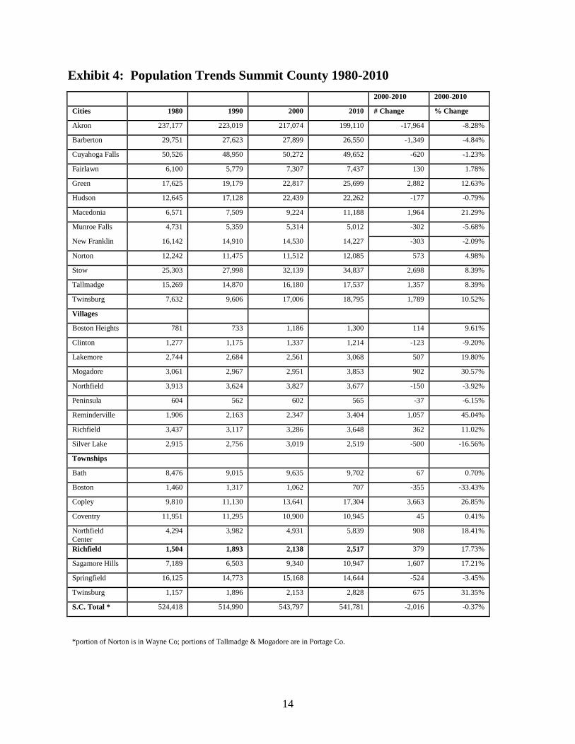
1980 and 2010. Growth of the Township is shown in Exhibit 4.
Since 2000 population of the Township has increased by 379 for a total of 2517 representing an
increase of 17.7 percent. This compares to an increase of 245 or only 12.9 percent from 1990 to
2000.
The Township population increased at a higher rate than most of the jurisdictions close to Akron
but at a much lower rate than the developing areas of the County.
The figures in Exhibit 5 indicate an aging population with the largest increase in the 55 to 79 age
group and a decline in the 20-34 age group. Median age in the Township is approximately 48
years.
14
Exhibit 4: Population Trends Summit County 1980-2010
2000-2010 2000-2010
Cities 1980 1990 2000 2010 # Change % Change
Akron 237,177 223,019 217,074 199,110 -17,964 -8.28%
Barberton 29,751 27,623 27,899 26,550 -1,349 -4.84%
Cuyahoga Falls 50,526 48,950 50,272 49,652 -620 -1.23%
Fairlawn 6,100 5,779 7,307 7,437 130 1.78%
Green 17,625 19,179 22,817 25,699 2,882 12.63%
Hudson 12,645 17,128 22,439 22,262 -177 -0.79%
Macedonia 6,571 7,509 9,224 11,188 1,964 21.29%
Munroe Falls 4,731 5,359 5,314 5,012 -302 -5.68%
New Franklin 16,142 14,910 14,530 14,227 -303 -2.09%
Norton 12,242 11,475 11,512 12,085 573 4.98%
Stow 25,303 27,998 32,139 34,837 2,698 8.39%
Tallmadge 15,269 14,870 16,180 17,537 1,357 8.39%
Twinsburg 7,632 9,606 17,006 18,795 1,789 10.52%
Villages
Boston Heights 781 733 1,186 1,300 114 9.61%
Clinton 1,277 1,175 1,337 1,214 -123 -9.20%
Lakemore 2,744 2,684 2,561 3,068 507 19.80%
Mogadore 3,061 2,967 2,951 3,853 902 30.57%
Northfield 3,913 3,624 3,827 3,677 -150 -3.92%
Peninsula 604 562 602 565 -37 -6.15%
Reminderville 1,906 2,163 2,347 3,404 1,057 45.04%
Richfield 3,437 3,117 3,286 3,648 362 11.02%
Silver Lake 2,915 2,756 3,019 2,519 -500 -16.56%
Townships
Bath 8,476 9,015 9,635 9,702 67 0.70%
Boston 1,460 1,317 1,062 707 -355 -33.43%
Copley 9,810 11,130 13,641 17,304 3,663 26.85%
Coventry 11,951 11,295 10,900 10,945 45 0.41%
Northfield
Center
4,294 3,982 4,931 5,839 908 18.41%
Richfield 1,504 1,893 2,138 2,517 379 17.73%
Sagamore Hills 7,189 6,503 9,340 10,947 1,607 17.21%
Springfield 16,125 14,773 15,168 14,644 -524 -3.45%
Twinsburg 1,157 1,896 2,153 2,828 675 31.35%
S.C. Total * 524,418 514,990 543,797 541,781 -2,016 -0.37%
*portion of Norton is in Wayne Co; portions of Tallmadge & Mogadore are in Portage Co.

15
Exhibit 5: Richfield Township Age Distribution 1990-2010
2000 -
2010
2000 -
2010
Age 1990 2000 2010 # Change % Change
Under 20 439 518 578 60 11.58%
20-34 355 267 227 -40 -14.98%
35-54 399 769 777 8 1.04%
55-79 361 455 768 313 68.79%
80+ 107 139 167 28 20.14%
Totals 1661 2148 2517 369 17.18%
Projected Population 2025
New construction of three dwelling units in 2010 was the lowest in many years, as shown in
Exhibit 6. The number of zoning certificates issued annually for construction of new residences
ranged from 41 to 46 in the years 2003 to 2006. Although more than one half were cluster
homes, there were 78 single-family dwellings constructed in the R-1 and CD zoning districts.
It is doubtful the Township can expect to recover or maintain the 42 average new residences
constructed in the boom years between 2003 and 2006. The number of units will depend upon
the nation’s economy in general and Northeast Ohio’s economy in particular. At this point a high
and low projection is suggested. A range of eight to fifteen units will provide some basis for
projecting population as well as income for the year 2025.
• Population in 2010 is 2,517.
• The population projected for the Township in 2025 ranges from to 2829 to 3102, as shown in
Exhibit 7.
Exhibit 6: Richfield Township Zoning Permits – Cluster and Single-Family
Homes 2003-2010
Number of Zoning Certificates for New Residences Year Cluster Homes Single Family
Homes
Total
2003 18 23 41
2004 24 16 40
2005 22 24 46
2006 26 15 41
2007 12 10 22
2008 0 6 6
2009 0 9 9
2010 0 3 3
Total 102 106 208

16
Exhibit 7: Population Projections to 2025
New
Dwellings/Year
No. Years Total Dwellings Persons/Dwelling Additional
Population
8 15 120 2.6 312
15 15 225 2.6 585

17
Chapter 5: Housing
As shown in Exhibit 8, the number of households in the Township grew from 568 in 1990 to 706
in 2000 – an increase of 138 unit or 24%. Based on the Census data, there were 899 units in the
Township in 2010, which is an increase of 193 units or 27% over Census year 2000 numbers .
Construction in a cluster-phase area of the Glencairn Forest subdivision accounted for
approximately one half of all dwelling units constructed from 2003 to 2010.
Since this cluster area is completed, construction of new homes will be on already platted lots or
in new subdivisions in the R-1 or Conservation Districts and in areas planned for cluster
housing..
Exhibit 8: Occupied Housing Units 1990 – 2010
Year # of Households
1990 568
2000 706
2010 899
Household Value 2000
The Census Bureau reported the median home value of owner occupied units in the Village and
Township combined was $185,700. There were six residences in the Township valued at more
than one million dollars and 84 units in the Township valued at $500,000 to $999,999, as shown
in Exhibit 9.
Exhibit 9: Median Home Values – 2000
Value # of Homes
$50,000-99,999 6
$100,000-$149,999 70
$150,000-$199,999 95
$200,000-$299,999 117
$300,000-$499,999 139
$500,000-$999,999 84
$1,000,000 or more 6 Source: U.S. Bureau of Census
Age of Housing
When the number of housing units constructed since 2000 are included almost 55 percent of the
housing units in the Township are less than 30 years old, as shown in Exhibit 10.

18
Exhibit 10: Dates of Residential Construction
Year # of Homes
1999 to March 2010 73
1990 to 1998 156
1980 to 1989 98
1970 to 1979 96
1960 to 1969 47
1940 to 1959 131
1939 to earlier 68 Source: U.S. Bureau of Census, Richfield Township Zoning
Household Income
Median household income in the Township, as reported by the U.S. Census Bureau indicates a
higher figure than for Summit County. This is shown on Exhibit 11: 1999 Median Household
Income.
Values of Richfield Township residences are compared with other jurisdictions in the map,
Exhibit 12.

19
Exhibit 11 is pdf insert – insert here/see hard copy - 1999 Median Household Income.

20
Exhibit 12 is pdf insert – insert here/see hard copy - Values of Richfield Township residences are
compared with other jurisdictions in the map, Exhibit 12.

21
Capacity Analysis Methodology
In 2005, the Village of Richfield undertook a project to classify all parcels in the Village and
Township according to existing land use and projected capacity analysis. The Township did not
participate in this project, although there was some limited input into existing land use
identification. An outcome of the 2005 Village project was to project capacity for both the
Village and Township, and the results of this analysis are presented in this section of the Land
Use Plan.
The potential for future development was calculated by measuring the vacant land and applying
present zoning requirements. Land that might be considered available for development was
classified into three levels as follows:
• Level 1 – parcels large enough to permit development
with little or no assembly of other parcels. They have
few, if any, environmental constraints.
• Level 2 – parcels that must be combined with other parcels in
order to be developed. They may have more
environmental constraints.
• Level 3 – parcels requiring assembly of many parcels in
order to be developed. They contain many environmental constraints.
The results of the Village analysis indicated that the number of additional dwelling units that
may reasonably be expected over the next 20 to 30 years within Richfield Township is 763 units.
The addition of 763 dwelling units to the 899 existing dwellings is 1,662. Assuming a continued
household size of 2.6 persons per household, there is potential for a Township population of
4321.
Currently Proposed or Approved, but Undeveloped Residential Subdivisions
Killarney Woods, a subdivision of 15 lots off of Southern Road has been approved, but no
residences constructed to date.
In 1983 the Summit County Court of Common Pleas ordered the Township to approve a
development of 280 dwelling units on 125 acres south of SR 303, east of I-77 and west of I-271.
Of the total, not more than 72 units were to be single family dwellings and 208 units were to be
Townhouse or Garden Apartments. Since 1994, developers have been negotiating with the
Township on a plan that is different from that ordered by the court. In 2010, a plan including 68
single family lots and 156 apartment units was approved by the Summit County Planning
Commission. At this time, no further action has been taken toward development of the property
and it is unknown whether the owner/developer will proceed with the approved plan.
There are a number of undeveloped lots remaining in the Glencairn Forest, Kings Forest and
Forest at Kings Creek subdivisions, as well as many unbuilt lots that are not in platted
subdivisions.

22
The SC Plan enumerates the following eleven goals and objectives in its housing section:
A. Encourage housing development that supports the principles of smart growth. The American
Planning Association defines Smart Growth as using comprehensive planning to guide, design,
develop, revitalize and build communities for all that have a unique sense of community and
place; preserve and enhance valuable natural and cultural resources; equitably distribute the costs
and benefits of development; expand the range of transportation, employment and housing
choices in a fiscally responsible manner; value long-range, regional considerations of
sustainability over short term incremental geographically isolated actions; and promotes public
health and healthy communities.
B. Promote the development of a range of housing choices that meet the needs of persons
of all income levels, life stages and age groups, as well as for persons with special needs.
C. Support local planning that identifies essential housing needs with respect to
development of new housing and the rehabilitation of existing housing.
D. Increase the supply of affordable housing for the elderly and non-elderly populations in
those areas of the county where need is identified.
E. Facilitate homeownership.
F. Increase public awareness about the various homeowner assistance and loan programs
available.
G. Facilitate coordination of housing efforts between local communities and private and
public agencies/organizations.
H. Provide the homeless and those threatened with homelessness with a range of housing
options and appropriate supportive services.
I. Identify and rehabilitate vacant, abandoned or substandard buildings in appropriate
locations for housing.
J. Ensure that new housing is properly and safely constructed.
K. Ensure the existing housing stock is properly maintained.
The Township has had success in meeting many of these goals, including encouraging smart-
growth development, facilitating home ownership, reducing vacant or abandoned buildings and
ensuring that new housing is properly and safely constructed. Other goals may be difficult for
the Township to take an active role in supporting, due to limitations in applicability, authority to
regulate or available resources.

23
Chapter 6: Land Use
Richfield Township contains 10,465 acres, about twice the area of the Village of Richfield. The
Village is located in the center of the original township (east and west of Brecksville Road) and
is comprised of 5,300 acres stretching from the Cuyahoga County line on the north to Bath
Township on the south.
Existing Land Use
The Township has not conducted an in-depth analysis on actual use of land in the Township.
Therefore, the best estimates may be based on the Village’s interpretation of the results of their
2005 classification project for land use and capacity in greater Richfield. Raw numbers differ
somewhat from Township data, but the Village analysis provides a useful insight into land use
projections.
According to the Village analysis, the Township contains 10,387 acres. Exhibit 13 shows acreage
and percent of the total acreage by use within the Township.
Exhibit 13: Existing Land Use
Use Acres % of Total
Residential - one family
- two family 3,084 29.6
Agriculture 475 4.6
Business - office
- retail stores & services-Sunoco 12 < .1
Industrial - light manufacturing 26 .3
- office/warehouse
Institutional Lodges
- religious facilities 150 1.5
Parks and Open Space - Public 2,899 27.9
- Private 465 4.5
Vacant 2,626 25.2
Road – Rights of Way 650 6.3
Totals 10,387 100.0
24
In the 2005 Village analysis, the use of each parcel was determined by examining aerial
photographs and by field inspection. The results were tabulated and recorded on the map,
Exhibit 14 on the following page. According to a color code, two dominant uses are visible –
residential (yellow) and park land – both public and private (green).
Vacant, undeveloped land is shown in gray. These areas may be large undeveloped parcels,
individual lots, or unused portions of large lots.
As expected, residences are the principal land use occupying almost 3,100 acres or 29.7 percent
of the Township land area.
Public and private parks (not including open space within developments) account for 3,364 acres
or 32.4 percent of the Township.
Vacant land is the third largest category accounting for 2,626 acres or 25.2 percent of the
Township area.

25
Exhibit 14: Existing Land Use (2005)
Insert copy of pdf

26
Zoning Districts
There are 10,465 acres in the Township, of which 9733 acres or 93 percent are in the
Conservation District or the R-1 Rural Residential District, as shown in Exhibit 15.
Exhibit 15: Acreage Within Each Zoning District, Richfield Township
District Abbreviation Acres
Conservation CD 3,760
Rural Residential R-1 5,973
Residential R-2 78
Residential R-3 0
Planned Residential R-4 446
Local Commercial C-1 14
Highway Commercial C-2 35
Regional Commercial C-3 0
Amusement, Entertainment & C-4 0
Recreational
Light Industrial/Office LI-O 159
Total 10,465 (includes adjustment
for rounding)
Current zoning districts, permitted and conditional uses are reviewed in Exhibit 16 so they may
be compared to the uses proposed in the plan. A map showing the district locations is shown in
Exhibit 17.
The stated primary land use goal in the SC Plan is the practice of smart growth management
techniques to balance development with the preservation of critical, sensitive areas such as
wetlands, floodplains, riparian corridors and prime farmland. The Township is in alliance with
each element of this stated goal and supports the goal through implementation of its land use
regulations.

27
Exhibit 16: Description of Districts
• Conservation District (CD) This district is created to preserve and protect certain distinctive
physical characteristics of the land by requiring a minimum residential lot area of five acres. A
one family dwelling is the principal permitted use
• Rural Residential District (R-1) Single family dwellings are permitted in this district on lots of
not less than two acres in net lot area and 200 feet in width. In order to meet yard requirements,
lots typically exceed the two acre minimum.
• Residential District (R-2) This district has been retired and only those few properties already
zoned R-2 utilize the Zoning Regulations for this district. The district was originally created to
accommodate single-family dwellings as a permitted use and also allowed for two-family
dwellings under specific circumstances.
• Residential District (R-3) This district is in the zoning text, but there are no properties currently
zoned R-3 on the zoning map. It is a planned residential district that permits two family or
multifamily dwellings of not more than four units per building as well as one family dwelling.
The minimum development area is 100 acres. Forty percent of the area must be in open space.
• Planned Residential Development District (R-4) This district requires a development area of
not less than 50 acres and permits a density of one unit per acre. Provision is made for “cluster”
phases where densities may be increased to four units per acre. There is a limit on the percentage
of units permitted in each development phase. Overall density in the development cannot exceed
one dwelling unit per acre, and a public water supply and sanitary sewers are required.
Local Commercial District (C-1) All uses in this district must be conditionally approved by
the Board of Zoning Appeals. The minimum lot area is 40,000 square feet and the minimum lot
width is 100 feet.
Highway Commercial District (C-2) All uses in this district must be conditionally approved by
the Board of Zoning Appeals. Minimum lot area is 75,000 square feet. Minimum lot width is 100
feet.
• Regional Commercial District (C-3) All uses must be conditionally approved by the Board of
Zoning Appeals. Minimum lot area is 100,000 square feet and the minimum lot width is 100 feet.
• Amusement, Entertainment and Recreation (C-4) No acreage is presently zoned C-4. The
minimum development area is 200 acres having a minimum 500 feet of frontage on a dedicated
public road.
• Light Industrial/Office District (LI-O) Uses permitted include certain commercial
establishments such as banks, nurseries, medical clinics, business and professional offices, and
restaurants. Light industrial operations include manufacturing, processing and packaging.
Research, distribution centers, warehousing are included.

28
Exhibit 17 is a pdf insert – insert here/see hard copy – zoning districts map

29
Chapter 7: Natural Resources
Existing Public Parks
Almost one third (3,364 acres) of the land area of the Township is devoted to public and private
parks and open space, as shown in Exhibit 18.
Within the Township are parts of three major park systems, Cuyahoga Valley National Park,
Metro Parks Serving Summit County, and Cleveland Metro Parks.
• Cuyahoga Valley National Park. Many recreational opportunities exist with this national park
of more than 33,000 acres. Just less than 2,000 acres of owned or easement-restricted lands are
located within the Township.
• Metro Parks Serving Summit County. The Furnace Run Park contains about 815 acres of
owned or easement restricted land in the Township and is a passive park with trails, shelter and
lake. It is an important conservation area of the Furnace Run watershed.
• Cleveland Metro Parks Hinckley Reservation. This is a large park of 2,256 acres offering a
variety of active and passive recreational activities. Approximately 150 acres are in Richfield
Township.
Other recreational facilities include:
Rising Valley Township Park. Located on Newton Road this Township Park of
approximately 40 acres provides areas for passive and active recreation. The park also
provides access to the Cleveland Metro Parks Hinckley Reservation.
Private Recreation Area. Another significant recreation area is the Girl Scouts of
America property in the western part of the Township. Access to the 292 Township
acres on the site is from Oviatt Road.

30
Exhibit 18 is a pdf insert – insert here/see hard copy – map, parks & open space

31
Summit County Trail and Greenway Plan
Metro Parks Serving Summit County has proposed a system for trails and greenways. In the
Richfield area, connections are proposed to Furnace Run and the Cuyahoga Valley National
Park. Some routes involve use of existing roads while others would require creation of trails on
separate rights-of-way.
• Southwest
Use of existing right-of-way along Everett, Southern, Medina Line and Hawkins
Roads.
Trail on a separate path along Interstate 271.
• Northwest
Trail connecting Richfield Woods Park to Rising Valley Park using a trail through the
Girl Scout property then exiting at Oviatt Road. The trail would then extend across
Broadview Road on a separate right-of-way.
• Northeast
Trails are proposed in Furnace Run Park and along Brush Road to provide a connection
to the Cuyahoga Valley National Park. Use of existing roadway on Black and Columbia
Roads.
• Southeast
Use of Everett Road to provide access to CVNP Riding Run Conservation Area.
The Summit County Trails and Greenways Plan is also shown on Exhibit 18. Trails in the
Township could be planned to connect with trails in other communities
Changes have been made in recent years to the ability of local communities to zone for oil & gas
production wells. At this time, the Ohio Department of Natural Resources holds all authority for
regulation of oil & gas.
There are eleven goals and objectives in the SC Plan natural resources section, as follows:
A. An overall open space network should be created to conserve and protect
important natural resources and to assist in structuring the form of urban
development.
B. Using the Summit County Trail & Greenway Plan as a guide, each community
should develop a local plan for linking these areas with sidewalks, bikeways
and/or trails
C. Promote compact mixed use developments thereby relieving growth pressures
on remaining open space
D. Invest in the rural economy to preserve agricultural lands. Encourage local
communities to utilize land use tools to protect agricultural land and uses.
E. Use land management techniques and acquisition to protect drinking water

32
sources. Preserving open space upstream can help protect drinking water
resources by filtering out contaminants before they enter the community’s water
system. Critical areas for water quality protection include wetlands, riparian
corridors and floodplains.
F. Educate local communities on the need for groundwater resource protection
based on the new mapping information from the Ohio Department of Natural
Resources that shows the groundwater pollution potential for Summit County. The
groundwater pollution potential mapping program (DRASTIC) ranks areas with
respect to relative vulnerability to groundwater contamination.
G. Preservation of floodplains is an essential component of a good storm water
management program. Green infrastructure such as floodplains and wetlands
should be preserved because they provide free natural services for flood control.
H. Encourage the use of low impact design best management practices for better
storm water management, to reduce runoff and increase groundwater recharge.
I. Protect and preserve environmentally sensitive parklands and open space areas,
including critical wildlife habitats for the benefit of future generations.
J. Make sure the entire County is evenly distributed with parks and recreation
opportunities.
K. Preserve the visual integrity of significant scenic views.
The Township has had success in meeting many of these goals, including encouraging open
space in development, supporting the Summit County Trail & Greenway Plan, preserving
agricultural lands, using land management and education techniques to protect drinking water
resources and groundwater protection, protecting environmentally sensitive areas and preserving
the visual integrity of scenic views. The map of Summit County Environmental Features shown
in Exhibit 19 highlights the environmental challenges of land use development in Richfield
Township, which is characterized by areas of extreme topography change and significant
wetland and floodplain areas. Other goals of the SC Plan may be difficult for the Township to
take an active role in supporting, due to limitations in applicability, authority to regulate or
available resources.

33
Exhibit 19 - PDF Insert – SC Environmental features map

34
Chapter 8. Utilities & Storm Water Management
The Township has limited availability of public sewer and water and does not control the
extension of utilities. There are limited areas that are served by private utility providers. The SC
Plan includes goals and objectives related to the extension of public utilities. Despite limitations
to authority over public utilities, the Township has cooperated with other entities for the
extension of utilities in crucial areas and will continue to seek a coordination of efforts in this
matter.
The Township is divided into several watersheds which eventually flow into the Cuyahoga or
Rocky rivers. A map of Township watersheds is shown in Exhibit 20. The principal watershed is
Furnace Run. Much of the developed area of the Village is within this watershed as well as the
Township’s Glencairn Forest community. Other lands in the watershed include the Cuyahoga
Valley National Park and the Akron Metro Parks Serving Summit County.
Yellow Creek eventually flows into the Cuyahoga River and is primarily in the Village except
for a small portion in the southwest portion of the Township. Along the western side of the
Township is the Rocky River watershed characterized by numerous tributaries and very steep
slopes.
The northeast part of the Township is in a watershed that drains directly into the Cuyahoga
River. Soils are characterized by glacial debris including sand, gravel, silt, clay and large rocks.
In the area of storm water management, a regional storm water group was formed in 2009 and
there is township member participation on this committee. The Northeastern Ohio Regional
Sewer District (NEORSD) has proposed a program for storm water utility fees. The Township
has participated in a county-wide NPDES permit group and conducted education efforts since the
group’s inception.

35
Exhibit 20 – pdf insert – Richfield Township Watersheds

36
Chapter 9: Economic Development
The majority of Township income is property-tax based, with nearly all property tax revenues
coming from residential uses. In a typical year, seventy-five percent of income is from property
taxes. Other income is derived from fuel and motor vehicle registration taxes, fees and leases, to
mention a few sources. In 2005, the Township entered into a Joint Economic Development
District (JEDD) Agreement with the Village of Richfield; see Exhibit 21 for a map of the JEDD
area. The agreement permits the Village of Richfield to collect a 2 percent income tax, which is
distributed between Richfield Township, the Village of Richfield (each receiving 35 percent of
collections) and the City of Cleveland (receiving 30 percent of collections). The 2.1 mill inside
millage general fund property tax collected by the township is divided equally between the
township and village, with the entirety of the outside millage property tax (currently 1.3 mills
road & bridge, 3.5 mills police and 2.2 mills fire/ems) is retained by the Township
The SC Plan enumerates eight goals for economic development, as follows:
A. Expand and diversify the Summit County and local tax bases while efficiently using land.
B. Support the philosophy that Northeast Ohio functions economically as one large region
rather than a collection of small, individual economies based on political boundaries.
C. Utilize incentives to enhance regional economic development, not to poach from other
Northeast Ohio communities.
D. Formulate local and regional plans to communicate economic development goals and
objectives.
E. Encourage smart growth and sustainable business development best practices.
F. Encourage communication between businesses, secondary, trade and technical
schools, and local colleges and universities to identify necessary employee skills, business
development needs and corresponding educational requirements.
G. Revitalize existing commercial and industrial areas before developing new facilities
wherever possible.
H. Create and/or retain jobs that result in household incomes at or above the area median
household income.

37
Development of the Existing JEDD and openness to other economic incentive and tax-sharing
programs is in alignment with the SC Plan goals for economic development. The township has
also agreed to adhere to a Model Code of Conduct in economic development through adoption of
a resolution accepting the Job Creation and Retention Memorandum of Understanding with
Summit County and other local signatory communities.
Location is an attraction for many uses that draw from a wide geographic area, many of which
are quasi-commercial in nature but non-profit and provide little or no property tax income. On
one hand, these uses demand little resources from township-provided services, however, there is
lost opportunity for property taxes from future development.

38
Exhibit 21 – pdf insert – map of JEDD area

39
Chapter 10: Transportation
Richfield Township is well served by three interstate highways, Interstates 77, 271 & 80 (the
Ohio Turnpike), as shown in Exhibit 22. The three interstates are easily accessible to Township
residents, although only one full interchange (I-271 and S.R. 303) and part of another (I-77-
Wheatley Road) are in the Township.
There are currently no public-transportation options within the Township.
Due to the limited control of townships over public rights-of-way and the fact that the township
is bisected by the Village of Richfield, it may be difficult for the Township to contribute
significantly to SC Plan goals and objectives for transportation within the greater Summit
County area. The Township’s role will be to maintain its own local public roads, take steps to
maintain and improve traffic safety and encourage development of walkways and bikeways.

40
Exhibit 22 is a pdf insert – insert here/see hard copy – Richfield Township Highways

41
Chapter 11: Implementation & Policy
Implementation Strategies
Actions to implement the goals of the Plan should focus on the general guideline of maintaining
the rural character of the Township, focusing on the current status as a mostly residential and
agricultural community. Limited commercial/industrial opportunities exist on properties already
zoned for those uses. The large amount of park-controlled lands contribute to the conservation
focus, which may be expanded through limited conservation type development.
Specific Implementation strategies include:
• Update the Township Zoning Resolution to reflect the goals of the Land Use Plan. This
includes eliminating the R-3 and C-4 Districts, combining other Commercial Districts
and revising permitted and conditional uses in the Light Industrial/Office District.
• Expand the area of the Conservation District to include some additional properties of five
or more acres.
• Work with land developers, property owners and local public agencies to create linkages
with the Summit County Trail and Greenway Plan.
• Take active steps to promote regionalism by exploring working in conjunction with other
communities or combining services or departments.
• Assume an active role in educating and assisting residents and local community
organizations to promote greater goals, such as preserving and expanding Township
farmland and improving waste and storm water management.

42
Chapter 12: Conclusion
The goals and implementation strategies respond to many of the issues identified. The pressure
of annexation and increasing residential density is likely to continue but the Township goals are
clear. The goals for the Township are very much in alignment with goals of the SC Plan:
As Richfield Township looks to the future, it is clear that it is advantageous to maintain itself as
a low density community offering the advantages of rural-type living in close proximity to two
major Ohio cities. This low density development is what regional planners identify as a
“primary conservation area” that prevents the common practice of developing all the land
between major cities at higher densities that create urban sprawl. Development proposed to
continue in the Township enhances the openness created by the three major parks that are located
in the Township. As in the past, the future of the Township is dependent on the future of the
region.

![Reasons for Decision - Richfield International … Reasons for Decision Richfield International Limited [2015] ATP 4 Catchwords: Association – divestment of shares – efficient,](https://static.fdocuments.in/doc/165x107/5aaf1a677f8b9aa8438ce872/reasons-for-decision-richfield-international-reasons-for-decision-richfield.jpg)