Eops 2014 10_29
42
October 29, 2014 Surface Conditions Report Eyes Over Puget Sound Field log Climate Water column Aerial photos Ferry and Satellite Moorings Publication No. 14-03-078 Start here Up-to-date observations of visible water quality conditions in Puget Sound and the Strait of Juan de Fuca Guest: Gabriela Hannach
-
Upload
christopher-krembs -
Category
Education
-
view
97 -
download
1
Transcript of Eops 2014 10_29

October 29, 2014
Surface Conditions Report
Eyes Over Puget Sound Field log Climate Water column Aerial photos Ferry and Satellite Moorings
Publication No. 14-03-078
Start here
Up-to-date observations of visible water quality conditions in Puget Sound and the Strait of Juan de Fuca
Guest: Gabriela Hannach

Personal field log p. 4 Today is Halloween. Are phytoplankton scary? Climate conditions p. 6 Continued warm temperatures with increased precipitation. The Fraser River flow is still below normal. PDO and upwelling are above normal. Water column p. 7 At the end of summer, temperatures are high in South Sound, salinities and dissolved oxygen are low in Central Sound. Do remains high in Hood Canal. Moorings p. 38 During October, the near-bottom mooring at our Mukilteo station measured salinity and oxygen higher than past few years, despite increased river discharges. Aerial photography p. 11 Very dense and large patches of jellyfish seen in finger inlets of South Sound. It must be “Jelloween”! Red-brown blooms remain strong in smaller bays inside Puget Sound, particularly South Sound. Suspended sediment are increasingly visible. Ferry and satellite p. 40 Cooler temperatures and an increased fresh water at the triple junction in Central Sound are seen in the salinity and color characteristics of the water (CDOM).
LO
NG
-T
ER
M
MA
RIN
E
MO
NIT
OR
ING
U
NIT
Mya Keyzers Laura Hermanson
Joe Leatherman
Skip Albertson
Dr. Christopher Krembs
Guest: Dr. Brandon Sackmann,
Integral
Julia Bos Suzan Pool
www.ecy.wa.gov/programs/eap/mar_wat/eops/ Previous Eyes Over Puget Sound reports:
Marine conditions from 10-29-2014 at a glance Field log Climate Water column Aerial photos Ferry and Satellite Moorings
Please give us feedback
http://www.eopugetsound.org/ Early Fall: Phytoplankton are still in full swing! Field log Climate Water column Aerial photos Ferry and Satellite Moorings
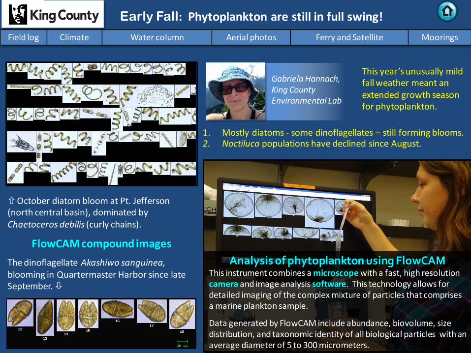
October diatom bloom at Pt. Jefferson (north central basin), dominated by Chaetoceros debilis (curly chains).
FlowCAM compound images
The dinoflagellate Akashiwo sanguinea, blooming in Quartermaster Harbor since late September.
Analysis of phytoplankton using FlowCAM This instrument combines a microscope with a fast, high resolution camera and image analysis software. This technology allows for detailed imaging of the complex mixture of particles that comprises a marine plankton sample.
Data generated by FlowCAM include abundance, biovolume, size distribution, and taxonomic identity of all biological particles with an average diameter of 5 to 300 micrometers.
1. Mostly diatoms - some dinoflagellates – still forming blooms. 2. Noctiluca populations have declined since August.
Gabriela Hannach, King County Environmental Lab
This year’s unusually mild fall weather meant an extended growth season for phytoplankton.

Are Algal Blooms Harmful? The majority of algal blooms are not harmful. However, there are several species of phytoplankton that cause Harmful Algal Blooms (HABs). HABs can negatively impact the health of humans and animals that consume shellfish (such as clams, mussels, and oysters) that are exposed to these blooms.
Bloom of the HAB species Dinophysis
Photo taken by Laura Hermanson
All About Phytoplankton: Part 2
HAB species are harmful because they contain certain toxins. Since shellfish are filter feeders, they consume these harmful species in large quantities and accumulate the toxins in their tissues. These toxins do not affect the shellfish, but they can affect anyone who eats the shellfish.
All About Phytoplankton: Part 2
Personal flight impression 10-29-2014 Field log Climate Water column Aerial photos Ferry and Satellite Moorings

What Causes Harmful Algal Blooms? Illness caused by eating shellfish that contain HAB toxins can cause gastric distress, short-term memory loss, loss of motor control, and in extreme cases, death due to respiratory arrest. It sounds scary, but there are ways to protect yourself.
How can you stay safe?
Know before you dig! The Department of Health makes it easy to locate areas that are safe for recreational harvest. They also monitor commercial growing areas. Visit their website for shellfish safety information and beach closure status. The Department of Ecology is now partnering with DOH to help monitor for HABs.
Alexandrium is a dinoflagellate that causes Paralytic Shellfish
Poisoning (PSP). Toxin Produced: Saxitoxin
Dinophysis is a dinoflagellate that causes Diarrhetic Shellfish
Poisoning (DSP). Toxin Produced: Okadaic Acid
Pseudo-nitzschia is a diatom that causes Amnesic Shellfish
Poisoning (ASP). Toxin Produced: Domoic Acid
Personal Field Impression
Phytoplankton photos from King County Marine Monitoring Program: http://green.kingcounty.gov/marine/Photos.aspx
Shellfish Safety Website: https://fortress.wa.gov/doh/eh/maps/biotoxin/biotoxin.html
Field log Weather Water column Aerial photos Ferry and Satellite Moorings
Personal flight impression 10-29-2014 Field log Climate Water column Aerial photos Ferry and Satellite Moorings

Field log Climate Water column Aerial photos Ferry and Satellite Moorings
Climate and natural influences before 10-29-2014
Summary: Air temperatures have generally been above normal continuing the trend of the past seven months. Precipitation levels are increasing. The remnants of Hurricane Ana affect the PNW, aided by warmer-than-normal sea surface temperatures. Cloud Cover has been lower than normal. Conversely sunshine has been above normal. River flows are below normal for the Fraser River, but normal to above normal elsewhere. PDO remains in the warm phase, and upwelling is below normal. Oceanic intrusions of low DO water were not predicted.
lower higher expected No data
New section! Climate and natural influences are conditions that influence our marine waters, including weather, rivers, and the adjacent ocean (previously called Weather). For an explanation of the figure, see: http://www.ecy.wa.gov/programs/eap/mar_wat/weather.html, page 26.
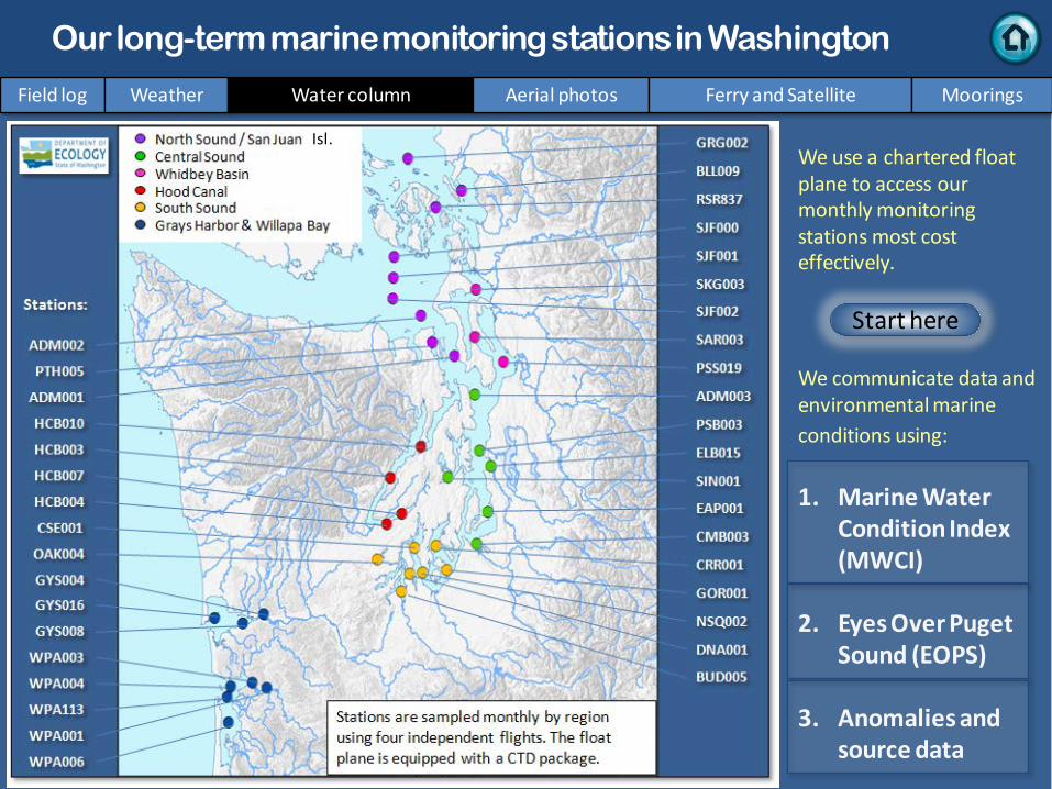
We use a chartered float plane to access our monthly monitoring stations most cost effectively. We communicate data and environmental marine conditions using: 1. Marine Water
Condition Index (MWCI)
2. Eyes Over Puget Sound (EOPS)
3. Anomalies and source data
Field log Weather Water column Aerial photos Ferry and Satellite Moorings
Our long-term marine monitoring stations in Washington
Start here
Isl.
.

Salinity low inside P. Sound Oxygen lower September, 2014: Temperature warmer
Physical conditions tracked in statistically historic context
Puget Sound was warmer in 2013 than 2014. Early 2014 started colder and saltier with lower oxygen, then became fresher and warmer. At the end of summer, temperatures are high in South Sound and salinities and dissolved oxygen are low in Central Sound. DO remains high in Hood Canal.
Field log Weather Water column Aerial photos Ferry and Satellite Moorings

a) Pacific Decadal Oscillation Index (PDO, temperature) (explanation) b) Upwelling Index (anomalies) (Upwelling, low oxygen) (explanation) c) North Pacific Gyre Oscillation Index (NPGO, productivity) (explanation)
NPG
O (x10)
PDO
/Upw
ellin
g Ind
ex
Three-year running average of PDO, Upwelling, and NPGO indices scores
Ocean boundary conditions have been favorable for water quality in Puget Sound: (a) colder water (PDO), (b) less upwelled low oxygen and high nutrient ocean water reaching Puget Sound (Upwelling Index), and (c) higher surface productivity along the coast (NPGO). Where are we heading next?
Field log Weather Water column Aerial photos Ferry and Satellite Moorings
.
The ocean affects water quality: Ocean Climate Indices
-25 -20 -15 -10 -5 0 5 10 15 20 25
-1.5
-1
-0.5
0
0.5
1
1.5
1945 1950 1955 1960 1965 1970 1975 1980 1985 1990 1995 2000 2005 2010 2015
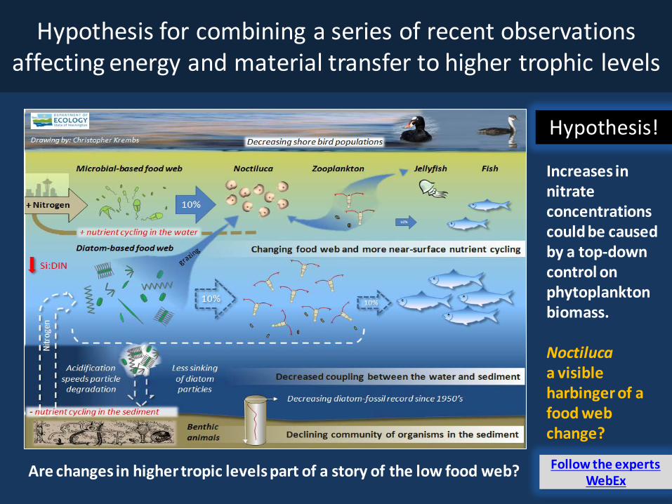
Is the food web changing in Puget Sound?
Follow the experts WebEx
Hypothesis! Increases in nitrate concentrations could be caused by a top-down control on phytoplankton biomass. Noctiluca a visible harbinger of a food web change?
Hypothesis for combining a series of recent observations affecting energy and material transfer to higher trophic levels
Are changes in higher tropic levels part of a story of the low food web?

Summary: Aerial photography 10-29-2014
Very dense and large patches of jellyfish seen in finger inlets of South Sound. Red-brown blooms remain strong in smaller bays inside Puget Sound, particularly South Sound. Suspended sediment increasingly visible.
Field log Weather Water column Aerial photos Ferry and Satellite Moorings
Start here Mixing and Fronts: Developed fronts and mixing visible by colored surface water. Very pronounced in Dabob Bay, Hood Canal, and Samish Bay.
Debris: Organic debris still numerous in Whidbey Basin and finger inlets of South Sound.
Visible blooms: Green-brown: Oakland Bay, Saratoga Passage. Red-brown: Southern finger inlets of South Sound, Sinclair Inlet.
Jellyfish: Jellyfish patches very large, dense, and numerous in southern inlets of South Sound (Totten, Eld, and Budd Inlets).
Bloo
m
Debr
is
Fron
t
Suspended sediment: Suspended sediments near shore due to wind and waves or rivers. Port Susan, Skagit and Samish Bays rich with sediment.
Plum
e
Moon jelly smack next to plane, Budd Inlet
Moon jelly smack next to plane, Budd Inlet
1 2 4 15 16 17 20 19 18
1 2 7 9 13 14
15 16 17 20 19 18
1 5 6 8 9
12
1 2 3 8 13 16 17
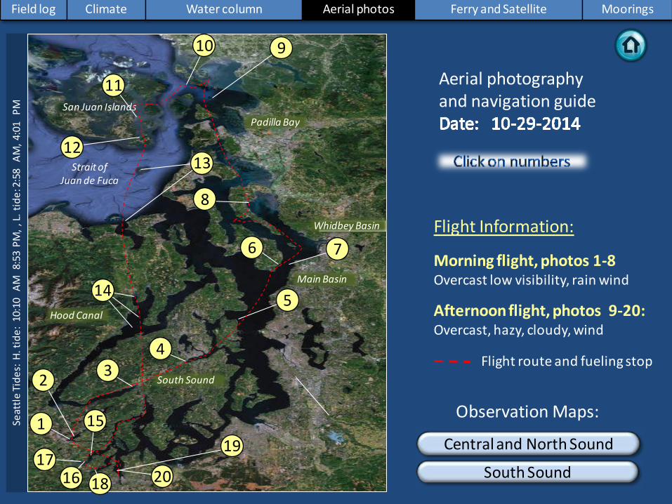
Strait of Juan de Fuca
San Juan Islands Padilla Bay
Main Basin
Hood Canal
South Sound
Field log Climate Water column Aerial photos Ferry and Satellite Moorings
Observation Maps:
Afternoon flight, photos 9-20: Overcast, hazy, cloudy, wind
Flight Information:
Morning flight, photos 1-8 Overcast low visibility, rain wind
8
11
10
15
Aerial photography and navigation guide
20
6
Central and North Sound
South Sound
Seat
tle Ti
des:
H. t
ide:
10:
10 A
M 8
:53
PM, ,
L. ti
de: 2
:58
AM
, 4:0
1 P
M
7
12
Whidbey Basin
5
Flight route and fueling stop
17 16
9
18
3 2
1
4
13
14
19

Debr
is
Tidal mixing of sediment-rich water with green-brown bloom bordered with lines of organic debris. Location: Off Bell Road, Oakland Bay (South Sound), 10:55 AM.
1 Aerial photography 10-29-2014 Navigate
Field log Climate Water column Aerial photos Ferry and Satellite Moorings
sediment
Debr
is
cloud reflections
Bloo
m
Plum
e

2 Navigate Aerial photography 10-29-2014 Field log Climate Water column Aerial photos Ferry and Satellite Moorings
Red-brown bloom and green-brown bloom separated by tidal fronts that accumulate organic debris. Location: Off Eagle Point, Oakland Bay (South Sound), 10:56 AM.
Debr
is
Debr
is
Debr
is
Bloo
m
Bloo
m
boat
boat

3 Navigate Aerial photography 10-29-2014
Long organic debris line and boggy freshwater entering into cove from Union River. Location: Lynch Cove (Hood Canal), 11:08 AM.
Field log Climate Water column Aerial photos Ferry and Satellite Moorings
Debr
is

4 Navigate
Field log Climate Water column Aerial photos Ferry and Satellite Moorings
Aerial photography 10-29-2014
Red-brown bloom in inner Inlet. Location: Sinclair Inlet (Central Sound), 11:18 AM.
Bloo
m
boat
sediment

5 Navigate Aerial photography 10-29-2014 Field log Climate Water column Aerial photos Ferry and Satellite Moorings
Suspended sediments detaching from shoreline due to currents. Location: Off Fay Bainbridge Park, Bainbridge Island, Port Madison (Central Sound), 11:25 AM.
fishing boat
sediment
sediment
sediment

Suspended sediments from river and/or shore erosion being transported northward. Location: Off Glendale Road, south Whidbey Island (Whidbey Basin), 11:33 AM.
6 Navigate Aerial photography 10-29-2014 Field log Climate Water column Aerial photos Ferry and Satellite Moorings
sediment sediment
sediment
sediment sediment sediment

Northerly winds pushing back Whidbey Basin water. Strong front delineating sediment-rich water. Location: Mukilteo (Whidbey Basin), 11:33 AM.
7 Navigate Aerial photography 10-29-2014 Field log Climate Water column Aerial photos Ferry and Satellite Moorings
barge ferry

Black surface debris and sediment-rich water. Location: Near Triangle Cove, Port Susan (Whidbey Basin), 12:35 PM.
8 Navigate Aerial photography 10-29-2014 Field log Climate Water column Aerial photos Ferry and Satellite Moorings
Debr
is
Debr
is
sediment

Sediment-rich water originating in Samish Bay flowing front. Water upwells and mixes near island. Location: Vendovi Island, Samish Bay (North Sound), 1:38 PM.
9 Navigate Aerial photography 10-29-2014 Field log Climate Water column Aerial photos Ferry and Satellite Moorings
Plum
e
boat
boat boat
ship
sediment

10 Navigate Aerial photography 10-29-2014
Sediment-rich water mixes into Rosario Strait. Location: West of Lummi Island (North Sound), 2:05 PM.
Field log Climate Water column Aerial photos Ferry and Satellite Moorings
sediment
mixing

11 Navigate Aerial photography 10-29-2014
Turquoise water of Lopez Sound with shadows from clouds. Location: Frost Island, Lopez Sound (San Juan Islands), 2:41 PM.
Field log Climate Water column Aerial photos Ferry and Satellite Moorings
boat
ferry boat

Red-brown bloom in distinct patches in bay. Location: Mud Bay, Lopez Sound (San Juan Islands), 2:45 PM.
12 Navigate
Field log Climate Water column Aerial photos Ferry and Satellite Moorings
Aerial photography 10-29-2014
Bloo
m
Bloo
m
Bloo
m
Bloo
m
boat

A. B.
Beach erosion due to waves; kelp beds and debris lines. Location: A. Smith Island, B. Cape George, Discovery Bay (Strait of Juan de Fuca), 1:22 PM.
13 Navigate Aerial photography 10-29-2014 Field log Climate Water column Aerial photos Ferry and Satellite Moorings
2:50 PM 2:58 PM
Debr
is
house sediment
sediment
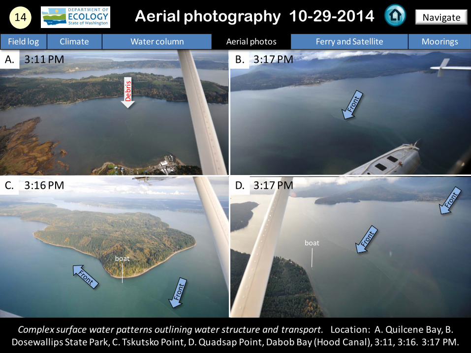
A. B.
C. D.
Complex surface water patterns outlining water structure and transport. Location: A. Quilcene Bay, B. Dosewallips State Park, C. Tskutsko Point, D. Quadsap Point, Dabob Bay (Hood Canal), 3:11, 3:16. 3:17 PM.
14 Navigate
Field log Climate Water column Aerial photos Ferry and Satellite Moorings
Aerial photography 10-29-2014
3:11 PM
3:16 PM
3:17 PM
3:17 PM
boat
boat
Debr
is

15 Navigate
Field log Climate Water column Aerial photos Ferry and Satellite Moorings
Strong red-brown bloom, suspended sediment, turquoise water, and jellyfish patches. Location: Off Baron Point, Totten Inlet (South Sound), 3:41 PM.
Aerial photography 10-29-2014
jellyfish
jellyfish
jellyfish
jellyfish jellyfish
jellyfish
Bloo
m
Plum
e
boat

16 Navigate
Strong red-brown bloom, suspended sediment, turquoise water, and jellyfish patches. Location: Hudson Cove, Totten Inlet (South Sound), 3:42 PM.
Aerial photography 10-29-2014 Field log Climate Water column Aerial photos Ferry and Satellite Moorings
jellyfish
jellyfish jellyfish
jellyfish jellyfish
jellyfish
Debr
is
Bloo
m
shellfish pen
Boat

17 Navigate
Field log Climate Water column Aerial photos Ferry and Satellite Moorings
Strong red-brown bloom, suspended sediment, turquoise water, and jellyfish patches. Location: Burns Point, Totten Inlet (South Sound), 3:44 PM.
Aerial photography 10-29-2014
jellyfish
jellyfish Debr
is
Bloo
m
Plum
e
boat

18 Navigate
Field log Climate Water column Aerial photos Ferry and Satellite Moorings
Red-brown bloom and patches of jellyfish. Location: Off Shell Point, Eld Inlet (South Sound), 3:46 PM.
Aerial photography 10-29-2014
jellyfish
jellyfish
jellyfish
jellyfish jellyfish
jellyfish
Bloo
m
Bloo
m
boat

A. B.
19 Navigate
Field log Climate Water column Aerial photos Ferry and Satellite Moorings
Red-brown bloom and extensive smacks of moon jellies both in size and density. Location: A. Outer bay, B. Inner bay of Budd Inlet (South Sound), 3:50 PM.
Aerial photography 10-29-2014
Bloo
m
jellyfish jellyfish
jellyfish jellyfish
jellyfish
jellyfish
jellyfish
jellyfish
jellyfish jellyfish jellyfish jellyfish
jellyfish

A.
20 Navigate
Extensive smacks of moon jellies both in size and density with pinkish tint. Location: A. On the water, B. From air showing location on the water, Budd Inlet (South Sound), 3:50 PM.
Aerial photography 10-29-2014 Field log Climate Water column Aerial photos Ferry and Satellite Moorings
B.
jellyfish jellyfish
jellyfish
Bloo
m
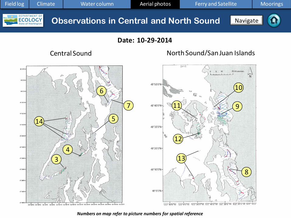
North Sound/San Juan Islands
Numbers on map refer to picture numbers for spatial reference
Date: 10-29-2014
Central Sound
Aerial photography observations in Central Sound Observations in Central and North Sound Navigate
Field log Climate Water column Aerial photos Ferry and Satellite Moorings
5
6 10
9 11
12 4
3
7
8
13
14

Date: 10-29-2014
Observations in Hood Canal and South Sound
Numbers on map refer to picture numbers for spatial reference
Navigate
Field log Climate Water column Aerial photos Ferry and Satellite Moorings
South Sound
17 18 19
20
1
2
15
16

Legend to map annotations
Comments: Maps are produced by observers during and after flights. They are intended to give an approximate reconstruction of the surface conditions on scales that connect to and overlap with satellite images in the section that follows. Debris: Debris can be distinguished into natural and anthropogenic debris floating at the surface sensu Moore and Allen (2000). The majority of organic debris in Puget Sound is natural and mixed with discarded man-made pieces of plastic, wood, etc. From the plane, we cannot differentiate the quality of debris at the surface and therefore, call it for reasons of practicality just “debris”. S.L. Moore, M. J. Allen. 2000. Distribution of Anthropogenic and Natural Debris on the Mainland Shelf of the Southern California Bight. Marine Pollution Bulletin, 40(1): 83–88.
Navigate
Field log Climate Water column Aerial photos Ferry and Satellite Moorings

Current Conditions:
Cooler temperatures and an increased fresh water at the triple junction in Central Sound are seen in the salinity and color characteristics of the water (CDOM).
Brandon Sackmann Contact: [email protected]
Hardware upgrades on the Victoria Clipper IV successfully restored near real-time data collection as of
July 23, 2014; we are back online!
Field log Climate Water column Aerial photos Ferry and Satellite Moorings
Ferry and satellite observations 10-29-2014
Start here
27 October 2014

The data logging upgrade that was done in July continues to be very successful! Data are uploaded daily to: http://107.170.217.21/VictoriaClipper30/level0/.
Field log Climate Water column Aerial photos Ferry and Satellite Moorings
Ferry and satellite observations 10-29-2014
When we serviced our fluorometer on Tuesday, we found plastic pieces in the sea chest and aquatic plant on the sensor. We have also found
feathers, small fish, sea grass, etc.
One optical lens on the fluorometer has UV rays, so we wear safety glasses
with UV protection.
Tools and gear are set up for easy access.
Removing bolts from the sea chest to access the fluorometer.

Mooring observations and trends 10-17-2014 to 10-30-2014
Field log Climate Water column Aerial photos Ferry and Satellite Moorings
At Mukilteo, recent rains increased river flows and brought fresh water to our moorings during outgoing tides. In the upper mooring, tidal influences can be seen in the upper left plot. The deeper mooring measured high salinity and increased oxygen. For the entire month of October, temporal trends of temperature followed somewhat similarly to the tidal cycle (see next slide).
2-6 m depth
Dissolved oxygen not measured
12-16 m depth
These plots show the probability of observations over the past two-week period. High probability shown in warm colors. Left Panels: Density is defined by salinity and temperature. Right Panel: Dissolved oxygen concentration in relation to salinity.
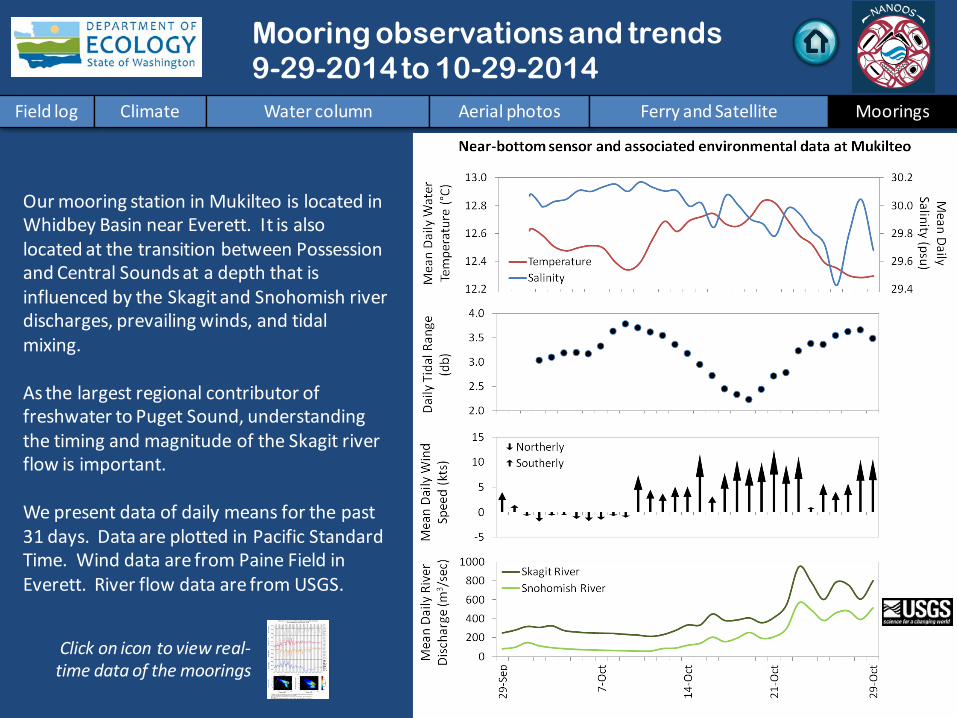
Mooring observations and trends 9-29-2014 to 10-29-2014
Click on icon to view real-time data of the moorings
Field log Climate Water column Aerial photos Ferry and Satellite Moorings
Our mooring station in Mukilteo is located in Whidbey Basin near Everett. It is also located at the transition between Possession and Central Sounds at a depth that is influenced by the Skagit and Snohomish river discharges, prevailing winds, and tidal mixing. As the largest regional contributor of freshwater to Puget Sound, understanding the timing and magnitude of the Skagit river flow is important. We present data of daily means for the past 31 days. Data are plotted in Pacific Standard Time. Wind data are from Paine Field in Everett. River flow data are from USGS.

Mooring observations and trends Mukilteo 2010 to 2014
Field log Climate Water column Aerial photos Ferry and Satellite Moorings
Please note that data are provisional. Data are in GMT.
At the Mukilteo mooring, we use the near-bottom sensor (12-16 m deep) to measure significant inter-annual variability in temperature, salinity, and dissolved oxygen. Inter-annual variability is shown over an almost 5-year period. All three variables show strong seasonality. Through 2014, trends in salinity and dissolved oxygen appear to decline whereas trends in temperature are similar to 2013. For October, temperature and oxygen are higher than the past four years. September 2014 data for salinity and oxygen are invalid after we found the sensor sitting on sediment. Our bath verifications indicated the dissolved oxygen sensor failed in early July and thus, dissolved oxygen data for July 2014 is from latter half of the month.

Access mooring data:
ftp://www.ecy.wa.gov/eap/Mooring_Raw/Puget_S
ound/
Ferry and satellite : [email protected]
Get data from Ecology’s Marine Monitoring Programs
Long–Term Monitoring Network
Real–Time Sensor Network
Access core monitoring data: http://www.ecy.wa.gov/apps/eap/marinewq/mwda
taset.asp
Ecology’s long-term marine monitoring stations
Ferry track
Field log Climate Water column Aerial photos Ferry and Satellite Moorings
River and Stream Water Quality Monitoring
http://www.ecy.wa.gov/programs/eap/fw_riv/rv_main.html
Discontinued (funding cuts)

You may subscribe or unsubscribe to the Eyes Over Puget Sound email listserv by going to: http://listserv.wa.gov/cgi-bin/wa?A0=ECOLOGY-EYES-OVER-PUGET-SOUND
Many thanks to our business partners: Clipper Navigations, Swantown Marina, and Kenmore Air.
We are looking for feedback to improve our products.
Dr. Christopher Krembs
Marine Monitoring Unit Environmental Assessment Program
WA Department of Ecology
Field log Climate Water column Aerial photos Ferry and Satellite Moorings