Eops 2014 11_17
44
November 17, 2014 Surface Conditions Report Eyes Over Puget Sound Field log Climate Water column Aerial photos Ferry and Satellite Moorings Publication No. 14-03-079 Start here Up-to-date observations of visible water quality conditions in Puget Sound and the Strait of Juan de Fuca
-
Upload
christopher-krembs -
Category
Education
-
view
105 -
download
0
Transcript of Eops 2014 11_17

November 17, 2014 Surface Conditions Report
Eyes Over Puget Sound Field log Climate Water column Aerial photos Ferry and Satellite Moorings
Publication No. 14-03-079
Start here
Up-to-date observations of visible water quality conditions in Puget Sound and the Strait of Juan de Fuca

Personal field log p. 3 Meet our BEACH program. Climate conditions p. 5 A recent cold spell affects the Puget Sound lowlands, softening an 8-month trend of warmer temperatures. The ocean remains warm. Water column p. 6 Puget Sound is a lot warmer at the end of 2014 with new max temps observed throughout the Sound! Salinity and dissolved oxygen are mostly expected. The higher DO and cold temperature anomaly in Hood Canal is disappearing. Moorings p. 40 Water temperature is cooling and this accompanies reduced river flows of the past week. Aerial photography p. 10 Abundant patches of jellyfish seen in finger inlets of South Sound. Red-brown blooms remain strong in smaller bays of South Sound coinciding with jellyfish. Suspended sediment increasingly visible as a result of increased rain, wind, and waves. Ferry and satellite p. 35 Cold water from Whidbey Basin moves into Puget Sound at the Triple Junction; associated with moderate levels chlorophyll fluorescence. Increased turbidity seen throughout the Strait of Georgia.
LO
NG
-T
ER
M
MA
RIN
E
MO
NIT
OR
ING
U
NIT
Mya Keyzers Laura Hermanson
Joe Leatherman
Skip Albertson
Dr. Christopher Krembs
Guest: Dr. Brandon Sackmann,
Integral
Julia Bos Suzan Pool
Editorial assistance provided by: Suzan Pool, Carol Maloy, Laura Hermanson
Marine conditions from 11-17-2014 at a glance Field log Climate Water column Aerial photos Ferry and Satellite Moorings
Please give us feedback

The BEACH Program helps to reduce the risk of disease for people who play in saltwater by:
What is the Washington BEACH Program?
Notifying users when bacteria results are high.
Educating the public about risks associated with pollution and what we can do to reduce the risks.
Contact with fecal bacteria contaminated waters can result in gastroenteritis, skin rashes, upper respiratory infections, and other illnesses. The Washington BEACH Program is led jointly by the Washington State Department of Ecology and Department of Health. Our BEACH partners include county and local health jurisdictions, Tribes, and volunteers.
Monitoring bacteria levels at popular, high risk beaches.
The BEACH program 11-17-2014 Field log Climate Water column Aerial photos Ferry and Satellite Moorings

Keeping Washington beaches healthy -- we're all in this together!
Stay updated about water quality at your beaches by keeping up with us on: Fecal Matters Blog: http://ecologywa.blogspot.com/search/label/Fecal%20matters Facebook: https://www.facebook.com/WABEACH Twitter: https://twitter.com/ecologywa Find public beaches and info on beach closures: https://fortress.wa.gov/ecy/coastalatlas/
Personal Field Impression Field log Weather Water column Aerial photos Ferry and Satellite Moorings
The BEACH program 11-17-2014 Field log Climate Water column Aerial photos Ferry and Satellite Moorings

Field log Climate Water column Aerial photos Ferry and Satellite Moorings
Climate and natural influences before 11-17-2014
Summary: Air temperatures continue an 8-month trend, though a recent cold period introduces cold dense air into the Puget Sound lowlands. Precipitation levels have been above normal, but nil during the past week as temperatures dropped. Cloud Cover has been near normal. River flows are beginning to climb above normal across the region. PDO remains in the warm phase, and upwelling is below normal.
lower higher expected No data
New section! Climate and natural influences are conditions that influence our marine waters, including weather, rivers, and the adjacent ocean (previously called Weather). For an explanation of the figure, see: http://www.ecy.wa.gov/programs/eap/mar_wat/weather.html, page 26.

We use a chartered float plane to access our monthly monitoring stations. We communicate data and environmental marine conditions using: 1. Marine Water
Condition Index (MWCI)
2. Eyes Over Puget Sound (EOPS)
3. Anomalies and source data
Field log Weather Water column Aerial photos Ferry and Satellite Moorings
Our long-term marine monitoring stations in Washington
Start here
Isl.
.

Physical conditions tracked in statistically historic context Field log Weather Water column Aerial photos Ferry and Satellite Moorings
Salinity lower at Coast Oxygen expected Oct. 2014: Temperature – New Max!
Puget Sound is a lot warmer at the end of 2014 with new max temps observed throughout the Sound! Early 2014 started colder and saltier with lower oxygen, then became fresher and warmer. Salinity is within expected ranges and dissolved oxygen are variable throughout the regions. The higher DO anomaly in Hood Canal is disappearing.
Red boxes show that the water measured in
October is warmer than any of our measurements
since 1999
Explore profiles at all stations

a) Pacific Decadal Oscillation Index (PDO, temperature) (explanation) b) Upwelling Index (anomalies) (Upwelling, low oxygen) (explanation) c) North Pacific Gyre Oscillation Index (NPGO, productivity) (explanation)
NPG
O (x10)
PDO
/Upw
ellin
g Ind
ex
Three-year running average of PDO, Upwelling, and NPGO indices scores
Ocean boundary conditions have been favorable for water quality in Puget Sound: (a) colder water (PDO), (b) less upwelled low oxygen and high nutrient ocean water reaching Puget Sound (Upwelling Index), and (c) higher surface productivity along the coast (NPGO). Where are we heading next?
Field log Weather Water column Aerial photos Ferry and Satellite Moorings
.
The ocean affects water quality: Ocean Climate Indices
-25 -20 -15 -10 -5 0 5 10 15 20 25
-1.5
-1
-0.5
0
0.5
1
1.5
1945 1950 1955 1960 1965 1970 1975 1980 1985 1990 1995 2000 2005 2010 2015

Is the food web changing in Puget Sound?
Follow the experts WebEx
Hypothesis! Increases in nitrate concentrations could be caused by a top-down control on phytoplankton biomass. Noctiluca a visible harbinger of a food web change?
Hypothesis for combining a series of recent observations affecting energy and material transfer to higher trophic levels
Are changes in higher tropic levels part of a story of the low food web?

Summary: Aerial photography 11-17-2014
Abundant patches of jellyfish seen in finger inlets of South Sound. Red-brown blooms remain strong in smaller bays of South Sound and coincide with jellyfish. A localized bloom seen off Tokeland. Suspended sediment increasingly visible as a result of increased rain, wind, and waves.
Field log Weather Water column Aerial photos Ferry and Satellite Moorings
Start here Mixing and Fronts: Developed tidal fronts and mixing visible by colored surface water. Very pronounced in Grays Harbor.
Debris: Organic debris and foam forming in patches near mudflats, river plumes, and tidal fronts as a result of stronger winds and higher river flows.
Visible blooms: Red-brown: Southern finger inlets of South Sound and very localized near Kindred Island, Willapa Bay.
Jellyfish: Jellyfish patches very numerous in southern inlets of South Sound (Totten, Eld, and Budd Inlets).
Bloo
m
Debr
is
Fron
t Suspended sediment: As a result of recent precipitation, many river influenced areas show large sediment plumes. Strong winds, tidal currents, and dredging affect sediment re-suspension regionally and locally.
Plum
e
Beautiful Niaviakum River, Willapa Bay
Mudflats near Smith Creek, Willapa Bay
1 2 20 19
5 7 8 9 10 12
4 5 6 8 9 10 13 14 15 17
1 2 12 17 20 19
2 3 5 7 10 11 12 13 14 17 20 18

Grays Harbor
Willapa Bay
Field log Climate Water column Aerial photos Ferry and Satellite Moorings
Observation Maps:
Afternoon flight, photos 13-20: Sunny, cold, winds increasing
Flight Information:
Morning flight, photos 1-12 Sunny, cold, high visibility
8
11
10
15
Aerial photography and navigation guide
20
6
Coast
South Sound
Seat
tle Ti
des:
H. t
ide:
1:1
5 A
M 1
2:58
PM
, , L.
tide
: 6:2
9 A
M, 8
:00
PM
7
12
5
Flight route and fueling stop
17
9
18
3 2
1
4
13 14
19
16

Numerous jellyfish smacks with underlying red-brown bloom. Location: Off Little Tykle Cove, Budd Inlet (South Sound), 9:25 AM.
1 Aerial photography 11-17-2014 Navigate
Field log Climate Water column Aerial photos Ferry and Satellite Moorings
Bloo
m
jellyfish
jellyfish
jellyfish
jellyfish
jellyfish
jellyfish
jellyfish
jellyfish
jellyfish

A.
B. C.
2 Navigate Aerial photography 11-17-2014 Field log Climate Water column Aerial photos Ferry and Satellite Moorings
Red-brown bloom, organic debris, jellyfish smacks, and edge of river plume with internal waves. Location: A. Flapjack Point, B. Shell Point, C. Snyder Cove, Eld Inlet (South Sound).
Debr
is
Bloo
m
Bloo
m
boat
internal waves
9:27 AM 9:27 AM
1:31 PM
jellyfish jellyfish
jellyfish
Debr
is
boat
Bloo
m

3 Navigate Aerial photography 11-17-2014
Long organic debris line in Chehalis River. Location: Cosmopolis (Grays Harbor), 9:51 AM.
Field log Climate Water column Aerial photos Ferry and Satellite Moorings
Debr
is

4 Navigate
Field log Climate Water column Aerial photos Ferry and Satellite Moorings
Aerial photography 11-17-2014
Sediment-rich river plume hugging the southern shoreline of Grays Harbor and Chehalis River water. Location: Off Stafford Creek (Grays Harbor), 11:18 AM.
Dredging barge
sediment
Plum
e
Plum
e

5 Navigate Aerial photography 11-17-2014 Field log Climate Water column Aerial photos Ferry and Satellite Moorings
Fronts where Chehalis River and local sediment-rich river waters meet marine water. Location: Off O’Leary Creek, south channel (Grays Harbor), 9:55 AM.
sediment from dredging
Plum
e
Plum
e
Debr
is

Suspended sediments from dredging. Location: Between North and South Channel, (Grays Harbor), 9:56 AM.
6 Navigate Aerial photography 11-17-2014 Field log Climate Water column Aerial photos Ferry and Satellite Moorings
sediment
Dredging barge

Front where Chehalis River water meets Grays Harbor water. Location: North Channel, off airport (Grays Harbor), 11:33 AM.
7 Navigate Aerial photography 11-17-2014 Field log Climate Water column Aerial photos Ferry and Satellite Moorings
Plum
e
Debr
is

Dark humic-rich water entering bay and locally mixing with sediment-rich water. Location: Armstrong Bay (Grays Harbor), 10:28 AM.
8 Navigate Aerial photography 11-17-2014 Field log Climate Water column Aerial photos Ferry and Satellite Moorings
sediment
sediment
Plum
e
rescue helicopter

Suspended sediment from wave, tidal currents, and water from Armstrong Bay mix around the point. Location: Damon Point (Grays Harbor), 10:30 AM.
9 Navigate Aerial photography 11-17-2014 Field log Climate Water column Aerial photos Ferry and Satellite Moorings
Plum
e mixing sediment

10 Navigate Aerial photography 11-17-2014
Surface water of different origins (South and North Bay) meeting at the entrance to Grays Harbor. Location: Damon Point (Grays Harbor), 10:30 AM.
Field log Climate Water column Aerial photos Ferry and Satellite Moorings
large ship
mixing
Debr
is

11 Navigate Aerial photography 11-17-2014
Large patch of organic debris near tidally exposed sandbars at the entrance to Willapa Bay. Location: Entrance to Willapa Bay (Willapa Bay), 10:39 PM.
Field log Climate Water column Aerial photos Ferry and Satellite Moorings
Debr
is

A. B.
Red-brown bloom mixed with local humic-rich, dark freshwater and organic debris along tide lines. Location: A. On the water, B. Above Tokeland (Willapa Bay), 10:44 AM.
12 Navigate
Field log Climate Water column Aerial photos Ferry and Satellite Moorings
Aerial photography 11-17-2014
Bloo
m
Debr
is

A. B.
Suspended sediment and debris line along Naselle River plume blown by strong wind. Location: A. Long Island Slough, B. Chetlo Harbor, Naselle River (Willapa Bay), 12:20 PM.
13 Navigate Aerial photography 11-17-2014 Field log Climate Water column Aerial photos Ferry and Satellite Moorings
sediment
Plum
e
Plum
e
Debr
is

Water with increasing suspended sediment content towards Ocean Park as a result of southeasterly winds. Location: Nahcotta Channel (Willapa Bay), 12:25 PM.
14 Navigate
Field log Climate Water column Aerial photos Ferry and Satellite Moorings
Aerial photography 11-17-2014
Plum
e
Debr
is

15 Navigate
Field log Climate Water column Aerial photos Ferry and Satellite Moorings
Sediment-rich water meeting dark humic-rich water of the Espy Slough. Location: Off Port of Peninsula, Ocean Park (Willapa Bay), 12:26 PM.
Aerial photography 11-17-2014
Plum
e
Plum
e

16 Navigate
Exposed mudflats where Palix and Niawiakum rivers meet. Location: Bay Center (Willapa Bay), 12:31 PM.
Aerial photography 11-17-2014 Field log Climate Water column Aerial photos Ferry and Satellite Moorings
boat

17 Navigate
Field log Climate Water column Aerial photos Ferry and Satellite Moorings
Red-brown bloom and water with suspended sediment meet at head of bay. Location: Oyster Bay, Totten Inlet (South Sound), 1:25 PM.
Aerial photography 11-17-2014
boat
Debr
is
Plum
e
Bloo
m
Plum
e

18 Navigate
Field log Climate Water column Aerial photos Ferry and Satellite Moorings
Long organic debris line in tidally flooded head of bay. Location: Little Skookum Inlet, Eld Inlet (South Sound), 1:26 PM.
Aerial photography 11-17-2014
Debr
is

19 Navigate
Field log Climate Water column Aerial photos Ferry and Satellite Moorings
Red-brown bloom being stirred by motorboat. Jellyfish and suspended sediment from shellfish operations. Location: Off Deepwater Point, Totten Inlet (South Sound), 1:25 PM.
Aerial photography 11-17-2014
Bloo
m
suspended sediment
boat wake jellyfish
jellyfish jellyfish
boat boat
boat
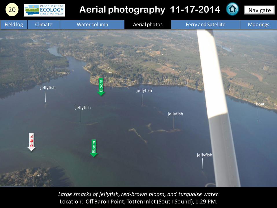
20 Navigate
Large smacks of jellyfish, red-brown bloom, and turquoise water. Location: Off Baron Point, Totten Inlet (South Sound), 1:29 PM.
Aerial photography 11-17-2014 Field log Climate Water column Aerial photos Ferry and Satellite Moorings
jellyfish
jellyfish jellyfish
jellyfish
boat
Bloo
m
Debr
is
Bloo
m
jellyfish

Numbers on map refer to picture numbers for spatial reference
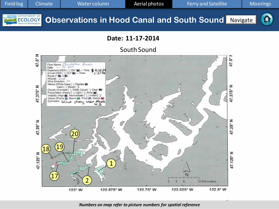
Date: 11-17-2014
Coast
Aerial photography observations in Central Sound Observations in Central and North Sound Navigate
Field log Climate Water column Aerial photos Ferry and Satellite Moorings
5
6
10
9
11
12
4 3
7 8
13 14
15
16
Date: 11-17-2014
Observations in Hood Canal and South Sound
Numbers on map refer to picture numbers for spatial reference
Navigate
Field log Climate Water column Aerial photos Ferry and Satellite Moorings
South Sound
17
18 19
20
1
2

Legend to map annotations
Comments: Maps are produced by observers during and after flights. They are intended to give an approximate reconstruction of the surface conditions on scales that connect to and overlap with satellite images in the section that follows. Debris: Debris can be distinguished into natural and anthropogenic debris floating at the surface sensu Moore and Allen (2000). The majority of organic debris in Puget Sound is natural and mixed with discarded man-made pieces of plastic, wood, etc. From the plane, we cannot differentiate the quality of debris at the surface and therefore, call it for reasons of practicality just “debris”. S.L. Moore, M. J. Allen. 2000. Distribution of Anthropogenic and Natural Debris on the Mainland Shelf of the Southern California Bight. Marine Pollution Bulletin, 40(1): 83–88.
Navigate
Field log Climate Water column Aerial photos Ferry and Satellite Moorings

Current Conditions: Cold water from Whidbey Basin moves into Puget
Sound at the Triple Junction; associated with moderate levels of chlorophyll fluorescence. Increased turbidity seen throughout the Strait of Georgia.
Brandon Sackmann Contact: [email protected]
Field log Climate Water column Aerial photos Ferry and Satellite Moorings
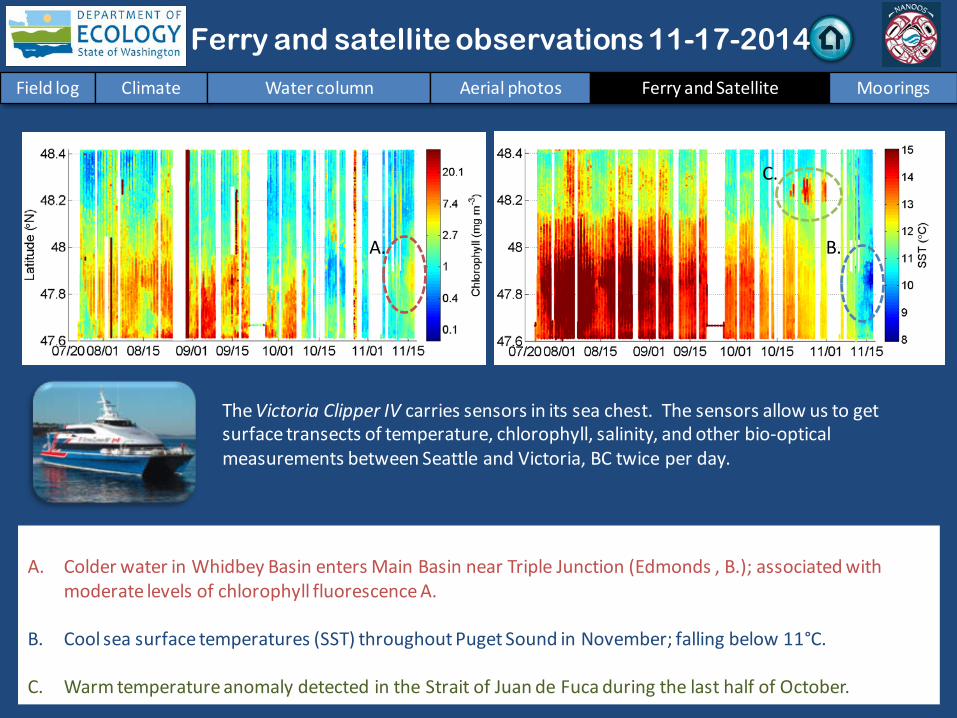
Ferry and satellite observations 11-17-2014
Start here
16 November 2014 16 November 2014
Field log Climate Water column Aerial photos Ferry and Satellite Moorings
Ferry and satellite observations 11-17-2014
A. Colder water in Whidbey Basin enters Main Basin near Triple Junction (Edmonds , B.); associated with
moderate levels of chlorophyll fluorescence A.
B. Cool sea surface temperatures (SST) throughout Puget Sound in November; falling below 11°C.
C. Warm temperature anomaly detected in the Strait of Juan de Fuca during the last half of October.
The Victoria Clipper IV carries sensors in its sea chest. The sensors allow us to get surface transects of temperature, chlorophyll, salinity, and other bio-optical measurements between Seattle and Victoria, BC twice per day.
B. A.
C.

Field log Climate Water column Aerial photos Ferry and Satellite Moorings
Ferry and satellite observations 11-17-2014
16 November 2014
Data from alternate route through Whidbey Basin in early November results in: A. lower salinity and B. high colored dissolved organic material (CDOM).
Increased river flows since 15 October are bringing in
cold/fresh and highly colored
water into Main Basin
from Whidbey Basin.
Note in reference to figure above:
A.
B.

Field log Climate Water column Aerial photos Ferry and Satellite Moorings
Ferry and satellite observations 11-17-2014
Thermal
Thermal imagery from Landsat 8 shows warmer waters in South Puget Sound, Lake Washington, and Lake Sammamish. Cooler waters in Whidbey Basin and southern end of Hood Canal.
True Color
11 November 2014

Field log Climate Water column Aerial photos Ferry and Satellite Moorings
Ferry and satellite observations 11-17-2014
MODIS-Aqua imagery from 15 November show sediment transport off the coast of Washington and turbid waters throughout the Strait of Georgia.
True Color Turbidity 11\15\2014
Imagery obtained from NASA’s OceanColor WEB, http://oceancolor.gsfc.nasa.gov/

Mooring observations and trends 11-04-2014 to 11-17-2014
Field log Climate Water column Aerial photos Ferry and Satellite Moorings
At Mukilteo, water temperature is decreasing for the winter and this accompanies reduced river flows of the past week. In the upper mooring, water mixing appears reduced to tidal influences. The deeper mooring detected more than one water mass. During the past month, an early November shift from SW storms to cold and dry weather influenced variability in salinity (see next slide).
2-6 m depth
Dissolved oxygen not measured
12-16 m depth
These plots show the probability of observations over the past two-week period. High probability shown in warm colors. Left Panels: Density is defined by salinity and temperature. Right Panel: Dissolved oxygen concentration in relation to salinity.

Mooring observations and trends 10-18-2014 to 11-17-2014
Click on icon to view real-time data of the moorings
Field log Climate Water column Aerial photos Ferry and Satellite Moorings
Our mooring station in Mukilteo is located in Whidbey Basin near Everett. It is also located at the transition between Possession and Central Sounds at a depth that is influenced by the Skagit and Snohomish river discharges, prevailing winds, and tidal mixing. As the largest regional contributor of freshwater to Puget Sound, understanding the timing and magnitude of the Skagit river flow is important. We present data of daily means for the past 31 days. Data are plotted in Pacific Standard Time. Wind data are from Paine Field in Everett. River flow data are from USGS.

Mooring observations and trends Mukilteo 2010 to 2014
Field log Climate Water column Aerial photos Ferry and Satellite Moorings
At the Mukilteo mooring, we use the near-bottom sensor (12-16 m deep) to measure significant inter-annual variability in temperature, salinity, and dissolved oxygen. This is typically near the pycnocline and the water with a high residence time in Whidbey Basin. Inter-annual variability is shown over a 5-year period. All three variables show strong seasonality. Since August, water temperature has been warmer than past years. In October and November, salinity is similar to or lower than past years and dissolved oxygen is higher than or similar to past years. September 2014 data for salinity and oxygen are invalid after we found the sensor sitting on sediment; data were removed. A sensor performance verification indicated the dissolved oxygen sensor failed in early July and thus, dissolved oxygen data for July 2014 are from latter half of the month.
Please note that data are provisional. Data are in GMT.
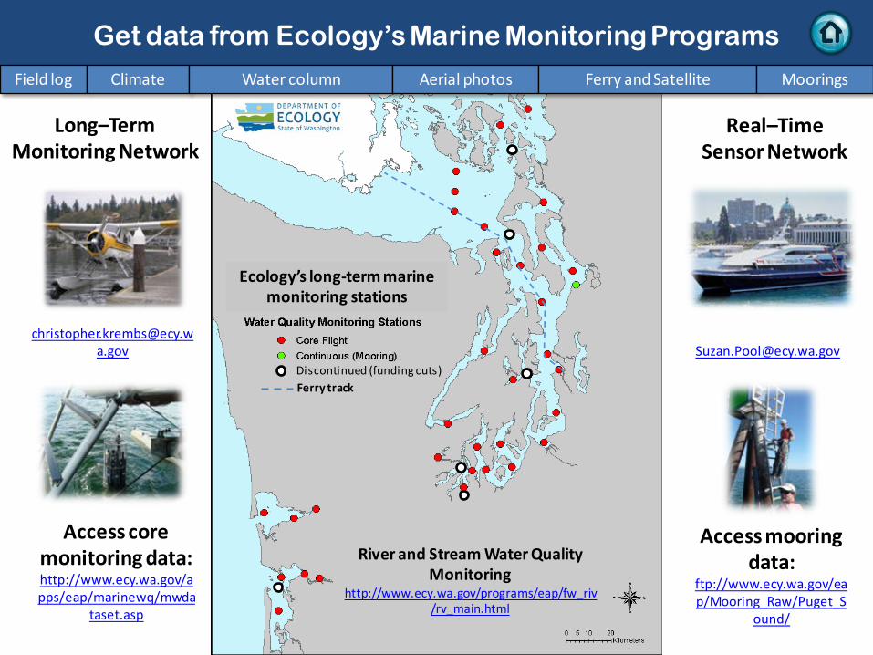
Access mooring data:
ftp://www.ecy.wa.gov/eap/Mooring_Raw/Puget_S
ound/
Ferry and satellite : [email protected]
Get data from Ecology’s Marine Monitoring Programs
Long–Term Monitoring Network
Real–Time Sensor Network
Access core monitoring data: http://www.ecy.wa.gov/apps/eap/marinewq/mwda
taset.asp
Ecology’s long-term marine monitoring stations
Ferry track
Field log Climate Water column Aerial photos Ferry and Satellite Moorings
River and Stream Water Quality Monitoring
http://www.ecy.wa.gov/programs/eap/fw_riv/rv_main.html
Discontinued (funding cuts)

You may subscribe or unsubscribe to the Eyes Over Puget Sound email listserv by going to: http://listserv.wa.gov/cgi-bin/wa?A0=ECOLOGY-EYES-OVER-PUGET-SOUND
Many thanks to our business partners: Clipper Navigations, Swantown Marina, and Kenmore Air.
We are looking for feedback to improve our products.
Dr. Christopher Krembs
Marine Monitoring Unit Environmental Assessment Program
WA Department of Ecology
Field log Climate Water column Aerial photos Ferry and Satellite Moorings