Eops 2012 01_30
29
Eyes Over Puget Sound Surface Conditions Report January, 30th 2012 Start here Up-to-date observations of visible water quality conditions in Puget Sound and the Strait of Juan de Fuca Field log Weather Water column Aerial photos Ferry and Satellite Moorings
-
Upload
christopher-krembs -
Category
Education
-
view
158 -
download
2
Transcript of Eops 2012 01_30

Eyes Over Puget Sound
Surface Conditions Report January, 30th 2012
Start here
Up-to-date observations of visible water quality conditions in Puget Sound and the Strait of Juan de Fuca
Field log Weather Water column Aerial photos Ferry and Satellite Moorings

LON
G-T
ERM
M
ARI
NE
MO
NIT
ORI
NG
UN
IT
Personal flight impression p. 3-4 January weather remains challenging but new flight plan was successful. Weather conditions p. 6 Cloudy, slightly warmer-than-average air temperatures, and higher-than normal river flows. Aerial photography p. 7-26 Freshwater plumes extend far into the waterways. Jellyfish in Budd Inlet persist. Ferry and satellite p. 27-29 Chilly surface temperatures and pulses of high CDOM waters in Central Sound. In-situ mooring data Due to pressing technical maintenance work no report is available
Mya Keyzers Laura Friedenberg
Skip Albertson
Dr. Christopher Krembs
Dr. Brandon Sackmann
David Mora
www.ecy.wa.gov/programs/eap/mar_wat/eops/ Previous Eyes Over Puget Sound reports:
Marine Conditions from Jan. 30, 2012 at a Glance Field log Weather Water column Aerial photos Ferry and Satellite Moorings
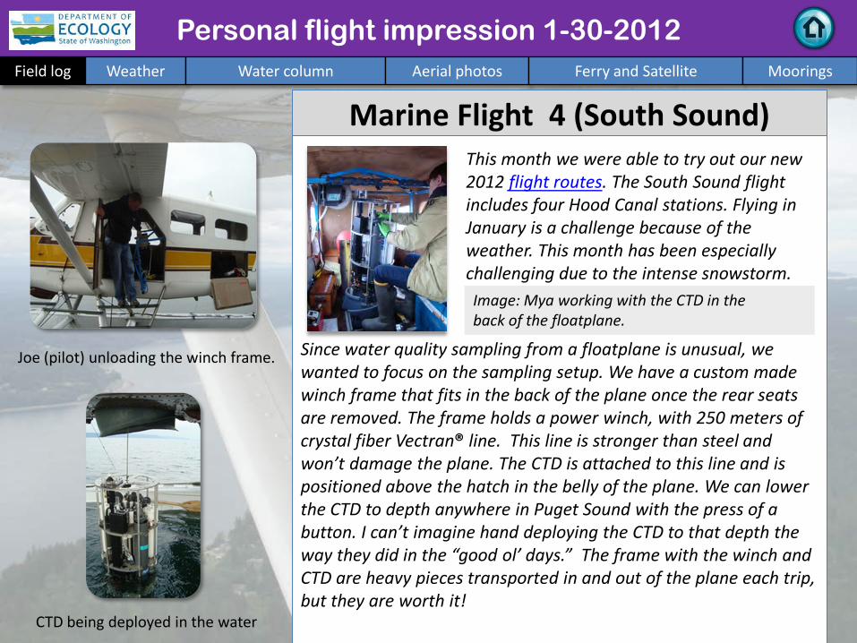
Personal flight impression 1-30-2012 Field log Weather Water column Aerial photos Ferry and Satellite Moorings
Marine Flight 4 (South Sound) Since water quality sampling from a floatplane is unusual, we wanted to focus on the sampling setup. We have a custom made winch frame that fits in the back of the plane once the rear seats are removed. The frame holds a power winch, with 250 meters of crystal fiber Vectran® line. This line is stronger than steel and won’t damage the plane. The CTD is attached to this line and is positioned above the hatch in the belly of the plane. We can lower the CTD to depth anywhere in Puget Sound with the press of a button. I can’t imagine hand deploying the CTD to that depth the way they did in the “good ol’ days.” The frame with the winch and CTD are heavy pieces transported in and out of the plane each trip, but they are worth it! CTD being deployed in the water
This month we were able to try out our new 2012 flight routes. The South Sound flight includes four Hood Canal stations. Flying in January is a challenge because of the weather. This month has been especially challenging due to the intense snowstorm.
Joe (pilot) unloading the winch frame.
Image: Mya working with the CTD in the back of the floatplane.

Seattle Aquarium and Skyline
Patches of sun in Commencement Bay
Personal flight impression 1-30-2012 Field log Weather Water column Aerial photos Ferry and Satellite Moorings
NEW Flight and Station Maps For 2012 we have shifted emphasis of our rotational monitoring effort to stations of the Kitsap Peninsula and Bainbridge Island. We will be visiting these stations:
• Port Gamble (PGA001) • Port Madison (PMA001) • Eagle Harbor (EAG001)
The data will allow us to determine if significant long-term trends in marine water quality occurred in this focus region.
Each of 4 regional flight routes are shown on the map, and will be conducted monthly.
Click here for more Info and station maps
Julia Bos
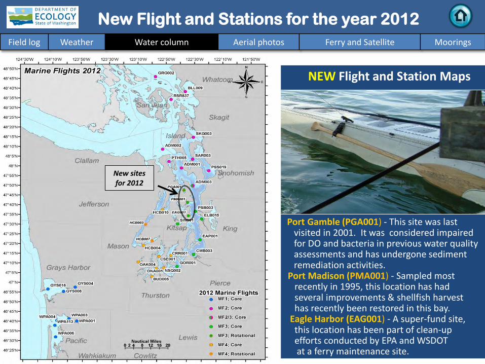
New sites for 2012
Port Gamble (PGA001) - This site was last visited in 2001. It was considered impaired for DO and bacteria in previous water quality assessments and has undergone sediment remediation activities.
Port Madison (PMA001) - Sampled most recently in 1995, this location has had several improvements & shellfish harvest has recently been restored in this bay. Eagle Harbor (EAG001) - A super-fund site, this location has been part of clean-up efforts conducted by EPA and WSDOT at a ferry maintenance site.
NEW Flight and Station Maps
New Flight and Stations for the year 2012 Field log Weather Water column Aerial photos Ferry and Satellite Moorings
Field log Weather Water column Aerial photos Ferry and Satellite Moorings
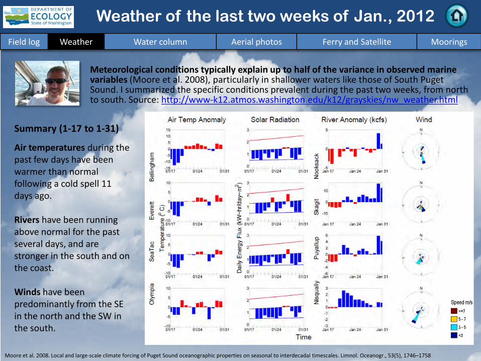
Meteorological conditions typically explain up to half of the variance in observed marine variables (Moore et al. 2008), particularly in shallower waters like those of South Puget Sound. I summarized the specific conditions prevalent during the past two weeks, from north to south. Source: http://www-k12.atmos.washington.edu/k12/grayskies/nw_weather.html
Moore et al. 2008. Local and large-scale climate forcing of Puget Sound oceanographic properties on seasonal to interdecadal timescales. Limnol. Oceanogr., 53(5), 1746–1758
Summary (1-17 to 1-31) Air temperatures during the past few days have been warmer than normal following a cold spell 11 days ago. Rivers have been running above normal for the past several days, and are stronger in the south and on the coast. Winds have been predominantly from the SE in the north and the SW in the south.
Weather of the last two weeks of Jan., 2012
Summary: Aerial Photography 1-30-2012
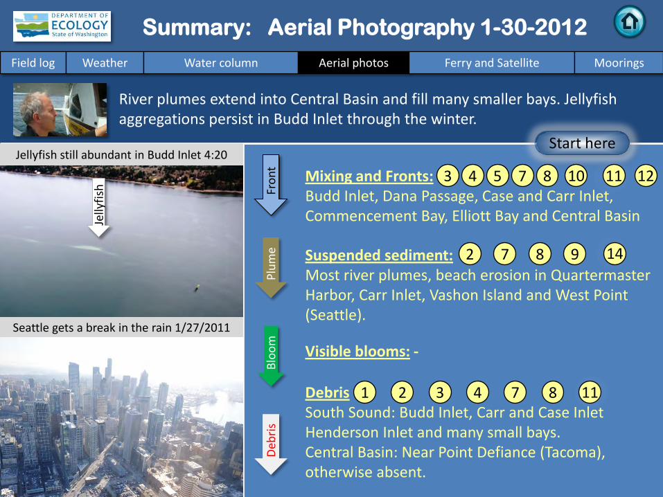
Mixing and Fronts: Budd Inlet, Dana Passage, Case and Carr Inlet, Commencement Bay, Elliott Bay and Central Basin
Debris South Sound: Budd Inlet, Carr and Case Inlet Henderson Inlet and many small bays. Central Basin: Near Point Defiance (Tacoma), otherwise absent.
Visible blooms: -
Suspended sediment: Most river plumes, beach erosion in Quartermaster Harbor, Carr Inlet, Vashon Island and West Point (Seattle).
River plumes extend into Central Basin and fill many smaller bays. Jellyfish aggregations persist in Budd Inlet through the winter.
Bloo
m
Deb
ris
Fron
t Pl
ume
Field log Weather Water column Aerial photos Ferry and Satellite Moorings
Start here
7 11
2
4
Seattle gets a break in the rain 1/27/2011
Jellyfish still abundant in Budd Inlet 4:20 PM 5
9
12
14
1
10
Jelly
fish
8 3
7 8
7 2 4 8 3 11
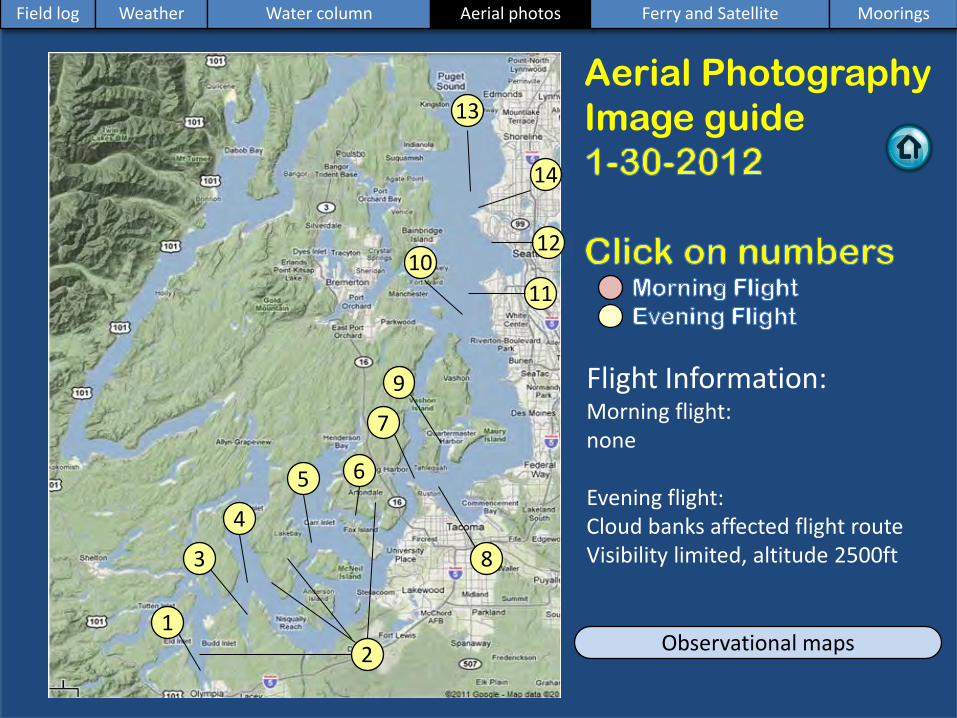
Aerial Photography Image guide
Observational maps 1
2
3
4
5 6
7
8
9
11
12 10
14
Flight Information: Morning flight: none Evening flight: Cloud banks affected flight route Visibility limited, altitude 2500ft
Field log Weather Water column Aerial photos Ferry and Satellite Moorings
13

Surface slick and foam lines. Location: Southern Budd Inlet, Gull Harbor 4:21 PM
1 Aerial photography Navigate
Field log Weather Water column Aerial photos Ferry and Satellite Moorings
Deb
ris
Deb
ris

A
C D
B 4:28 PM
4:25 PM 4:26 PM
4:23 PM
River plumes and sediment. Location: A-Gig Harbor, B-Gull Harbor, C-Taylor Bay, D-Filucy Bay
2 Navigate
Field log Weather Water column Aerial photos Ferry and Satellite Moorings
Aerial photography
Plum
e
Plum
e
Plum
e
Plum
e
Deb
ris
Deb
ris

Debris and front along shore. Location: Henderson Inlet, 4:23 PM
3 Navigate
Field log Weather Water column Aerial photos Ferry and Satellite Moorings
Aerial photography
jelly
fish
Fron
t
Deb
ris

Debris line. Location: Dana Passage connecting with Case Inlet, 4:25 PM
4 Navigate
Field log Weather Water column Aerial photos Ferry and Satellite Moorings
Aerial photography
Deb
ris
Deb
ris
Fron
t

Front over shallow water? Location: Carr Inlet near McNeil Island (South Sound), 4:27 PM
5 Navigate
Field log Weather Water column Aerial photos Ferry and Satellite Moorings
Aerial photography
Front
Deb
ris

Oil sheen. Location: Fox Island (South Sound), 4:28 PM
6 Navigate
Field log Weather Water column Aerial photos Ferry and Satellite Moorings
Aerial photography
Sheen

Plume, front and debris line. Location: Point Defiance (Central Sound), 4:30 PM
7 Navigate
Field log Weather Water column Aerial photos Ferry and Satellite Moorings
Aerial photography
Deb
ris

Plume, front and debris line. Location: Commencement Bay (Central Sound), 4:31 PM
8 Navigate
Field log Weather Water column Aerial photos Ferry and Satellite Moorings
Aerial photography
Fron
t Front
Plum
e
Debris

Beach erosion or river? Location: Quartermaster Harbor (Central Sound), 4:32 PM
9 Navigate
Field log Weather Water column Aerial photos Ferry and Satellite Moorings
Aerial photography
Sediment
Sediment
Sediment
Sediment

Front and breaking waves, Location: West Seattle in background (Central Sound), 4:40 PM
Aerial photography 10 Navigate
Field log Weather Water column Aerial photos Ferry and Satellite Moorings

Front. Location: Alki Point in background (Central Sound), 4:40 PM
11 Navigate
Field log Weather Water column Aerial photos Ferry and Satellite Moorings
Aerial photography
Fron
t
Deb
ris

River plume/debris lines and container ships. Location: Elliott Bay (Central Sound), 4:41 PM
12 Navigate
Field log Weather Water column Aerial photos Ferry and Satellite Moorings
Aerial photography
Front
Front
Plum
e
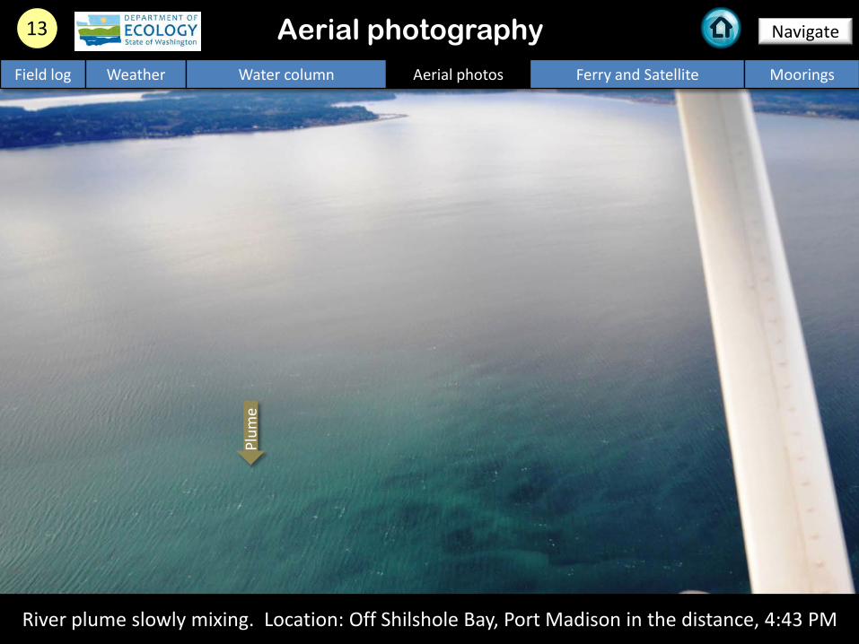
River plume slowly mixing. Location: Off Shilshole Bay, Port Madison in the distance, 4:43 PM
13 Navigate
Field log Weather Water column Aerial photos Ferry and Satellite Moorings
Aerial photography
Plum
e
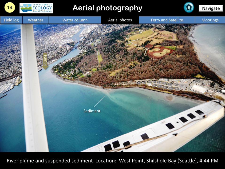
River plume and suspended sediment Location: West Point, Shilshole Bay (Seattle), 4:44 PM
14 Navigate
Field log Weather Water column Aerial photos Ferry and Satellite Moorings
Aerial photography
Plum
e
Sediment

Aerial photography observations in Central Sound
Numbers on map refer to picture numbers for spatial reference
Navigate
Field log Weather Water column Aerial photos Ferry and Satellite Moorings
7
8
9
11
12
10
14
13
1 2
3
4 5 6
For January 30, 2012 only the afternoon aerial flight was conducted.

Legend to map annotations
Comments: Maps are produced by observers during and after flights. They are intended to give an approximate reconstruction of the surface conditions on scales that connect to and overlap with satellite images in the section that follows.
Navigate
Field log Weather Water column Aerial photos Ferry and Satellite Moorings

MERIS True Color image used for spatial context (19 February 2011). Image is not coincident with ferry data shown on right
Contact: [email protected]
Daily ferry and satellite observations in Central Sound, 1-30-2012
Field log Weather Water column Aerial photos Ferry and Satellite Moorings
Current Conditions: Low fluorescence throughout Puget Sound; surface temperatures are 8-9 °C in Central Sound and <8 °C in the Strait of Juan de Fuca.
--- Daily ‘Quick-Look’ Products Available ---
(http://www.ecy.wa.gov/programs/eap/mar_wat/eops/clipper.html)
30 Jan 30 Jan

CDOM fluorescence as an indicator of
freshwater influence in Central Sound
A primary source of Colored
Dissolved Organic Matter (CDOM) to Puget Sound is
from rivers.
We expect to see highly colored water making its way
into Puget Sound later this week, associated with the
recent rainfall and high river flows in Whidbey Basin.
Field log Weather Water column Aerial photos Ferry and Satellite Moorings

We apologize, the mooring report is currently not available due to pressing technical maintenance work at one of our stations.
1. Mukilteo, Whidbey Basin near Everett: Not available due to maintenance work
2. Manchester, Central Sound: Not available due to maintenance work
3. Squaxin Passage (South Sound) near Olympia: Not available due to maintenance work
Mooring observation and trends
Go to our mooring site at: http://www.ecy.wa.gov/programs/eap/mar_wat/moorings.html
Field log Weather Water column Aerial photos Ferry and Satellite Moorings
Real-time data online (click)
Summary: Not available due to maintenance work

Access mooring data:
http://www.ecy.wa.gov/programs/eap/mar_wat/mo
orings.html
Ferry and satellite : [email protected]
a.gov
Get your data from Ecology’s Environmental Assessment Program
Long – Term Monitoring Network
Real – Time Sensor Network
Access core monitoring data: http://www.ecy.wa.gov/apps/eap/marinewq/mwda
taset.asp
Aerial survey: ftp://www.ecy.wa.gov/eap
/Flight_Blog/
Ecology’s long-term marine monitoring stations
Ferry track Morning flight Evening flight
Freshwater Report: ftp://ecy.wa.gov/eap/FreshwaterReport/Ambient_Monitoring-Monthly_Summary.html
Field log Weather Water column Aerial photos Ferry and Satellite Moorings

You may subscribe or unsubscribe to the Eyes Over Puget Sound email listserv by going to:
http://listserv.wa.gov/cgi-bin/wa?A0=ECOLOGY-EYES-OVER-PUGET-SOUND
Many thanks to our business partners: Clipper Navigation, Swantown Marina and Kenmore Air.
We are looking for feedback to improve our products.
Dr. Christopher Krembs [email protected]
Marine Monitoring Unit
Environmental Assessment Program WA Department of Ecology
Field log Weather Water column Aerial photos Ferry and Satellite Moorings