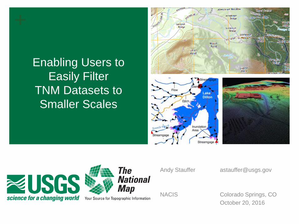
Enabling Users to Easily Filter TNM Datasets to Smaller Scales
16
+ Enabling Users to Easily Filter TNM Datasets to Smaller Scales Andy Stauffer [email protected] NACIS Colorado Springs, CO October 20, 2016
-
Upload
nacisslides -
Category
Design
-
view
36 -
download
0
Transcript of Enabling Users to Easily Filter TNM Datasets to Smaller Scales
+
Enabling Users to Easily Filter
TNM Datasets to Smaller Scales
Andy Stauffer [email protected] NACIS Colorado Springs, CO October 20, 2016
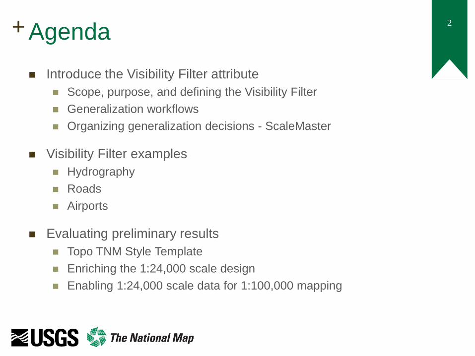
2 + Agenda Introduce the Visibility Filter attribute
Scope, purpose, and defining the Visibility Filter Generalization workflows Organizing generalization decisions - ScaleMaster
Visibility Filter examples Hydrography Roads Airports
Evaluating preliminary results Topo TNM Style Template Enriching the 1:24,000 scale design Enabling 1:24,000 scale data for 1:100,000 mapping

3 + What is the VisibilityFilter Attribute?
Database enrichment that represents results of a generalization process Intend to implement with 9 benchmark scales; focus on 1:100K and 1:250K
Defines the smallest applicable scale of use for a feature within TNM datasetes ‘Level of Content’ vs. ‘Level of Detail’
Draft Model Definition: The VisibilityFilter attribute represents appropriate use of individual features through scale. The attribute does not reflect capture conditions. Data are captured per respective scale-specific specifications. The VisibilityFilter attribute is intended only to direct appropriate end use of the data. A given VisibilityFilter coded-value indicates that the object is appropriate for use at approximately the defined scale and all larger scales [i.e., an object with a given VisibilityFilter is not appropriate for use at scales smaller than the defined approximate scale]
Presenter
Presentation Notes
We are intending to implement the Visibility Attribute with 9 benchmark scales 1:24,000, 1:50,000, 1:100,000, 1:150,000, 1:250,000, �1:500,000, 1:1,000,000, 1:2,000,000, 1:5,000,000 Geometric generalization is not considered or applied here. The goal of this is to ‘standardize’ scale-appropriate content. Geometric generalization is often driven by application purpose and is frequently much more variable. The derived Level-of-Content provides a useful springboard for users to quickly filter the data prior to applying further generalization processes.

4 + Defining the VisibilityFilter
SELECT * FROM [dataset] WHERE VisibilityFilter >= [scale denominator]
Presenter
Presentation Notes
The Visibility Filter is gradually built as data is generalized. First, data is first tagged with its source scale. In this case, the entire database is populated with 1:24,000. The first intermediate LOD is generated. The “surviving” content is linked back to the source dataset and the visibility filter value updated for the successfully linked features. This process continues and the attribute is overwritten until all benchmark scales are processed.

5 + Formalizing generalization decisions: Developing a ScaleMaster
ScaleMaster developed by NGTOC employees Brittany Roche and Seth Webinger, FY2016
Presenter
Presentation Notes
A ScaleMaster chart and description has been generated for the entire TNM data model, consisting of over 200 feature types. For the first prototype, collection criteria was extracted from historical mapping documents and instructions. These help to define the filtering methodologies and parameters to depict data at a given benchmark scale (either 100K or 250K in the prototype). In the future, the descriptions of this chart will be used to help automate the generalization process. A modular generalization process is tagged to each feature type at each benchmark scale. In addition, the processing parameters are also stored in the ScaleMaster. This allows easy manipulation of the generalization process through alteration of this diagram. We will continue to refine and expand this process in the future.
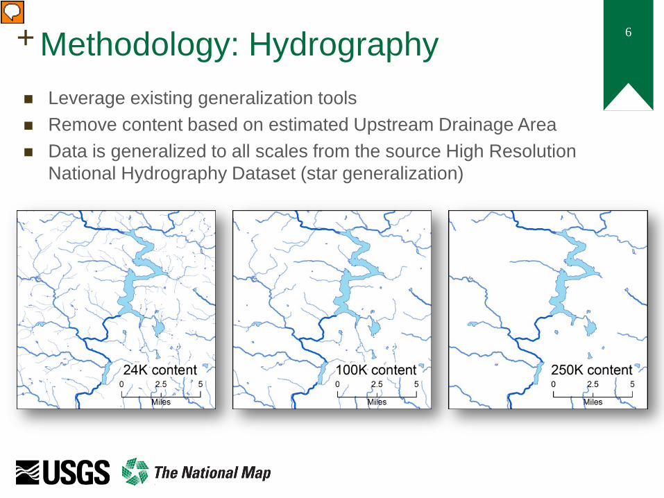
6 + Methodology: Hydrography Leverage existing generalization tools Remove content based on estimated Upstream Drainage Area Data is generalized to all scales from the source High Resolution
National Hydrography Dataset (star generalization)
Presenter
Presentation Notes
By using modeled feature densities of the as guidelines, the National Hydrographic Dataset is gradually reduced until the feature density matches the estimates provided by the radical law. Cumulative upstream drainage area is calculated for each NHD feature which assigns a relative hierarchy within the network. Hydrographic features are slowly removed until the network density matches the modeled target densities. To maintain network integrity, the NHD is generalized from the source 1:24,000 scale to each smaller target scale. This avoids creating gaps and breaks within the network as segments are pruned instead of entire confluence-to-confluence features. Once all the generalization has occurred, the Level-of-detail datasets are recombined to complete the VisibilityFilter enrichment.
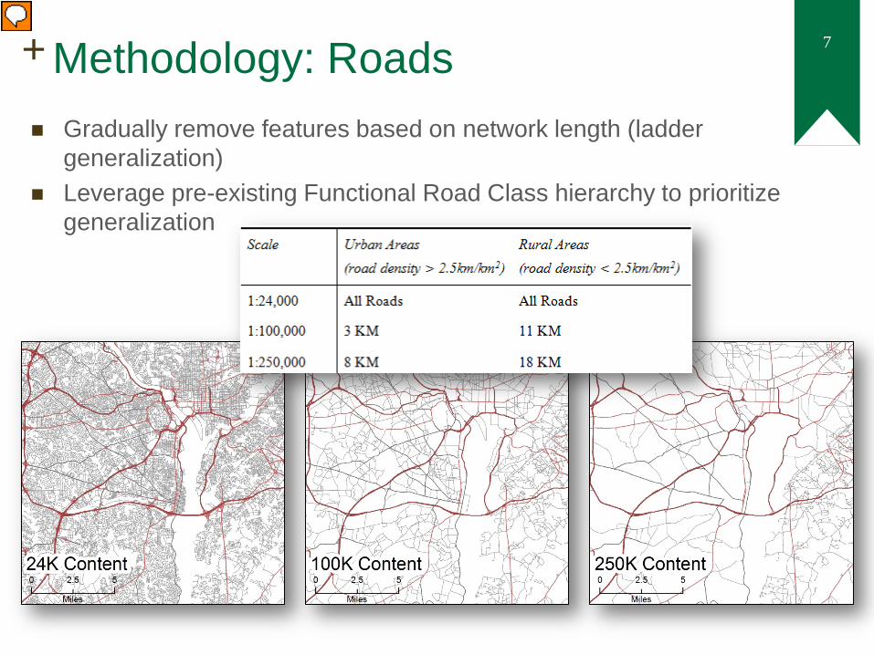
7 + Methodology: Roads
; from Brewer et al. 2013
Gradually remove features based on network length (ladder generalization)
Leverage pre-existing Functional Road Class hierarchy to prioritize generalization
Presenter
Presentation Notes
Roads are processed in a similar manner to hydrography. The processing happens differently based on the context of the data. In rurally defined areas (or areas that are less dense in content), the generalization is much more lenient and more content is retained. In urban or feature-dense areas, generalization is much more aggressive. In addition, roads use a pre-existing feature hierarchy perform the generalization differently to each feature type. This often reduces the clutter of minor features at smaller scales while still retaining as much of the underlying data structure as possible.

8 + Methodology: Airports
SELECT * FROM AirportPoint WHERE AirportPoint.VisibilityFilter >= [scale denominator] AND AirportRunway.VisibilityFilter < [scale denominator] INNER JOIN AirportPoint ON AirportRunway.FAA = AirportPoint.FAA
Measure and group length of features (apply minimum and maximum length restrictions)
Mimic feature collapses and dimensionality changes through table joins
Presenter
Presentation Notes
One of the recurring selection criteria in the historical documents was to filter content by a minimum length in either the smallest or largest dimension. In this example, Airports are examined based on a minimum runway length. The largest dimension length is extracted for each of the features and grouped based on a shared attribute. Some feature types within the TNM model are duplicative. Airports and Cemeteries are an example. In each of these cases, both polygonal and point data exists. By joining the geometries together with a like-attribute, a geometric collapse can be achieved.
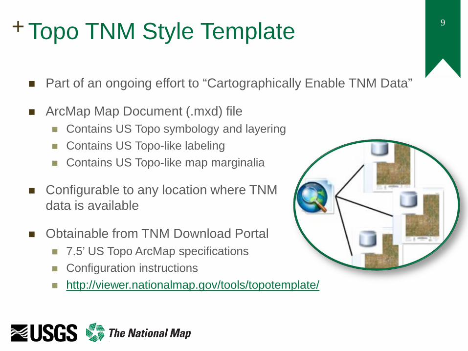
9 + Topo TNM Style Template
Part of an ongoing effort to “Cartographically Enable TNM Data”
ArcMap Map Document (.mxd) file Contains US Topo symbology and layering Contains US Topo-like labeling Contains US Topo-like map marginalia
Configurable to any location where TNM data is available
Obtainable from TNM Download Portal 7.5’ US Topo ArcMap specifications Configuration instructions http://viewer.nationalmap.gov/tools/topotemplate/

10 + Topo TNM Style Template: Use at 1:24,000 scale The Topo TNM Style
Template is set up to mimic the design of the US Topo product
The 1:24,000 scale content is shown at its native scale
The content is clearly displayed and only minor symbology / labeling problems exist in a fully automated fashion
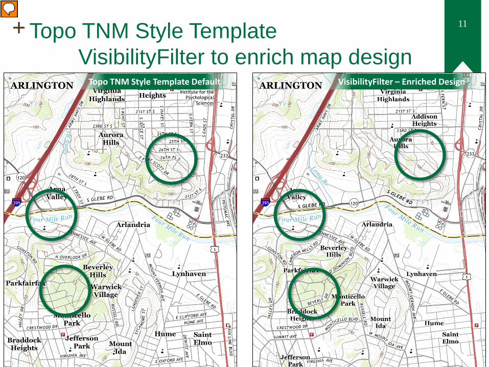
11 + Topo TNM Style Template VisibilityFilter to enrich map design
Topo TNM Style Template Default VisibilityFilter – Enriched Design
Presenter
Presentation Notes
The Visibility Filter can help in supplementing the existing design. The focus here is on Roads and Hydrography. The data enrichment enables the creation of a hierarchy within a single feature type. The symbol width of the Local Roads can be exaggerated to coerce new ‘local connector’ information into the road network. Road label clutter can be reduced while ensuring major roads and thoroughfares are retained. Similarly, a hierarchy can be established within the stream network based on estimated catchment area. This helps to define and represent the potential growth of a river through a map.

12 + Topo TNM Style Template Scale reduction to 1:100,000
Zooming out in the Topo TNM Style template mimics a photoreduction of the map
The data and labels are linked to the source, 1:24,000, scale.
All 1:24,000 scale content is visible but illegible

13 + Topo TNM Style Template: Rendering map at 1:100,000
By changing the display scale to 1:100,000, the content becomes overwhelming
All 1:24,000 content is still visible, but too dense to generate a clear map

14 + Topo TNM Style Template: VisibilityFilter to reduce scale
Presenter
Presentation Notes
The Visibility Filter attribution can enable data to be used at smaller scales. Primarily, the attribute achieves this through content reduction using the hierarchies incorporated into the data. As ‘minor’ features are removed, the structure of the data is maintained as seen in the downtown road network. Removing content also helps to reduce label complexity and conflicts while retaining locally significant features through scale as the map design can support. While displayed at a smaller scale, the Visibility Filter attribute maintains the same look and feel as depicted on the 1:24,000 scale US Topo product.

15 + Accomplishments and Future Work
Accomplishments VisibilityFilter attribute
prototyped in many TNM feature types
Generalization framework for implementing VisibilityFilter attribute has been mocked up for two benchmark scales
Cartographic use of TNM data can be used fairly easily at smaller scales in Topo TNM Style Template
Future Work Continue to evaluate use of
VisibilityFilter in other feature types, especially boundaries
Evaluate how to extrapolate results to an additional seven benchmark scales (1:50K to 1:5M)
Document ‘best practices’ for cartographic use of TNM data at smaller scales, perhaps with simplification information
+ Enabling Users to
Easily Filter TNM Datasets to Smaller Scales
QUESTIONS
Andy Stauffer [email protected] NACIS 2016 Colorado Springs, CO October 20, 2016