Xu ZHOU Liaison Representative from PCGIAP to ISO/TC 211 National Geomatics Center of China

ELF and the use of standards
ISO/TC 211 and OGC standards
Olaf Magnus Østensen Chair of ISO/TC 211
Co-ordinator ELF-project
International Organization for Standardization
TC 211

Two ISO/OGC/IHO initiatives: Collaboration of SDOs and Study Group on SDG
• UN-GGIM session 5, August 2015 in New York, from the Report (5/108):
….
(e) Noted the need for the further development of harmonized and interoperable
standards between the statistical and geospatial communities, expressed its
appreciation to the standards organizations for their increased efforts in this area, and
encouraged Member States to contribute to these efforts, in particular through
collaboration with the Expert Group on the Integration of Statistical and Geospatial
Information;
(f) Urged Member States to participate in the proposed joint study group and in the
international geospatial standards development processes of the Open Geospatial
Consortium, the Technical Committee 211 of the International Organization for
Standardization and the International Hydrographic Organization and other relevant
standards bodies, in order to ensure that the geospatial standards required to monitor
and measure the sustainable development goals are relevant and available.
….

Content
• Status of initiatives • Collaboration on standards • Study of SDGs and targets
• Overview of ELF • ELF concept • Data content • Services • Licensing
• Integrating statistics • Table Joining Service • CASPeR client
• Future of ELF • Organizational setup

Relevant standards bodies
• ISO/TC 69 Applications of statistical methods • Sampling, testing, accuracy – 102 standards
• ISO/TC 154 Processes, data elements and documents in commerce, industry and administration • ISO 17369:2013 Statistical data and metadata exchange
(SDMX) (also ) • else, standards for commerce, EDIFACT, ebXML, …
• in geospatial, ISO/TC 211, OGC, IHO
• in IT, W3C, OASIS, IETF, …
• …

The existing core standards extract …
• SDMX
• ISO 19103, 19109, 19115, …
• O&M (ISO 19156), ISO 19112
• GML (ISO 19136)
• WMS (ISO 19128)
• WFS (ISO 19142)
• WCS
• TJS
• ISO 19152 LADM
• ISO 19160 series on addressing
• ….

Metadata
• INSPIRE metadata – datasets and services
• ISO 19115-1:2014 – Geographic information – Metadata – Part 1: Fundamentals
• ISO 19115-2:2008 – Geographic information – Metadata – Part 2: Extensions for imagery and gridded data (under revision)
• ISO 19115-3 – Geographic information - Metadata - Part 3: XML schema implementation of metadata fundamentals
• DCAT AP - for describing public sector datasets in Europe
• DCAT - interoperability between data catalogs

Draft JSG report - ISO/OGC

Not more than a template yet …

Main title
Content
The European Location Framework is a
technical infrastructure which delivers
authoritative, interoperable, cross-border
geospatial reference data for analysing and
understanding information connected to
places and features
What is ELF? … in short:

A single access point to pan-European services
ELF cloud platform ELF platform

It is all about the Content!
Malta
Project partner countries 20)
Data provider outside project (4)
Contributors to ELF Global/Regional through EuroGeographics products ERM,EGM,EBM
Data content providers in 2016/17

ELF data content and specifications
Supported versions
• INSPIRE v3
• ELF v1/INSPIRE v4

Details on versions
• INSPIRE version 3
• ELF version 1.0 • Based upon INSPIRE version 4 (where version 4 exists)
• Extensions for the following themes • AU – Administrative units
• TN – Transport networks (common elements, air, railway, road, water)
• GN - Geographical names
• HY – Hydrography (network, physical waters)
• mostly caused by legacy requirements, e.g. EuroGeographics products EBM, ERM, and additional requirements, e.g. from Eurostat

State-of-the-art modelling using International Standards and ELF modelling guidelines
Precise data specifications – a necessity for evidence-based decisions
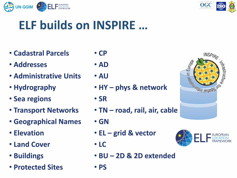
• Cadastral Parcels
• Addresses
• Administrative Units
• Hydrography
• Sea regions
• Transport Networks
• Geographical Names
• Elevation
• Land Cover
• Buildings
• Protected Sites
• CP
• AD
• AU
• HY – phys & network
• SR
• TN – road, rail, air, cable
• GN
• EL – grid & vector
• LC
• BU – 2D & 2D extended
• PS
ELF builds on INSPIRE …
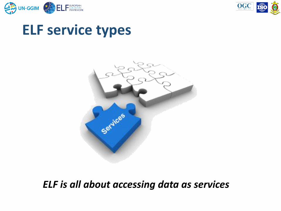
ELF service types
ELF is all about accessing data as services

ELF highlights
• The ELF basemap – administrative and topographic
• The cadastral index map – including parcels, addresses and buildings
• The ELF download services
• The cascaded download services
• The Geolocator
• The Geo Product Finder
• The geotools

Download services – the key ELF service type
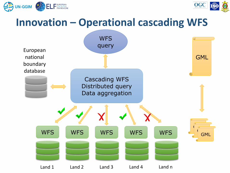
Innovation – Operational cascading WFS
Cascading WFS Distributed query Data aggregation
European national
boundary database
WFS WFS WFS WFS WFS
WFS query
Land 1 Land 2 Land 3 Land 4 Land n
GML GML
GML
GML

Some other key ELF Products
• ELF Topographic Basemap • WMTS
• ELF Administrative Basemap • WMS using EuroBoundaryMap
• ELF Cadastral Index Map • Cascading WMS using CP, BU,
AD and AU
• ELF Geo Locator • Geo-referencing API using GN,
AD and AU

Implementation plan -> October 2016
Country BE NL GB IE FR ES PT NO FI SE DK IS LT LV DE PL CZ SI RS HU
ELF Basemap
Cadastral Index Map
Download services
Download AU
Download GN
Download_HY-PW
Download_HY-NW
Download_LC
Download_TN-Air
Download_TN-Road
Download_TN-Rail
Download_TN-Cable
Download_TN-Water
Download_EL
Download_EL Grid
Download_BU_2D
Download_BU_Ex
Download_AD
Download_CP
Download_PS
Download_SR
Download_SU

ELF Geotools
Transformation
Data Quality Validation
Generalisation
Edge Matching
Visualisation
Change Detection
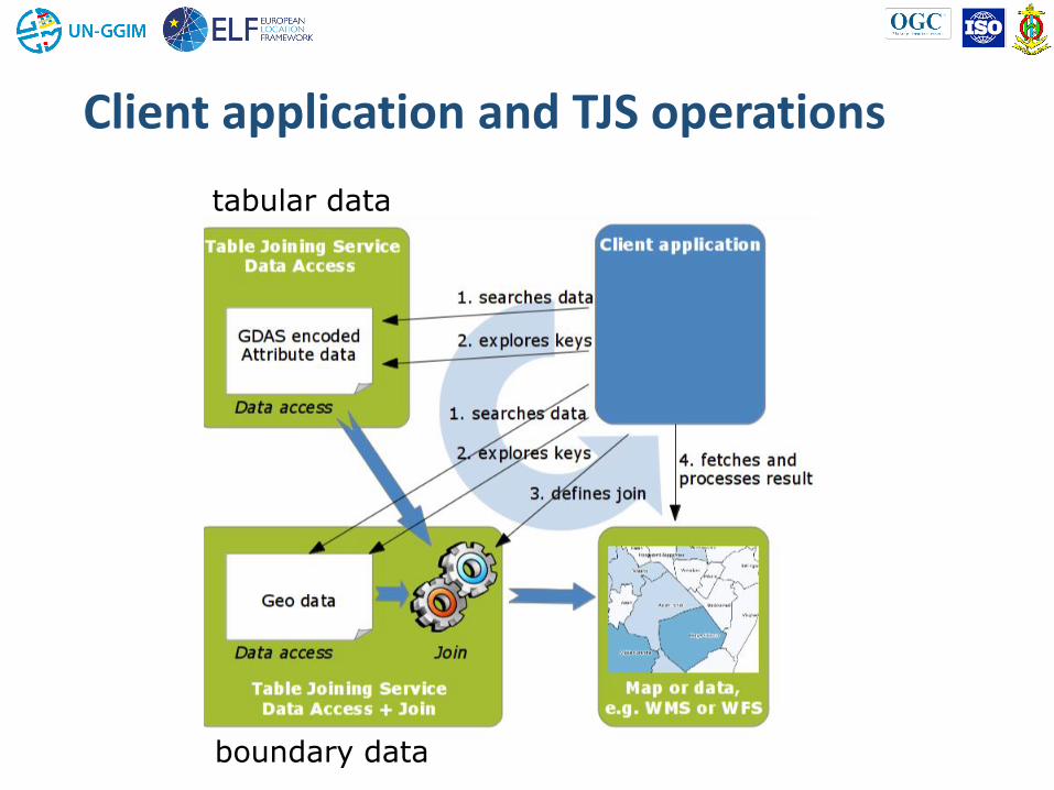
Table Joining Service
Security Manager

tabular data
boundary data
OGC TJS
Unique id’s
(keys)
Table joining (service) and unique id’s (keys)
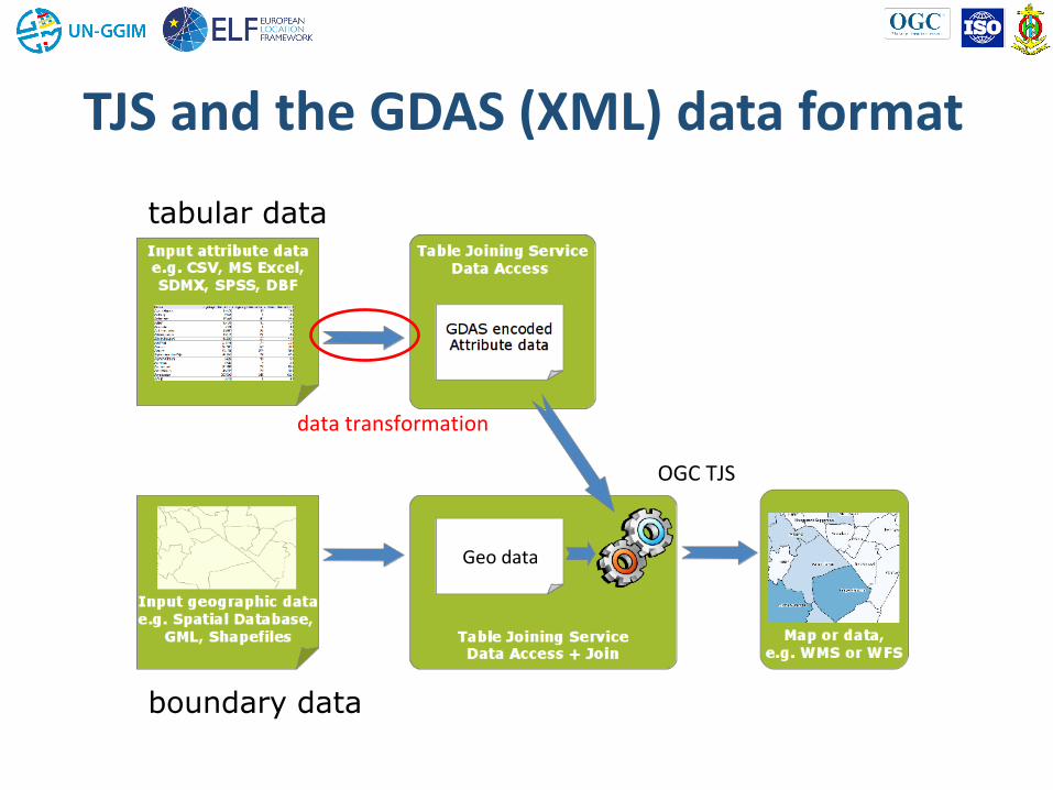
tabular data
boundary data
data transformation
Geo data
OGC TJS
TJS and the GDAS (XML) data format
tabular data
boundary data
Client application and TJS operations

OGC TJS operations


data tables
(SDMX)
Download
Service
SDMX
to
GDASEuroSTAT
E.L.F. - Oskari PlatformEuroboundarymap
Health statistics
Cached
data
Casper
(GINST)
Geographic
data
Download
Service
WFS
TJS test
demonstrator
(Kadaster)
TJS join
Download
Service
Download
Service
WFSWMS
Join
Service
TJS
Other
clients
Transformation
Service
SDMX
REST
Architecture deployment E.L.F. health statistics application

Mapping European health statistics
Eurostat’s health statistics
(>300 tables)
TJS
ELF platform
Administrative Units
4. Intro gezondheidsstatistieken app
(E.L.F.)
CASPeR
application

Eurostat’s health statistics (>300 tables)

GDAS Transformation tool
Input standards:
SDMX
Odata - Open Data Protocol
CSV
TJS tabular data transformation tool

7. TJS software (Geoserver) repository
TJS as a GEOSERVER community plugin
Open source project
Code public available on GitHub:
https://github.com/thijsbrentjens/geoserver/tree/tjs_2.2.x/
TJS implementation

The Future of ELF
Design
Development
Test Services
Market
The ELF-project 2013-2016
EuroGeographics and partners
Research ESDIN 2008-2011
… from ELF project the European Location Services – ELS …

Timescales
European Location Services
2018
2013 Project start
May 2016 • Testing
2016
Oct 2016 • Project end
• Transition phase
begins
2016 – 2018 • Development of an
Operational service
2013 2015
ELF Project Consortium EuroGeographics

Activity Components
Governance
Support processes
Data
providers
Supplier
relations
Product Management
Infrastructure management
Software
management ELF
users
User support
Marketing
Account mgt/
Sales Data and
Quality
management
Services
management

Governance Structure
10 May, 2016
ELS management board
Chair: Eurogeographics
ELS Product
marketing and
supply group
Chair:
ELS Technical
systems group
Chair:
ELS Data and
service supply
group
Chair:
Partnership
Forum User Group
Note: the Governance structure serves to advise Eurogeographics on the
strategic aspects of ELF, involving the relevant partners. This is NOT and
Operational management structure. Development projects are not in the
operational structure but are managed from the management board.
Development
projects
EG
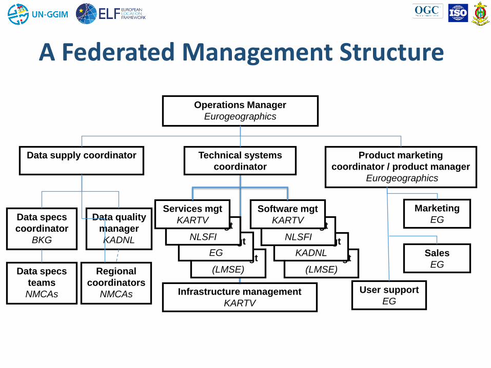
A Federated Management Structure
10 May, 2016
Services mgt
(LMSE)
Operations Manager
Eurogeographics
Product marketing
coordinator / product manager
Eurogeographics
Technical systems
coordinator
Data supply coordinator
Data specs
coordinator
BKG
Data quality
manager
KADNL
Regional
coordinators
NMCAs Infrastructure management
KARTV
Data specs
teams
NMCAs
Marketing
EG
Sales
EG
User support
EG
Services mgt
EG
Services mgt
NLSFI
Services mgt
KARTV
Services mgt
(LMSE)
Services mgt
KADNL
Services mgt
NLSFI
Software mgt
KARTV

Thenk you for your attention!